DIGITAL DATABASE AND VISUALISATION OF TOURIST VALUES …
7
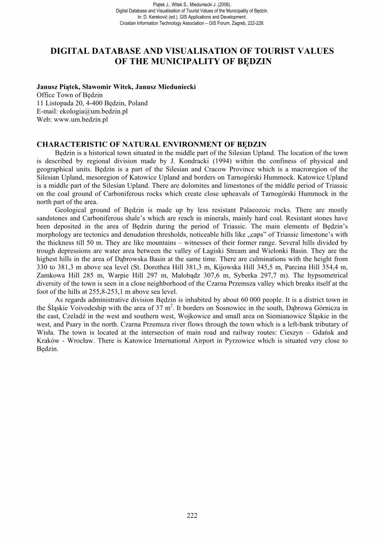
222 DIGITAL DATABASE AND VISUALISATION OF TOURIST VALUES OF THE MUNICIPALITY OF BĘDZIN Janusz Piątek, Sławomir Witek, Janusz Mieduniecki Office Town of Będzin 11 Listopada 20, 4-400 Będzin, Poland E-mail: [email protected] Web: www.um.bedzin.pl CHARACTERISTIC OF NATURAL ENVIRONMENT OF BĘDZIN Będzin is a historical town situated in the middle part of the Silesian Upland. The location of the town is described by regional division made by J. Kondracki (1994) within the confiness of physical and geographical units. Będzin is a part of the Silesian and Cracow Province which is a macroregion of the Silesian Upland, mesoregion of Katowice Upland and borders on Tarnogórski Hummock. Katowice Upland is a middle part of the Silesian Upland. There are dolomites and limestones of the middle period of Triassic on the coal ground of Carboniferous rocks which create close upheavals of Tarnogórski Hummock in the north part of the area. Geological ground of Będzin is made up by less resistant Palaeozoic rocks. There are mostly sandstones and Carboniferous shale’s which are reach in minerals, mainly hard coal. Resistant stones have been deposited in the area of Będzin during the period of Triassic. The main elements of Będzin’s morphology are tectonics and denudation thresholds, noticeable hills like „caps” of Triassic limestone’s with the thickness till 50 m. They are like mountains – witnesses of their former range. Several hills divided by trough depressions are water area between the valley of Łagiski Stream and Wielonki Basin. They are the highest hills in the area of Dąbrowska Basin at the same time. There are culminations with the height from 330 to 381,3 m above sea level (St. Dorothea Hill 381,3 m, Kijowska Hill 345,5 m, Parcina Hill 354,4 m, Zamkowa Hill 285 m, Warpie Hill 297 m, Małobądz 307,6 m, Syberka 297,7 m). The hypsometrical diversity of the town is seen in a close neighborhood of the Czarna Przemsza valley which breaks itself at the foot of the hills at 255,8-253,1 m above sea level. As regards administrative division Będzin is inhabited by about 60 000 people. It is a district town in the Śląskie Voivodeship with the area of 37 m 2 . It borders on Sosnowiec in the south, Dąbrowa Górnicza in the east, Czeladź in the west and southern west, Wojkowice and small area on Siemianowice Śląskie in the west, and Psary in the north. Czarna Przemsza river flows through the town which is a left-bank tributary of Wisła. The town is located at the intersection of main road and railway routes: Cieszyn – Gdańsk and Kraków - Wrocław. There is Katowice International Airport in Pyrzowice which is situated very close to Będzin. Piątek J., Witek S., Mieduniecki J. (2006). Digital Database and Visualisation of Tourist Values of the Municipality of Będzin. In: D. Kereković (ed.). GIS Applications and Development. Croatian Information Technology Association – GIS Forum, Zagreb, 222-228.
Transcript of DIGITAL DATABASE AND VISUALISATION OF TOURIST VALUES …
222
DIGITAL DATABASE AND VISUALISATION OF TOURIST VALUES OF THE MUNICIPALITY OF BĘDZIN
Janusz Piątek, Sławomir Witek, Janusz Mieduniecki Office Town of Będzin 11 Listopada 20, 4-400 Będzin, Poland E-mail: [email protected] Web: www.um.bedzin.pl
CHARACTERISTIC OF NATURAL ENVIRONMENT OF BĘDZIN Będzin is a historical town situated in the middle part of the Silesian Upland. The location of the town
is described by regional division made by J. Kondracki (1994) within the confiness of physical and geographical units. Będzin is a part of the Silesian and Cracow Province which is a macroregion of the Silesian Upland, mesoregion of Katowice Upland and borders on Tarnogórski Hummock. Katowice Upland is a middle part of the Silesian Upland. There are dolomites and limestones of the middle period of Triassic on the coal ground of Carboniferous rocks which create close upheavals of Tarnogórski Hummock in the north part of the area.
Geological ground of Będzin is made up by less resistant Palaeozoic rocks. There are mostly sandstones and Carboniferous shale’s which are reach in minerals, mainly hard coal. Resistant stones have been deposited in the area of Będzin during the period of Triassic. The main elements of Będzin’s morphology are tectonics and denudation thresholds, noticeable hills like „caps” of Triassic limestone’s with the thickness till 50 m. They are like mountains – witnesses of their former range. Several hills divided by trough depressions are water area between the valley of Łagiski Stream and Wielonki Basin. They are the highest hills in the area of Dąbrowska Basin at the same time. There are culminations with the height from 330 to 381,3 m above sea level (St. Dorothea Hill 381,3 m, Kijowska Hill 345,5 m, Parcina Hill 354,4 m, Zamkowa Hill 285 m, Warpie Hill 297 m, Małobądz 307,6 m, Syberka 297,7 m). The hypsometrical diversity of the town is seen in a close neighborhood of the Czarna Przemsza valley which breaks itself at the foot of the hills at 255,8-253,1 m above sea level.
As regards administrative division Będzin is inhabited by about 60 000 people. It is a district town in the Śląskie Voivodeship with the area of 37 m2. It borders on Sosnowiec in the south, Dąbrowa Górnicza in the east, Czeladź in the west and southern west, Wojkowice and small area on Siemianowice Śląskie in the west, and Psary in the north. Czarna Przemsza river flows through the town which is a left-bank tributary of Wisła. The town is located at the intersection of main road and railway routes: Cieszyn – Gdańsk and Kraków - Wrocław. There is Katowice International Airport in Pyrzowice which is situated very close to Będzin.
Piątek J., Witek S., Mieduniecki J. (2006).Digital Database and Visualisation of Tourist Values of the Municipality of Będzin.
In: D. Kereković (ed.). GIS Applications and Development.Croatian Information Technology Association – GIS Forum, Zagreb, 222-228.
223
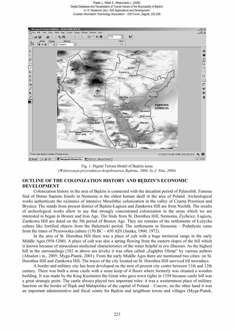
Fig. 1. Digital Terrain Model of Będzin areas
(Waloryzacja przyrodniczo-krajobrazowa Będzina, 2004, by J. Nita, 2004) OUTLINE OF THE COLONIZATION HISTORY AND BĘDZIN’S ECONOMIC DEVELOPMENT
Colonization history in the area of Będzin is connected with the decadent period of Palaeolith. Famous find of Homo Sapiens fossils in Siemonia is the oldest human skull in the area of Poland. Archeological works authenticate the existence of intensive Mesolithic colonization in the valley of Czarna Przemsza and Brynica. The stands from present district of Będzin-Łagisza and Zamkowa Hill are from Neolith. The results of archeological works allow to say that strongly concentrated colonization in the areas which we are interested in began in Bronze and Iron Age. The finds from St. Dorothea Hill, Siemonia, Żychcice, Łagisza, Zamkowa Hill are dated on the 5th period of Bronze Age. They are remains of the settlements of Łużycka culture like fortified objects from the Halsztacki period. The settlements in Siemonia – Podmłynie came from the times of Przeworska culture (150 BC – 450 AD) (Jamka, 1960; 1972).
In the area of St. Dorothea Hill there was a place of cult with a huge territorial range in the early Middle Ages (950-1200). A place of cult was also a spring flowing from the eastern slopes of the hill which is known because of miraculous medicinal characteristics of the water helpful in eye illnesses. As the highest hill in the surroundings (382 m above sea levels) it was often called „Zagłębie Olimp” by various authors (Absalon i in., 2005; Myga-Piatek, 2001). From the early Middle Ages there are mentioned two cities: on St. Dorothea Hill and Zamkowa Hill. The traces of the city located on St. Dorothea Hill survived till nowadays.
A border and military city has been developed on the area of present city centre between 11th and 12th century. There was built a stone castle with a stone keep of 4 floors where formerly was situated a wooden building. It was made by the King Kazimierz the Great who gave town rights in 1358 because castle hill was a great strategic point. The castle always played two important roles: it was a westernmost place of military function on the border of Śląsk and Małopolska of the capital of Poland – Cracow, on the other hand it was an important administrative and fiscal centre for Będzin and neighbour towns and villages (Myga-Piatek,
Piątek J., Witek S., Mieduniecki J. (2006). Digital Database and Visualisation of Tourist Values of the Municipality of Będzin.
In: D. Kereković (ed.). GIS Applications and Development. Croatian Information Technology Association – GIS Forum, Zagreb, 222-228.
224
2001). Since its beginning Będzin was a royal town what made easier to be well-developed in the social and economic field.
In 18th century there was a seat of well-known Polish magnate and noble houses which built palace and park complexes. In 18th and 19th century Będzin was changed into an important centre of mining industry. Formerly, it was important merchant and craft centre in the country. In 19th and 20th century hard coal was a decisive factor of the town development. Since 19th century there was an intensive exploitation of this raw material. In 1857 there was established a cement mill which was the first in Poland and the fifth in the world. There was a quarry on Warpie Hill which produced stone needed in strongly developing building industry. The process of industrialisation had an influence on building Warsaw and Vienna Railway. At the end of 19th century there was 11 coal mines, cement mill, steelworks and zinc steel mill in Będzin.
After the Second World War Będzin has been developing as a typical industrial town. There was seen a development of power industry, and in one of Będzin’s district – Łagisza – there was established a power station - one of the biggest in Poland. There were built many housing estates with big slabs for people who came here to work in mining, power and steel industry. There have been heightened unfavorable changes within the confines of spatial image of the town because there were seen very fast and spontaneous architectural changes in the suburbs and former suburban colonies.
Nowadays, there is being developed a new sphere of services together with general tendency of changes in the economic profile of Poland. The municipality is still a multiregional trade centre because of long trade tradition coming from royal privileges. Next important field in the future town image is a sphere of tourist services. A basis of this thesis are rich and various resources of natural and cultural heritage of the town. A ROLE OF TOURISM IN THE ECONOMIC ACTIVITY OF THE MUNICIPALITIES
Tourism is considered as a phenomenon of people’s spatial activities connected with temporary changes of place of living, environment and life rhythm.
Tourist activity can be divided into: purpose and motive of trip, time of stay, place of accommodation, character of stay, mean of transport, extent of tourists’ activities, way of tourist organization. Będzin is a place of great tourist attractiveness with a lot of resources and tourist values. Among the factors needed in tourist development there are: close neighborhood of big urban and industrial areas, permanent increase of transport access of this area, growing diversity of a tourist product with ability to fast reactions on the market needs, building up network of travel agencies, hotels, tourist buildings, even bigger ability to adapt European requirements and standards, increase of interest in specialized, alternative and ecological tourism. Fashion to active life style and educational and learning rest is conducive to a tourist function of the town. As an answer to these needs there is a systematically developing educational network – Centres of Ecological Education, teaching routes, tourist education of staff.
The results of development of the tourist functions can be seen in the following spheres: - spatial development sphere – (new model of spatial development, taking summer-resort plots,
new tourist buildings, means of transport into consideration, changes of the area usage); - in natural environment – (influence on all its components and physiognomy – landscape); - in economy – (making a new profile of small industry and craftsmanship, agricultural
specialization, specialized services); - in social and cultural sphere – (changes of professional structure of the inhabitants – a positive
influence on decrease of the unemployment rate, changes of owner-occupied conditions, making a new life style according to new cultural standards, risk of disappearance of autonomy and familiarity of the region, making a tourist “market”);
- in political and administrative institutions – (adjustment the management system of local space to tourist market needs, integration of the decision system, creating new tourist institutions).
An influence of tourism on the economic activity of the municipalities is thanks to: influx of capital (being in services), positive influence on: transport development, increase of production (souvenir industry, industry of consumer goods of common use, food industry), development of agriculture eg. thanks to displacement of capital accumulated in services to agrarian economy or thanks to increased demand for food, increase of employment in tourist services, increase of trade turnover, increase of influence and growing budget income, decrease of budget deficit of the municipalities. Moreover, tourism releases educational ambitions, higher motivation to raise the qualifications, to raise services’ standards systematically among
Piątek J., Witek S., Mieduniecki J. (2006). Digital Database and Visualisation of Tourist Values of the Municipality of Będzin.
In: D. Kereković (ed.). GIS Applications and Development. Croatian Information Technology Association – GIS Forum, Zagreb, 222-228.
225
native inhabitants (Gaworecki, 2003; Honneberg P., (red.) 1994; Kowalczyk, 2002; Kożuchowski, 2005; Lijewski, Mikułowski, Wyrzykowski, 1998; Liszewski, 1995; Warszyńska, Jackowski, 1978).
To achieve a success in this issue there is needed to pay more attention to: selection of new tourist products, helping the municipalities in their development, environment protection, creating new places of work, expanding these benefits among all region.
One of the chances to reconcile growing social interest of tourism with the requirements of natural and landscape protection is to promote so-called alternative tourism, and especially ecotourism (balanced tourism). It is characterized by: cultural and natural specificity of the area; engagement of local people; taking in costs and benefits analysis of tourist activity not only current conditions, but also future after-effects into consideration (to divide the benefits evenly among the tourists and local people); aspirations for preservation of natural and cultural values; integration of tourism with other branches of economy; making a systematical evaluation of tourism influence on natural and cultural environment (Bieńczyk, 2003; Kowalski,1999; Pawłowska, Swaryczewska, 2002).
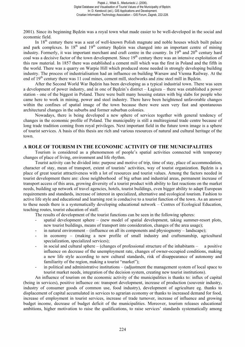
To promote tourist functions in the municipality of Będzin it is required to create a planned and long-term system of conceptions, projects and plans of execution the investment tasks. The first and preliminary stage of any systematical actions in this field should be a clearly description of the resources of natural and cultural values and their classification to make an interactive computer database and its permanent updating.
According to the classification of tourist values established in literature of this topic the authors suggest the following division of the tourist values of Będzin (Kowalczyk, 2002).
Fig. 2. The map of tourist attraction in Będzin (by Absalon i in., 2005)
Piątek J., Witek S., Mieduniecki J. (2006). Digital Database and Visualisation of Tourist Values of the Municipality of Będzin.
In: D. Kereković (ed.). GIS Applications and Development. Croatian Information Technology Association – GIS Forum, Zagreb, 222-228.
226
PROPOSITION OF THE CLASSIFICATION OF TOURIST VALUES OF BĘDZIN Table 1
HERITAGE TOURISM (SIGHTSEEING) VALUES
REST VALUES
NATURAL CULTURAL
SPECIALIST VALUES
• sports and recreational buildings • park areas • forests • open areas
• complex of outlier hills • areas legally protected: areas of protected landscapes, monuments of nature, natural and landscape complexes*, ecological arable lands*
• old ramparts of Łużycka culture, • royal castle, • palace and court complexes, • town planning systems, • monuments, • historical buildings
• Czarna Przemsza river (canoeing trip), • basements in the area of Zamkowe Hill, • horses’ stud, • bicycle routes, • historical buildings: palaces, churches, wayside shrines, historical tenement houses, breweries; • buildings and places of Judaism culture: cemeteries, synagogues, squares, monuments, tenement houses; • buildings of afterindustrial architecture: workers’ housing estates, cement mill, aftermining areas, areas after exploitation; • transport areas: railway stations, unique roundabout, historical railway and tram tractions.
* it is being prepared now INTERACTIVE DATABASE ABOUT TOURIST VALUES OF THE MUNICIPALITY OF BĘDZIN
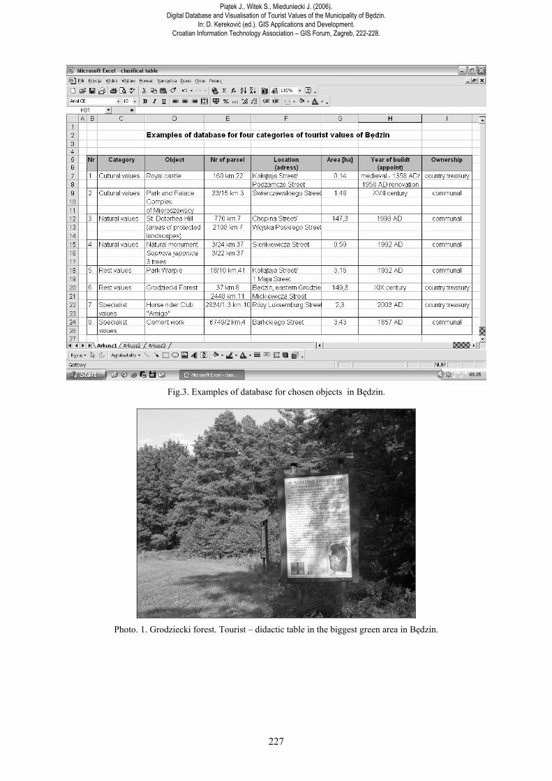
Increasing traffic in national and specialist tourism in Będzin requires from Municipal Town rational management of resources of the natural and cultural environment which are tourist attractions. For the needs of planning and marketing of tourist services, as well as in order to protect landscape values, it is necessary to work out and continuously update a complex database functioning on the GIS platform. Data concerning cataloguing of rest values, natural, cultural and landscape values, and specialist values, as well as data on tourist traffic control in the town, has been and is still being collected.
Piątek J., Witek S., Mieduniecki J. (2006). Digital Database and Visualisation of Tourist Values of the Municipality of Będzin.
In: D. Kereković (ed.). GIS Applications and Development. Croatian Information Technology Association – GIS Forum, Zagreb, 222-228.
227
Fig.3. Examples of database for chosen objects in Będzin.
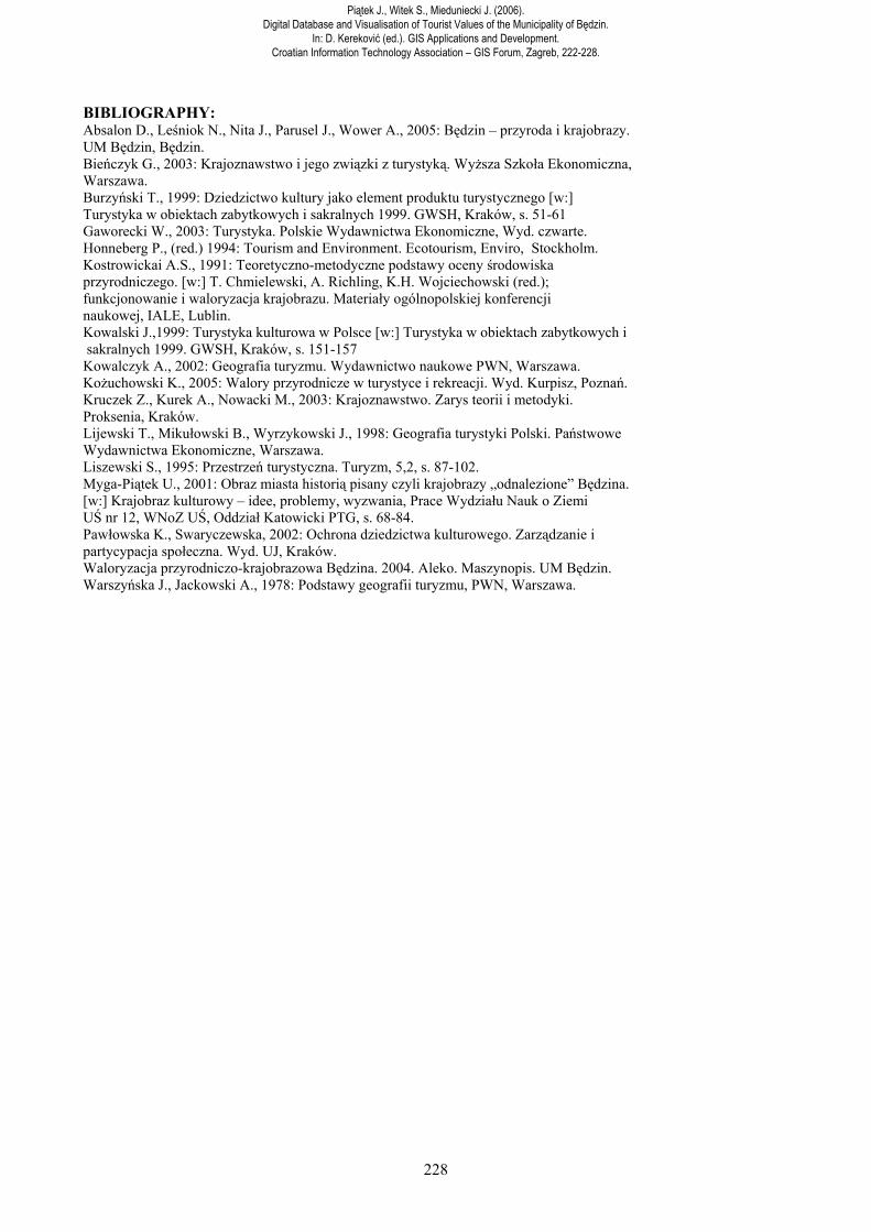
Photo. 1. Grodziecki forest. Tourist – didactic table in the biggest green area in Będzin.
Piątek J., Witek S., Mieduniecki J. (2006). Digital Database and Visualisation of Tourist Values of the Municipality of Będzin.
In: D. Kereković (ed.). GIS Applications and Development. Croatian Information Technology Association – GIS Forum, Zagreb, 222-228.
228
BIBLIOGRAPHY: Absalon D., Leśniok N., Nita J., Parusel J., Wower A., 2005: Będzin – przyroda i krajobrazy. UM Będzin, Będzin. Bieńczyk G., 2003: Krajoznawstwo i jego związki z turystyką. Wyższa Szkoła Ekonomiczna, Warszawa. Burzyński T., 1999: Dziedzictwo kultury jako element produktu turystycznego [w:] Turystyka w obiektach zabytkowych i sakralnych 1999. GWSH, Kraków, s. 51-61 Gaworecki W., 2003: Turystyka. Polskie Wydawnictwa Ekonomiczne, Wyd. czwarte. Honneberg P., (red.) 1994: Tourism and Environment. Ecotourism, Enviro, Stockholm. Kostrowickai A.S., 1991: Teoretyczno-metodyczne podstawy oceny środowiska przyrodniczego. [w:] T. Chmielewski, A. Richling, K.H. Wojciechowski (red.); funkcjonowanie i waloryzacja krajobrazu. Materiały ogólnopolskiej konferencji naukowej, IALE, Lublin. Kowalski J.,1999: Turystyka kulturowa w Polsce [w:] Turystyka w obiektach zabytkowych i sakralnych 1999. GWSH, Kraków, s. 151-157 Kowalczyk A., 2002: Geografia turyzmu. Wydawnictwo naukowe PWN, Warszawa. Kożuchowski K., 2005: Walory przyrodnicze w turystyce i rekreacji. Wyd. Kurpisz, Poznań. Kruczek Z., Kurek A., Nowacki M., 2003: Krajoznawstwo. Zarys teorii i metodyki. Proksenia, Kraków. Lijewski T., Mikułowski B., Wyrzykowski J., 1998: Geografia turystyki Polski. Państwowe Wydawnictwa Ekonomiczne, Warszawa. Liszewski S., 1995: Przestrzeń turystyczna. Turyzm, 5,2, s. 87-102. Myga-Piątek U., 2001: Obraz miasta historią pisany czyli krajobrazy „odnalezione” Będzina. [w:] Krajobraz kulturowy – idee, problemy, wyzwania, Prace Wydziału Nauk o Ziemi UŚ nr 12, WNoZ UŚ, Oddział Katowicki PTG, s. 68-84. Pawłowska K., Swaryczewska, 2002: Ochrona dziedzictwa kulturowego. Zarządzanie i partycypacja społeczna. Wyd. UJ, Kraków. Waloryzacja przyrodniczo-krajobrazowa Będzina. 2004. Aleko. Maszynopis. UM Będzin. Warszyńska J., Jackowski A., 1978: Podstawy geografii turyzmu, PWN, Warszawa.
Piątek J., Witek S., Mieduniecki J. (2006). Digital Database and Visualisation of Tourist Values of the Municipality of Będzin.
In: D. Kereković (ed.). GIS Applications and Development. Croatian Information Technology Association – GIS Forum, Zagreb, 222-228.