2 Steffen Mischke , Ulla Schudack , Sébastien Bertrand ...
19
1 Authors 1 Steffen Mischke 1,2 , Ulla Schudack 2 , Sébastien Bertrand 3,4 , Suzanne A. G. Leroy 4 2 3 1 Institute for Earth and Environmental Sciences, University of Potsdam, 14476 Potsdam, 4 Germany 5 2 Institute of Geological Sciences, Freie Universität Berlin, 12249 Berlin, Germany 6 3 Alfred Wegener Institute for Polar and Marine Research, Marine Geology and Paleontology, 7 27520 Bremerhaven, Germany 8 4 Department of Geography and Earth Sciences and Institute for the Environment, Brunel 9 University, West London, Uxbridge UB8 3PH, UK 10 11 Title 12 Ostracods from a Marmara Sea lagoon (Turkey) as tsunami indicators 13 14 15 Corresponding author: Steffen Mischke ([email protected]) 16 17 18 Key words 19 Marmara Sea; Gulf of İzmit; Ostracoda; lagoon; brackish water; tsunami 20 21
Transcript of 2 Steffen Mischke , Ulla Schudack , Sébastien Bertrand ...
1
Authors 1
Steffen Mischke1,2, Ulla Schudack2, Sébastien Bertrand3,4, Suzanne A. G. Leroy4 2
3
1Institute for Earth and Environmental Sciences, University of Potsdam, 14476 Potsdam, 4
Germany 5
2Institute of Geological Sciences, Freie Universität Berlin, 12249 Berlin, Germany 6
3Alfred Wegener Institute for Polar and Marine Research, Marine Geology and Paleontology, 7
27520 Bremerhaven, Germany 8
4Department of Geography and Earth Sciences and Institute for the Environment, Brunel 9
University, West London, Uxbridge UB8 3PH, UK 10
11
Title 12
Ostracods from a Marmara Sea lagoon (Turkey) as tsunami indicators 13
14
15
Corresponding author: Steffen Mischke ([email protected]) 16
17
18
Key words 19
Marmara Sea; Gulf of İzmit; Ostracoda; lagoon; brackish water; tsunami 20
21
2
Abstract 22
A 352 cm long sediment core from Hersek Lagoon (Gulf of İzmit) was investigated for its 23
ostracod species composition in order to evaluate the potential of ostracods to detect 24
tsunami deposits in coastal environments. The Gulf of İzmit is the eastern bay of the 25
Marmara Sea which is tectonically controlled by the North Anatolian Fault. Ostracod shells 26
are rare in the lower third of the core, which probably represents a coastal wetland 27
environment. According to radiocarbon dating of terrestrial plant remains, this unit was 28
deposited between AD 500 and AD 800. Above, ostracod shells are abundant and 29
dominantly monospecific, composed almost exclusively of the widespread brackish water 30
ostracod Cyprideis torosa. This almost monospecific occurrence indicates the establishment 31
and maintenance of the Hersek Lagoon after AD 800. Three distinct layers of mollusc shells 32
and fragments contain ostracod shells of marine and to a lesser extent non-marine origin in 33
addition to those of Cyprideis torosa. The shell layers are further characterized by significant 34
maxima in total ostracod shell numbers. The high concentration of ostracod shells, the higher 35
species numbers and the mixture of marine, lagoonal and non-marine ostracod shells shows 36
that shell layers were formed as high-energy deposits resulting from tsunamis or large 37
storms in the Marmara Sea. The partial occurrence of non-marine ostracod shells in the shell 38
layers possibly indicates that tsunamis with extensive run-ups and significant backwash flows 39
caused the high-energy deposits rather than large storms. The investigated sediments show 40
that lagoonal ostracods can serve as good proxies for tsunamis or large storms through 41
significant variations in total shell numbers, species numbers and the mixing of shells of 42
different origin. 43
44
1. Introduction 45
Tsunamis and large storms are significant threats to coastal population and infrastructure. 46
Precautionary/mitigation measures were intensively discussed following the devastating 47
tsunami in the Indian Ocean on 26 December 2004, and hurricane Katrina that destroyed 48
3
large parts of New Orleans in August 2005. The risk assessment of specific coastal regions 49
often relies on systematic records of tides and meteorological data although the 50
observational data do not necessarily cover periods of tsunami occurrence. Less systematic 51
records such as historical documents and, eventually, geological evidence is required to 52
obtain longer records for long-term assessment of catastrophic risks by tsunamis and storms 53
(i.e. Leroy et al., 2010). 54
Consequently, several examples of tsunami or storm reconstructions based on geological 55
evidence were presented in recent years (e.g., Leroy et al., 2002; Maramai et al., 2005; 56
Dominey-Howes, 2007; Fujino et al., 2009). Sedimentological features such as erosional 57
contacts, normally graded beds, rip-up clasts or boulders and organism remains were used 58
for the reconstruction of catastrophic flooding as a result of tsunamis or large storms in 59
coastal regions (Dawson and Smith, 2000; Dawson and Stewart, 2007; Morton et al., 2007; 60
Dahanayake and Kulasena, 2008, Donato et al., 2008). Foraminifera and diatom tests are 61
thought to be the most significant biotic indicators for the identification of tsunami and storm 62
deposits (Clague et al., 1999; Dawson and Smith, 2000; Dawson, 2007; Kortekaas and 63
Dawson, 2007; Dahanayake and Kulasena, 2008). In contrast, ostracods, which represent 64
one of the most widespread organism groups that produces readily fossilized remains, have 65
only rarely been used for the recognition of tsunami and storm deposits (Fujiwara et al., 66
2000; Ruiz et al., 2005, 2010; Boomer et al., 2007; Alvarez-Zarikian et al., 2008). Ostracods 67
may however provide more information than foraminifers in coastal water bodies with low 68
salinity or freshwater inflow. In comparison to diatoms, ostracods may be more efficiently 69
used since sample processing is usually less laborious. In addition, the possibility to perform 70
stable isotope and trace element analyses on the calcitic ostracod shells may represent a 71
significant advantage over diatoms and some groups of foraminifers (Frenzel and Boomer, 72
2005). Therefore, we examined the potential of ostracods as indicators of tsunamis and large 73
storms using a sediment core from Hersek Lagoon at the southeastern Marmara Sea shore 74
4
(Gulf of İzmit, Turkey). Additional results and those of other cores from the lagoon are 75
presented in a separate paper by Bertrand et al. (submitted). 76
77
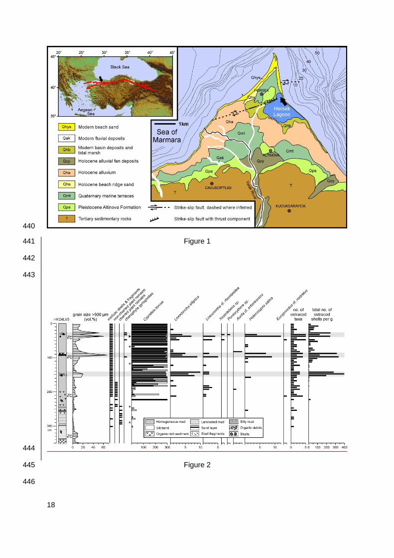
2. Study area 78
Hersek Lagoon is located on a northward-prograding delta (Hersek Delta or Hersek 79
Peninsula) in the Gulf of İzmit of the eastern Marmara Sea (Turkey, Fig. 1). The area of the 80
lagoon is 1.4 km² and the water depth ranges between 0.3 and 0.7 m. The salinity is 28-30 81
P.S.U. in most parts of the lagoon, and 38-40 P.S.U. at its northwestern margin. The lagoon 82
is separated from the sea by a narrow sand ridge reinforced by a concrete dike in the last 83
century. The topography in the vicinity of the lagoon is flat (2-3 m above sea level [asl]) 84
except for a prominent hill of uplifted Pleistocene marine sediments at the northern tip of the 85
peninsula (Fig. 1). The climate is characterized by dry summers and mild and rainy winters. 86
The Gulf of İzmit is the eastern extension of the Marmara Sea, which connects the 87
Mediterranean Sea in the south to the Black Sea in the north. The water in the Marmara Sea 88
is permanently stratified, with a halocline at 20-25 m depth. Less saline (salinity: 18) surface 89
water of the Black Sea flows to the Aegean Sea and saline bottom water (38) flows in the 90
opposite direction (Ünlüatu et al., 1990). Water depth in the western and central Gulf of İzmit 91
basins near the Hersek Peninsula reaches ca 200 m but does not exceed 50 m in the close 92
vicinity of the delta (Dolu et al., 2007; Fig. 1). 93
The tectonic setting in the Marmara Sea region is mainly controlled by the North Anatolian 94
Fault Zone (NAFZ), which is one of the longest and most active strike-slip faults in the world 95
(Fig. 1). The NAFZ runs roughly parallel to the Black Sea coast of Anatolia and splits into two 96
strands in its western part (Fig. 1). The northern strand passes through the Gulf of İzmit and 97
Hersek Lagoon (Yalova fault segment) and runs further through the Marmara Sea, 98
representing the source of numerous large historical earthquakes (Dolu et al., 2007; Fig. 1). 99
The most recent major earthquake of the NAFZ (17 August 1999) triggered surface ruptures 100
5
including vertical displacements, submarine slumps and eventually a devastating tsunami in 101
the Gulf of İzmit (Tinti et al., 2006). 102
103
3. Materials and methods 104
Ten cores were obtained with a Livingstone piston corer from an anchored raft in Hersek 105
Lagoon. Core HK04LV5 (40.724°N, 29.519°E, 0.47 m water depth), which is one of the 106
longest cores collected and the only one from a position north of the Yalova segment of the 107
North Anatolian Fault, was selected for ostracod analysis. 108
Samples of about 65 g were collected continuously from 5 cm segments of a core half for 109
ostracod analysis and sieved with 500, 250 and 63 µm meshes. Absolute ostracod shell 110
abundances and the presence of mollusc shells and fragments, and charred and non-111
charred plant remains were determined with a low-power binocular microscope. Up to 300 112
ostracod shells were counted and picked from the sieve residues of the >250 µm fraction. 113
For samples containing more than 300 shells, randomly selected subsamples of the 114
remaining sieve residue material were used for further counting and total shell abundances 115
were then calculated by extrapolation. Identification of ostracod species mainly followed 116
Athersuch et al. (1989). Shells of the less frequent species were only identified with 117
reservation due to their low numbers and occurrence at juvenile stages. 118
Grain size was estimated by measuring the volume of sediment in the fractions obtained 119
after sieving at 500, 250 and 63 µm. 120
Radiocarbon dating was performed on terrestrial plant remains from four stratigraphic levels 121
(334-329 cm, 215-210 cm, 102.5-97.5 cm, 45-40 cm; Fig. 2). Samples were analyzed at the 122
Poznan Radiocarbon Laboratory, Poland, and the radiocarbon ages were calibrated with 123
OxCal 4.0 using the IntCal04 calibration curve (Reimer et al., 2004). 124
125
4. Results 126
6
Radiocarbon dating yielded the following ages: 1590 ± 80 14C a BP at 334-329 cm, 1230 ± 60 127
14C a BP at 215-210 cm, 1190 ± 30 14C a BP at 102.5-97.5 cm and 1235 ± 35 14C a BP at 45-128
40 cm. The corresponding weighted averages of calibrated ages are AD 511, 792, 834 and 129
777, respectively. 130
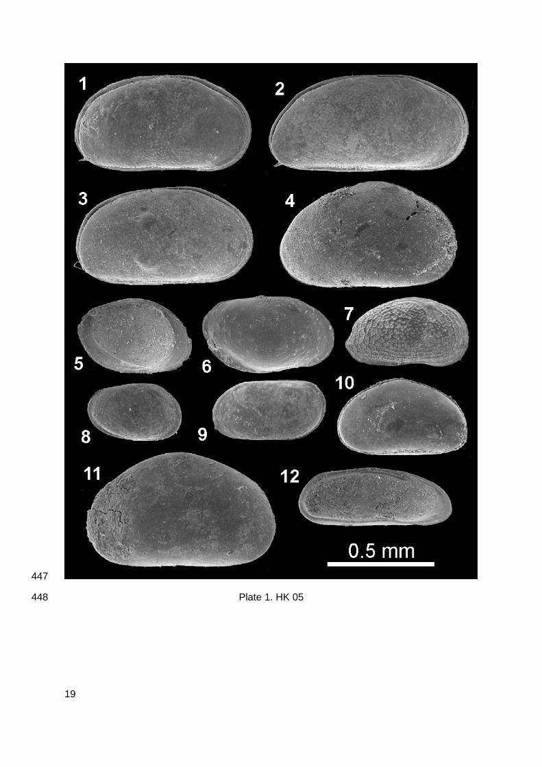
Recovered sediments mainly comprise homogenous mud (Fig. 2). Laminations, organic-rich 131
sediments, and four distinct sand layers occur in the lower third of the core. Three layers of 132
brackish-marine mollusc shells and fragments were recorded in the upper half of the core. 133
The grain size fraction <63 µm predominates with a mean proportion of 77 %. The fractions 134
63-250 µm, 250-500 µm, and >500 µm have mean proportions of 10 %, 4 % and 9 %. The 135
finest (<63 µm) and coarsest (>500 µm) fractions have a relatively large variability compared 136
to the intermediate fractions (Fig. 2). Grain size changes are only shown for the > 500 µm 137
fraction since the 63-250 µm and 250-500 µm fractions are relatively stable, and the <63 µm 138
fraction shows an opposite but otherwise similar trend (Fig. 2). 139
Ostracod shells are almost absent from the lower part of the core but abundant in its upper 140
half (Fig. 2). Shells of Cyprideis torosa clearly predominate whereas those of Loxoconcha 141
elliptica, L. cf. rhomboidea and Heterocypris salina are restricted to a number of stratigraphic 142
levels (Fig. 2, Plate 1). All shells of Cyprideis torosa belong to the smooth form Cyprideis 143
torosa forma littoralis apart from a single noded shell (Cyprideis torosa forma torosa) 144
recorded at 40-35 cm depth (Fig. 2, Plate 1). Those of Pontocythere sp., Aurila cf. 145
arborescens, Eucyprinotus cf. rostratus display a more erratic occurrence. Total numbers of 146
ostracod taxa and total shell concentrations peak at three levels in the core: 153-142 cm, 98-147
87 cm and 38-27 cm (Fig. 2). 148
Mollusc shells and fragments occur in all samples above 213 cm, charred plant remains 149
occur between 294 and 242 cm, and non-charred plant remains were observed between 243 150
and 172 cm (Fig. 2). Charophyte gyrogonites were recorded at 97 and 47 cm core depth, and 151
in two adjoining samples at 32 and 27 cm (Fig. 2). 152
153
7
5. Discussion and conclusion 154
Calibrated ages of the four samples analyzed for radiocarbon indicate that the sediment was 155
deposited between ca AD 500 and 800. The upper three samples yielded virtually identical 156
ages, most likely reflecting particularly high accumulation rates in at least the upper 215 cm 157
of the core. Alternatively, the incorporation, transportation and accumulation of aged 158
terrestrial organic matter of similar source over a longer period of time could have caused the 159
similar age results for the upper three 14C samples. 160
The most striking feature of the core from Hersek Lagoon is the predominance of ostracod 161
shells of Cyprideis torosa in its upper 185 cm. Cyprideis torosa is a widespread inhabitant of 162
brackish coastal waters of the northern hemisphere with a salinity tolerance ranging from 163
almost pure freshwater to hyperhaline conditions (Meisch, 2000). Cyprideis torosa is the 164
most abundant species in the Baltic Sea (Frenzel and Boomer, 2005) and it often inhabits 165
lagoons and estuaries of the Mediterranean Sea alone and at high concentrations (Meisch, 166
2000; Ruiz et al., 2000). It was the only species recorded in all of the eight lagoons of Turkey 167
examined by Altinsaçli (2004) including two lagoons of the Marmara Sea coast. Furthermore, 168
it frequently occurs in brackish continental waters in northern Africa, the Near East and 169
Central Asia (Meisch, 2000; Mischke et al., 2010). Although commonly occurring in the 170
present Marmara Sea and the Gulf of İzmit, Cyprideis torosa seldom predominates (Kubanç 171
et al., 1999; Kubanç, 2005). Its dominance in the recovered sediments is evidence that 172
Hersek lagoon was separated from the Marmara Sea during the period represented by the 173
middle and upper part of the core. 174
In contrast, the lowermost part of the core (352-223 cm) is characterized by only sporadic 175
occurrences of ostracod and mollusc shells in low numbers, and more silty and organic-rich 176
sediments with charred plant remains probably representing a coastal wetland environment. 177
Sediment samples between 223 and 172 cm all contain shells of Cyprideis torosa although in 178
low numbers, mollusc shells and fragments, and non-charred instead of charred plant 179
remains, probably representing the establishment of a lagoon with a high sediment influx 180
8
during its initial stage. This interpretation is supported by geochemical data from the core 181
(Bertrand et al., submitted). 182
Three distinct layers of brackish-marine mollusc shells and fragments occur at ca 150, 90 183
and 30 cm core depth, within the homogenous mud that composes the upper part of the core 184
(Fig. 2). All three shell layers contain shells of Loxoconcha elliptica and Loxoconcha cf. 185
rhomboidea beyond those of Cyprideis torosa. In addition, a few more erratically occurring 186
ostracod species are apparently confined to these shell layers (Fig. 2, Plate 1). The ostracod 187
shell concentration reaches three pronounced maxima corresponding to increases in the 188
number of ostracod taxa in the shell layers. Loxoconcha elliptica is a typical brackish water 189
species inhabiting estuaries, lagoons and pools, commonly associated with algae and mud 190
(Athersuch et al., 1989). Loxoconcha rhomboidea is a predominant species in the near-shore 191
waters of the southern Marmara Sea and other species of Loxoconcha, Aurila and 192
Xestoleberis occur in this region too (Kubanc, 2005). Furthermore, Loxoconcha rhomboidea 193
and other species of Loxoconcha, Xestoleberis sp., Pontocythere sp. and P. elongata, and 194
Aurila sp. were recovered from Pleistocene marine sediments in the Gulf of İzmit in the north 195
of Hersek Peninsula. Thus, shells of Loxoconcha rhomboidea, Xestoleberis, Pontocythere 196
and Aurila in the Hersek Lagoon sediments probably originate from the Gulf of İzmit section 197
of the Marmara Sea. 198
In contrast, Heterocypris salina and Eucyprinotus cf. rostratus are typical non-marine 199
ostracod species (Fig. 2, Plate 1). Heterocypris salina is an abundant inhabitant of small 200
slightly brackish coastal water bodies of the Baltic and North Sea and small inland water 201
bodies, and it generally occurs where salinity is <10 (Meisch, 2000). Accordingly, the specific 202
conductivity tolerance of Heterocypris salina ranges between 2.8 and 8.2 mS cm-1 and 0.7 203
and 5.9 mS cm-1, as determined from the occurrence of this species in 37 water bodies in 204
Israel and at 43 sites in Spain, respectively (Mezquita et al., 2005; Mischke et al., 2010). 205
Eucyprinotus rostratus was recorded from few freshwater sites in Europe, Turkey and the 206
Near East (Martens et al., 1992, 2002; Martens and Ortal, 1999; Eitam et al., 2004; Tunoğlu 207
9
and Ertekin, 2008; Mischke et al., 2010). We assume that the few shells of Heterocypris 208
salina and Eucyprinotus cf. rostratus originated from small fresh to slightly brackish water 209
bodies on the Hersek Peninsula. Three out of four samples containing charophyte 210
gyrogonites correspond to the upper two shell layers (Fig. 2). Although charophytes may 211
occur at relatively high salinities too, the coinciding occurrence of the non-marine ostracods 212
and the charophyte remains suggests that the gyrogonites were probably transported from 213
more marginal, less brackish positions in the lagoon or from small fresh to slightly brackish 214
water bodies on the peninsula. 215
The simultaneous occurrence of ostracods of different origin (lagoonal: C. torosa and 216
Loxoconcha elliptica; shallow marine: L. rhomboidea, Xestoleberis sp., Pontocythere sp. and 217
Aurila cf. arborescens; and inland waters: H. salina and E. cf. rostratus) within beds of 218
brackish-marine mollusc shells and fragments indicates that the shell layers were deposited 219
under high-energy environmental conditions (Ruiz et al., 2010). In the case of Lake Manyas 220
(140 km west of Hersek Lagoon), ostracods of different origins also are interpreted as 221
reflecting an event of large amplitude (seiche) leading to a spatially averaged snapshot of 222
regional assemblages (Leroy et al., 2002). 223
The shell layers are separated by homogenous mud of ca 40 cm thickness suggesting three 224
distinct events. Tsunamis or large storms are the two main processes which may have 225
turned the sheltered setting of Hersek lagoon into a high-energy depositional environment. 226
The occurrence of shells of two species from only slightly brackish or even freshwater 227
habitats implies that there was not only a landward transport of marine ostracod shells but 228
also a seaward transport of non-marine shells. Since tsunamis have generally a larger inland 229
extent than storms (Dawson and Stewart, 2007; Kortekaas and Dawson, 2007), we assume 230
that the shallow marine ostracod shells were transported to Hersek Lagoon during the run-up 231
phase and the non-marine ostracod shells during the backwash phase of tsunamis although 232
this differentiation between tsunamis and large storms as the triggering processes for the 233
high-energy deposits in Hersek Lagoon remains speculative. 234
10
Alternatively, the occurrence of ostracod shells from inland waters in Hersek lagoon could be 235
explained by transport and deposition from the Yalak River (Fig. 1). There are however four 236
arguments against this assumption: (1) the present disconnection between the Yalak River 237
and Hersek Lagoon existed apparently during the entire period covered by the investigated 238
core and additional cores from the Hersek Lagoon as revealed from clay mineral analysis by 239
Bertrand et al. (submitted), (2) there is no evidence for the delivery of terrestrial plant matter 240
occurring as charred or non-charred plant remains within the three shell beds, (3) the > 500 241
µm grain size fraction shows rapid changes associated with the shells beds rather than 242
gradual changes expected for the accumulation of more proximal or distal delta sediments in 243
a lagoon, and (4) the occurrence of especially Heterocypris salina in somewhat higher 244
abundances apparently coincides systematically with the occurrence of the shallow marine 245
ostracods in the core. Thus, delivery of the non-marine ostracod shells by the Yalakdere to 246
the core site is unlikely. 247
In addition, transport to the core site of non-marine ostracod shells originating from the 248
erosion of Quaternary sediments of Hersek Peninsula is regarded as an unlikely process due 249
to the intense weathering of the exposed Quaternary sediments and to the expected poor 250
preservation or destruction of the fragile calcitic ostracods shells. The recorded non-marine 251
ostracod shells do not display a difference in shell preservation in comparison to the shells 252
with lagoonal and shallow marine origins. Although the incorporation of non-marine ostracod 253
shells from eroded Quaternary sediments cannot completely be ruled out based on the 254
available data, we do not consider this scenario as a realistic option. 255
The inferred shift from a coastal wetland to a lagoon in ca AD 800 probably resulted from 256
coseismic subsidence of part of the Hersek Peninsula, which was most likely triggered by the 257
historically documented AD 740 earthquake with a magnitude of 7.1 in the Marmara Sea 258
region (Ambraseys, 2002). This inference and results from additional cores in Hersek lagoon 259
are presented in Bertrand et al. (submitted). Three further earthquakes with magnitudes ≥6.8 260
were documented in AD 823, 860 and 869 (Ambraseys, 2002). However, the lack of 261
11
historical records for earthquake-induced tsunamis and the insufficient precision of our age-262
depth model does not allow an unequivocal assignment of the three shell beds to these 263
earthquakes. 264
To conclude, our study of Hersek Lagoon sediments exemplified the great potential of 265
ostracods as indicators of tsunamis or large storms through several lines of evidence: (1) the 266
large number of ostracod shells accumulated during the high-energy events, (2) the higher 267
number of taxa which is not typical for an undisturbed lagoon setting, and (3) the mixture of 268
ostracod shells with clear marine, lagoonal and non-marine origins, i.e. spatial average. This 269
last criterion might help to differentiate between tsunami and storm deposits in appropriate 270
coastal settings with near-shore water bodies. 271
272
Acknowledgements 273
Funding was provided by the European Union in the framework of the REL.I.E.F. (RELiable 274
Information on Earthquake Faulting) project (EVG1-CT-2002-00069). We are grateful to Lisa 275
Doner and Serdar Aykuz (both Istanbul Technical University), Pedro Costa (Brunel 276
University), Salim Öncel (Gebze Institute of Technology), Özden Ileri and Fatih Uysal 277
(Ankara University) for assistance during our fieldwork expeditions in Turkey, to Lina Mehta, 278
Vanessa Tomasz and Paul Szadorsky for laboratory assistance at Brunel University, and to 279
Nerdin Kubanç for comments with respect to Loxoconcha elliptica specimens. We would also 280
like to thank Peter Frenzel and an anonymous reviewer for critical and very helpful 281
comments on a previous version of this manuscript, and Norm Catto for editorial help. 282
283
References 284
Altinsaçli, S., 2004. Investigation on Ostracoda (Crustacea) fauna of some important 285
wetlands of Turkey. Pakistan Journal of Biological Sciences 7, 2130-2134. 286
12
Alvarez-Zarikian, C.A., Soter, S., Katsonopoulou, D., 2008. Recurrent submergence and 287
uplift in the area of ancient Helike, Gulf of Corinth, Greece: Microfaunal and 288
archaeological evidence. Journal of Coastal Research 24, 110-125. 289
Ambraseys, N., 2002. The seismic activity of the Marmara Sea region over the last 2000 290
years. Bulletin of the Seismological Society of America 92, 1-18. 291
Athersuch, J., Horne, D.J., Whittaker, J.E., 1989. Marine and Brackish Water Ostracods. In: 292
Kermack, D.M., Barnes, R.S.K. (Eds.), Synopsis of the British Fauna (New Series), 43, 293
343 pp. 294
Bertrand, S., Doner, L., Cagatay, N., Akcer, S., Sancar, U., Schudack, U., Mischke, S., 295
Leroy, S. Sedimentary record of coseismic subsidence in Hersek coastal lagoon (İzmit 296
Bay, Turkey) and the late Holocene activity of the North Anatolian Fault. submitted to 297
Geochemistry, Geophysics, Geosystems Now where? 298
Boomer, I., Waddington, C., Stevenson, T., Hamilton, D., 2007. Holocene coastal change 299
and geoarchaeology at Howick, Northumberland, UK. The Holocene 17, 89-104. 300
Clague, J.J., Hutchinson, I., Mathewes, R.W., Patterson, R.T., 1999. Evidence for late 301
Holocene tsunamis at Catala Lake, British Columbia. Journal of Coastal Research 15, 45-302
60. 303
Dahanayake, K., Kulasena, N., 2008. Recognition of diagnostic criteria for recent- and paleo-304
tsunami sediments from Sri Lanka. Marine Geology 254, 180-186. 305
Dawson, A.G., Stewart, I., 2007. Tsunami deposits in the geological record. Sedimentary 306
Geology 200, 166-183. 307
Dawson, S., 2007. Diatom biostratigraphy of tsunami deposits: Examples from the 1998 308
Papua New Guinea tsunami. Sedimentary Geology 200, 328-335. 309
Dawson, S., Smith, D.E., 2000. The sedimentology of Middle Holocene tsunami facies in 310
northern Sutherland, Scotland, UK. Marine Geology 170, 69-79. 311
Dolu, E., Gökaşan, E., Meriç, E., Ergin, M., Görüm, T., Tur, H., Ecevitoğlu, B., Avşar, N., 312
Görmüş, M., Batuk, F., Tok, B., Çetin, O., 2007. Quaternary evolution of the Gulf of İzmit 313
13
(NW Turkey): A sedimentary basin under control of the North Anatolian Fault Zone. Geo-314
Marine Letters 27, 355-381. 315
Dominey-Howes, D., 2007. Geological and historical records of tsunami in Australia. Marine 316
Geology 239, 99-123. 317
Donato, S.V., Reinhardt, E.G, Boyce, J.I, Rothaus, R., Vosmer, T., 2008. Identifying tsunami 318
deposits using bivalve shell taphonomy. Geology 36, 199-202. 319
Eitam, A., Blaustein, L., Van Damme, K., Dumont, H.J., Martens, K., 2004. Crustacean 320
species richness in temporary pools: relationships with habitat traits. Hydrobiologia 525, 321
125-130. 322
Frenzel, P., Boomer, I., 2005. The use of ostracods from marginal marine, brackish waters 323
as bioindicators of modern and Quaternary environmental change. Palaeogeography, 324
Palaeoclimatology, Palaeoecology 225, 68-92. 325
Fujino, S., Naruse, H., Matsumoto, D., Jarupongsakul, T., Sphawajruksakul, A., Sakakura, 326
N., 2009. Stratigraphic evidence for pre-2004 tsunamis in southwestern Thailand. Marine 327
Geology 262, 25-28. 328
Fujiwara, O., Masuda, F., Sakai, T., Irizuki, T., Fuse, K., 2000. Tsunami deposits in Holocene 329
bay mud in southern Kanto region, Pacific coast of central Japan. Sedimentary Geology 330
135, 219-230. 331
Kortekaas, S., Dawson, A.G., 2007. Distinguishing tsunami and storm deposits: An example 332
from Martinhal, SW Portugal. Sedimentary Geology 200, 208-221. 333
Kozaci, Ö., 2002. Hersek deltasi’nda Kuzey Anadolu fayi’nin Yalova segmenti üzerinde 334
paleosismolojik calismalar. Unpublished bachelor thesis, Istanbul Technical University, 335
Turkey. 336
Kubanç, C., Meriç, E., Gülen, D., 1999. Urocythereis britannica Athersuch'nın İzmit Körfezi 337
(KB Türkiye) Pleyistosen'inde Bulunuşu Üzerine. Turkish Journal of Zoology 23, 791-799. 338
Kubanç, S.N., 2005. Diversity and comparison of Ostracoda of South Marmara Sea. Journal 339
of the Black Sea/Mediterranean Environment 11, 257-275. 340
14
Kuşçu, I., Okamura, M., Matsuoka, H., Awata, Y., 2002. Active faults in the Gulf of 341
İzmit on the North Anatolian Fault, NW Turkey: A high-resolution shallow seismic 342
study. Marine Geology 190, 421-443. 343
Leroy, S., Kazancı, N., Ileri, Ö., Kibar, M., Emre, O., McGee, E., Griffiths, H.I., 2002. Abrupt 344
environmental changes within a late Holocene lacustrine sequence south of the Marmara 345
Sea (Lake Manyas, N-W Turkey): possible links with seismic events. Marine Geology 190, 346
531-552. 347
Leroy, S.A.G., Warny, S., Lahijani, H., Piovano, E., Fanetti, D., Berger, A.R., 2010. The role 348
of geosciences in the improvement of mitigation of natural disasters: five case studies. In: 349
Beer, T. (Ed.), Geophysical Hazards: Minimising risk, maximising awareness. Springer 350
Science series International Year of Planet Earth, pp. 115-147. 351
Lettis, W., Bachluber, J., Witter, R., Brankman, C., Randolph, C.E., Barka, A., Page, W.D., 352
Kaya, A., 2002. Influence of releasing step-overs on surface fault rupture and fault 353
segmentation: Examples from the 17August 1999 Izmit earthquake on the North Anatolian 354
Fault, Turkey. Bulletin of the Seismological Society of America 92, 19-42. 355
Maramai, A., Graziani, L., Tinti, S., 2005. Tsunamis in the Aeolian Islands (southern Italy): a 356
review. Marine Geology 215, 11-21. 357
Martens, K., Ortal, R., 1999. Diversity and zoogeography of inland-water Ostracoda 358
(Crustacea) in Israel (Levant). Israel Journal of Zoology 45, 159-173. 359
Martens, K., Ortal, R., Meisch, C., 1992. The ostracod fauna of Mamilla Pool (Jerusalem, 360
Israel) (Crustacea, Ostracoda). Zoology in the Middle East 7, 95-114. 361
Martens, K., Schwartz, S.S., Meisch, C., Blaustein, L., 2002. Non-marine Ostracoda 362
(Crustacea) of Mount Carmel (Israel), with taxonomic notes on Eucypridinae and circum-363
mediterranean Heterocypris. Israel Journal of Zoology 48, 53-70. 364
Meisch, C., 2000. Freshwater Ostracoda of Western and Central Europe. Spektrum, 365
Heidelberg, 522 pp. 366
15
Mezquita, F., Roca, J.R., Reed, J.M., Wansard, G., 2005. Quantifying species–environment 367
relationships in non-marine Ostracoda for ecological and palaeoecological studies: 368
Examples using Iberian data. Palaeogeography, Palaeoclimatology, Palaeoecology 225, 369
93-117. 370
Mischke, S., Almogi-Labin, A., Ortal, R., Schwab, M.J., Boomer, I., 2010. Quantitative 371
reconstruction of lake conductivity in the Quaternary of the Near East (Israel) using 372
ostracods. Journal of Paleolimnology 43, 667-688. 373
Morton, R.A., Gelfenbaum, G., Jaffe, B.E., 2007. Physical criteria for distinguishing sandy 374
tsunami and storm deposits using modern examples. Sedimentary Geology 200, 184-207. 375
Özaksoy, V., Emre, Ö., Yıldırım, C., Doğan, A., Özalp, S., Tokay, F., 2010. 376
Sedimentary record of late Holocene seismicity and uplift of Hersek restraining 377
bend along the North Anatolian Fault in the Gulf of İzmit. Tectonophysics 487, 33-378
45. 379
Reimer, P.J., Baillie, M.G.L., Bard, E., Bayliss, A., Beck, J.W., Bertrand, C.H.J., Blackwell, 380
P.G., Buck, C.E., Burr, G.S., Cutler, K.B., Damon, P.E., Edwards, R.L., Fairbanks, R.G., 381
Friedrich, M., Guilderson, T.P., Hogg, A.G., Hughen, K.A., Kromer, B., McCormac, G., 382
Manning, S., Bronk Ramsey, C., Reimer, R.W., Plicht, J.v.d., Weyhenmeyer, C.E., 2004. 383
IntCal04 terrestrial radiocarbon age calibration, 0–26 cal kyr BP. Radiocarbon 46, 1029-384
1058. 385
Ruiz, F., Abad, M., Cáceres, L.M., Vidal, J.R., Carretero, M.I., Pozo, M., Gonzáles-Regalado, 386
M.L., 2010. Ostracods as tsunami tracers in Holocene sequences. Quaternary Research 387
73, 130-135. 388
Ruiz, F., Gonzáles-Regalado, M.L., Baceta, J.I., Menegazzo-Vitturi, L., Pistolato, M., 389
Rampazzo, G., Molinaroli, E., 2000. Los ostrácodos actuales de la laguna de Venecia (NE 390
de Italia). Geobios 33, 447-454. 391
Ruiz, F., Rodríguez-Ramírez, A., Cáceres, L.M., Vidal, J.R., Carretero, M.I., Abad, M., Olías, 392
M., Pozo, M., 2005. Evidence of high-energy events in the geological record: Mid-393
16
Holocene evolution of the southwestern Donana National Park (SW Spain). 394
Palaeogeography, Palaeoclimatology, Palaeoecology 229, 212-229. 395
Tinti, S., Armigliato, A., Manucci, A., Pagnoni, G., Zaniboni, F., Yalçiner, A.C., Altinok, Y., 396
2006. The generating mechanisms of the August 17, 1999 Izmit bay (Turkey) tsunami: 397
Regional (tectonic) and local (mass instabilities) causes. Marine Geology 225, 311-330. 398
Tunoğlu, C., Ertekin, I.K., 2008. Subrecent Ostracoda associations and the environmental 399
conditions of karstic travertine bridges on the Zamantý River, southern Turkey. Türkiye 400
Jeoloji Bülteni (Geological Bulletin of Turkey) 51, 151-171. 401
Ünlüatu, Ü., Oğuz, T., Latif, M.A., Özsoy, E., 1990. On the physical oceanography of the 402
Turkish Straits. In: Pratt, L.J. (Ed.), The Physical Oceanography of Sea Straits. Kluwer, 403
Dordrecht, pp. 25-60. 404
Witter, R., Lettis, W., Bachhuber, J., Barka, A., Evren, E., Cakir, Z., Page, D., Hengesh, J., 405
Seitz, G., 2000. Paleoseismic Trenching Study Across the Yalova Segment of the North 406
Anatolian Fault, Hersek Peninsula, Turkey. In: Barka, A., Kazaci, O., Akyüz, S., Altunel, E. 407
(Eds.), The 1999 Izmit and Düzce Earthquakes: Preliminary Results. Istanbul Technical 408
University, Turkey, pp. 329-339. 409
410
411
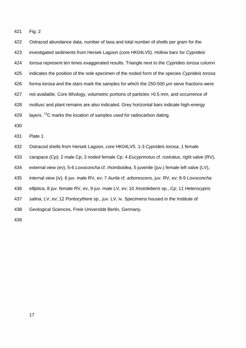
Figure and plate captions 412
Fig. 1 413
Location of the coring site in Hersek Lagoon (arrow) at the northeastern side of Hersek 414
Delta/Peninsula. The study area is part of the Marmara Sea (inset), which is crossed by the 415
northern strand of the North Anatolian Fault (red lines).Geological units are represented 416
according to Witter et al. (2000) and Kozaci (2002), bathymetrical information according to 417
Lettis et al. (2002), and fault locations according to Kuşçu et al. (2002) and Özaksoy et al. 418
(2010). Figure modified from Bertrand et al (submitted). 419
420
17
Fig. 2 421
Ostracod abundance data, number of taxa and total number of shells per gram for the 422
investigated sediments from Hersek Lagoon (core HK04LV5). Hollow bars for Cyprideis 423
torosa represent ten times exaggerated results. Triangle next to the Cyprideis torosa column 424
indicates the position of the sole specimen of the noded form of the species Cyprideis torosa 425
forma torosa and the stars mark the samples for which the 250-500 µm sieve fractions were 426
not available. Core lithology, volumetric portions of particles >0.5 mm, and occurrence of 427
mollusc and plant remains are also indicated. Grey horizontal bars indicate high-energy 428
layers. 14C marks the location of samples used for radiocarbon dating. 429
430
Plate 1 431
Ostracod shells from Hersek Lagoon, core HK04LV5. 1-3 Cyprideis torosa, 1 female 432
carapace (Cp); 2 male Cp; 3 noded female Cp; 4 Eucyprinotus cf. rostratus, right valve (RV), 433
external view (ev); 5-6 Loxoconcha cf. rhomboidea, 5 juvenile (juv.) female left valve (LV), 434
internal view (iv); 6 juv. male RV, ev; 7 Aurila cf. arborescens, juv. RV, ev; 8-9 Loxoconcha 435
elliptica, 8 juv. female RV, ev, 9 juv. male LV, ev; 10 Xestoleberis sp., Cp; 11 Heterocypris 436
salina, LV, ev; 12 Pontocythere sp., juv. LV, iv. Specimens housed in the Institute of 437
Geological Sciences, Freie Universität Berlin, Germany. 438
439
18
440
Figure 1 441
442
443
444
Figure 2 445
446
19
447
Plate 1. HK 05 448