See the Baltic Sea - BEF
82
See the Baltic Sea Unique assets we share
Transcript of See the Baltic Sea - BEF
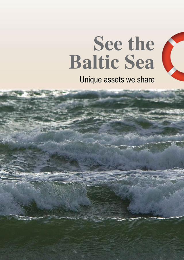
See theBaltic Sea
Unique assets we share

See theBaltic Sea
Unique assets we share
Baltic Environmental Forum
Riga 2009

See the Baltic Sea. Unique assets we share
See the Baltic Sea. Unique assets we share.
Authors: Anda Ruskule, Merle Kuris, Gustina Leiputė, Markus Vetemaa and Šarūnas Zableckis
Chief Editor: Anda Ruskule Editor assistant: Ilze KalvāneEditorial team: Edgars Bojārs, Heidrun Fammler, Merle Kuris, Gustina Leiputė, Žymantas Morkvėnas, Kęstutis Navickas, Antra Stīpniece, Solvita Strāķe
Language editing: Robert Oetjen, Marguerite Oetjen
Design and layout: Katrīna Vasiļevska
Printed in Estonia by Tallinna Raamatutrükikoda Publishedby:Baltic Environmental Forum – Latvia (BEF-Latvia)Doma laukums 1, Riga, LV-1050, LatviaTel: +371 6735 7555Fax: +371 6750 7071www.bef.lv
Copyright ©: (2009) Baltic Environmental Forum - LatviaISBN 978-9984-9898-6-0
Printed on 100% recycled paper
Prepared within in the framework of the LIFE Nature project “Marine Protected Areas in the Eastern Baltic Sea” (LIFE05NAT/LV/000100)
Prepared and printed with a contribution from the LIFE financial instrument of the European Community. The content of this publication is the sole responsibility of the Baltic Environmental Forum and can in no way be taken to reflect the views of the European Union.
�See the Baltic Sea. Unique assets we share
Foreword Dear reader,
You have probably visited the Baltic Sea more than once and have had the pleasure swimming, sun bathing, relaxing during a romantic sunset or even fishing. Or maybe you see the Sea every working day while harvesting its resources, which are so important for all of us. Life near the sea has been busy for many hundreds of years and has been important not only for economic reasons, but also has become part of long–living traditions, some of which can still be observed and experienced.
Today the Baltic Sea is one of the busiest seas of the world with a high frequency of ship traffic, but also a high population in the catchment area along its coast. Large rivers from highly industri-alized countries flow into it and many people enjoy it for recreation. It hosts a variety of economic activities and provides income for those who work on and around it.
At the same time the Baltic Sea is a unique ecosystem. There are special geographic and hy-dromorphological conditions that make it so. The Baltic Sea is connected to the ocean through extremely narrow Danish Belts which hinder the water exchange. Therefore, unlike most other oceans and seas, salinity here is very low resulting in an extraordinary mixture of marine and freshwater species that have adapted their lives to these special conditions. But the same condi-tions also make the species and habitats extremely vulnerable to changes in ecological conditions. In short, the Baltic Sea is a fragile ecosystem and needs our attention and protection.
Unfortunately, the Baltic Sea is among the most polluted seas in the world. Europeans commonly agree that it is a major environmental problem. Measures have been undertaken for more than 30 years to reduce pollution resulting from present and future human activities and to clean up, as far possible, long–standing contamination. Although improvements can be observed, it remains a major task to find a balance between the protection of this fragile ecosystem and the sea’s nu-merous and divergent economic uses. Still, all the efforts will not bring the desired result without public understanding and awareness about our Sea’s value to nature, the threats and conservation measures needed.
With this book, co–financed by the European Commission’s LIFE programme and a variety of donors and partners from seven countries, we want to contribute to the illumination of the Bal-tic Sea and to the understanding of its specific ecosystem. Although this book holds just a tiny glimpse of solid scientific work carried out by the project, we hope it will give you a comprehen-sive overview of the diversity and teeming life of the Baltic Sea.
Enjoy reading the book and See the Sea from a different perspective!
HeidrunFammlerProject manager

� See the Baltic Sea. Unique assets we share
© Photocredits: Page 8: Žymantas Morkvėnas; Page 12: Reda Bernotaitė; Vadims Jermakovs; Page 14, 15: Žymantas Morkvėnas; Page 16: Anda Ruskule; Page 17: Heiko Kruusi; Page 19: Darius Daunys; Page 22: Romas Povilaitis; Julius Morkūnas; Page 23: Eugenijus Kavaliauskas; Fund of Lithuanian Sea Museum, Saulius Karalius; Page 24: Fund of Lithuanian Sea Museum, Saulius Karalius; Page 25: Fund of Lithuanian Sea Museum, Saulius Karalius; Page 27, 28: Markus Vetemaa; Page 31: Martynas Bučas; Page 32, 33: Darius Daunys; Page 33: Estonian Marine Institute of Tartu University; Page 34: Aleksej Šaškov; Page 36: Darius Daunys; Page 37, 38: Ivar Jüssi; Page 39: Markus Vetemaa; Page 41: Jonas Teilmann; Page 44: Žymantas Morkvėnas; Page 45: Linas Ložys; Page 46, 47: Markus Vetemaa; Page 48: Karsten Dahl; Page 52: Nerijus Nika; Page 55: Markus Vetemaa; Fund of Lithuanian Sea Museum, Saulius Karalius; Gina Beinoravičiūtė; Egidijus Bacevičius; Galina Garnaga; Linas Ložys; Diana Vaičiūtė; Page 58: Heiko Kruusi; Page 59: Fund of Lithuanian Sea Museum, Gediminas Gražulevičius; Page 62, 64: Žymantas Morkvėnas; Page 65: Zita Gasiūnaitė; Page 68: Žymantas Morkvėnas; Page 71, 73: Galina Garnaga; Page 74: Markus Vetemaa; Page 76: Žymantas Morkvėnas
© Maps:Page 9, 11: Maija Viška, Latvian Institute of Aquatic Ecology
© Drawings: “Vides filmu studija”;Katrīna Vasiļevska; Page 21: Trevor Bounford; Page 46, 49: www.latvijasdaba.lv; Page 55: Tadas Dijokas (sprat); Page 73: Gustina Leiputė
Acknowledgments:This book is one of the results of extensive scientific investigation and work carried out by the partners of the LIFE Nature project “Marine Protected Areas in the Eastern Baltic Sea”: Estonian Marine Institute of the University of Tartu, Estonian Ornithological Society, Estonian Environment Information Centre and Environmental Board; Latvian Institute of Aquatic Ecology, Latvian Ornithological Society, Latvian Fish Resource Agency, the Marine and Inland Water Administration and the National Armed Forces of Republic of Latvia; Institute of Ecology of Vilnius University, Coastal Research and Planning Institute of Klaipėda University, Centre of Marine Research, as well as the Baltic Fund for Nature of the Saint-Petersburg Naturalists Society, “Metsähallitus” - Natural Heritage Services, Finland, Federal Agency for Nature Conservation, Germany and BirdLife International. Accordingly, we express our gratitude to all the experts who have participated in the development of scientific information or provided input to the book. Furthermore we thank Voldemārs Rains from the Museum of Jurmala City, who has provided valuable historic cultural information.
We give our thanks also to our project partner “Vides Filmu Studija” – producer of the video encyclopaedia “See the Sea”, which has provided the basis for the design and inspired us in developing the concept of the book.
And last but not least, we express our acknowledgment to all the team members of the Estonian, Latvian, and Lithuanian BEF offices for their support and understanding during the intensive work on this book.
�See the Baltic Sea. Unique assets we share
Content
Foreword
Introduction
1. The Baltic Sea – young, dynamic and fragile
2. Travellers in the sea
3. Underwater meadows – variety of the Baltic Marine habitats
4. Fragile life of mammals
5. Baltic herd of fishes
6. Who eats what?
7. Long–living traditions
8. Paving the sea
9. Problems meet solutions
References
3
7
9
21
29
37
45
53
57
63
69
77


�See the Baltic Sea. Unique assets we share
Introduction
The book takes a look at the Baltic Sea from various aspects with an aim to describe its special values as well as to highlight the main threats responsible for its unfavourable status. It has been produced under the framework of the LIFE–Nature project “Marine Protected Areas in the East-ern Baltic Sea”. Therefore, despite the fact that the authors address the Baltic Sea as a unique, complex and interconnected ecosystem, the book highlights the Eastern Baltic perspective. The main messages of the book are derived from research carried out by the Baltic scientists within the project, transferring these findings in more understandable language, illustrated with lots of pictures and interesting facts about each feature.
The first chapter will introduce the reader to the history of development of the Baltic Sea, the diverse coastal types in its Eastern sector and to the reasons for the fragility and uniqueness of the Baltic Sea ecosystem.
The second chapter uncovers the secrets of the life of the inhabitants of the Baltic Sea undertaking the longest travels – the birds. The reader will get acquainted with their migration routes, menu preferences as well as threats lurking in their travels, staging or breeding areas.
To understand why the birds prefer some marine areas to others, we need to look under the water. The next chapter describes the underwater meadows of the Baltic Sea and marine organisms liv-ing there. By presenting surprising habitat types found on the bottom, this chapter will refute the general opinion that the Baltic Sea cannot offer anything attractive for scuba divers.
The Baltic Sea is home for four species of marine mammals. Chapter Four will introduce three which live in the Eastern Baltic Sea – two seals – the ringed and the grey – and the harbour por-poise (the fourth, the harbour seal, lives in the Danish Belts). The adult marine mammals are the Baltic’s biggest creatures, thus are on the top of the food chain. The only predators who could harm them are humans. However, other threats jeopardize the survival of our Sea’s wonderful animals.
It is not possible to talk about the sea without mentioning the fish. The fifth chapter provides information about fish communities of the Baltic Sea and some of their most interesting repre-sentatives. The reader will learn that there are not only sprat, herring, cod, flatfish and salmon living in the Baltic Sea but also some fish species without commercial value but still vital for the sea’s ecosystem.
After offering an overview of Baltic Sea’s various inhabitants, the sixth chapter will explain the interrelationships between them, describing the food web and analysing the importance of its interconnected parts.
The last three chapters deal with relations between man and the sea, analysing the human activi-ties related to marine life. The chapter about “Long–living traditions” describes the history and lifestyle of coastal settlements in the Eastern Baltic Sea starting from Viking times till the 20th

� See the Baltic Sea. Unique assets we share
century. “Paving the sea” focuses on the increasing maritime activities of the present, including ship traffic and port development; tourism and recreation, offshore oil and wind energy produc-tion, and draws attention to the related environmental risks. The final chapter gives an overview of initiatives contributing to the protection of the Baltic Sea: actions people living on its shores can and should take to preserve the living ecosystem of our common Baltic Sea.
For more information about these issues in a more lively form, please look at www.balticseaportal.net where 20 video clips about the Baltic Sea complement this book.

9See the Baltic Sea. Unique assets we share
1. The Baltic Sea – young, dynamic and fragile
The Baltic Sea is the world’s second largest brackish (low-salinity) water body with a total area of about 415 000 km2. The Northern part of the Baltic Sea includes the Bothnian Sea and the Bothnian Bay with the Quark in between, and the Gulf of Finland. The central part is formed by the Baltic Proper, which is separated from the Northern part by the Archipelago Sea and the Aland Sea. The Baltic Proper can be divided into the Northern Baltic Proper, The Southern Baltic Proper and the Eastern and Western Gotland Basins. In the East from the Baltic Proper there is the Gulf of Riga and the Gulf of Gdansk in the South. The quite narrow Danish belts (the Sound, Great Belt and Little Belt) and the Kattegat form the connection to the North Sea, therefore it is considered a semi-closed sea (figure 1.1).
The Eastern Baltic, referenced in the book, includes the Gulf of Finland, the Gulf of Riga and the Eastern Gotland Basin.
Figure 1.1. Map of the Baltic Sea and its division
BOTHNIANBAY
SKAGERRAKBALTIC
PROPER
GULFOF RIGA
GULFOF FINLAND
KATTEGATTHE SAOUNGREAT BELT
LITTLE BELT LandSea
BOTHNIANSEA
GULFOF GDANSK
ALAND SEAARCHIPELAGO SEA
THE QUARK
10 See the Baltic Sea. Unique assets we share
FormingoftheBalticSea
In geological terms, the Baltic Sea is a comparatively young and dynamic formation. At its present state of development it is only about 4,000 years old, however it was formed over a much longer time period.1
The shallow depression of the crystalline bedrock, which lies at the basis of the Baltic Sea is around two billion years old, while the present shape of the sea started to form ca. 100,000 years ago. Before the last Ice Age (130,000–115,000 years ago) there existed a water body called the Eemian Sea, but because the ice sheet of the last glacial era removed most of the remains of previous periods, the earlier history of the Baltic Sea area is not well known.
Since the end of the last Ice Age several transformations of the water body today known as the Baltic Sea have taken place. Relieved from the heavy ice cover, the earth’s crust began to rise, resulting in its connection or disconnection to the North Sea and Atlantic Ocean through the Danish Belts or what are now the large lakes of Sweden, as well as to the White Sea and the Arctic Ocean. It has also increased and decreased in size over the millennia. The following stages of the Baltic Sea can be distinguished in the post–glacial period (figure 1.2):
• Baltic Ice Lake (12,600–10,�00 years ago) – not connected to the ocean and thus filled with fresh water. Its area was much smaller than the present Baltic Sea.
• Yoldia Sea (10,300–9,500 years ago) – formed when the Baltic Ice Lake over-flowed through central Sweden and connected to the North Sea. The differ-ence in salinity caused a backflow from the North Sea, creating saline regions in which a bivalve – Yoldia artica – flourished. (This mollusc requires cold and saline water.) A bit later (ca. 10,000 years ago), another connection to the North Sea appeared through Denmark creating the first Great Belt (presently the largest of the Danish Belts) – at that time less than 1 km wide.
• Ancylus Lake (9,500–8,000 years ago) – a fresh water basin dissevered from the North Sea as a result of progressing land upheaval of Scandinavia. Although the connection through central Sweden was not entirely blocked, the salt water could no longer enter the lake as it rose above sea level. The lake was named after Ancylus fluviatilis, a gastropod found in its sediments. The increasing lake level resulted in overflow of the surrounding areas, fi-nally cutting a new channel in the vicinity of what is now the Great Belt (ca. 9,200 years ago).
• Littorina Sea (8,000–4,000 years ago) – formed when the connection to the North Sea became wider, thus increasing the water exchange with the ocean and salinity of the water body. The name of the sea comes from the common periwinkle Littorina littorea, a prevailing mollusc in the Baltic waters of that time. During the warmer Atlantic period (ca. 4,500 years ago) the sea reached its maximum salinity level, contained twice the volume of water and covered 26.5% more surface area than it does today.
• Post–littorina Sea, or what is now called the Baltic Sea, achieved its present shape about 4,000 years ago.

11See the Baltic Sea. Unique assets we share
The different stages of the Baltic Sea water basin have left their traces in the coastal area. Many present coastal lakes originated from the lagoons which formed when waters of the Littorina Sea were receding. Former coastlines of the Ancylus Lake and Littorina Sea still can be observed in some parts of the coastal landscape.
IceLandSea
IceLandSea
IceLandSea
LandSea
Baltic Ice Lake Yoldia Sea
Ancylus Lake Littorina Sea
Figure 1.2. Stages of the Baltic Sea

12 See the Baltic Sea. Unique assets we share
Amber is the most famous treasure coming from the Baltic region and provides evidence of prehis-toric times, when the formation of the Baltic Sea had not even begun. Baltic amber is a natural fos-silized resin produced by several varieties of pine tree which grew some 50 million years ago. Rivers washed the resin from the forest and transported it to the sea. In the course of time, it was transformed into amber. Many pieces of amber contain fossils of plants and animals, called „inclusions”. They can help us to reconstruct the natural history of the am-ber forest.
Amber was one of the first trade objects between the Baltic and Mediterranean regions. In ancient times, various amber routes connected the Ro-man Empire with the “barbarian” North. The an-cient Greeks called amber elektron, or “substance of the sun”. The capacity of amber to become charged and attract small particles led to the name “electricity”.
The Aquatic Sowbug – a relic from late Ice Age period – is one of the largest crustaceans in the Baltic Sea measuring up to 8 cm in length. Its range of distribution includes the northern Sea of Japan and the littoral zone all along the coast of the Arctic Ocean. In the Baltic Sea, it is distributed throughout the eastern waters.
It is believed that the Aquatic Sowbug wandered into the Baltic area from the White Sea during the Yoldia Sea period some 10 000 years ago.
Aquatic Sowbug feeds on other benthic animals; it also eats dead fish and itself is preyed upon by fish such as cod, flounder and the four–horned sculpin.

1�See the Baltic Sea. Unique assets we share
ThedynamiccoastlineoftheEasternBalticSea
The total coastline of the Baltic Sea is ca. 8000 km long, out of which 1847 km stretches along Lithuania, Latvia and Estonia. It differs within the Baltic countries and consists of a remarkable diversity of shore types – moving dunes, sandy beaches, rocky shores, limestone cliff shores – due to the dynamic processes forming the coastline.
Thecoastline(coastal zone) is an area of interaction between two different environments – coast and sea. It is a highly dynamic zone in a constant process of simultaneous destruction and renewal of exist-ing formations.2 The main driving forces in this interaction are wind, waves and the flow of sediments brought into the sea by rivers and carried by waves and underwater currents along the coast. Other important factors are the configuration and orientation of the shoreline and the sea bottom as well as the type of sediments: the direction of the underwater currents and sediment flow depends on how the shoreline is exposed to the dominant wind direction. The combination of all these factors determines which will be the prevailing process at a particular stretch of the coastline.
• Erosion – a process when coastal sediments or rocks are permanently washed away by the sea and the coastline is retreating towards inland. Coasts formed by sandy sediments are the most eroded, while sandstone and clay contain-ing stones are more resistant to this process. Eroded material is sorted by waves – stones remain on the beach, sand is washed in the shallow coastal waters or taken over by the sediment flow, while more tiny particles like clay and dust are carried into the deeper waters. Characteristic features of eroded coastlines are cliffs or rather narrow stony beaches.
• Accumulation – a process typical of the stretches where waves and underwater currents are losing their power and sand transported along the coast is washed out from the sea. The accumulating sand forms wide beaches, gradually in-creasing in the direction of the sea. During dry and windy weather, sand is blown inland and forms foredunes. The growth of vegetation covering the foredunes prevents the sand from moving further inland.
On most of the coastline the erosion and accumulation processes are more or less in balance and the shape of beach is rather stable. However, observations show that during the last decades the coastal erosion is increasing dramatically, caused by factors such as the following2:
• Increasing occasions of strong storms (when wind speed exceeds 30 m/s and water level increases more than 1 m above average);
• Artificial constructions such as piers at harbours that obstruct the sediment flow and cause accumulation of the sand in front of the pier and intensified erosion behind it;
• Sediment deficit within the sediment flow caused by the damming up of rivers;• Shortage of ice cover along the coast which protects the coast from erosion;• Rising of the mean water level in the World Ocean.

1� See the Baltic Sea. Unique assets we share
Another process impacting the coastline character is slow fluctuation of the Earth’s crust such as the continuing post–glacial process of landuplift. During the Ice Age the large, heavy ice sheet exerted differing pressure on the land in different areas and formed depressions. After the ice melted, the land slowly started to rise again. This process still can be observed in the areas around the Gulf of Bothnia, reaching as far as the Estonian coastline. Currently land uplift in these areas achieves ca. 4–10 mm per year; estimations suggest that it will continue for another 10 000 years. Estimations are that, about 2000 years from now, rising land will form a bridge between Finland and Sweden, transforming the Gulf of Bothnia into a lake. Typical landscape for land uplift areas are archipelagos consisting of thousands of islands and tiny islets gradually emerging from the sea.1
The Baltic coastline has obtained its diverse character and regional specifics as a result of having been shaped by the processes described above.
Lithuaniahastheshorteststretchofcoastline – just around 90 km – mostly characterised by an accumulation process forming the sandy beaches and dunes. The outstanding feature of the Lithuanian coast is the Curonian Spit – 97 km long (51 km of which belongs to Lithuania) and an up to 3.8–km wide curved peninsula, where you can find the highest drifting dunes in Eu-rope: the highest reaches 60 m, although most of the spit is covered by forest. The spit separates the sea from the Curonian Lagoon – the largest of the lagoons in the south–eastern coast of the Baltics, shallow and an almost freshwater body connected to the Baltic Sea through a very narrow strait at Klaipeda. It is one of the most productive waters in the Northern and Eastern part of Europe, hosting 50 fish species1. To protect the unique ecosystem of the Curonian Spit and the Curonian Lagoon, the Kuršių Nerija National Park was established in 1991, and later, the Natura 2000 site.
Eroded shore in Karkle, Lithuania

1�See the Baltic Sea. Unique assets we share
Drifting dunes of the Curonian SpitThe drifting of dunes began in the 16th century due to deforestation of the spit caused by overgrazing and timber harvesting for the building of boats. As a result the dunes took over the spit and buried entire villages. To stop this process, starting in 1825, the Prussian government sponsored large–scale re–vegetation efforts, planting a non–na-tive species – Mountain pine Pinus montana. Nowadays forest covers 89% of the spit, although the drifting of the dunes still can be observed in some areas.
The remaining Lithuanian coastline is made up of sandy beaches up to 300 m wide, formed by accumulation processes. However, during the latest decades accumulation apparently has been replaced by erosion processes and the Lithuanian coastline is steadily being washed away by the sea. A distinct feature of this coastal stretch is Oland cap – a 25 m high moraine cliff, formed in an area of explicit erosion. Coastal areas from Klaipeda to Palanga are included in Pajuris Regional Park.
TheLatviancoastline is ca. 497 km long and rather smooth as the result of alternating erosion and accumulation processes. However, most of the Latvian coastline suffers from erosion, most actively on the western shores, which are more heavily exposed to the strong wind and waves. The hottest points of erosion are near Bernati, where during the last 15 years up to 64 m of land have been washed away, and the Cape of Kolka which has lost 50 m.3 Intensive erosion zones lie behind the dams, for example near Liepāja, Pāvilsosta, and Ventspils. Several coastal stretches in the Gulf of Riga also suffer from erosion. It is not only taking away the land, but also threatening the coastal settlements and houses which, at the beginning of the last century, were located quite some distance from the sea. In the same locations, erosion processes have resulted in the forma-tion of impressive moraine or sandstone cliffs. The longest and highest (up to 20 m) moraine cliff in Latvia stretches along the coast near Jūrkalne, while the most outstanding sandstone cliffs can be found in the Nature Reserve “Stony Beach of Vidzeme”.

16 See the Baltic Sea. Unique assets we share
Nature Reserve “Stony Beach of Vidzeme”This is one of the most spectacular and diverse areas of the Latvian coastline, estab-lished in 1957 and included in the list of Natura 2000 sites in 2004. It includes a wide range of natural and semi–natural habitats, e.g. reefs, stony and sandy beaches, perennial vegetation of stony banks, wooded dunes as well as humid dune slacks, wooded meadows, lowland hay meadows. And it is the only place on the Baltic Sea where outcrops of 350–380 million year old Devonian sandstone can be seen on the seashore.
Nevertheless the Latvian coastline also includes wide sandy beaches with dunes in various stages, including shifting dunes. The longest and widest (70–100 m) beaches can be found at the south-ern part of Baltic Sea coastline near Liepāja, along the Irbe Strait as well as in the southern part of the Gulf of Riga. In a few areas of the Gulf of Riga, the accumulative coastline has been overgrowing with meadows or reed stands, e.g. near the Estonian border where the Nature Re-serve “Randu Meadows” was established to protect the largest complex of coastal meadows and lagoons in Latvia.
Estonia has the longest coastline of the three Baltic States – 1240 km along the main land and 2540 km on the islands. It is also the most embayed and dotted with islands of various size and shape. In total there are ca. 1500 islands, of which approximately 80% are small islets.4
The Estonian coastline is also the most diverse in natural conditions and character of the coastal processes. The land up–lift process plays an important role, most explicit in North–Western Estonia

1�See the Baltic Sea. Unique assets we share
and is responsible for the number of islands and islets. Estonia’s rather flat and low–lying coastal zone, especially in the south, might be seriously affected by the effects of climate change such as rising sea level and increasing frequency of storms which intensify the erosion processes. However, the rising sea level is somewhat balanced by the land up–lift.
A great variety of the shore types and coastal habitats can be observed at the Estonian coastline. Wide sandy beaches can be found on the southern coast near Pärnu Bay. Sandy shores and dunes are also typical of the northern coastline along the Gulf of Finland and in areas of Saaremaa and Hiiumaa islands, although some island shores are covered with gravel or pebbles. In Western Estonia – on the islands as well as the coastline along the Väinameri straits – silty shores covered with reed beds are quite common. Here are largest coastal wetlands in Estonia, consisting of the Kasari delta, Matsalu Bay and surrounding coastal lagoons, shallow inlets and bays, coastal meadows and reed beds. Stony till shores with erratic boulders are spread around Northern and Western Estonia. The most outstanding feature of the Estonian coastline is the cliffs that are found along the Northern coastline and in Saaremaa.
The North–Estonian Klint is the cliff formed by the slope of lime-stone plateau bordering the coastal plain. The most remarkable cliffs are in the Western part of the Harju plateau on Väike–Pakri Island (13 m high), on Pakri Cape (24 m), at Türisalu (30 m) and at Rannamõisa (35 m). The cliff continues under the sea with steep slopes or several terraces, reaching a depth of 100 m. Thus the total height of the cliff is cal-culated at around 150 m.
Pakri Cape

1� See the Baltic Sea. Unique assets we share
Fragileecosystem
The specific ecological features of the Baltic Sea are mainly caused by slowwaterexchange with the rest of the World Ocean. As mentioned above, the Baltic Sea is connected to the North Sea through the Danish Belts, which are quite narrow and shallow – the depth in the Belt Sea at the shallowest parts is only 18 m, while in the Sound, only 8 m. Therefore inflows of saline water usually are rather limited – ca. 475 km³ per year, compared to the outflow of the brackish water – ca. 940 km³ per year discharged into the North Sea. At the same time the Baltic Sea is perma-nently supplied with freshwater (ca. 660 km³ per year) coming from more than 250 rivers – among the largest are the Oder, the Vistula, the Nemunas, the Daugava and the Neva – as well as from precipitation. This creates the brackish water conditions with average salinity of approximately 6–8 ‰, which is very low, compared to the salinity in the ocean (ca. 35 ‰). The salinity is even lower at the semi–enclosed bays with major freshwater inflows, such as at the Finnish Gulf with Neva River mouth and in the Gulf of Riga with Daugava River mouth.
Inflow of the salted water and outflow of the brackish water are permanent processes taking place concurrently. Discharge of the brackish water occurs at the surface layer, while more saline wa-ter is moving in the opposite direction at the sub–surface layer. The result is stratification of the water column and the formation of a barrier between the more saline bottom water and less saline surface water called a halocline. Stratification can also be observed between the colder bottom water and warmer surface water forming a barrier called a thermocline, especially noticeable during summer and early autumn, but disappearing during winter when the surface water cools. These barriers isolate the bottom waters from mixing with oxygen–rich surface waters and create anoxic conditions in the deeper layers. Furthermore, at the same time pollutants and nutrients are trapped at the bottom layers leading to the formation of “deadzones”, covering up to 100 000 km2 of the Baltic Sea bottom.
It is highly stressful for most marine organisms to live in such severe conditions. Only a limited number of species have succeeded to colonise this specific environment, because salinity is too low for the most of the Atlantic and North Sea species, while still too high for the freshwater species. Nevertheless a mixture of marine and freshwater species has adapted to these brackish conditions. In such a young and unstable ecosystem as the Baltic Sea, with limited biodiversity, each species plays a certain role in maintaining the structure and dynamics of the whole system. If one species drops out, it may cause irreversible damage to the network, since no other species can replace it.1
These factors explain the uniqueness and fragility of the Baltic Sea as an ecosystem. It is extremely vulnerable to changes and pollution and, unfortunately, ranks as one of the most polluted seas.
PollutionasmajorthreattotheBalticSea
The most important ecological problem of the Baltic Sea is eutrophication– a condition of an aquatic ecosystem when high nutrient concentrations stimulate the growth of algae and produc-tion of excess organic matter, resulting in imbalanced functioning of the system.6 Extensive algae blooms covering large areas of the sea during warm summers are the most noticeable symptom of the eutrophication. It leads to another less visible, but even more damaging effect – increasing oxygen consumption, which results in lack of dissolved oxygen and the death of benthic organ-isms, including fish, and also significantly impacts the reproductive success of commercial fish stocks such as flatfish and cod.7 Eutrophication accounts for the above–mentioned dead zones on the bottom.

19See the Baltic Sea. Unique assets we share
Nodularia – photosynthetic bacteria known also as blue–green algae. They are one of the oldest living organisms on Earth. Their ability to produce oxygen changed the at-mosphere of the planet which in turn transformed Earth’s life forms. Nodularia has been present in the southern and central parts of the Baltic Sea for about 7000 years.
In summertime massive multiplication of Nodularia occurs causing “algal bloom”. A bloom of Nodularia looks like a thick, greenish–yellow pea soup. It can be toxic.
The main cause for eutrophication is high nitrogen and phosphorous loads coming from land–based sources. About 75% of the nitrogen and 95% of phosphorous are brought by the rivers: half of that results from agriculture run–off. Other sources are forestry, industrial and municipal wastewaters, shipping and car emissions. About 25% of the nitrogen load comes from the at-mosphere, while laundry and dishwasher detergents contribute significant amounts (up to 24%) of phosphorous7. Since the late 1980s the input of phosphorus and nitrogen to the Baltic Sea has stabilized, however the concentrations remain very high, especially in the semi–closed bays like the Gulf of Riga.8
Another significant problem of the Baltic Sea is pollutionbyhazardoussubstances released in the marine environment through wastewater, air, agriculture run–off, ship transport, harbour

20 See the Baltic Sea. Unique assets we share
operations and off–shore installations. In the Baltic Sea you can find a great variety of hazardous chemicals like dioxins, polychlorinated biphenyls (PCBs), brominated flame retardants, DDT, etc. Hazardous substances remain in the marine environment for a long period and accumulate in the food web up to levels which are toxic to marine organisms, adversely affecting reproductive ability, especially of the top predators. Some fish species caught in the Baltic Sea are potentially contaminated enough to have harmful, even toxic effects on the human immune and hormonal systems, as well, making them unsuitable for human consumption.
Observations show that concentrations of some hazardous substances in the Baltic Sea can be as much as 20 times higher than concentration levels in other seas, e.g. the Northeast Atlantic. Although the monitoring data show that loads of some hazardous substances have been consid-erably reduced over last 20–30 years, due to their persistence and bio–accumulating properties, they still cause significant environmental hazard. Moreover, concentrations of some new sub-stances are on the increase. 6
Significant additional threats include the following:
• Recurring oil spills from oil tankers and/or terminals;• The release of invasive species brought in the ballast waters of ships from other
regions;• Consumption of marine resources that accompany intensive activity and traffic.
Altogether, they place severe pressure on this unique and fragile ecosystem and create even more stressful living conditions for marine organisms, creating the currently unfavourable condition of the Baltic Sea.
21See the Baltic Sea. Unique assets we share
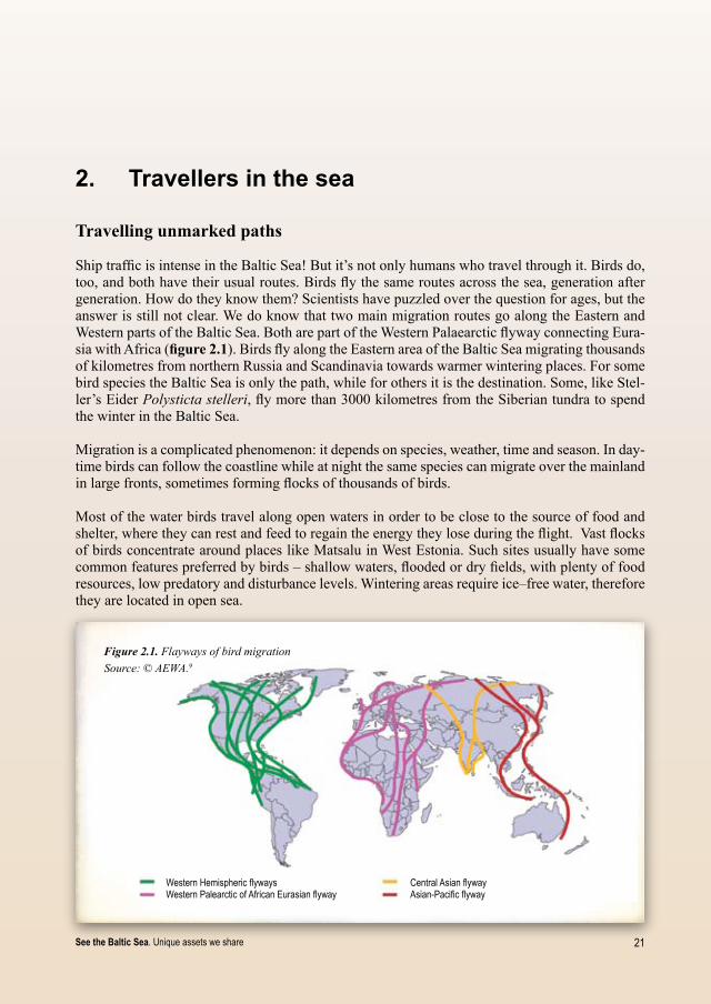
Figure 2.1. Flayways of bird migrationSource: © AEWA.9
Western Hemispheric flywaysWestern Palearctic of African Eurasian flyway
Central Asian flywayAsian-Pacific flyway
2. Travellers in the sea
Travellingunmarkedpaths
Ship traffic is intense in the Baltic Sea! But it’s not only humans who travel through it. Birds do, too, and both have their usual routes. Birds fly the same routes across the sea, generation after generation. How do they know them? Scientists have puzzled over the question for ages, but the answer is still not clear. We do know that two main migration routes go along the Eastern and Western parts of the Baltic Sea. Both are part of the Western Palaearctic flyway connecting Eura-sia with Africa (figure2.1). Birds fly along the Eastern area of the Baltic Sea migrating thousands of kilometres from northern Russia and Scandinavia towards warmer wintering places. For some bird species the Baltic Sea is only the path, while for others it is the destination. Some, like Stel-ler’s Eider Polysticta stelleri, fly more than 3000 kilometres from the Siberian tundra to spend the winter in the Baltic Sea.
Migration is a complicated phenomenon: it depends on species, weather, time and season. In day-time birds can follow the coastline while at night the same species can migrate over the mainland in large fronts, sometimes forming flocks of thousands of birds.
Most of the water birds travel along open waters in order to be close to the source of food and shelter, where they can rest and feed to regain the energy they lose during the flight. Vast flocks of birds concentrate around places like Matsalu in West Estonia. Such sites usually have some common features preferred by birds – shallow waters, flooded or dry fields, with plenty of food resources, low predatory and disturbance levels. Wintering areas require ice–free water, therefore they are located in open sea.
22 See the Baltic Sea. Unique assets we share
Great Crested Grebe in summer plumage
Black–throated Diver
Diversityoffoodpreferences
Water birds migrating through or wintering in the Eastern Baltic Sea have some common traits. One way to group them is according to their most beloved food.
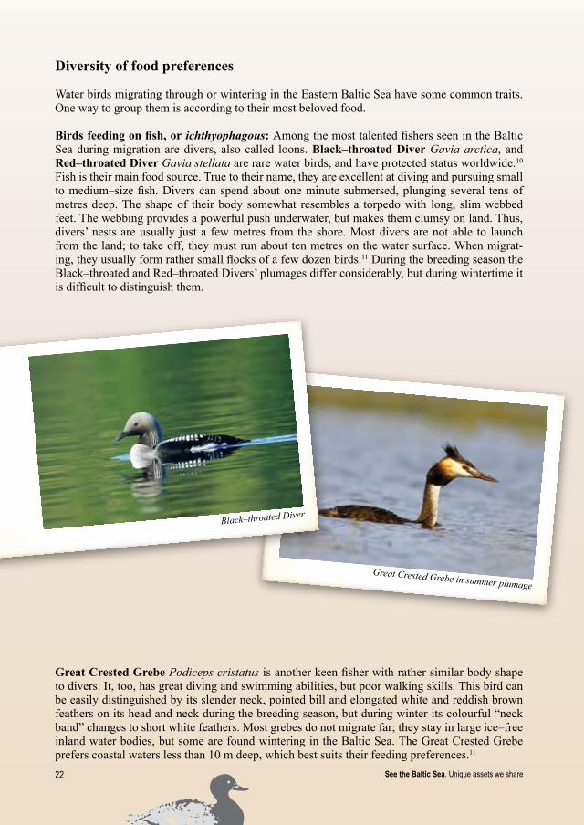
Birds feeding on fish, or ichthyophagous:Among the most talented fishers seen in the Baltic Sea during migration are divers, also called loons. Black–throatedDiver Gavia arctica, and Red–throatedDiver Gavia stellata are rare water birds, and have protected status worldwide.10 Fish is their main food source. True to their name, they are excellent at diving and pursuing small to medium–size fish. Divers can spend about one minute submersed, plunging several tens of metres deep. The shape of their body somewhat resembles a torpedo with long, slim webbed feet. The webbing provides a powerful push underwater, but makes them clumsy on land. Thus, divers’ nests are usually just a few metres from the shore. Most divers are not able to launch from the land; to take off, they must run about ten metres on the water surface. When migrat-ing, they usually form rather small flocks of a few dozen birds.11 During the breeding season the Black–throated and Red–throated Divers’ plumages differ considerably, but during wintertime it is difficult to distinguish them.
GreatCrestedGrebe Podiceps cristatus is another keen fisher with rather similar body shape to divers. It, too, has great diving and swimming abilities, but poor walking skills. This bird can be easily distinguished by its slender neck, pointed bill and elongated white and reddish brown feathers on its head and neck during the breeding season, but during winter its colourful “neck band” changes to short white feathers. Most grebes do not migrate far; they stay in large ice–free inland water bodies, but some are found wintering in the Baltic Sea. The Great Crested Grebe prefers coastal waters less than 10 m deep, which best suits their feeding preferences.11

2�See the Baltic Sea. Unique assets we share
Goosander female and male
Razorbill
GoosanderMergus merganser has notches along the sides of its long red bill, which help to catch and hold slippery fish. When it’s looking for fish, Goosander swims with only its head submerged, then dives as soon as it spots a fish. Water is its feeding place and shelter, therefore flushed goosander would rather dive than fly. Goosander is quite a big water bird which nests in the cavities of old trees growing close to water. This limits their breeding, because such favored places for nesting are often hard to find. At the end of autumn, some move to big water bodies which do not freeze over and some, to the coastal waters.11
Perhaps the most interesting water bird wintering in the eastern Baltic Sea is the RazorbillAlca torda. Why? Well, although there is no chance of seeing a penguin in the Baltic Sea, there are always people who claim they did. What they have probably seen is a Razorbill. This bird looks somewhat like a penguin with its portly body and white and black “suit” but, unlike penguins, Razorbills can fly above water as well as being able to swim under it. They are truly marine birds, spending almost all their time in the water, where they fish, preen and even sleep, coming onshore only to breed. When in danger, however, they are more likely to dive than to fly, making Razorbill extremely vulnerable to oil spills: by diving, they unintentionally collect more oil than they would if they flew off. Razorbills breed in colonies on the ledges of cliffs, where predators have little chance to snatch their eggs or young12. During the breeding season, you can find only a few pairs breeding in Estonia in the Baltic States, while during the winter season they can be observed here in large numbers.

2� See the Baltic Sea. Unique assets we share
Birds feeding on sea bottom creatures, or benthivorous: Some bird species prefer such sea food delicacies as molluscs, crustaceans, insects’ larvae, worms and other marine invertebrates, though they sometimes catch a fish or take a nibble of plant materials. This group includes ducks like Steller’s Eider, Velvet Scoter, Long–tailed Duck and Goldeneye, which dive to the sea bottom to feed.
Steller’s Eider Polysticta stelleri is one of the rarest and most endangered sea ducks in the world, perhaps already wavering on the brink of extinction. A possible reason might be related to unknown problems in their remote breeding sites as well as by threats here in their wintering locations. The Baltic Sea is the most important wintering site for the Steller’s Eider in Europe. Several thousand individuals of this smallest eider species gather in the coastal waters of Estonia and Lithuania and can be observed from the shore. Since they feed on benthic organisms, they prefer relatively shallow waters where it is easier to reach the bottom when diving. While at win-tering sites they form compact flocks.11 Males can be easily distinguished from other duck species by their white head with several greenish spots, black neck and chestnut chest. Both males and females have bluish bills.
Velvet Scoter female
Steller’s Eider female
Velvet Scoter male
Steller’s Eider male

2�See the Baltic Sea. Unique assets we share
Of the 18 duck species wintering in the Eastern Baltic Sea, the VelvetScoterMelanitta fusca is one of the darkest. Male birds have a characteristic white tear–drop just under the eye and a white wing patch. After breeding in tundra they come to the Baltic Sea for wintering in large flocks of several thousand. Pomerania Bay, the west coast of the Gulf of Riga and Irbe Strait are the most important overwintering sites for the Velvet Scoter in Europe. This broad–billed duck collects molluscs and crustaceans from the sea bottom as deep as 30 metres, sometimes snatching a fish as well.11
Of all the ducks wintering in the Eastern Baltic Sea, Long–tailedDuck Clangula hyemalis has one of the most impressive tails with long, slender central feathers. Parts of its plumage, which differs depending on sex, age and season, change up to three times a year. Most other ducks moult only twice. Long–tailed Duck is a splendid diver, often plunging 10 metres deep to the sea bot-tom while looking for molluscs and crustaceans.11 In fact, during the daytime it spends more time underwater than on the surface. At the wintering sites the Long–tailed Ducks form large flocks of several hundreds or even thousands of individuals. The huge numbers mean that some are div-ing while others await their turn, resting on the surface. Therefore it is easy to observe them. In springtime, they can be easily traced by their quite nice voice. When they group together, it seems as if the sea itself is singing.
Surface feeders: Not all birds prefer food from the sea. Some of them are keen to use their wings for chasing their prey. For example, during the breeding season, LittleGullLarus minutus mainly feeds on insects, e.g. dragonflies, mayflies, stoneflies, midges and beetles, but also gathers small fish and water invertebrates. Only a few thousand pairs breed in the Baltic States, but they often fly above the Baltic Sea during the warm season rather than in wintertime.10 At the end of summer, not waiting for the colder autumn days to come, most Little Gulls leave for the South, although sometimes a few stay for the winter. During migration they gather small crustaceans and fish from the water surface. Little Gull is the smallest gull in the world and is rare throughout Europe.10 Little is known about this gull and the reasons for its rarity are not yet understood.
Little Gull
Long–tailed Duck

26 See the Baltic Sea. Unique assets we share
Plant feeders, or herbivores: Some bird species visiting the Baltic Sea during migration prefer vegetarian food. TundraSwan Cygnus columbianus has a few resting sites in the Baltic States. Sometimes several individuals stay for the whole winter season in the shallow brackish lagoons, sheltered coastal bays and estuaries, where they forage and sleep on open waters. Tundra Swan’s menu includes seeds, fruits, leaves, roots and stems of aquatic plants; they select their wintering or resting sites based on the availability of plants.11
Themainthreatstobirdsinthesea
Numerous flocks of birds migrate every year, but not all birds safely reach the wintering places and return to their breeding areas. During breeding or moulting periods birds are affected negatively by such threats as habitatdegradation and disturbance caused by human activi-ties. The survival of migratory birds is also highly dependent on conditions at the wintering or resting sites. Migration and wintering are critical periods in birds’ lives. Migration means hard work. They fly hundreds or even thousands of kilometres in a short time span. The flight expends energy reserves they gained during the intensive feeding period before migration. It is crucial for birds to take time to rest and regain lost energy; their survival depends on it.
Wintering has similar dangers. To maintain normal body temperature during cold winter, birds need to feed regularly. If unable to do so, they deplete their reserves, loosing body weight each time they spend a day without enough food. If such conditions last, birds can become too ex-hausted to persist and survive. In water bodies without human activity this rarely happens, but in the intensively used Baltic Sea it can occur much too often. Navigation, fishing and hunting keep birds busy to avoid dangers, they are unable to take time to feed. Every time birds are driven away from food sources they are forced to use their inner reserves which, in winter, are already scarce.
It is not always possible to measure the level of disturbance. The effect of commercial fishing at the birds’ feeding site is quite obvious, but that is not the case with coastalor offshorewindfarms. The generation of electricity from wind energy is a more environmentally friendly ap-proach than using fossil fuel sources. However, possible negative effect on bird migration has to be taken into account. As stated above, bird migration flyways are like broad corridors. Depend-ing on weather conditions, time and season, the same bird species might choose different paths within the same flyway. Therefore it is impossible to produce a map showing precise pathways of migrating birds and plan the location of wind turbines accordingly. There is increasing interest in erecting wind turbines in relatively shallow waters, where the wind is much stronger than on the mainland, and construction is still affordable. Unfortunately, some bird species migrating above the sea prefer exactly the same waters. If migrating birds fly into the wind farm area, flocks can be dispersed and some are likely to die from collision with turbines. The stress affects them as well. Might they loose their migration track? Since birds hatch with a strong migration instinct, this seems hard to believe, but confusion takes its toll, threatening stores of energy so needed for the long flight. Different bird species react differently to the wind turbines. Divers try to avoid them while some ducks are able to adjust.
Besides disturbance, there is also a wide range of direct threats for migrating and wintering water birds in the Baltic Sea: oil spills, pollution with hazardous substances, such as heavy metals and pesticides, as well as hunting, by–catch in fishing nets, and declining food sources.

2�See the Baltic Sea. Unique assets we share
With such intense navigation in the Baltic Sea, oilspills are occurring rather often. It is not only a case of large tankers’ accidents. Every minor oil spill – pumping fuels, making repairs or even simple, normal ship use – is a source for pollution of the sea with oil products. When birds swim in polluted water, oil soaks and binds their feathers. They loose insulation and become unable to maintain the needed body temperature which, in turn, prevents them from diving and leads to death from cold or heat, dehydration, starvation and weakness.
All birds preen their feathers every day. If their plumage is covered with oil, birds try to remove it and unintentionally ingest it in the process. The oil damages internal organs; the bird becomes intoxicated. Although remarkable efforts are made to clean them, it does not always produce the desired results. The chances of survival depend on many factors: the amount of oil on the bird, how long it has been oily, the manner of cleaning and care during recovery time, as well as spe-cies, age, habitat, food source and other factors. Unfortunately, a considerable number of cleaned birds are not able to survive. Depending on the amount of oil ingested by the bird, those that do survive the cleaning process may suffer from behavioural changes: for example, they may no longer be able to reproduce. Every drop of oil going into the waters takes lives; if not immedi-ately, then later.
Fishingnets pose another serious threat for water birds wintering in the Eastern part of the Baltic Sea. When diving for food, birds become entangled in the nets and consequently die. Some birds, like Long–tailed Duck, are rather abundant so the problem of drowning in fishing nets does not necessarily threaten the entire species. However, some others, like Steller’s Eider and the divers are rare worldwide. Since the populations of such species are small and unfortunately declining, each bird killed in fishing gear is a small tragedy for our biodiversity. Furthermore, Steller’s Ei-ders usually stay in compact and dense flocks and dive simultaneously. So, if a fishing net is in their way, the entire group can drown!
Oily Long–tailed Duck female

2� See the Baltic Sea. Unique assets we share
Water birds have been or are still being hunted for food, sport or even plumage for the millinery trade. Great Crested Grebe and Common Tern Sterna hirundo suffered severe declines in the 19th century for the decoration of hats. Fortunately, millinery with feathers now appears to be out of fashion, but poaching is still a threat. Depending on its level, the effect of these threats might be minor or major.
As if these menaces are not enough, birds and humans compete for the same food sources. Intensive commercial fishery, exploitation of marine benthic organisms and shellfish are also causing decline of bird populations. Some species like Razorbills, Guillemots and Puffins die from starvation during winter because they are unable to catch enough fish to survive12. This trend has been recognized in the North Sea, but may be the case for the Baltic Sea as well. It is easier to maintain sustainable populations than to try to restore them to the previous population from a few remaining members of a species – be that birds, fish or other wildlife.
For every bird species, disturbances and man–created threats are dangerous. When one bird out of one million of a species dies, there is a relatively small loss. But for the rare and endangered species one bird may be of crucial importance. When the global population of a species is only 100 000 individuals, every bird is important and every loss is great. But surely every bird that perishes is a loss.
Steller’s Eider in fishing net

29See the Baltic Sea. Unique assets we share
3. Underwater meadows – variety of the Baltic Marine habitats
Few people probably know about beautiful underwater meadows hiding below the water surface of the Baltic Sea, since due to the cold water temperature and rather poor water transparency, it is not very popular for diving compared to the warm Southern seas. However, here too can the variety of habitats with or without vegetation and with different communities of marine organ-isms be found. This variety is determined by various environmental conditions – the depth and light conditions, salinity, influence of the waves and character of the sea bed – its geology and covering surface material.
To describe the spatial variety of the environmental conditions and living organisms such terms as habitats or biotopes usually are applied. In different times and different contexts these terms have been used with slightly different meaning, but sometimes as synonyms. Habitat, simply put, could be described as a place or particular environmental conditions in which a plant or animal lives. Biotopesare defined as the spatial components of an ecosystem characterised by specific ecological, unique and more or less constant environmental conditions.13 According to more re-cent interpretation biotopes are described by their physical characteristics as well as dominant biological features, thus recognising that living organisms not only respond to the prevailing environmental factors, but can also modify the environment. So in principal the term “biotope” encompasses the habitat (specific living conditions) and related plant and animal communities (i.e. biotope = habitat + community).14
Habitats can be distinguished by their location within the water column as well as by the distance from the coastline (figure 3.1) The transition area between land and sea is called the littoral zone, including the seabed, the shore and part of the coast that is influenced by waves, flooding and sea spray.1 The littoral zone is divided into several subzones: 1) the geolittoral, a coastal strip, only occasionally covered by water; 2) the hydrolittoral – an area which is mostly covered by water (lying between the mean and lowest water level); 3) the sub–littoral which extends up to the edge of the continental shelf or depth of more than 200 meters. Since the depth of the Baltic Sea hardly reaches 200 m, most of its area can be defined as sub–littoral. Depending on the depth two zones are distinguished: the photic (from Greek – “well lit”) – the upper layer where light is penetrat-ing in, and the aphotic zone, which daylight no longer reaches. The habitats on the sea bottom are called benthic habitats, while those above the sea bottom up to the water surface are pelagic habitats. Both pelagic and benthic habitats can be either in the aphotic or photic zone.15

�0 See the Baltic Sea. Unique assets we share
Figure 3. 1. Zonation of marine and coastal habitatsSource: Federal Agency of Nature Conservation, Germany, D. Boedeker, 1998.15
GEOLITTORAL
Marine habitats Terrestrial habitats
SUBLITTORAL HYDROLITTORAL
Pelagic habitats of thephotic zone
Highest water level
Mean water level
Lowest water level
Benthic habitats of the photic zone
Benthic habitats of the aphotic zone
Pelagic habitats of the aphotic zone
Seabedformingthedifferenthabitats
The character of the seabed is the next very important factor defining habitat type. It varies a lot within the Baltic Sea Proper as well as in its Eastern part along the coasts of the Baltic States, but for the purpose of habitat classification we can distinguish hard bottoms and soft bottoms.
Hard bottomsinclude crystalline bedrock, hard and soft sedimentary rocks, reefs, stony bottoms, gravel bottoms, hard clay bottoms, shell–gravel bottoms and mussel beds. Soft bottoms are cov-ered by sand, mud, peat or mixed sediments.1
The crystalline bedrock mostly formed by granite or gneiss is exposed in the areas around the Archipelago Sea, the northern part of the Gulf of Finland and on the coasts of the Bothnian Sea and Bay; on the northern coast of Estonia it is covered by a 150–200 metre thick layer of sedi-mentary deposits. The thickness of sedimentary layer increases towards the South – in the Gulf of Riga this layer is 1 km thick, on the Lithuanian coast – 2 km, and up to 8 km in the southern part of the Baltic Sea.1
Sedimentary deposits consist of various sorted and unsorted materials including boulders, peb-bles, gravel, sand, limestone and clay, created by the erosion, water pressure and various chemi-cal processes over millions of years, while their present distribution and formations are mostly evidence from the Ice Age.

�1See the Baltic Sea. Unique assets we share
Moraine ridges in Lithuania
Hard sedimentary rocks like sandstone and limestone have been formed in pre–Ice Age. Sand-stone rocks are found on the Eastern Baltic Sea coast and under water in the Gulf of Riga, near Tuja –Vitrupe, while limestone cliffs are characteristic of the Estonian coastline. There are also soft sedimentary rocks made from chalk, boulder–clay (moraine) or marl. Moraine cliffs can be found at the Lithuanian and the western Latvian coast.
Moraine is an unsorted mixture of boulders, stones, pebbles, gravel, sand and clay, which has been left behind by the melting glacier. At some point this material was pushed alongside or un-derneath ice forming large systems of ridges (or so–called end moraines). Recently, fascinating underwater canyons formed by up to 5–metre deep parallel moraine ridges were discovered near the coast of Palanga in Lithuania. This is the largest group of moraine ridges discovered so far and it extends over 5 km2. Marine researchers presume that these ridges are the remains of the old Baltic Ice Lake coastline dating back about 20 thousand years.
An extensive zone of reefs including the moraine ridges as well as patches of stones, gravel and sandy bottoms starts in Lithuanian waters a bit north of Klaipeda and extends to Pērkone in Latvia. Reefs and stony bottoms can also be found elsewhere in the eastern part of the Baltic Sea, e.g. near Hiiumaa and Saaremaa islands, and in the Gulf of Riga, etc. Sandy bottoms are typical for Lithuanian coastal waters near Curonian Spit as well in some parts of the Latvian sea bed. Mud–covered bottoms are more often found in Estonian waters.
�2 See the Baltic Sea. Unique assets we share
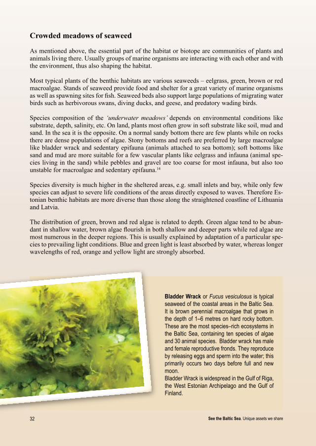
Bladder Wrack or Fucus vesiculosus is typical seaweed of the coastal areas in the Baltic Sea. It is brown perennial macroalgae that grows in the depth of 1–6 metres on hard rocky bottom. These are the most species–rich ecosystems in the Baltic Sea, containing ten species of algae and 30 animal species. Bladder wrack has male and female reproductive fronds. They reproduce by releasing eggs and sperm into the water; this primarily occurs two days before full and new moon. Bladder Wrack is widespread in the Gulf of Riga, the West Estonian Archipelago and the Gulf of Finland.
Crowdedmeadowsofseaweed
As mentioned above, the essential part of the habitat or biotope are communities of plants and animals living there. Usually groups of marine organisms are interacting with each other and with the environment, thus also shaping the habitat.
Most typical plants of the benthic habitats are various seaweeds – eelgrass, green, brown or red macroalgae. Stands of seaweed provide food and shelter for a great variety of marine organisms as well as spawning sites for fish. Seaweed beds also support large populations of migrating water birds such as herbivorous swans, diving ducks, and geese, and predatory wading birds.
Species composition of the ‘underwater meadows’ depends on environmental conditions like substrate, depth, salinity, etc. On land, plants most often grow in soft substrate like soil, mud and sand. In the sea it is the opposite. On a normal sandy bottom there are few plants while on rocks there are dense populations of algae.Stony bottoms and reefs are preferred by large macroalgae like bladder wrack and sedentary epifauna (animals attached to sea bottom); soft bottoms like sand and mud are more suitable for a few vascular plants like eelgrass and infauna (animal spe-cies living in the sand) while pebbles and gravel are too coarse for most infauna, but also too unstable for macroalgae and sedentary epifauna.14
Species diversity is much higher in the sheltered areas, e.g. small inlets and bay, while only few species can adjust to severe life conditions of the areas directly exposed to waves. Therefore Es-tonian benthic habitats are more diverse than those along the straightened coastline of Lithuania and Latvia.
The distribution of green, brown and red algae is related to depth. Green algae tend to be abun-dant in shallow water, brown algae flourish in both shallow and deeper parts while red algae are most numerous in the deeper regions. This is usually explained by adaptation of a particular spe-cies to prevailing light conditions. Blue and green light is least absorbed by water, whereas longer wavelengths of red, orange and yellow light are strongly absorbed.

��See the Baltic Sea. Unique assets we share
Red Seaweed or Furcellaria is a reddish–brown alga which can grow up to about 30 cm in length. When growing, every branch divides into two. In Europe, it is found from northern Norway to the Bay of Biscay, including the Baltic Sea, and also in the Mediterranean Sea. It abounds in the Gulf of Riga in the Eastern Baltic, the West Estonian Archipelago and the Gulf of Finland. It is the only large macroalga present at the Lithuanian and Latvian coast of the Baltic Proper. In most of the Baltic Sea, Furcellaria forms a continuous belt just below the bladder wrack belt. In the open coastal waters of Lithuania and Latvia, where the bladder wrack cannot grow, Furcellaria forms dense meadows in depth of 4–10 m, while solitary algae can be found even in 15–16 m deep. Many fish species, among them the Baltic herring, use Furcellaria as spawning grounds.
Eelgrass or Zostera marina is vascular plant with dark green, long narrow, ribbon–shaped leaves 20–50 cm in length with rounded tips. It is the most common species of seaweed growing in the Northern Hemisphere and is abundant in the Estonian coastal waters and the Gulf of Riga. In open sandy coastal waters of Lithuania and Latvia eel-grass cannot grow due to strong wave impact. Eelgrass meadows are home for 22 animal species.

�� See the Baltic Sea. Unique assets we share
Reefs
SurprisinghabitattypesintheEasternBalticSea
Reefs are probably the most attractive and ecologically significant habitat types in the Eastern part of the Baltic Sea, real oases sustaining high biodiversity of fishes, birds, invertebrates and plants. Reefs may be of biological (e.g. coral reefs) or geological origin; those in the Baltic Sea formed on the stony bottoms and rocks rising from the surrounding sandy seabed. Most reefs are found in the depth range of 2–20 m. Depending on specific environmental conditions in each region they develop into unique formations providing home for specific types of vegetation and animals. The most typical species here are red, brown and green macroalgae, animal species at-tached to the bottom, e.g. bivalves, ascidias, bryozoa, as well as molluscs (Modiolus modiolus, Mytilus sp., Dreissena polymorpha), crustaceans and benthic fish. Reefs are also used as spawn-ing grounds by most of the commercially important fish species. They provide feeding areas for diving birds who feed on molluscs and crustaceans. Reefs attract also fish which are followed by seals. Thus reefs play a significant role in the food chain. Taken together, the reefs in the Eastern Baltic Sea occupy the area of over 8000 km2 which is almost half the size of the Gulf of Riga. If the reefs are destroyed, the whole ecosystem may collapse.
Submerged sandbanks, as the name implies, are related to sandy bottoms. This habitat type is typical of shallow coastal waters or raised parts of the sea bottom (up to 20 m depth) in the deeper waters. At the coastal areas exposed to waves no vegetation can develop on the sandy bottoms – sand is washed there continuously, as in a washing machine. Animals appearing there – mussels, worms, crayfish and the like – have to dig themselves down into the sediment. Sandbanks in more sheltered areas overgrow with seaweed like eelgrass and form rich species communities. They are also important as fish spawning grounds and as feeding and wintering areas for water birds.

��See the Baltic Sea. Unique assets we share
Estuariesoflargerivers also form specific habitat types.Estuaries are always transition zones, where freshwater from rivers meets the brackish water of the sea. They can be of different shapes such as bay–like river mouths, deltas or parts of an archipelago. Estuaries are present throughout the whole Baltic Sea area. In the Eastern Baltic Sea the most typical example of a river mouth area is Neva estuary in St. Petersburg. An estuary is influenced both by marine as well as river ecosystems; it may contain a large variety of biological niches within a small area. Its specific nature is also characterised by two main physical processes. First, fresh water is lighter than salt water and can cause the formation of two layers within the water column. A specific two–way cir-culation tends to stimulate primary production and further provides opportunity for plankton and fish. The second special feature is that rivers commonly carry a load of suspended sediment to the estuary and develop a zone known as the turbidity maximum. Estuaries are important breeding, resting, and feeding sites for water birds.
Attemptstoclassifymarinehabitats
The habitat types described above are only few examples of the variety represented by the Baltic Sea underwatermeadows. There have been several attempts to classify the marine habitat for the purpose of scientific research or nature protection.
The European Commission in 1992 has adopted a list of the most vulnerable habitat types to be protected within EU (Annex I of the Habitats Directive). This list also includes two marine habitat types represented in the Baltic Sea – reefs and sandbanks, as well as coastal habitats like lagoons, estuaries, large shallow inlets and bays as well as mudflats and sand flats not covered by sea water all the time. However, this list focuses only on few habitat types of special protection interest and does not provide an overall classification system.
In the Baltic region one of the first initiatives to develop an internationally agreed classification system was undertaken by HELCOM. As a result, the Red List of Marine and Coastal Biotopes and Biotope Complexes of the Baltic Sea was published in 199815. However, this list, too, has turned out not to include sufficient detail to describe the complexity of the Baltic Sea.
On the European scale an overall classification system is offered by the European Environmental Agency (EEA) as a part of the European Union Nature Information System (EUINIS). To date, it has been too broad and not sufficient to describe the local conditions of the Baltic region. However, the system is constantly being updated, thus offering a possibility to integrate regional specifics.
To provide a more comprehensive description of the Eastern part of the Baltic Sea and to have a common system for joint research activities, the Baltic hydrobiologists have developed their own classification system in the framework of the EU LIFE–Nature programme’s financed project on “Marine Protected Areas in the Eastern Baltic Sea”16. It groups the habitats first, according to their exposure to the waves (sheltered, moderately exposed or exposed), then by character of the sea bottom (soft or hard), and finally by the presence of typical species of vegetation or other living organisms such as bivalves. For example, one of most typical reef habitats is called “sheltered hard bottoms with Fucus vesiculosus”.
This will probably not be the last attempt to classify the Baltic marine habitats. As we gain more knowledge about the marine ecosystem, our view of its different components may become more specific or more complex.
�6 See the Baltic Sea. Unique assets we share
Bladder wrack overgrowing with filamentous algae
Themainthreatstounderwaterhabitats
Mechanicaldestructionis the major threat to the benthic habitats. It can be caused by dredging in order to create new shipping roots as well as by dumping of dredged material. Furthermore any construction works in the sea, such as the building of wind parks as well as excavation of mineral resources can directly destroy the habitat. In addition, hydrotechnical constructions at the coast (e.g. breakwaters, piers, marinas) can cause changes in sediment flow which in its turn may lead to accumulation of sand and burial of reefs. Therefore modelling of sediment flow would be necessary before creating new construction. Some fishery techniques, bottom trawling, for example, can have very harmful effects on habitat.
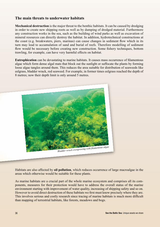
Eutrophicationcan be devastating to marine habitats. It causes mass occurrence of filamentous algae which form dense algal mats that block out the sunlight or suffocate the plants by forming loose algae tangles around them. This reduces the area suitable for distribution of seaweeds like eelgrass, bladder wrack, red seaweed. For example, in former times eelgrass reached the depth of 8 metres; now their depth limit is only around 5 metres.
Habitats are also affected by oilpollution, which reduces occurrence of large macroalgae in the areas which otherwise would be suitable for these plants.
As marine habitats are a crucial part of the whole marine ecosystem and comprises all its com-ponents, measures for their protection would have to address the overall status of the marine environment starting with improvement of water quality, increasing of shipping safety and so on. However to avoid direct destruction of these habitats we first must know precisely where they are. This involves serious and costly research since tracing of marine habitats is much more difficult than mapping of terrestrial habitats, like forests, meadows and bogs.

��See the Baltic Sea. Unique assets we share
Ringed seals at resting area
4. Fragile life of mammals
The Baltic Sea is home for four species of marine mammals: the harbour porpoise, the grey seal, the ringed seal and the harbour seal. The latter is occurring only in the southern part of the Baltic Sea. Here we focus on the two other seal species and the harbour porpoise that can be met also in the waters of the Baltic States.
Ringedseal–thesmallestsealintheworld
TheBalticringedseal Phoca hispida botnica is the smallest seal in the world – its body length is 130–150 cm and weight 50–60 kg. The weight varies depending on season; in autumn it can be up to 100 kg. Characteristic for the ringed seal is the pattern of its fur: light ring–shaped blots on the back and dark ring–shaped blots on the belly. The ringed seals reach sexual maturity at the age of 3–6 years and can live up to 40 years of age, usually 20–25 years. Baltic ringed seals feed mainly on pelagic fish such as herring and smelt, but also bottom–dwelling species: sculpin and viviparous blenny. Crustaceans also form part of their diet, especially isopods during the winter.

�� See the Baltic Sea. Unique assets we share
Ringed seal pup
Distributionandlifestyle: The ringed seals inhabit mainly northern parts of the Baltic Sea with three subpopulations in the Bothnian Bay, the Gulf of Finland and West–Estonian Archipelago. In the ice–free period they usually feed in deep waters, and between foraging trips associate in small social groups (up to ca 10 animals) gathering on certain reefs and underwater rocks.
During the winter the seals are found alone or in pairs, spread out in the ice fields, and are often aggressive to other individuals. They look for certain ice types (pack ice and ice ridges) where they can build nests and systems of breathing holes. Each female ringed seal has several breathing holes in the ice and moves between them in case of disturbance. They can keep their breathing holes open even when ice is several meters thick. Ice is very important for this arctic species as it breeds only on ice, unlike the grey seal whose pups can be born on ice or land.
Thecutestpupsintheworld:the pups are born in lairs on the pack ice in late February – early March. Availability of the ice is absolutely essential for survival of the ringed seal pups; if born into water they will die. Usually one pup is born, weighing ca 4,5 kg. The fat content of the seal mother’s milk is ca 38%, so after the nursing period lasting 39 days the weight of the seal pup is already ca 20 kg. The newborn ringed seals are very active. While grey seal pups are mainly immobile, the ringed seal pups spend 50% of the time in water and can dive for up to 12 minutes.
Anendangeredspecies:Historically, the ringed seal has been a very numerous species in the Baltic Sea, inhabiting all its northern and central areas with ice–cover in winter. It is estimated that there were up to 200,000 Baltic ringed seals at the start of the 20th century. Intensive hunt-ing and pollution, however, have reduced their numbers considerably. Hunting of this species is now banned throughout the Baltic Sea. Currently approximately 6500–8000 ringed seals are living here, but their survival depends a lot on climate conditions and the presence of ice cover in early spring, so essential for the breeding success of this seal species. If the ice cover melts before the seal pups are ready for starting their own life, they have no chance to survive.17 18 19

�9See the Baltic Sea. Unique assets we share
Grey seals
Greyseal–thelargestsealintheBalticSea
Thegreyseal Halichoerus grypus is the largest of the three Baltic seal species: adult males may reach over three metres in length and 300 kg in weight.18. There is a great variety in coat col-oration and shading of grey seals. Males tend to have a dark brown–grey coat, with a few light patches, while females are generally light grey–tan coloured, lighter on the front, with dark spots and patches. Adult males, and some older adult females, have a recognisable long “Roman” nose with wide nostrils, giving the species its name “horsehead” in Canada and its Latin name that translates as “hooked–nose pig of the sea”.
The grey seals reach sexual maturity from 4–6 years. Females can live up to 35 years of age, males up to 25 years. They feed mainly on Baltic herring, sprat, whitefish, cyprinids, viviparous blenny and flounder but also other fish species. For feeding they dive 30–70 m deep in the sea and can stay there for more than 20 minutes.17
Mobilelifestyle:As active travellers, the grey seals inhabit the whole Baltic Sea. Their haul–out areas are located mainly in the central and northern part of the sea. Unlike ringed seals, the grey seals are gregarious and gather together for breeding, moulting and hauling out at exposed ar-eas. It is mainly an offshore species, whose main haul–out areas – low islets without vegetation or reefs – are located far from shores and human settlements. They can be seen also in shallow coastal bays, river mouths and sometimes in harbours, but mainly in spring and autumn when they are following fish moving to the spawning grounds. The main breeding season of grey seals in the Baltic Sea is from February to March. They mostly give birth on drift ice or, in warm winters, also on small islands. There is usually one pup weigh-ing 10–12 kg. The pup is born with a creamy–white woolly lanugo coat, which it will moult after 2–4 weeks for a shorter adult–like coat. During the 18–day nursing period the pup gains 30–40 kg in weight. After weaning, the pups stay at the rookery until they have fully moulted, living off its blubber reserves. After that, they disperse in many different directions from the rookery and are known to wander widely – distances over 1,000 km are not uncommon.

�0 See the Baltic Sea. Unique assets we share
Mating takes place towards the end of the nursing period. Generally the males enter the rookeries at about the time the females start to pup and try to gain sole access to groups of females. The suc-cessful males are able to mate with 2–10 females. Neither lactating females nor dominant males feed during the breeding season – usually about 3 weeks for females and sometimes for up to 6 weeks for males. After mating, the seals disperse and wander widely in order to feed, usually in the open sea.
Grey seals in the Baltic Sea moult on land or ice from April–June.17 20
Recoveringpopulation: Historically the grey seal has been very numerous in the Baltic Sea – in the beginning of the 20th century the population was ca 80 000–100 000 animals – but as result of hunting and pollution the number of grey seals decreased significantly, reaching the lowest level – ca 4000 animals – in 1970s.
Thanks to the protection measures and also due to the improved environmental status of the Bal-tic Sea, the Baltic population of the grey seal is now recovering fast – in 2008 there were about 23,000 individuals. Therefore also their hunting, which was banned throughout the Baltic Sea in 1988, was recently re–opened in Finland and Sweden.21 The increasing number of grey seals worries fishermen, who now have to compete with seals for their catch. This is most obvious in Estonian waters, but Latvian fishermen also tend to say that soon there will be nothing to catch as seals are consuming all the fish.
Harbourporpoise–theonlyresidentwhaleintheBalticwaters
Theharbourporpoise Phocoena phocoena is the only whale species breeding in the Baltic Sea. The name derives from French pourpois, originally from Medieval Latin porcopiscus (porcus pig + piscus fish).
Harbour porpoise is one of the smallest toothed whales having a stocky body and a rounded snout with no prominent beak. The females usually grow bigger than the males with a mean body length of 160 cm and the weight of 60 kg, compared to the males’ 145 cm and 45–50 kg; they are believed to have a lifespan of approximately 20 years.
Harbour porpoise surfacing

�1See the Baltic Sea. Unique assets we share
Harbour porpoises inhabit shallow coastal waters as well as bays and estuaries; they may even enter rivers and canals. In the water the harbour porpoise looks dark grey. When surfacing it has a rolling movement and only the small triangular dorsal fin and a little of the body can be seen. One of the harbour porpoise’s nicknames, the puffing pig, is derived from the sound of its blowing when it comes to the surface for air. The noise made sounds like a human sneezing or puffing.
They usually do not aggregate in larger groups, but are most often seen as single animals or smaller groups of 2–6 animals. Unlike dolphins they are shy animals keeping away from boats and ships and only occasionally leaping out of the water. Sometimes they can be seen lying on the surface for a while between the dives.
The porpoise is not a very fast swimmer, but may reach a speed of up to 23 km/h. When it is hunt-ing, it dives for approximately four minutes (up to six minutes) and may reach a depth of more than 60 m. Porpoises navigate and locate their prey by sonar (echolocation). They feed on a wide variety of pelagic and demersal fish as well as on marine invertebrates. Main prey appears to be schooling fish species, such as herring, mackerel and sand eel.
Female harbour porpoises give birth to one calf every one–to–two years. The calf is born in spring (after 10–11 months gestation period) and nursed for 7–8 months.
At the beginning of the 20th century, harbour porpoises were common in the Baltic Sea. How-ever, due to by–catch, severe winters, hunting, habitat degradation and pollution, the population has decreased dramatically, and today Baltic harbour porpoises are classified as endangered. Cur-rently the total Baltic population is estimated at as few as 600 porpoises that appear quite regu-larly off the coast of Denmark and Germany but are rare in other regions.
All sightings of this animal should be reported to the nearest environmental administration.22 23 24 25
Fivereasonswhyitisnotsoeasytobeamarinemammal
Predators:In the Baltic Sea the grown–up seal is the top of the food chain that has no potential enemies except man. However, gulls, sea eagles and, in case of unfavourable ice conditions, ter-restrial predators like fox, wolf and dogs can be a danger for the pups. Hunting of marine mam-mals is not allowed in the Baltic Sea, except limited hunting of grey seals in Sweden and Finland. However, illegal killing still sometimes takes place.
Pollution: Being the top of the food chain is a good position because there is no danger of be-coming somebody’s food. On the other hand, all toxins contained in the marine environment ac-cumulate in the top predators. Marine mammals have suffered greatly because of organochlorines causing infertility of female seals and heavy metals damaging mainly the synthesis of enzymes (liver) and muscles.
A special form of chemical pollution is potential leakage from the dumping of chemical weapons drowned after World War II. This poses grave risks for marine mammals that often dive and feed in deeper parts of the sea in the vicinity of dumping sites of weapons.
Oil pollution is more dangerous for the seal pups because oil–covered pups can freeze and die, especially if the mothers transport them away from the pollution area, causing them to swim for long periods in the cold water. Oil damages the eyes and respiratory organs of the marine mam-mals, as well as other tissues via intake to the lungs. Contaminated food causes damages in the

�2 See the Baltic Sea. Unique assets we share
liver and kidneys, and oil compounds accumulate in the fat tissue, posing a danger in starvation periods such as breeding and moulting times.
Disturbance: In wintertime the ship traffic can be an especially dangerous disturbance factor for the ringed seals breeding on ice. The shipping lanes break the solid ice fields and destroy the structures built by the seals. The re–frozen shipping lanes are attractive for the ringed seals due to artificial ice piles that are suitable breeding habitat, therefore re–opening the frozen shipping lanes is more dangerous for the seals than creating new ones. Furthermore, the hydro–acoustic noise created by the ships moving through the ice is a distur-bance to seals because they use sounds for orientation, feeding and communication under water. Skidoos and cars moving on ice, planes and helicopters flying over and even people skiing or walking can disturb seals.
During the ice–free period the human disturbance at haul–out sites and migration routes is dan-gerous. Ringed seals are shyer than grey seals, but the escape distance depends on intensity of irritants such as noise, light or smell. For example, in the case of a boat approaching a haul–out site the critical distance is ca 500 m, but for more noisy vehicles it can be as much as 1,5–2 km. Disturbance is most dangerous during the breeding season when the seal mother can be scared away from the pup, or during moulting when seals need to spend more time out of the water. At that time, they have not yet recovered from energy resources lost during the winter and breeding period.
Climatechange:Increasing frequency of warm winters is especially influencing the ringed seal; the Gulf of Riga is the southern border of its distribution range in the whole World. The survival of this species in the Baltic Sea is highly dependent upon ice conditions during breeding season. Unfavourable breeding conditions magnify the influence of other threats on the Baltic Ringed Seal population. Reduction of global warming can be reached only by efforts taken on a global scale, but we must do our best to minimise the other threat factors. Unlike the seals, the harbour porpoises do not like severe winters and can live only in areas with-out ice cover.
Fishery:Fishing endangers the marine mammals in three ways: disturbance of seals in breeding and haul–out sites, competition for food resources and by–catch in fishing gears.
Intensive fishing can influence the food base of the seals. To gather sufficient energy resources they have to feed intensively before the winter and breeding season. The energy deficit due to decrease of the food resources influences first, the success of breeding and through that, the population dynamics. By–catch endangers mostly young seals. Due to their smaller size and lack of experience, they can more easily get entangled in fyke and gill nets than adult seals. A significant number of seals die each year from entanglement in fishing gear.
At the same time, the fishermen are angry at seals because they compete for the fish resources and can damage fishing gear. The solution for this problem is not killing all seals but using improved fishing gear that avoids by–catch and is resistant to seal attacks. Solutions satisfying both sides are possible!
By–catch in gill nets is also a serious danger for the diminished harbour porpoise population. 19 21 23

��See the Baltic Sea. Unique assets we share
Protectionofmarinemammals
Both above described seal species are listed in the Red List of International Union for Conserva-tion of Nature (IUCN) and protected by the European Community’s nature conservation legisla-tion as well as national laws of various EU member countries.
The harbour porpoise is a protected species worldwide. The genetically isolated Baltic population features as vulnerable on the Red List of the International Union for Conservation of Nature and is protected by the legislation of the European Community as a species requiring strict conserva-tion. The harbour porpoise is also protected by a special international agreement – the Agreement on the Conservation of the Small Cetaceans of the Baltic and North Seas (ASCOBANS).
The problem of protecting marine mammals from being accidentally by–caught has been reflect-ed in the recent regulations regarding EU fisheries policy. Within the next few years the Baltic Sea countries should cease to use driftnets in salmon fishery, introduce independent observers on fishing boats and use acoustic deterrents in some fisheries.17 20 23

��

��See the Baltic Sea. Unique assets we share
Shorthorn sculpin
5. Baltic herd of fishes
Large stocks, but low diversity
One of the main treasures of the Baltic Sea is its fish population. A typical feature of the shallow North European seas is very high fish productivity 26. That can be said also about the Baltic Sea which hosts the large stocks of sprat and herring. But at the same time species diversity (number of fish species living here) is rather low. Due to the young age of the sea and specific salinity pat-tern, only a small number of fish species has successfully colonized this water body. Therefore you can find there only a few typical Atlantic species (e.g. cod, herring and sprat); for others, the water of the Baltic Sea is too brackish. But on other hand, the low salinity allows some freshwater species to occupy the coastal waters. Scientists have discovered that both marine and freshwater species living here have adapted to the condition of the Baltic Sea by changing many vital charac-teristics of their biology. So, if some catastrophic changes would happen in the Baltic Sea, we can not expect that ‘new cod’ will swim in through the Kattegat. Cod of the North Sea, for example, could not reproduce in the brackish waters, or to be more exact, it would take thousands of years for them to adapt. Baltic populations of the commercially used fish species (those which are popular items on our menu – like sprat, herring, cod, flatfish and salmon) are thoroughly studied and monitored. Ich-thyologists can provide detailed information on their distribution, migration roots, stock values, etc. But little is known about the fish species which do not have commercial value, among them the most rare or threatened species – shorthorn sculpin Myoxocephalus scorpius, four–horned sculpin Triglopsis quadricornis and bullhead Cottus gobio.

�6 See the Baltic Sea. Unique assets we share
Baltic herring Clupea harengus membrasThe Baltic herring is the dominant fish species in the Baltic Sea. They occur in large shoals throughout the Baltic except very fresh areas like the Curonian Lagoon. The herring spawn in May and June. They usually lay their eggs on macro algae like Fucus and Fucellaria. The most important spawning sites are in Pärnu Bay, near Salacgriva, near Nida and near Klai-peda. The herring stock in the Baltic Proper had been steadily declining for a couple of decades but now is on the rise again. Conservation of spawning sites is fundamental for the herring stocks to thrive.2�
Sprat Sprattus sprattus balticusSprat is an abundant species throughout the Baltic Sea except in brackish bay areas. It forms large shoals in the areas where waters of different salinity are mixing. It migration distances are limited. During winter it stays in depth of 70 – 100 m, going to warmer upper layers in spring and summer, and retreating to depth in autumn. The spawning period of sprat is from March to August. It mostly feeds on pe-lagic crustaceans.2�
Fishcommunities
Despite the fact that there are no clear ‘borders’ in the sea, the fish fauna of the Baltic Sea may still be divided into three general communities: a pelagic community – occupying the main part of the water column above the bottom layers, a demersal community – living in the benthic zone (ecological region at the very bottom of the sea), and a littoral or coastal community.
From the perspective of fishery the most important one is the pelagiccommunity. In the Baltic Sea it is dominated by herring and sprat which feed mainly on zooplankton (tiny animal species drifting in the water column) located in the mid–water layers. Fishermen can catch them by trawl-ing, which is the most efficient way to catch large volumes of fish. The pelagic community is also the most studied one: concerning herring and sprat, ichthyologists can even tell approximately the number, size of the adult spawning population and distribution among the different age classes, and so on.

��See the Baltic Sea. Unique assets we share
Cod Gadus morhua callariasThis is one of the 5 subspecies of the Atlantic cod adapted to the brackish Baltic water. It is common throughout the Baltic, however the distribution depends on the stock size. In years of high abundance cod also spreads around also in gulfs and the northern part of the sea, while in years when the stock decreases the species concentrates only in the southern part. It lives in depth up to 150 m. The spawning period of cod is from February – October, mostly March – May. The main spawning places are in the Bornholm, Gdansk and Gotland Deeps, and the Slupsk Furrow. Cod usually travels great distances for spawning and feeding.2�
Demersal fish communities (called also benthic or groundfish) rank next in value in the fisher-ies context. In the northern Baltic Sea the two most typical species in this group are cod and flounder. Less known but also typical representatives are cottids (e.g. four–horned sculpin, bullrout and sea scorpion).
One of the most interesting demersal species is eelpout or viviparousblenny Zoarces viviparus. It is the only viviparous species in the Baltic, the so–called “arctic relict”. The word “vivipary” means that the embryo develops inside the body of the mother. In contrast to most fish species, which lay thousands, tens of thousands or even hundreds of thousands of eggs, thus periodically filling the sea with myriads of fish larvae, the reproduction of the viviparous blenny is rather simi-lar to mammals. The males fertilize females and about three months later the females typically give birth to tens of young fish which are already quite similar to the adults. However, they don’t have “placental viviparity” which humans, for example, have. A woman has a uterus, in which the growing child is connected to mother via the umbilical cord; in contrast, the larvae hatched from the eggs inside the ovary of the female viviparous blenny “swim” freely in the nutritious ovarian fluid which they also “eat and drink”. But no umbilical cord means no navel. You can check it the next time you see this fish in some small coastal fishing port! Smoked viviparous blennies are a traditional and popular delicacy in Latvia.

�� See the Baltic Sea. Unique assets we share
Flounder Platichthys flesusIt is Baltic subspecies of the European flounder, abundant throughout the Baltic, except in depths below 150 m, the northern part of the Gulf of Both-nia, eastern part of the Gulf of Finland, and the southern part of the Gulf of Riga where it occurs quite rarely. There are two ecological races: the deep spawning flounder and the bank spawning flounder. Flounder feeds mainly on benthic invertebrates, and is one of the few species which can eat rela-tively large mussels. Young fish spend their first years in shallow coastal areas at depths of a few meters.2�
Littoral or coastal fish communities differ a lot from the two previously mentioned. The number of species in the littoral zone varies according to the habitat type, exposure to waves, bottom type quality and vegetation. Generally, it is inhabited by small–sized species like sticklebacks and gobies, but also some small freshwater fishes are abundant. The young specimens of many com-mercially important species (e.g. herring and flounder) also can be found there. The commercial exploitation of the fish fauna of the littoral zone of the Baltic Sea is very limited. First of all they are mostly very small and, second, typical professional fishing gears are not suitable for this area. At the same time, coastal fish communities are very important components of the Baltic Sea ecosystem. Several marine or freshwater species utilize the coastal waters as a nursery and forag-ing area. Such species are, for example, herring which spawns in shallow waters and salmonids which seek food often in less than a half meter depth, close to the coast. However, despite of the high degree of diversity and ecological value, the littoral communities are poorly investigated in the Baltic Sea.
Travelling habits of the Baltic fish
In the Baltic Sea many different types of fish migrations exist. The most familiar is the so–called anadromous migration of salmonids. Salmon and sea trout spend their adult life in sea, but mi-grate into rivers and streams for spawning. The young fish spend year or two in fresh waters and then descent into sea. Similar lifestyle is applied by twaite shad, which spawns mostly in the riv-ers’ mouth or lower reaches.

�9See the Baltic Sea. Unique assets we share
Twaite shad Alosa fallax is one of the three species of the herring family inhabiting the Eastern Baltic Sea. It can grow bigger than its sister species, the Baltic herring and the sprat; the Baltic record holder is a Lithuanian twaite shad weighing 1,5 kg. Twaite shad is the only fish of the herring family which migrates to rivers to spawn. Most twaite shad arrive in the freshwater Curonian Lagoon in May. It is the only successfully spawning population of twaite shad in the Baltic Sea basin. Twaite shad disappeared from the fishermen’s catches in the 1950’s due to pollution. As the pollution decreased in the 1990’s, the twaite shad returned.
Less known is the fact that some whitefish follow the same migration pattern. Whitefish Core-gonus lavaretus inhabiting the Baltic Sea has two forms or subspecies: river–spawning and sea–spawning. Due to the eutrophication the historical spawning grounds in the Northern Baltic Sea became less and less suitable for whitefish. This fish has adapted to spawn in “crystal–clear” water on shallow sandy and gravel bottoms. Therefore, only a few scattered bays can be still used by sea–spawning whitefishes.
Eel is the only catadromous fish species in the Baltic Sea basin. This fish performs another well–known type of migration. Mature eels, which have gathered sufficient resources for the long jour-ney, and have energy for sexual reproduction, start the long travel. Eels inhabiting brackish Baltic Sea waters, or fresh waters of the rivers and lakes, migrate to the Sargasso Sea where they spawn and die. Young hatched larvae are spread by ocean streams over vast areas and some find their way back to the Baltic Sea. However, due to factors still not well–known to ichthyologists, the numbers of young eels reaching European waters have steadily declined during the last few decades. In-creased fishing of adults migrating to the spawning grounds and climate change impacting the ocean currents transporting the young eels are suggested as the most important causes.
Besides these two typical types of migrations some fish species of the Baltic Sea move more or less regularly between the areas of different salinity. In principal, brackish waters of the Northern Baltic Sea are “almost fresh”. This means that many freshwater species – pike, roach, ide etc. – may live in such an environment as adults. However, due to the special needs of embryos and larvae, adult fish still need to move into rivers to spawn.
�0 See the Baltic Sea. Unique assets we share
The biggest “regular” traveller of the Baltic Sea fish fauna is garpike Belone belone. This species is not well–known to the larger public. However, it is easy to distinguish by its long beak–shaped jaws. During the winter, the Baltic Sea is void of garpikes. In spring, they begin to migrate into the Baltic Sea through the Danish Sounds. The species can be found on the south coast of Sweden in April–May, and it arrives at its spawning grounds in the northern Baltic Sea in May–June. At that time, it can be fished in tens of tons. After spawning, garfish probably feeds in the open Baltic and leaves the Baltic Sea again at the end of August and in early September. Apparently the main wintering areas of garpike are located west of the British Isles.
Populationtrendsinachangingenvironment
As described above the Baltic Sea is a young and dynamic ecosystem, where water temperature and salinity have fluctuated widely since the end of the Ice Age. Naturally, changing environment has resulted also in changes in the fish fauna. Today natural changes in fauna are accelerated by anthropogenic factors. While throughout history noticeable changes usually took hundreds or even thousands of years, today toxic pollution and eutrophication have altered marine ecosystems in as little as tens of years.
Increasingnutrient concentration in the Baltic Sea is one of the most essential reasons for changes in fish composition. In oligotrophic waters (with low nutrient concentrations) salmonid species dominate. When the concentration of the nutrients (nitrogen and phosporus) increases, the percids take over until in eutrophic waterbodies cyprinids are the most abundant. Naturally, nutrients do not have a direct effect; phytoplankton starts to grow and form bigger biomass. However, changes in phytoplankton cascade over the entire ecosystem. Finally, we see changes in the fish fauna, as well.
Probably the best illustration of this process and its acceleration in the Baltic Sea is the fate of the sea–spawning whitefish. Only fifty years ago this species was abundant in the waters around the Estonian islands of Saaremaa and Hiiumaa. Due to the high commercial value, whitefish was a key targeted species and was caught in tens of tons. It spawned in numerous bays over the whole Northern Baltic Sea, where at that time bottoms were formed by clean gravel and sand beds. Nowadays its most important spawning grounds are being overgrown with vegetation. The vegetation has worsened the oxygen conditions and the fertilized fish eggs cannot develop: they die. The process of eutrophication can be stopped only if all the nations living on the shore of the Baltic Sea work together. The sea does not recognize borders and wastewater reaching the sea in one spot can finally be found everywhere.
Another important reason for decline of fish populations is overfishing of commercially valu-able fish species. Just fifty years ago there was a general opinion that fish resources of the sea are enormous and in practice inexhaustible. The voices of the people who realised that it might not be true were not loud enough. Fish resources are a common property shared not just by many fisher-men, but also between nations. This has a rather unfavourable outcome on the health of stocks. While a forest owner can let his trees to grow until they are ready to be harvested, the situation in fishery is very different. Fish belong to whoever catches them first. Every fisherman has the motivation to catch as much as he can. Historically, this “tragedy of commons” has lead to many stock collapses. Naturally, overfishing has resulted not just in depleted stocks of once abundant and commercially important fish, but also in bankrupt fishing fleets. If there are no fish, fishermen are the first who suffer. Nowadays, however, nations have been able to agree on catch quotas. More important, while these quotas have been in place during the last decades, there are now the first signs that enforcement is finally sufficiently strong to stop overfishing.

�1See the Baltic Sea. Unique assets we share
In the Baltic Sea the best example of the stock depletion is cod. Being one of the cheapest fish and a very common dish on our menu, its popularity grew. It resulted in growing demand and in-creasing catches. In addition, in the 1990s the natural conditions for cod were not good – inflows of saline water were small and cod had difficulty reproducing. Scientists warned that the stock was in danger, but as hundreds of fishermen depended on that species, heavy fishing continued. Finally, almost no fish were left and fishery had to be stopped. However, even after several years of low cod catches the stock is still not back to its numbers and values of the 1980s. Therefore the cod on our tables today comes mostly from the North Sea.
There are also examples of species which have completely vanished as result of human activities. Sturgeon Acipenser sturio, is a case in point. It was once common in the coastal waters through-out the European seas and the Atlantic, but now it is the most threatened species in this part of the world. Sturgeon no longer spawns in Northern Europe, but from time to time some older speci-mens still can be found. In Finland the last sturgeon was caught in 1930, in Latvia in 1964, while in Estonia one was found still quite recently – in 1996.2� The main reasons for the disappearance of sturgeon were the damming up of rivers, river water pollution and overfishing.

�2 See the Baltic Sea. Unique assets we share
Freshly caught garpike

��See the Baltic Sea. Unique assets we share
6. Who eats what?
In order to live, organisms need food, which usually comes in the form of other organisms. Feed-ing creates the food webs. They are very complex and are composed of food chains, which are much simpler. A simple example from the Baltic Sea food chain is like this: microscopic plants (also known as phytoplankton) drifting in the water feed the tiny crustaceans and other grazers that feed small anchovy and herring that feed cod, which turns up on our tables.28
Phytoplanktonandseaweeds
Let’s start with the primary producers – the first level of a food chain. Producers are the organ-isms which use the sun’s energy to photosynthesize chemical compounds such as carbohydrates. They don’t need to eat other organisms to get the necessary energy for living. Single–celled and microscopic plants, called phytoplankton, floating in the upper layers of the sea are the primary producers. Carbohydrates made by them can be eaten for energy by other organisms, and these plants are the foundation of the sea’s biological community. Together, they account for about 95% of the primary productivity in the sea. Phytoplankton constitutes the base of the pelagic food web and also serves as food for benthic organisms. The major primary producers include diatoms, dinoflagellates, blue–green algae – a different group of microscopic single–celled plants. Dia-toms typical size is about 30 micrometers, but they contribute about 60 per cent of the primary productivity in the seas. Imagine how many of those tiny cells must be in the water to contribute this much! During the spring the numbers of diatoms, dinoflagellates and some other phytoplank-ton species increase so much that their mass becomes visible to the naked eye. This is called algae bloom. When the sea water grows warmer in summer, the blue–green algae become more com-mon than the previously mentioned groups of phytoplankton.29
Seaweeds are also producers. Since the sunlight is crucial for their lives, seaweeds grow only as deep as the sunlight penetrates into the sea. Seaweeds are also part of the food chains, but com-pared with phytoplankton their input is little. Nevertheless, they produce food and shelter for a large group of organisms.
Zooplankton
Tiny animal forms which drift through the water are called zooplankton. Zooplankton grazes on the phytoplankton, therefore they make up the second trophic level in food chain. These “grazers” include microscopic creatures like copepods (small crustaceans) as well as a bit bigger animals like larval stages of fish, jellyfish, etc., all drifting passively on the sea currents. The larger zooplankton may be food for proportionally larger animals, such as marine mammals, but copepods are the most abundant zooplankton. By sheer biomass and their trophic position, copepods are the crucial link between the primary producers and the rest of the sea food web. They make up most of the animal mass in the sea. In the Baltic Sea pelagic fish such as herring and sprat feed on zooplankton.28

�� See the Baltic Sea. Unique assets we share
Fish
The third trophic level includes bivalve molluscs, amphipods, and larval forms of many fish and crustaceans as well as small fish. Depending on the species, these fish feed on phytoplankton, zooplankton, bigger crustaceans such as amphipods as well as on molluscs and seaweeds. Fish itself are the food source for other animals – birds, mammals, humans. Fishing is the dominant source of mortality for adult fish of the most abundant species. Biomass levels of Baltic cod and salmon populations have fallen to levels that are not sustainable. The Eastern Baltic cod population has experienced severe decline most probably due to the high fishing pressure and poor reproductive success. The sprat stock, on the contrary, increased last 20 years during the 1990s, probably due to the reduced predation by cod, and, because of reproductive success. So if numbers of predator species in food chain decline, the other species that are predated becomes more abundant. On the other hand, cannibalism has been found to be an important source of sprat egg mortality, representing a self–regulation process for the sprat stock. Herring and sprat both feed on the copepod Pseudocalanus acuspes. The reduced availability of this copepod has resulted in a decreased food intake by herring, causing slower growth rates and reducing overall health of the herring stock.
Seabirds
Approximately 10 million water birds are accounted for in the Baltic every year. Ducks, eiders, geese, swans, gulls, and mergansers stay for overwintering or migrate further south, crossing the Baltic Sea in great numbers. Depending on the species, birds feed on marine plant species as well as different kinds of animals – fish, molluscs, crustaceans, etc. Birds have predators both on shore and in the water. The natural bird predators are foxes, minks, raccoon dogs, Great Black–backed Gull and Herring Gull. Though the water birds are suffering from them, it is now obvious that bird populations are regulated by the anthropogenic activities. 29
Marinemammals
As written in the previous chapter, there are four marine mammal species in the Baltic Sea. All of them feed mainly on fish, but sometimes collect some invertebrates. It’s quite difficult to measure the predation pressure made by seals or porpoises to fish stock since the same fish species are targeted by humans. Nevertheless, being a large sea predator, seals and porpoises have some in-fluence on fish stock. But nowadays there are comparatively small numbers of marine mammals in the Baltic Sea, therefore the level of their influence has lowered as well. Now with the ban on whale and seal hunting in the Baltic Sea, these animals have no immediate predators. Currently, by–catch in fisheries is an important source of mortality for all marine mammals in the Baltic, with harbour porpoises and young seals being especially vulnerable.
Bacteria
The smallest organisms in the food web – bacteria – are a natural component of all aquatic eco-systems and play a substantial role in biogeochemical processes in both the pelagic and benthic environments. Bacteria play a key role in the carbon and nitrogen cycles, being responsible for such processes as anaerobic fermentation of organic carbon and fixation of atmospheric nitrogen. Even being so tiny, pelagic bacteria also have predators. They are grazed by nanoplanktonic flagellates – single–celled organisms, which move using somewhat hair–like flagellums.

��See the Baltic Sea. Unique assets we share
Benthos
Benthos, a group of animals and plants living on, in or near a seabed. Is a vital component of the Baltic ecosystem. Many of the earlier mentioned groups of organisms such as algae, crustaceans, fish, have not only planktonic but also benthic forms. In other words some species are specifi-cally adapted to live on the sea floor. Some other organisms such as bivalves and worms are an important component of to benthic community. Many birds, fish and marine mammals feed on the benthic organisms. Also, the benthic organisms are a significant consumer of algae and zoo-plankton coming from the upper layers of the sea. The benthic community is a significant part of the bacteria group.
When the most important groups of organisms in the sea are known, one can better under-stand the food web, where one group of organisms is associated with several other groups (Figure 6.1).
Figure 6.1. Simplified food web of the Baltic SeaSource: Encyclopædia Britannica30
Grey seals Birds
Cod
Bacteria Blue mussels
Sprat Herring
Copepods
Dinoflagellates Diatoms
Energy from Sun
Mysids

�6 See the Baltic Sea. Unique assets we share
Theneverendingfoodcycle
Nothing goes to waste in nature. Or, re–phrased, we can say that everything goes in cycles. Not only the seasons or day–to–night but also the energy stored in various compounds. Therefore there are not only producers (seaweeds, phytoplankton) and consumers (various herbivores and carnivores), but also decomposers. Most of the decomposers are bacteria and fungi. They feed on what is left from all other organisms, mostly detritus and dead organisms. Since they are made of organic compounds, they are a good source of energy for the decomposers. Bacteria or fungi break it down, taking what they need and in the process releasing nutrients so important for plant life. Thus the whole food cycle starts again – plants grow, herbivores feed on them and are in turn consumed by carnivores.
The food pyramid or, how many tons of algae will end up as fish on our plate?
Organisms higher up the food chain tend to be larger in size and fewer in number than those at lower levels. It takes 10 000 kilograms of phytoplankton to feed 1000 kilograms of copepods, and these copepods feed 100 kilograms of sprat, and these sprat feed 10 kilograms of cod, and these cod nourish only one kilogram of the predator at the top of the chain. When all is said and done, that cod fillet on the dinner plate culminates a web of interdependencies that passes sustenance from a one–celled alga all the way up to the most complex organisms in the food web. So to feed a family with a nice fish dish, 10 tons of algae would have to be consumed on the other end of the food chain.31
Self–regulationagainstthevulnerabilityoftheBalticfoodweb
Marine food webs are complex and have self–regulating mechanisms of abundance: if there is more of one kind organism, it creates good conditions for the other group too. But this balance can be easily broken down by human interventions such as fishing, pollution or eutrophication, which leads to reduction in numbers of marine wild life and disruption of the balance. Often un-controlled human interventions result in irreversible changes in the food webs.
As often noted, the Baltic Sea has a unique environment and for this reason it is extremely vul-nerable to any changes. Compared to other aquatic ecosystems, relatively few animal and plant species live in the brackish ecosystem of the Baltic Sea, but this limited diversity does include a unique mix of marine and freshwater species adapted to the brackish conditions. The limited number of species involved in the Baltic Sea food webs means that each individual species has a non–replaceable role within the structure and dynamics of the whole ecosystem. The disappear-ance of a single key–species may destroy the functioning of the whole system.
In the 21st Century, self–regulation will be necessary to prevent further damage to our fragile and troubled ecosystem.

��See the Baltic Sea. Unique assets we share
7. Long–living traditions
The sea has always played an important role in the lives of the coastal inhabitants. It was and still is the source of food and income, travelling routes and recreation. Shipping, trading and fishery traditions of the countries around the Baltic Sea date back to the Middle Ages and even more distant times.
Findings of archaeologists tell us that fishery was already common to the Baltic tribes in the Stone Age – first in the inland water bodies, coastal lagoons and then in the sea itself. First evidences of the coastal fishing settlements in the Eastern part of the Baltic Sea are from ca. 5000 years ago.
Livingonthecoast
Among the Baltic States, Lithuania alone did not have many cultural and economic connections with the Baltic Sea. Till 1921, when the Klaipeda Region joined the Lithuanian Republic, the only access to the sea was a tiny stretch in the borders of the present Palanga city. In the past its present coastal area was inhabited by a mixture of tribes, mostly Curonians, Prussians and Sembs. Beginning in the early 15th century, Germans moved into the present Lithuanian territory as far as Nemirseta settlement near Palanga, replacing the Prussians and Sembs.32
When looking at the settlement map of Latvia, it is noticeable that the Western coastline of the Gulf of Riga is more densely populated than other parts of the Latvian coastline. Historically it was determined by more favourable geographical conditions. The Latvian coastline lacks natu-ral shelters suitable for settlements or harbours. Scandinavians were luckier – fjords suited this purpose very well. Locals found the Western Coast of the Gulf of Riga as the most appropriate for their living, sheltered from the dominating Western winds that provided more trouble for resi-dents of the Baltic Proper or Eastern Gulf of Riga.
Also, the trade route along the Kolka Cape and further Western coast of the Gulf of Riga to the Daugava River promoted development of the area. The Western Coast of the Gulf of Riga is still rich in historical monuments related to shipping and fisheries. There you can find numerous ship wrecks and ship yards from many centuries ago as well as old fishing stock in yards and on the beach, telling a lot about the strong shipbuilding and naval traditions of this area. The quality of ships corresponded to the highest European standards. In the 17th century, the extensive Kauguri port competed with Riga.
In the history of Estonian coastal villages, Swedish–speaking inhabitants play an important role, having settled at the western coast of mainland Estonia as well as on the islands of the western ar-chipelago since the 13th century.Prangli island and Naissaar, inhabited by Swedes and Finns, was the nightmare of Hanseatic merchants. From there the pirates attacked the passing cargo ships.33 The Swedes first intermingled with Estonians on the island of Saaremaa as early as in the 17th century. The main occupations of the Estonian Swedes were fishing and cattle rearing, but they also made their living by tillage, seafaring and seal hunting. The latter was especially widespread

�� See the Baltic Sea. Unique assets we share
among the inhabitants of little Ruhnu island in the Gulf of Riga due to their geographical position in the coastal areas as well as the low fertility of agricultural lands on the island.34
Käsmu is a coastal village on the northern coast of Estonia, first mentioned in1453. Initially it was a summer fishing place, but a permanent settlement evolved here in the 16th century. Since the soil was not very fertile, the sea was the main income source for the Käsmu inhabitants. But fishing was not sufficient, therefore even then trade with Finland was developing. Throughout the following centuries the Käsmu village developed strong navigation and trading traditions. The most active period of maritime activities was in the 19th century and first half of 20th century. One of the biggest cargo fleets of tsarist Russia was located in Käsmu. Before World War II, 54 ships were registered. During less than 100 years of its maritime history 64 captains came from Käsmu and at one time 25 lived in the village at the same time. White captain’s houses and tall flag posts were (and still are) characteristic for Käsmu. The white colour was the privilege of captains.
Käsmu village
Since the salary of sailors was paid in English currency it was possible to pay with pounds in the local shop. The money earned was invested in ship stocks. The first large ships in Käsmu were bought for the income from the illegal salt trade, even though, according to the old coastal traditions, all income related to the sea was considered as legal. The 3 main principles that made Käsmu village rich were not to take debts, not to put money into the bank and not to waste money for insurance.

�9See the Baltic Sea. Unique assets we share
Käsmu was also a popular summer holiday spot for artists, writers, and lecturers and it remains so today. Currently there are only 100 local inhabitants – most are pensioners – while in summer the number of people in the village increases tenfold35. It is also the most boulder–rich place in Europe. At the seacoast of Käsmu there is a “heap of lucky stones”, where everyone can put a stone into the heap and make a wish (that should then be fulfilled). It is believed that the first stone was put there by the Swedish king Karl II Gustav in the 17th century. The heap of lucky stones was destroyed in 1940 and restored in 1972.
Makingalivingoutofthesea
For inhabitants of the Curonian Spit fishing was the primary occupation. They fished mostly in the Curonian Lagoon. The biggest and oldest boat of the Curonian Lagoon (first mentioned in the 12th century and actively used till World War II) was called a kurėnas. It was used not only for fishing but also for transporting hay from the main land (there was a shortage of hay since the grass in the Spit was heavily grazed by the cattle during the warm season) and silt for fertilizing the dunes (to help plants grow and to reinforce the moving sand of dunes). These boats were also tough enough to sail in the open sea. Every kurėnas had a colourful weathercock, which helped to distinguish the boat from afar. The weathercocks were made according to regulation. By knowing them, one was able to identify the village of origin of every kurėnas.32
Kurėnas

60 See the Baltic Sea. Unique assets we share
The first written record of a fishing village in Estonia dates back to 1295. It was Pärispea, inhab-ited not by indigenous Estonians but rather by a Swedish–speaking population. In Estonia fishing was a seasonal activity, lasting only until people had provided themselves with a year’s fish sup-ply; after that they resumed their habitual farm work. In places, fishing gear remained unchanged until the beginning of the 20th century. Fishing became an independent means of subsistence due to the new and improved fishing gear – large deep–water seines and trap nets. Big seines spread in the 19th century through the influence of Russian fishermen. Following the Finnish example, trap nets were taken into use for catching Baltic herring at sea, as it required less manpower than a seine. Early on, most of the fish not necessary for one’s own purpose was traded for grain; the selling of fish began in the 19th century.
Almost unknown on the coast of Lithuania, seal hunting had old traditions in Latvia and Estonia. The most active sealers were the coastal Swedes on the islands of Ruhnu and Vormsi and on the northern coast of Estonia. Estonians hunted seals on Kihnu and on the coast of the Gulf of Fin-land.
The most numerous and most commonly hunted seal in Estonia was the ringed seal, which were the smallest and the most difficult to catch. Much less harbour was the grey seal. The third spe-cies – the harbour seal, which had been numerous and was popular for hunting, disappeared from our waters before the beginning of the 20th century.
For seal hunting the Estonian Swedes used the jaala, a traditional two–masted sailing ship origi-nating from Ruhnu island, from the 1860s to the1920s. The jaala had a most distinctive silhouette and could be recognised from far away – its stern–most mast was in the centre of the ship and leaned backwards; the shorter foremast that holds the foresail and the spritsail stood straight. The jaala was also quite often used for trading trips to the Estonian islands, Riga, and to the coasts of Finland and Sweden36.
Warriorsofthesea
For 300 years (800 – 1050 A.D.) the Scandinavian Vikings ruled the Baltic Sea. Some of them had even inhabited Saaremaa and Courland (Latvia). During the 8th century Vikings began attack-ing the settlements in the Curonian Spit, therefore the residents of the Spit had to move from the shore into more remote forests between the dunes to hide themselves. Larger settlements began appearing on the Spit only when the attacks slowed down, around the 10th century.32
In the second half of the 11th century, when the Scandinavian Viking age had come to an end, the Vikings of the Balts’, Livs’ and Estonians took over the raids in the Baltic Sea. Estonians and Couronians were often seen in Gotland. Couronians where known in Denmark as very danger-ous Vikings. The Danish king even had to set up a regular sea guard to protect their land against Couronians and Estonians.37
Nowadays the customs of the everyday life of Vikings can be seen in Käsmu Marine Museum. Every year, since 2001, the Viking village is reconstructed with traditional handicrafts and cus-toms. Even though no one is keen to see the Viking reign of terror again, the copies of their tradi-tional ships always get plenty of attention.

61See the Baltic Sea. Unique assets we share
Tradersofthesea
The oldest trade route from Western Europe to Russia passed through the Irbe Strait, along the Kolka Cape into the Gulf of Riga and further to the River Daugava. From the 13th–17th centuries the cargo ships of the Hanseatic League maintained active trade among more than a 100 towns and cities. Its routes reached the Eastern part of theBaltic Sea and the Gulf of Finland. Riga was one of the main trading points in the area now known as The Baltic States. But trade was not a privilege only of big cities.
The trade often was accompanied by piracy. Such dangerous areas like Kolka Cape were used by the pirates to get the trading ships into a tight spot. But the danger lurked not only in the sea, but also on shore. The locals are said to have lit fires on the coast to mislead sailors, cause shipwrecks and then rob the ships. Working in the sea never was an easy way of living.
Crossingoceans
If we take a glance into Latvian territory in the 16th–18th century, one of the most economically developed regions at that time was Courland. During the reign of Duke Jacob (1642–1682), ship-building flourished in coastal villages. The quality of ships corresponded to the highest European standards. Courland ships visited all European ports, crossed oceans and reached Africa, South America and India. In 1651, Courlanders established first colony in African Gambia and in 1654, one on Tobago Island near South America. In the 17th century, the extensive Kauguri port even competed with Riga.
The“darkside”ofthesea
Navigation in the Baltic Sea can be very risky. The surroundings of the Kolka Cape is known as the most dangerous place for sailors in the Baltic Sea – “the ship graveyard”. Chronicles mention that 117 ships sank near the Kolka Cape between 1812 and 1915. But the sea near Kolka holds even older treasures. In 1625, three ships of the Swedish squadron – “Gustavus”, “Perseus” and “Mars” – found rest on the bottom.
Journey to oblivion or the beginning of a new era?
Nowadays shipping and trade remains the essential factor for the development of coastal areas, especially within the biggest cities, while traditional fishing is disappearing in all The Baltic States. The modernisation of fishing gear and the old age of the traditional fisherman are not the only reasons. In the 20th century quite a number of fishing towns and villages became resorts, car-rying the urban culture into the fishermen’s way of life. Some switched to what seemed easier and more profitable business on land, leaving the sea for good; others increased the intensity of fish-ing or began to offer recreational fishing for tourists. For example, Latvian fishermen near Pape (village close to Lithuanian border) offer tourists the opportunity to try out traditional fishing methods as an alternative source of income. The European Union is now encouraging the fisher-men to withdraw from such active businesses in order to provide opportunities for the remaining fishing companies to grow. In the coming 50 years the world of traditional fishing will probably fall into oblivion forever.

62 See the Baltic Sea. Unique assets we share

6�See the Baltic Sea. Unique assets we share
The main shipping routes in the Baltic Sea go through the Danish Belts, crossing the Baltic Proper east from Gotland to reach the ports of the Gulf of Finland – Primorsk, St.Petersburg. Porvoo, Helsinki and Tallinn, while a branch west from Gotland goes northwards to the Bothnian Sea. The ship traffic in the Eastern part of the Baltic Sea is a bit less intense especially in Latvian and Lithuanian territorial waters, but here also important routes lead to the ports like Klaipeda, Ventspils and Liepaja as well as passing through the Irbe Strait to reach Riga, Pärnu and other smaller ports of the Gulf of Riga (Figure 8.1).
8. Paving the sea
As in the past centuries, the Baltic Sea plays a significant role for the economic development and welfare of the countries around it. In addition to traditional ways of using the sea – shipping, trade and fishery – new developments are making the sea space almost as busy and in demand as inland. The sea provides new opportunities for energy production: besides transportation and extraction of fossil energy sources, like oil and gas, the sea can be used as a source of alternative energy produced from wind and waves. It offers many possibilities for recreation and tourism. All the economic interests competing for the sea space are essential for development, but also create additional pressure to the vulnerable marine environment. Therefore balancing of the interests and sustainable use of marine resources is the major challenge of this century.
Ship traffic in the Baltic Sea and port development
The Baltic Sea is one of the most intensely trafficked shipping areas in the world, so naturally Baltic shipping has a number of environmental effects. Each year approximately 54,000 regis-tered vessels enter or leave the Baltic via the Skaw – a cape on the northernmost tip of Jutland between the Skagerrak and the Kattegat. There are about 2000 registered vessels in the Baltic Sea at any moment.
Figure 8.1. Density of shipping traffic during one week in 2008 Data source: HELCOM AIS
Norway
Finland
Russia
Estonia
Latvia
Lithuania
Russia
BelarusPoland
Germany
Sweden
Denmark

6� See the Baltic Sea. Unique assets we share
Cargo turnover in the largest ports in the Eastern Baltic Sea are the following (data from 2008)��
Port
PrimorskSt. PetersburgKlaipedaRigaTallinnVentspilsKaliningradButingeLiepaja
Country
RussiaRussiaLithuaniaLatviaEstoniaLatviaRussiaLithuaniaLatvia
Main cargo types
Crude oil (100%)Containers (31 %); oil (25 %); fertilizers (10%)Oil (31,3 %), fertilizers (24,2 %), Ro–Ro cargo (12 %), containers (11,7 %)Coal (47%); oil (18%)Oil (71%), Ro–Ro cargo (12%)Oil (58 %); fertilizers (9%)Oil (48%); coal (10%)Oil (100%)Grain (34%); oil (19%); metals (12%); timber (11%)
Cargo turnover(mln.t per year)��,���9,9�29,��29,��29,0�2�,��1�,��9,0��,19
About half of all ships in the Baltic transport different types of cargo, e.g. containers, ro–ro cargo (i.e. tractors, buses and trucks that are rolled–on and –off the ship) as well as fertilizers, grain, timber, metals, coal, etc. Another half consists of oil tankers, passenger ships and others. Both the number and size of the ships (especially oil tankers) have been growing during the last decade. It is expected that by 2017 the container and cargo traffic will triple while oil transport can increase by 40%.39 40
Despite the fact shipping has been considered as one of the most environmentally sound ways of transportation of goods and people there are a number of issues related to the environmental impacts. To name a few: accidental pollution, pollution by ship–generated waste, air pollution, and the unintentional introduction of invasive organisms.
Shipwreck

6�See the Baltic Sea. Unique assets we share
Spiny waterflea Cercopagis pengoi is one of the invasive species brought to the Bal-tic Sea with the ballast waters. It is a tiny crustacean whose most distinctive feature is its long spiny “tail” which is 3–7 times longer than its main body. It is native to the Caspian, Black and Azov Seas.
It was first observed in the Baltic Sea in the summer of 1992. In ten years time it has invaded the Eastern Baltic Sea constituting up to 50 per cent of the total zooplankton biomass in summer. Spiny waterflea tend to foul fishing nets by forming a sticky jel-lylike mass, thus causing economic losses to fishermen.
Over the last years the number of shippingaccidents in the Baltic Sea has increased (374 cases has been registered from 2000–2004), although part can be explained by the improved reporting. According to official statistics, 8% of the accidents result in some kind of pollution. The biggest (over 100 tons of pollutants spilled) were the collisions of Baltic Carrier in 2001 and Fu Shan Hai in 2003.41
Any discharge into the Baltic Sea of oil or its products is prohibited. Despite the strict legal re-gime almost 600 illegal discharges have been observed here within 2003–2004. The real number of discharges is considered to be even higher. Most of the observed illegal discharges are rather small (less than 1 m3), but in some cases might exceed 100 m3. The illegally discharged oil has a number of negative effects including killing of seabirds and pollution of shores and beaches.42
Increasing shipping activities are consequently leading to the growing amount of ballastwaterpumped into ships at the port of departure to stabilise and balance the ship. When the ship ar-rives at its destination, the ballast water is discharged together with all the organisms that have survived the trip. As a result, new animal and plant species are introduced to the Baltic region. The invaders can cause considerable changes in the marine ecosystem. They may also hamper the economic use of the sea or even represent a risk to human health. Researches have recorded about 120 non–native species in the Baltic Sea; about 80 of them have already established viably repro-ducing populations. Most of these invasive species originate from freshwater or brackish–water environments, particularly from North America or the Ponto–Caspian region. In some cases, alien species have been deliberately introduced for fishing or aquaculture, but most of them have been brought in accidentally by ships.
A necessary part of port development and maintenance is dredging of fine–grained sediments carried by rivers which accumulate on the sea floor thus silting the waterways. The material re-moved during the dredging is disposed of in dumping sites at sea. There are more than 20 such dumping sites in the Eastern Baltic Sea. The impact fromdredginganddumpingactivities is considered to be one of the biggest potential threats to marine habitats in the coastal sea areas.

66 See the Baltic Sea. Unique assets we share
The latest studies show that this impact might be much larger than previously estimated. First, dredging may release toxic chemicals residing in bottom sediments into the water column. Sec-ond, dumped sand may spread on the sea bottom over a large area harming marine habitats. This calls for proper assessment of these activities, modelling the sediment dispersal and finding the best locations for the dumping sites.42
The fuel consumption in shipping contributes 1,5–3% of the total emissionsofcarbondioxideand adds a considerable share of global emissions of nitrogen oxides and sulphur oxides. It is foreseen that by 2020 the nitrogen and sulphur emissions from shipping around Europe will exceed all land based sources in EU. In the Baltic Sea the nitrogen emissions has a huge input to eutrophication.
Tourismandrecreation
Development of the tourism sector is closely related to the ports. Tourism has growing poten-tial as one of the major sea use activities in the Baltic region although it cannot be regarded as a mass tourism destination such as the Mediterranean area. At the moment tourism activi-ties in coastal areas of the Eastern Baltic Sea mostly concern recreation possibilities at the beach. The most popular resorts are Jurmala, Palanga, and Pärnu which attract thousands of tourists each year, while more distant coastal settlements are more suitable for relaxing countryside tourism. There is increasing interest also in sea–related activities such as yacht-ing, kite–boarding, windsurfing as well as diving. Divers are particularly interested in ship wrecks. Small fisherman ports are being transformed into yachting ports. A new possibility for fisherman is to invite tourists to accompany them in fishing activities, for bird watching or “just for fun”.
An increase of tourism is essential for economic development of coastal villages, but it requires improvement of infrastructure as well as careful planning and coordination with naturalists. Some recreational activities – water motorbikes and kite–boarding, for example – should be prohibited near the moulting sites of ducks from June till mid August.
Oiltransitandextraction
Although the Baltic States are not significant energy consumers or producers, they serve as a key transit location for Russian oil exports. The biggest share of the Russian oil transit (roughly ¼ of its net oil export) goes through the pipeline system connected to three ports on the Baltic Sea: Ventspils in Latvia; Butinge in Lithuania and Primorsk in Russia. Smaller quantities of crude oil as well as petroleum products are also distributed via rail to the ports of Tallinn and Kaliningrad.43
The countries of the Baltic region are net oil importers, depending on Russia for approximately 90% of their supply. Small oil fields have been found and are being exploited mostly inland, and oil has been found in the Baltic Sea near the Latvian–Lithuanian border. Despite the relatively small amounts (360 million barrels, which is comparable to 5 days of world’s oil consumption) interest in investigation of the oil fields as well as extraction has been expressed by several in-ternational companies; a few permits have been already issued in Latvia. In 2004 Russia started offshore oil drilling in the waters of the Kaliningrad region.44
Even though the oil amounts found in the Baltic Sea are relatively small, the possible environ-mental impact might be significant keeping in mind the relative sensitivity of the Baltic Sea ecosystem and the dangers posed by offshore oil extraction. This includes solid and liquid pro-

6�See the Baltic Sea. Unique assets we share
duction wastes, increased water column turbidity from dredging, disturbance to marine wildlife such as fish and mammals due to construction noise and vibration as well as the presence of erected facilities. The platforms themselves present a problem when their exploitation is ter-minated.45
Windenergy
As opposed to oil, wind energy is clean and inexhaustible. Wind turbines do not need any type of fuel, so there are no environmental risks or degradation from the exploration, extraction, trans-port, shipment, processing or disposal of fuel. Not only energy is produced with zero emissions of carbon dioxide (during the operational phase) but it also does not release toxic pollutants (mercury, for example) or conventional air pollutants, such as nitrogen or sulphur dioxides. The energy consumed to manufacture and transport the materials used to build a wind power plant is equal to the new energy produced by the plant within a few months of operation. Finally, wind power can have a long–term positive impact on biodiversity by reducing the threat of climate change – the greatest threat to biodiversity.46
Despite the potential benefits of wind energy, there are shortcomings: it is still relatively expen-sive to produce, and government subsidies are needed in order for the electricity prices produced in wind farms to be competitive with conventionally produced electricity. The initial investments in wind farms are high. For instance, in some Baltic Sea wind farms projects the connection to the grid alone accounts for almost a third of the total project cost.
The construction and operation of offshore wind turbines can result in potential negative local en-vironmental impacts on the marine environment and coastal landscape. The influence of offshore windfarmsonbirds is the best studied – it includes collision risk (in poor visibility conditions large birds may collide with wind turbines attracted by their illumination) as well as short–term habitat loss during construction phase and long–term habitat loss due to disturbance. Further-more wind farms can create barriers in migration routes and even disconnection of ecological units. The physical presence of turbines and the noise during construction can also negatively affect marine mammals.
Besides uses of the sea described above, there are other sea–based activities which may not be as obvious, but can have significant environmental impacts.
One such activity is extractionofmineral resources, which has not yet reached large–scale volume, at least in the Eastern part of the Baltic Sea. In Lithuania and Estonia sand and gravel is extracted from the sea bottom for the purpose of beach feeding and road construction, while in Latvia, so far, the inland resources seem sufficient. However, in future this field might experi-ence notable development with increasing demand for resources. For example, there is interest in extracting manganese ore in the Western part of Gulf of Riga. Extraction of mineral resources might result in physical destruction of the benthic habitats as well as cause effects similar to dredging, e.g. release of pollutants from the bottom sediments, stirring up of water, and so on, having further negative impacts on the marine ecosystem.
There are also different infrastructure elements like cables, pipelines, coastal protection systems, etc. constructed within the sea and at the coast. Sea space is used for military purposes as well as for scientific research. In short, intensity of the sea use is growing and becoming more complex. Therefore creative solutions are needed to balance all the interests and ensure preservation of the marine ecosystem which, at the same time, provides resources for economic activities.
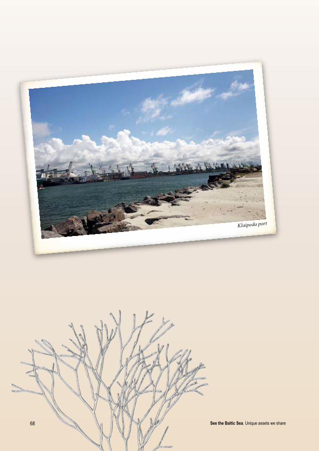
6� See the Baltic Sea. Unique assets we share
Klaipeda port

69See the Baltic Sea. Unique assets we share
9. Problems meet solutions
Longtraditionsandexperience
The Baltic Sea is recognised as one of the most polluted and ecologically threatened seas in the world – excessive emissions of nutrients and toxic chemicals, increasing sea uses such as shipping, oil transportation and related pollution risks, increasing amounts of invasive species, commercial large scale fishery, etc. have left the vulnerable ecosystem of the Baltic Sea in a dangerously unfavourable condition. But at the same time, the alarming status of the sea has raised the awareness of researchers and politicians to take the actions necessary for saving the unique ecosystem of the Baltic Sea which provides us with food and energy as well as space for recreation. As a result the Baltic Sea has become among the best researched seas in the world. It has one of the most advanced environmental protection programs, its international cooperation framework and striving for sustainable development serve as “good practice” examples in other parts of the world. The region has a wide variety of both policy–oriented and technical programs that are working on regional, national, and local levels.
As early as 1974, in Helsinki, the countries around the Baltic Sea jointly signed the “Conven-tion on the Protection of the Marine Environment of the Baltic Sea Area” known as the Hel-sinkiConvention. In 1980 the Baltic Sea Environmental Protection Commission (HELCOM) was established to work on reduction of the pollution. It is an intergovernmental organisation in which all parties to the Helsinki Convention have to contribute to the work of governmental institutions while non–governmental organisations are participating as observers. HELCOM oversees the implementation of the convention’s policies and recommendations that are agreed by all signatory states.
HELCOM meeting – Baltic Sea Action Plan on the way
One of the HELCOM initiatives for protection of marine biodiversity was a proposed network of Baltic Sea Protected Areas (BSPAs), which covers the most significant areas for protection of the HELCOM Red list of Marine and Coastal Biotopes and Biotope Complexes and other important features of marine flora and fauna. The Baltic scientists have defined the borders of BSPAs and analysed their nature values. However BSPAs have not obtained official protection status since

�0 See the Baltic Sea. Unique assets we share
necessary protection measures are in line with designations of marine Natura 2000 sites, which all EU member states are obliged to carry out according requirements of the EC Habitats Directive.
In 2007 HELCOM adopted the BalticSeaActionPlan.6 This document lists the actions and targets for curbing eutrophication, reducing loads of hazardous substances, improving status of marine biodiversity and enabling maritime activities to be carried out in environmentally friendly ways. It also includes series of recommendations on various environmental and sea use aspects.
The environmental protection policy of European Union (EU) has a decisive role for establish-ing legal protection of the marine biodiversity of the Baltic Sea. The EU requirements provided within its directives are binding for all Member States.
The most significant tool for nature conservation in EU is the HabitatsDirective.47 It requires the Member States to establish a network of Special Areas of Conservation (SACs) called Natura 2000 for protection of species and habitats of community importance. Annex I of the directive lists the habitats and Annex II the plant and animal species (mammals, reptiles, amhibians, fish and invertebrates) for protection of which the Natura 2000 sites are established. Annex IV lists the species which also should be protected outside of the Natura 2000 network. Natura 2000 also includes sites called Special Protection Areas (SPAs) designated for protection of birds based on requirements of the BirdsDirective – the oldest nature conservation directive in the EU, adopted in 1979.48
Establishment of the marine Natura 2000 sites is a relatively new process – the Member States were obliged to come up with their proposals of MarineProtectedAreas (MPAs) by the end of 2008. However, in many Member States, among them in the Baltic States, the process has not been finalised since knowledge about the essential marine nature values and their distribution is not yet sufficient.
Improvement of water quality and ecological status in the Baltic Sea, as elsewhere in EU, should be achieved through implementation of such European legal acts as the WaterFrameworkDi-rective (WFD)49 the and MarineStrategyFrameworkDirective (MSFD)50. WFD sets the goal to reach good water quality in all inland and coastal water bodies by 2015. For that purpose river basin management plans have been drawn up which include different measures to reduce the nutrient load in the rivers and other water bodies and to restore water bodies heavily modified by damming up or straightening of rivers, etc. If countries achieve success in implementation of these tasks, the pollution loads from the rivers to the sea will decrease substantially and help to solve the eutrophication problem. The new MSFD adopted in 2008 is the next step addressing the environmental threats of marine ecosystems in an even coherent manner, applying it to territorial waters of the Member States as well as their coastal waters with regard to aspects not covered by the WFD. This directive aims to achieve good environmental status in the marine environment by 2020. For that purpose the member states should develop marine strategies, carry out initial assessment of the current environmental status and impacts of human activities, define environ-mental targets and indicators as well as develop and implement a programme of measures.
Another vital EU policy measure targeted particularly at the Baltic Sea region will be the Strat-egyfortheBalticSeaRegion45. It should promote the Baltic Sea region as a model and pilot region for implementation of EU policy, amongst others, and protection of marine ecosystem and sustainable sea–use principles.
The policy measures are being followed up by variety of international and national projects facili-tating implementation of the policy objectives, increasing the knowledge about the Baltic Sea and
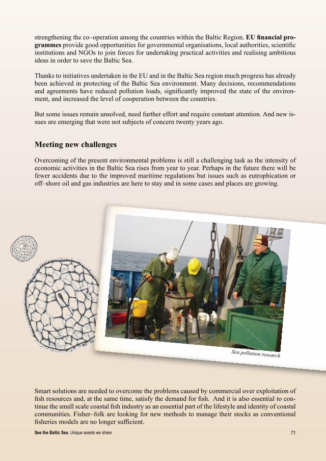
�1See the Baltic Sea. Unique assets we share
strengthening the co–operation among the countries within the Baltic Region. EU financial pro-grammes provide good opportunities for governmental organisations, local authorities, scientific institutions and NGOs to join forces for undertaking practical activities and realising ambitious ideas in order to save the Baltic Sea.
Thanks to initiatives undertaken in the EU and in the Baltic Sea region much progress has already been achieved in protecting of the Baltic Sea environment. Many decisions, recommendations and agreements have reduced pollution loads, significantly improved the state of the environ-ment, and increased the level of cooperation between the countries.
But some issues remain unsolved, need further effort and require constant attention. And new is-sues are emerging that were not subjects of concern twenty years ago.
Meetingnewchallenges
Overcoming of the present environmental problems is still a challenging task as the intensity of economic activities in the Baltic Sea rises from year to year. Perhaps in the future there will be fewer accidents due to the improved maritime regulations but issues such as eutrophication or off–shore oil and gas industries are here to stay and in some cases and places are growing.
Sea pollution research
Smart solutions are needed to overcome the problems caused by commercial over exploitation of fish resources and, at the same time, satisfy the demand for fish. And it is also essential to con-tinue the small scale coastal fish industry as an essential part of the lifestyle and identity of coastal communities. Fisher–folk are looking for new methods to manage their stocks as conventional fisheries models are no longer sufficient.
�2 See the Baltic Sea. Unique assets we share
Climate change is a complex issue involving such challenges as rising sea level, changing weather and water temperature, shifting of species distribution patterns, intensified bad weath-er conditions, etc. Addressing these issues is a task of global scale, but every country must do its part. Moreover by working together, learning and supporting each other, exchanging good practices on how to mitigate the effects of climate change we will greatly increase the prob-ability of a successful result.
Renewable energy is emerging as one of the alternatives to deal with the rapidly changing cli-mate. Wind and wave turbines are becoming more and more popular, although it is important to make sure they do as little harm to the environment as possible.
However, implementing new techniques for resource management and measures for protection of marine environment alone will probably not achieve the desirable result if the citizens of the countries around the Baltic Sea, who are the end users of the many services the sea provides, will not change their minds towards more sustainable ways of living and consuming resources.
Newapproachestothemanagementofseaspaceandresources
In order to deal with existing and upcoming challenges in the Baltic Sea, we first need a much better understanding of the marine ecosystem – how it is functioning, the interactions between its different components and human activities, the effects of eutrophication on species distri-bution – which species are declining and which thriving, and the what’s and why’s of the status and trends of distribution of protected species, etc. Answering these questions requires serious research, which often is very costly. By nature, marine investigations require ship– or airplane–based surveys and sophisticated techniques such as underwater video observations, scuba diving for collection of samples, aerial photo and satellite image analysis, etc. Therefore scientists are joining their forces, establishing interdisciplinary and cross–country teams to cooperate for data collection, development of new research methods or improvement of existing ones, sharing re-sults and jointly assessing results of investigations.
Better knowledge of biological processes and interactions in the marine ecosystem is essential when planning how to organise different sea uses, like shipping, fishery, tourism, wind farms, oil extraction, etc., in a way that has the least harmful effect on marine environment. A commonly accepted tool for balancing all the sea use interests and protection of marine nature values is maritimespatialplanning (MSP). It is a hot issue also in the Baltic Sea where the interest in dif-ferent sea uses and competition for the sea space is rising. Following the recommendations of the EU and HELCOM the MSP is designed to take into account the marine ecosystems and biological processes as a fundamental element in planning and management of the sea.
However, although knowledge and understanding about the functioning of the marine ecosystem is still insufficient, MSP, as well as the establishment of protection measures, has to be undertaken immediately. Accordingly, the planning and management will need to be flexible and adaptive, taking into account uncertainties in such a dynamic system as marine environment. This is called adaptivemanagement. It is seen as a constant learning process – using management not only as a tool to change the system to meet targeted goals, but also as a tool to understand it better.
One of the techniques used by marine scientists to support the planning and management process is modelling–predicting distribution of habitats or species or any other environmental feature based on known environmental conditions, available data on the particular feature and known causal relationships between environmental factors and species distribution.

��See the Baltic Sea. Unique assets we share
Asocioeconomicanalysis of marine ecosys-tem is another key instrument to further our understanding of the Baltic Sea as a whole and to raise awareness and acceptance of en-vironmental protection measures. It helps to get an overview on total costs for managing the marine environment as well as costs for its degradation, and to learn about benefits such as marine ecosystem services (nature resources, water purification, carbon storage etc.) as well as direct incomes to different business sectors, like fishery, tourism, etc. Such analysis helps us to understand that the gain from protecting the marine environ-ment, calculated in monetary value, might be much higher than the administrative costs as well as losses to the economy.
Practicalsolutions
Implementation of all international agreements, directives, cross–border programmes as well as various studies and research is the way towards a healthy and sustainably–used Baltic Sea. The road is long and often most difficult to follow. There are also a few more direct measures that can already be applied by people using the marine ecosystem, in addition to following the regulations that define the minimum environmental standards. One such voluntary measure is using alterna-tive fishing methods to avoid by–catch of birds or seals which will help to preserve the nature values.
Marine researcher takes water sample
Birds are at risk of being by–catched in fishing gears, mostly during migration or wintering peri-ods when they gather in large flocks and feed on fish targeted at the same time by fisherman. At such times, an alternative to the usual gill nets is an option to use long lines – a traditional fish-ing method of coastal fisherman which, in recent years, lost its popularity. It consists of a wicker rope on which hooks with bait are attached, thus there is no net to entangle the birds. It might take more effort to prepare this gear for fishing, but time will be saved on the unpleasant procedure of getting dead birds out of the fishing nets. At the same time it will likely save some extremely rare and globally threatened bird species, e.g. Long–tailed Ducks, Stellers Eiders, etc.
Long lines

�� See the Baltic Sea. Unique assets we share
Another common problem in the Baltic Sea is by–catch of seals in fyke nets – par-ticularly grey seals, whose population has increased a lot during the last years. Seals also like to feed at the fishing nets, often damaging them or drowning. Recently, seals have learned how to get in the fyke net, eat the fish and get out safely, which would be fine from nature conservation point of view, but the catch is lost for the fisherman. To avoid this problem marine researchers have developed a special seal–safe fyke net: at the entrance of the gear there is a grate placed to prevent the seal from getting in, while the net is made of very strong and light material which seals cannot damage. This gear saves seals from drowning and fisherman from losses caused by seals. Purchase of such equipment is more expensive than usual fyke nets, but fisherman can apply for EU subsidies to cover the difference and even benefit in the long term.
Both these methods have been successfully tested and promoted among fishermen within the EU funded LIFE-Nature project “Marine Protected Areas of the Eastern Baltic Sea”. The long line method as a good option for cod fishery was well accepted in Lithuania while the improved seal-safe fyke-net is becoming popular in Estonia.
But this is just one example of how coastal communities can be motivated and evolved in more environmentally friendly management of marine resources. Other possibilities include imple-menting such large scale actions as environmentally friendly agriculture, port development based on high environmental standards, reasonable planning of facilities for tourism and recreation, etc, and simple steps each citizen can undertake.
Seal safe fishing gear
��See the Baltic Sea. Unique assets we share
• reduce nutrient load by limiting use of chemical detergents in our households;• avoid leakage of any washing detergents directly in the sea or other water
body;• empty on-board toilets on yachts and boats only in the special tanks provided
at harbours;• avoid using motor boats and water scooters, especially at important resting
and breeding sites of birds and seals;• don’t litter, and help to improve the marine environment by collecting waste
along the shoreline; • learn about and increase your understanding of the complex ecosystem of the
Baltic Sea and its special values.
A few suggestions for contributing to the improving the status of the Baltic Sea:
It’s up to all of us to save our vital, endangered and precious Baltic Sea.
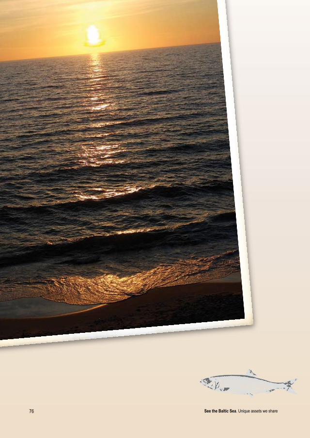
�6 See the Baltic Sea. Unique assets we share

��See the Baltic Sea. Unique assets we share
References
1. HELCOM. 2007. Pearls of the Baltic Sea. Networking for life: special nature in a special sea, Helsinki, Finland, 198. pp. Available online: http://www.helcom.fi/stc/files/Publications/OtherPublications/FINALPearls_of_the_Baltic_Sea.pdf
2. Eberhards G. 2003. Latvijas jūras krasti. morfoloģija, uzbūve, mūsdienu procesi, riska zonas, prognozes, aizsardzība un monitorings: Monogrāfija. Latvijas Universitāte, Rīga, 296 pp. (In Latvian)
3. Eberhards, G., Lapinskis, J. 2008. Process on the Latvian Coast of the Baltic Sea, University of Latvia, Riga, 64 pp.
4. Estonian national Clearning-House Mechanism of Convention on Biological Diversity (CBD-CHM). Available online: http://loodus.keskkonnainfo.ee:88/English/ecological/coast
5. Web Encyclopaedia Estonica. Available online: http://www.estonica.org
6. HELCOM. 2007. HELCOM Baltic Sea Action Plan, Helsinki, Finland, 103 pp. Available online: http://www.helcom.fi/BSAP/en_GB/into/
7. WWF. 2008. 2008 Baltic Sea Scorecard, WWF Baltic Ecoregion Programme, Solna, Sweden, 27 pp. Available online: http://www.wwf.fi/wwf/www/uploads/pdf/balticseascorecard2008.pdf
8. Environmental Conditions in the Baltic Sea Region. Baltic Marine Environment Bibliography. Available online: http://www.baltic.vtt.fi/demo/balful.html
9. AEWA. 2005. 1995-2005: Ten years taking care of travelling waterbirds. Bonn, Germany, 40 pp. Available online: http://www.unep-aewa.org/publications/10th_anniversary_borchure_english.pdf
10. BirdLife International. 2004. Birds in Europe: population estimates, trends and conservation status. Cambridge, UK. (BirdLife Conservation Series No. 12).
11. BirdLife International home page. Available online: www.birdlife.org
12. Young People’s Trust for the Environment home page. Available online: ww.ypte.org.uk
13. Blab J., Riecken U., Ssymank A., 1995. Proposal on a Criteria System for a National Red Data Book of Biotopes, Landscape Ecology, Volume 10 (1), 41-50 p.
14. Coastal portal. Biotopes and classification systems. Available online: http://www.coastalwiki.org/coastalwiki/Biotopes_and_classification_systems
15. HELCOM. 1998. Red List of marine and coastal biotopes and biotope complexes of the Baltic Sea, Belt Sea and Kattegat. Balt.Sea Environ. Proc., No 75. 115 pp.
�� See the Baltic Sea. Unique assets we share
16. Martin, G., Möller, T., Kotta, J., Daynus, D., Aigars, J., Bucas, M., Jermakovs, V., Siaulys, A., Saskov, A., 2010. Benthic Marine Habitats of the Eeastern Baltic Sea. Estonian Marine Institue Report Series nr. 15.
17. Seal Conservation Society home page. Available online: http://www.pinnipeds.org/speciesS/species.htm
18. Estonian Ministry of Environment. 2004. Internationally important species in Estonia: Natura 2000, Tallinn
19. Jüssi, I., Jüssi, M., Müür, R. 2004. Tegevuskava Läänemere viigerhülge (Phoca hispida bothnica) kaitseks Eesti rannikul aastatel 2006-2010. (Action plan for protection of the Baltic Ringed Seal on Estonian coast in 2006-2010)
20. HELCOM. Halichoerus grypus, Grey Seal (Phocidae). Available online: http://www.helcom.fi/environment2/biodiv/endangered/en_GB/fact_sheets/#7. Mammals
21. Jüssi, I., Jüssi, M. 2007. Tegevuskava hallhüljeste kaitse korraldamiseks Eestis aastatel 2007-2011.Tallinn (Action plan for protection of the Grey Seals in Estonia in 2007-2011)
22. Ascobans home page. Available online: http://www.ascobans.org
23. Coalition Clean Baltic. The Baltic Harbour porpoise needs protection. Available online: http://www.ccb.se/documents/Harbourporpoise.pdf
24. The Hebridean Whale and Dolphin Trust home page. Available online: http://www.whaledolphintrust.co.uk/whales_dolphins/harbour-porpoise.asp
25. Dolphin Fund: we live to let live. Available online: http://www.dolphinfund.eu
26. Hallanaro E.-L., PylvänääM., Spunģis V. 2002. Nature in Northern Europe – Biodiversity in achanging environment. Nord 2001:13, Nordic Council of Ministers, Copenhagen, 350 pp.
27. Enciklopēdija „Latvijas Daba“. 2007. Gandrs, Rīga. Available online: http://www.latvijasdaba.lv/
28. Stwart R. 2009. Our Ocean Planet Oceanography in the 21st Century. Marine Fisheries Food Webs (draft). Available online: http://oceanworld.tamu.edu/resources/oceanography-book/marinefoodwebs.htm
29. Finnish Environmental Institute. The Baltic Sea Portal. Available online: http://www.fimr.fi
30. Encyclopædia Britannica. Available online: http://www.britannica.com/
31. Corey T., Beutel D. The Marine Food Web. Rhode Island Sea Grant Fact sheet. Available online: http://seagrant.gso.uri.edu/factsheets/foodweb.html
32. Bučas J. 2001. The National Park of the Curonian Spit. Kultūros paveldo fondas, Savastis, Vilnius, 474 pp.
33. Viimsi Museums home page. Available online: http://viimsimuuseumid.ee
34. Estoanian national Museum home page. Coastal Swedes. Available online: http://www.erm.ee
35. Käsmu Sea Museum homepage. Available online: http://www.kasmu.ee
36. Estonian Historic Ship Society homepage. Available online: http://www.historicships.ee

�9See the Baltic Sea. Unique assets we share
37. Latvijas Kultūras fonds. Vikingu ceļš Daugavas ekspedīcija. Available online: http://www.lkf.lv/vikingi/LAT/vikings.html
38. K. Voveris. 2009. Report on cargo handling in Klaipeda State Seaport in the year 2008, Klaipeda state seaport authority, 58 pp.
39. HELCOM. Overview of the Shipping traffic in the Baltic Sea. Available online: http://www.helcom.fi/stc/files/shipping/Overview%20of%20ships%20traffic_updateApril2009.pdf
40. Baltic sea 2020 home page. Available online: http://www.balticsea2020.org/
41. HELCOM. 2006. Maritime Transport in the Baltic Sea. Draft HELCOM Thematic Assessment in 2006. Helsinki, Finland, 24 pp. Available online: http://helcom.navigo.fi/stc/files/BSAP/FINAL%20Maritime.pdf
42. Baltic 21. 2006. Baltic 21 Report 2003-2005. Realising a Common Vision of a Baltic Sea Eco-Region. Baltic 21 Series No. 1/2006, 24 pp. Available online: http://www.baltic21.org/attachments/baltic_21_report_1_2006__triennial_report_2003_2005.pdf
43. Langdon D. C. 2008. Energy profile of the Baltic Sea region. The Encyclopaedia of Earth. Available online: http://www.eoearth.org/article/Energy_profile_of_the_Baltic_Sea_region
44. European Commission. EU Strategy for the Baltic Sea Region. Available online: http://ec.europa.eu/regional_policy/cooperation/baltic/index_en.htm
45. Kloff S. and Wicks C. 2004. Environmental management of offshore oil development and maritime oil transport. IUCN Commission on Environmental, Economic and Social Policy. Available online: http://cmsdata.iucn.org/downloads/offshore_oil_eng.pdf
46. Impacts on Marine Mammals and Sea Birds. Portal - Wind Energy. The Facts. Available online: http://www.wind-energy-the-facts.org
47. Council Directive 92/43/EEC of 21 May 1992 on the conservation of natural habitats and of wild fauna and flora, Available online: http://ec.europa.eu/environment/nature/legislation/index_en.htm
48. Council Directive 79/409/EEC of 2 April 1979 on the conservation of wild birds. Available online: http://ec.europa.eu/environment/nature/legislation/index_en.htm
49. Directive 2000/60/EC of the European Parliament and of the Council establishing a framework for the Community action in the field of water policy. Available online: http://ec.europa.eu/environment/water/water-framework/index_en.html
50. Directive 2008/56/EC of the European Parliament and of the Council of 17 June 2008 establishing a framework for community action in the field of marine environmental policy. Available online: http://ec.europa.eu/environment/water/marine/index_en.htm

�0 See the Baltic Sea. Unique assets we share
Project partners
LeadPartner:Baltic Environmental Forum – Latvia
Estonia:Baltic Environmental Forum – EstoniaEstonian Environmental Information CentreEstonian Marine Institute, University of Tartu Estonian Ornithological SocietyEnvironmental Board
Latvia:Marine and Inland Waters AdministrationThe National Armed Forces of Republic of LatviaInstitute of Aquatic EcologyLatvian Ornithological SocietyLatvian Fish Resources AgencyVides Filmu Studija LdtSocially Oriented Project Agency
Lithuania:Baltic Environmental Forum – LithuaniaInstitute of Ecology, Vilnius UniversityCoastal Research and Planning Institute, Klaipėda UniversityCentre of Marine Research
Otherpartners:Baltic Fund for Nature of St.Petersburg Naturalists Society, RussiaBirdlife International“Metsähallitus” Natural Heritage Services, FinlandFederal Agency for Nature Conservation, Germany
The project is financially supported by:European Commission LIFE – Nature ProgrammeEnvironmental Investment Centre, EstoniaMinistry of Environment, LatviaMinistry of Environment, FinlandThe Nordic Council of MinistersMinistry of National Defence, Lithuania
Projectwebpage:www.balticseaportal.net