North American Profile of ISO19115:2003 - Geographic ......Jul 26, 2007 · Natural Resources...
290
Date: July 26, 2007 North American Profile of ISO19115:2003 - Geographic information – Metadata (NAP – Metadata, version 1.1) Profil nord américain – ISO19115:2003 – Information géographique– Metadonnées (PNA – Métadonnées, version 1.1)
Transcript of North American Profile of ISO19115:2003 - Geographic ......Jul 26, 2007 · Natural Resources...

Date: July 26, 2007
North American Profile of ISO19115:2003 - Geographic information – Metadata (NAP – Metadata, version 1.1) Profil nord américain – ISO19115:2003 – Information géographique– Metadonnées (PNA – Métadonnées, version 1.1)


NAP – Metadata, version 1.1
NAP – Metadata Working Group
Canada:
Dr. Jean Brodeur (co-editor)
Natural Resources Canada, Centre for Topographic Information 2144-010 rue King W. St., Sherbrooke QC J1J 2E8 Phone: 819.564.5600 ext. 251 Email: [email protected]
Dr. Mohamed Habbane Natural Resources Canada, Geoconnections 615 Booth Street, Ottawa, ON K1A 0E9 Phone: 613.947.1309 Email: [email protected]
Mr. Raphael Sussman Land Information Ontario 300 Water Street, 2nd Floor North, Peterborough, ON K9J 8M5 Phone: 705.755.2321 Email: [email protected]
Mr. Peter Rushforth Natural Resources Canada, GeoConnections 615 Booth Street, Ottawa, ON K1A 0E9 Phone: 613.943.0784 Email: [email protected]
USA:
Mrs. Sharon Shin (co-editor)
Metadata Coordinator, Federal Geographic Data Committee Secretariat Denver Federal Center, P.O. Box 25046 Mail Stop 302, Building 810 Room 8000, Denver, Colorado 80225-0946 Phone: 303.202.4230 Email: [email protected]
Mr. David M. Danko Environmental Systems Research Institute Inc. 8615 Westwood Center Drive, Vienna, VA 22182-2214 Phone: 703.506.9515 ext. 8011 Email: [email protected]
Prof. Harold Moellering Ohio State University, Geography Department 1036 Derby Hall, 154 N.Oval Mall, Ohio State University, Columbus, OH 43210 Fax: 614.292.2608 Email: [email protected]
Mr. Shawn M. Silkensen Lockheed Martin Corp. 15050 Conference Center Drive, Chantilly, VA 20151 Phone: 703.460.3406 Email: [email protected]
Mr. Bruce Westcott Geospatial Metadata Consultant 3393 Main Street, Cabot, Vermont 05647 Phone: 802.426.3344 Email: [email protected]

NAP – Metadata, version 1.1
i
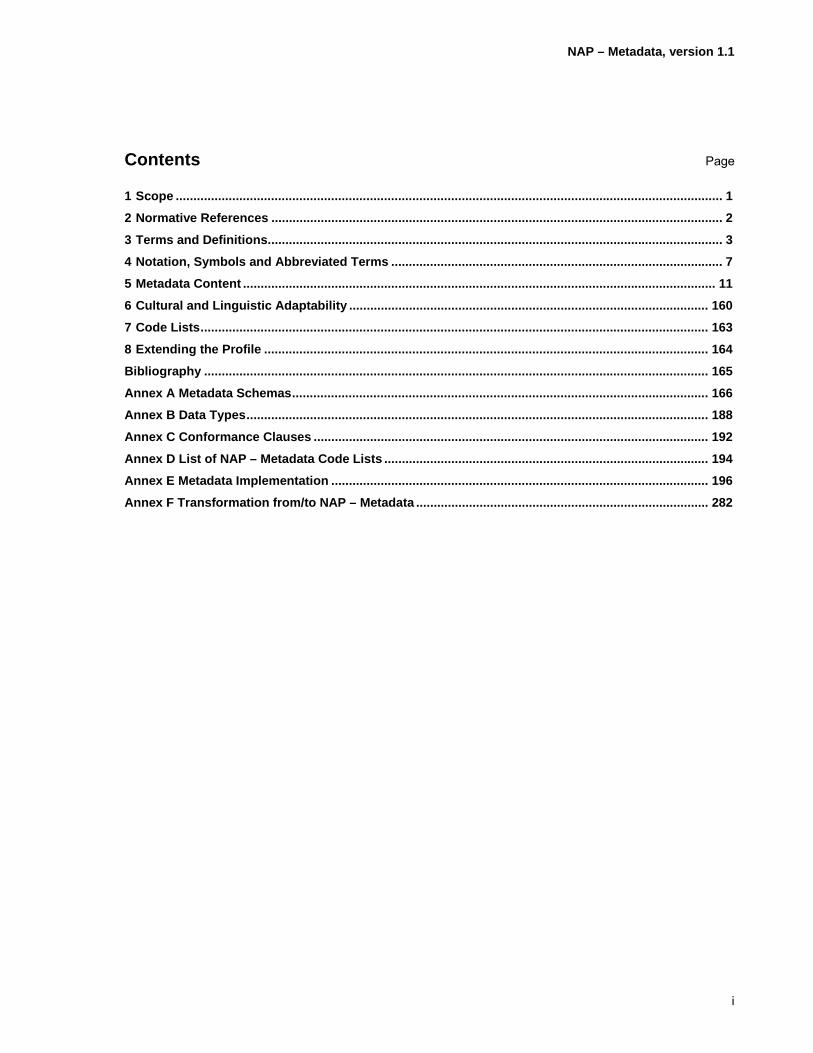
Contents Page
1 Scope ........................................................................................................................................................... 1 2 Normative References ................................................................................................................................ 2 3 Terms and Definitions................................................................................................................................. 3 4 Notation, Symbols and Abbreviated Terms .............................................................................................. 7 5 Metadata Content ...................................................................................................................................... 11 6 Cultural and Linguistic Adaptability ...................................................................................................... 160 7 Code Lists................................................................................................................................................ 163 8 Extending the Profile .............................................................................................................................. 164 Bibliography ............................................................................................................................................... 165 Annex A Metadata Schemas...................................................................................................................... 166 Annex B Data Types................................................................................................................................... 188 Annex C Conformance Clauses ................................................................................................................ 192 Annex D List of NAP – Metadata Code Lists ............................................................................................ 194 Annex E Metadata Implementation ........................................................................................................... 196 Annex F Transformation from/to NAP – Metadata ................................................................................... 282
NAP – Metadata, version 1.1
ii
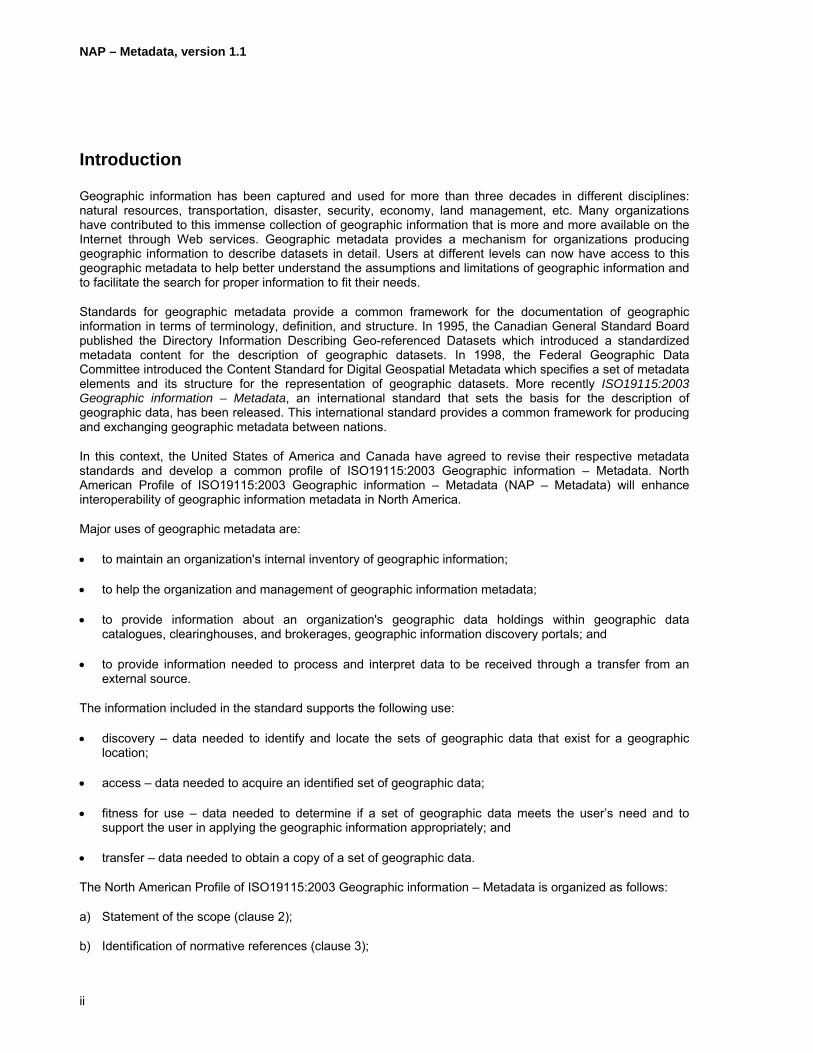
Introduction
Geographic information has been captured and used for more than three decades in different disciplines: natural resources, transportation, disaster, security, economy, land management, etc. Many organizations have contributed to this immense collection of geographic information that is more and more available on the Internet through Web services. Geographic metadata provides a mechanism for organizations producing geographic information to describe datasets in detail. Users at different levels can now have access to this geographic metadata to help better understand the assumptions and limitations of geographic information and to facilitate the search for proper information to fit their needs.
Standards for geographic metadata provide a common framework for the documentation of geographic information in terms of terminology, definition, and structure. In 1995, the Canadian General Standard Board published the Directory Information Describing Geo-referenced Datasets which introduced a standardized metadata content for the description of geographic datasets. In 1998, the Federal Geographic Data Committee introduced the Content Standard for Digital Geospatial Metadata which specifies a set of metadata elements and its structure for the representation of geographic datasets. More recently ISO19115:2003 Geographic information – Metadata, an international standard that sets the basis for the description of geographic data, has been released. This international standard provides a common framework for producing and exchanging geographic metadata between nations.
In this context, the United States of America and Canada have agreed to revise their respective metadata standards and develop a common profile of ISO19115:2003 Geographic information – Metadata. North American Profile of ISO19115:2003 Geographic information – Metadata (NAP – Metadata) will enhance interoperability of geographic information metadata in North America.
Major uses of geographic metadata are:
• to maintain an organization's internal inventory of geographic information;
• to help the organization and management of geographic information metadata;
• to provide information about an organization's geographic data holdings within geographic data catalogues, clearinghouses, and brokerages, geographic information discovery portals; and
• to provide information needed to process and interpret data to be received through a transfer from an external source.
The information included in the standard supports the following use:
• discovery – data needed to identify and locate the sets of geographic data that exist for a geographic location;
• access – data needed to acquire an identified set of geographic data;
• fitness for use – data needed to determine if a set of geographic data meets the user’s need and to support the user in applying the geographic information appropriately; and
• transfer – data needed to obtain a copy of a set of geographic data.
The North American Profile of ISO19115:2003 Geographic information – Metadata is organized as follows:
a) Statement of the scope (clause 2);
b) Identification of normative references (clause 3);

NAP – Metadata, version 1.1
iii
c) Terms and definitions (clause 4);
d) Symbols and abbreviated terms (clause 5);
e) Content of the profile (clause 6);
f) Cultural and linguistic adaptability (clause 7);
g) Code lists and metadata register (clause 8 and 9).


NAP – Metadata, version 1.1
1
North American Profile of ISO19115:2003 - Geographic information - Metadata
1 Scope
The North American Profile of ISO19115:2003 Geographic information – Metadata is intended to identify geospatial metadata that are needed for North American organizations to describe their geospatial data, including dataset and dataset series, and related Web services. It is based on ISO19115:2003 Geographic information – Metadata and ISO19106:2004 Geographic information – Profiles. It also includes service metadata from ISO19119:2005 Geographic information – Services and implementation perspectives from ISO/TS19139:2007 Geographic information – Metadata – XML schema implementation. As outlined in ISO19106:2004 Geographic Information – Profiles, it satisfies conformance Class 1 since it defines a pure subset of ISO19115:2003 Geographic information – Metadata and ISO19119:2005 Geographic information – Services. Retained metadata elements have been selected to enhance support to geographic information discovery within the context of North America and to minimize authorized duplications. The extension of code lists is also intended to enhance support to geographic information discovery. Annex A provides the adjustments made to the ISO19115:2003 Geographic information – Metadata and ISO19119:2005 Geographic information – Services UML models.
This profile intends to be an inclusive document addressing ISO19115:2003 Geographic information – Metadata and the accepted modifications. It is presented in a manner to support the capture and use of geospatial metadata consistently. As such, it includes best practices to guide data providers in capturing geospatial metadata. To that end, it supports interoperability of geospatial information as it provides a common framework for the description and representation of metadata. In addition, this profile provides a mechanism to support cultural and linguistic adaptability by enabling representation of free text in multiple languages and by introducing a metadata register describing metadata in multiple languages (e.g. English and French) compliant to ISO19135:2005 Geographic information – Procedures for item registration.
Note: Parts of ISO19110:2005 Geographic information – Methodology for feature cataloguing and ISO/FDIS19111rev. Geographic information – Spatial referencing by coordinates are covered as needed.

NAP – Metadata, version 1.1
2
2 Normative References
ISO639-2, Codes for the representation of names of languages - Part 2: alpha-3 code
ISO3166-1, Codes for the representation of names of countries and their subdivisions - Part 1: Country codes
ISO/TS19103:2005, Geographic information - Conceptual schema language
ISO19106:2004, Geographic information – Profiles
ISO19107:2003, Geographic Information – Spatial schema
ISO19108:2002, Geographic Information – Temporal schema
ISO19109:2005, Geographic Information – Rules for application schema
ISO19110:2005, Geographic Information – Methodology for feature cataloguing
ISO/FDIS19111rev., Geographic information – Spatial referencing by coordinates
ISO19113:2002, Geographic Information – Quality principles
ISO19114:2003, Geographic Information – Quality evaluation procedures
ISO19115:2003, Geographic information – Metadata
ISO19115:2003/Cor.1:2006, Geographic information – Metadata, Technical corrigendum 1
ISO19118:2005, Geographic information – Encoding
ISO19119:2005, Geographic information – Services
ISO19119:2005 PDAM 1, Geographic information – Services
ISO/TS19127:2005 Geographic information – Geodetic codes and parameters
ISO19133:2005, Geographic Information – Location-based services – Tracking and navigation
ISO19135:2005, Geographic information – Procedures for item registration
ISO/DIS19136, Geographic information – Geography Markup Language
ISO/TS19139:2007, Geographic information – Metadata - XML schema implementation
OGC 05-008, OpenGIS® Web Services Common Specification

NAP – Metadata, version 1.1
3
3 Terms and Definitions
For the purposes of this document, the following terms and definitions apply.
3.1 aggregate dataset
a dataset which is comprised of two or more component datasets
Note: An aggregate dataset from may inherit one or more characteristics.
3.2 application profile
identification of clauses, classes, subsets, options, and parameters from base standards that are necessary for accomplishing a particular function
3.3 application schema
conceptual schema for data required by one or more applications [ISO19101]
3.4 attribute
named property of an entity [ISO/IEC2382]
3.5 class
description of a set of objects that share the same attributes, operations, methods, relationships, and semantics [ISO/TS19103]
3.6 client
software component that can invoke an operation from a server [ISO19128]
3.7 conceptual model
model that defines concepts of a universe of discourse [ISO19101]
3.8 conceptual schema
formal description of a conceptual model [ISO19128]
3.9 dataset
identifiable collection of data [ISO19115]
3.10 dataset series
NAP – Metadata, version 1.1
4
collection of datasets sharing the same product specification [ISO19115]
3.11 dimension
variable required to represent a position in the space. For example, two variables – x and y – are needed to locate a point on a plane (e.g. a building on a City map)
3.12 geographic dataset
dataset with features depicted with implicit or explicit reference to a location relative to the Earth
3.13 geographic information
information concerning phenomena implicitly or explicitly associated with a location relative to the Earth [ISO19101]
3.14 identifier
linguistically independent sequence of characters capable of uniquely and permanently identifying that with which it is associated [ISO19135]
3.15 instantiable/non-instantiable
capable /or not to represent an abstraction by the creation of a concrete instance or to create the ability to create an instance [adapted from ISO19133]
3.16 interface
named set of operations that characterize the behaviour of an entity [ISO19119]
3.17 metaclass
a class whose instances are classes
3.18 metadata component
a constituent part of a metadata main item or a metadata subitem. It can specialize or aggregate another metadata component
3.19 metadata element
a discrete unit of metadata [ISO19115]
3.20 metadata entity
a set of metadata elements describing the same aspect of data [ISO19115]

NAP – Metadata, version 1.1
5
Note: It consists of a set of attributes which describes an aspect of a resource [NAP - Metadata clarification of ISO19115].
3.21 metadata main item
metadata element which is of primary interest in the context
3.22 metadata subitem
a subordinate of a metadata main item
3.23 metadata schema
conceptual schema describing metadata [ISO19101]
3.24 metadata section
subset of metadata that defines a collection of related metadata entities and elements [ISO19115]
3.25 method
implementation of an operation
3.26 multiplicity
specification of the range of allowable cardinalities that a set may assume
3.27 operation
specification of a transformation or query that an object may be called to execute [ISO19119]
3.28 parameter
variable used to express a value in an operation request or response
3.29 portrayal
presentation of information to humans [ISO19117]
3.30 portrayal catalogue
collection of all defined portrayals [ISO19117]

NAP – Metadata, version 1.1
6
3.31 request
invocation of an operation by a client [ISO19128]
3.32 response
result of an operation returned from a server to a client [ISO19132]
3.33 schema
formal description of a model [ISO19101]
3.34 server
a particular instance of a service [ISO19128]
3.35 service
distinct part of the functionality that is provided by an entity through interfaces [ISO19119]
NAP – Metadata, version 1.1
7
4 Notation, Symbols and Abbreviated Terms
4.1 Notation
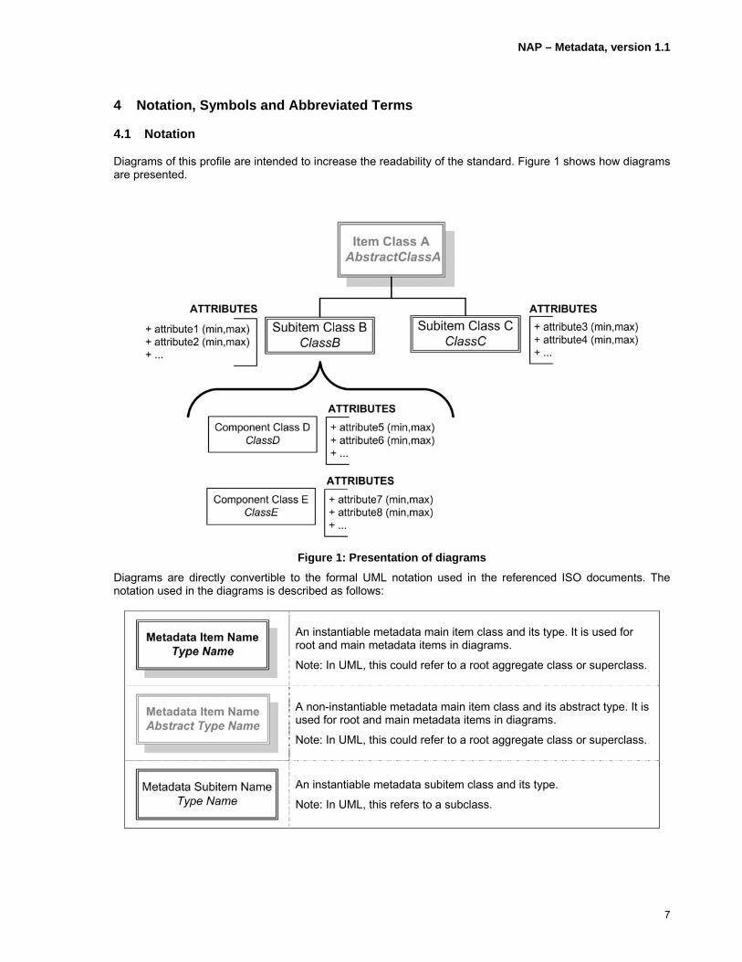
Diagrams of this profile are intended to increase the readability of the standard. Figure 1 shows how diagrams are presented.
Figure 1: Presentation of diagrams
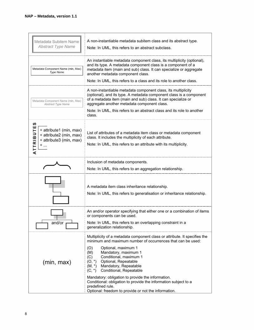
Diagrams are directly convertible to the formal UML notation used in the referenced ISO documents. The notation used in the diagrams is described as follows:
An instantiable metadata main item class and its type. It is used for root and main metadata items in diagrams.
Note: In UML, this could refer to a root aggregate class or superclass.
A non-instantiable metadata main item class and its abstract type. It is used for root and main metadata items in diagrams.
Note: In UML, this could refer to a root aggregate class or superclass.
An instantiable metadata subitem class and its type.
Note: In UML, this refers to a subclass.
NAP – Metadata, version 1.1
8
A non-instantiable metadata subitem class and its abstract type.
Note: In UML, this refers to an abstract subclass.
An instantiable metadata component class, its multiplicity (optional), and its type. A metadata component class is a component of a metadata item (main and sub) class. It can specialize or aggregate another metadata component class.
Note: In UML, this refers to a class and its role to another class.
A non-instantiable metadata component class, its multiplicity (optional), and its type. A metadata component class is a component of a metadata item (main and sub) class. It can specialize or aggregate another metadata component class.
Note: In UML, this refers to an abstract class and its role to another class.
List of attributes of a metadata item class or metadata component class. It includes the multiplicity of each attribute.
Note: In UML, this refers to an attribute with its multiplicity.
Inclusion of metadata components.
Note: In UML, this refers to an aggregation relationship.
A metadata item class inheritance relationship.
Note: In UML, this refers to generalisation or inheritance relationship.
An and/or operator specifying that either one or a combination of items or components can be used.
Note: In UML, this refers to an overlapping constraint in a generalization relationship.
Multiplicity of a metadata component class or attribute. It specifies the minimum and maximum number of occurrences that can be used:
(O) Optional, maximum 1 (M) Mandatory, maximum 1 (C) Conditional, maximum 1 (O, *) Optional, Repeatable (M, *) Mandatory, Repeatable (C, *) Conditional, Repeatable
Mandatory: obligation to provide the information. Conditional: obligation to provide the information subject to a predefined rule. Optional: freedom to provide or not the information.
NAP – Metadata, version 1.1
9
Note: In UML, this refers to multiplicity.
Additionally, best practices document the structure and format of some free text fields when they include multiple information. The notation used is as follow:
Field Element: Description:
<aValue> A value of the type specified within the angle brackets. For example, “fra” is an acceptable value for <ISO639-2/T three letter language code>.
<;> A character specified within the angle brackets typically used to separate values. <;> stands for a semicolon separator.
<blank space> A blank space character as specified within the angle brackets.
{} A content part of the free text field that is optional. It may include values, separators, or blank spaces.
4.2 Symbols and Abbreviated Terms
BP Best Practice
CI_ Citation
DC Dublin Core
DCMI Dublin Core Metadata Initiative
DQ_ Data Quality
DS_ Dataset
FGDC Federal Geographic Data Committee
EX_ Extent
GF_ Geographic Feature
GML Geography Markup Language
GM_ Geometry
HTTP HyperText Transfer Protocol
ISO International Organization for Standardization
LI_ Lineage
MD_ Metadata
NAP – Metadata North American Profile of ISO19115:2003 Geographic information – Metadata
OGC Open Geospatial Consortium Inc.
NAP – Metadata, version 1.1
10
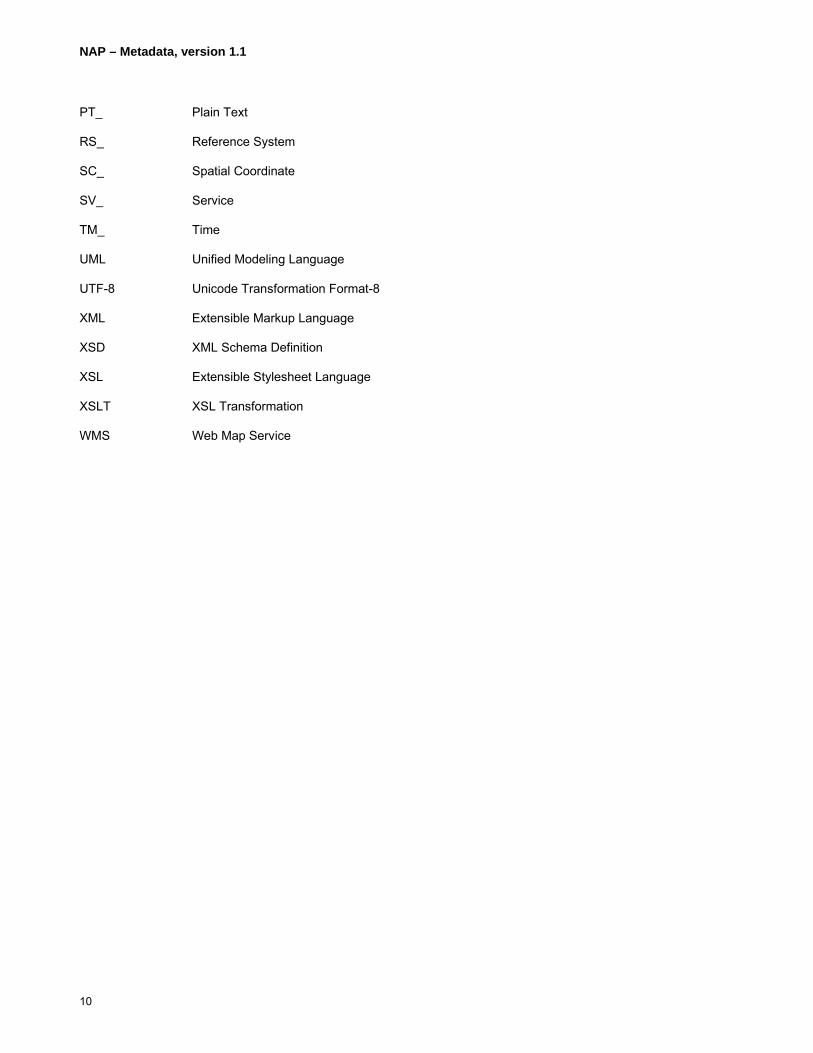
PT_ Plain Text
RS_ Reference System
SC_ Spatial Coordinate
SV_ Service
TM_ Time
UML Unified Modeling Language
UTF-8 Unicode Transformation Format-8
XML Extensible Markup Language
XSD XML Schema Definition
XSL Extensible Stylesheet Language
XSLT XSL Transformation
WMS Web Map Service
NAP – Metadata, version 1.1
11
5 Metadata Content
5.1 Introduction
This clause presents the metadata elements of NAP – Metadata. It begins with the description of the overall metadata entity set, which is the root of a metadata description, and is followed by the various attributes and components that are included in it. Either attributes or components are described by simple types (e.g. integer, free text, etc.) or types composed of other attributes and components. The designation of metadata elements is according to ISO19115:2003 Geographic information – Metadata and ISO19119:2005 Geographic information – Services.
Annex A provides the UML representation of the metadata elements of this profile including the adjustments made to ISO19115:2003 Geographic information – Metadata and ISO19119:2005 Geographic information – Services.
Clause 9, NAP-Metadata Register, introduces the authoritative repository used to host the metadata items used within the NAP Metadata Profile. This registry not only supports each item used within this document it also provides code list values referenced within this document to include the various languages supported by the register.

NAP – Metadata, version 1.1
12
5.2 Metadata Record Information
The following attributes (5.2.1 – 5.2.11) describe the metadata. It is followed by the components (5.2.12 – 5.2.21) to describe the resource. Attributes and components are presented here briefly and later fully described beginning in 5.3.
Type: MD_Metadata
Description: Attributes which describe the metadata and the components to describe the resource.
Figure 2: Metadata record information

NAP – Metadata, version 1.1
13
Clause No
Name/ RoleName Multiplicity Type Description Best Practices
5.2.1 fileIdentifier M free text (CharacterString) A unique phrase or string which uniquely identifies the metadata file.
Each metadata record shall have a universal unique identifier (UUID) to distinguish it from others.
5.2.2 language M free text (CharacterString) Language of the metadata composed of an ISO639-2/T three letter language code and an ISO3166-1 three letter country code.
The language code and country code are documented in the following manner: <ISO639-2/T three letter language code><;><blank space><ISO3166-1 three letter country code> Language code is given in lowercase. Country code is given in uppercase. e.g. fra; CAN This attribute constitutes the primary language of free text attributes. When more than one language is used in the metadata, then the attribute locale (see 5.2.11) is mandatory. See also clause 6.2. Note: see http://www.loc.gov/standards/iso639-2/php/English_list.php for ISO639-2/T language codes; see http://userpage.chemie.fu-berlin.de/diverse/doc/ISO_3166.html for ISO3166-1 country codes.
5.2.3 characterSet M CodeList napMD_CharacterSetCode
Character coding standard in the metadata.
The character set for the metadata representation is restricted to “utf8.”
5.2.4 parentIdentifier C free text (CharacterString) The unique name of the file or associated fileIdentifier, related in higher hierarchy to the file.
parentIdentifier is documented when the hierarchy of a higher level exists. If there is more than one parent see Aggregation Information (5.3.1.19)

NAP – Metadata, version 1.1
14
5.2.5 hierarchyLevel M,Repeatable CodeList napMD_ScopeCode Dataset level to which the metadata applies.
Default repeatability is 1. If hierarchy is unknown, default value is “dataset.” Select hierarchyLevel from napMD_ScopeCode. The parent record of a resource will most commonly be a Series (6.20) sharing many of the characteristics of that record such as theme, source, date, resolution, methodology, or distributor. When a parent record exists, it is not necessary to repeat all elements for each child records. If a record is associated with more than one parent it is recommended that the respective parents be assigned distinct hierarchy levels or defined as an aggregation (6.3.2.20).
5.2.6 contact M,Repeatable CI_ResponsibleParty (see 5.16) The responsible party for the metadata content.
The organization directly responsible for metadata maintenance. Contact information (see 5.16.4 contactInfo) shall be provided.
5.2.7 dateStamp M Date (see B.4) Metadata creation date. Date of metadata creation or the last metadata update.
5.2.8 metadataStandardName M free text (CharacterString) Name of the metadata standard/profile used.
Default value to “NAP – Metadata.”
5.2.9 metadataStandardVersion O free text (CharacterString) Version of the metadata standard/profile used.
Default value NAP – Metadata version used.
5.2.10 dataSetURI O free text (CharacterString) Uniform Resource Identifier for the dataset along with its on line function code.
The dataSetURI is documented in two parts in the following manner: <Uniform Resource Identifier><;><blank space>< onLineFunctionCode > The on line function code is optional. Select onLineFunctionCode from napCI_OnLineFunctionCode.
5.2.11 locale C,Repeatable PT_Locale (see 6.2) Other languages used in Mandatory when more than one language is

NAP – Metadata, version 1.1
15
metadata free text description.
used in free text descriptions. The character encoding shall be set to “utf8.”
Note: The following metadata elements (5.2.12 – 5.2.21) are the components to describe the resource.
5.2.12 Identification Information M,Repeatable MD_DataIdentification (see 5.3.1) and/or SV_ServiceIdentification (see 5.3.2)
Basic information about the dataset.
MD_Identification is an abstract class; identification information can only be instantiated via MD_DataIdentification and/or SV_ServiceIdentification.
5.2.13 Metadata Constraint Information
O,Repeatable MD_Constraints (see 5.4.1) and/or MD_LegalConstraints (see 5.4.2) and/or MD_SecurityConstraints (see 5.4.3).
Describes the use, legal, and security constraints on the use of the metadata.
Multiple constraints can be reported as needed.
5.2.14 Data Quality Information O,Repeatable DQ_DataQuality (see 5.5) Data quality information for the resource.
5.2.15 Metadata Maintenance Information
O MD_MaintenanceInformation (see 5.6)
Information about metadata update.
5.2.16 Spatial Representation Information
O,Repeatable MD_GridSpatialRepresentation (see 5.7.1) and/or MD_VectorSpatialRepresentation (see 5.7.2) and/or MD_Georectified (see 5.7.3) and/or MD_Georeferenceable (see 5.7.4)
Digital representation of vector and/or grid objects in the dataset.
MD_SpatialRepresentation is an abstract class. Spatial representation information can be instantiated only via MD_VectorSpatialRepresentation and/or MD_GridSpatialRepresentation and/or MD_Georectified and/or MD_Georeferenceable.
5.2.17 Reference System Information
C,Repeatable MD_ReferenceSystem (see 5.8) Description of the spatial and/or temporal reference systems used in the dataset.
Conditional, if spatialRepresentionType in MD_DataIdentification is “vector”, “raster” or “tin.” Multiple instances of Reference System Information are authorized to describe the coordinate systems being used for coordinate representation (horizontal, vertical and/or temporal).
5.2.18 Content Information O,Repeatable MD_FeatureCatalogueDescription (see 5.9.1) and/or {MD_CoverageDescription (see
Characteristics describing the feature catalogue, the coverage, and the image
MD_ContentInformation is an abstract class. Content information can only be instantiated via MD_FeatureCatalogueDescription and/or
NAP – Metadata, version 1.1
16
5.9.2) or MD_ImageDescription (see 5.9.3)}
data. MD_CoverageDescription or MD_ImageDescription.
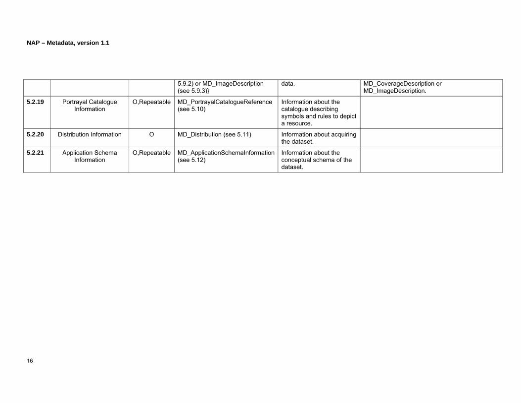
5.2.19 Portrayal Catalogue Information
O,Repeatable MD_PortrayalCatalogueReference (see 5.10)
Information about the catalogue describing symbols and rules to depict a resource.
5.2.20 Distribution Information O MD_Distribution (see 5.11) Information about acquiring the dataset.
5.2.21 Application Schema Information
O,Repeatable MD_ApplicationSchemaInformation (see 5.12)
Information about the conceptual schema of the dataset.

NAP – Metadata, version 1.1
17
(Page intentionally left blank)
NAP – Metadata, version 1.1
18
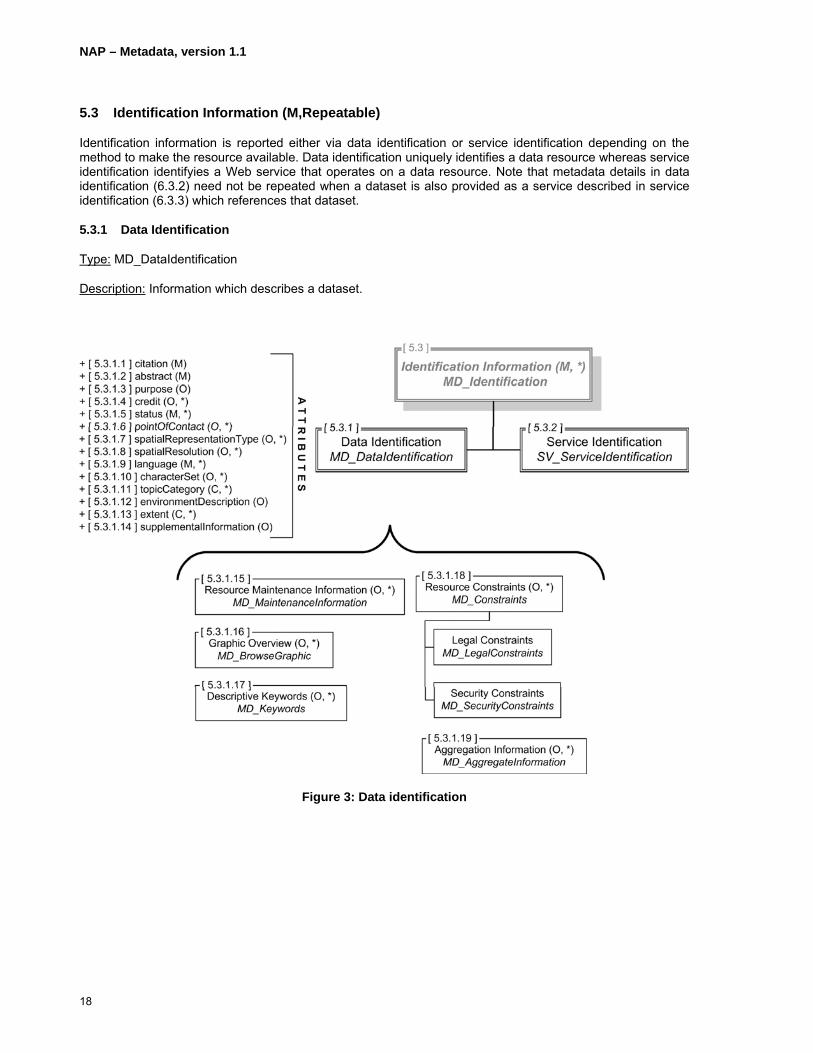
5.3 Identification Information (M,Repeatable)
Identification information is reported either via data identification or service identification depending on the method to make the resource available. Data identification uniquely identifies a data resource whereas service identification identifyies a Web service that operates on a data resource. Note that metadata details in data identification (6.3.2) need not be repeated when a dataset is also provided as a service described in service identification (6.3.3) which references that dataset.
5.3.1 Data Identification
Type: MD_DataIdentification
Description: Information which describes a dataset.
Figure 3: Data identification

NAP – Metadata, version 1.1
19
Clause No
Name/ RoleName Multiplicity Type Description Best Practices
5.3.1.1 citation M CI_Citation (see 5.14) Citation for the dataset. The attribute citedResponsibleParty in CI_Citation shall be reported at least once. Contact information (see 5.16.4 contactInfo) for the cited responsible party shall also be provided (e.g. at least the distributor could be identified). The metadata is always valid at the date identified in dateStamp (5.2.7) even if the responsible party no longer exists. The date of the resource reported in the citation (i.e. citation date, see 5.14.3) corresponds to the resource’s last update version according to its update frequency (see 5.6.1) and the date of next update (see 5.6.2) of its previous version.
5.3.1.2 abstract M free text (CharacterString) Brief narrative summary of the dataset’s contents.
Abstract narrative should include information on general content, thematic features (e.g., geology; climatology; etc.), and features; dataset application: GIS, CAD, image, database; geographic coverage: county/city name; time period of content: begin and end date or single date; and special data characteristics or limitations.
5.3.1.3 purpose O free text (CharacterString) Summary of the intentions for which the dataset was developed.
Purpose includes objectives for creating the dataset and what the dataset is to support.
5.3.1.4 credit O,Repeatable Type: free text (CharacterString) Recognition of those who contributed to the dataset.
5.3.1.5 status M,Repeatable CodeList napMD_ProgressCode The development phase of the dataset.
Select status from napMD_ProgressCode.

NAP – Metadata, version 1.1
20
5.3.1.6 pointOfContact O,Repeatable CI_ResponsibleParty (see 5.16) Identification and means to contact people/organizations associated with the dataset.
Contacts other than those cited under citation (5.3.1.1). Contact information (see 5.16.4 contactInfo) shall be provided.
5.3.1.7 spatialRepresentationType O,Repeatable CodeList napMD_SpatialRepresentationTypeCode
Object(s) used to represent the geographic information.
Select spatialRepresentationType from napMD_SpatialRepresentationTypeCode.
5.3.1.8 spatialResolution O,Repeatable MD_Resolution (see 5.3.3) The level of detail of the dataset expressed as equivalent scale or ground distance.
5.3.1.9 language M,Repeatable free text (CharacterString) Languages of the dataset using standard ISO three letter codes.
Three letter language code followed by an optional three letter country code: <ISO639-2/T three letter language code>{<;><blank space><ISO3166-1 three letter country code>} Language code is given in lowercase. Country code is given in uppercase. e.g. eng fra; CAN This attribute constitutes the default languages of the dataset. Note: see http://www.loc.gov/standards/iso639-2/php/English_list.php for ISO639-2/T language codes; see http://userpage.chemie.fu-berlin.de/diverse/doc/ISO_3166.html for ISO3166-1 country codes.
5.3.1.10 characterSet O,Repeatable CodeList napMD_CharacterSetCode Character coding The default value of the character set for the resource representation is “utf8.” The

NAP – Metadata, version 1.1
21
standard in the dataset. character set should be reported for any resource that uses characters for its representation. Resources such as image and video for instance might not make use of character set. When dataset includes North American aboriginal languages, the character set will not usually be “utf8.”
5.3.1.11 topicCategory C,Repeatable CodeList napMD_TopicCategoryCode The main theme(s) of the dataset.
Select topicCategory from napMD_TopicCategoryCode. A topicCategory code shall be provided when hierarchyLevel (see 5.2.5) is set to “dataset.”
5.3.1.12 environmentDescription O free text (CharacterString) Describes the dataset’s processing environment. Includes information such as software, computer operating system, filename, and dataset size.
5.3.1.13 extent C,Repeatable EX_Extent (see 5.13) Describes the spatial, horizontal and/or vertical, and the temporal coverage in the resource.
Either Geographic Bounding Box (see 5.13.3) or Geographic Description (see 5.13.4) is required when hierachyLevel (see 5.2.5) is set to “dataset.”
5.3.1.14 supplementalInformation O free text (CharacterString) Other descriptive information about the dataset.
5.3.1.15 Resource Maintenance Information
O,Repeatable MD_MaintenanceInformation (see 5.6) Describes the frequency, scope, and responsible party for updating the dataset.
5.3.1.16 Graphic Overview O,Repeatable MD_BrowseGraphic (see 5.3.5) The name of, description of, and file type of an illustration of the dataset.

NAP – Metadata, version 1.1
22
5.3.1.17 Descriptive Keywords O,Repeatable MD_Keywords (see 5.3.6) Commonly used words or phrases which describe the dataset. Optionally, the keyword type and a citation for the authoritative or registered resource of the keywords are also provided.
5.3.1.18 Resource Constraints O,Repeatable MD_Constraints (see 5.4.1) and/or MD_LegalConstraints (see 5.4.2) and/or MD_SecurityConstraints (see 5.4.3)
The limitations or constraints on the use of or access to the resource.
5.3.1.19 Aggregation Information O,Repeatable MD_AggregateInformation (see 5.3.7) The citation for the aggregate dataset or the name of the aggregate dataset, the type of aggregate dataset, and optionally the activity which produced the dataset.
Either the attribute aggregateDataSetName or aggregateDataSetIdentifier shall be reported.

NAP – Metadata, version 1.1
23
(Page intentionally left blank)

NAP – Metadata, version 1.1
24
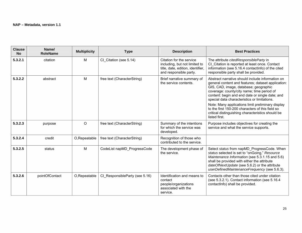
5.3.2 Service Identification
Type: SV_ServiceIdentification
Description: Service metadata describes the operation and address of an electronic geographic information delivery system.
Figure 4: Service identification
NAP – Metadata, version 1.1
25
Clause No
Name/ RoleName Multiplicity Type Description Best Practices
5.3.2.1 citation M CI_Citation (see 5.14) Citation for the service including, but not limited to title, date, edition, identifier, and responsible party.
The attribute citedResponsibleParty in CI_Citation is reported at least once. Contact information (see 5.16.4 contactInfo) of the cited responsible party shall be provided.
5.3.2.2 abstract M free text (CharacterString) Brief narrative summary of the service contents.
Abstract narrative should include information on general content and features; dataset application: GIS, CAD, image, database; geographic coverage: county/city name; time period of content: begin and end date or single date; and special data characteristics or limitations. Note: Many applications limit preliminary display to the first 150-200 characters of this field so critical distinguishing characteristics should be listed first.
5.3.2.3 purpose O free text (CharacterString) Summary of the intentions for which the service was developed.
Purpose includes objectives for creating the service and what the service supports.
5.3.2.4 credit O,Repeatable free text (CharacterString) Recognition of those who contributed to the service.
5.3.2.5 status M CodeList napMD_ProgressCode The development phase of the service.
Select status from napMD_ProgressCode. When status selected is set to “onGoing,” Resource Maintenance Information (see 5.3.1.15 and 5.6) shall be provided with either the attribute dateOfNextUpdate (see 5.6.2) or the attribute userDefinedMaintenanceFrequency (see 5.6.3).
5.3.2.6 pointOfContact O,Repeatable CI_ResponsibleParty (see 5.16) Identification and means to contact people/organizations associated with the service.
Contacts other than those cited under citation (see 5.3.2.1). Contact information (see 5.16.4 contactInfo) shall be provided.

NAP – Metadata, version 1.1
26
5.3.2.7 serviceType M GenericName (see B.8) The service type name from a service registry.
The registry namespace may be “OGC” and the service type name may be “Catalogue.”
5.3.2.8 serviceTypeVersion O,Repeatable free text (CharacterString) The version of the service type.
If the registry namespace is “OGC” and the service type name is “Catalogue” (as provided in 5.3.2.7), then the version can be “1.1”.
5.3.2.9 accessProperties O MD_StandardOrderProcess (see 5.11.4)
Information on the availability of the service which includes attributes from Standard Order Process including: fees, available date and time, ordering instructions, turnaround.
5.3.2.10 extent O,Repeatable EX_Extent (see 5.13) Describes the spatial (horizontal and/or vertical) and temporal coverage in the service.
5.3.2.11 couplingType M CodeList napSV_CouplingType Qualitative information on the tightness with which the service and the associated data are coupled.
Select couplingType from napSV_CouplingType.
5.3.2.12 coupledResource O,Repeatable SV_CoupledResource (see 5.3.8) Further description of the coupling between the service and the data when they are tightly coupled.
5.3.2.13 Resource Maintenance Information
O,Repeatable MD_MaintenanceInformation (see 5.6)
Describes the frequency, scope, and responsible party for updating the service.
5.3.2.14 Graphic Overview O,Repeatable MD_BrowseGraphic (see 5.3.5) The name of, description of, and file type of an
NAP – Metadata, version 1.1
27
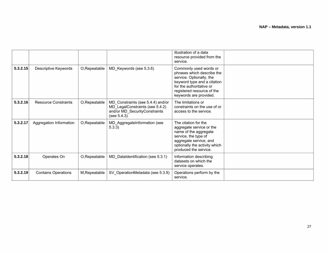
illustration of a data resource provided from the service.
5.3.2.15 Descriptive Keywords O,Repeatable MD_Keywords (see 5.3.6) Commonly used words or phrases which describe the service. Optionally, the keyword type and a citation for the authoritative or registered resource of the keywords are provided.
5.3.2.16 Resource Constraints O,Repeatable MD_Constraints (see 5.4.4) and/or MD_LegalConstraints (see 5.4.2) and/or MD_SecurityConstraints (see 5.4.3)
The limitations or constraints on the use of or access to the service.
5.3.2.17 Aggregation Information O,Repeatable MD_AggregateInformation (see 5.3.3)
The citation for the aggregate service or the name of the aggregate service, the type of aggregate service, and optionally the activity which produced the service.
5.3.2.18 Operates On O,Repeatable MD_DataIdentification (see 5.3.1) Information describing datasets on which the service operates.
5.3.2.19 Contains Operations M,Repeatable SV_OperationMetadata (see 5.3.9) Operations perform by the service.

NAP – Metadata, version 1.1
28
5.3.3 Spatial Resolution
Type: MD_Resolution
Description: The level of detail in a dataset expressed as equivalent scale or ground distance.
BP: One and only one of the following must be entered: equivelentScale, or distance as appropriate.
Figure 5: Resolution

NAP – Metadata, version 1.1
29
Clause No
Name/ RoleName Multiplicity Type Description Best Practices
5.3.3.1 equivalentScale M MD_RepresentativeFraction (see 5.3.4)
Detail expressed as the numerical scale of a comparable hardcopy map or chart.
5.3.3.2 distance M Distance (see B.7) Ground sample distance.

NAP – Metadata, version 1.1
30
5.3.4 Representative Fraction
Type: MD_RepresentativeFraction
Description: The scale of a map or other cartographic object expressed as a fraction or ratio which relates unit distance on the map or other cartographic object to distance, measured in the same units, on the ground.
Figure 6: Representative fraction

NAP – Metadata, version 1.1
31
Clause No
Name/ RoleName Multiplicity Type Description Best Practices
5.3.4.1 denominator M Integer (see B.13) The number below the line in a proper fraction that the numerator is equal to 1.
Value is greater than 0.

NAP – Metadata, version 1.1
32
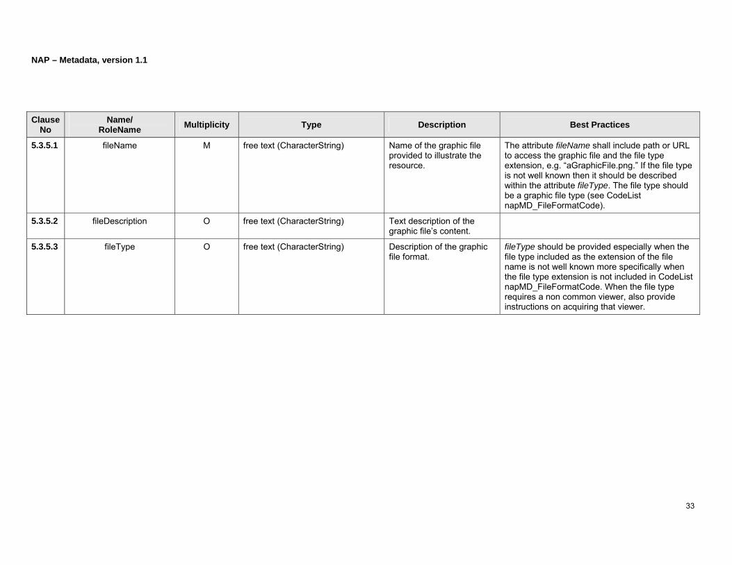
5.3.5 Browse Graphic
Type: MD_BrowseGraphic
Description: The name, description, and file type of an illustration of the resource.
Figure 7: Browse graphic
NAP – Metadata, version 1.1
33
Clause No
Name/ RoleName Multiplicity Type Description Best Practices
5.3.5.1 fileName M free text (CharacterString) Name of the graphic file provided to illustrate the resource.
The attribute fileName shall include path or URL to access the graphic file and the file type extension, e.g. “aGraphicFile.png.” If the file type is not well known then it should be described within the attribute fileType. The file type should be a graphic file type (see CodeList napMD_FileFormatCode).
5.3.5.2 fileDescription O free text (CharacterString) Text description of the graphic file’s content.
5.3.5.3 fileType O free text (CharacterString) Description of the graphic file format.
fileType should be provided especially when the file type included as the extension of the file name is not well known more specifically when the file type extension is not included in CodeList napMD_FileFormatCode. When the file type requires a non common viewer, also provide instructions on acquiring that viewer.

NAP – Metadata, version 1.1
34
5.3.6 Keywords
Type: MD_Keywords
Description: Commonly used words or phrases which describe the resource. Optionally, the keyword type and a citation for the authoritative or registered resource of the keywords are also provided.
BP: It is highly recommended that keywords from the authoritative source be used instead of using user defined keywords. Communities should make available on the Web specific thesauruses of keywords developed for use with this profile.
Figure 8: Keywords

NAP – Metadata, version 1.1
35
Clause No
Name/ RoleName Multiplicity Type Description Best Practices
5.3.6.1 keyword M,Repeatable free text (CharacterString) Commonly used words or phrases which describe the resource.
5.3.6.2 type O CodeList napMD_KeywordTypeCode
Terms or type used to group keywords: discipline, place, stratum, temporal, or theme.
Select type from napMD_KeywordTypeCode.
5.3.6.3 thesaurusName O CI_Citation (see 5.14) The name of a registered authoritative keyword resource.
Strongly recommend to provide contact information (see 5.16.4 contactInfo).
NAP – Metadata, version 1.1
36
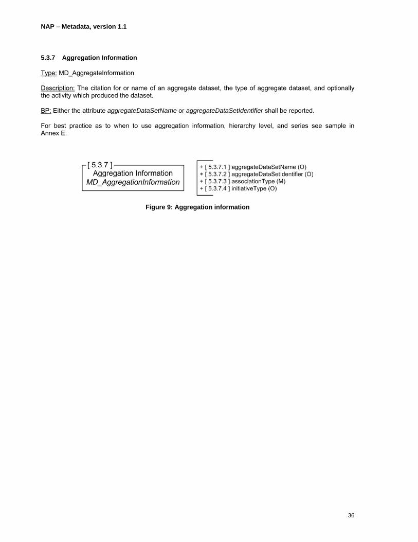
5.3.7 Aggregation Information
Type: MD_AggregateInformation
Description: The citation for or name of an aggregate dataset, the type of aggregate dataset, and optionally the activity which produced the dataset.
BP: Either the attribute aggregateDataSetName or aggregateDataSetIdentifier shall be reported.
For best practice as to when to use aggregation information, hierarchy level, and series see sample in Annex E.
Figure 9: Aggregation information

NAP – Metadata, version 1.1
37
Clause No
Name/ RoleName Multiplicity Type Description Best Practices
5.3.7.1 aggregateDataSetName O CI_Citation (see 5.14) Citation information for the aggregate resource or initiative.
Strongly recommend to provide contact information (see 5.16.4) under cited responsible party (see 5.14.7).
5.3.7.2 aggregateDataSetIdentifier O MD_Identifier (see 5.22) Identification of the aggregate dataset.
5.3.7.3 associationType M CodeList napDS_AssociationTypeCode
Association type of the aggregate dataset.
Select associationType from napDS_AssociationTypeCode. In order to allow navigation from aggregate datasets to datasets that contribute parts to the aggregate dataset, the association type code isComposedOf has been introduced. However, this approach is not encouraged since every time a dataset is derived from the aggregate dataset, it implies an update of the aggregate dataset metadata mentioning that the aggregate dataset is composed of this new derived dataset.
5.3.7.4 initiativeType O CodeList napDS_InitiativeTypeCode
Type of initiative for which the dataset was developed.
Select initiativeType from napDS_InitiativeTypeCode.
NAP – Metadata, version 1.1
38
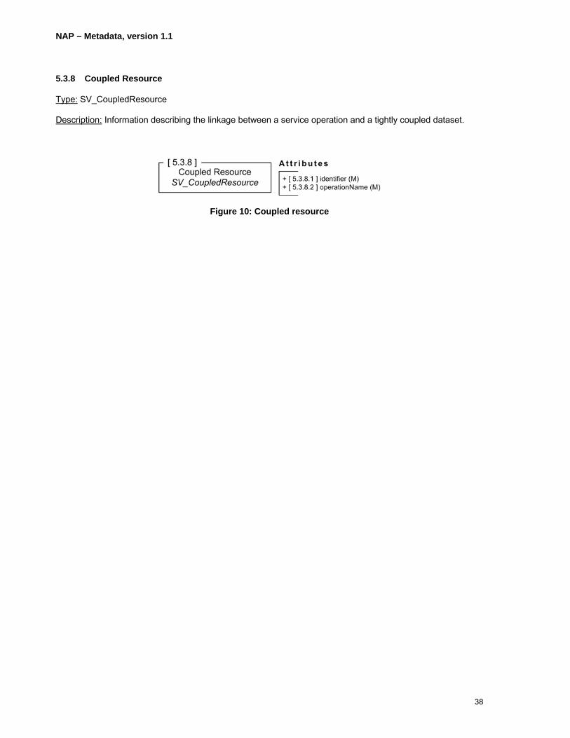
5.3.8 Coupled Resource
Type: SV_CoupledResource
Description: Information describing the linkage between a service operation and a tightly coupled dataset.
Figure 10: Coupled resource

NAP – Metadata, version 1.1
39
Clause No
Name/ RoleName Multiplicity Type Description Best Practices
5.3.8.1 identifier M free text (CharacterString) The dataset name or identifier of the associated dataset.
5.3.8.2 operationName M free text (CharacterString) Designation of the operation.
NAP – Metadata, version 1.1
40
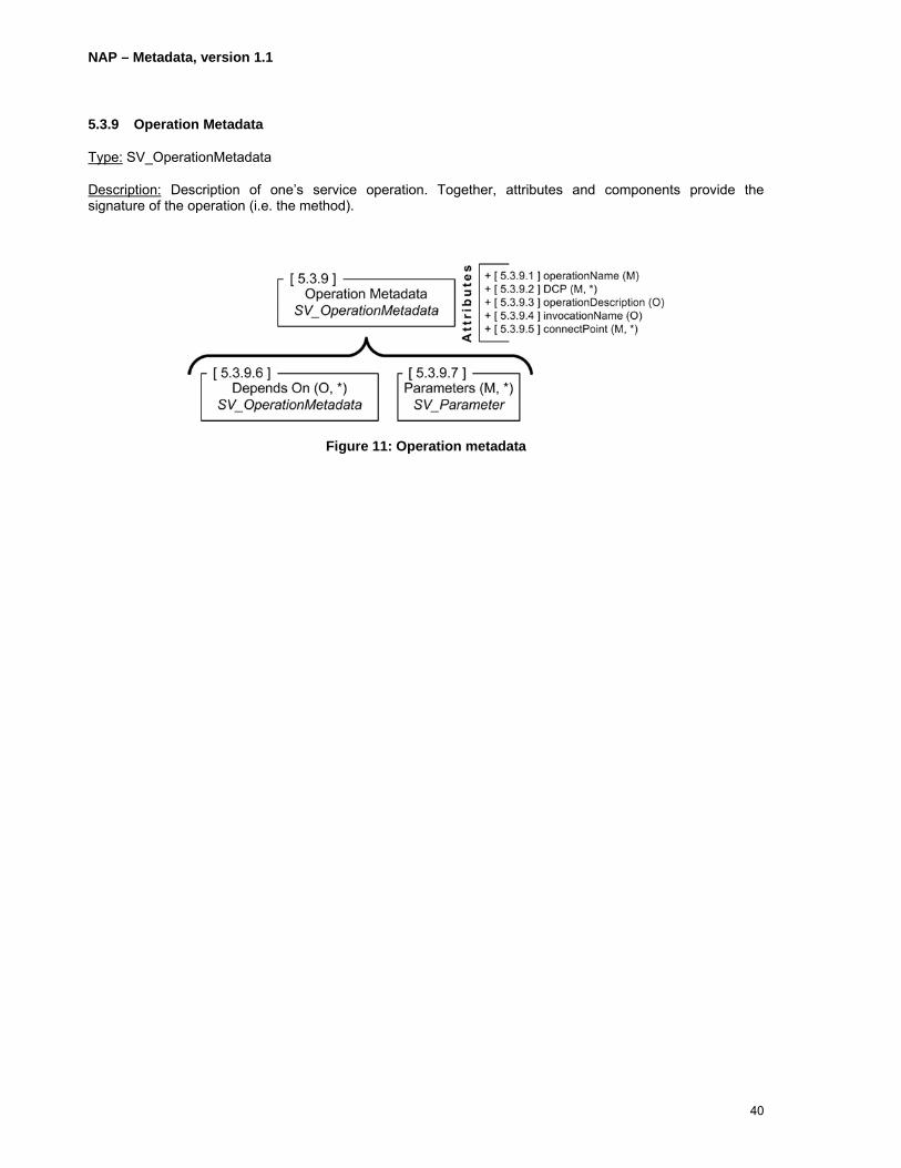
5.3.9 Operation Metadata
Type: SV_OperationMetadata
Description: Description of one’s service operation. Together, attributes and components provide the signature of the operation (i.e. the method).
Figure 11: Operation metadata
NAP – Metadata, version 1.1
41
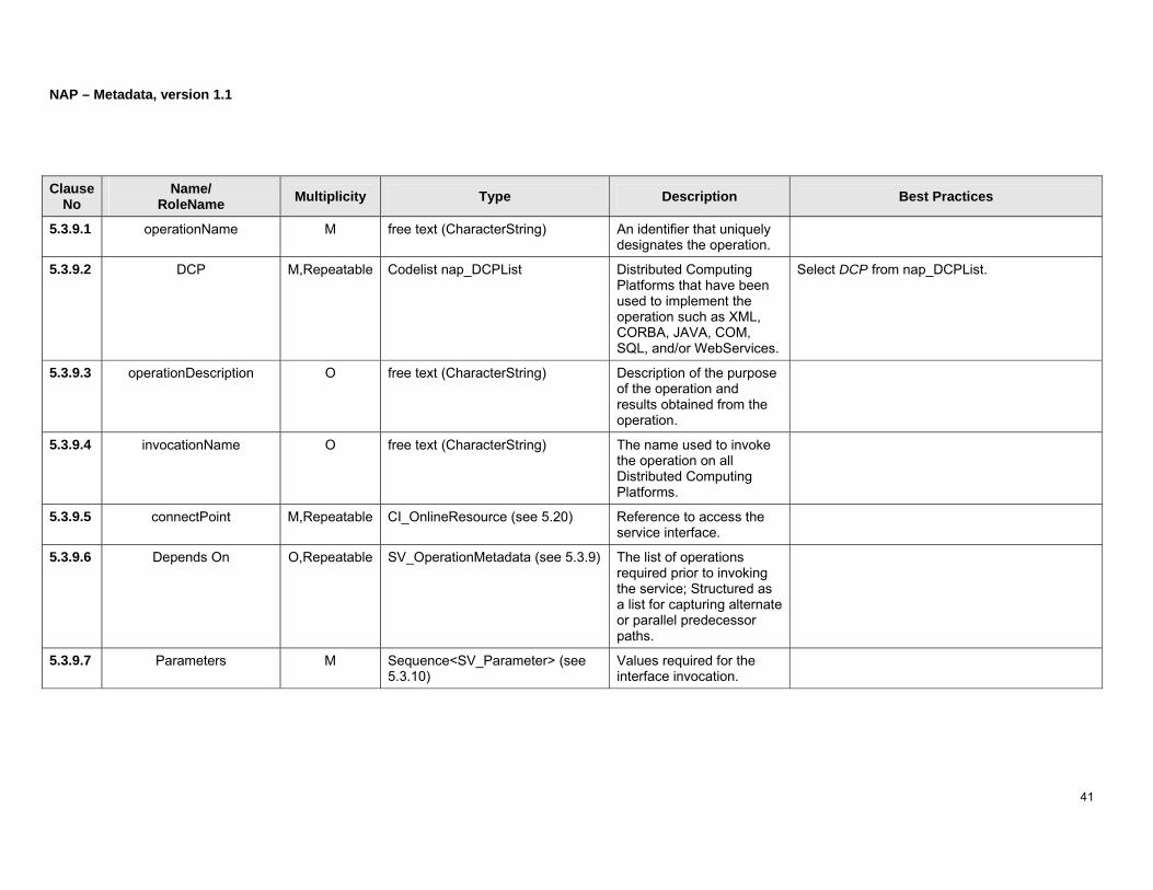
Clause No
Name/ RoleName Multiplicity Type Description Best Practices
5.3.9.1 operationName M free text (CharacterString) An identifier that uniquely designates the operation.
5.3.9.2 DCP M,Repeatable Codelist nap_DCPList Distributed Computing Platforms that have been used to implement the operation such as XML, CORBA, JAVA, COM, SQL, and/or WebServices.
Select DCP from nap_DCPList.
5.3.9.3 operationDescription O free text (CharacterString) Description of the purpose of the operation and results obtained from the operation.
5.3.9.4 invocationName O free text (CharacterString) The name used to invoke the operation on all Distributed Computing Platforms.
5.3.9.5 connectPoint M,Repeatable CI_OnlineResource (see 5.20) Reference to access the service interface.
5.3.9.6 Depends On O,Repeatable SV_OperationMetadata (see 5.3.9) The list of operations required prior to invoking the service; Structured as a list for capturing alternate or parallel predecessor paths.
5.3.9.7 Parameters M Sequence<SV_Parameter> (see 5.3.10)
Values required for the interface invocation.
NAP – Metadata, version 1.1
42
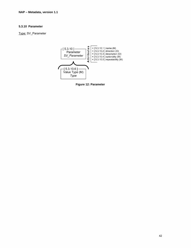
5.3.10 Parameter
Type: SV_Parameter
Figure 12: Parameter

NAP – Metadata, version 1.1
43
Clause No
Name/ RoleName Multiplicity Type Description Best Practices
5.3.10.1 name M MemberName (see B.15) The name that the service uses for the parameter.
5.3.10.2 direction O Enumeration SV_ParameterDirection
Indication if the parameter serves as input, output, or both.
5.3.10.3 description O free text (CharacterString) Explanation of the purpose and function of the parameter.
5.3.10.4 optionality M free text (CharacterString) Indicates the necessity of the parameter.
The default value is “Mandatory.”
5.3.10.5 repeatability M Boolean (see B.2) Indication if one or more values for the parameter may be provided.
“0” means not repeatable and “1” means repeatable.
5.3.10.6 Value Type M Type (see B.23) The class used for the value type.

NAP – Metadata, version 1.1
44
5.4 Constraint (O,Repeatable)
Constraints are reported through metadata constraint information and/or legal constraints and/or security constraints.
Figure 13: Constraint information

NAP – Metadata, version 1.1
45
Clause No
Name/ RoleName Multiplicity Type Description Best Practices
5.4.1 Constraint Information MD_Constraints The limitations, restrictions, or statements on the resource fitness for use.
5.4.1.1 useLimitation O,Repeatable free text (CharacterString) Statement on the fitness of use or limitations on the use of the resource or metadata.
The attribute useLimitation is mandatory unless MD_LegalConstraints or MD_SecurityConstraints is used.
5.4.2 Legal Constraints MD_LegalConstraints The legal restrictions or prerequisites to using the resource or accessing the metadata.
Legal constraints should be repeated for multiple legal access constraints such as those associated with privacy, sensitivity, and statutory.
5.4.2.1 useLimitation O,Repeatable free text (CharacterString) Statement on the fitness of use or limitations on the use of the resource or metadata.
5.4.2.2 accessConstraints O,Repeatable CodeList napMD_RestrictionCode Limitations on access to the resource or metadata to protect privacy, intellectual property, or any special limitations.
Select accessConstraints from napMD_RestrictionCode.
5.4.2.3 useConstraints O,Repeatable CodeList napMD_RestrictionCode Restrictions or limitations or warnings to protect privacy, intellectual property, or other special restrictions on the resource or the metadata.
Select useConstraints from napMD_RestrictionCode.
5.4.2.4 otherConstraints C,Repeatable free text (CharacterString) Other restrictions or legal prerequisites for accessing the resource or metadata.
Shall be provided if accessConstraints or useConstraints is set to “otherRestrictions.” For an example: “Data only to be used for the
NAP – Metadata, version 1.1
46
purposes for which they were collected.”
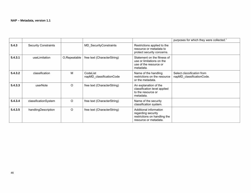
5.4.3 Security Constraints MD_SecurityConstraints Restrictions applied to the resource or metadata to protect security concerns.
5.4.3.1 useLimitation O,Repeatable free text (CharacterString) Statement on the fitness of use or limitations on the use of the resource or metadata.
5.4.3.2 classification M CodeList napMD_classificationCode
Name of the handling restrictions on the resource or the metadata.
Select classification from napMD_classificationCode.
5.4.3.3 userNote O free text (CharacterString) An explanation of the classification level applied to the resource or metadata.
5.4.3.4 classificationSystem O free text (CharacterString) Name of the security classification system.
5.4.3.5 handlingDescription O free text (CharacterString) Additional information regarding security restrictions on handling the resource or metadata.

NAP – Metadata, version 1.1
47
(Page intentionally left blank)
NAP – Metadata, version 1.1
48
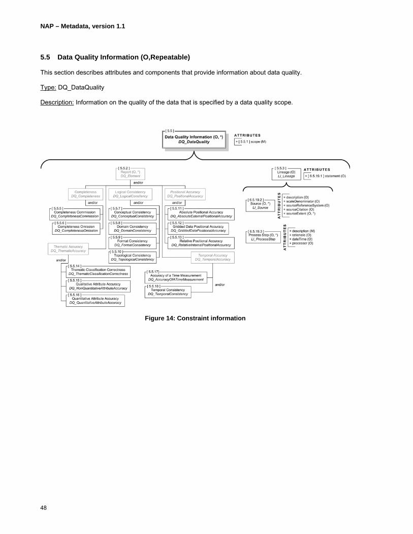
5.5 Data Quality Information (O,Repeatable)
This section describes attributes and components that provide information about data quality.
Type: DQ_DataQuality
Description: Information on the quality of the data that is specified by a data quality scope.
Figure 14: Constraint information
NAP – Metadata, version 1.1
49
Clause No
Name/ RoleName Multiplicity Type Description Best Practices
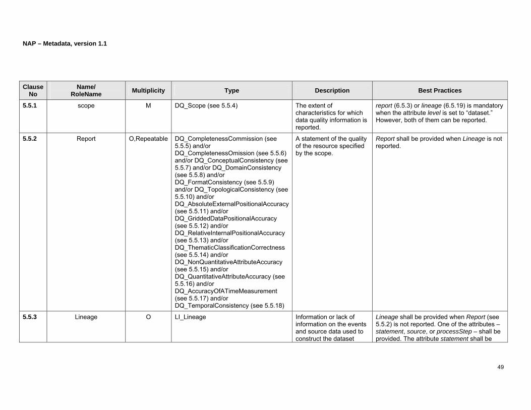
5.5.1 scope M DQ_Scope (see 5.5.4) The extent of characteristics for which data quality information is reported.
report (6.5.3) or lineage (6.5.19) is mandatory when the attribute level is set to “dataset.” However, both of them can be reported.
5.5.2 Report O,Repeatable DQ_CompletenessCommission (see 5.5.5) and/or DQ_CompletenessOmission (see 5.5.6) and/or DQ_ConceptualConsistency (see 5.5.7) and/or DQ_DomainConsistency (see 5.5.8) and/or DQ_FormatConsistency (see 5.5.9) and/or DQ_TopologicalConsistency (see 5.5.10) and/or DQ_AbsoluteExternalPositionalAccuracy (see 5.5.11) and/or DQ_GriddedDataPositionalAccuracy (see 5.5.12) and/or DQ_RelativeInternalPositionalAccuracy (see 5.5.13) and/or DQ_ThematicClassificationCorrectness (see 5.5.14) and/or DQ_NonQuantitativeAttributeAccuracy (see 5.5.15) and/or DQ_QuantitativeAttributeAccuracy (see 5.5.16) and/or DQ_AccuracyOfATimeMeasurement (see 5.5.17) and/or DQ_TemporalConsistency (see 5.5.18)
A statement of the quality of the resource specified by the scope.
Report shall be provided when Lineage is not reported.
5.5.3 Lineage O LI_Lineage Information or lack of information on the events and source data used to construct the dataset
Lineage shall be provided when Report (see 5.5.2) is not reported. One of the attributes – statement, source, or processStep – shall be provided. The attribute statement shall be

NAP – Metadata, version 1.1
50
within the specified Scope.
provided when (1) the attributes source and processStep are not provided and (2) the attribute level of the scope of DQ_Quality is set to “dataset” or “series.”
5.5.3.1 statement O free text (CharacterString) General explanation of the data producer’s knowledge of the dataset lineage.
5.5.3.2 source O,Repeatable LI_Source (see 5.5.22) Information on the sources used in the development of the dataset.
Source is provided when statement or processStep is not reported.
5.5.3.3 processStep O,Repeatable LI_ProcessStep (see 5.5.23) The events in the development of the dataset.

NAP – Metadata, version 1.1
51
(Page intentionally left blank)
NAP – Metadata, version 1.1
52
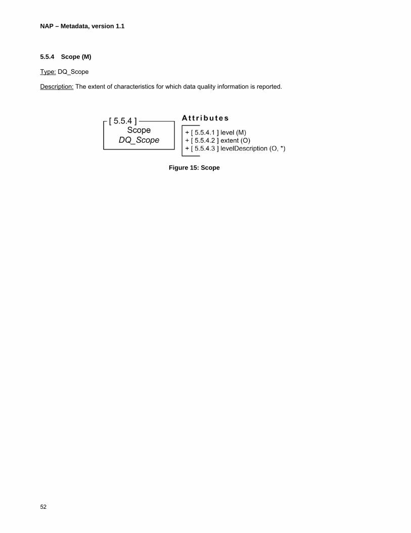
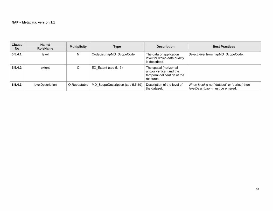
5.5.4 Scope (M)
Type: DQ_Scope
Description: The extent of characteristics for which data quality information is reported.
Figure 15: Scope
NAP – Metadata, version 1.1
53
Clause No
Name/ RoleName Multiplicity Type Description Best Practices
5.5.4.1 level M CodeList napMD_ScopeCode The data or application level for which data quality is described.
Select level from napMD_ScopeCode.
5.5.4.2 extent O EX_Extent (see 5.13) The spatial (horizontal and/or vertical) and the temporal delineation of the resource.
5.5.4.3 levelDescription O,Repeatable MD_ScopeDescription (see 5.5.19) Description of the level of the dataset.
When level is not “dataset” or “series” then levelDescription must be entered.

NAP – Metadata, version 1.1
54
5.5.5 Completeness Commission (O,Repeatable)
Type: DQ_CompletenessCommission
Description: Notification of excess data present in the dataset beyond the extent defined in Scope.
Figure 16: Completeness commission

NAP – Metadata, version 1.1
55
Clause No
Name/ RoleName Multiplicity Type Description Best Practices
5.5.5.1 nameOfMeasure O,Repeatable free text (CharacterString) Name of the test applied to the data to assure data quality.
5.5.5.2 measureIdentification O MD_Identifier (see 5.22) Code which identifies a registered standard data quality procedure.
5.5.5.3 measureDescription O free text (CharacterString) Description of the measure applied to the dataset to assure quality.
5.5.5.4 evaluationMethodType O CodeList napDQ_EvaluationMethodTypeCode
Method type used to evaluate data quality in the dataset.
Select evaluationMethodType from napDQ_EvaluationMethodTypeCode.
5.5.5.5 evaluationMethodDescription O free text (CharacterString) Description of the evaluation method applied to the dataset.
5.5.5.6 evaluationProcedure O CI_Citation (see 5.14) Citation for the evaluation procedure.
Strongly recommend to provide contact information (see 5.16.4) under cited responsible party (see 5.14.7).
5.5.5.7 dateTime O,Repeatable DateTime (see B.5) Date and time at which the test was completed.
DateTime cannot support the description of duration; only single time is allowed.
5.5.5.8 result M,2 DQ_QuantitativeResult (see 5.5.20) and/or DQ_ConformanceResult (see 5.5.21)
Value(s) obtained from data quality test or outcome from applying data quality measure against a specified/acceptable quality conformance level.
NAP – Metadata, version 1.1
56
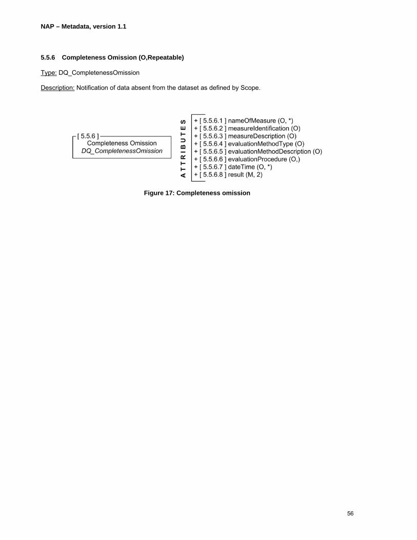
5.5.6 Completeness Omission (O,Repeatable)
Type: DQ_CompletenessOmission
Description: Notification of data absent from the dataset as defined by Scope.
Figure 17: Completeness omission

NAP – Metadata, version 1.1
57
Clause No
Name/ RoleName Multiplicity Type Description Best Practices
5.5.6.1 nameOfMeasure O,Repeatable free text (CharacterString) Name of the test applied to the data to assure data quality.
5.5.6.2 measureIdentification O MD_Identifier (see 5.22) Code which identifies a registered standard data quality procedure.
5.5.6.3 measureDescription O free text (CharacterString) Description of the measure applied to the dataset to assure quality.
5.5.6.4 evaluationMethodType O CodeList napDQ_EvaluationMethodTypeCode
Method type used to evaluate data quality in the dataset.
Select evaluationMethodType from napDQ_EvaluationMethodTypeCode.
5.5.6.5 evaluationMethodDescription O free text (CharacterString) Description of the evaluation method applied to the dataset.
5.5.6.6 evaluationProcedure O CI_Citation (see 5.14) Citation for the evaluation procedure.
Strongly recommend to provide contact information (see 5.16.4) under cited responsible party (see 5.14.7).
5.5.6.7 dateTime O,Repeatable DateTime (see B.5) Date and time at which the test was completed.
DateTime cannot support the description of duration; only single time is allowed.
5.5.6.8 result M,2 DQ_QuantitativeResult (see 5.5.20) and/or DQ_ConformanceResult (see 5.5.21)
Value(s) obtained from data quality test or outcome from applying data quality measure against a specified/acceptable quality conformance level.

NAP – Metadata, version 1.1
58
5.5.7 Conceptual Consistency (O,Repeatable)
Type: DQ_ConceptualConsistency
Description: The level to which the dataset adheres to the conceptual schema. For example, conceptual consistency might describe to which level the resource complies with the data structure and attributing of the conceptual schemas – i.e. feature types, features attributes, relationships between features, etc.
Figure 18: Conceptual consistency

NAP – Metadata, version 1.1
59
Clause No
Name/ RoleName Multiplicity Type Description Best Practices
5.5.7.1 nameOfMeasure O,Repeatable free text (CharacterString) Name of the test applied to the data to assure data quality.
5.5.7.2 measureIdentification O MD_Identifier (see 5.22) Code which identifies a registered standard data quality procedure.
5.5.7.3 measureDescription O free text (CharacterString) Description of the measure applied to the dataset to assure quality.
5.5.7.4 evaluationMethodType O CodeList napDQ_EvaluationMethodTypeCode
Method type used to evaluate data quality in the dataset.
Select evaluationMethodType from napDQ_EvaluationMethodTypeCode.
5.5.7.5 evaluationMethodDescription O free text (CharacterString) Description of the evaluation method applied to the dataset.
5.5.7.6 evaluationProcedure O CI_Citation (see 5.14) Citation for the evaluation procedure.
Strongly recommend to provide contact information (see 5.16.4) under cited responsible party (see 5.14.7).
5.5.7.7 dateTime O,Repeatable DateTime (see B.5) Date and time at which the test was completed.
DateTime cannot support the description of duration; only single time is allowed.
5.5.7.8 result M,2 DQ_QuantitativeResult (see 5.5.20) and/or DQ_ConformanceResult (see 5.5.21)
Value(s) obtained from data quality test or outcome from applying data quality measure against a specified/acceptable quality conformance level.

NAP – Metadata, version 1.1
60
5.5.8 Domain Consistency (O,Repeatable)
Type: DQ_DomainConsistency
Description: The adherence of resource attribute values to conceptual schema specified values.
Figure 19: Domain consistency

NAP – Metadata, version 1.1
61
Clause No
Name/ RoleName Multiplicity Type Description Best Practices
5.5.8.1 nameOfMeasure O,Repeatable free text (CharacterString) Name of the test applied to the data to assure data quality.
5.5.8.2 measureIdentification O MD_Identifier (see 5.22) Code which identifies a registered standard data quality procedure.
5.5.8.3 measureDescription O free text (CharacterString) Description of the measure applied to the dataset to assure quality.
5.5.8.4 evaluationMethodType O CodeList napDQ_EvaluationMethodTypeCode
Method type used to evaluate data quality in the dataset.
Select evaluationMethodType from napDQ_EvaluationMethodTypeCode.
5.5.8.5 evaluationMethodDescription O free text (CharacterString) Description of the evaluation method applied to the dataset.
5.5.8.6 evaluationProcedure O CI_Citation (see 5.15) Citation for the evaluation procedure.
Strongly recommend to provide contact information (see 5.16.4) under cited responsible party (see 5.14.7).
5.5.8.7 dateTime O,Repeatable DateTime (see B.5) Date and time at which the test was completed.
DateTime cannot support the description of duration; only single time is allowed.
5.5.8.8 result M,2 DQ_QuantitativeResult (see 5.5.20) and/or DQ_ConformanceResult (see 5.5.21)
Value(s) obtained from data quality test or outcome from applying data quality measure against a specified/acceptable quality conformance level.

NAP – Metadata, version 1.1
62
5.5.9 Format Consistency (O,Repeatable)
Type: DQ_ FormatConsistency
Description: The level of data storage agreement with the dataset physical structure as described by the attribute scope (see 5.5.1).
Figure 20: Format consistency

NAP – Metadata, version 1.1
63
Clause No
Name/ RoleName Multiplicity Type Description Best Practices
5.5.9.1 nameOfMeasure O,Repeatable free text (CharacterString) Name of the test applied to the data to assure data quality.
5.5.9.2 measureIdentification O MD_Identifier (see 5.22) Code which identifies a registered standard data quality procedure.
5.5.9.3 measureDescription O free text (CharacterString) Description of the measure applied to the dataset to assure quality.
5.5.9.4 evaluationMethodType O CodeList napDQ_EvaluationMethodTypeCode
Method type used to evaluate data quality in the dataset.
Select evaluationMethodType from napDQ_EvaluationMethodTypeCode.
5.5.9.5 evaluationMethodDescription O free text (CharacterString) Description of the evaluation method applied to the dataset.
5.5.9.6 evaluationProcedure O CI_Citation (see 5.14) Citation for the evaluation procedure.
Strongly recommend to provide contact information (see 5.16.4) under cited responsible party (see 5.14.7).
5.5.9.7 dateTime O,Repeatable DateTime (see B.5) Date and time at which the test was completed.
DateTime cannot support the description of duration; only single time is allowed.
5.5.9.8 result M,2 DQ_QuantitativeResult (see 5.5.20) and/or DQ_ConformanceResult (see 5.5.21)
Value(s) obtained from data quality test or outcome from applying data quality measure against a specified/acceptable quality conformance level.

NAP – Metadata, version 1.1
64
5.5.10 Topological Consistency (O,Repeatable)
Type: DQ_TopologicalConsistency
Description: The testing for topological correctness of encoded characteristics in the dataset as delimited by Scope.
Figure 21: Topological consistency

NAP – Metadata, version 1.1
65
Clause No
Name/ RoleName Multiplicity Type Description Best Practices
5.5.10.1 nameOfMeasure O,Repeatable free text (CharacterString) Name of the test applied to the data to assure data quality.
5.5.10.2 measureIdentification O MD_Identifier (see 5.22) Code which identifies a registered standard data quality procedure.
5.5.10.3 measureDescription O free text (CharacterString) Description of the measure applied to the dataset to assure quality.
5.5.10.4 evaluationMethodType O CodeList napDQ_EvaluationMethodTypeCode
Method type used to evaluate data quality in the dataset.
Select evaluationMethodType from napDQ_EvaluationMethodTypeCode.
5.5.10.5 evaluationMethodDescription O free text (CharacterString) Description of the evaluation method applied to the dataset.
5.5.10.6 evaluationProcedure O CI_Citation (see 5.14) Citation for the evaluation procedure.
Strongly recommend to provide contact information (see 5.16.4) under cited responsible party (see 5.14.7).
5.5.10.7 dateTime O,Repeatable DateTime (see B.5) Date and time at which the test was completed.
DateTime cannot support the description of duration; only single time is allowed.
5.5.10.8 result M,2 DQ_QuantitativeResult (see 5.5.20) and/or DQ_ConformanceResult (see 5.5.21)
Value(s) obtained from data quality test or outcome from applying data quality measure against a specified/acceptable quality conformance level.
NAP – Metadata, version 1.1
66
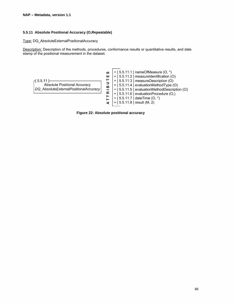
5.5.11 Absolute Positional Accuracy (O,Repeatable)
Type: DQ_AbsoluteExternalPositionalAccuracy
Description: Description of the methods, procedures, conformance results or quantitative results, and date stamp of the positional measurement in the dataset.
Figure 22: Absolute positional accuracy

NAP – Metadata, version 1.1
67
Clause No
Name/ RoleName Multiplicity Type Description Best Practices
5.5.11.1 nameOfMeasure O,Repeatable free text (CharacterString) Name of the test applied to the data to assure data quality.
5.5.11.2 measureIdentification O MD_Identifier (see 5.22) Code which identifies a registered standard data quality procedure.
5.5.11.3 measureDescription O free text (CharacterString) Description of the measure applied to the dataset to assure quality.
5.5.11.4 evaluationMethodType O CodeList napDQ_EvaluationMethodTypeCode
Method type used to evaluate data quality in the dataset.
Select evaluationMethodType from napDQ_EvaluationMethodTypeCode.
5.5.11.5 evaluationMethodDescription O free text (CharacterString) Description of the evaluation method applied to the dataset.
5.5.11.6 evaluationProcedure O CI_Citation (see 5.14) Citation for the evaluation procedure.
Strongly recommend to provide contact information (see 5.16.4) under cited responsible party (see 5.14.7).
5.5.11.7 dateTime O,Repeatable DateTime (see B.5) Date and time at which the test was completed.
DateTime cannot support the description of duration; only single time is allowed.
5.5.11.8 result M,2 DQ_QuantitativeResult (see 5.5.20) and/or DQ_ConformanceResult (see 5.5.21)
Value(s) obtained from data quality test or outcome from applying data quality measure against a specified/acceptable quality conformance level.
NAP – Metadata, version 1.1
68
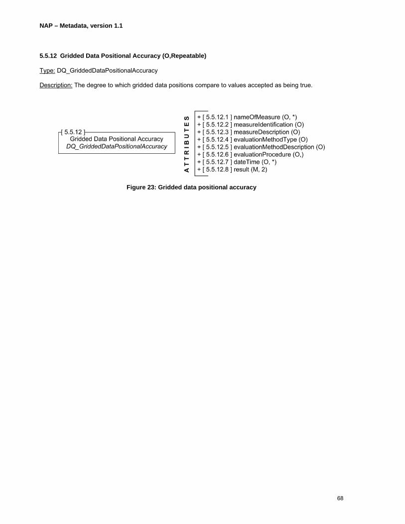
5.5.12 Gridded Data Positional Accuracy (O,Repeatable)
Type: DQ_GriddedDataPositionalAccuracy
Description: The degree to which gridded data positions compare to values accepted as being true.
Figure 23: Gridded data positional accuracy
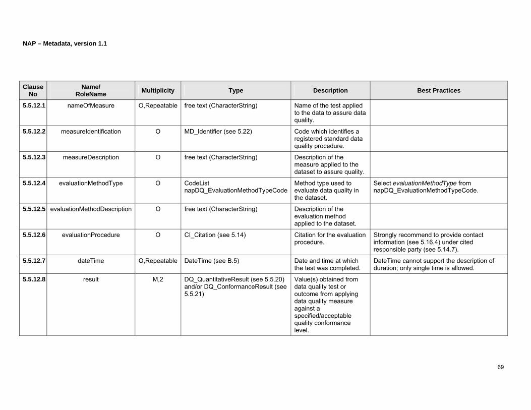
NAP – Metadata, version 1.1
69
Clause No
Name/ RoleName Multiplicity Type Description Best Practices
5.5.12.1 nameOfMeasure O,Repeatable free text (CharacterString) Name of the test applied to the data to assure data quality.
5.5.12.2 measureIdentification O MD_Identifier (see 5.22) Code which identifies a registered standard data quality procedure.
5.5.12.3 measureDescription O free text (CharacterString) Description of the measure applied to the dataset to assure quality.
5.5.12.4 evaluationMethodType O CodeList napDQ_EvaluationMethodTypeCode
Method type used to evaluate data quality in the dataset.
Select evaluationMethodType from napDQ_EvaluationMethodTypeCode.
5.5.12.5 evaluationMethodDescription O free text (CharacterString) Description of the evaluation method applied to the dataset.
5.5.12.6 evaluationProcedure O CI_Citation (see 5.14) Citation for the evaluation procedure.
Strongly recommend to provide contact information (see 5.16.4) under cited responsible party (see 5.14.7).
5.5.12.7 dateTime O,Repeatable DateTime (see B.5) Date and time at which the test was completed.
DateTime cannot support the description of duration; only single time is allowed.
5.5.12.8 result M,2 DQ_QuantitativeResult (see 5.5.20) and/or DQ_ConformanceResult (see 5.5.21)
Value(s) obtained from data quality test or outcome from applying data quality measure against a specified/acceptable quality conformance level.
NAP – Metadata, version 1.1
70
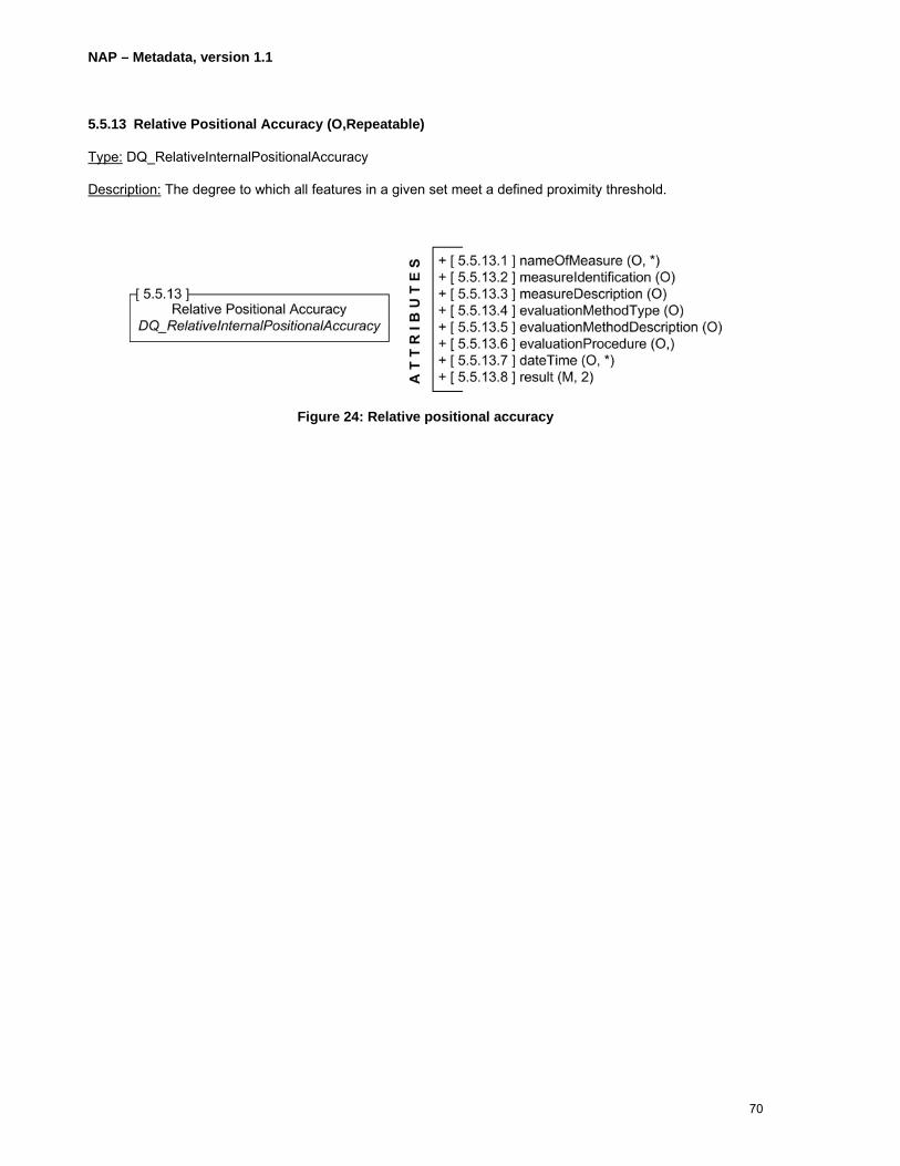
5.5.13 Relative Positional Accuracy (O,Repeatable)
Type: DQ_RelativeInternalPositionalAccuracy
Description: The degree to which all features in a given set meet a defined proximity threshold.
Figure 24: Relative positional accuracy

NAP – Metadata, version 1.1
71
Clause No
Name/ RoleName Multiplicity Type Description Best Practices
5.5.13.1 nameOfMeasure O,Repeatable free text (CharacterString) Name of the test applied to the data to assure data quality.
5.5.13.2 measureIdentification O MD_Identifier (see 5.22) Code which identifies a registered standard data quality procedure.
5.5.13.3 measureDescription O free text (CharacterString) Description of the measure applied to the dataset to assure quality.
5.5.13.4 evaluationMethodType O CodeList napDQ_EvaluationMethodTypeCode
Method type used to evaluate data quality in the dataset.
Select evaluationMethodType from napDQ_EvaluationMethodTypeCode.
5.5.13.5 evaluationMethodDescription O free text (CharacterString) Description of the evaluation method applied to the dataset.
5.5.13.6 evaluationProcedure O CI_Citation (see 5.14) Citation for the evaluation procedure.
Strongly recommend to provide contact information (see 5.16.4) under cited responsible party (see 5.14.7).
5.5.13.7 dateTime O,Repeatable DateTime (see B.5) Date and time at which the test was completed.
DateTime cannot support the description of duration; only single time is allowed.
5.5.13.8 result M,2 DQ_QuantitativeResult (see 5.5.20) and/or DQ_ConformanceResult (see 5.5.21)
Value(s) obtained from data quality test or outcome from applying data quality measure against a specified/acceptable quality conformance level.

NAP – Metadata, version 1.1
72
5.5.14 Thematic Classification Correctness (O,Repeatable)
Type: DQ_ThematicClassificationCorrectness
Description: Comparison of classes or attributes assigned to features or feature attributes respectively with respect to a recognized repository of features that pertain in a particular context.
Figure 25: Thematic classification correctness

NAP – Metadata, version 1.1
73
Clause No
Name/ RoleName Multiplicity Type Description Best Practices
5.5.14.1 nameOfMeasure O,Repeatable free text (CharacterString) Name of the test applied to the data to assure data quality.
5.5.14.2 measureIdentification O MD_Identifier (see 5.22) Code which identifies a registered standard data quality procedure.
5.5.14.3 measureDescription O free text (CharacterString) Description of the measure applied to the dataset to assure quality.
5.5.14.4 evaluationMethodType O CodeList napDQ_EvaluationMethodTypeCode
Method type used to evaluate data quality in the dataset.
Select evaluationMethodType from napDQ_EvaluationMethodTypeCode.
5.5.14.5 evaluationMethodDescription O free text (CharacterString) Description of the evaluation method applied to the dataset.
5.5.14.6 evaluationProcedure O CI_Citation (see 5.14) Citation for the evaluation procedure.
Strongly recommend to provide contact information (see 5.16.4) under cited responsible party (see 5.14.7).
5.5.14.7 dateTime O,Repeatable DateTime (see B.5) Date and time at which the test was completed.
DateTime cannot support the description of duration; only single time is allowed.
5.5.14.8 result M,2 DQ_QuantitativeResult (see 5.5.20) and/or DQ_ConformanceResult (see 5.5.21)
Value(s) obtained from data quality test or outcome from applying data quality measure against a specified/acceptable quality conformance level.

NAP – Metadata, version 1.1
74
5.5.15 Qualitative Attribute Accuracy (O,Repeatable)
Type: DQ_NonQuantitativeAttributeAccuracy
Description: Degree to which qualitative attributes reflect the stated requirements.
Figure 26: Qualitative attribute accuracy

NAP – Metadata, version 1.1
75
Clause No
Name/ RoleName Multiplicity Type Description Best Practices
5.5.15.1 nameOfMeasure O,Repeatable free text (CharacterString) Name of the test applied to the data to assure data quality.
5.5.15.2 measureIdentification O MD_Identifier (see 5.22) Code which identifies a registered standard data quality procedure.
5.5.15.3 measureDescription O free text (CharacterString) Description of the measure applied to the dataset to assure quality.
5.5.15.4 evaluationMethodType O CodeList napDQ_EvaluationMethodTypeCode
Method type used to evaluate data quality in the dataset.
Select evaluationMethodType from napDQ_EvaluationMethodTypeCode.
5.5.15.5 evaluationMethodDescription O free text (CharacterString) Description of the evaluation method applied to the dataset.
5.5.15.6 evaluationProcedure O CI_Citation (see 5.14) Citation for the evaluation procedure.
Strongly recommend to provide contact information (see 5.16.4) under cited responsible party (see 5.14.7).
5.5.15.7 dateTime O,Repeatable DateTime (see B.5) Date and time at which the test was completed.
DateTime cannot support the description of duration; only single time is allowed.
5.5.15.8 result M,2 DQ_QuantitativeResult (see 5.5.20) and/or DQ_ConformanceResult (see 5.5.21)
Value(s) obtained from data quality test or outcome from applying data quality measure against a specified/acceptable quality conformance level.
NAP – Metadata, version 1.1
76
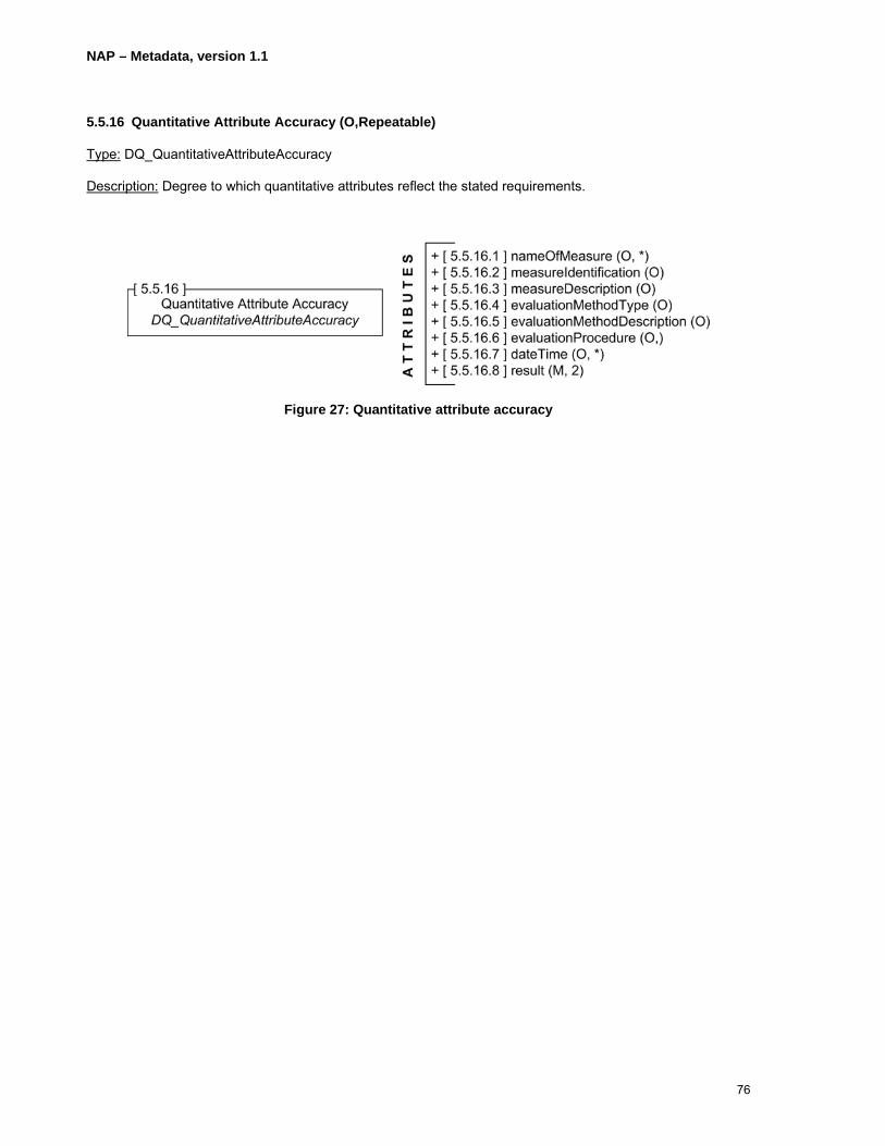
5.5.16 Quantitative Attribute Accuracy (O,Repeatable)
Type: DQ_QuantitativeAttributeAccuracy
Description: Degree to which quantitative attributes reflect the stated requirements.
Figure 27: Quantitative attribute accuracy

NAP – Metadata, version 1.1
77
Clause No
Name/ RoleName Multiplicity Type Description Best Practices
5.5.16.1 nameOfMeasure O,Repeatable free text (CharacterString) Name of the test applied to the data to assure data quality.
5.5.16.2 measureIdentification O MD_Identifier (see 5.22) Code which identifies a registered standard data quality procedure.
5.5.16.3 measureDescription O free text (CharacterString) Description of the measure applied to the dataset to assure quality.
5.5.16.4 evaluationMethodType O CodeList napDQ_EvaluationMethodTypeCode
Method type used to evaluate data quality in the dataset.
Select evaluationMethodType from napDQ_EvaluationMethodTypeCode.
5.5.16.5 evaluationMethodDescription O free text (CharacterString) Description of the evaluation method applied to the dataset.
5.5.16.6 evaluationProcedure O CI_Citation (see 5.15) Citation for the evaluation procedure.
Strongly recommend to provide contact information (see 5.16.4) under cited responsible party (see 5.14.7).
5.5.16.7 dateTime O,Repeatable DateTime (see B.5) Date and time at which the test was completed.
DateTime cannot support the description of duration; only single time is allowed.
5.5.16.8 result M,2 DQ_QuantitativeResult (see 5.5.20) and/or DQ_ConformanceResult (see 5.5.21)
Value(s) obtained from data quality test or outcome from applying data quality measure against a specified/acceptable quality conformance level.
NAP – Metadata, version 1.1
78
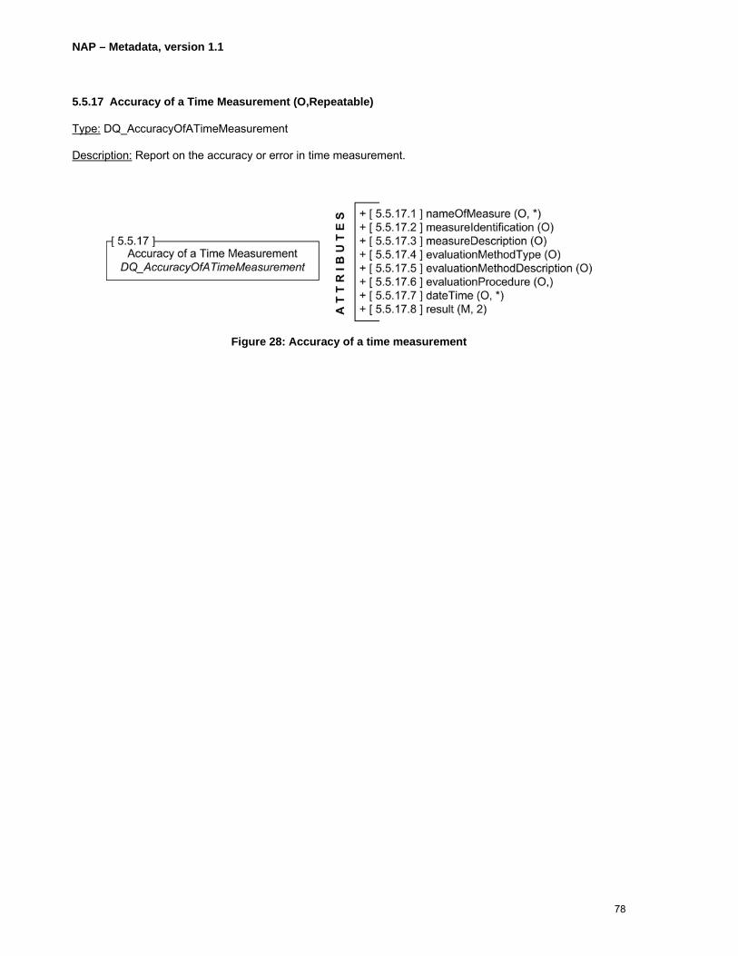
5.5.17 Accuracy of a Time Measurement (O,Repeatable)
Type: DQ_AccuracyOfATimeMeasurement
Description: Report on the accuracy or error in time measurement.
Figure 28: Accuracy of a time measurement

NAP – Metadata, version 1.1
79
Clause No
Name/ RoleName Multiplicity Type Description Best Practices
5.5.17.1 nameOfMeasure O,Repeatable free text (CharacterString) Name of the test applied to the data to assure data quality.
5.5.17.2 measureIdentification O MD_Identifier (see 5.22) Code which identifies a registered standard data quality procedure.
5.5.17.3 measureDescription O free text (CharacterString) Description of the measure applied to the dataset to assure quality.
5.5.17.4 evaluationMethodType O CodeList napDQ_EvaluationMethodTypeCode
Method type used to evaluate data quality in the dataset.
Select evaluationMethodType from napDQ_EvaluationMethodTypeCode.
5.5.17.5 evaluationMethodDescription O free text (CharacterString) Description of the evaluation method applied to the dataset.
5.5.17.6 evaluationProcedure O CI_Citation (see 5.14) Citation for the evaluation procedure.
Strongly recommend to provide contact information (see 5.16.4) under cited responsible party (see 5.14.7).
5.5.17.7 dateTime O,Repeatable DateTime (see B.5) Date and time at which the test was completed.
DateTime cannot support the description of duration; only single time is allowed.
5.5.17.8 result M,2 DQ_QuantitativeResult (see 5.5.20) and/or DQ_ConformanceResult (see 5.5.21)
Value(s) obtained from data quality test or outcome from applying data quality measure against a specified/acceptable quality conformance level.
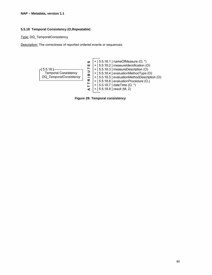
NAP – Metadata, version 1.1
80
5.5.18 Temporal Consistency (O,Repeatable)
Type: DQ_TemporalConsistency
Description: The correctness of reported ordered events or sequences.
Figure 29: Temporal consistency

NAP – Metadata, version 1.1
81
Clause No
Name/ RoleName Multiplicity Type Description Best Practices
5.5.18.1 nameOfMeasure O,Repeatable free text (CharacterString) Name of the test applied to the data to assure data quality.
5.5.18.2 measureIdentification O MD_Identifier (see 5.22) Code which identifies a registered standard data quality procedure.
5.5.18.3 measureDescription O free text (CharacterString) Description of the measure applied to the dataset to assure quality.
5.5.18.4 evaluationMethodType O CodeList napDQ_EvaluationMethodTypeCode
Method type used to evaluate data quality in the dataset.
Select evaluationMethodType from napDQ_EvaluationMethodTypeCode.
5.5.18.5 evaluationMethodDescription O free text (CharacterString) Description of the evaluation method applied to the dataset.
5.5.18.6 evaluationProcedure O CI_Citation (see 5.14) Citation for the evaluation procedure.
Strongly recommend to provide contact information (see 5.16.4) under cited responsible party (see 5.14.7).
5.5.18.7 dateTime O,Repeatable DateTime (see B.5) Date and time at which the test was completed.
DateTime cannot support the description of duration; only single time is allowed.
5.5.18.8 result M,2 DQ_QuantitativeResult (see 5.5.20) and/or DQ_ConformanceResult (see 5.5.21)
Value(s) obtained from data quality test or outcome from applying data quality measure against a specified/acceptable quality conformance level.

NAP – Metadata, version 1.1
82
5.5.19 Scope Description
Type: MD_ScopeDescription
Description: Description of the class of information covered by the information.
BP: One and only one of the following must be entered: attributes, features, featureInstances, attributeInstances, dataset, or other as appropriate.
Figure 30: Scope description

NAP – Metadata, version 1.1
83
Clause No
Name/ RoleName Multiplicity Type Description Best Practices
5.5.19.1 attributes O Set<GF_AttributeType> (see B.9) Set of attribute types specifying the range and extent of the scope.
Mandatory if features, featureInstances, attributeInstances, dataset, or other are not documented.
5.5.19.2 features O Set<GF_FeatureType> (see B.10) Set of feature types specifying the range and extent of the scope.
Mandatory if attributes, featureInstances, attributeInstances, dataset, or other are not documented.
5.5.19.3 featureInstances O Set<GF_FeatureType> (see B.10) Set of feature instances specifying the range and extent of the scope.
Mandatory if attributes, features, attributeInstances, dataset, or other are not documented. featureInstances should refer to a set of occurrences of feature types.
5.5.19.4 attributeInstances O Set<GF_AttributeType> (see B.9) Set of attribute instances specifying the range and extent of the scope.
Mandatory if attributes, features, featureInstances, dataset, or other are documented. attributeInstances should refer to a set of occurrences of attribute types.
5.5.19.5 dataset O free text (CharacterString) Dataset identifier specifying the range and extent of the scope.
Mandatory if attributes, features, featureInstances, attributeInstances, or other are not documented.
5.5.19.6 other O free text (CharacterString) Information specifying the range and extent of the scope that is not covered under attributes, features, featureInstances, attributeInstances, and dataset.
Mandatory if attributes, features, featureInstances, attributeInstances, or dataset are not documented.
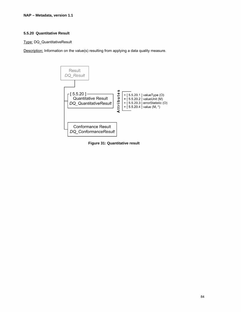
NAP – Metadata, version 1.1
84
5.5.20 Quantitative Result
Type: DQ_QuantitativeResult
Description: Information on the value(s) resulting from applying a data quality measure.
Figure 31: Quantitative result

NAP – Metadata, version 1.1
85
Clause No
Name/ RoleName Multiplicity Type Description Best Practices
5.5.20.1 valueType O RecordType (see B.18) The class or classes used for the value type(s).
5.5.20.2 valueUnit M UnitOfMeasure (see B.24) Any system devised to quantify a value such as length, time, angle, area, volume, velocity, or scale.
5.5.20.3 errorStatistic O free text (CharacterString) The statistical method used to estimate error in the value.
As part of the description of the statistical method, the confidence interval (e.g. 95% confidence level) of an accuracy value should be specified.
5.5.20.4 value M,Repeatable Record (see B.17) The quantitative value(s) for the object measured.
If the attribute valueType is not used then, this attribute will consist of a single (or list of) values(s). If this attribute is a matrix, as in a covariance matrix, the structure must be described in valueType (6.5.21.1) with the type RecordType.

NAP – Metadata, version 1.1
86
5.5.21 Conformance Result
Type: DQ_ConformanceResult
Description: Information which describes the outcome from evaluating the value(s) against a set acceptable quality level.
Figure 32: Conformance result

NAP – Metadata, version 1.1
87
Clause No
Name/ RoleName Multiplicity Type Description Best Practices
5.5.21.1 specification M CI_Citation (see 5.14) Citation for the specification or user requirement used to evaluate the data.
5.5.21.2 explanation M free text (CharacterString) An explanation of the conformance result.
5.5.21.3 pass M Boolean (see B.2) Notification of whether the data passed or failed the conformance test.
Enter “0” for failed or “1” for passed.

NAP – Metadata, version 1.1
88
5.5.22 Source
Type: LI_Source
Description: Information about the source data used in creating the data within the specified Scope.
BP: It is strongly recommended that the attribute description or the pair of attributes – sourceCitation and sourceExtent – shall be provided.
Figure 33: Source
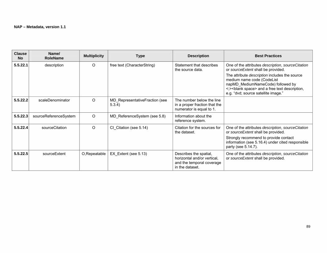
NAP – Metadata, version 1.1
89
Clause No
Name/ RoleName Multiplicity Type Description Best Practices
5.5.22.1 description O free text (CharacterString) Statement that describes the source data.
One of the attributes description, sourceCitation or sourceExtent shall be provided. The attribute description includes the source medium name code (CodeList napMD_MediumNameCode) followed by <;><blank space> and a free text description, e.g. “dvd; source satellite image.”
5.5.22.2 scaleDenominator O MD_RepresentativeFraction (see 5.3.4)
The number below the line in a proper fraction that the numerator is equal to 1.
5.5.22.3 sourceReferenceSystem O MD_ReferenceSystem (see 5.8) Information about the reference system.
5.5.22.4 sourceCitation O CI_Citation (see 5.14) Citation for the sources for the dataset.
One of the attributes description, sourceCitation or sourceExtent shall be provided. Strongly recommend to provide contact information (see 5.16.4) under cited responsible party (see 5.14.7).
5.5.22.5 sourceExtent O,Repeatable EX_Extent (see 5.13) Describes the spatial, horizontal and/or vertical, and the temporal coverage in the dataset.
One of the attributes description, sourceCitation or sourceExtent shall be provided.

NAP – Metadata, version 1.1
90
5.5.23 Process Step
Type: LI_ProcessStep
Description: The events in the development of the dataset.
Figure 34: Process step

NAP – Metadata, version 1.1
91
Clause No
Name/ RoleName Multiplicity Type Description Best Practices
5.5.23.1 description M free text (CharacterString) Description of the processes performed on the data.
5.5.23.2 rationale O free text (CharacterString) Purpose for performing the process on the data.
5.5.23.3 dateTime1 O DateTime (see B.5) The date and time when the process was completed.
Only single time is allowed.
5.5.23.4 processor O,Repeatable CI_ResponsibleParty (see 5.16) Identification and means to contact the person or party that performed the process.
1 dateTime cannot support the description of duration.
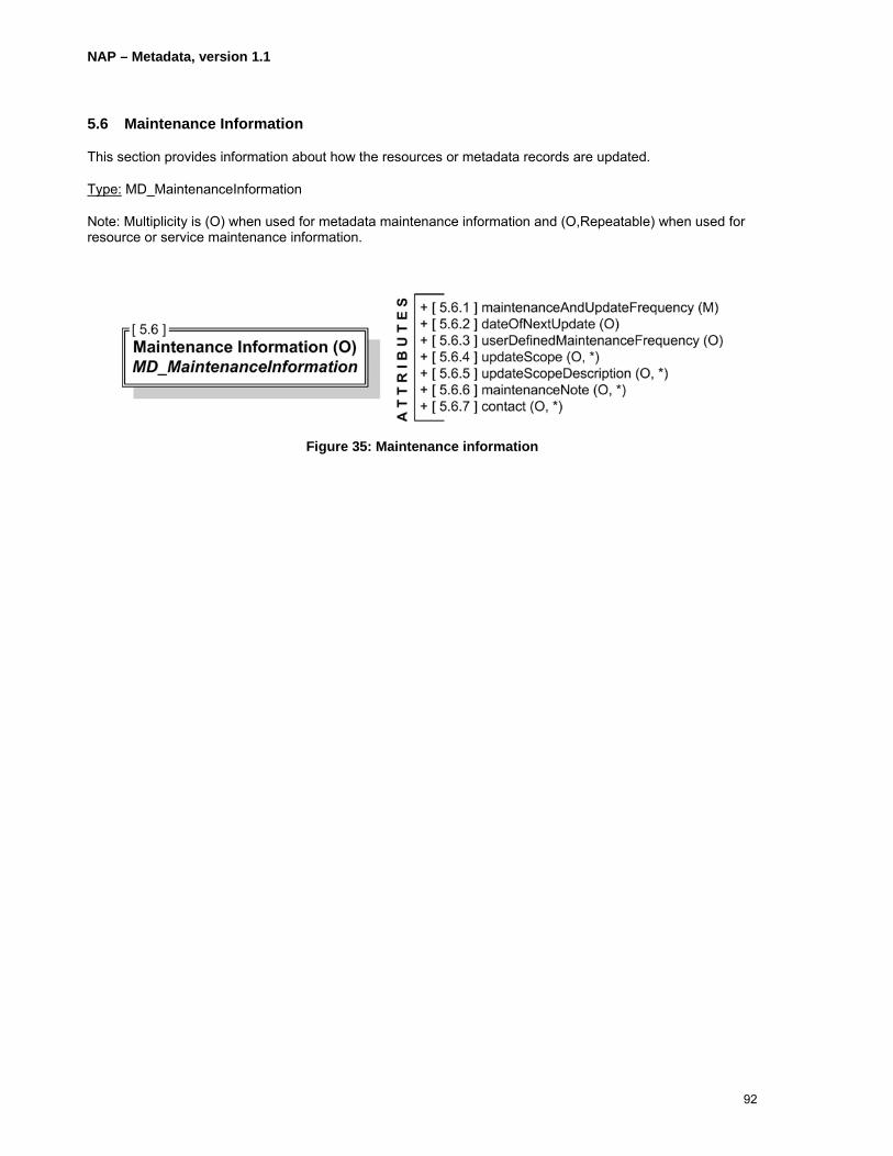
NAP – Metadata, version 1.1
92
5.6 Maintenance Information
This section provides information about how the resources or metadata records are updated.
Type: MD_MaintenanceInformation
Note: Multiplicity is (O) when used for metadata maintenance information and (O,Repeatable) when used for resource or service maintenance information.
Figure 35: Maintenance information

NAP – Metadata, version 1.1
93
Clause No
Name/ RoleName Multiplicity Type Description Best Practices
5.6.1 maintenanceAndUpdateFrequency M CodeList napMD_MaintenanceFrequencyCode
Frequency of changes and additions made to the resource after the initial completion.
For example, maintenanceAndUpdateFrequency could be used when dateOfNextUpdate (see 5.6.2) uses the date of the resource (5.14.3) under citation (see 5.3.1.1) and the metadata date stamp (see 5.2.7) of the metadata record information (see 5.2) are automatically updated. Select maintenanceAndUpdateFrequency from napMD_MaintenanceFrequencyCode.
5.6.2 dateOfNextUpdate O Date (see B.4) The scheduled revision date for the resource.
This could be calculated based on the resource reference date (see 5.3.1.1) and the maintenance and update frequency code (see 5.6.1). Typically, this date should become the date of the next resource version, which will be reported in the date of the resource (5.14.3) under citation (see 5.3.1.1), and possibly the next date stamp (see 5.2.7) of its metadata.
5.6.3 userDefinedMaintenanceFrequency O TM_PeriodDuration (see B.21) The maintenance period other than those defined.
This value corresponds to the longest period but could be shorter.
5.6.4 updateScope O,Repeatable CodeList napMD_ScopeCode Scope of data to which maintenance is applied.
Select updateCode from napMD_ScopeCode.
5.6.5 updateScopeDescription O,Repeatable MD_ScopeDescription (see 5.5.19) Additional information about the range or extent of the resource.

NAP – Metadata, version 1.1
94
5.6.6 maintenanceNote O,Repeatable free text (CharacterString) Information regarding specific requirements for maintaining the resource.
5.6.7 contact O,Repeatable CI_ResponsibleParty (see 5.16) Identification of and means of communicating with, person and organization with responsibility for maintaining the resource.
Contact information (see 5.16.4 contactInfo) shall be provided.

NAP – Metadata, version 1.1
95
(Page intentionally left blank)

NAP – Metadata, version 1.1
96
5.7 Spatial Representation Information (O,Repeatable)
This section describes attributes and components that provide information about spatial representation information.
Type: MD_GridSpatialRepresentation (see 5.7.1) and/or MD_VectorSpatialRepresentation (see 5.7.2) and/or MD_Georectified (see 5.7.3) and/or MD_Georeferenceable (see5.7.4)
Figure 36: Spatial representation information

NAP – Metadata, version 1.1
97
Clause No
Name/ RoleName Multiplicity Type Description Best Practices
5.7.1 Grid Spatial Representation MD_GridSpatialRepresentation Information on the grid system used in the dataset.
Required if dataset objects are gridded.
5.7.1.1 numberOfDimensions M Integer (see B.13) The number of independent spatio-temporal axes.
5.7.1.2 axisDimensionProperties M Sequence<MD_Dimension> (see 5.7.5)
Information on the dimension name, size, and resolution used.
5.7.1.3 cellGeometry M CodeList napMD_CellGeometryCode
Identification of grid data as point or cell.
Select cellGeometry from napMD_CellGeometryCode.
5.7.1.4 transformationParameterAvailability M Boolean (see B.2) Indication of image coordinates and geographic or map coordinates availability.
1 = Yes, 0 = No
5.7.2 Vector Spatial Representation MD_VectorSpatialRepresentation Information about the vector objects in the dataset.
Vector Spatial Representation is required if point or vector objects exist in the dataset. Either topologyLevel or geometricObjects shall be provided, or both.
5.7.2.1 topologyLevel O CodeList napMD_TopologyLevelCode
Code to identify topology level in the dataset.
Select topologyLevel from napMD_TopologyLevelCode.
5.7.2.2 geometricObjects O,Repeatable MD_GeometricObjects (see 5.7.6) Identification of the objects used to represent features in the dataset.
5.7.3 Georectified Grid Information MD_Georectified Information on the grid used to georectify the data.
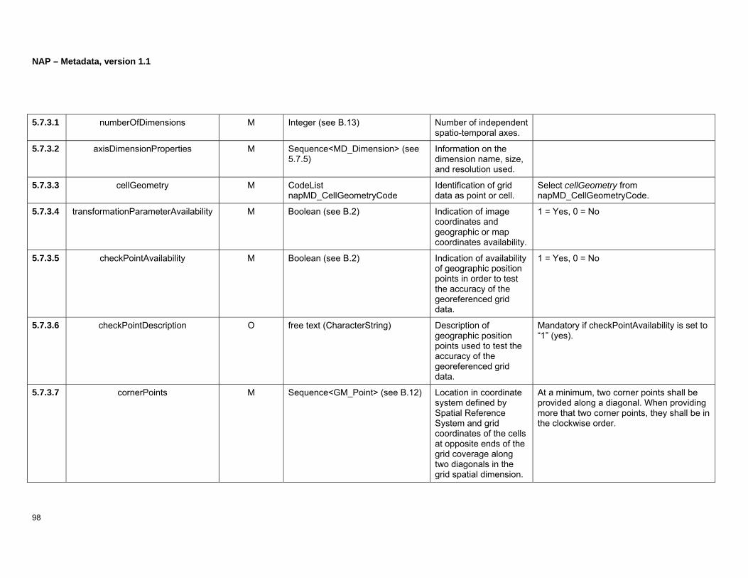
NAP – Metadata, version 1.1
98
5.7.3.1 numberOfDimensions M Integer (see B.13) Number of independent spatio-temporal axes.
5.7.3.2 axisDimensionProperties M Sequence<MD_Dimension> (see 5.7.5)
Information on the dimension name, size, and resolution used.
5.7.3.3 cellGeometry M CodeList napMD_CellGeometryCode
Identification of grid data as point or cell.
Select cellGeometry from napMD_CellGeometryCode.
5.7.3.4 transformationParameterAvailability M Boolean (see B.2) Indication of image coordinates and geographic or map coordinates availability.
1 = Yes, 0 = No
5.7.3.5 checkPointAvailability M Boolean (see B.2) Indication of availability of geographic position points in order to test the accuracy of the georeferenced grid data.
1 = Yes, 0 = No
5.7.3.6 checkPointDescription O free text (CharacterString) Description of geographic position points used to test the accuracy of the georeferenced grid data.
Mandatory if checkPointAvailability is set to “1” (yes).
5.7.3.7 cornerPoints M Sequence<GM_Point> (see B.12) Location in coordinate system defined by Spatial Reference System and grid coordinates of the cells at opposite ends of the grid coverage along two diagonals in the grid spatial dimension.
At a minimum, two corner points shall be provided along a diagonal. When providing more that two corner points, they shall be in the clockwise order.

NAP – Metadata, version 1.1
99
5.7.3.8 centerPoint O GM_Point (see B.12) Earth location, represented as a point, in the coordinate system defined by the Spatial Reference System and the grid coordinate of the cell halfway between opposite ends of the grid.
5.7.3.9 pointInPixel M CodeList napMD_PixelOrientationCode
Point in a pixel corresponding to the Earth location of the pixel.
Select pointInPixel from napMD_PixelOrientationCode.
5.7.3.10 transformationDimensionDescription O free text (CharacterString) General description of the transformation.
5.7.3.11 transformationDimensionMapping O,2 free text (CharacterString) Information about which grid axes are spatial axes.
5.7.4 Georeferenceable Grid Information MD_Georeferenceable Information on georeferencing the dataset.
5.7.4.1 numberOfDimensions M Integer (see B.13) Number of independent spatio-temporal axes.
5.7.4.2 axisDimensionProperties M Sequence<MD_Dimension> (see 5.7.5)
Information on the dimension name, size, and resolution used.
5.7.4.3 cellGeometry M CodeList napMD_CellGeometryCode
Identification of grid data as point or cell.
Select cellGeometry from napMD_CellGeometryCode.
5.7.4.4 transformationParameterAvailability M Boolean (see B.2) Indication of image coordinates and

NAP – Metadata, version 1.1
100
geographic or map coordinates availability.
5.7.4.5 controlPointAvailability M Boolean (see B.2) Indication of control point existence.
5.7.4.6 orientationParameterAvailability M Boolean (see B.2) Indication of orientation parameters availability.
5.7.4.7 orientationParameterDescription O free text (CharacterString) Description of parameters used to describe sensor orientation.
5.7.4.8 georeferencedParameters M Record (see B.17) Terms which support grid data georeferencing.
5.7.4.9 parameterCitation O,Repeatable CI_Citation (see 5.14) Citation for the parameter reference
Strongly recommend to provide contact information (see 5.16.4) under cited responsible party (see 5.14.7).

NAP – Metadata, version 1.1
101
(Page intentionally left blank)

NAP – Metadata, version 1.1
102
5.7.5 Dimension
Type: MD_Dimension
Description: Information on the dimension name, size, and resolution used.
Figure 37: Dimension
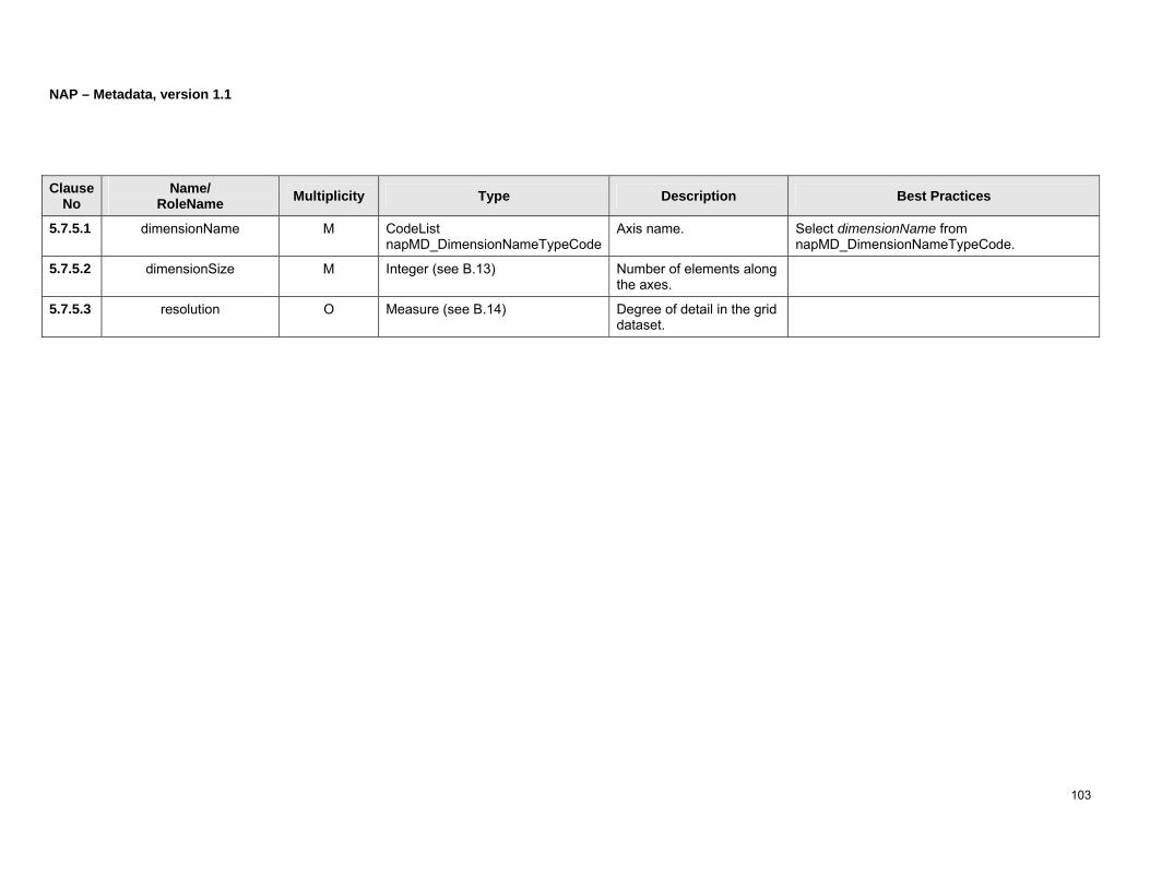
NAP – Metadata, version 1.1
103
Clause No
Name/ RoleName Multiplicity Type Description Best Practices
5.7.5.1 dimensionName M CodeList napMD_DimensionNameTypeCode
Axis name. Select dimensionName from napMD_DimensionNameTypeCode.
5.7.5.2 dimensionSize M Integer (see B.13) Number of elements along the axes.
5.7.5.3 resolution O Measure (see B.14) Degree of detail in the grid dataset.
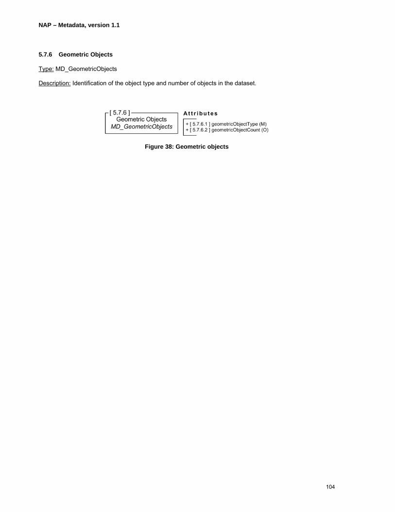
NAP – Metadata, version 1.1
104
5.7.6 Geometric Objects
Type: MD_GeometricObjects
Description: Identification of the object type and number of objects in the dataset.
Figure 38: Geometric objects

NAP – Metadata, version 1.1
105
Clause No
Name/ RoleName Multiplicity Type Description Best Practices
5.7.6.1 geometricObjectType M CodeList napMD_GeometricObjectTypeCode
Name of point or vector objects to locate zero, one, two or three dimensional locations in the dataset.
Select geometricObjectType from napMD_GeometricObjectTypeCode.
5.7.6.2 geometricObjectCount O Integer (see B.13) Total number of point or vector objects in the dataset.
Value greater than “0”.

NAP – Metadata, version 1.1
106
5.8 Reference System Information (C,Repeatable)
This section describes attributes that provide information about reference system information.
Type: MD_ReferenceSystem
Description: Identification of the spatial and temporal reference systems used.
Figure 39: Reference system information

NAP – Metadata, version 1.1
107
Clause No
Name/ RoleName Multiplicity Type Description Best Practices
5.8.1 referenceSystemIdentifier M RS_Identifier (see 5.8.2) Identifier of the Reference System.
A coordinate reference system (CRS) should be taken from a publicly available register or document. If a coordinate reference system (CRS) is not available from a publicly available register or document and as such has no identifier or well known name, then that CRS shall be described according to ISO/FDIS19111rev. and ISO/TS19127. An identifier or well known name with an authority is then defined and referenced here. Note: A CRS identifier should be taken from a register such as EPSG2 Geodetic Parameter Dataset (http://www.epsg.org/).
2 A CRS identifier should be taken from a register such as EPSG Geodetic Parameter Dataset (http://www.epsg.org/)
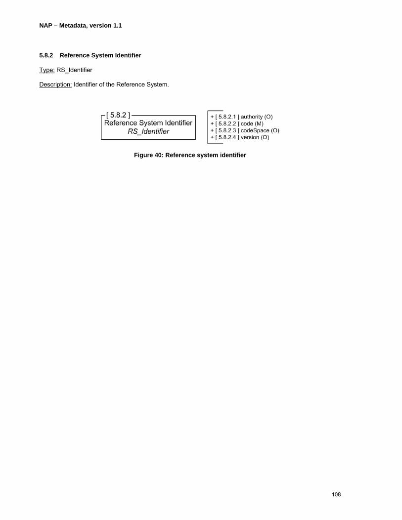
NAP – Metadata, version 1.1
108
5.8.2 Reference System Identifier
Type: RS_Identifier
Description: Identifier of the Reference System.
Figure 40: Reference system identifier

NAP – Metadata, version 1.1
109
Clause No
Name/ RoleName Multiplicity Type Description Best Practices
5.8.2.1 authority O CI_Citation (see 5.14) The party responsible for maintenance of the reference system resource.
Strongly recommend to provide contact information (see 5.16.4) under cited responsible party (see 5.14.7).
5.8.2.2 code M free text (CharacterString) The alphanumeric value identifying the source reference system, e.g. “epsg.”
5.8.2.3 codeSpace O free text (CharacterString) Identifier/namespace of the system in which the code is valid, e.g. “http://www.epsg.org/databases/epsg-v6_13.zip.”
5.8.2.4 version O free text (CharacterString) The cited reference system version, e.g. “6.13.”

NAP – Metadata, version 1.1
110
5.9 Content Information (O,Repeatable)
This section describes attributes and components that provide information about content information.
Type: MD_FeatureCatalogueDescription and/or MD_CoverageDescription and/or MD_Image
Description: Describes the dataset content.
BP: Although features are normally listed in a Feature Catalogue, it is convenient to make them part of this metadata record by also listing these in 5.9.1.4 as the catalogue may not be easily accessible.
Figure 41: Content information
The following subitems with their attributes and components provide information about content.

NAP – Metadata, version 1.1
111
Clause No
Name/ RoleName Multiplicity Type Description Best Practices
5.9.1 Feature Catalogue Description MD_FeatureCatalogueDescription Identification of the feature catalogue or the conceptual schema.
5.9.1.1 complianceCode O Boolean (see B.2) Indication of whether the cited feature catalogue complies with ISO19110.
“0” means not compliant and “1” means compliant.
5.9.1.2 language O,Repeatable free text (CharacterString) Language and character coding standards of the feature catalogue.
Three letter language code, a three letter country code, and character coding code:
<ISO639-2/T three letter language code><;><blank space><ISO3166-1 three letter country code><;><blank space><character set code>
e.g. fra; CAN; utf8 Note: see http://www.loc.gov/standards/iso639-2/php/English_list.php for ISO639-2/T language codes; see http://userpage.chemie.fu-berlin.de/diverse/doc/ISO_3166.html for ISO3166-1 country codes; See CodeList napMD_CharacterSetCode for character set codes.
5.9.1.3 includedWithDataset M Boolean (see B.2) Is the feature catalogue included with the dataset?
“0” means not included and “1” means included.
5.9.1.4 featureTypes M,Repeatable GenericName (see B.8) Feature type identifier and/or
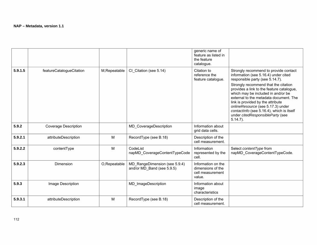
NAP – Metadata, version 1.1
112
generic name of feature as listed in the feature catalogue.
5.9.1.5 featureCatalogueCitation M,Repeatable CI_Citation (see 5.14) Citation to reference the feature catalogue.
Strongly recommend to provide contact information (see 5.16.4) under cited responsible party (see 5.14.7). Strongly recommend that the citation provides a link to the feature catalogue, which may be included in and/or be external to the metadata document. The link is provided by the attribute onlineResource (see 5.17.3) under contactInfo (see 5.16.4), which is itself under citedResponsibleParty (see 5.14.7).
5.9.2 Coverage Description MD_CoverageDescription Information about grid data cells.
5.9.2.1 attributeDescription M RecordType (see B.18) Description of the cell measurement.
5.9.2.2 contentType M CodeList napMD_CoverageContentTypeCode
Information represented by the cell.
Select contentType from napMD_CoverageContentTypeCode.
5.9.2.3 Dimension O,Repeatable MD_RangeDimension (see 5.9.4) and/or MD_Band (see 5.9.5)
Information on the dimensions of the cell measurement value.
5.9.3 Image Description MD_ImageDescription Information about image characteristics
5.9.3.1 attributeDescription M RecordType (see B.18) Description of the cell measurement.

NAP – Metadata, version 1.1
113
5.9.3.2 contentType M CodeList napMD_CoverageContentTypeCode
Information represented by the cell.
Select contentType from napMD_CoverageContentTypeCode.
5.9.3.3 illuminationElevationAngle O Real (see B.16) Illumination elevation measured in degrees clockwise for the target plane at intersection of the optical line of sight with the Earth’s surface.
Value domain is [-90, 90]. For scanned images, refer to the center pixel of the image.
5.9.3.4 illuminationAzimuthAngle O Real (see B.16) Illumination azimuth measured in degrees clockwise from true north at the time the image is taken.
Value domain is [-0, 360]. Reference the center pixel of the image for scanned images.
5.9.3.5 imagingCondition O CodeList napMD_ImagingConditionCode
Conditions affecting the image.
Select imagingCondition from napMD_ImagingConditionCode.
5.9.3.6 imagingQualityCode O MD_Identifier (see 5.22) Specifies the image quality.
5.9.3.7 cloudCoverPercentage O Real (see B.16) Percentage of dataset area obscured by clouds.
Value domain is [-0.0, 100.0].
5.9.3.8 processingLevelCode O MD_Identifier (see 5.22) Identification of the image processing level.
5.9.3.9 compressionGenerationQuantity O Integer (see B.13) The number of compression
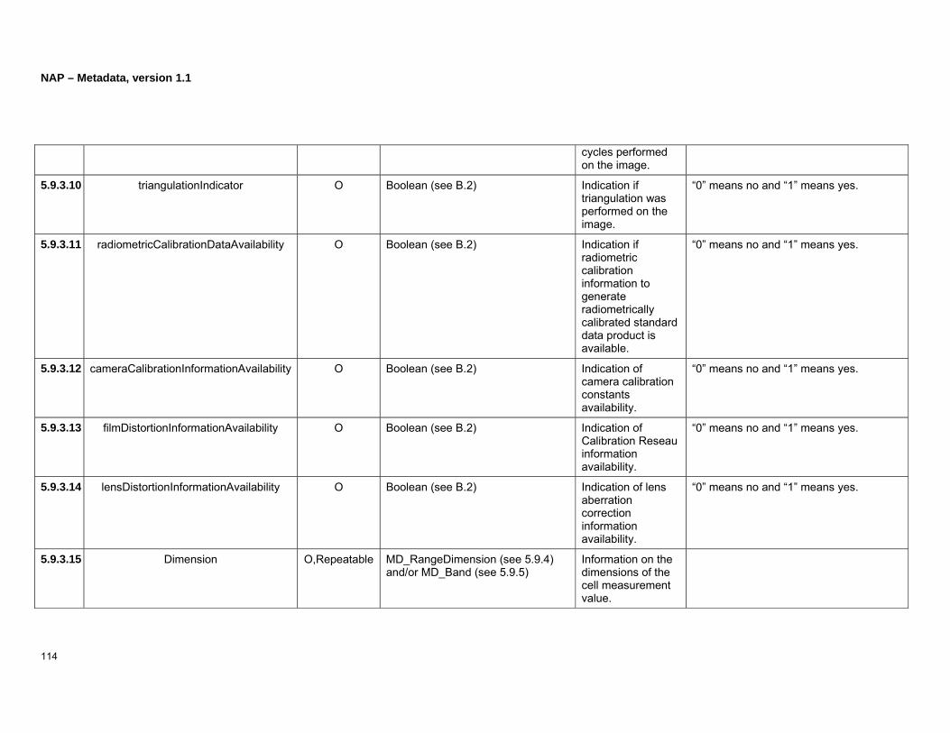
NAP – Metadata, version 1.1
114
cycles performed on the image.
5.9.3.10 triangulationIndicator O Boolean (see B.2) Indication if triangulation was performed on the image.
“0” means no and “1” means yes.
5.9.3.11 radiometricCalibrationDataAvailability O Boolean (see B.2) Indication if radiometric calibration information to generate radiometrically calibrated standard data product is available.
“0” means no and “1” means yes.
5.9.3.12 cameraCalibrationInformationAvailability O Boolean (see B.2) Indication of camera calibration constants availability.
“0” means no and “1” means yes.
5.9.3.13 filmDistortionInformationAvailability O Boolean (see B.2) Indication of Calibration Reseau information availability.
“0” means no and “1” means yes.
5.9.3.14 lensDistortionInformationAvailability O Boolean (see B.2) Indication of lens aberration correction information availability.
“0” means no and “1” means yes.
5.9.3.15 Dimension O,Repeatable MD_RangeDimension (see 5.9.4) and/or MD_Band (see 5.9.5)
Information on the dimensions of the cell measurement value.
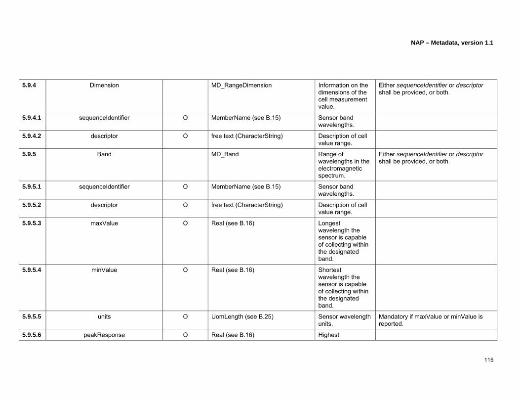
NAP – Metadata, version 1.1
115
5.9.4 Dimension MD_RangeDimension Information on the dimensions of the cell measurement value.
Either sequenceIdentifier or descriptor shall be provided, or both.
5.9.4.1 sequenceIdentifier O MemberName (see B.15) Sensor band wavelengths.
5.9.4.2 descriptor O free text (CharacterString) Description of cell value range.
5.9.5 Band MD_Band Range of wavelengths in the electromagnetic spectrum.
Either sequenceIdentifier or descriptor shall be provided, or both.
5.9.5.1 sequenceIdentifier O MemberName (see B.15) Sensor band wavelengths.
5.9.5.2 descriptor O free text (CharacterString) Description of cell value range.
5.9.5.3 maxValue O Real (see B.16) Longest wavelength the sensor is capable of collecting within the designated band.
5.9.5.4 minValue O Real (see B.16) Shortest wavelength the sensor is capable of collecting within the designated band.
5.9.5.5 units O UomLength (see B.25) Sensor wavelength units.
Mandatory if maxValue or minValue is reported.
5.9.5.6 peakResponse O Real (see B.16) Highest
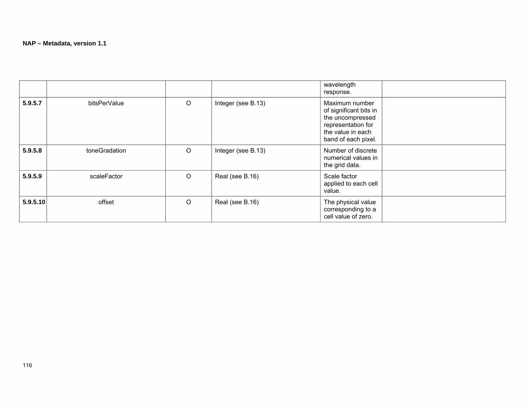
NAP – Metadata, version 1.1
116
wavelength response.
5.9.5.7 bitsPerValue O Integer (see B.13) Maximum number of significant bits in the uncompressed representation for the value in each band of each pixel.
5.9.5.8 toneGradation O Integer (see B.13) Number of discrete numerical values in the grid data.
5.9.5.9 scaleFactor O Real (see B.16) Scale factor applied to each cell value.
5.9.5.10 offset O Real (see B.16) The physical value corresponding to a cell value of zero.

NAP – Metadata, version 1.1
117
(Page intentionally left blank)

NAP – Metadata, version 1.1
118
5.10 Portrayal Catalogue Information (O,Repeatable)
This section describes attributes that provide information about portrayal catalogue information.
Note: A portrayal catalogue is a collection of defined symbols used to depict, to humans, features on a map.
Type: MD_PortrayalCatalogueReference
Description: Information used to identify and locate the portrayal catalogue.
Figure 42: Portrayal catalogue information
The following attribute provides information about portrayal catalogue.

NAP – Metadata, version 1.1
119
Clause No
Name/ RoleName Multiplicity Type Description Best Practices
5.10.1 portrayalCatalogueCitation M,Repeatable CI_Citation (see 5.14) Bibliographic citation for the portrayal catalogue.
Strongly recommend to provide contact information (see 5.16.4) under cited responsible party (see 5.14.7).

NAP – Metadata, version 1.1
120
5.11 Distribution Information (O)
This section describes attributes and components that provide information about distribution information.
Type: MD_Distribution
Description: Information about the dataset distributor and options to obtain the dataset.
Figure 43: Distribution information

NAP – Metadata, version 1.1
121
Clause No
Name/ RoleName Multiplicity Type Description Best Practices
5.11.1 Transfer Options O,Repeatable MD_DigitalTransferOptions The means and media by which the data/dataset is obtained from the distributor.
5.11.1.1 unitsOfDistribution O free text (CharacterString) Tiles, layers, geographic areas, etc. in which the data is available.
5.11.1.2 transferSize O Real (see B.16) Estimated size of the transfer unit in the specified format, expressed in megabytes.
Value greater than “0.0.”
5.11.1.3 onLine O,Repeatable CI_OnlineResource (see 5.20) Information about the online sources where the data/dataset may be obtained.
5.11.1.4 offLine O MD_Medium (see 5.11.8) Information about the offline distribution media.
5.11.2 Distributor C,Repeatable MD_Distributor Information about the data distributor.
Mandatory if Distribution Format information is not provided.
5.11.2.1 distributorContact M CI_ResponsibleParty (see 5.16) Information on party responsible for dataset distribution.
If the distributor name or position name is not known then organization name is required. Contact information (see 5.16.4 contactInfo) shall be provided.
5.11.2.2 Distribution Order Process O,Repeatable MD_StandardOrderProcess (see 5.11.4)
The process to follow when obtaining the dataset.
5.11.3 Distribution Format C,Repeatable MD_Format Description of distribution format.
Mandatory if Distributor information is not provided.

NAP – Metadata, version 1.1
122
5.11.3.1 name M free text (CharacterString) Name of the data transfer format.
5.11.3.2 version M free text (CharacterString) Version of the format (date, number, etc).
5.11.3.3 amendmentNumber O free text (CharacterString) Format version amendment number.
5.11.3.4 specification O free text (CharacterString) The subset name, profile, or product specification of the format.
5.11.3.5 fileDecompressionTechnique O free text (CharacterString) Description of recommended processes or algorithms to apply to the compressed resource.

NAP – Metadata, version 1.1
123
(Page intentionally left blank)

NAP – Metadata, version 1.1
124
5.11.4 Standard Order Process
Type: MD_StandardOrderProcess
Description: The process in which the resource is obtained or received and other related instructions or fee information.
BP: At least one of fees, plannedAvailableDateTime, orderingInstructions or turnaround shall be provided.
Figure 44: Standard order process

NAP – Metadata, version 1.1
125
Clause No
Name/ RoleName Multiplicity Type Description Best Practices
5.11.4.1 fees O free text (CharacterString) Fees and terms for obtaining the data/dataset.
Incude at the end an monetary units alphabetic code as specified in ISO 4217 (see http://www.iso.org/iso/en/prods-services/popstds/currencycodeslist.html) e.g. 300.00USD 299.99CAD
5.11.4.2 plannedAvailableDateTime O DateTime (see B.5) Date and time the resource will be available.
5.11.4.3 orderingInstructions O free text (CharacterString) General instructions, terms, and services provided by the data distributor.
5.11.4.4 turnaround O free text (CharacterString) Typical time required for filling a data request.

NAP – Metadata, version 1.1
126
5.11.5 Medium
Type: MD_Medium
Description: Information on the name, density, density units, volumes, medium format, and medium note used to describe the transfer of data to a medium.
BP: At least one of name, density, volumes, mediumFormat or mediumNote shall be provided. DensityUnits is mandatory if density is provided.
Figure 45: Medium

NAP – Metadata, version 1.1
127
Clause No
Name/ RoleName Multiplicity Type Description Best Practices
5.11.5.1 name O CodeList napMD_MediumNameCode
Medium name code. Select medium name from napMD_MediumNameCode.
5.11.5.2 density O,Repeatable Real (see B.16) The recording density on the specified media.
Value greater than “0.0.”
5.11.5.3 densityUnits C free text (CharacterString) The recording density units.
dentityUnits is mandatory when density is recorded.
5.11.5.4 volumes O Integer (see B.13) Identification of the number of recorded items on the media.
Value greater than “0.”
5.11.5.5 mediumFormat O,Repeatable CodeList napMD_MediumFormatCode
Method used to write to the medium.
Select mediumFormat from napMD_MediumFormatCode.
5.11.5.6 mediumNote O free text (CharacterString) Description of limitations or requirements for using the medium.

NAP – Metadata, version 1.1
128
5.12 Application Schema Information (O,Repeatable)
This section describes attributes that provide information about application schema information.
Type: MD_ApplicationSchemaInformation
Description: Information about the application schema used to develop the dataset.
Figure 46: Application schema information

NAP – Metadata, version 1.1
129
Clause No
Name/ RoleName Multiplicity Type Description Best Practices
5.12.1.1 name M CI_Citation (see 5.14) Citation for the application schema.
Strongly recommend to provide contact information (see 5.16.4) under cited responsible party (see 5.14.7).
5.12.1.2 schemaLanguage M free text (CharacterString) identification of the schema language.
5.12.1.3 constraintLanguage M free text (CharacterString) Identification of the formal language used to describe constraints in the application schema.
5.12.1.4 schemaAscii O free text (CharacterString) Full application schema given as an ASCII file.
5.12.1.5 graphicsFile O Binary (see B.1) Full application schema given as a graphics file.
5.12.1.6 softwareDevelopmentFile O Binary (see B.1) Full application schema given as a software development file.
5.12.1.7 softwareDevelopmentFileFormat O free text (CharacterString) Software dependent format used for the application schema software dependent file.

NAP – Metadata, version 1.1
130
5.13 Extent Information
This section describes attributes and components that provide information about extent.
Type: EX_Extent
Description: Describes the spatial, horizontal and/or vertical, and the temporal coverage in the dataset.
BP: At least, one of description, geographic element, temporal element or vertical element shall be reported.
Figure 47: Extent information

NAP – Metadata, version 1.1
131
Clause No
Name/ RoleName Multiplicity Type Description Best Practices
5.13.1 description O free text (CharacterString) Text which describes the spatial and temporal extent of the dataset.
When referring to a named location, time period or elevation, this can be also listed as a keyword (see 5.3.1.17, 5.3.2.15 and 5.3.6). The attribute type (see 5.3.6.2) will be set with the respective value of “place”, “temporal”, or “stratum”. For descriptions that include temporal values Spatial Temporal Element (see 5.13.6) should be used instead of this description element.
5.13.2 Bounding Polygon O,Repeatable EX_BoundingPolygon An element which describes inclusions or exclusions in a resource. The enclosed boundary of the dataset expressed in x-y coordinates.
5.13.2.1 extentTypeCode O Boolean (see B.2) Indication of the bounding polygon including or excluding areas or when the dataset includes areas where data does not exist.
“0” means exclusion and “1” means inclusion.
5.13.2.2 polygon M,Repeatable GM_Object (see B.11) Bounding polygon represented by coordinate pairs.
Latitude domain [-90, 90], Longitude domain [-180, 180].
5.13.3 Geographic Bounding Box O,Repeatable EX_GeographicBoundingBox An element which describes inclusions or exclusions in a resource. It consists of an approximation on the horizontal extent of the data represented by a rectangle-like shape.
This is only an approximation and specifying the coordinate reference systems is not needed.

NAP – Metadata, version 1.1
132
5.13.3.1 extentTypeCode O Boolean (see B.2) Indication of the bounding box including or excluding areas or when the dataset includes areas where data does not exist.
“0” means exclusion and “1” means inclusion.
5.13.3.2 westBoundLongitude M Decimal (see B.6) Western most coordinate of the dataset extent.
West bound domain is [-180, 180]
5.13.3.3 eastBoundLongitude M Decimal (see B.6) Eastern most coordinate of the dataset extent.
East bound domain is [-180, 180]
5.13.3.4 southBoundLatitude M Decimal (see B.6) Southern most coordinate of the dataset extent.
South bound domain is [-90, 90]
5.13.3.5 northBoundLatitude M Decimal (see B.6) Northern most coordinate of the dataset extent.
North bound domain is [-90, 90]
5.13.4 Geographic Description O,Repeatable EX_GeographicDescription An element which describes inclusions or exclusions in a resource. The description of the geographic extent is described by an identifier.
5.13.4.1 extentTypeCode O Boolean (see B.2) Indication of the bounding box including or excluding areas or when the dataset includes areas where data does not exist.
“0” means exclusion and “1” means inclusion.
5.13.4.2 geographicIdentifier M MD_Identifier (see 5.22) Information which identifies the geographic area through the use of a unique name established and maintained by an authority.

NAP – Metadata, version 1.1
133
5.13.5 Temporal Element O,Repeatable EX_TemporalExtent The time period related to the dataset content.
A temporal element could be used to describe either the time period covered by the content of the dataset (e.g. during the Jurassic) or the date and time when the data has been collected (e.g. the date on which the geological study was completed). If both are needed, then two temporal extents should be provided. The use of multiple temporal extents should be explained in the attribute description of the extent (see 5.13.1).
5.13.5.1 extent M TM_Primitive (see B.22) The period of the dataset content.
Even if TM_Primitive allows the description of an instant, a time period is expected here.
5.13.6 Spatial Temporal Element O,Repeatable EX_TemporalExtent Dataset extent in respect to date and/or time and spatial boundaries.
A spatial temporal element can be used as a substitute to a temporal element.
5.13.6.1 extent M TM_Primitive (see B.22) The date and time of the dataset.
5.13.6.2 spatialExtent M,Repeatable EX_BoundingPolygon (see 5.13.2) and/or EX_GeographicBoundingBox (see 5.13.3) and/or EX_GeographicDescription (see 5.13.4)
The description of dataset spatial extent in respect to temporal extent.
5.13.7 Vertical Element O,Repeatable EX_VerticalExtent The elements which express the minimum and maximum of the vertical extent of the dataset.
5.13.7.1 minimumValue M Real (see B.16) Lowest vertical extent in the dataset.
5.13.7.2 maximumValue M Real (see B.16) Highest vertical extent in the dataset.

NAP – Metadata, version 1.1
134
5.13.7.3 Vertical CRS M SC_CRS (see B.19) Information about the coordinate system used as the reference system for measuring vertical extent.

NAP – Metadata, version 1.1
135
(Page intentionally left blank)
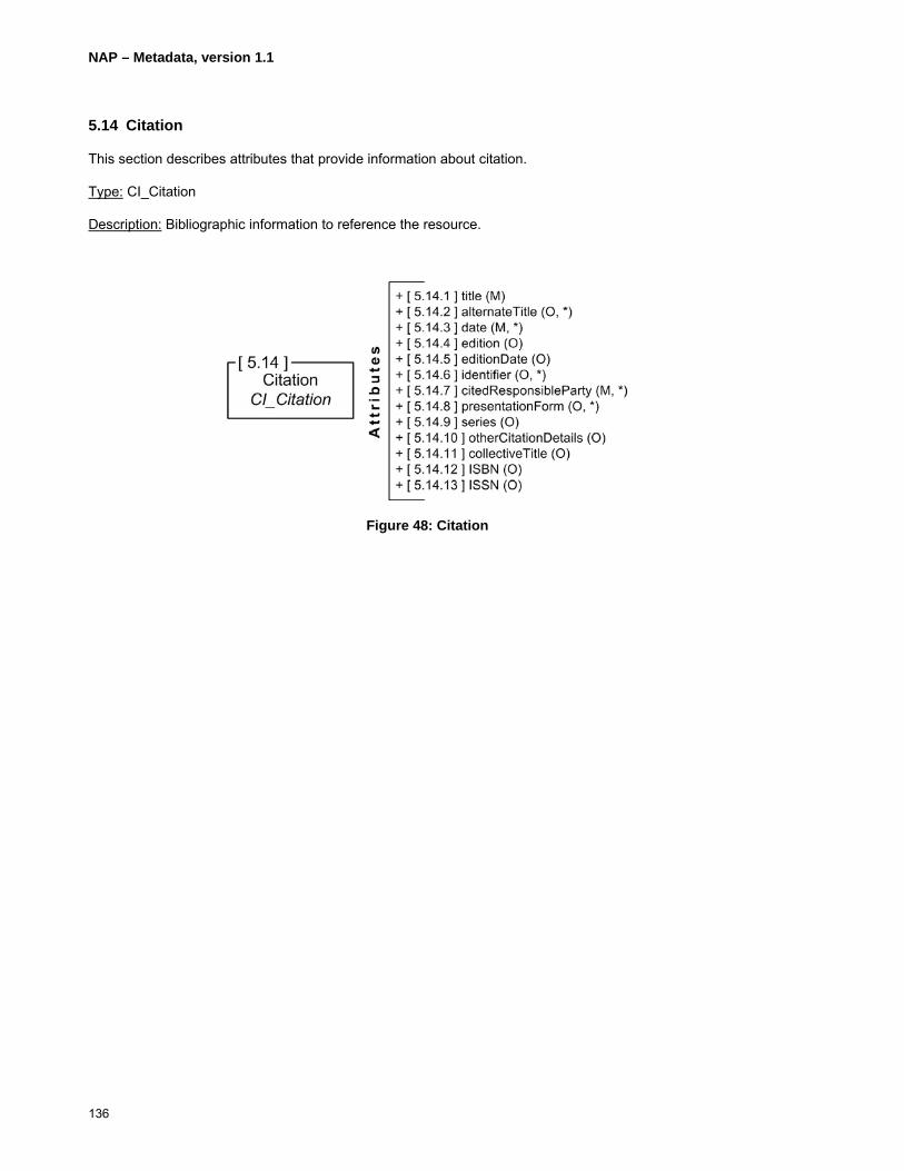
NAP – Metadata, version 1.1
136
5.14 Citation
This section describes attributes that provide information about citation.
Type: CI_Citation
Description: Bibliographic information to reference the resource.
Figure 48: Citation
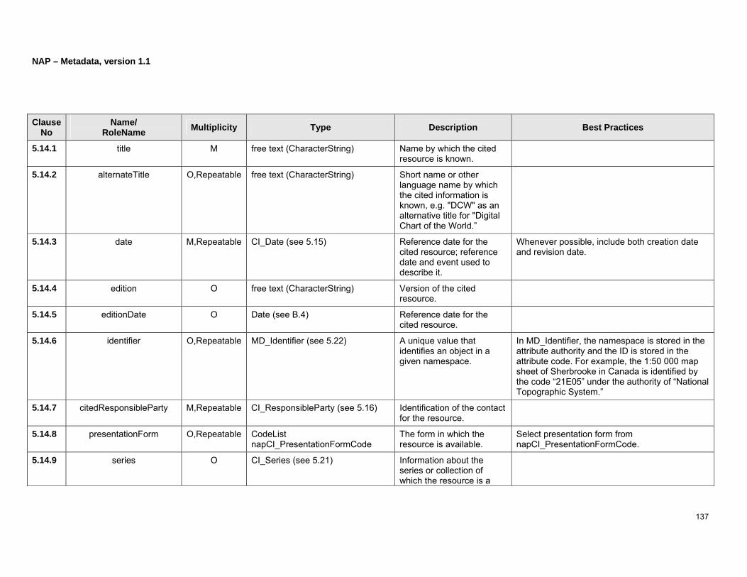
NAP – Metadata, version 1.1
137
Clause No
Name/ RoleName Multiplicity Type Description Best Practices
5.14.1 title M free text (CharacterString) Name by which the cited resource is known.
5.14.2 alternateTitle O,Repeatable free text (CharacterString) Short name or other language name by which the cited information is known, e.g. "DCW" as an alternative title for "Digital Chart of the World.”
5.14.3 date M,Repeatable CI_Date (see 5.15) Reference date for the cited resource; reference date and event used to describe it.
Whenever possible, include both creation date and revision date.
5.14.4 edition O free text (CharacterString) Version of the cited resource.
5.14.5 editionDate O Date (see B.4) Reference date for the cited resource.
5.14.6 identifier O,Repeatable MD_Identifier (see 5.22) A unique value that identifies an object in a given namespace.
In MD_Identifier, the namespace is stored in the attribute authority and the ID is stored in the attribute code. For example, the 1:50 000 map sheet of Sherbrooke in Canada is identified by the code “21E05” under the authority of “National Topographic System.”
5.14.7 citedResponsibleParty M,Repeatable CI_ResponsibleParty (see 5.16) Identification of the contact for the resource.
5.14.8 presentationForm O,Repeatable CodeList napCI_PresentationFormCode
The form in which the resource is available.
Select presentation form from napCI_PresentationFormCode.
5.14.9 series O CI_Series (see 5.21) Information about the series or collection of which the resource is a

NAP – Metadata, version 1.1
138
part.
5.14.10 otherCitationDetails O free text (CharacterString) Other information to complete a citation.
5.14.11 collectiveTitle O free text (CharacterString) Information about the combined resource of which the dataset is a part. The description may include information on other volumes which are also available.
5.14.12 ISBN O free text (CharacterString) The international standard book number (ISBN) assigned by an ISBN authority to a publication such as a book, a pamphlet, an educational kit, a microform, a CD-ROM or another digital or electronic publication.
5.14.13 ISSN O free text (CharacterString) The international standard serial number (ISSN) assigned by an ISSN authority to a serial publication, such as a periodical, a newspaper, an annual, a journal or a monographic series.

NAP – Metadata, version 1.1
139
(Page intentionally left blank)
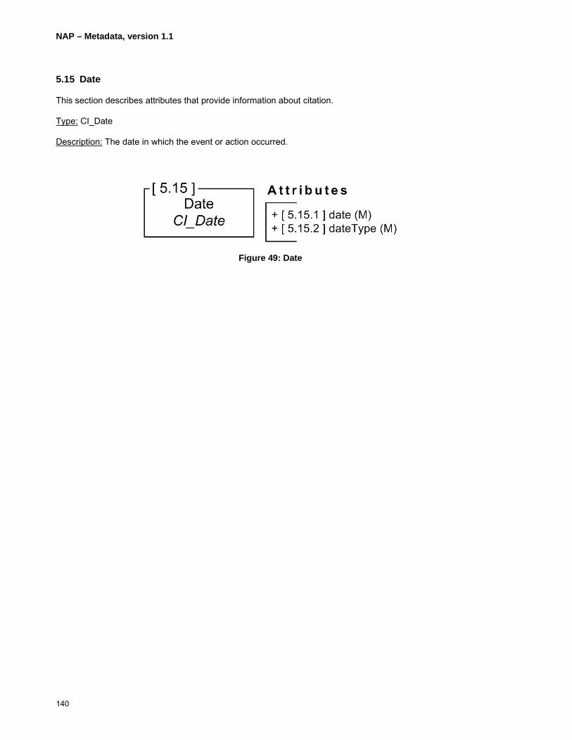
NAP – Metadata, version 1.1
140
5.15 Date
This section describes attributes that provide information about citation.
Type: CI_Date
Description: The date in which the event or action occurred.
Figure 49: Date
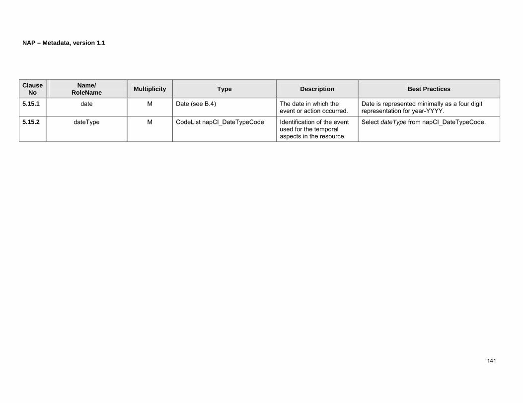
NAP – Metadata, version 1.1
141
Clause No
Name/ RoleName Multiplicity Type Description Best Practices
5.15.1 date M Date (see B.4) The date in which the event or action occurred.
Date is represented minimally as a four digit representation for year-YYYY.
5.15.2 dateType M CodeList napCI_DateTypeCode Identification of the event used for the temporal aspects in the resource.
Select dateType from napCI_DateTypeCode.

NAP – Metadata, version 1.1
142
5.16 Responsible Party
This section describes attributes that provide information about the responsible party.
Type: CI_ResponsibleParty
Description: The identification of those responsible for the resource and the party’s role in the resource.
Figure 50: Responsible party
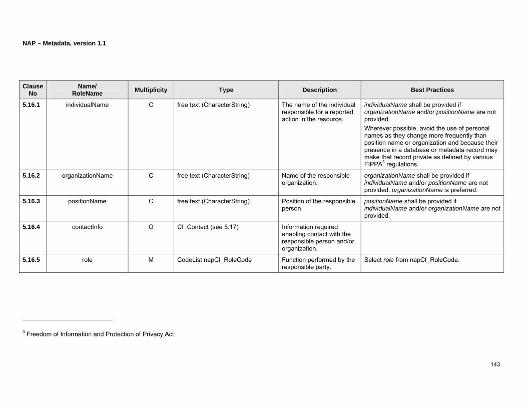
NAP – Metadata, version 1.1
143
Clause No
Name/ RoleName Multiplicity Type Description Best Practices
5.16.1 individualName C free text (CharacterString) The name of the individual responsible for a reported action in the resource.
individualName shall be provided if organizationName and/or positionName are not provided. Wherever possible, avoid the use of personal names as they change more frequently than position name or organization and because their presence in a database or metadata record may make that record private as defined by various FIPPA3 regulations.
5.16.2 organizationName C free text (CharacterString) Name of the responsible organization.
organizationName shall be provided if individualName and/or positionName are not provided. organizationName is preferred.
5.16.3 positionName C free text (CharacterString) Position of the responsible person.
positionName shall be provided if individualName and/or organizationName are not provided.
5.16.4 contactInfo O CI_Contact (see 5.17) Information required enabling contact with the responsible person and/or organization.
5.16.5 role M CodeList napCI_RoleCode Function performed by the responsible party.
Select role from napCI_RoleCode.
3 Freedom of Information and Protection of Privacy Act

NAP – Metadata, version 1.1
144
5.17 Contact
This section describes attributes that provide information about contact.
Type: CI_Contact
Description: Information which assists one to contact an individual or organization.
BP: One of phone, address, or onlineResource shall be provided.
Figure 51: Contact

NAP – Metadata, version 1.1
145
Clause No
Name/ RoleName Multiplicity Type Description Best Practices
5.17.1 phone O CI_Telephone (see 5.18) Telephone numbers to contact the organization or individual.
5.17.2 address O CI_Address (see 5.19) Physical and email address to contact the organization or individual.
5.17.3 onlineResource O CI_OnlineResource (see 5.20) Information about Internet hosted resources: availability; URL; protocol used; resource name; resource description, and resource function.
5.17.4 hoursOfService O free text (CharacterString) Time period (including time zone) when individuals can contact the organization or individual.
According to the ISO8601 representation of time-intervals by start and end time, hours of service is composed of a start and an end time in the form of: <startTime></><endTime> The start and end time representation conforms to ISO8601 extended format. In this format, hours are depicted by two digits <hh> ranging from “00” to “24”, minutes by two digits <mm> ranging from “00” to “59”, and seconds by two digits <mm> ranging from “00” to “60.” The basic format for local time is as follows: a) hour, minute, and second:
<hh><:><mm><:><ss> (e.g. 13:30:00); b) hour and minute:
<hh><:><mm> (e.g. 13:30); c) hour:
<hh> (e.g. 13).

NAP – Metadata, version 1.1
146
The character “Z” could be added at the end of the time representation if it needs to designate time in Coordinated Universal Time (UTC), e.g. 13:30Z. However if it needs to show the difference between local time and UTC, one the following could be added at the end of the time representation:
a) local time ahead of or equal to UTC: <+><hh><:><mm> (e.g. 13:30+05:00);
b) local time behind of or equal to UTC: <-><hh><:><mm> (e.g. 13:30-05:00).
5.17.5 contactInstructions O free text (CharacterString) Supplemental instructions on how or when to contact the individual or organization.

NAP – Metadata, version 1.1
147
(Page intentionally left blank)

NAP – Metadata, version 1.1
148
5.18 Telephone
This section describes attributes that provide information about telephone number.
Type: CI_Telephone
Description: Information on the telephone numbers used to contact the responsible individual or organization.
BP: Voice or Facsimile is required.
Figure 52: Telephone

NAP – Metadata, version 1.1
149
Clause No
Name/ RoleName Multiplicity Type Description Best Practices
5.18.1 voice O,Repeatable free text (CharacterString) Telephone number of an organization or individual.
The structure of the phone number is: <phoneType><;><blank space> <countryCode><blank space> <(><areaCode><)><localNumber> The phoneType values are either “voice” or “TDD/TTY.” e.g. voice; 1 (819) 5645600
5.18.2 facsimile O,Repeatable free text (CharacterString) Facsimile telephone number of an organization or individual.
The structure of the facsimile number is: <countryCode><blank space> <(><areaCode><)><localNumber> e.g. 1 (819) 5645698
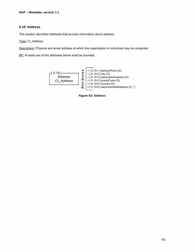
NAP – Metadata, version 1.1
150
5.19 Address
This section describes attributes that provide information about address.
Type: CI_Address
Description: Physical and email address at which the organization or individual may be contacted.
BP: At least one of the attributes below shall be provided.
Figure 53: Address

NAP – Metadata, version 1.1
151
Clause No
Name/ RoleName Multiplicity Type Description Best Practices
5.19.1 deliveryPoint O free text (CharacterString)
Address line for the location. The delivery point is described according to one of the following: a) <addressType><;><blank space><street
number><;><blank space><street name><;><blank space><floor ID><;><blank space><room/suite ID>
b) <addressType><;><blank space><box number><;><blank space><post office name>
The addressType is either “postal” or “physical.” For the case b), it shall be “postal.” Information not available or not applicable is left blank. For example, “physical; 2144; King West; ; 010” consists of a physical address of 2144 King West street with no floor information, and a room/suite ID of 010.
5.19.2 city O free text (CharacterString)
City of the address.
5.19.3 administrativeArea O free text (CharacterString)
State or province of the address. Lists of states and provinces are available at: a) United States: United States Post Service web page
at http://www.usps.com/ncsc/lookups/usps_abbreviations.htm
b) Canada: Post Canada – Canadian Adressing Guide at http://www.canadapost.ca/business/offerings/addressing_guide/can/province-e.asp
5.19.4 postalCode O free text (CharacterString)
administrative spatial code which assists mail and parcel delivery.
The postal code format should follow the standard structure of the country. For instance, the format in the U.S.is: <NNNNN>{<-><NNNN>} The format in Canada is:
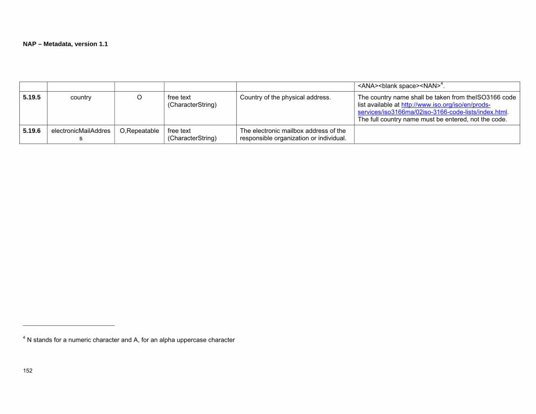
NAP – Metadata, version 1.1
152
<ANA><blank space><NAN>4.
5.19.5 country O free text (CharacterString)
Country of the physical address. The country name shall be taken from theISO3166 code list available at http://www.iso.org/iso/en/prods-services/iso3166ma/02iso-3166-code-lists/index.html. The full country name must be entered, not the code.
5.19.6 electronicMailAddress
O,Repeatable free text (CharacterString)
The electronic mailbox address of the responsible organization or individual.
4 N stands for a numeric character and A, for an alpha uppercase character

NAP – Metadata, version 1.1
153
(Page intentionally left blank)
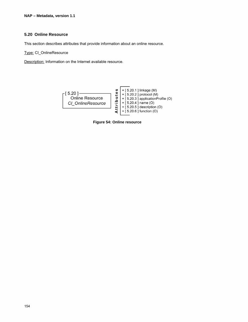
NAP – Metadata, version 1.1
154
5.20 Online Resource
This section describes attributes that provide information about an online resource.
Type: CI_OnlineResource
Description: Information on the Internet available resource.
Figure 54: Online resource

NAP – Metadata, version 1.1
155
Clause No
Name/ RoleName Multiplicity Type Description Best Practices
5.20.1 linkage M URL (see B.26) Internet location (address) for on-line access which uses a Uniform Resource Locator address or similar addressing scheme such as www.isotc211.org or ftp.isotc211.org .
5.20.2 protocol M free text (CharacterString) The connection protocol to be used such as http, ftp, etc.
The protocol should be taken from an official controlled list such as the Official Internet Protocol Standards published on the Web at http://www.rfc-editor.org/rfcxx00.html or the Internet Assigned Numbers Authority (IANA) at http://www.iana.org/numbers.html.
5.20.3 applicationProfile O free text (CharacterString) Name of an application profile that can be used with the online resource.
5.20.4 name O free text (CharacterString) Name of the utility that provides the resource sought.
5.20.5 description O free text (CharacterString) Description of the utility that provides the resource sought.
5.20.6 function O CodeList napCI_OnlineFunctionCode
Code for function performed by the online resource.
Select function from napCI_OnlineFunctionCode.

NAP – Metadata, version 1.1
156
5.21 Series
This section describes attributes that provide information about series.
Type: CI_Series
Description: Information about a Series publication or dataset aggregation.
BP: For reference to a parent record, use clause 5.2.4. For clarification on the use of hierarchy levels, refer to Appendix D.
Figure 55: Series

NAP – Metadata, version 1.1
157
Clause No
Name/ RoleName Multiplicity Type Description Best Practices
5.21.1 name O free text (CharacterString) Name of the publication series or aggregate dataset of which the referenced dataset is a part.
name shall be provided if issueIdentification is not provided.
5.21.2 issueIdentification O free text (CharacterString) Identification of the series’ issue information.
issueIdentification shall be provided if name is not provided.
5.21.3 page O free text (CharacterString) Identification of the articles’ page number(s).

NAP – Metadata, version 1.1
158
5.22 Identifier
This section describes attributes that provide information about identification.
Type: MD_Identifier
Description: Information about the unique identification of an object.
BP: The namespace is stored in the attribute authority and the ID is stored in the attribute code. For example, the 1:50 000 map sheet of Sherbrooke in Canada is identified by the code “21E05” under the authority of “National Topographic System."
Figure 56: Metadata identifier
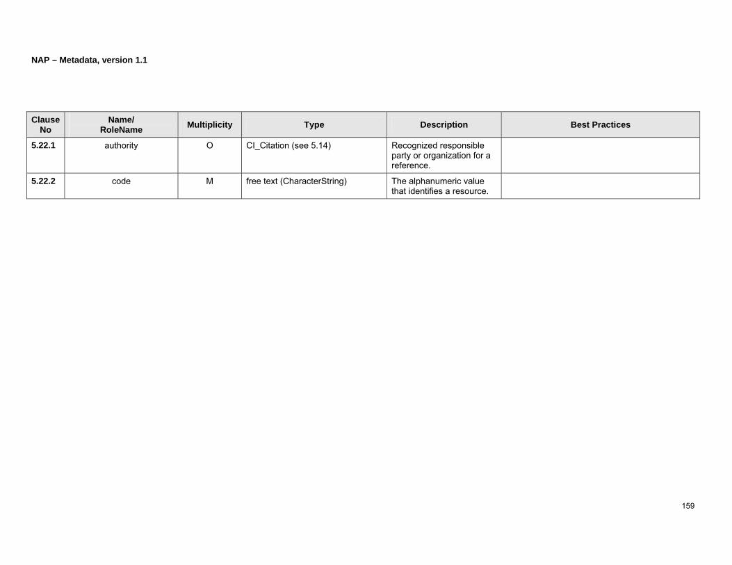
NAP – Metadata, version 1.1
159
Clause No
Name/ RoleName Multiplicity Type Description Best Practices
5.22.1 authority O CI_Citation (see 5.14) Recognized responsible party or organization for a reference.
5.22.2 code M free text (CharacterString) The alphanumeric value that identifies a resource.

NAP – Metadata, version 1.1
160
6 Cultural and Linguistic Adaptability
NAP – Metadata supports cultural and linguistic adaptability. It means that metadata is reported according to identified languages to serve cultures, application areas, professions, etc. Accordingly, three mechanisms are recognized in this profile:
1) Metadata language and CharacterSet;
2) Locale and free text attributes; and
3) Metadata element and code list register.
In this profile, there are four possibilities to identify languages and character sets:
1) the attributes language (see 5.2.2) and characterSet (see 5.2.2) in metadata record information;
2) the attribute locale (see 5.2.11) in metadata record information;
3) the attributes language (see 5.3.1.9) and characterSet (see 5.3.1.10) in data identification; and
4) the attribute language in feature catalogue description (see 5.9.1.2).
6.1 Metadata language and CharacterSet
Metadata elements are primarily reported in a specific language and an encoding character set that are identified in the attributes language (see 5.2.2) and CharacterSet (see 5.2.3) respectively, both at the metadata root level – i.e. Metadata Record Information (MD_Metadata). In this profile, the language identification is composed of a language identifier agreeing with ISO639-2/T three letter terminology code and a country identifier agreeing with ISO3166-1 three letter code separated by a semicolon (“;”) and a blank space character is used in this profile. The language code is in lowercase whereas the country code is in uppercase (e.g. “fra; CAN”). Any free text metadata element reported in that language uses the CharacterString data type as defined in ISO/TS19103:2005.
6.2 Locale and free text attributes
Metadata may need to be reported in various languages. This is the case in Canada, which has two official languages. For this purpose, this profile allows the representation of free text metadata in other languages. As such, the primary language used for metadata description is identified with the attributes language (see 5.2.2) and characterSet (see 5.2.3) respectively of the Metadata Record Information and any additional languages are identified in the attribute locale (see 5.2.11) of the Metadata Record Information. The attribute locale is documented in conformity with the PT_Locale type as defined in ISO19139:2007 and depicted in Figure 57.
Figure 57: Locale

NAP – Metadata, version 1.1
161
Here, the attribute language is provided according to ISO639-2/T three letter terminology codes in lowercase. The attribute country is provided according to ISO3166-1 three letter codes in uppercase.
A free text metadata can be reported within any declared languages. It must use either a LocalizedCharacterString or a PT_FreeText both subtypes of CharacterString as defined in ISO19139:2007 (Figure 58). A Localized Character String is a free text description that refers to one language (Figure 59) declared in the attribute locale of the metadata record information whereas PT_FreeText is a free text description in one or multiple languages declared in the attribute locale of the metadata record information (i.e. it aggregates at least one Localized Character String).
Figure 58: CharacterString, LocalisedCharacterString, and FreeText
Figure 59: LocalisedCharacterString
Therefore, CharacterString, LocalizedCharacterString, or PT_FreeText can be used to report free text metadata attributes.
Consequently, the following rules apply when using CharacterString, LocalisedCharacterString, and PT_FreeText:
1) CharacterString shall be used when
• a free text metadata attribute is reported in the primary metadata language and character set (attribute language and characterSet of MD_Metadata); or
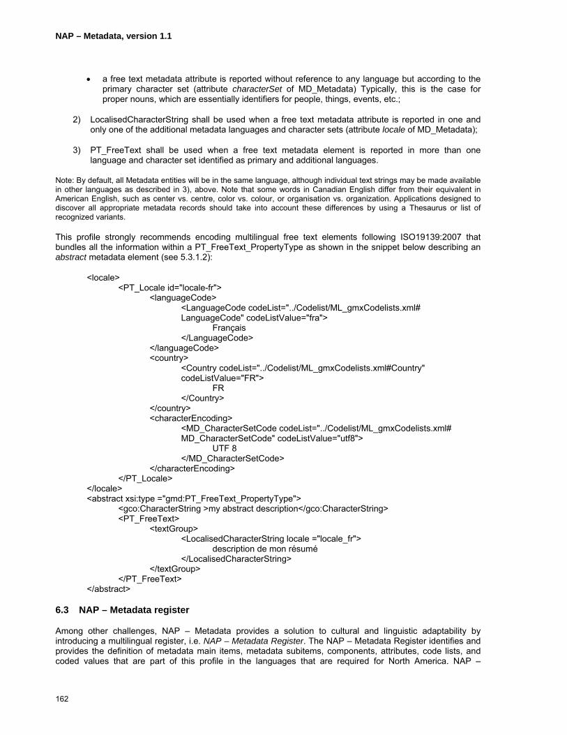
NAP – Metadata, version 1.1
162
• a free text metadata attribute is reported without reference to any language but according to the primary character set (attribute characterSet of MD_Metadata) Typically, this is the case for proper nouns, which are essentially identifiers for people, things, events, etc.;
2) LocalisedCharacterString shall be used when a free text metadata attribute is reported in one and only one of the additional metadata languages and character sets (attribute locale of MD_Metadata);
3) PT_FreeText shall be used when a free text metadata element is reported in more than one language and character set identified as primary and additional languages.
Note: By default, all Metadata entities will be in the same language, although individual text strings may be made available in other languages as described in 3), above. Note that some words in Canadian English differ from their equivalent in American English, such as center vs. centre, color vs. colour, or organisation vs. organization. Applications designed to discover all appropriate metadata records should take into account these differences by using a Thesaurus or list of recognized variants.
This profile strongly recommends encoding multilingual free text elements following ISO19139:2007 that bundles all the information within a PT_FreeText_PropertyType as shown in the snippet below describing an abstract metadata element (see 5.3.1.2):
<locale> <PT_Locale id="locale-fr">
<languageCode> <LanguageCode codeList="../Codelist/ML_gmxCodelists.xml# LanguageCode" codeListValue="fra">
Français </LanguageCode>
</languageCode> <country>
<Country codeList="../Codelist/ML_gmxCodelists.xml#Country" codeListValue="FR">
FR </Country>
</country> <characterEncoding>
<MD_CharacterSetCode codeList="../Codelist/ML_gmxCodelists.xml# MD_CharacterSetCode" codeListValue="utf8">
UTF 8 </MD_CharacterSetCode>
</characterEncoding> </PT_Locale>
</locale> <abstract xsi:type ="gmd:PT_FreeText_PropertyType">
<gco:CharacterString >my abstract description</gco:CharacterString> <PT_FreeText>
<textGroup> <LocalisedCharacterString locale ="locale_fr">
description de mon résumé </LocalisedCharacterString>
</textGroup> </PT_FreeText>
</abstract>
6.3 NAP – Metadata register
Among other challenges, NAP – Metadata provides a solution to cultural and linguistic adaptability by introducing a multilingual register, i.e. NAP – Metadata Register. The NAP – Metadata Register identifies and provides the definition of metadata main items, metadata subitems, components, attributes, code lists, and coded values that are part of this profile in the languages that are required for North America. NAP –

NAP – Metadata, version 1.1
163
Metadata Register supports English and French and may be extended as needed to support other languages, such as Spanish, Portuguese, and native North American languages, including support for additional alphabets needed for some native North American languages. In addition, code lists and their values that are referred in this clause may evolve and as such are not detailed in this document. By managing those in a register found at http://www.fgdc.gov/north-american-profile/register or http://www.geoconnections.org/ NAPMeta/register, it will not affect this profile. The NAP – Metadata Register is ISO19135:2005 compliant.
The following apply to the NAP – Metadata register:
• name: North American Profile of ISO19115:2003 Metadata Register
• Uniform resource identifier (URI): http://www.fgdc.gov/north-american-profile/register http://www.geoconnections.org/NAPMeta/register
• Operating language: English
7 Code Lists
ISO 19115:2003 and the NAP – Metadata use code lists to standardized textual metadata elements. A code list is an open enumeration of values which permits extending or adding codes as needed. NAP – Metadata uses ISO 19115:2003 code lists, extends some of them, and develops new ones to standardize some free text metadata elements. Annex D provides a list of the NAP – Metadata code lists. In order to distinguish NAP – Metadata code lists to ISO19115:2003 code lists and avoid confusion, all NAP – Metadata code lists are prefixed with ”nap”, i.e. “napCI_”, “napDQ_”, “napDS_”, and “napMD_”. Figure 60 shows examples of an extended code list with codes shown in bold type, napCI_DateTypeCode, and a new code list for a text data type, napMD_FileFormatCode.
«CodeList» napCI_DateTypeCode
«CodeList» napMD_FileFormatCode
+ creation + publication + revision + notAvailable + inForce + adopted + deprecated + superseded
+ bil + bmp + bsq + bzip2 + cdr + cgm + cover + csv + dbf + dgn + doc + dwg + dxf + …
Figure 60: Examples of NAP – Metadata code list
An ISO19115 extended code list will be presented in an ISO19139 compliant XML document using the corresponding ISO19139 tag name with the reference to the appropriate NAP – Metadata register codelist within the XML attribute codeList, example:
NAP – Metadata, version 1.1
164
<codeListValue type="gmd:CI_DateTypeCode" codeList="./napMetadataRegister.xml#ICxxxx">deprecated</codeListValue>
When using a new NAP – Metadata code list, the instance document must introduce its definition in the substitution group of CharacterString, example:
<xs:element name="napMD_FileFormatCode" type="gco:CodeListValue_Type" substitutionGroup="gco:CharacterString"/>
CharacterString metadata items are then allowed to use such a code list to represent its content.
NAP –Metadata code lists shall be used to claim compliance with this profile.
It is not the intention of this document to list all code lists and coded values that are needed for NAP – Metadata. The code lists and coded values are managed as part of and made available from the NAP – Metadata Register that is introduced in Clause 7. As such, code lists and coded values are available in the various languages handled by the register.
8 Extending the Profile
User communities may find it valuable to create extensions to this profile. While the specific extensions in any profile will not be interoperable with the standard, the core and reused elements from this profile, and from the ISO 19115 standard from which it is derived, will remain interoperable.
However before developing NAP – Metadata extensions, the following notices are given:
• Before developing any extension to this profile, it is important to recognize that these extensions will not be interoperable outside of the specific community for which they will be developed;
• Therefore before initiating any extension development, a complete and careful study of the “Metadata Content” section of this profile along with the NAP-Metadata Register should be conducted in order to identify appropriate ways and coded values to document metadata. Extensions might not be required if existing metadata items and coded values meet the requirements;
• The review of any available formal NAP – Metadata extensions should also be considered before developing others as they might fulfil the needs and be reused.
Although NAP – Metadata does not provide explicit instructions for its extension process, it is still possible to extend this profile. To that end, the Metadata extension methodology from Annex F of ISO19115:2003, Geographic information – Metadata along with ISO19106:2004, Geographic Information – Profiles should be followed.

NAP – Metadata, version 1.1
165
Bibliography
ISO, 1998. ISO639-2:1998, Codes for the representation of names of languages - Part 2: alpha-3 code (International standardization Organization).
ISO, 2006. ISO3166-1:2006, Codes for the representation of names of countries and their subdivisions - Part 1: Country codes (International standardization Organization).
ISO, 2002. ISO/TS19101:2005 Geographic information – Reference model (International standardization Organization).
ISO, 2005. ISO/TS19103:2005 Geographic information - Conceptual schema language (International standardization Organization).
ISO, 2004. ISO19106:2004 Geographic Information – Profiles (International standardization Organization).
ISO, 2005. ISO/FDIS19111rev. Geographic information – Spatial referencing by coordinates (International standardization Organization).
ISO, 2003. ISO19115:2003 Geographic information – Metadata (International standardization Organization).
ISO, 2006. ISO19115:2003 Geographic information – Metadata, Technical corrigendum 1 (International standardization Organization).
ISO, 2005. ISO19118:2005 Geographic information – Encoding (International standardization Organization).
ISO, 2005. ISO19119:2005 Geographic information – Services (International standardization Organization).
ISO, 2006. ISO19119:2005 DAM 1 Geographic information – Services (International standardization Organization).
ISO, 2005. ISO/TS19127:2005 Geographic information – Geodetic codes and parameters (International standardization Organization).
ISO, 2005. ISO/TS19128:2005 Geographic information – Web map server interface (International standardization Organization).
ISO, 2006. ISO/DIS19132 Geographic information – Location Based Services - Reference model (International standardization Organization).
ISO, 2005. ISO19135:2005 Geographic information – Procedures for item registration (International standardization Organization).
ISO, 2005. ISO/DIS19136 Geographic information – Geography markup language (International standardization Organization).
ISO, 2007. ISO/TS19139:2007 Geographic information – Metadata - XML schema implementation (International standardization Organization).
Open geospatial Consortium, 2005. OpenGIS® Web Services Common Specification, OGC 05-008.

NAP – Metadata, version 1.1
166
Annex A
Metadata Schemas
(normative)
A.1 NAP – Metadata UML diagram differences from ISO19115 UML diagrams
This annex provides normative diagrams describing metadata element of this profile in the Unified Modelling Language (UML). These diagrams are based on those of ISO19115:2003 Geographic information – Metadata. They provide “views,” which are portions of the complete model, that defines a metadata section (UML package) of related entities, elements, data types, and code lists. Throughout the following models, entities may have mandatory and/or optional elements and associations. In some cases, optional entities may have mandatory elements; those elements become mandatory only if the optional element is used. Throughout the diagrams, classes and relationships shown in light grey indicate that are not used in this profile and notes in light grey entitled “NAP – Metadata” highlight attribute changes from ISO19115:2003 Geographic information – Metadata to NAP – Metadata.
The UML notations used in this profile are described in the Figure 61.
Figure 61: UML notation
An association describes a relationship between two or more classes. Three types of association are possible: association, aggregation and composition. A simple association represents a general relationship between two classes; aggregation, and composition associations consist of soft and strong part-whole relationships respectively between two classes. An association is typically bi-directional but can specify a specific direction with an arrow end. A navigable association supplies a “role name” that is appropriate for the role of the target object in relation to the source object. Accordingly, a bi-directional association has a role name at both ends. The representation of role name and multiplicity is illustrated in Figure 62.
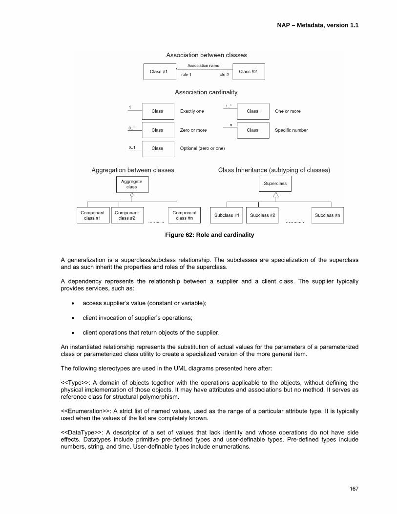
NAP – Metadata, version 1.1
167
Figure 62: Role and cardinality
A generalization is a superclass/subclass relationship. The subclasses are specialization of the superclass and as such inherit the properties and roles of the superclass.
A dependency represents the relationship between a supplier and a client class. The supplier typically provides services, such as:
• access supplier’s value (constant or variable);
• client invocation of supplier’s operations;
• client operations that return objects of the supplier.
An instantiated relationship represents the substitution of actual values for the parameters of a parameterized class or parameterized class utility to create a specialized version of the more general item.
The following stereotypes are used in the UML diagrams presented here after:
<<Type>>: A domain of objects together with the operations applicable to the objects, without defining the physical implementation of those objects. It may have attributes and associations but no method. It serves as reference class for structural polymorphism.
<<Enumeration>>: A strict list of named values, used as the range of a particular attribute type. It is typically used when the values of the list are completely known.
<<DataType>>: A descriptor of a set of values that lack identity and whose operations do not have side effects. Datatypes include primitive pre-defined types and user-definable types. Pre-defined types include numbers, string, and time. User-definable types include enumerations.
NAP – Metadata, version 1.1
168
<<CodeList>>: An open and flexible enumeration expressing a long list of potential values. It is typically used when only likely values of the list are known.

NAP – Metadata, version 1.1
169
A.2 Metadata Package UML Diagrams
A.2.1 Metadata Record Information
Conditional statements:language: documented if not defined by the encoding standardcharacterSet: documented if ISO 10646-1 not used and not defined by the encoding standardparentIdentifier: documented if the hierarchy of a higher level exists
MD_SpatialRepresentation(from Spatial representation information)
<<Abstract>>
MD_ApplicationSchemaInformation(from Application schema information)
MD_PortrayalCatalogueReference(from Portrayal catalogue information)
MD_MetadataExtensionInformation(from Metadata extension information)
MD_ContentInformation(from Content information)
<<Abstract>>
MD_ReferenceSystem(from Reference system information)
DQ_DataQuality(from Data quality information)
MD_Distribution(from Distribution information)
MD_MaintenanceInformation(from Maintenance information)MD_Metadata
+ fileIdentifier : CharacterString+ language : CharacterString+ characterSet : MD_CharacterSetCode = "utf8"+ parentIdentifier[0..1] : CharacterString+ hierarchyLevel[1..*] : MD_ScopeCode = "dataset"+ hierarchyLevelName[0..*] : CharacterString+ contact[1..*] : CI_ResponsibleParty+ dateStamp : Date+ metadataStandardName : CharacterString = "NAP-Metadata"+ metadataStandardVersion[0..1] : CharacterString+ dataSetURI[0..1] : CharacterString+ locale[0..*] : PT_Locale
0..*+spatialRepresentationInfo 0..*
0..*+applicationSchemaInfo 0..*
0..*+portrayalCatalogueInfo
0..*
0..1
+metadataMaintenance
0..1
0..* +metadataExtensionInfo0..*
0..*
+contentInfo
0..*
0..*+referenceSystemInfo 0..*0..*
+dataQualityInfo
0..*
0..1
+distributionInfo
0..1
MD_Constraints(from Constraint information)
0..*
+metadataConstraints
0..*
MD_Identification(from Identification information)
<<Abstract>>
0..*+resourceMaintenance0..*
1..*
+identificationInfo
1..*
0..* +resourceConstraints0..*
NAP - Metadata:+ fileIdentifier: Mandatory+ language: mandatory, composed of a language code (ISO639-2/T) and an alpha3 country code (ISO3166-1)+ characterSet: "utf8" mandatory+ hierarchyLevel: mandatory+ hierarchyLevelName: not used; it duplicates information provided in DataIdentification.citation.title+ metadataStandardName: "NAP - Metadata" mandatory+ locale: documented when more than one language is used in free text descriptions.
NAP - Metadata:{ (identificationInfo.spatialRepresentationType = "vector") or(identificationInfo.spatialRepresentationType = "grid") or(identificationInfo.spatialRepresentationType = "tin")implies count referenceSystemInfo >= 1) }
Figure 63: Metadata record information
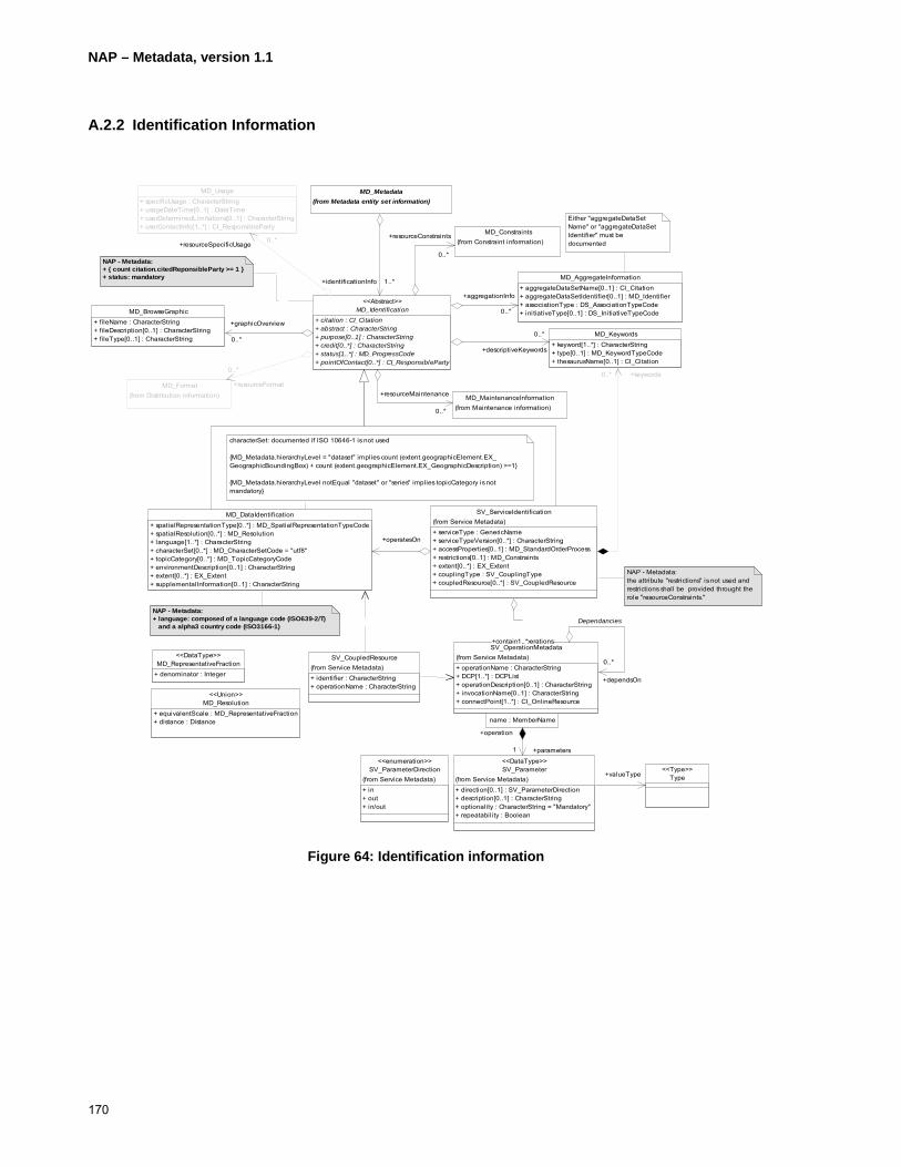
NAP – Metadata, version 1.1
170
A.2.2 Identification Information
MD_Resolution+ equivalentScale : MD_RepresentativeFraction+ distance : Distance
<<Union>>
MD_RepresentativeFraction+ denominator : Integer
<<DataType>>
characterSet: documented if ISO 10646-1 is not used
{MD_Metadata.hierarchyLevel = "dataset" impl ies count (extent.geographicElement.EX_GeographicBoundingBox) + count (extent.geographicElement.EX_GeographicDescription) >=1}
{MD_Metadata.hierarchyLevel notEqual "dataset" or "series" implies topicCategory is not mandatory}
Either "aggregateDataSetName" or "aggregateDataSetIdentifier" must be documented
NAP - Metadata:+ { count citation.citedReponsibleParty >= 1 }+ status: mandatory
NAP - Metadata:+ language: composed of a language code (ISO639-2/T) and a alpha3 country code (ISO3166-1)
SV_CoupledResource
+ identi fier : CharacterString+ operationName : CharacterString
(from Service Metadata)
MD_Format(from Distribution information)
MD_Usage+ specificUsage : CharacterString+ usageDateTime[0..1] : DateTime+ userDeterminedLimitations[0..1] : CharacterString+ userContactInfo[1..*] : CI_ResponsibleParty
MD_MaintenanceInformation(from Maintenance information)
MD_Metadata(from Metadata entity set information)
MD_BrowseGraphic+ fileName : CharacterString+ fileDescription[0..1] : CharacterString+ fileType[0..1] : CharacterString
MD_AggregateInformation+ aggregateDataSetName[0..1] : CI_Citation+ aggregateDataSetIdentifier[0..1] : MD_Identifier+ associationType : DS_AssociationTypeCode+ ini tiativeType[0..1] : DS_InitiativeTypeCode
MD_Constraints(from Constraint information)
MD_Identification+ citation : CI_Citation+ abstract : CharacterString+ purpose[0..1] : CharacterString+ credit[0..*] : CharacterString+ status[1..*] : MD_ProgressCode+ pointOfContact[0..*] : CI_ResponsibleParty
<<Abstract>>
0..*
+resourceFormat
0..*
0..*+resourceSpecificUsage
0..*
0..*
+resourceMaintenance
0..*
1..*+identificationInfo 1..*
0..*
+graphicOverview
0..*
0..*
+aggregationInfo
0..*
0..*
+resourceConstraints
0..*
MD_DataIdentification+ spatialRepresentationType[0..*] : MD_SpatialRepresentationTypeCode+ spatialResolution[0..*] : MD_Resolution+ language[1..*] : CharacterString+ characterSet[0..*] : MD_CharacterSetCode = "utf8"+ topicCategory[0..*] : MD_TopicCategoryCode+ environmentDescription[0..1] : CharacterString+ extent[0..*] : EX_Extent+ supplementalInformation[0..1] : CharacterString
MD_Keywords+ keyword[1..*] : CharacterString+ type[0..1] : MD_KeywordTypeCode+ thesaurusName[0..1] : CI_Citation
0..*
+descriptiveKeywords
0..*
SV_ServiceIdentification
+ serviceType : GenericName+ serviceTypeVersion[0..*] : CharacterString+ accessProperties[0..1] : MD_StandardOrderProcess+ restrictions[0..1] : MD_Constraints+ extent[0..*] : EX_Extent+ couplingType : SV_CouplingType+ coupledResource[0..*] : SV_CoupledResource
(from Service Metadata)
+operatesOn
0..* +keywords0..*
SV_OperationMetadata
+ operationName : CharacterString+ DCP[1..*] : DCPList+ operationDescription[0..1] : CharacterString+ invocationName[0..1] : CharacterString+ connectPoint[1..*] : CI_OnlineResource
(from Service Metadata)
1..*+containsOperations1..*
0..*
+dependsOn
0..*
Dependancies
SV_Parameter
+ direction[0..1] : SV_ParameterDirection+ description[0..1] : CharacterString+ optionality : CharacterString = "Mandatory"+ repeatabili ty : Boolean
(from Service Metadata)
<<DataType>>
name : MemberName
1
+operation
name : MemberName
+parameters1
Type<<Type>>
+valueType
NAP - Metadata:the attribute "restrictions" is not used and restrictions shall be provided throught the role "resourceConstraints."
SV_ParameterDirection
+ in+ out+ in/out
(from Service Metadata)
<<enumeration>>
Figure 64: Identification information

NAP – Metadata, version 1.1
171
A.2.3 Data Identification Information
characterSet: documented if ISO 10646-1 is not used
{MD_Metadata.hierarchyLevel = "dataset" implies count (extent.geographicElement.EX_GeographicBoundingBox) + count (extent.geographicElement.EX_GeographicDescription) >=1}
{MD_Metadata.hierarchyLevel notEqual "dataset" or "series" implies topicCategory is not mandatory}
NAP - Metadata:+ { count citation.citedReponsibleParty >= 1 }+ status: mandatory
NAP - Metadata:+ language: composed of a language code (ISO639-2/T) and an alpha3 country code (ISO3166-1)
MD_DataIdentification+ spatialRepresentationType[0..*] : MD_SpatialRepresentationTypeCode+ spatialResolution[0..*] : MD_Resolution+ language[1..*] : CharacterString+ characterSet[0..*] : MD_CharacterSetCode = "utf8"+ topicCategory[0..*] : MD_TopicCategoryCode+ environmentDescription[0..1] : CharacterString+ extent[0..*] : EX_Extent+ supplementalInformation[0..1] : CharacterString
MD_Format(from Distribution information)
MD_Metadata(from Metadata entity set information)
MD_Keywords+ keyword[1..*] : CharacterString+ type[0..1] : MD_KeywordTypeCode+ thesaurusName[0..1] : CI_Citation
MD_Identification+ citation : CI_Citation+ abstract : CharacterString+ purpose[0..1] : CharacterString+ credit[0..*] : CharacterString+ status[1..*] : MD_ProgressCode+ pointOfContact[0..*] : CI_ResponsibleParty
<<Abstract>>
0..*+resourceFormat 0..*
1..*+identificationInfo 1..*
0..*
+descriptive
0..*
Figure 65: Data identification information

NAP – Metadata, version 1.1
172
A.2.4 Service Identification Information
NAP - Metadata:+ { count citation.citedReponsibleParty >= 1 }+ status: mandatory
NAP - Metadata:the attribute "restrictions" is not used and restrictions shall be provided throught the role "resourceConstraints."
MD_Format(from Distribution information)
MD_Metadata(from Metadata entity set information)
MD_Constraints(from Constraint information)
MD_Identification+ citation : CI_Citation+ abstract : CharacterString+ purpose[0..1] : CharacterString+ credit[0..*] : CharacterString+ status[1..*] : MD_ProgressCode+ pointOfContact[0..*] : CI_ResponsibleParty
<<Abstract>>
0..*
+resourceFormat
0..*
1..*+identificationInfo 1..*
0..*
+resourceConstraints
0..*
MD_Keywords+ keyword[1..*] : CharacterString+ type[0..1] : MD_KeywordTypeCode+ thesaurusName[0..1] : CI_Citation
0..*
+descriptiveKeywords
0..*
SV_ServiceIdentification
+ serviceType : GenericName+ serviceTypeVersion[0..*] : CharacterString+ accessProperties[0..1] : MD_StandardOrderProcess+ restrictions[0..1] : MD_Constraints+ extent[0..*] : EX_Extent+ couplingType : SV_CouplingType+ coupledResource[0..*] : SV_CoupledResource
(from Service Metadata)
0..* +keywords0..*
SV_OperationMetadata
+ operationName : CharacterString+ DCP[1..*] : DCPList+ operationDescription[0..1] : CharacterString+ invocationName[0..1] : CharacterString+ connectPoint[1..*] : CI_OnlineResource
(from Service Metadata)
1..*+containsOperations 1..*
0..*
+dependsOn
0..*
Dependancies
SV_Parameter
+ direction[0..1] : SV_ParameterDirection+ description[0..1] : CharacterString+ optionali ty : CharacterString = "Mandatory"+ repeatabili ty : Boolean
(from Service Metadata)
<<DataType>>
name : MemberName
1
+operation
name : MemberName
+parameters1
Type<<Type>>+valueType
SV_CoupledResource
+ identifier : CharacterString+ operationName : CharacterString
(from Service Metadata)
Figure 66: Service identification information

NAP – Metadata, version 1.1
173
A.2.5 Constraint Information
MD_LegalConstraints+ accessConstraints[0..*] : MD_RestrictionCode+ useConstraints[0..*] : MD_RestrictionCode+ otherConstraints[0..*] : CharacterString
MD_SecurityConstraints+ classification : MD_ClassificationCode+ userNote[0..1] : CharacterString+ classificationSystem[0..1] : CharacterString+ handlingDescription[0..1] : CharacterString
MD_Identification(from Identi fication information)
<<Abstract>>
MD_Constraints+ useLimitation[0..*] : CharacterString
0..*+resourceConstraints 0..*
MD_Metadata(from Metadata entity set information)
0..* +metadataConstraints0..*
otherConstraints: documented if accessConstraints or useConstraints = "otherRestrictions"
NAP - Metadata:{count (self.useLimitation +self.accessConstraints + self.useConstraints + self.otherConstraints) > 0 }
NAP - Metadata:+ useLimitation: mandatory when MD_Constraints is used standalone
Figure 67: Constraint information
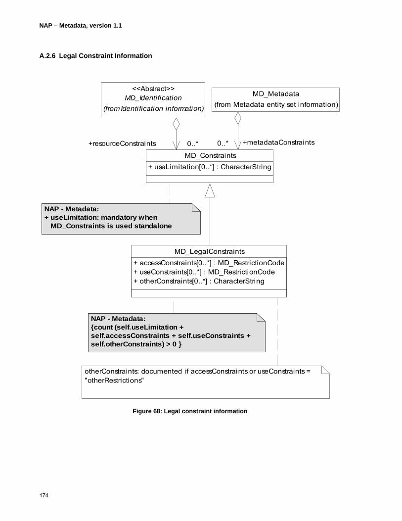
NAP – Metadata, version 1.1
174
A.2.6 Legal Constraint Information
MD_LegalConstraints+ accessConstraints[0..*] : MD_RestrictionCode+ useConstraints[0..*] : MD_RestrictionCode+ otherConstraints[0..*] : CharacterString
otherConstraints: documented if accessConstraints or useConstraints = "otherRestrictions"
NAP - Metadata:{count (self.useLimitation +self.accessConstraints + self.useConstraints + self.otherConstraints) > 0 }
NAP - Metadata:+ useLimitation: mandatory when MD_Constraints is used standalone
MD_Identification(from Identification information)
<<Abstract>>
MD_Constraints+ useLimitation[0..*] : CharacterString
0..*+resourceConstraints 0..*
MD_Metadata(from Metadata entity set information)
0..* +metadataConstraints0..*
Figure 68: Legal constraint information

NAP – Metadata, version 1.1
175
A.2.7 Data Quality Information
DQ_ConformanceResult+ specification : CI_Citation+ explanation : CharacterString+ pass : Boolean
DQ_QuantitativeResult+ valueType[0..1] : RecordType+ valueUnit : UnitOfMeasure+ errorStatistic[0..1] : CharacterString+ value[1..*] : Record
DQ_Scope+ level : MD_ScopeCode+ extent[0..1] : EX_Extent+ levelDescription[0..*] : MD_ScopeDescription
<<DataType>>
DQ_Result<<Abstract>>
"report" or "lineage" role is mandatory if scope.DQ_Scope.level = 'dataset'
"levelDescription" is mandatory if "level" notEqual 'dataset' or 'series'
MD_Metadata(from Metadata enti ty set information)
LI_Lineage
DQ_DataQuali ty+ scope : DQ_Scope
0..*+dataQuali tyInfo 0..*
0..1 +lineage0..1
DQ_Element+ nameOfMeasure[0..*] : CharacterString+ measureIdentification[0..1] : MD_Identifier+ measureDescription[0..1] : CharacterString+ evaluationMethodType[0..1] : DQ_EvaluationMethodTypeCode+ evaluationMethodDescription[0..1] : CharacterString+ evaluationProcedure[0..1] : CI_Citation+ dateTime[0..*] : DateTime+ result[1..2] : DQ_Result
<<Abstract>>
0..* +report0..*
MD_ScopeDescription
+ attributes : Set<GF_AttributeType>+ features : Set<GF_FeatureType>+ featureInstances : Set<GF_FeatureType>+ attributeInstances : Set<GF_AttributeType>+ dataset : CharacterString+ other : CharacterString
(from Maintenance information)
<<Union>>
Figure 69: Data quality information

NAP – Metadata, version 1.1
176
A.2.8 Lineage Information
If(count(source) + count(processStep) =0) and (DQ_DataQuality.scope.level = 'dataset' or 'series') then statement is mandatory
"source" role is mandatory if LI_Lineage.statement and "processStep" role are not documented
"processStep" role is mandatory if LI_Lineage.statement and "source" role are not documented
"description" is mandatory if "sourceExtent" is not documented
"sourceExtent" is mandatory if "description" is not documented
NAP - Metadata:{count (self.description + self.sourceExtent) > 0 } and {count (self.description + self.sourceCitation) > 0 }
DQ_DataQuality+ scope : DQ_Scope
LI_Lineage+ statement[0..1] : CharacterString
0..1+lineage 0..1
LI_ProcessStep+ description : CharacterString+ rationale[0..1] : CharacterString+ dateTime[0..1] : DateTime+ processor[0..*] : CI_ResponsibleParty
0..* +processStep0..*LI_Source
+ description[0..1] : CharacterString+ scaleDenominator[0..1] : MD_RepresentativeFraction+ sourceReferenceSystem[0..1] : MD_ReferenceSystem+ sourceCitation[0..1] : CI_Citation+ sourceExtent[0..*] : EX_Extent
0..*+source 0..*
0..*
0..* +sourceStep
0..*+source0..*
Figure 70: Lineage information

NAP – Metadata, version 1.1
177
A.2.9 Data Quality Classes and Subclasses
DQ_Completeness<<Abstract>>
DQ_LogicalConsistency<<Abstract>>
DQ_PositionalAccuracy<<Abstract>>
DQ_ThematicAccuracy<<Abstract>>
DQ_TemporalAccuracy<<Abstract>>
DQ_CompletenessCommission
DQ_CompletenessOmission
DQ_ConceptualConsistency
DQ_DomainConsistency
DQ_FormatConsistency
DQ_TopologicalConsistency
DQ_AbsoluteExternalPositionalAccuracy
DQ_GriddedDataPositionalAccuracy
DQ_RelativeInternalPositionalAccuracy
DQ_ThematicClassificationCorrectness
DQ_NonQuantitativeAttributeAccuracy
DQ_QuantitativeAttributeAccuracy
DQ_AccuracyOfATimeMeasurement
DQ_TemporalConsistency
LI_Lineage DQ_Element<<Abstract>>
DQ_DataQuality+ scope : DQ_Scope
0..1
+lineage
0..1 0..*
+report
0..*
DQ_TemporalValidity
Figure 71: Data quality classes and subclasses

NAP – Metadata, version 1.1
178
A.2.10 Maintenance Information
MD_Metadata(from Metadata entity set information)
MD_ScopeDescription+ attributes : Set<GF_AttributeType>+ features : Set<GF_FeatureType>+ featureInstances : Set<GF_FeatureType>+ attributeInstances : Set<GF_AttributeType>+ dataset : CharacterString+ other : CharacterString
<<Union>>
MD_MaintenanceInformation+ maintenanceAndUpdateFrequency : MD_MaintenanceFrequencyCode+ dateOfNextUpdate[0..1] : Date+ userDefinedMaintenanceFrequency[0..1] : TM_PeriodDuration+ updateScope[0..*] : MD_ScopeCode+ updateScopeDescription[0..*] : MD_ScopeDescription+ maintenanceNote[0..*] : CharacterString+ contact[0..*] : CI_ResponsibleParty
MD_Identification(from Identification information)
<<Abstract>>
0..* +resourceMaintenance0..*0..1+metadataMaintenance 0..1
1..*+identificationInfo 1..*
Each set of GF_AttributeType and GF_FeatureType is a set of instances of these
Figure 72: Maintenance information
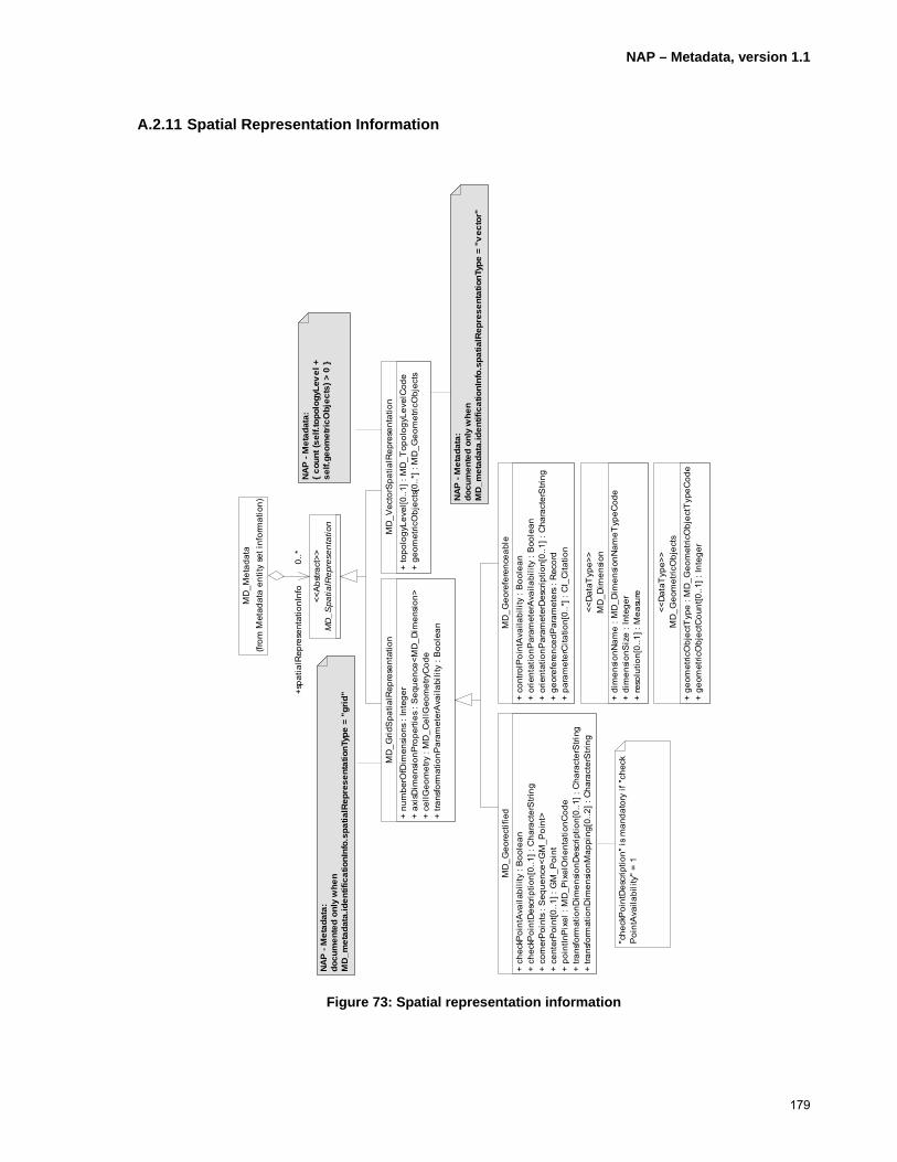
NAP – Metadata, version 1.1
179
A.2.11 Spatial Representation Information
Figure 73: Spatial representation information
MD
_Vec
torS
patia
lRep
rese
ntat
ion
+ to
polo
gyLe
vel[0
..1] :
MD
_Top
olog
yLev
elC
ode
+ ge
omet
ricO
bjec
ts[0
..*] :
MD
_Geo
met
ricO
bjec
ts
MD
_Grid
Spa
tialR
epre
sent
atio
n+
num
berO
fDim
ensi
ons
: Int
eger
+ ax
isD
imen
sion
Pro
perti
es :
Seq
uenc
e<M
D_D
imen
sion
>+
cellG
eom
etry
: M
D_C
ellG
eom
etry
Cod
e+
trans
form
atio
nPar
amet
erA
vaila
bilit
y : B
oole
an
MD
_Met
adat
a(fr
om M
etad
ata
entit
y se
t inf
orm
atio
n)
MD
_Spa
tialR
epre
sent
atio
n<<
Abs
tract
>>0..*
+spa
tialR
epre
sent
atio
nInf
o0.
.*
MD
_Geo
refe
renc
eabl
e+
cont
rolP
oint
Ava
ilabi
lity
: Boo
lean
+ or
ient
atio
nPar
amet
erA
vaila
bilit
y : B
oole
an+
orie
ntat
ionP
aram
eter
Des
crip
tion[
0..1
] : C
hara
cter
Stri
ng+
geor
efer
ence
dPar
amet
ers
: Rec
ord
+ pa
ram
eter
Cita
tion[
0..*
] : C
I_C
itatio
n
MD
_Dim
ensi
on+
dim
ensi
onN
ame
: MD
_Dim
ensi
onN
ameT
ypeC
ode
+ di
men
sion
Siz
e : I
nteg
er+
reso
lutio
n[0.
.1] :
Mea
sure
<<D
ataT
ype>
>
MD
_Geo
rect
ified
+ ch
eckP
oint
Ava
ilabi
lity
: Boo
lean
+ ch
eckP
oint
Des
crip
tion[
0..1
] : C
hara
cter
Stri
ng+
corn
erP
oint
s : S
eque
nce<
GM
_Poi
nt>
+ ce
nter
Poi
nt[0
..1] :
GM
_Poi
nt+
poin
tInP
ixel
: M
D_P
ixel
Orie
ntat
ionC
ode
+ tra
nsfo
rmat
ionD
imen
sion
Des
crip
tion[
0..1
] : C
hara
cter
Stri
ng+
trans
form
atio
nDim
ensi
onM
appi
ng[0
..2] :
Cha
ract
erS
tring
"che
ckP
oint
Des
crip
tion"
is m
anda
tory
if "
chec
kP
oint
Ava
ilabi
lity"
= 1
MD
_Geo
met
ricO
bjec
ts+
geom
etric
Obj
ectT
ype
: MD
_Geo
met
ricO
bjec
tTyp
eCod
e+
geom
etric
Obj
ectC
ount
[0..1
] : In
tege
r
<<D
ataT
ype>
>
NA
P -
Met
adat
a:{
coun
t (se
lf.to
polo
gyLe
vel
+
self.
geom
etri
cObj
ects
) > 0
}
NA
P -
Met
adat
a:do
cum
ente
d on
ly w
hen
MD
_met
adat
a.id
entif
icat
ionI
nfo.
spat
ialR
epre
sent
atio
nTyp
e =
"vec
tor"
NA
P -
Met
adat
a:do
cum
ente
d on
ly w
hen
MD
_met
adat
a.id
entif
icat
ionI
nfo.
spat
ialR
epre
sent
atio
nTyp
e =
"gri
d"

NAP – Metadata, version 1.1
180
A.2.12 Reference System Information
MD_Identifier+ authority[0..1] : CI_Citation+ code : CharacterString
<<DataType>>
Refer to ISO19111 when coordinate reference system information is not given through reference system identifier.
RS_Identifier+ codeSpace[0..1] : CharacterString+ version[0..1] : CharacterString
RS_ReferenceSystem
+ name : RS_Identifier+ domainOfValidity[0..*] : EX_Extent
(from Reference Systems)
MD_ReferenceSystem+ referenceSystemIdentifier : RS_Identifier
MD_Metadata(from Metadata entity set information)
0..* +referenceSystemInfo0..*
NAP - Metadata:+referenceSystemIdentifier: Mandatory
Figure 74: Reference system information

NAP – Metadata, version 1.1
181
A.2.13 Content Information
MD_FeatureCatalogueDescription+ complianceCode[0..1] : Boolean+ language[0..*] : CharacterString+ includedWithDataset : Boolean+ featureTypes[1..*] : GenericName+ featureCatalogueCitation[1..*] : CI_Citation
MD_Metadata(f rom Metadata entity set inf ormation)
MD_ContentInformation<<Abstract>>
0..*+contentInfo 0..*
"units" is mandatory if "maxValue" or "minValue" are provided
MD_Band+ maxValue[0..1] : Real+ minValue[0..1] : Real+ units[0..1] : UomLength+ peakResponse[0..1] : Real+ bitsPerValue[0..1] : Integer+ toneGradation[0..1] : Integer+ scaleFactor[0..1] : Real+ offset[0..1] : Real
MD_CoverageDescription+ attributeDescription : RecordType+ contentType : MD_CoverageContentTypeCode
MD_RangeDimension+ sequenceIdentifier[0..1] : MemberName+ descriptor[0..1] : CharacterString
0..*+dimension 0..*
MD_Image+ illuminationElevationAngle[0..1] : Real+ illuminationAzimuthAngle[0..1] : Real+ imagingCondition[0..1] : MD_ImagingConditionCode+ imageQualityCode[0..1] : MD_Identifier+ cloudCoverPercentage[0..1] : Real+ processingLevelCode[0..1] : MD_Identifier+ compressionGenerationQuantity[0..1] : Integer+ triangulationIndicator[0..1] : Boolean+ radiometricCalibrationDataAvailability[0..1] : Boolean+ cameraCalibrationInformationAvailability[0..1] : Boolean+ filmDistortionInformationAvailability[0..1] : Boolean+ lensDistortionInformationAvailability[0..1] : Boolean
NAP - Metadata:+ language: composed of a language code (ISO639-2/T), an alpha3 country code (ISO3166-1) and a character set code (MD_CharacterSetCode)+ featureTypes: mandatory
NAP - Metadata:{ count (self.sequenceIdentifier + self.descriptor) > 0 }
Figure 75: Content information

NAP – Metadata, version 1.1
182
A.2.14 Portrayal Catalogue Information
MD_Metadata(from Metadata entity set information)
MD_PortrayalCatalogueReference+ portrayalCatalogueCitation[1..*] : CI_Ci tation
0..* +portrayalCatalogue0..*
Figure 76: Portrayal catalogue information
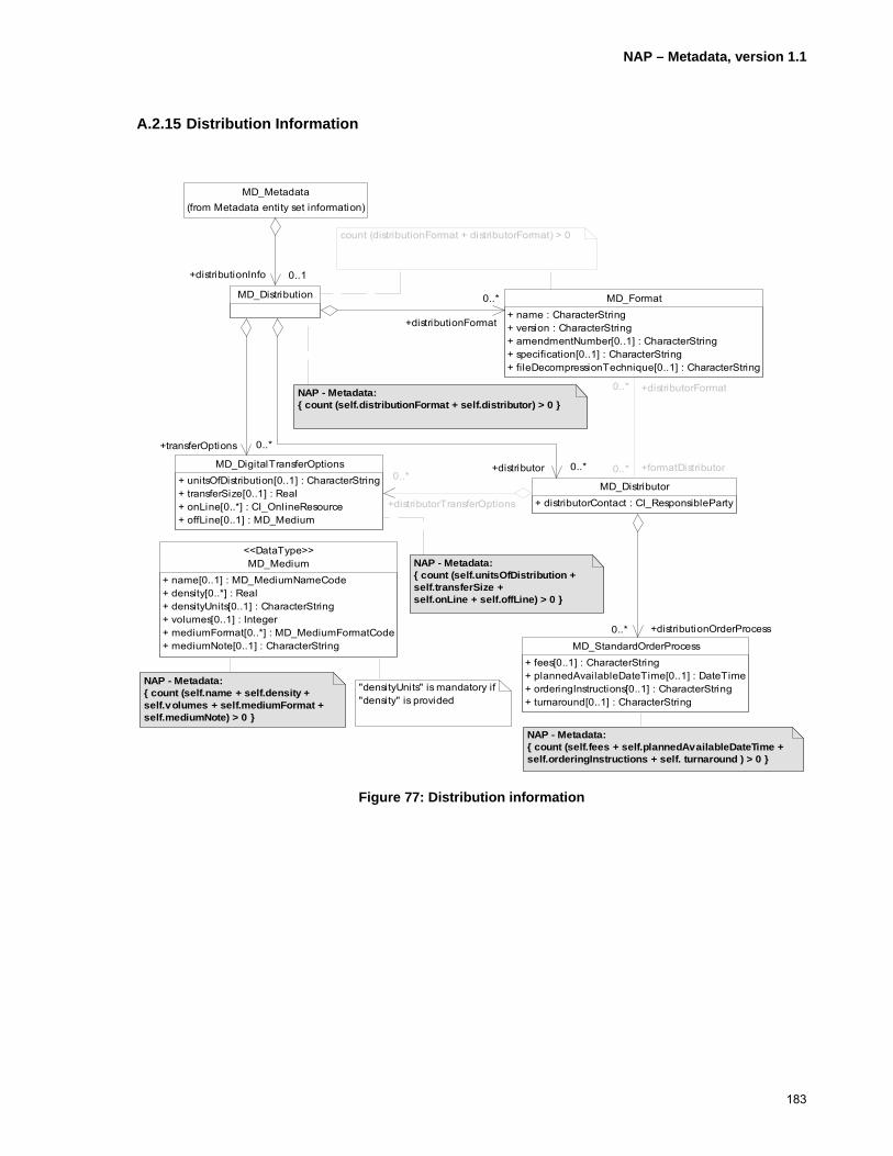
NAP – Metadata, version 1.1
183
A.2.15 Distribution Information
MD_Medium+ name[0..1] : MD_MediumNameCode+ density[0..*] : Real+ densityUnits[0..1] : CharacterString+ volumes[0..1] : Integer+ mediumFormat[0..*] : MD_MediumFormatCode+ mediumNote[0..1] : CharacterString
<<DataType>>
"densityUnits" is mandatory if "density" is provided
count (distributionFormat + distributorFormat) > 0
NAP - Metadata:{ count (self.distributionFormat + self.distributor) > 0 }
NAP - Metadata:{ count (self.unitsOfDistribution + self.transferSize +self.onLine + self.offLine) > 0 }
NAP - Metadata:{ count (self.name + self.density +self.volumes + self.mediumFormat +self.mediumNote) > 0 }
NAP - Metadata:{ count (self.fees + self.plannedAvailableDateTime +self.orderingInstructions + self. turnaround ) > 0 }
MD_Metadata(from Metadata entity set information)
MD_StandardOrderProcess+ fees[0..1] : CharacterString+ plannedAvailableDateTime[0..1] : DateTime+ orderingInstructions[0..1] : CharacterString+ turnaround[0..1] : CharacterString
MD_Format+ name : CharacterString+ version : CharacterString+ amendmentNumber[0..1] : CharacterString+ specification[0..1] : CharacterString+ fileDecompressionTechnique[0..1] : CharacterString
MD_Distribution 0..*
+distributionFormat
0..*
0..1+distributionInfo 0..1
MD_DigitalTransferOptions+ unitsOfDistribution[0..1] : CharacterString+ transferSize[0..1] : Real+ onLine[0..*] : CI_OnlineResource+ offLine[0..1] : MD_Medium
0..*+transferOptions 0..*
MD_Distributor+ distributorContact : CI_ResponsibleParty
0..* +distributionOrderProcess0..*
0..*
0..*
+formatDistributor0..*
+distributorFormat0..*
0..*+distributor 0..*0..*
+distributorTransferOptions
0..*
Figure 77: Distribution information

NAP – Metadata, version 1.1
184
A.2.16 Metadata Extension Information
Figure 78: Metadata extension information
if "d
ataT
ype"
= 'c
odel
istE
lem
ent'
then
"do
mai
nCod
e" is
man
dato
ry
if "d
ataT
ype"
not
Equ
al 'c
odel
istE
lem
ent'
then
"sh
ortN
ame"
is m
anda
tory
if "d
ataT
ype"
not
Equ
al 'c
odel
ist',
'enu
mer
atio
n' o
r 'co
delis
tEle
men
t' th
en "
oblig
atio
n", "
max
imum
Occ
uren
ce"
and
"dom
ainV
alue
" a
re m
anda
tory
if "o
blig
atio
n" =
'con
ditio
nal'
then
"co
nditi
on"
is m
anda
tory
MD
_Ext
ende
dEle
men
tInfo
rmat
ion
+ na
me
: Cha
ract
erS
tring
+ sh
ortN
ame[
0..1
] : C
hara
cter
Stri
ng+
dom
ainC
ode[
0..1
] : In
tege
r+
defin
ition
: C
hara
cter
Stri
ng+
oblig
atio
n[0.
.1] :
MD
_Obl
igat
ionC
ode
+ co
nditi
on[0
..1] :
Cha
ract
erS
tring
+ da
taT
ype
: MD
_Dat
atyp
eCod
e+
max
imum
Occ
urre
nce[
0..1
] : C
hara
cter
Stri
ng+
dom
ainV
alue
[0..1
] : C
hara
cter
Stri
ng+
pare
ntE
ntity
[1..*
] : C
hara
cter
Stri
ng+
rule
: C
hara
cter
Stri
ng+
ratio
nale
[0..*
] : C
hara
cter
Stri
ng+
sour
ce[1
..*] :
CI_
Res
pons
ible
Par
ty
MD
_Met
adat
aExt
ensi
onIn
form
atio
n+
exte
nsio
nOnL
ineR
esou
rce[
0..1
] : C
I_O
nlin
eRes
ourc
e
0..*
+ext
ende
dEle
men
tInfo
rmat
ion
0..*
MD
_Met
adat
a(fr
om M
etad
ata
entit
y se
t inf
orm
atio
n)
0..*
+met
adat
aExt
ensi
onIn
fo0.
.*
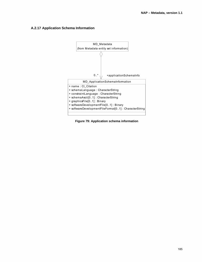
NAP – Metadata, version 1.1
185
A.2.17 Application Schema Information
MD_Metadata(from Metadata enti ty set information)
MD_Appl icationSchemaInformation+ name : CI_Citation+ schemaLanguage : CharacterString+ constraintLanguage : CharacterString+ schemaAscii[0..1] : CharacterString+ graphicsFile[0..1] : Binary+ softwareDevelopmentFile[0..1] : Binary+ softwareDevelopmentFileFormat[0..1] : CharacterString
0..* +applicationSchemaInfo0..*
Figure 79: Application schema information
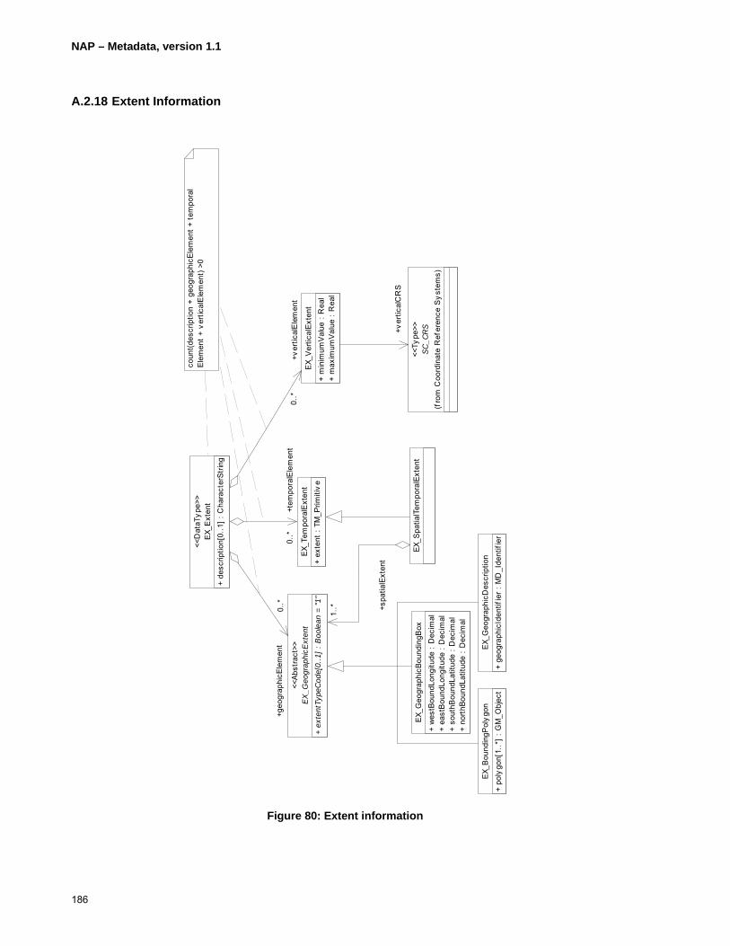
NAP – Metadata, version 1.1
186
A.2.18 Extent Information
Figure 80: Extent information
EX_G
eogr
aphi
cBou
ndin
gBox
+ w
estB
ound
Long
itude
: D
ecim
al+
east
Bou
ndLo
ngitu
de :
Dec
imal
+ so
uthB
ound
Latit
ude
: Dec
imal
+ no
rthB
ound
Latit
ude
: D
ecim
al
EX_B
ound
ingP
olyg
on+
poly
gon[
1..*
] : G
M_O
bjec
t
coun
t(des
crip
tion
+ ge
ogra
phic
Elem
ent +
tem
pora
lEl
emen
t +
vert
ical
Ele
men
t) >0
EX_T
empo
ralE
xten
t+
exte
nt :
TM_P
rimiti
ve
EX_S
patia
lTem
pora
lExt
ent
EX_E
xten
t+
desc
riptio
n[0.
.1] :
Cha
ract
erSt
ring
<<D
ataT
ype>
>
0..*
+tem
pora
lEle
men
t0.
.*
EX_G
eogr
aphi
cExt
ent
+ ex
tent
Type
Cod
e[0.
.1]
: Boo
lean
= "
1"
<<Ab
stra
ct>>
1..* +s
patia
lExt
ent
1..*0.
.*+g
eogr
aphi
cEle
men
t0.
.*
EX_G
eogr
aphi
cDes
crip
tion
+ ge
ogra
phic
Iden
tifie
r : M
D_I
dent
ifie
r
EX_V
ertic
alEx
tent
+ m
inim
umV
alue
: R
eal
+ m
axim
umV
alue
: R
eal
0..*
+ver
tical
Ele
men
t0.
.*
SC_C
RS
(fro
m C
oord
inat
e R
efer
ence
Sys
tem
s)
<<Ty
pe>>+v
ertic
alC
RS

NAP – Metadata, version 1.1
187
A.2.19 Citation and Responsible Party Information
CI_Telephone+ voice[0..*] : CharacterString+ facsimile[0..*] : CharacterString
<<DataType>>
CI_Address+ deliveryPoint[0..1] : CharacterString+ city[0..1] : CharacterString+ administrativeArea[0..1] : CharacterString+ postalCode[0..1] : CharacterString+ country[0..1] : CharacterString+ electronicMailAddress[0..*] : CharacterString
<<DataType>>
CI_OnlineResource+ linkage : URL+ protocol : CharacterString+ applicationProfi le[0..1] : CharacterString+ name[0..1] : CharacterString+ description[0..1] : CharacterString+ function[0..1] : CI_OnLineFunctionCode
<<DataType>>
CI_Citation+ title : CharacterString+ alternateTitle[0..*] : CharacterString+ date[1..*] : CI_Date+ edition[0..1] : CharacterString+ editionDate[0..1] : Date+ identifier[0..*] : MD_Identifier+ citedResponsibleParty[1..*] : CI_ResponsibleParty+ presentationForm[0..*] : CI_PresentationFormCode+ series[0..1] : CI_Series+ otherCitationDetails[0..1] : CharacterString+ collectiveTitle[0..1] : CharacterString+ ISBN[0..1] : CharacterString+ ISSN[0..1] : CharacterString
<<DataType>>
URL
CI_Contact+ phone[0..1] : CI_Telephone+ address[0..1] : CI_Address+ onlineResource[0..1] : CI_OnlineResource+ hoursOfService[0..1] : CharacterString+ contactInstructions[0..1] : CharacterString
<<DataType>>
CI_ResponsibleParty+ individualName[0..1] : CharacterString+ organisationName[0..1] : CharacterString+ positionName[0..1] : CharacterString+ contactInfo[0..1] : CI_Contact+ role : CI_RoleCode
<<DataType>>
count of (individualName + organisationName + positionName) > 0
CI_Date+ date : Date+ dateType : CI_DateTypeCode
<<DataType>>
CI_Series+ name[0..1] : CharacterString+ issueIdentification[0..1] : CharacterString+ page[0..1] : CharacterString
<<DataType>>
NAP - Metadata:+ deliveryPoint: maximum multiplicity = 1, maximum one delivery point can be provided+ { count (self.deliveryPoint + self.city + self.administrativeArea + self.postalCode + self.country + self.electronicMailAddress) > 0 }
NAP - Metadata:{ count (self.name + self.issueIdentification) > 0 }
NAP - Metadata:+ protocol: Mandatory
NAP - Metadata:+ citedResponsibleParty: Mandatory
NAP - Metadata:{ count (self.phone + self.address + self.onlineResource) > 0 }
NAP - Metadata:{ count (self.voice + self.facsimile) > 0 }
Figure 81: Citation and responsible party information

NAP – Metadata, version 1.1
188
Annex B
Data Types
(normative)
B.1 Binary
Any binary data (e.g. image, sound) encoded as a sequence of bits.
(see ISO/TS19133:2005, Geographic information – Location based services – Tracking and navigation, clause 10.2.3).
B.2 Boolean
Truth value representing true or false. True can be represented by {true, 1} and false by {false, 0}
(see ISO/TS19103:2005, Geographic information - Conceptual schema language, clause 6.5.2.11).
B.3 CharacterString
An arbitrary-length sequence of characters, including accents and special characters, from the identified character set.
B.4 Date
Date gives values for the representation of:
1. year, e.g. 2006
2. year and month, e.g. 2006-10
(see ISO/TS19103:2005, Geographic information - Conceptual schema language, clause 6.5.2.8, and ISO/TS19139:2007, Geographic information – Metadata – XML schema implementation, clause 8.5.8.4.7)
B.5 DateTime
Date gives values for the representation of year, month, day, and time of the day in terms of hours, minutes, and seconds, with an optional time zone. Example 2006-10-01T12:00:00-05:00 corresponds to noon on October 1st, 2006, Eastern Standard Time in the U.S.
(see ISO/TS19103:2005, Geographic information - Conceptual schema language, clause 6.5.2.8, and ISO/TS19139:2007, Geographic information – Metadata – XML schema implementation, clause 8.5.8.4.7)
B.6 Decimal
A number that represents an exact value, e.g. 2.5, 5.25, 12.125
(see ISO/TS19103:2005, Geographic information - Conceptual schema language, clause 6.5.2.4).
B.7 Distance
A measure of length between two points. A distance is made of a value and a unit of measure (uom).
NAP – Metadata, version 1.1
189
(see ISO/TS19103:2005, Geographic information - Conceptual schema language, clause 6.5.7.7).
B.8 GenericName
An abstract class for the representation of a name in a namespace. A GenericName can be either a LocalName or a ScopedName. As defined in ISO19139:2007, the representation of generic names follows the following XML schema:
<xs:element name="featureTypes" type="gco:GenericName_PropertyType" minOccurs="0" maxOccurs="unbounded"/> <xs:element name="AbstractGenericName" type="gml:CodeType" abstract="true"/> <xs:complexType name="GenericName_PropertyType">
<xs:sequence minOccurs="0"> <xs:element ref="gco:AbstractGenericName"/>
</xs:sequence> <xs:attribute ref="gco:nilReason"/>
</xs:complexType> <xs:element name="LocalName" type="gml:CodeType" substitutionGroup="gco:AbstractGenericName"/> <xs:element name="ScopedName" type="gml:CodeType" substitutionGroup="gco:AbstractGenericName"/>
An instance corresponding to a featureTypes element might appear in the document as follows:
<featureTypes> <LocalName codeSpace = “http://www....”>building</LocalName>
</featureTypes>
(see ISO/TS19103:2005, Geographic information - Conceptual schema language, clause 6.5.6.3).
B.9 GF_AttributeType
ISO19109:2005, Geographic information – Rules for application schema metaclass used for the representation of an attribute of a class of features, e.g. “numberOfLane”, and “buildingUsage.”
(see ISO19109:2005, Geographic information – Rules for application schema, clause 7.3.6).
B.10 GF_FeatureType
ISO19109:2005, Geographic information – Rules for application schema metaclass used for the representation of a class of features, e.g. “road”, “river”, and “building.”
(see ISO19109:2005, Geographic information – Rules for application schema, clause 7.3.4).
B.11 GM_Object
ISO19107:2003, Geographic information – Spatial schema abstract classes standing for any geometric objects (e.g. GM_Point, GM_Curve, GM_Surface) for the representation of the geometry of objects.
(see ISO19107:2003, Geographic information – Spatial schema, clause 6.2.2).
B.12 GM_Point
ISO19107:2003, Geographic information – Spatial schema data type for the representation of a single point.
NAP – Metadata, version 1.1
190
(see ISO19107:2003, Geographic information – Spatial schema, clause 6.3.11).
B.13 Integer
A signed number with no fractional part, e.g.: -12, 125, 12000963.
(see ISO/TS19103:2005, Geographic information - Conceptual schema language, clause 6.5.2.3).
B.14 Measure
A value resulting from the process to evaluate an amount or a quantity expressed in a unit of measure. A measure is made of a value and a unit of measure.
(see ISO/TS19103:2005, Geographic information - Conceptual schema language, clause 6.5.7.2).
B.15 MemberName
A name that references an attribute in a record, a RecordType, an attribute, an operation, or an association role.
(see ISO/TS19103:2005, Geographic information - Conceptual schema language, clause 6.5.6.7).
B.16 Real
A signed floating point number composed of a mantissa and an optional exponent, e.g. -2E5, 364.236E8, 15.32e-3, 24, -0, 0.
(see ISO/TS19103:2005, Geographic information - Conceptual schema language, clause 6.5.2.5).
B.17 Record
A structure of logically related elements.
(see ISO/TS19103:2005, Geographic information - Conceptual schema language, clause 6.5.5).
B.18 RecordType
A specification of the content and structure of a Record.
(see ISO/TS19103:2005, Geographic information - Conceptual schema language, clause 6.5.5).
B.19 SC_CRS
A coordinate reference system documented according to ISO/FDIS19111rev., Geographic information – Spatial referencing by coordinates.
B.20 Sequence
A sequence is an ordered collection of elements. An element may be repeated as appropriate. List is a synonym of sequence.
NAP – Metadata, version 1.1
191
B.21 TM_PeriodDuration
Time spans by an object or an event. A TM_PeriodDuration of 5 years, 1 month, 6 days, 12 hours, and 35 minutes is represented by P5Y1M6DT12H35M. Any subset of this representation is allowed as long as one unit is represented, e.g. a period duration of minus 80 days is represented as –P80D.
(see ISO19108:2003, Geographic information – Temporal schema, clause 5.2.3.7).
B.22 TM_Primitive
TM_Primitive is an abstract data type for temporal geometric primitives (TM_Instant and TM_Period) and temporal topological primitives (TM_Node and TM_Edge).
(see ISO19108:2003, Geographic information – Temporal schema, clause 5.2.2).
B.23 Type
Any valid data type in a namespace.
B.24 UnitOfMeasure
A quantity adopted as a standard unit of measure, e.g. metre, degree, kilogram.
(see ISO/TS19103:2005, Geographic information - Conceptual schema language, clause 6.5.7.3).
B.25 UomLength
Reference quantities to express the value of a length, e.g. metre
(see ISO/TS19103:2005, Geographic information - Conceptual schema language, clause 6.5.7.8).
B.26 URL
A uniform resource locator, e.g. www.fgdc.gov/north-american-profile

NAP – Metadata, version 1.1
192
Annex C
Conformance Clauses
(normative)
C.1 Conformance Requirements
Metadata instance documents implementing this standard shall be considered in conformance if they comply with the rules stated in Clause 5, Clause 6, Annex A, and Annex B and meet the following tests:
C.1.1 Completeness
All metadata instance documents must contain all mandatory and conditional (if conditions apply) metadata elements defined in this document.
C.1.2 Semantics
All metadata instance documents implementing this standard must use the metadata elements provided in this standard for the purposes for which they were defined.
C.1.3 Schema
All metadata instance documents implementing this standard must contain metadata organized as specified in this standard.
C.1.4 Maximum Occurrences
All metadata instance documents implementing this standard must contain not more than the specified number of occurrences of metadata component classes or attributes.
C.1.5 Data Types
All metadata instance documents implementing this standard must use data types as specified in this standard and in the manner specified.
C.1.6 Codelists
All metadata instance documents implementing this standard must use codelists as defined in this standard or extensions of these codelists, which are listed and documented within the NAP – Metadata Register.
C.2 User Defined Extension Metadata Conformance
C.2.1 Exclusiveness
User defined metadata elements must not duplicate elements defined in this standard.
C.2.2 Structure
User defined metadata elements must be integrated correctly and must not disrupt the schema defined in this standard.

NAP – Metadata, version 1.1
193
C.2.3 Extended Codelists
User extended codelists must include the original codes in the same order with the new codes appended to the end of the list.
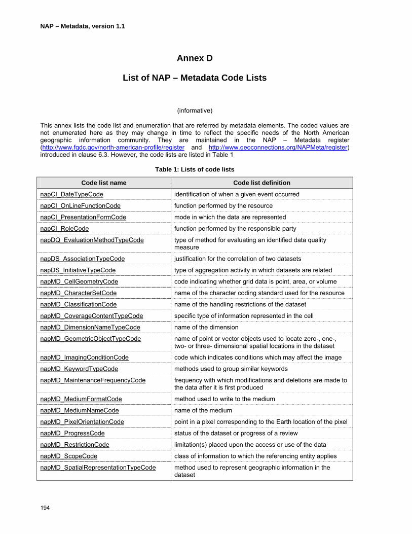
NAP – Metadata, version 1.1
194
Annex D
List of NAP – Metadata Code Lists
(informative)
This annex lists the code list and enumeration that are referred by metadata elements. The coded values are not enumerated here as they may change in time to reflect the specific needs of the North American geographic information community. They are maintained in the NAP – Metadata register (http://www.fgdc.gov/north-american-profile/register and http://www.geoconnections.org/NAPMeta/register) introduced in clause 6.3. However, the code lists are listed in Table 1
Table 1: Lists of code lists
Code list name Code list definition
napCI_DateTypeCode identification of when a given event occurred
napCI_OnLineFunctionCode function performed by the resource
napCI_PresentationFormCode mode in which the data are represented
napCI_RoleCode function performed by the responsible party
napDQ_EvaluationMethodTypeCode type of method for evaluating an identified data quality measure
napDS_AssociationTypeCode justification for the correlation of two datasets
napDS_InitiativeTypeCode type of aggregation activity in which datasets are related
napMD_CellGeometryCode code indicating whether grid data is point, area, or volume
napMD_CharacterSetCode name of the character coding standard used for the resource
napMD_ClassificationCode name of the handling restrictions of the dataset
napMD_CoverageContentTypeCode specific type of information represented in the cell
napMD_DimensionNameTypeCode name of the dimension
napMD_GeometricObjectTypeCode name of point or vector objects used to locate zero-, one-, two- or three- dimensional spatial locations in the dataset
napMD_ImagingConditionCode code which indicates conditions which may affect the image
napMD_KeywordTypeCode methods used to group similar keywords
napMD_MaintenanceFrequencyCode frequency with which modifications and deletions are made to the data after it is first produced
napMD_MediumFormatCode method used to write to the medium
napMD_MediumNameCode name of the medium
napMD_PixelOrientationCode point in a pixel corresponding to the Earth location of the pixel
napMD_ProgressCode status of the dataset or progress of a review
napMD_RestrictionCode limitation(s) placed upon the access or use of the data
napMD_ScopeCode class of information to which the referencing entity applies
napMD_SpatialRepresentationTypeCode method used to represent geographic information in the dataset

NAP – Metadata, version 1.1
195
napMD_TopicCategoryCode high-level geographic data thematic classification to assist in the grouping and search of available geographic data sets
napMD_TopologyLevelCode degree of complexity of the spatial relationships
nap_DCPList type of distributed computing platform or environment
napSV_ParameterDirection class of information to which the referencing entity applies
napSV_CouplingType class of information to which the referencing entity applies
napMD_FileFormatCode code identifying a file format
ISO639-2_LanguageNameCodes ISO standard codes for the representation of names of languages as listed at http://www.loc.gov/standards/iso639-2/php/English_list.php
ISO3166-1_CountryNameCodes ISO standard country name codes as listed at http://www.iso.org/iso/en/prods-services/iso3166ma/index.html and http://userpage.chemie.fu-berlin.de/diverse/doc/ISO_3166.html
ISO4217_CurrencyNamesAndCodeElements ISO standard currency codes as listed at http://www.iso.org/iso/en/prods-services/popstds/currencycodeslist.html

NAP – Metadata, version 1.1
196
Annex E
Metadata Implementation
(informative)
E.1 Background
NAP – Metadata outlines the format to be used for definitions, data types, and relationships among geographic metadata elements. In order to use these elements to create, modify, discover, evaluate, present, and/or access the metadata records of which they form a part and the related spatial data they describe, it is necessary to manage the elements in software implementations and to provide for the exchange of metadata between such data management systems. This, in turn, requires that the metadata elements be encoded in a clear and consistent manner.
This Annex provides an overview and some examples of how to encode the metadata elements listed in this Standard. It specifically covers the creation of metadata records for single datasets, services, and aggregations of information objects. The examples provided are in Canadian English. However, users may also create records in American English or Canadian French when implementing NAP – Metadata. The resource described by the Metadata record may be available in any language.
The examples in Section E.5 are provided in XML format with element values in clear text and role names from NAP Section 5 embedded in the XML tags. Best practices and the use of optional elements are described as Comments before and after each such usage
E.2 Metadata Records for Single Datasets
Datasets are the most common type of resource for which Metadata Records are created. The example in Section E.5.3 includes a Metadata entity for a dataset entitled “Nesting Site – North Bay District”. The same dataset also is used as an example of a component dataset associated with a Metadata entity for a Series dataset (see E.5.2). In this case, the Ontario Ministry of Natural Resources (OMNR) has a data class entitled “Nesting Site – Province of Ontario” for all of Ontario that is maintained by 26 different, geographically discrete, district offices. Since the period of maintenance, the contact, and the geographic coverage for each district is unique, a discrete, dataset-level metadata entity was created for each District in addition to the Series-level metadata record for the entire Province. For an explanation of the use of Hierarchy, see Section E4.
E.3 Metadata Records for Services
Discrete metadata entities can exist to describe a service alone, an information object alone, a service that is tightly coupled to one or more information objects, or an information object that is tightly coupled to one or more services. The example provided in Section E.5.2 below describes an OGC-compliant Web Map Service (WMS) as part of the metadata entity for the information object called “Nesting Site – Province of Ontario”. It is recommended that additional metadata entities exist for other information objects made available through the same service. It is also recommended that an additional metadata entity exist for the service, listing each of the information objects available through that service.
E.4 Information Object Aggregations
Information objects are often aggregated. NAP – Metadata distinguishes between two broad categories of aggregations: those where the component information objects share one or more characteristics, referred to as Series; and, those where the component information objects do not share characteristics. For further information see Section A1, above.
NAP – Metadata, version 1.1
197
E.4.1 Collection metadata (optional)
A dataset collection is a group of datasets that have been assembled to meet a common objective. Examples of dataset collection metadata entries that do not inherit characteristics may include:
• A group of metadata entities each describing objects collected by an individual, as understood by the archival term “fonds”;
• A group of datasets or services used by a single application or a single map;
• A group of otherwise unrelated datasets held or maintained by the same individual or organization;
• A group of satellite images, or printed maps, that cover roughly the same geographic area produced by different processes or processors;
• A group representing all metadata entities found in a single repository;
• A group of metadata entities found in one or more repositories that fulfil a specific search criterion.
The creation of a “dataset collection” metadata level is an optional feature that allows users to refer to a single object for convenience. When there are no shared characteristics among the component information objects, the metadata entity definition of this type of metadata will not be adequate for an assessment of those component information objects.
E.4.2 Series metadata (optional)
Series metadata incorporates the concept of hierarchy levels. The basic principle behind distinguishing among levels of Metadata is that a lower level, sometimes referred to as the child, inherits the characteristics of an upper level, often referred to as the parent. A child metadata entity can have many parents. In order to avoid repeating the same description for all levels, only those characteristics that are different are added to the child records. For example, if the distributor of the data remains the same, this need not be carried down the structure. In order to clarify this concept, the following example follows the life cycle of an example set of geographic data.
A series is a group of information objects that share one or more of characteristics such as subject matter, geographic area, time period, spatial representation, methodology, custodian or distributor. Examples of series metadata entries may include:
• A group of aerial photographs captured during a single flight with one camera and film type.
• A group of vector datasets depicting the same features for multiple administrative areas.
• A group of the same thematic dataset in the same geographic area for multiple years.
• A group of raster map data captured from the same paper map source.
A Series can, itself, be part of another Series. For example, a Series of Series might include:
• A series of groups of aerial photographs captured at regular intervals (eg annually).
• A series of groups of single-feature vector datasets for multiple areas in the same jurisdiction.
• A series of thematic groupings (eg transportation) of datasets in the same geographic area.
The creation of a “series” metadata level is an optional feature that allows users to consult higher-level characteristics for data search. The definition of this type of metadata may be adequate for the initial
NAP – Metadata, version 1.1
198
characterization of available spatial data, but may not be adequate for detailed assessment of data quality of specific datasets. See example in Section E.5.2, below.
E.4.3 Dataset metadata
For the purposes of this North American Standard, a dataset should be a consistent spatial data product instance that can be generated or made available by a spatial data distributor. A dataset may be a member of a data series, as defined in the previous sub clause. A dataset may be composed of a set of identified feature types and instances, and attribute types and instances as described in the following four sub clauses. On a demand basis, metadata from series and dataset information will be merged to present the user with a view of the metadata at the dataset level of abstraction. Metadata for which no hierarchy is listed are interpreted to be “dataset” metadata, by default. See example in Section E.5.3, below.
E.4.4 Feature type metadata (optional)
Constructs known as features are grouped with common characteristics. Spatial data services may elect to support feature type-level metadata where it is available and make such metadata available for query or retrieval. Feature Type-level metadata, together with feature instance attribute type and attribute instance level metadata, will be grouped into datasets, as defined in the previous sub clause. See example in Section E.5.4, below.
E.4.5 Feature instance metadata (optional)
Feature instances are spatial constructs (features) that have a direct correspondence with a real world object. Spatial data services may elect to support feature instance-level metadata where it is available and make such metadata available for query or retrieval. Feature Instance-level metadata, together with feature type, attribute type, and attribute instance-level metadata, will be grouped into datasets. Examples of feature instance metadata entries may include:
A specific Great Blue Heron Nest site.
E.4.6 Attribute type metadata (optional)
Attribute types are the digital parameters that describe a common aspect of grouped spatial primitives (0-, 1-, 2-, and 3-dimensional geometric objects). Spatial data services may elect to support attribute type-level metadata where it is available and make such metadata available for query or retrieval. Attribute type-level metadata, together with feature type-, feature instance-, and attribute instance-level metadata, will be grouped into datasets. An example of an attribute type metadata entry may include:
Height above ground (of a Great Blue Heron Nest).
E.4.7 Attribute instance metadata (optional)
Attribute instances are the digital parameters that describe an aspect of a feature instance. Spatial data services may elect to support attribute instance-level metadata where it is available and make such metadata available for query or retrieval. Attribute instance-level metadata, together with feature type-, feature instance-, and attribute type-level metadata, will be grouped into datasets. An example of an attribute instance metadata entry may include:
Height above ground of a specific Great Blue Heron Nest.
E.5 Example
E.5.1 Example Metadata Hierarchy
Metadata can describe any object of interest, termed a resource, to help find it, use it, or determine its suitability to fulfil a certain purpose. The most common type of resource for which geospatial metadata

NAP – Metadata, version 1.1
199
records are created is the Dataset. Datasets usually include one or more Feature types. Each Feature type is defined through the use of attributes. Often attributes are limited to a specific list of valid values.
This hierarchy of metadata can be graphically represented as shown in Figure 82.
Data Series
Dataset Dataset
Feature Type Attribute Type Feature Instance
Attribute Instance
Figure 82: Metadata hierarchy
Datasets can be part of a parent series or collection of datasets. A series or collection of datasets can, in turn, be part of another parent series or collection. NAP – Metadata permits the creation of metadata records for features, datasets, series and series of series.
The following hierarchy chart (Figure 83) illustrates the logical implementation of a dataset series level, dataset level and feature level metadata record utilizing a hierarchy approach. It is not intended to demonstrate any particular expertise in the subject area, or to recommend a particular information architecture or data model. In this example the data custodian has created a series of datasets representing all bird nesting sites in Ontario, Canada. This is a single, physical database. Each dataset in the series contains all nesting sites for a specific geographic area. Each dataset is maintained locally and then posted to the primary database. The feature types in each dataset are the specific types of nests found in that geographic area. The feature attributes apply to each specific type of nest. Metadata records were created for the series, for each dataset, and for each feature type in each dataset.
The example below illustrates how the three hierarchical metadata records inherit values from one another:
• Dataset Series Level (E.5.2 – Nesting Site - Province of Ontario)
• Dataset Level (E.5.3 – Nesting Site – North Bay District)
• Feature Level (E.5.4 – Nesting Site – North Bay District - Great Blue Heron Nesting Site/Colony)
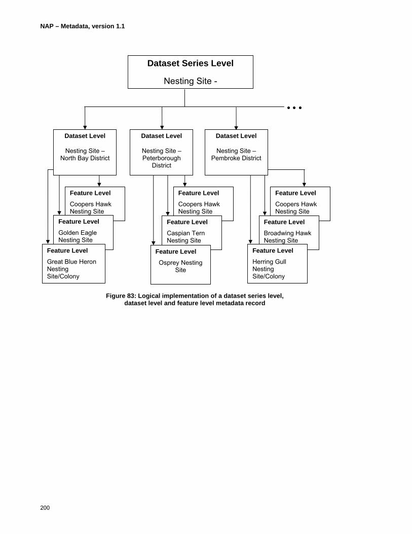
NAP – Metadata, version 1.1
200
Figure 83: Logical implementation of a dataset series level, dataset level and feature level metadata record
Feature Level
Coopers Hawk Nesting Site
Feature Level
Broadwing Hawk Nesting Site
Dataset Series Level
Nesting Site -
Dataset Level
Nesting Site – North Bay District
Dataset Level
Nesting Site – Peterborough
District
Dataset Level
Nesting Site – Pembroke District
Feature Level
Herring Gull Nesting Site/Colony
Feature Level
Coopers Hawk Nesting Site
Feature Level
Caspian Tern Nesting Site
Feature Level
Osprey Nesting Site
Feature Level
Coopers Hawk Nesting Site
Feature Level
Golden Eagle Nesting Site
Feature Level
Great Blue Heron Nesting Site/Colony

NAP – Metadata, version 1.1
201
E.5.2 Dataset Series Metadata – Nesting Site – Province of Ontario
<?xml version="1.0" encoding="UTF-8"?> <MD_Metadata xmlns="http://www.isotc211.org/2005/gmd" xmlns:gco="http://www.isotc211.org/2005/gco" xmlns:gts="http://www.isotc211.org/2005/gts" xmlns:gss="http://www.isotc211.org/2005/gss" xmlns:gsr="http://www.isotc211.org/2005/gsr" xmlns:xlink="http://www.w3.org/1999/xlink" xmlns:srv="http://www.isotc211.org/2005/srv" xmlns:gml="http://www.opengis.net/gml" xmlns:xsi="http://www.w3.org/2001/XMLSchema-instance" xsi:schemaLocation="http://www.isotc211.org/2005/gmd C:\schemas\iso19139\gmd\gmd.xsd"> <fileIdentifier> <gco:CharacterString>260</gco:CharacterString> </fileIdentifier> <language> <gco:CharacterString>eng; CAN</gco:CharacterString> </language> <characterSet> <MD_CharacterSetCode codeList="http://www.tc211.org/ISO19139/resources/codeList.xml#MD_CharacterSetCode" codeListValue="utf8">utf8</MD_CharacterSetCode> </characterSet> <hierarchyLevel> <MD_ScopeCode codeList="http://www.tc211.org/ISO19139/resources/codeList.xml#MD_ScopeCode" codeListValue="dataset">dataset</MD_ScopeCode> </hierarchyLevel> <hierarchyLevelName> <gco:CharacterString>Series of Geographic Areas in the Province of Ontario</gco:CharacterString> </hierarchyLevelName> <contact> <CI_ResponsibleParty> <organisationName> <gco:CharacterString>Ontario Ministry of Natural Resources</gco:CharacterString> </organisationName> <positionName> <gco:CharacterString>Land Information Ontario - Support</gco:CharacterString> </positionName> <contactInfo> <CI_Contact> <phone> <CI_Telephone> <voice> <gco:CharacterString>1 (705) 7551878</gco:CharacterString> </voice> <facsimile> <gco:CharacterString>1 (705) 7551677</gco:CharacterString> </facsimile> </CI_Telephone> </phone> <address> <CI_Address> <deliveryPoint> <gco:CharacterString>physical; 300; Water Street; ;</gco:CharacterString> </deliveryPoint> <city> <gco:CharacterString>Peterborough</gco:CharacterString> </city> <administrativeArea> <gco:CharacterString>Ontario</gco:CharacterString> </administrativeArea> <postalCode> <gco:CharacterString>K9J 8M5</gco:CharacterString>

NAP – Metadata, version 1.1
202
</postalCode> <country> <gco:CharacterString>Canada</gco:CharacterString> </country> <electronicMailAddress> <gco:CharacterString>[email protected]</gco:CharacterString> </electronicMailAddress> </CI_Address> </address> </CI_Contact> </contactInfo> <role> <CI_RoleCode codeList="http://www.tc211.org/ISO19139/resources/codeList.xml#CI_RoleCode" codeListValue="pointOfContact">pointOfContact</CI_RoleCode> </role> </CI_ResponsibleParty> </contact> <dateStamp> <gco:Date>20060630</gco:Date> </dateStamp> <metadataStandardName> <gco:CharacterString>NAP - Metadata</gco:CharacterString> </metadataStandardName> <metadataStandardVersion> <gco:CharacterString>1.0</gco:CharacterString> </metadataStandardVersion> <dataSetURI> <gco:CharacterString>http://lioapp.lrc.gov.on.ca/edwin/EDWINCGI.exe?IHID=260&AgencyID=1& Theme=All_Themes</gco:CharacterString> </dataSetURI> <locale> <PT_Locale> <languageCode> <LanguageCode codeList="http://www.tc211.org/ISO19139/resources/codeList.xml#LanguageCode" codeListValue="eng">English</LanguageCode> </languageCode> <country> <Country codeList="http://www.tc211.org/ISO19139/resources/codeList.xml#CountryCode" codeListValue="CAN">Canada</Country> </country> <characterEncoding> <MD_CharacterSetCode codeList="http://www.tc211.org/ISO19139/resources/codeList.xml#MD_CharacterSetCode" codeListValue="utf8">utf8</MD_CharacterSetCode> </characterEncoding> </PT_Locale> </locale> <spatialRepresentationInfo> <MD_VectorSpatialRepresentation> <topologyLevel> <MD_TopologyLevelCode codeList="http://www.tc211.org/ISO19139/resources/codeList.xml#MD_TopologyLevelCode" codeListValue="geometryOnly">geometryOnly</MD_TopologyLevelCode> </topologyLevel> <geometricObjects> <MD_GeometricObjects> <geometricObjectType>

NAP – Metadata, version 1.1
203
<MD_GeometricObjectTypeCode codeList="http://www.tc211.org/ISO19139/resources/codeList.xml#MD_GeometricObjectTypeCode" codeListValue="point">point</MD_GeometricObjectTypeCode> </geometricObjectType> <geometricObjectCount> <gco:Integer>6308</gco:Integer> </geometricObjectCount> </MD_GeometricObjects> </geometricObjects> </MD_VectorSpatialRepresentation> </spatialRepresentationInfo> <referenceSystemInfo> <MD_ReferenceSystem> <referenceSystemIdentifier> <RS_Identifier> <code> <gco:CharacterString>NAD83</gco:CharacterString> </code> </RS_Identifier> </referenceSystemIdentifier> </MD_ReferenceSystem> </referenceSystemInfo> <identificationInfo> <MD_DataIdentification> <citation> <CI_Citation> <title> <gco:CharacterString>Nesting Site - Province of Ontario</gco:CharacterString> </title> <date> <CI_Date> <date> <gco:Date>19970818</gco:Date> </date> <dateType> <CI_DateTypeCode codeList="http://www.tc211.org/ISO19139/resources/codeList.xml#CI_DateTypeCode" codeListValue="creation">creation</CI_DateTypeCode> </dateType> </CI_Date> </date> <date> <CI_Date> <date> <gco:Date>20060219</gco:Date> </date> <dateType> <CI_DateTypeCode codeList="http://www.tc211.org/ISO19139/resources/codeList.xml#CI_DateTypeCode" codeListValue="revision">revision</CI_DateTypeCode> </dateType> </CI_Date> </date> <citedResponsibleParty> <CI_ResponsibleParty> <organisationName> <gco:CharacterString>Ministry of Natural Resources</gco:CharacterString> </organisationName> <positionName>
NAP – Metadata, version 1.1
204
<gco:CharacterString>Land Information Ontario Support</gco:CharacterString> </positionName> <contactInfo> <CI_Contact> <phone> <CI_Telephone> <voice> <gco:CharacterString>1 (705) 7551878</gco:CharacterString> </voice> <facsimile> <gco:CharacterString>1 (705) 7551677</gco:CharacterString> </facsimile> </CI_Telephone> </phone> <address> <CI_Address> <deliveryPoint> <gco:CharacterString>physical; 300; Water Street; ;</gco:CharacterString> </deliveryPoint> <city> <gco:CharacterString>Peterborough</gco:CharacterString> </city> <administrativeArea> <gco:CharacterString>Ontario</gco:CharacterString> </administrativeArea> <postalCode> <gco:CharacterString>K7J 8M5</gco:CharacterString> </postalCode> <country> <gco:CharacterString>Canada</gco:CharacterString> </country> <electronicMailAddress> <gco:CharacterString>[email protected]</gco:CharacterString> </electronicMailAddress> </CI_Address> </address> </CI_Contact> </contactInfo> <role> <CI_RoleCode codeList="http://www.tc211.org/ISO19139/resources/codeList.xml#CI_RoleCode" codeListValue="pointOfContact">pointOfContact</CI_RoleCode> </role> </CI_ResponsibleParty> </citedResponsibleParty> <citedResponsibleParty> <CI_ResponsibleParty> <organisationName> <gco:CharacterString>Ministry of Natural Resources</gco:CharacterString> </organisationName> <positionName> <gco:CharacterString>Land Information Ontario Support</gco:CharacterString> </positionName> <contactInfo> <CI_Contact> <phone> <CI_Telephone> <voice> <gco:CharacterString>1 (705) 7551878</gco:CharacterString> </voice>

NAP – Metadata, version 1.1
205
<facsimile> <gco:CharacterString>1 (705) 7551677</gco:CharacterString> </facsimile> </CI_Telephone> </phone> <address> <CI_Address> <deliveryPoint> <gco:CharacterString>physical; 300; Water Street; ;</gco:CharacterString> </deliveryPoint> <city> <gco:CharacterString>Peterborough</gco:CharacterString> </city> <administrativeArea> <gco:CharacterString>Ontario</gco:CharacterString> </administrativeArea> <postalCode> <gco:CharacterString>K7J 8M5</gco:CharacterString> </postalCode> <country> <gco:CharacterString>Canada</gco:CharacterString> </country> <electronicMailAddress> <gco:CharacterString>[email protected]</gco:CharacterString> </electronicMailAddress> </CI_Address> </address> </CI_Contact> </contactInfo> <role> <CI_RoleCode codeList="http://www.tc211.org/ISO19139/resources/codeList.xml#CI_RoleCode" codeListValue="custodian">custodian</CI_RoleCode> </role> </CI_ResponsibleParty> </citedResponsibleParty> <citedResponsibleParty> <CI_ResponsibleParty> <organisationName> <gco:CharacterString>Ministry of Natural Resources</gco:CharacterString> </organisationName> <positionName> <gco:CharacterString>Land Information Ontario Support</gco:CharacterString> </positionName> <contactInfo> <CI_Contact> <phone> <CI_Telephone> <voice> <gco:CharacterString>1 (705) 7551878</gco:CharacterString> </voice> <facsimile> <gco:CharacterString>1 (705) 7551677</gco:CharacterString> </facsimile> </CI_Telephone> </phone> <address> <CI_Address> <deliveryPoint> <gco:CharacterString>physical; 300; Water Street; ;</gco:CharacterString>

NAP – Metadata, version 1.1
206
</deliveryPoint> <city> <gco:CharacterString>Peterborough</gco:CharacterString> </city> <administrativeArea> <gco:CharacterString>Ontario</gco:CharacterString> </administrativeArea> <postalCode> <gco:CharacterString>K7J 8M5</gco:CharacterString> </postalCode> <country> <gco:CharacterString>Canada</gco:CharacterString> </country> <electronicMailAddress> <gco:CharacterString>[email protected]</gco:CharacterString> </electronicMailAddress> </CI_Address> </address> <onlineResource> <CI_OnlineResource> <linkage> <URL>http://www.lio.mnr.gov.on.ca/en/OGDELogin.htm</URL> </linkage> <protocol> <gco:CharacterString>http</gco:CharacterString> </protocol> <description> <gco:CharacterString>Secure Web-based application by which registered individuals affiliated with organizations that are members of a Data Exchange administered by Land Information Ontario can order data sets to which they have appropriate access permission. Upon ordering the data sets are either prepared for download, and notice sent to requestor, or packaged and distributed offline.</gco:CharacterString> </description> <function> <CI_OnLineFunctionCode codeList="http://www.tc211.org/ISO19139/resources/codeList.xml#CI_OnLineFunctionCode" codeListValue="order">order</CI_OnLineFunctionCode> </function> </CI_OnlineResource> </onlineResource> <hoursOfService> <gco:CharacterString>24/7</gco:CharacterString> </hoursOfService> <contactInstructions> <gco:CharacterString>If you are not a member of a Data Exchange, please contact Land Information Ontario Information Access unit by email at [email protected] or by telephone at 705-755-1878.</gco:CharacterString> </contactInstructions> </CI_Contact> </contactInfo> <role> <CI_RoleCode codeList="http://www.tc211.org/ISO19139/resources/codeList.xml#CI_RoleCode" codeListValue="distributor">distributor</CI_RoleCode> </role> </CI_ResponsibleParty> </citedResponsibleParty> </CI_Citation> </citation> <abstract>

NAP – Metadata, version 1.1
207
<gco:CharacterString>A Nesting Site is a point feature that identifies the location of one or more nests that belong to a particular species. This Series is a single, physical collection of data representing an aggregation of discrete Nesting Site Datasets for each of the 26 Ontario Ministry of Natural Resources District.</gco:CharacterString> </abstract> <purpose> <gco:CharacterString>To identify the location and types of Nesting Sites for wildlife management purposes in support of resource extraction, development, emergency response, and recreation planning activities.</gco:CharacterString> </purpose> <credit> <gco:CharacterString>Ontario Ministry of Natural Resources</gco:CharacterString> </credit> <status> <MD_ProgressCode codeList="http://www.tc211.org/ISO19139/resources/codeList.xml#MD_ProgressCode" codeListValue="onGoing">onGoing</MD_ProgressCode> </status> <resourceMaintenance> <MD_MaintenanceInformation> <maintenanceAndUpdateFrequency> <MD_MaintenanceFrequencyCode codeList="http://www.tc211.org/ISO19139/resources/codeList.xml#MD_MaintenanceFrequencyCode" codeListValue="irregular">irregular</MD_MaintenanceFrequencyCode> </maintenanceAndUpdateFrequency> <dateOfNextUpdate> <gco:Date>200703</gco:Date> </dateOfNextUpdate> <userDefinedMaintenanceFrequency> <gts:TM_PeriodDuration>P5Y</gts:TM_PeriodDuration> </userDefinedMaintenanceFrequency> <updateScope> <MD_ScopeCode codeList="http://www.tc211.org/ISO19139/resources/codeList.xml#MD_ScopeCode" codeListValue="attribute">attribute</MD_ScopeCode> </updateScope> <updateScopeDescription> <MD_ScopeDescription> <dataset> <gco:CharacterString>Update activity determines whether existing nests are still in good repair, are in use, are occupied by the same species, are occupied by the same birds. Update activity also establishes values for attributes of new features.</gco:CharacterString> </dataset> </MD_ScopeDescription> </updateScopeDescription> <maintenanceNote> <gco:CharacterString>Nests unoccupied for 5 years or more leads to Feature instance being “frozen� (not included for analysis or display).</gco:CharacterString> </maintenanceNote> <contact> <CI_ResponsibleParty> <organisationName> <gco:CharacterString>Ontario Ministry of Natural Resources</gco:CharacterString> </organisationName> <positionName> <gco:CharacterString>Land Information Ontario - Support</gco:CharacterString> </positionName> <contactInfo> <CI_Contact> <phone> <CI_Telephone> <voice>

NAP – Metadata, version 1.1
208
<gco:CharacterString>1 (705) 7551878</gco:CharacterString> </voice> <facsimile> <gco:CharacterString>1 (705) 7551677</gco:CharacterString> </facsimile> </CI_Telephone> </phone> <address> <CI_Address> <deliveryPoint> <gco:CharacterString>physical; 300; Water Street; ;</gco:CharacterString> </deliveryPoint> <city> <gco:CharacterString>Peterborough</gco:CharacterString> </city> <administrativeArea> <gco:CharacterString>Ontario</gco:CharacterString> </administrativeArea> <postalCode> <gco:CharacterString>K7J 8M5</gco:CharacterString> </postalCode> <country> <gco:CharacterString>Canada</gco:CharacterString> </country> <electronicMailAddress> <gco:CharacterString>[email protected]</gco:CharacterString> </electronicMailAddress> </CI_Address> </address> </CI_Contact> </contactInfo> <role> <CI_RoleCode codeList="http://www.tc211.org/ISO19139/resources/codeList.xml#CI_RoleCode" codeListValue="custodian">custodian</CI_RoleCode> </role> </CI_ResponsibleParty> </contact> </MD_MaintenanceInformation> </resourceMaintenance> <resourceMaintenance> <MD_MaintenanceInformation> <maintenanceAndUpdateFrequency> <MD_MaintenanceFrequencyCode codeList="http://www.tc211.org/ISO19139/resources/codeList.xml#MD_MaintenanceFrequencyCode" codeListValue="irregular">irregular</MD_MaintenanceFrequencyCode> </maintenanceAndUpdateFrequency> <dateOfNextUpdate> <gco:Date>200703</gco:Date> </dateOfNextUpdate> <userDefinedMaintenanceFrequency> <gts:TM_PeriodDuration>P5Y</gts:TM_PeriodDuration> </userDefinedMaintenanceFrequency> <updateScope> <MD_ScopeCode codeList="http://www.tc211.org/ISO19139/resources/codeList.xml#MD_ScopeCode" codeListValue="feature">feature</MD_ScopeCode> </updateScope> <updateScopeDescription> <MD_ScopeDescription> <dataset>
NAP – Metadata, version 1.1
209
<gco:CharacterString>Update activity locates and identifies new nests.</gco:CharacterString> </dataset> </MD_ScopeDescription> </updateScopeDescription> <maintenanceNote> <gco:CharacterString>Nests unoccupied for 5 years or more leads to Feature instance being “frozen� (not included for analysis or display, status Not Active).</gco:CharacterString> </maintenanceNote> <contact> <CI_ResponsibleParty> <organisationName> <gco:CharacterString>Ontario Ministry of Natural Resources</gco:CharacterString> </organisationName> <positionName> <gco:CharacterString>Land Information Ontario - Support</gco:CharacterString> </positionName> <contactInfo> <CI_Contact> <phone> <CI_Telephone> <voice> <gco:CharacterString>1 (705) 7551878</gco:CharacterString> </voice> <facsimile> <gco:CharacterString>1 (705) 7551677</gco:CharacterString> </facsimile> </CI_Telephone> </phone> <address> <CI_Address> <deliveryPoint> <gco:CharacterString>physical; 300; Water Street; ;</gco:CharacterString> </deliveryPoint> <city> <gco:CharacterString>Peterborough</gco:CharacterString> </city> <administrativeArea> <gco:CharacterString>Ontario</gco:CharacterString> </administrativeArea> <postalCode> <gco:CharacterString>K7J 8M5</gco:CharacterString> </postalCode> <country> <gco:CharacterString>Canada</gco:CharacterString> </country> <electronicMailAddress> <gco:CharacterString>[email protected]</gco:CharacterString> </electronicMailAddress> </CI_Address> </address> </CI_Contact> </contactInfo> <role> <CI_RoleCode codeList="http://www.tc211.org/ISO19139/resources/codeList.xml#CI_RoleCode" codeListValue="custodian">custodian</CI_RoleCode> </role> </CI_ResponsibleParty> </contact> </MD_MaintenanceInformation>
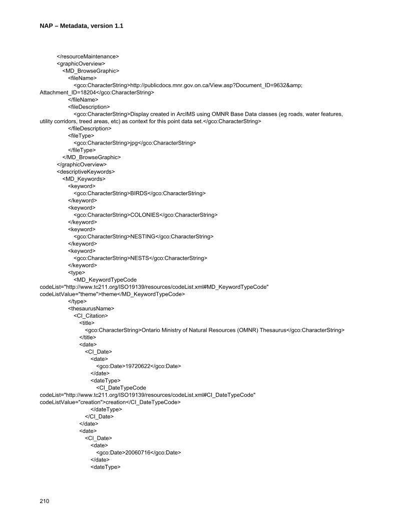
NAP – Metadata, version 1.1
210
</resourceMaintenance> <graphicOverview> <MD_BrowseGraphic> <fileName> <gco:CharacterString>http://publicdocs.mnr.gov.on.ca/View.asp?Document_ID=9632& Attachment_ID=18204</gco:CharacterString> </fileName> <fileDescription> <gco:CharacterString>Display created in ArcIMS using OMNR Base Data classes (eg roads, water features, utility corridors, treed areas, etc) as context for this point data set.</gco:CharacterString> </fileDescription> <fileType> <gco:CharacterString>jpg</gco:CharacterString> </fileType> </MD_BrowseGraphic> </graphicOverview> <descriptiveKeywords> <MD_Keywords> <keyword> <gco:CharacterString>BIRDS</gco:CharacterString> </keyword> <keyword> <gco:CharacterString>COLONIES</gco:CharacterString> </keyword> <keyword> <gco:CharacterString>NESTING</gco:CharacterString> </keyword> <keyword> <gco:CharacterString>NESTS</gco:CharacterString> </keyword> <type> <MD_KeywordTypeCode codeList="http://www.tc211.org/ISO19139/resources/codeList.xml#MD_KeywordTypeCode" codeListValue="theme">theme</MD_KeywordTypeCode> </type> <thesaurusName> <CI_Citation> <title> <gco:CharacterString>Ontario Ministry of Natural Resources (OMNR) Thesaurus</gco:CharacterString> </title> <date> <CI_Date> <date> <gco:Date>19720622</gco:Date> </date> <dateType> <CI_DateTypeCode codeList="http://www.tc211.org/ISO19139/resources/codeList.xml#CI_DateTypeCode" codeListValue="creation">creation</CI_DateTypeCode> </dateType> </CI_Date> </date> <date> <CI_Date> <date> <gco:Date>20060716</gco:Date> </date> <dateType>

NAP – Metadata, version 1.1
211
<CI_DateTypeCode codeList="http://www.tc211.org/ISO19139/resources/codeList.xml#CI_DateTypeCode" codeListValue="revision">revision</CI_DateTypeCode> </dateType> </CI_Date> </date> <edition> <gco:CharacterString>Originally created to catalogue documents stored in the OMNR library and since modified</gco:CharacterString> </edition> <citedResponsibleParty> <CI_ResponsibleParty> <organisationName> <gco:CharacterString>Ministry of Natural Resources</gco:CharacterString> </organisationName> <role> <CI_RoleCode codeList="http://www.tc211.org/ISO19139/resources/codeList.xml#CI_RoleCode" codeListValue="pointOfContact">pointOfContact</CI_RoleCode> </role> </CI_ResponsibleParty> </citedResponsibleParty> </CI_Citation> </thesaurusName> </MD_Keywords> </descriptiveKeywords> <descriptiveKeywords> <MD_Keywords> <keyword> <gco:CharacterString>FOREST MANAGEMENT</gco:CharacterString> </keyword> <keyword> <gco:CharacterString>FORESTRY</gco:CharacterString> </keyword> <keyword> <gco:CharacterString>LAND USE PLANNING</gco:CharacterString> </keyword> <keyword> <gco:CharacterString>MUNICIPAL PLANNING</gco:CharacterString> </keyword> <keyword> <gco:CharacterString>WILDLIFE</gco:CharacterString> </keyword> <type> <MD_KeywordTypeCode codeList="http://www.tc211.org/ISO19139/resources/codeList.xml#MD_KeywordTypeCode" codeListValue="discipline">discipline</MD_KeywordTypeCode> </type> <thesaurusName> <CI_Citation> <title> <gco:CharacterString>Ontario Ministry of Natural Resources (OMNR) Thesaurus</gco:CharacterString> </title> <date> <CI_Date> <date> <gco:Date>19720622</gco:Date> </date> <dateType>
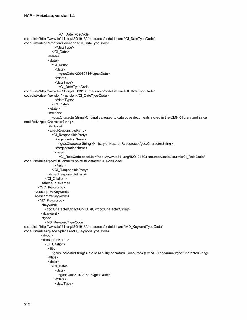
NAP – Metadata, version 1.1
212
<CI_DateTypeCode codeList="http://www.tc211.org/ISO19139/resources/codeList.xml#CI_DateTypeCode" codeListValue="creation">creation</CI_DateTypeCode> </dateType> </CI_Date> </date> <date> <CI_Date> <date> <gco:Date>20060716</gco:Date> </date> <dateType> <CI_DateTypeCode codeList="http://www.tc211.org/ISO19139/resources/codeList.xml#CI_DateTypeCode" codeListValue="revision">revision</CI_DateTypeCode> </dateType> </CI_Date> </date> <edition> <gco:CharacterString>Originally created to catalogue documents stored in the OMNR library and since modified.</gco:CharacterString> </edition> <citedResponsibleParty> <CI_ResponsibleParty> <organisationName> <gco:CharacterString>Ministry of Natural Resources</gco:CharacterString> </organisationName> <role> <CI_RoleCode codeList="http://www.tc211.org/ISO19139/resources/codeList.xml#CI_RoleCode" codeListValue="pointOfContact">pointOfContact</CI_RoleCode> </role> </CI_ResponsibleParty> </citedResponsibleParty> </CI_Citation> </thesaurusName> </MD_Keywords> </descriptiveKeywords> <descriptiveKeywords> <MD_Keywords> <keyword> <gco:CharacterString>ONTARIO</gco:CharacterString> </keyword> <type> <MD_KeywordTypeCode codeList="http://www.tc211.org/ISO19139/resources/codeList.xml#MD_KeywordTypeCode" codeListValue="place">place</MD_KeywordTypeCode> </type> <thesaurusName> <CI_Citation> <title> <gco:CharacterString>Ontario Ministry of Natural Resources (OMNR) Thesaurus</gco:CharacterString> </title> <date> <CI_Date> <date> <gco:Date>19720622</gco:Date> </date> <dateType>
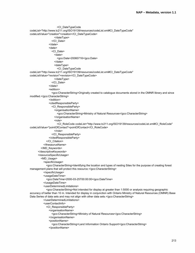
NAP – Metadata, version 1.1
213
<CI_DateTypeCode codeList="http://www.tc211.org/ISO19139/resources/codeList.xml#CI_DateTypeCode" codeListValue="creation">creation</CI_DateTypeCode> </dateType> </CI_Date> </date> <date> <CI_Date> <date> <gco:Date>20060716</gco:Date> </date> <dateType> <CI_DateTypeCode codeList="http://www.tc211.org/ISO19139/resources/codeList.xml#CI_DateTypeCode" codeListValue="revision">revision</CI_DateTypeCode> </dateType> </CI_Date> </date> <edition> <gco:CharacterString>Originally created to catalogue documents stored in the OMNR library and since modified.</gco:CharacterString> </edition> <citedResponsibleParty> <CI_ResponsibleParty> <organisationName> <gco:CharacterString>Ministry of Natural Resources</gco:CharacterString> </organisationName> <role> <CI_RoleCode codeList="http://www.tc211.org/ISO19139/resources/codeList.xml#CI_RoleCode" codeListValue="pointOfContact">pointOfContact</CI_RoleCode> </role> </CI_ResponsibleParty> </citedResponsibleParty> </CI_Citation> </thesaurusName> </MD_Keywords> </descriptiveKeywords> <resourceSpecificUsage> <MD_Usage> <specificUsage> <gco:CharacterString>Identifying the location and types of nesting Sites for the purpose of creating forest management plans that will protect this resource.</gco:CharacterString> </specificUsage> <usageDateTime> <gco:DateTime>2000-03-25T00:00:00</gco:DateTime> </usageDateTime> <userDeterminedLimitations> <gco:CharacterString>Not intended for display at greater than 1:5000 or analysis requiring geographic accuracy of better than 10 m. Intended for display in conjunction with Ontario Ministry of Natural Resources (OMNR) Base Data Series of data sets and may not align with other data sets.</gco:CharacterString> </userDeterminedLimitations> <userContactInfo> <CI_ResponsibleParty> <organisationName> <gco:CharacterString>Ministry of Natural Resources</gco:CharacterString> </organisationName> <positionName> <gco:CharacterString>Land Information Ontario Support</gco:CharacterString> </positionName>
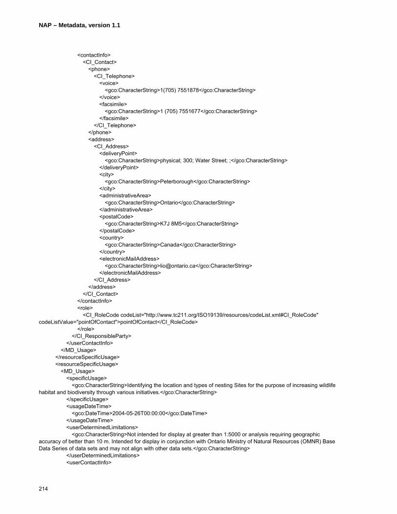
NAP – Metadata, version 1.1
214
<contactInfo> <CI_Contact> <phone> <CI_Telephone> <voice> <gco:CharacterString>1(705) 7551878</gco:CharacterString> </voice> <facsimile> <gco:CharacterString>1 (705) 7551677</gco:CharacterString> </facsimile> </CI_Telephone> </phone> <address> <CI_Address> <deliveryPoint> <gco:CharacterString>physical; 300; Water Street; ;</gco:CharacterString> </deliveryPoint> <city> <gco:CharacterString>Peterborough</gco:CharacterString> </city> <administrativeArea> <gco:CharacterString>Ontario</gco:CharacterString> </administrativeArea> <postalCode> <gco:CharacterString>K7J 8M5</gco:CharacterString> </postalCode> <country> <gco:CharacterString>Canada</gco:CharacterString> </country> <electronicMailAddress> <gco:CharacterString>[email protected]</gco:CharacterString> </electronicMailAddress> </CI_Address> </address> </CI_Contact> </contactInfo> <role> <CI_RoleCode codeList="http://www.tc211.org/ISO19139/resources/codeList.xml#CI_RoleCode" codeListValue="pointOfContact">pointOfContact</CI_RoleCode> </role> </CI_ResponsibleParty> </userContactInfo> </MD_Usage> </resourceSpecificUsage> <resourceSpecificUsage> <MD_Usage> <specificUsage> <gco:CharacterString>Identifying the location and types of nesting Sites for the purpose of increasing wildlife habitat and biodiversity through various initiatives.</gco:CharacterString> </specificUsage> <usageDateTime> <gco:DateTime>2004-05-26T00:00:00</gco:DateTime> </usageDateTime> <userDeterminedLimitations> <gco:CharacterString>Not intended for display at greater than 1:5000 or analysis requiring geographic accuracy of better than 10 m. Intended for display in conjunction with Ontario Ministry of Natural Resources (OMNR) Base Data Series of data sets and may not align with other data sets.</gco:CharacterString> </userDeterminedLimitations> <userContactInfo>
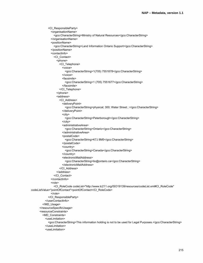
NAP – Metadata, version 1.1
215
<CI_ResponsibleParty> <organisationName> <gco:CharacterString>Ministry of Natural Resources</gco:CharacterString> </organisationName> <positionName> <gco:CharacterString>Land Information Ontario Support</gco:CharacterString> </positionName> <contactInfo> <CI_Contact> <phone> <CI_Telephone> <voice> <gco:CharacterString>1(705) 7551878</gco:CharacterString> </voice> <facsimile> <gco:CharacterString>1 (705) 7551677</gco:CharacterString> </facsimile> </CI_Telephone> </phone> <address> <CI_Address> <deliveryPoint> <gco:CharacterString>physical; 300; Water Street; ;</gco:CharacterString> </deliveryPoint> <city> <gco:CharacterString>Peterborough</gco:CharacterString> </city> <administrativeArea> <gco:CharacterString>Ontario</gco:CharacterString> </administrativeArea> <postalCode> <gco:CharacterString>K7J 8M5</gco:CharacterString> </postalCode> <country> <gco:CharacterString>Canada</gco:CharacterString> </country> <electronicMailAddress> <gco:CharacterString>[email protected]</gco:CharacterString> </electronicMailAddress> </CI_Address> </address> </CI_Contact> </contactInfo> <role> <CI_RoleCode codeList="http://www.tc211.org/ISO19139/resources/codeList.xml#CI_RoleCode" codeListValue="pointOfContact">pointOfContact</CI_RoleCode> </role> </CI_ResponsibleParty> </userContactInfo> </MD_Usage> </resourceSpecificUsage> <resourceConstraints> <MD_Constraints> <useLimitation> <gco:CharacterString>This information holding is not to be used for Legal Purposes.</gco:CharacterString> </useLimitation> <useLimitation>
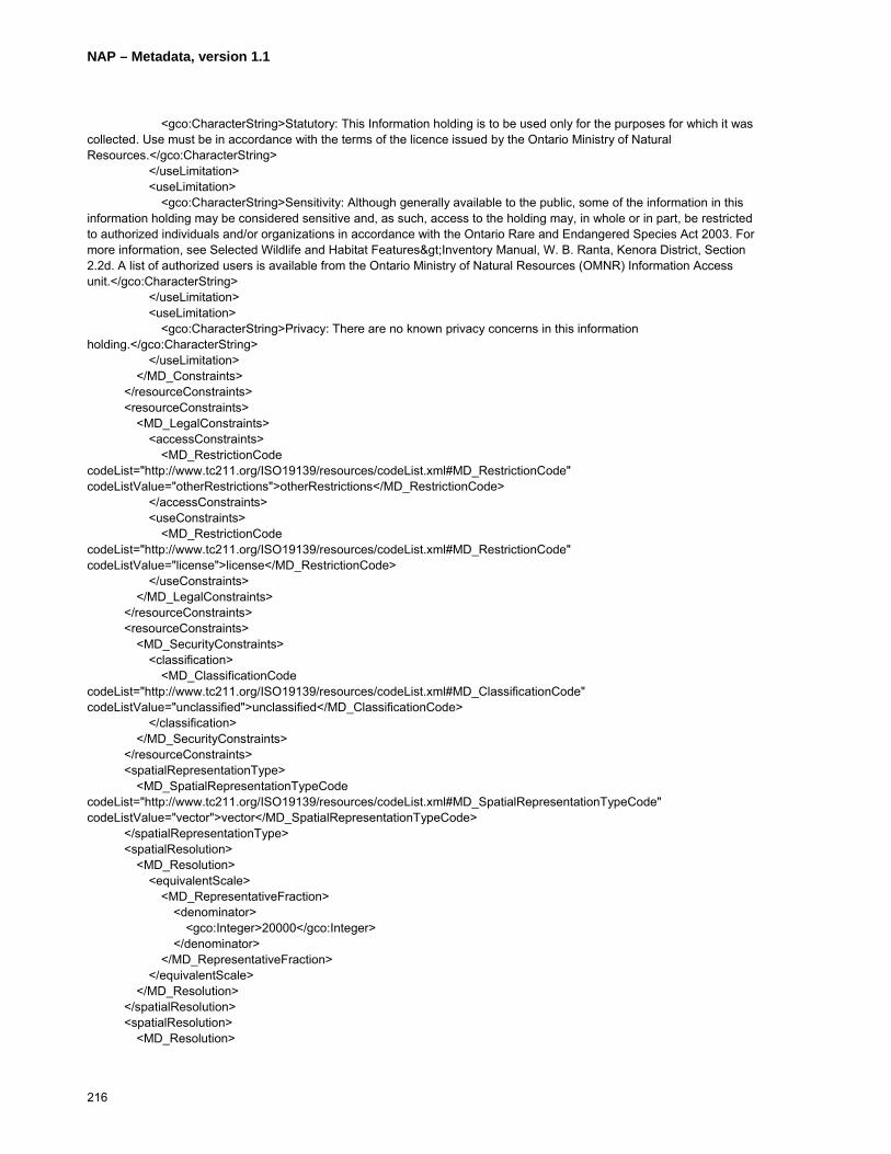
NAP – Metadata, version 1.1
216
<gco:CharacterString>Statutory: This Information holding is to be used only for the purposes for which it was collected. Use must be in accordance with the terms of the licence issued by the Ontario Ministry of Natural Resources.</gco:CharacterString> </useLimitation> <useLimitation> <gco:CharacterString>Sensitivity: Although generally available to the public, some of the information in this information holding may be considered sensitive and, as such, access to the holding may, in whole or in part, be restricted to authorized individuals and/or organizations in accordance with the Ontario Rare and Endangered Species Act 2003. For more information, see Selected Wildlife and Habitat Features>Inventory Manual, W. B. Ranta, Kenora District, Section 2.2d. A list of authorized users is available from the Ontario Ministry of Natural Resources (OMNR) Information Access unit.</gco:CharacterString> </useLimitation> <useLimitation> <gco:CharacterString>Privacy: There are no known privacy concerns in this information holding.</gco:CharacterString> </useLimitation> </MD_Constraints> </resourceConstraints> <resourceConstraints> <MD_LegalConstraints> <accessConstraints> <MD_RestrictionCode codeList="http://www.tc211.org/ISO19139/resources/codeList.xml#MD_RestrictionCode" codeListValue="otherRestrictions">otherRestrictions</MD_RestrictionCode> </accessConstraints> <useConstraints> <MD_RestrictionCode codeList="http://www.tc211.org/ISO19139/resources/codeList.xml#MD_RestrictionCode" codeListValue="license">license</MD_RestrictionCode> </useConstraints> </MD_LegalConstraints> </resourceConstraints> <resourceConstraints> <MD_SecurityConstraints> <classification> <MD_ClassificationCode codeList="http://www.tc211.org/ISO19139/resources/codeList.xml#MD_ClassificationCode" codeListValue="unclassified">unclassified</MD_ClassificationCode> </classification> </MD_SecurityConstraints> </resourceConstraints> <spatialRepresentationType> <MD_SpatialRepresentationTypeCode codeList="http://www.tc211.org/ISO19139/resources/codeList.xml#MD_SpatialRepresentationTypeCode" codeListValue="vector">vector</MD_SpatialRepresentationTypeCode> </spatialRepresentationType> <spatialResolution> <MD_Resolution> <equivalentScale> <MD_RepresentativeFraction> <denominator> <gco:Integer>20000</gco:Integer> </denominator> </MD_RepresentativeFraction> </equivalentScale> </MD_Resolution> </spatialResolution> <spatialResolution> <MD_Resolution>

NAP – Metadata, version 1.1
217
<distance> <gco:Distance uom="metre">10</gco:Distance> </distance> </MD_Resolution> </spatialResolution> <language> <gco:CharacterString>eng</gco:CharacterString> </language> <language> <gco:CharacterString>fra</gco:CharacterString> </language> <language> <gco:CharacterString>cre</gco:CharacterString> </language> <characterSet> <MD_CharacterSetCode codeList="http://www.tc211.org/ISO19139/resources/codeList.xml#MD_CharacterSetCode" codeListValue="utf8">utf8</MD_CharacterSetCode> </characterSet> <topicCategory> <MD_TopicCategoryCode>biota</MD_TopicCategoryCode> </topicCategory> <environmentDescription> <gco:CharacterString>Spatial locations and attributes are maintained by the OMNR's Natural Resources Values Information System (NRVIS), a custom instance of ESRI ArcGIS 9.x supported by Oracle DBMS</gco:CharacterString> </environmentDescription> <extent> <EX_Extent> <geographicElement> <EX_BoundingPolygon> <extentTypeCode> <gco:Boolean>1</gco:Boolean> </extentTypeCode> <polygon/> </EX_BoundingPolygon> </geographicElement> <geographicElement> <EX_GeographicBoundingBox> <extentTypeCode> <gco:Boolean>1</gco:Boolean> </extentTypeCode> <westBoundLongitude> <gco:Decimal>-95.9</gco:Decimal> </westBoundLongitude> <eastBoundLongitude> <gco:Decimal>-74.18</gco:Decimal> </eastBoundLongitude> <southBoundLatitude> <gco:Decimal>41.4</gco:Decimal> </southBoundLatitude> <northBoundLatitude> <gco:Decimal>56.5</gco:Decimal> </northBoundLatitude> </EX_GeographicBoundingBox> </geographicElement> </EX_Extent> </extent> </MD_DataIdentification> </identificationInfo>
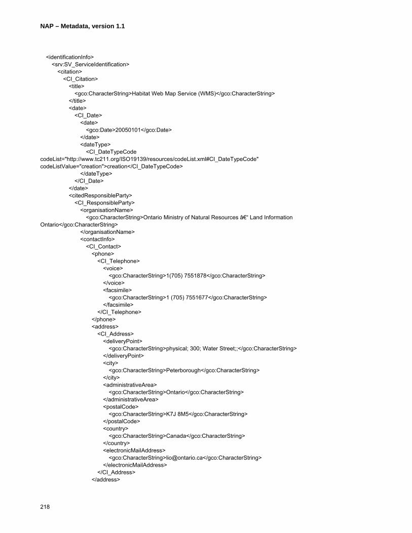
NAP – Metadata, version 1.1
218
<identificationInfo> <srv:SV_ServiceIdentification> <citation> <CI_Citation> <title> <gco:CharacterString>Habitat Web Map Service (WMS)</gco:CharacterString> </title> <date> <CI_Date> <date> <gco:Date>20050101</gco:Date> </date> <dateType> <CI_DateTypeCode codeList="http://www.tc211.org/ISO19139/resources/codeList.xml#CI_DateTypeCode" codeListValue="creation">creation</CI_DateTypeCode> </dateType> </CI_Date> </date> <citedResponsibleParty> <CI_ResponsibleParty> <organisationName> <gco:CharacterString>Ontario Ministry of Natural Resources – Land Information Ontario</gco:CharacterString> </organisationName> <contactInfo> <CI_Contact> <phone> <CI_Telephone> <voice> <gco:CharacterString>1(705) 7551878</gco:CharacterString> </voice> <facsimile> <gco:CharacterString>1 (705) 7551677</gco:CharacterString> </facsimile> </CI_Telephone> </phone> <address> <CI_Address> <deliveryPoint> <gco:CharacterString>physical; 300; Water Street;;</gco:CharacterString> </deliveryPoint> <city> <gco:CharacterString>Peterborough</gco:CharacterString> </city> <administrativeArea> <gco:CharacterString>Ontario</gco:CharacterString> </administrativeArea> <postalCode> <gco:CharacterString>K7J 8M5</gco:CharacterString> </postalCode> <country> <gco:CharacterString>Canada</gco:CharacterString> </country> <electronicMailAddress> <gco:CharacterString>[email protected]</gco:CharacterString> </electronicMailAddress> </CI_Address> </address>
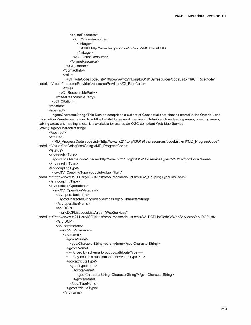
NAP – Metadata, version 1.1
219
<onlineResource> <CI_OnlineResource> <linkage> <URL>http://www.lio.gov.on.ca/en/ws_WMS.htm</URL> </linkage> </CI_OnlineResource> </onlineResource> </CI_Contact> </contactInfo> <role> <CI_RoleCode codeList="http://www.tc211.org/ISO19139/resources/codeList.xml#CI_RoleCode" codeListValue="resourceProvider">resourceProvider</CI_RoleCode> </role> </CI_ResponsibleParty> </citedResponsibleParty> </CI_Citation> </citation> <abstract> <gco:CharacterString>This Service comprises a subset of Geospatial data classes stored in the Ontario Land Information Warehouse related to wildlife habitat for several species in Ontario such as feeding areas, breeding areas, calving areas and nesting sites. It is available for use as an OGC-compliant Web Map Service (WMS).</gco:CharacterString> </abstract> <status> <MD_ProgressCode codeList="http://www.tc211.org/ISO19139/resources/codeList.xml#MD_ProgressCode" codeListValue="onGoing">onGoing</MD_ProgressCode> </status> <srv:serviceType> <gco:LocalName codeSpace="http://www.tc211.org/ISO19119/serviceTypes">WMS</gco:LocalName> </srv:serviceType> <srv:couplingType> <srv:SV_CouplingType codeListValue="tight" codeList="http://www.tc211.org/ISO19119/resources/codeList.xml#SV_CouplingTypeListCode"/> </srv:couplingType> <srv:containsOperations> <srv:SV_OperationMetadata> <srv:operationName> <gco:CharacterString>webServices</gco:CharacterString> </srv:operationName> <srv:DCP> <srv:DCPList codeListValue="WebServices" codeList="http://www.tc211.org/ISO19119/resources/codeList.xml#SV_DCPListCode">WebServices</srv:DCPList> </srv:DCP> <srv:parameters> <srv:SV_Parameter> <srv:name> <gco:aName> <gco:CharacterString>paramName</gco:CharacterString> </gco:aName> <!-- forced by schema to put gco:attributeType --> <!-- may be it is a duplication of srv:valueType ? --> <gco:attributeType> <gco:TypeName> <gco:aName> <gco:CharacterString>CharacterString?</gco:CharacterString> </gco:aName> </gco:TypeName> </gco:attributeType> </srv:name>

NAP – Metadata, version 1.1
220
<srv:optionality> <gco:CharacterString>Mandatory</gco:CharacterString> </srv:optionality> <srv:repeatability> <gco:Boolean>false</gco:Boolean> </srv:repeatability> <srv:valueType> <gco:TypeName> <gco:aName> <gco:CharacterString>CharacterString</gco:CharacterString> </gco:aName> </gco:TypeName> </srv:valueType> </srv:SV_Parameter> </srv:parameters> <srv:connectPoint> <CI_OnlineResource> <linkage> <URL>http://lioapp.lrc.gov.on.ca/LioOgcWms21/lioogcwmsserver/wms_habitat?version=1.1.1& request=GetCapabilities&service=WMS</URL> </linkage> <protocol> <gco:CharacterString>http</gco:CharacterString> </protocol> </CI_OnlineResource> </srv:connectPoint> </srv:SV_OperationMetadata> </srv:containsOperations> </srv:SV_ServiceIdentification> </identificationInfo> <contentInfo> <MD_FeatureCatalogueDescription> <complianceCode> <gco:Boolean>false</gco:Boolean> </complianceCode> <language> <gco:CharacterString>eng; CAN; utf8</gco:CharacterString> </language> <includedWithDataset> <gco:Boolean>false</gco:Boolean> </includedWithDataset> <featureTypes> <gco:LocalName>1015 Bald Eagle Nesting Site</gco:LocalName> </featureTypes> <featureTypes> <gco:LocalName>1037 Caspian Tern Nesting Site</gco:LocalName> </featureTypes> <featureTypes> <gco:LocalName>1042 Common Barn Owl Nesting Site</gco:LocalName> </featureTypes> <featureTypes> <gco:LocalName>1049 Cooper's Hawk Nesting Site</gco:LocalName> </featureTypes> <featureTypes> <gco:LocalName>1069 Eastern Bluebird Nesting Site</gco:LocalName> </featureTypes> <featureTypes> <gco:LocalName>1130 Loggerhead Shrike Nesting Site</gco:LocalName> </featureTypes>
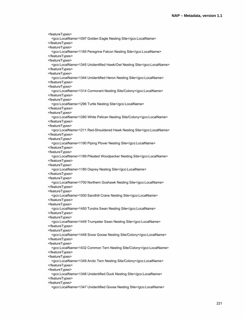
NAP – Metadata, version 1.1
221
<featureTypes> <gco:LocalName>1097 Golden Eagle Nesting Site</gco:LocalName> </featureTypes> <featureTypes> <gco:LocalName>1185 Peregrine Falcon Nesting Site</gco:LocalName> </featureTypes> <featureTypes> <gco:LocalName>1345 Unidentified Hawk/Owl Nesting Site</gco:LocalName> </featureTypes> <featureTypes> <gco:LocalName>1344 Unidentified Heron Nesting Site</gco:LocalName> </featureTypes> <featureTypes> <gco:LocalName>1314 Cormorant Nesting Site/Colony</gco:LocalName> </featureTypes> <featureTypes> <gco:LocalName>1296 Turtle Nesting Site</gco:LocalName> </featureTypes> <featureTypes> <gco:LocalName>1280 White Pelican Nesting Site/Colony</gco:LocalName> </featureTypes> <featureTypes> <gco:LocalName>1211 Red-Shouldered Hawk Nesting Site</gco:LocalName> </featureTypes> <featureTypes> <gco:LocalName>1190 Piping Plover Nesting Site</gco:LocalName> </featureTypes> <featureTypes> <gco:LocalName>1189 Pileated Woodpecker Nesting Site</gco:LocalName> </featureTypes> <featureTypes> <gco:LocalName>1180 Osprey Nesting Site</gco:LocalName> </featureTypes> <featureTypes> <gco:LocalName>1700 Northern Goshawk Nesting Site</gco:LocalName> </featureTypes> <featureTypes> <gco:LocalName>1500 Sandhill Crane Nesting Site</gco:LocalName> </featureTypes> <featureTypes> <gco:LocalName>1450 Tundra Swan Nesting Site</gco:LocalName> </featureTypes> <featureTypes> <gco:LocalName>1449 Trumpeter Swan Nesting Site</gco:LocalName> </featureTypes> <featureTypes> <gco:LocalName>1448 Snow Goose Nesting Site/Colony</gco:LocalName> </featureTypes> <featureTypes> <gco:LocalName>1432 Common Tern Nesting Site/Colony</gco:LocalName> </featureTypes> <featureTypes> <gco:LocalName>1349 Arctic Tern Nesting Site/Colony</gco:LocalName> </featureTypes> <featureTypes> <gco:LocalName>1348 Unidentified Duck Nesting Site</gco:LocalName> </featureTypes> <featureTypes> <gco:LocalName>1347 Unidentified Goose Nesting Site</gco:LocalName>
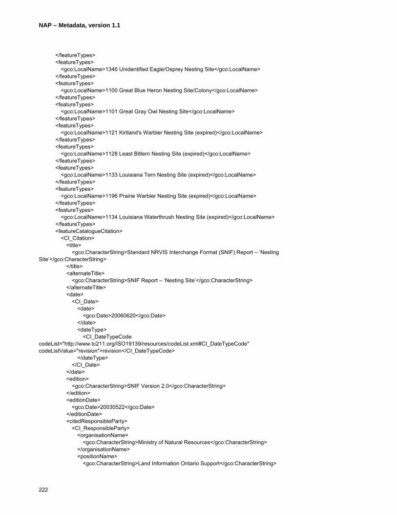
NAP – Metadata, version 1.1
222
</featureTypes> <featureTypes> <gco:LocalName>1346 Unidentified Eagle/Osprey Nesting Site</gco:LocalName> </featureTypes> <featureTypes> <gco:LocalName>1100 Great Blue Heron Nesting Site/Colony</gco:LocalName> </featureTypes> <featureTypes> <gco:LocalName>1101 Great Gray Owl Nesting Site</gco:LocalName> </featureTypes> <featureTypes> <gco:LocalName>1121 Kirtland's Warbler Nesting Site (expired)</gco:LocalName> </featureTypes> <featureTypes> <gco:LocalName>1128 Least Bittern Nesting Site (expired)</gco:LocalName> </featureTypes> <featureTypes> <gco:LocalName>1133 Louisiana Tern Nesting Site (expired)</gco:LocalName> </featureTypes> <featureTypes> <gco:LocalName>1196 Prairie Warbler Nesting Site (expired)</gco:LocalName> </featureTypes> <featureTypes> <gco:LocalName>1134 Louisiana Waterthrush Nesting Site (expired)</gco:LocalName> </featureTypes> <featureCatalogueCitation> <CI_Citation> <title> <gco:CharacterString>Standard NRVIS Interchange Format (SNIF) Report – ‘Nesting Site’</gco:CharacterString> </title> <alternateTitle> <gco:CharacterString>SNIF Report – ‘Nesting Site’</gco:CharacterString> </alternateTitle> <date> <CI_Date> <date> <gco:Date>20060620</gco:Date> </date> <dateType> <CI_DateTypeCode codeList="http://www.tc211.org/ISO19139/resources/codeList.xml#CI_DateTypeCode" codeListValue="revision">revision</CI_DateTypeCode> </dateType> </CI_Date> </date> <edition> <gco:CharacterString>SNIF Version 2.0</gco:CharacterString> </edition> <editionDate> <gco:Date>20030522</gco:Date> </editionDate> <citedResponsibleParty> <CI_ResponsibleParty> <organisationName> <gco:CharacterString>Ministry of Natural Resources</gco:CharacterString> </organisationName> <positionName> <gco:CharacterString>Land Information Ontario Support</gco:CharacterString>

NAP – Metadata, version 1.1
223
</positionName> <contactInfo> <CI_Contact> <phone> <CI_Telephone> <voice> <gco:CharacterString>1 (705) 7551878</gco:CharacterString> </voice> <facsimile> <gco:CharacterString>1 (705) 7551677</gco:CharacterString> </facsimile> </CI_Telephone> </phone> <address> <CI_Address> <deliveryPoint> <gco:CharacterString>physical; 300; Water Street; ;</gco:CharacterString> </deliveryPoint> <city> <gco:CharacterString>Peterborough</gco:CharacterString> </city> <administrativeArea> <gco:CharacterString>Ontario</gco:CharacterString> </administrativeArea> <postalCode> <gco:CharacterString>K7J 8M5</gco:CharacterString> </postalCode> <country> <gco:CharacterString>Canada</gco:CharacterString> </country> <electronicMailAddress> <gco:CharacterString>[email protected]</gco:CharacterString> </electronicMailAddress> </CI_Address> </address> <onlineResource> <CI_OnlineResource> <linkage> <URL>http://publicdocs.mnr.gov.on.ca/View.asp?Document_ID=8874& Attachment_ID=16787</URL> </linkage> <description> <gco:CharacterString>Detailed description of data dictionary and data model.</gco:CharacterString> </description> </CI_OnlineResource> </onlineResource> </CI_Contact> </contactInfo> <role> <CI_RoleCode codeList="http://www.tc211.org/ISO19139/resources/codeList.xml#CI_RoleCode" codeListValue="pointOfContact">pointOfContact</CI_RoleCode> </role> </CI_ResponsibleParty> </citedResponsibleParty> </CI_Citation> </featureCatalogueCitation> </MD_FeatureCatalogueDescription> </contentInfo>

NAP – Metadata, version 1.1
224
<distributionInfo> <MD_Distribution> <distributionFormat> <MD_Format> <name> <gco:CharacterString>ESRI ARC/INFO Coverage</gco:CharacterString> </name> <version> <gco:CharacterString>ArcGIS 8.3</gco:CharacterString> </version> </MD_Format> </distributionFormat> <distributionFormat> <MD_Format> <name> <gco:CharacterString>ESRI Shapefile</gco:CharacterString> </name> <version> <gco:CharacterString>ArcGIS 8.3</gco:CharacterString> </version> </MD_Format> </distributionFormat> <distributionFormat> <MD_Format> <name> <gco:CharacterString>ESRI ARC/INFO Export (.e00)</gco:CharacterString> </name> <version> <gco:CharacterString>ArcGIS 8.3</gco:CharacterString> </version> </MD_Format> </distributionFormat> <distributionFormat> <MD_Format> <name> <gco:CharacterString>MNR NRVIS-Lite</gco:CharacterString> </name> <version> <gco:CharacterString>2.1</gco:CharacterString> </version> </MD_Format> </distributionFormat> <distributor> <MD_Distributor> <distributorContact> <CI_ResponsibleParty> <contactInfo> <CI_Contact> <phone> <CI_Telephone> <voice> <gco:CharacterString>1 (705) 7551878</gco:CharacterString> </voice> <facsimile> <gco:CharacterString>1 (705) 7551677</gco:CharacterString> </facsimile> </CI_Telephone> </phone> <address>

NAP – Metadata, version 1.1
225
<CI_Address> <deliveryPoint> <gco:CharacterString>physical; 300; Water Street; ;</gco:CharacterString> </deliveryPoint> <city> <gco:CharacterString>Peterborough</gco:CharacterString> </city> <administrativeArea> <gco:CharacterString>Ontario</gco:CharacterString> </administrativeArea> <postalCode> <gco:CharacterString>K7J 8M5</gco:CharacterString> </postalCode> <country> <gco:CharacterString>Canada</gco:CharacterString> </country> <electronicMailAddress> <gco:CharacterString>[email protected]</gco:CharacterString> </electronicMailAddress> </CI_Address> </address> </CI_Contact> </contactInfo> <role> <CI_RoleCode codeList="http://www.tc211.org/ISO19139/resources/codeList.xml#CI_RoleCode" codeListValue="distributor">distributor</CI_RoleCode> </role> </CI_ResponsibleParty> </distributorContact> </MD_Distributor> </distributor> <transferOptions> <MD_DigitalTransferOptions> <offLine> <MD_Medium> <name> <MD_MediumNameCode codeList="http://www.tc211.org/ISO19139/resources/codeList.xml#MD_MediumNameCode" codeListValue="cdRom">cdRom</MD_MediumNameCode> </name> </MD_Medium> </offLine> </MD_DigitalTransferOptions> </transferOptions> <transferOptions> <MD_DigitalTransferOptions> <offLine> <MD_Medium> <name> <MD_MediumNameCode codeList="http://www.tc211.org/ISO19139/resources/codeList.xml#MD_MediumNameCode" codeListValue="dvdRom">dvdRom</MD_MediumNameCode> </name> </MD_Medium> </offLine> </MD_DigitalTransferOptions> </transferOptions> </MD_Distribution> </distributionInfo>

NAP – Metadata, version 1.1
226
<dataQualityInfo> <DQ_DataQuality> <scope> <DQ_Scope> <level> <MD_ScopeCode codeList="http://www.tc211.org/ISO19139/resources/codeList.xml#MD_ScopeCode" codeListValue="series">series</MD_ScopeCode> </level> </DQ_Scope> </scope> <lineage> <LI_Lineage> <statement> <gco:CharacterString>Data is collected and maintained by Ontario Ministry of Natural Resources (OMNR) Districts using the Natural Resources Values Information System (NRVIS).</gco:CharacterString> </statement> <processStep> <LI_ProcessStep> <description> <gco:CharacterString>Investigation by OMNR staff biologists via GPS and remote GIS devices both on the ground and by helicopter.</gco:CharacterString> </description> <rationale> <gco:CharacterString>Periodic update</gco:CharacterString> </rationale> <dateTime> <gco:DateTime>2006-04-15T00:00:00</gco:DateTime> </dateTime> </LI_ProcessStep> </processStep> <source> <LI_Source> <description> <gco:CharacterString>The Nesting Site data was compiled from various sources including direct collection by Ontario Ministry of Natural Resources (OMNR) biologists via GPS and in some cases sketches based on observations. Some of the data may have been taken from vintage Ontario Base Maps (circa 1972-1985). The Nesting Site data class is a point class and should be used with one or more OMNR Base Data classes in order to provide an appropriate relative geographic reference.</gco:CharacterString> </description> </LI_Source> </source> </LI_Lineage> </lineage> </DQ_DataQuality> </dataQualityInfo> <metadataMaintenance> <MD_MaintenanceInformation> <maintenanceAndUpdateFrequency> <MD_MaintenanceFrequencyCode codeList="http://www.tc211.org/ISO19139/resources/codeList.xml#MD_MaintenanceFrequencyCode" codeListValue="annually">annually</MD_MaintenanceFrequencyCode> </maintenanceAndUpdateFrequency> <dateOfNextUpdate> <gco:Date>20070415</gco:Date> </dateOfNextUpdate> <updateScope> <MD_ScopeCode codeList="http://www.tc211.org/ISO19139/resources/codeList.xml#MD_ScopeCode" codeListValue="series">series</MD_ScopeCode> </updateScope>

NAP – Metadata, version 1.1
227
<updateScopeDescription> <MD_ScopeDescription> <dataset> <gco:CharacterString>Update activity checks for changes to any aspect of the dataset and modifies the Metadata record accordingly.</gco:CharacterString> </dataset> </MD_ScopeDescription> </updateScopeDescription> <contact> <CI_ResponsibleParty> <organisationName> <gco:CharacterString>Ontario Ministry of Natural Resources</gco:CharacterString> </organisationName> <positionName> <gco:CharacterString>Land Information Ontario Support</gco:CharacterString> </positionName> <contactInfo> <CI_Contact> <phone> <CI_Telephone> <voice> <gco:CharacterString>1 (705) 7551878</gco:CharacterString> </voice> <facsimile> <gco:CharacterString>1 (705) 7551677</gco:CharacterString> </facsimile> </CI_Telephone> </phone> <address> <CI_Address> <deliveryPoint> <gco:CharacterString>physical; 300; Water Street; ;</gco:CharacterString> </deliveryPoint> <city> <gco:CharacterString>Peterborough</gco:CharacterString> </city> <administrativeArea> <gco:CharacterString>Ontario</gco:CharacterString> </administrativeArea> <postalCode> <gco:CharacterString>K7J 8M5</gco:CharacterString> </postalCode> <country> <gco:CharacterString>Canada</gco:CharacterString> </country> <electronicMailAddress> <gco:CharacterString>[email protected]</gco:CharacterString> </electronicMailAddress> </CI_Address> </address> </CI_Contact> </contactInfo> <role> <CI_RoleCode codeList="http://www.tc211.org/ISO19139/resources/codeList.xml#CI_RoleCode" codeListValue="custodian">custodian</CI_RoleCode> </role> </CI_ResponsibleParty> </contact> </MD_MaintenanceInformation>

NAP – Metadata, version 1.1
228
</metadataMaintenance> </MD_Metadata>
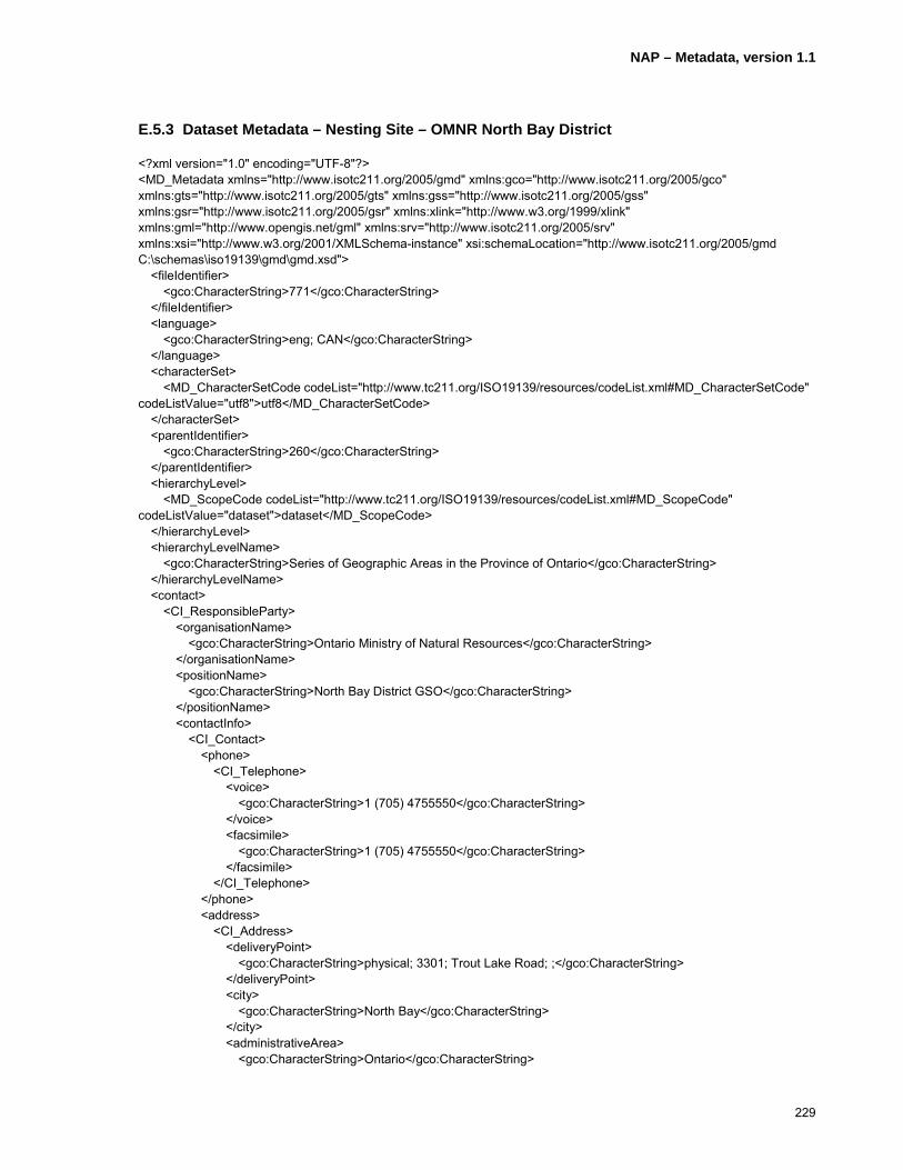
NAP – Metadata, version 1.1
229
E.5.3 Dataset Metadata – Nesting Site – OMNR North Bay District
<?xml version="1.0" encoding="UTF-8"?> <MD_Metadata xmlns="http://www.isotc211.org/2005/gmd" xmlns:gco="http://www.isotc211.org/2005/gco" xmlns:gts="http://www.isotc211.org/2005/gts" xmlns:gss="http://www.isotc211.org/2005/gss" xmlns:gsr="http://www.isotc211.org/2005/gsr" xmlns:xlink="http://www.w3.org/1999/xlink" xmlns:gml="http://www.opengis.net/gml" xmlns:srv="http://www.isotc211.org/2005/srv" xmlns:xsi="http://www.w3.org/2001/XMLSchema-instance" xsi:schemaLocation="http://www.isotc211.org/2005/gmd C:\schemas\iso19139\gmd\gmd.xsd"> <fileIdentifier> <gco:CharacterString>771</gco:CharacterString> </fileIdentifier> <language> <gco:CharacterString>eng; CAN</gco:CharacterString> </language> <characterSet> <MD_CharacterSetCode codeList="http://www.tc211.org/ISO19139/resources/codeList.xml#MD_CharacterSetCode" codeListValue="utf8">utf8</MD_CharacterSetCode> </characterSet> <parentIdentifier> <gco:CharacterString>260</gco:CharacterString> </parentIdentifier> <hierarchyLevel> <MD_ScopeCode codeList="http://www.tc211.org/ISO19139/resources/codeList.xml#MD_ScopeCode" codeListValue="dataset">dataset</MD_ScopeCode> </hierarchyLevel> <hierarchyLevelName> <gco:CharacterString>Series of Geographic Areas in the Province of Ontario</gco:CharacterString> </hierarchyLevelName> <contact> <CI_ResponsibleParty> <organisationName> <gco:CharacterString>Ontario Ministry of Natural Resources</gco:CharacterString> </organisationName> <positionName> <gco:CharacterString>North Bay District GSO</gco:CharacterString> </positionName> <contactInfo> <CI_Contact> <phone> <CI_Telephone> <voice> <gco:CharacterString>1 (705) 4755550</gco:CharacterString> </voice> <facsimile> <gco:CharacterString>1 (705) 4755550</gco:CharacterString> </facsimile> </CI_Telephone> </phone> <address> <CI_Address> <deliveryPoint> <gco:CharacterString>physical; 3301; Trout Lake Road; ;</gco:CharacterString> </deliveryPoint> <city> <gco:CharacterString>North Bay</gco:CharacterString> </city> <administrativeArea> <gco:CharacterString>Ontario</gco:CharacterString>
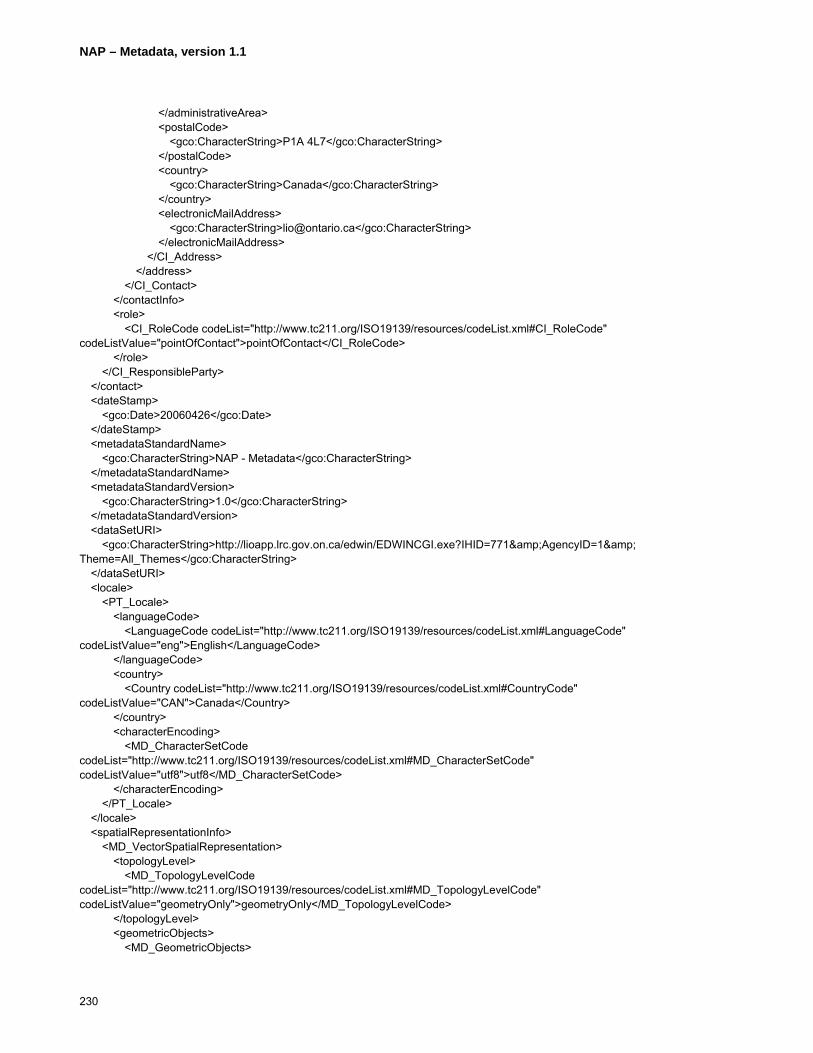
NAP – Metadata, version 1.1
230
</administrativeArea> <postalCode> <gco:CharacterString>P1A 4L7</gco:CharacterString> </postalCode> <country> <gco:CharacterString>Canada</gco:CharacterString> </country> <electronicMailAddress> <gco:CharacterString>[email protected]</gco:CharacterString> </electronicMailAddress> </CI_Address> </address> </CI_Contact> </contactInfo> <role> <CI_RoleCode codeList="http://www.tc211.org/ISO19139/resources/codeList.xml#CI_RoleCode" codeListValue="pointOfContact">pointOfContact</CI_RoleCode> </role> </CI_ResponsibleParty> </contact> <dateStamp> <gco:Date>20060426</gco:Date> </dateStamp> <metadataStandardName> <gco:CharacterString>NAP - Metadata</gco:CharacterString> </metadataStandardName> <metadataStandardVersion> <gco:CharacterString>1.0</gco:CharacterString> </metadataStandardVersion> <dataSetURI> <gco:CharacterString>http://lioapp.lrc.gov.on.ca/edwin/EDWINCGI.exe?IHID=771&AgencyID=1& Theme=All_Themes</gco:CharacterString> </dataSetURI> <locale> <PT_Locale> <languageCode> <LanguageCode codeList="http://www.tc211.org/ISO19139/resources/codeList.xml#LanguageCode" codeListValue="eng">English</LanguageCode> </languageCode> <country> <Country codeList="http://www.tc211.org/ISO19139/resources/codeList.xml#CountryCode" codeListValue="CAN">Canada</Country> </country> <characterEncoding> <MD_CharacterSetCode codeList="http://www.tc211.org/ISO19139/resources/codeList.xml#MD_CharacterSetCode" codeListValue="utf8">utf8</MD_CharacterSetCode> </characterEncoding> </PT_Locale> </locale> <spatialRepresentationInfo> <MD_VectorSpatialRepresentation> <topologyLevel> <MD_TopologyLevelCode codeList="http://www.tc211.org/ISO19139/resources/codeList.xml#MD_TopologyLevelCode" codeListValue="geometryOnly">geometryOnly</MD_TopologyLevelCode> </topologyLevel> <geometricObjects> <MD_GeometricObjects>
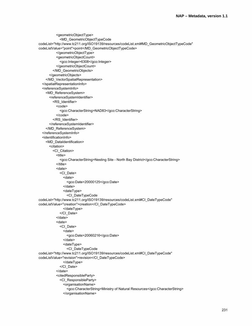
NAP – Metadata, version 1.1
231
<geometricObjectType> <MD_GeometricObjectTypeCode codeList="http://www.tc211.org/ISO19139/resources/codeList.xml#MD_GeometricObjectTypeCode" codeListValue="point">point</MD_GeometricObjectTypeCode> </geometricObjectType> <geometricObjectCount> <gco:Integer>6308</gco:Integer> </geometricObjectCount> </MD_GeometricObjects> </geometricObjects> </MD_VectorSpatialRepresentation> </spatialRepresentationInfo> <referenceSystemInfo> <MD_ReferenceSystem> <referenceSystemIdentifier> <RS_Identifier> <code> <gco:CharacterString>NAD83</gco:CharacterString> </code> </RS_Identifier> </referenceSystemIdentifier> </MD_ReferenceSystem> </referenceSystemInfo> <identificationInfo> <MD_DataIdentification> <citation> <CI_Citation> <title> <gco:CharacterString>Nesting Site - North Bay District</gco:CharacterString> </title> <date> <CI_Date> <date> <gco:Date>20000125</gco:Date> </date> <dateType> <CI_DateTypeCode codeList="http://www.tc211.org/ISO19139/resources/codeList.xml#CI_DateTypeCode" codeListValue="creation">creation</CI_DateTypeCode> </dateType> </CI_Date> </date> <date> <CI_Date> <date> <gco:Date>20060216</gco:Date> </date> <dateType> <CI_DateTypeCode codeList="http://www.tc211.org/ISO19139/resources/codeList.xml#CI_DateTypeCode" codeListValue="revision">revision</CI_DateTypeCode> </dateType> </CI_Date> </date> <citedResponsibleParty> <CI_ResponsibleParty> <organisationName> <gco:CharacterString>Ministry of Natural Resources</gco:CharacterString> </organisationName>

NAP – Metadata, version 1.1
232
<positionName> <gco:CharacterString>Land Information Ontario Support</gco:CharacterString> </positionName> <contactInfo> <CI_Contact> <phone> <CI_Telephone> <voice> <gco:CharacterString>1 (705) 7551878</gco:CharacterString> </voice> <facsimile> <gco:CharacterString>1 (705) 7551677</gco:CharacterString> </facsimile> </CI_Telephone> </phone> <address> <CI_Address> <deliveryPoint> <gco:CharacterString>physical; 300; Water Street; ;</gco:CharacterString> </deliveryPoint> <city> <gco:CharacterString>Peterborough</gco:CharacterString> </city> <administrativeArea> <gco:CharacterString>Ontario</gco:CharacterString> </administrativeArea> <postalCode> <gco:CharacterString>K7J 8M5</gco:CharacterString> </postalCode> <country> <gco:CharacterString>Canada</gco:CharacterString> </country> <electronicMailAddress> <gco:CharacterString>[email protected]</gco:CharacterString> </electronicMailAddress> </CI_Address> </address> </CI_Contact> </contactInfo> <role> <CI_RoleCode codeList="http://www.tc211.org/ISO19139/resources/codeList.xml#CI_RoleCode" codeListValue="pointOfContact">pointOfContact</CI_RoleCode> </role> </CI_ResponsibleParty> </citedResponsibleParty> <citedResponsibleParty> <CI_ResponsibleParty> <organisationName> <gco:CharacterString>Ministry of Natural Resources</gco:CharacterString> </organisationName> <positionName> <gco:CharacterString>Land Information Ontario Support</gco:CharacterString> </positionName> <contactInfo> <CI_Contact> <phone> <CI_Telephone> <voice> <gco:CharacterString>1 (705) 7551878</gco:CharacterString>

NAP – Metadata, version 1.1
233
</voice> <facsimile> <gco:CharacterString>1 (705) 7551677</gco:CharacterString> </facsimile> </CI_Telephone> </phone> <address> <CI_Address> <deliveryPoint> <gco:CharacterString>physical; 300; Water Street; ;</gco:CharacterString> </deliveryPoint> <city> <gco:CharacterString>Peterborough</gco:CharacterString> </city> <administrativeArea> <gco:CharacterString>Ontario</gco:CharacterString> </administrativeArea> <postalCode> <gco:CharacterString>K7J 8M5</gco:CharacterString> </postalCode> <country> <gco:CharacterString>Canada</gco:CharacterString> </country> <electronicMailAddress> <gco:CharacterString>[email protected]</gco:CharacterString> </electronicMailAddress> </CI_Address> </address> </CI_Contact> </contactInfo> <role> <CI_RoleCode codeList="http://www.tc211.org/ISO19139/resources/codeList.xml#CI_RoleCode" codeListValue="custodian">custodian</CI_RoleCode> </role> </CI_ResponsibleParty> </citedResponsibleParty> <citedResponsibleParty> <CI_ResponsibleParty> <organisationName> <gco:CharacterString>Ministry of Natural Resources</gco:CharacterString> </organisationName> <positionName> <gco:CharacterString>Land Information Ontario Support</gco:CharacterString> </positionName> <contactInfo> <CI_Contact> <phone> <CI_Telephone> <voice> <gco:CharacterString>1 (705) 7551878</gco:CharacterString> </voice> <facsimile> <gco:CharacterString>1 (705) 7551677</gco:CharacterString> </facsimile> </CI_Telephone> </phone> <address> <CI_Address> <deliveryPoint>

NAP – Metadata, version 1.1
234
<gco:CharacterString>physical; 300; Water Street; ;</gco:CharacterString> </deliveryPoint> <city> <gco:CharacterString>Peterborough</gco:CharacterString> </city> <administrativeArea> <gco:CharacterString>Ontario</gco:CharacterString> </administrativeArea> <postalCode> <gco:CharacterString>K7J 8M5</gco:CharacterString> </postalCode> <country> <gco:CharacterString>Canada</gco:CharacterString> </country> <electronicMailAddress> <gco:CharacterString>[email protected]</gco:CharacterString> </electronicMailAddress> </CI_Address> </address> <onlineResource> <CI_OnlineResource> <linkage> <URL>http://www.lio.mnr.gov.on.ca/en/OGDELogin.htm</URL> </linkage> <protocol> <gco:CharacterString>http</gco:CharacterString> </protocol> <description> <gco:CharacterString>Secure Web-based application by which registered individuals affiliated with organizations that are members of a Data Exchange administered by Land Information Ontario can order data sets to which they have appropriate access permission. Upon ordering the data sets are either prepared for download, and notice sent to requestor, or packaged and distributed offline.</gco:CharacterString> </description> <function> <CI_OnLineFunctionCode codeList="http://www.tc211.org/ISO19139/resources/codeList.xml#CI_OnLineFunctionCode" codeListValue="order">order</CI_OnLineFunctionCode> </function> </CI_OnlineResource> </onlineResource> <hoursOfService> <gco:CharacterString>24/7</gco:CharacterString> </hoursOfService> <contactInstructions> <gco:CharacterString>If you are not a member of a Data Exchange, please contact Land Information Ontario Information Access unit by email at [email protected] or by telephone at 705-755-1878.</gco:CharacterString> </contactInstructions> </CI_Contact> </contactInfo> <role> <CI_RoleCode codeList="http://www.tc211.org/ISO19139/resources/codeList.xml#CI_RoleCode" codeListValue="distributor">distributor</CI_RoleCode> </role> </CI_ResponsibleParty> </citedResponsibleParty> <otherCitationDetails> <gco:CharacterString>Unable to enter dates in IME, apart from what kind of date they are under the citation element anyway.</gco:CharacterString>
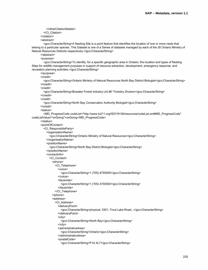
NAP – Metadata, version 1.1
235
</otherCitationDetails> </CI_Citation> </citation> <abstract> <gco:CharacterString>A Nesting Site is a point feature that identifies the location of one or more nests that belong to a particular species. This Dataset is one of a Series of datasets managed by each of the 26 Ontario Ministry of Natural Resources Districts respectively.</gco:CharacterString> </abstract> <purpose> <gco:CharacterString>To identify, for a specific geographic area in Ontario, the location and types of Nesting Sites for wildlife management purposes in support of resource extraction, development, emergency response, and recreation planning activities.</gco:CharacterString> </purpose> <credit> <gco:CharacterString>Ontario Ministry of Natural Resources North Bay District Biologist</gco:CharacterString> </credit> <credit> <gco:CharacterString>Bowater Forest Industry Ltd – Forestry Division</gco:CharacterString> </credit> <credit> <gco:CharacterString>North Bay Conservation Authority Biologist</gco:CharacterString> </credit> <status> <MD_ProgressCode codeList="http://www.tc211.org/ISO19139/resources/codeList.xml#MD_ProgressCode" codeListValue="onGoing">onGoing</MD_ProgressCode> </status> <pointOfContact> <CI_ResponsibleParty> <organisationName> <gco:CharacterString>Ontario Ministry of Natural Resources</gco:CharacterString> </organisationName> <positionName> <gco:CharacterString>North Bay District Biologist</gco:CharacterString> </positionName> <contactInfo> <CI_Contact> <phone> <CI_Telephone> <voice> <gco:CharacterString>1 (705) 4755550</gco:CharacterString> </voice> <facsimile> <gco:CharacterString>1 (705) 4755550</gco:CharacterString> </facsimile> </CI_Telephone> </phone> <address> <CI_Address> <deliveryPoint> <gco:CharacterString>physical; 3301; Trout Lake Road; ;</gco:CharacterString> </deliveryPoint> <city> <gco:CharacterString>North Bay</gco:CharacterString> </city> <administrativeArea> <gco:CharacterString>Ontario</gco:CharacterString> </administrativeArea> <postalCode> <gco:CharacterString>P1A 4L7</gco:CharacterString>

NAP – Metadata, version 1.1
236
</postalCode> <country> <gco:CharacterString>Canada</gco:CharacterString> </country> <electronicMailAddress> <gco:CharacterString>[email protected]</gco:CharacterString> </electronicMailAddress> </CI_Address> </address> </CI_Contact> </contactInfo> <role> <CI_RoleCode codeList="http://www.tc211.org/ISO19139/resources/codeList.xml#CI_RoleCode" codeListValue="custodian">custodian</CI_RoleCode> </role> </CI_ResponsibleParty> </pointOfContact> <resourceMaintenance> <MD_MaintenanceInformation> <maintenanceAndUpdateFrequency> <MD_MaintenanceFrequencyCode codeList="http://www.tc211.org/ISO19139/resources/codeList.xml#MD_MaintenanceFrequencyCode" codeListValue="continual">continual</MD_MaintenanceFrequencyCode> </maintenanceAndUpdateFrequency> <dateOfNextUpdate> <gco:Date>200706 </gco:Date> </dateOfNextUpdate> <userDefinedMaintenanceFrequency> <gts:TM_PeriodDuration>P5Y</gts:TM_PeriodDuration> </userDefinedMaintenanceFrequency> <updateScope> <MD_ScopeCode codeList="http://www.tc211.org/ISO19139/resources/codeList.xml#MD_ScopeCode" codeListValue="attribute">attribute</MD_ScopeCode> </updateScope> <updateScopeDescription> <MD_ScopeDescription> <dataset> <gco:CharacterString>Nesting site data is acquired through general field collection activities, reports from the general public and information provided by external partners/agencies.</gco:CharacterString> </dataset> </MD_ScopeDescription> </updateScopeDescription> <maintenanceNote> <gco:CharacterString>Nests unoccupied for 5 years or more leads to Feature instance being “frozen� (not included for analysis or display).</gco:CharacterString> </maintenanceNote> <contact> <CI_ResponsibleParty> <organisationName> <gco:CharacterString>Ontario Ministry of Natural Resources</gco:CharacterString> </organisationName> <positionName> <gco:CharacterString>North Bay District Biologist</gco:CharacterString> </positionName> <contactInfo> <CI_Contact> <phone> <CI_Telephone> <voice>

NAP – Metadata, version 1.1
237
<gco:CharacterString>1 (705) 4755550</gco:CharacterString> </voice> <facsimile> <gco:CharacterString>1 (705) 4755550</gco:CharacterString> </facsimile> </CI_Telephone> </phone> <address> <CI_Address> <deliveryPoint> <gco:CharacterString>physical; 3301; Trout Lake Road; ;</gco:CharacterString> </deliveryPoint> <city> <gco:CharacterString>North Bay</gco:CharacterString> </city> <administrativeArea> <gco:CharacterString>Ontario</gco:CharacterString> </administrativeArea> <postalCode> <gco:CharacterString>P1A 4L7</gco:CharacterString> </postalCode> <country> <gco:CharacterString>Canada</gco:CharacterString> </country> <electronicMailAddress> <gco:CharacterString>[email protected]</gco:CharacterString> </electronicMailAddress> </CI_Address> </address> </CI_Contact> </contactInfo> <role> <CI_RoleCode codeList="http://www.tc211.org/ISO19139/resources/codeList.xml#CI_RoleCode" codeListValue="custodian">custodian</CI_RoleCode> </role> </CI_ResponsibleParty> </contact> </MD_MaintenanceInformation> </resourceMaintenance> <resourceMaintenance> <MD_MaintenanceInformation> <maintenanceAndUpdateFrequency> <MD_MaintenanceFrequencyCode codeList="http://www.tc211.org/ISO19139/resources/codeList.xml#MD_MaintenanceFrequencyCode" codeListValue="continual">continual</MD_MaintenanceFrequencyCode> </maintenanceAndUpdateFrequency> <dateOfNextUpdate> <gco:Date>200706</gco:Date> </dateOfNextUpdate> <userDefinedMaintenanceFrequency> <gts:TM_PeriodDuration>P5Y</gts:TM_PeriodDuration> </userDefinedMaintenanceFrequency> <updateScope> <MD_ScopeCode codeList="http://www.tc211.org/ISO19139/resources/codeList.xml#MD_ScopeCode" codeListValue="feature">feature</MD_ScopeCode> </updateScope> <updateScopeDescription> <MD_ScopeDescription> <dataset>
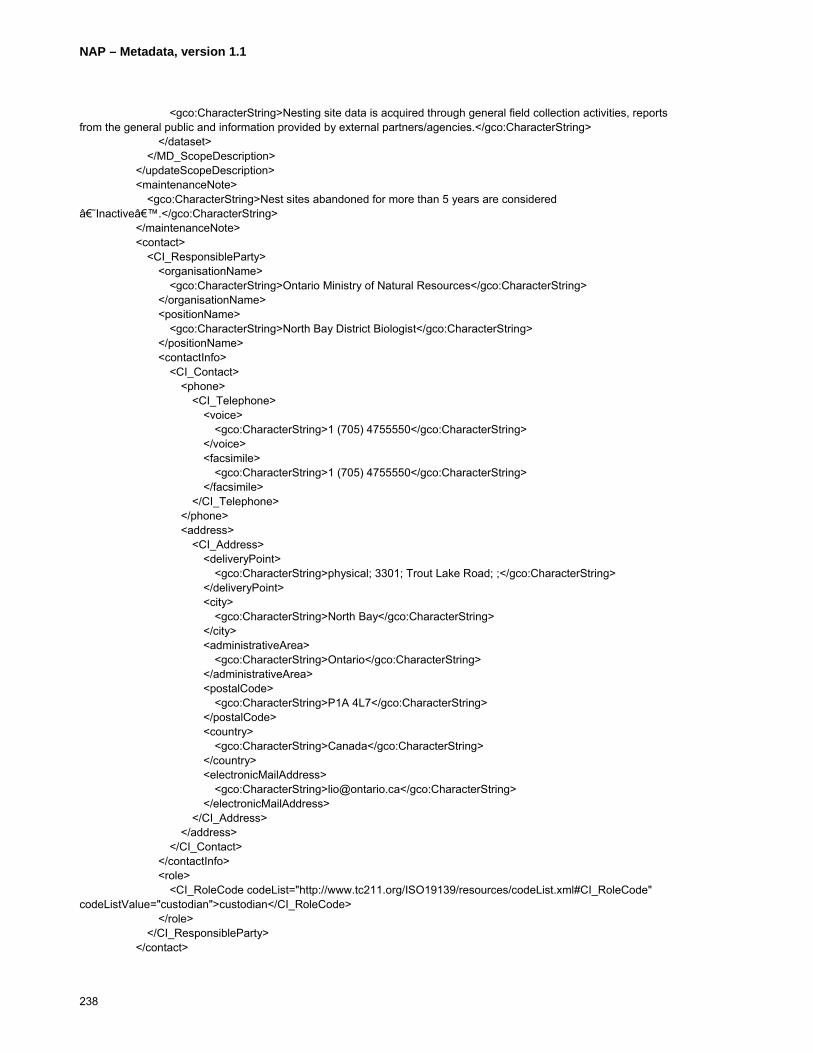
NAP – Metadata, version 1.1
238
<gco:CharacterString>Nesting site data is acquired through general field collection activities, reports from the general public and information provided by external partners/agencies.</gco:CharacterString> </dataset> </MD_ScopeDescription> </updateScopeDescription> <maintenanceNote> <gco:CharacterString>Nest sites abandoned for more than 5 years are considered ‘Inactive’.</gco:CharacterString> </maintenanceNote> <contact> <CI_ResponsibleParty> <organisationName> <gco:CharacterString>Ontario Ministry of Natural Resources</gco:CharacterString> </organisationName> <positionName> <gco:CharacterString>North Bay District Biologist</gco:CharacterString> </positionName> <contactInfo> <CI_Contact> <phone> <CI_Telephone> <voice> <gco:CharacterString>1 (705) 4755550</gco:CharacterString> </voice> <facsimile> <gco:CharacterString>1 (705) 4755550</gco:CharacterString> </facsimile> </CI_Telephone> </phone> <address> <CI_Address> <deliveryPoint> <gco:CharacterString>physical; 3301; Trout Lake Road; ;</gco:CharacterString> </deliveryPoint> <city> <gco:CharacterString>North Bay</gco:CharacterString> </city> <administrativeArea> <gco:CharacterString>Ontario</gco:CharacterString> </administrativeArea> <postalCode> <gco:CharacterString>P1A 4L7</gco:CharacterString> </postalCode> <country> <gco:CharacterString>Canada</gco:CharacterString> </country> <electronicMailAddress> <gco:CharacterString>[email protected]</gco:CharacterString> </electronicMailAddress> </CI_Address> </address> </CI_Contact> </contactInfo> <role> <CI_RoleCode codeList="http://www.tc211.org/ISO19139/resources/codeList.xml#CI_RoleCode" codeListValue="custodian">custodian</CI_RoleCode> </role> </CI_ResponsibleParty> </contact>

NAP – Metadata, version 1.1
239
</MD_MaintenanceInformation> </resourceMaintenance> <graphicOverview> <MD_BrowseGraphic> <fileName> <gco:CharacterString>http://publicdocs.mnr.gov.on.ca/View.asp?Document_ID=9632&Attachment_ID=18204</gco:CharacterString> </fileName> <fileDescription> <gco:CharacterString>Display created in ArcIMS using OMNR Base Data classes (eg roads, water features, utility corridors, treed areas, etc) as context for this point data set.</gco:CharacterString> </fileDescription> <fileType> <gco:CharacterString>jpg</gco:CharacterString> </fileType> </MD_BrowseGraphic> </graphicOverview> <descriptiveKeywords> <MD_Keywords> <keyword> <gco:CharacterString>BIRDS</gco:CharacterString> </keyword> <keyword> <gco:CharacterString>COLONIES</gco:CharacterString> </keyword> <keyword> <gco:CharacterString>NESTING</gco:CharacterString> </keyword> <keyword> <gco:CharacterString>NESTS</gco:CharacterString> </keyword> <type> <MD_KeywordTypeCode codeList="http://www.tc211.org/ISO19139/resources/codeList.xml#MD_KeywordTypeCode" codeListValue="theme">theme</MD_KeywordTypeCode> </type> <thesaurusName> <CI_Citation> <title> <gco:CharacterString>Ontario Ministry of Natural Resources (OMNR) Thesaurus</gco:CharacterString> </title> <date> <CI_Date> <date> <gco:Date>19720622</gco:Date> </date> <dateType> <CI_DateTypeCode codeList="http://www.tc211.org/ISO19139/resources/codeList.xml#CI_DateTypeCode" codeListValue="creation">creation</CI_DateTypeCode> </dateType> </CI_Date> </date> <date> <CI_Date> <date> <gco:Date>20060716</gco:Date> </date>

NAP – Metadata, version 1.1
240
<dateType> <CI_DateTypeCode codeList="http://www.tc211.org/ISO19139/resources/codeList.xml#CI_DateTypeCode" codeListValue="revision">revision</CI_DateTypeCode> </dateType> </CI_Date> </date> <edition> <gco:CharacterString>Originally created to catalogue documents stored in the OMNR library and since modified</gco:CharacterString> </edition> <citedResponsibleParty> <CI_ResponsibleParty> <organisationName> <gco:CharacterString>Ministry of Natural Resources</gco:CharacterString> </organisationName> <role> <CI_RoleCode codeList="http://www.tc211.org/ISO19139/resources/codeList.xml#CI_RoleCode" codeListValue="pointOfContact">pointOfContact</CI_RoleCode> </role> </CI_ResponsibleParty> </citedResponsibleParty> </CI_Citation> </thesaurusName> </MD_Keywords> </descriptiveKeywords> <descriptiveKeywords> <MD_Keywords> <keyword> <gco:CharacterString>FOREST MANAGEMENT</gco:CharacterString> </keyword> <keyword> <gco:CharacterString>FORESTRY</gco:CharacterString> </keyword> <keyword> <gco:CharacterString>LAND USE PLANNING</gco:CharacterString> </keyword> <keyword> <gco:CharacterString>MUNICIPAL PLANNING</gco:CharacterString> </keyword> <keyword> <gco:CharacterString>WILDLIFE</gco:CharacterString> </keyword> <type> <MD_KeywordTypeCode codeList="http://www.tc211.org/ISO19139/resources/codeList.xml#MD_KeywordTypeCode" codeListValue="discipline">discipline</MD_KeywordTypeCode> </type> <thesaurusName> <CI_Citation> <title> <gco:CharacterString>Ontario Ministry of Natural Resources (OMNR) Thesaurus</gco:CharacterString> </title> <date> <CI_Date> <date> <gco:Date>19720622</gco:Date> </date> <dateType>
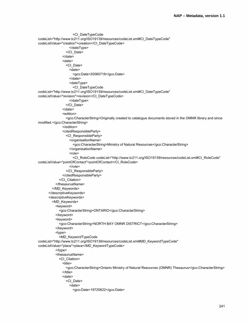
NAP – Metadata, version 1.1
241
<CI_DateTypeCode codeList="http://www.tc211.org/ISO19139/resources/codeList.xml#CI_DateTypeCode" codeListValue="creation">creation</CI_DateTypeCode> </dateType> </CI_Date> </date> <date> <CI_Date> <date> <gco:Date>20060716</gco:Date> </date> <dateType> <CI_DateTypeCode codeList="http://www.tc211.org/ISO19139/resources/codeList.xml#CI_DateTypeCode" codeListValue="revision">revision</CI_DateTypeCode> </dateType> </CI_Date> </date> <edition> <gco:CharacterString>Originally created to catalogue documents stored in the OMNR library and since modified.</gco:CharacterString> </edition> <citedResponsibleParty> <CI_ResponsibleParty> <organisationName> <gco:CharacterString>Ministry of Natural Resources</gco:CharacterString> </organisationName> <role> <CI_RoleCode codeList="http://www.tc211.org/ISO19139/resources/codeList.xml#CI_RoleCode" codeListValue="pointOfContact">pointOfContact</CI_RoleCode> </role> </CI_ResponsibleParty> </citedResponsibleParty> </CI_Citation> </thesaurusName> </MD_Keywords> </descriptiveKeywords> <descriptiveKeywords> <MD_Keywords> <keyword> <gco:CharacterString>ONTARIO</gco:CharacterString> </keyword> <keyword> <gco:CharacterString>NORTH BAY OMNR DISTRICT</gco:CharacterString> </keyword> <type> <MD_KeywordTypeCode codeList="http://www.tc211.org/ISO19139/resources/codeList.xml#MD_KeywordTypeCode" codeListValue="place">place</MD_KeywordTypeCode> </type> <thesaurusName> <CI_Citation> <title> <gco:CharacterString>Ontario Ministry of Natural Resources (OMNR) Thesaurus</gco:CharacterString> </title> <date> <CI_Date> <date> <gco:Date>19720622</gco:Date>
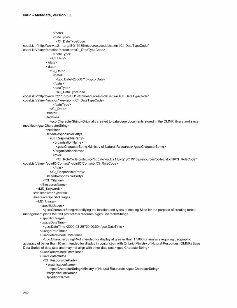
NAP – Metadata, version 1.1
242
</date> <dateType> <CI_DateTypeCode codeList="http://www.tc211.org/ISO19139/resources/codeList.xml#CI_DateTypeCode" codeListValue="creation">creation</CI_DateTypeCode> </dateType> </CI_Date> </date> <date> <CI_Date> <date> <gco:Date>20060716</gco:Date> </date> <dateType> <CI_DateTypeCode codeList="http://www.tc211.org/ISO19139/resources/codeList.xml#CI_DateTypeCode" codeListValue="revision">revision</CI_DateTypeCode> </dateType> </CI_Date> </date> <edition> <gco:CharacterString>Originally created to catalogue documents stored in the OMNR library and since modified</gco:CharacterString> </edition> <citedResponsibleParty> <CI_ResponsibleParty> <organisationName> <gco:CharacterString>Ministry of Natural Resources</gco:CharacterString> </organisationName> <role> <CI_RoleCode codeList="http://www.tc211.org/ISO19139/resources/codeList.xml#CI_RoleCode" codeListValue="pointOfContact">pointOfContact</CI_RoleCode> </role> </CI_ResponsibleParty> </citedResponsibleParty> </CI_Citation> </thesaurusName> </MD_Keywords> </descriptiveKeywords> <resourceSpecificUsage> <MD_Usage> <specificUsage> <gco:CharacterString>Identifying the location and types of nesting Sites for the purpose of creating forest management plans that will protect this resource.</gco:CharacterString> </specificUsage> <usageDateTime> <gco:DateTime>2000-03-25T00:00:00</gco:DateTime> </usageDateTime> <userDeterminedLimitations> <gco:CharacterString>Not intended for display at greater than 1:5000 or analysis requiring geographic accuracy of better than 10 m. Intended for display in conjunction with Ontario Ministry of Natural Resources (OMNR) Base Data Series of data sets and may not align with other data sets.</gco:CharacterString> </userDeterminedLimitations> <userContactInfo> <CI_ResponsibleParty> <organisationName> <gco:CharacterString>Ministry of Natural Resources</gco:CharacterString> </organisationName> <positionName>

NAP – Metadata, version 1.1
243
<gco:CharacterString>Land Information Ontario Support</gco:CharacterString> </positionName> <contactInfo> <CI_Contact> <phone> <CI_Telephone> <voice> <gco:CharacterString>1(705) 7551878</gco:CharacterString> </voice> <facsimile> <gco:CharacterString>1 (705) 7551677</gco:CharacterString> </facsimile> </CI_Telephone> </phone> <address> <CI_Address> <deliveryPoint> <gco:CharacterString>physical; 300; Water Street; ;</gco:CharacterString> </deliveryPoint> <city> <gco:CharacterString>Peterborough</gco:CharacterString> </city> <administrativeArea> <gco:CharacterString>Ontario</gco:CharacterString> </administrativeArea> <postalCode> <gco:CharacterString>K7J 8M5</gco:CharacterString> </postalCode> <country> <gco:CharacterString>Canada</gco:CharacterString> </country> <electronicMailAddress> <gco:CharacterString>[email protected]</gco:CharacterString> </electronicMailAddress> </CI_Address> </address> </CI_Contact> </contactInfo> <role> <CI_RoleCode codeList="http://www.tc211.org/ISO19139/resources/codeList.xml#CI_RoleCode" codeListValue="pointOfContact">pointOfContact</CI_RoleCode> </role> </CI_ResponsibleParty> </userContactInfo> </MD_Usage> </resourceSpecificUsage> <resourceSpecificUsage> <MD_Usage> <specificUsage> <gco:CharacterString>Identifying the location and types of nesting Sites for the purpose of increasing wildlife habitat and biodiversity through various initiatives.</gco:CharacterString> </specificUsage> <usageDateTime> <gco:DateTime>2004-05-26T00:00:00</gco:DateTime> </usageDateTime> <userDeterminedLimitations> <gco:CharacterString>Not intended for display at greater than 1:5000 or analysis requiring geographic accuracy of better than 10 m. Intended for display in conjunction with Ontario Ministry of Natural Resources (OMNR) Base Data Series of data sets and may not align with other data sets.</gco:CharacterString>

NAP – Metadata, version 1.1
244
</userDeterminedLimitations> <userContactInfo> <CI_ResponsibleParty> <organisationName> <gco:CharacterString>Ministry of Natural Resources</gco:CharacterString> </organisationName> <positionName> <gco:CharacterString>Land Information Ontario Support</gco:CharacterString> </positionName> <contactInfo> <CI_Contact> <phone> <CI_Telephone> <voice> <gco:CharacterString>1(705) 7551878</gco:CharacterString> </voice> <facsimile> <gco:CharacterString>1 (705) 7551677</gco:CharacterString> </facsimile> </CI_Telephone> </phone> <address> <CI_Address> <deliveryPoint> <gco:CharacterString>physical; 300; Water Street; ;</gco:CharacterString> </deliveryPoint> <city> <gco:CharacterString>Peterborough</gco:CharacterString> </city> <administrativeArea> <gco:CharacterString>Ontario</gco:CharacterString> </administrativeArea> <postalCode> <gco:CharacterString>K7J 8M5</gco:CharacterString> </postalCode> <country> <gco:CharacterString>Canada</gco:CharacterString> </country> <electronicMailAddress> <gco:CharacterString>[email protected]</gco:CharacterString> </electronicMailAddress> </CI_Address> </address> </CI_Contact> </contactInfo> <role> <CI_RoleCode codeList="http://www.tc211.org/ISO19139/resources/codeList.xml#CI_RoleCode" codeListValue="pointOfContact">pointOfContact</CI_RoleCode> </role> </CI_ResponsibleParty> </userContactInfo> </MD_Usage> </resourceSpecificUsage> <resourceConstraints> <MD_Constraints> <useLimitation> <gco:CharacterString>This information holding is not to be used for Legal Purposes.</gco:CharacterString> </useLimitation> <useLimitation>

NAP – Metadata, version 1.1
245
<gco:CharacterString>Statutory: This Information holding is to be used only for the purposes for which it was collected. Use must be in accordance with the terms of the licence issued by the Ontario Ministry of Natural Resources.</gco:CharacterString> </useLimitation> <useLimitation> <gco:CharacterString>Sensitivity: Although generally available to the public, some of the information in this information holding may be considered sensitive and, as such, access to the holding may, in whole or in part, be restricted to authorized individuals and/or organizations in accordance with the Ontario Rare and Endangered Species Act 2003. For more information, see Selected Wildlife and Habitat Features>Inventory Manual, W. B. Ranta, Kenora District, Section 2.2d. A list of authorized users is available from the Ontario Ministry of Natural Resources (OMNR) Information Access unit.</gco:CharacterString> </useLimitation> <useLimitation> <gco:CharacterString>Privacy: There are no known privacy concerns in this information holding.</gco:CharacterString> </useLimitation> </MD_Constraints> </resourceConstraints> <resourceConstraints> <MD_LegalConstraints> <accessConstraints> <MD_RestrictionCode codeList="http://www.tc211.org/ISO19139/resources/codeList.xml#MD_RestrictionCode" codeListValue="otherRestrictions">otherRestrictions</MD_RestrictionCode> </accessConstraints> <useConstraints> <MD_RestrictionCode codeList="http://www.tc211.org/ISO19139/resources/codeList.xml#MD_RestrictionCode" codeListValue="license">license</MD_RestrictionCode> </useConstraints> </MD_LegalConstraints> </resourceConstraints> <resourceConstraints> <MD_SecurityConstraints> <classification> <MD_ClassificationCode codeList="http://www.tc211.org/ISO19139/resources/codeList.xml#MD_ClassificationCode" codeListValue="unclassified">unclassified</MD_ClassificationCode> </classification> </MD_SecurityConstraints> </resourceConstraints> <aggregationInfo> <MD_AggregateInformation> <aggregateDataSetName> <CI_Citation> <title> <gco:CharacterString>Nesting Site Province</gco:CharacterString> </title> <date> <CI_Date> <date> <gco:Date>20070719</gco:Date> </date> <dateType> <CI_DateTypeCode codeList="http://www.tc211.org/ISO19139/resources/codeList.xml#CI_DateTypeCode" codeListValue="creation">creation</CI_DateTypeCode> </dateType> </CI_Date>
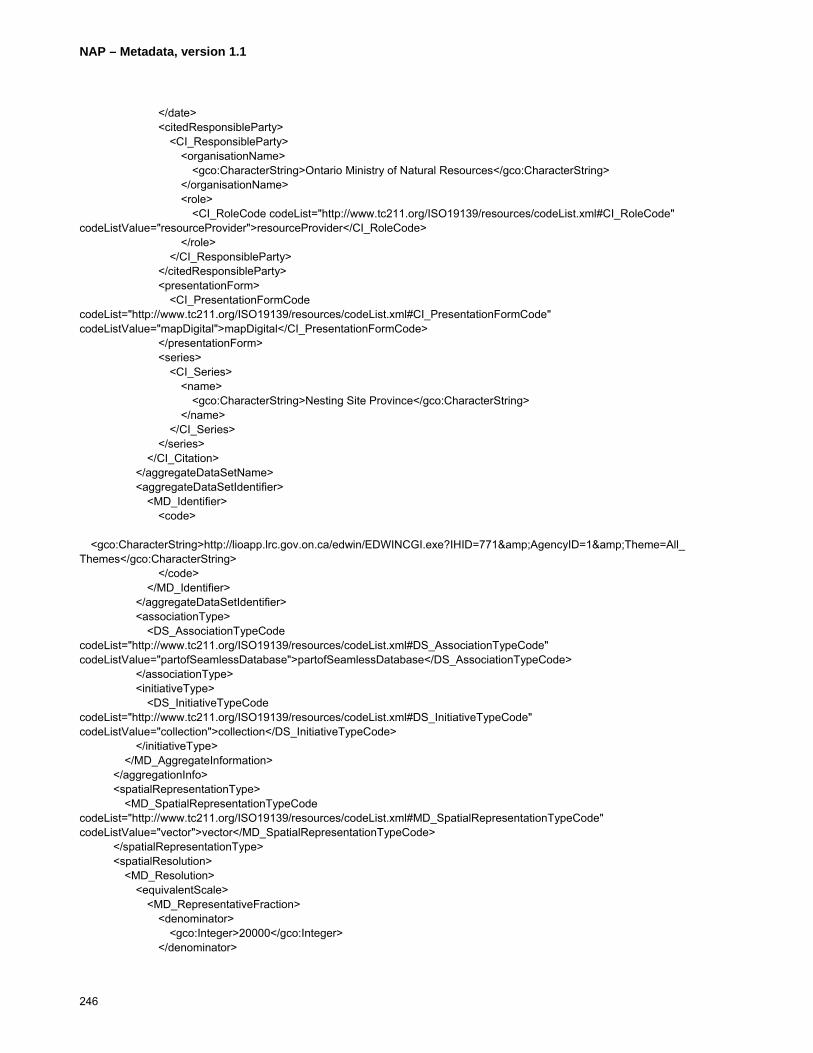
NAP – Metadata, version 1.1
246
</date> <citedResponsibleParty> <CI_ResponsibleParty> <organisationName> <gco:CharacterString>Ontario Ministry of Natural Resources</gco:CharacterString> </organisationName> <role> <CI_RoleCode codeList="http://www.tc211.org/ISO19139/resources/codeList.xml#CI_RoleCode" codeListValue="resourceProvider">resourceProvider</CI_RoleCode> </role> </CI_ResponsibleParty> </citedResponsibleParty> <presentationForm> <CI_PresentationFormCode codeList="http://www.tc211.org/ISO19139/resources/codeList.xml#CI_PresentationFormCode" codeListValue="mapDigital">mapDigital</CI_PresentationFormCode> </presentationForm> <series> <CI_Series> <name> <gco:CharacterString>Nesting Site Province</gco:CharacterString> </name> </CI_Series> </series> </CI_Citation> </aggregateDataSetName> <aggregateDataSetIdentifier> <MD_Identifier> <code> <gco:CharacterString>http://lioapp.lrc.gov.on.ca/edwin/EDWINCGI.exe?IHID=771&AgencyID=1&Theme=All_Themes</gco:CharacterString> </code> </MD_Identifier> </aggregateDataSetIdentifier> <associationType> <DS_AssociationTypeCode codeList="http://www.tc211.org/ISO19139/resources/codeList.xml#DS_AssociationTypeCode" codeListValue="partofSeamlessDatabase">partofSeamlessDatabase</DS_AssociationTypeCode> </associationType> <initiativeType> <DS_InitiativeTypeCode codeList="http://www.tc211.org/ISO19139/resources/codeList.xml#DS_InitiativeTypeCode" codeListValue="collection">collection</DS_InitiativeTypeCode> </initiativeType> </MD_AggregateInformation> </aggregationInfo> <spatialRepresentationType> <MD_SpatialRepresentationTypeCode codeList="http://www.tc211.org/ISO19139/resources/codeList.xml#MD_SpatialRepresentationTypeCode" codeListValue="vector">vector</MD_SpatialRepresentationTypeCode> </spatialRepresentationType> <spatialResolution> <MD_Resolution> <equivalentScale> <MD_RepresentativeFraction> <denominator> <gco:Integer>20000</gco:Integer> </denominator>
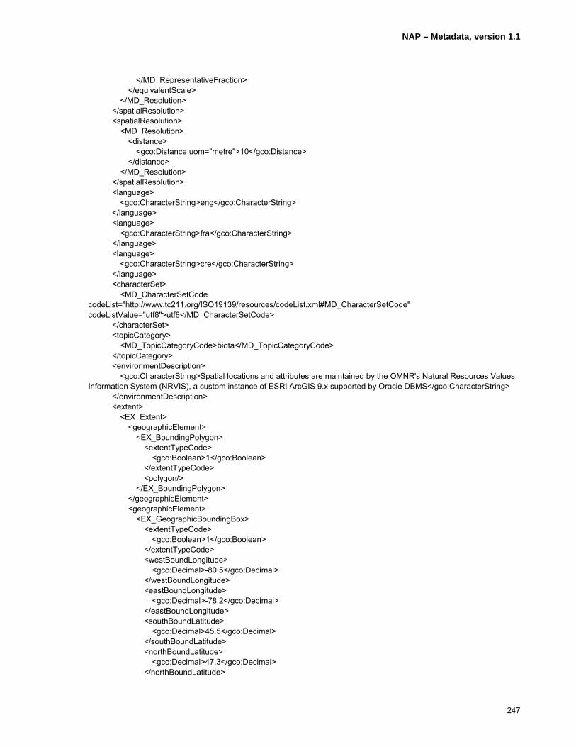
NAP – Metadata, version 1.1
247
</MD_RepresentativeFraction> </equivalentScale> </MD_Resolution> </spatialResolution> <spatialResolution> <MD_Resolution> <distance> <gco:Distance uom="metre">10</gco:Distance> </distance> </MD_Resolution> </spatialResolution> <language> <gco:CharacterString>eng</gco:CharacterString> </language> <language> <gco:CharacterString>fra</gco:CharacterString> </language> <language> <gco:CharacterString>cre</gco:CharacterString> </language> <characterSet> <MD_CharacterSetCode codeList="http://www.tc211.org/ISO19139/resources/codeList.xml#MD_CharacterSetCode" codeListValue="utf8">utf8</MD_CharacterSetCode> </characterSet> <topicCategory> <MD_TopicCategoryCode>biota</MD_TopicCategoryCode> </topicCategory> <environmentDescription> <gco:CharacterString>Spatial locations and attributes are maintained by the OMNR's Natural Resources Values Information System (NRVIS), a custom instance of ESRI ArcGIS 9.x supported by Oracle DBMS</gco:CharacterString> </environmentDescription> <extent> <EX_Extent> <geographicElement> <EX_BoundingPolygon> <extentTypeCode> <gco:Boolean>1</gco:Boolean> </extentTypeCode> <polygon/> </EX_BoundingPolygon> </geographicElement> <geographicElement> <EX_GeographicBoundingBox> <extentTypeCode> <gco:Boolean>1</gco:Boolean> </extentTypeCode> <westBoundLongitude> <gco:Decimal>-80.5</gco:Decimal> </westBoundLongitude> <eastBoundLongitude> <gco:Decimal>-78.2</gco:Decimal> </eastBoundLongitude> <southBoundLatitude> <gco:Decimal>45.5</gco:Decimal> </southBoundLatitude> <northBoundLatitude> <gco:Decimal>47.3</gco:Decimal> </northBoundLatitude>

NAP – Metadata, version 1.1
248
</EX_GeographicBoundingBox> </geographicElement> </EX_Extent> </extent> </MD_DataIdentification> </identificationInfo> <identificationInfo> <srv:SV_ServiceIdentification> <citation> <CI_Citation> <title> <gco:CharacterString>Habitat Web Map Service (WMS)</gco:CharacterString> </title> <date> <CI_Date> <date> <gco:Date>20050101</gco:Date> </date> <dateType> <CI_DateTypeCode codeList="http://www.tc211.org/ISO19139/resources/codeList.xml#CI_DateTypeCode" codeListValue="creation">creation</CI_DateTypeCode> </dateType> </CI_Date> </date> <citedResponsibleParty> <CI_ResponsibleParty> <organisationName> <gco:CharacterString>Ontario Ministry of Natural Resources – Land Information Ontario</gco:CharacterString> </organisationName> <contactInfo> <CI_Contact> <phone> <CI_Telephone> <voice> <gco:CharacterString>1(705) 7551878</gco:CharacterString> </voice> <facsimile> <gco:CharacterString>1 (705) 7551677</gco:CharacterString> </facsimile> </CI_Telephone> </phone> <address> <CI_Address> <deliveryPoint> <gco:CharacterString>physical; 300; Water Street;;</gco:CharacterString> </deliveryPoint> <city> <gco:CharacterString>Peterborough</gco:CharacterString> </city> <administrativeArea> <gco:CharacterString>Ontario</gco:CharacterString> </administrativeArea> <postalCode> <gco:CharacterString>K7J 8M5</gco:CharacterString> </postalCode> <country> <gco:CharacterString>Canada</gco:CharacterString>

NAP – Metadata, version 1.1
249
</country> <electronicMailAddress> <gco:CharacterString>[email protected]</gco:CharacterString> </electronicMailAddress> </CI_Address> </address> <onlineResource> <CI_OnlineResource> <linkage> <URL>http://www.lio.gov.on.ca/en/ws_WMS.htm</URL> </linkage> </CI_OnlineResource> </onlineResource> </CI_Contact> </contactInfo> <role> <CI_RoleCode codeList="http://www.tc211.org/ISO19139/resources/codeList.xml#CI_RoleCode" codeListValue="resourceProvider">resourceProvider</CI_RoleCode> </role> </CI_ResponsibleParty> </citedResponsibleParty> </CI_Citation> </citation> <abstract> <gco:CharacterString>This Service comprises a subset of Geospatial data classes stored in the Ontario Land Information Warehouse related to wildlife habitat for several species in Ontario such as feeding areas, breeding areas, calving areas and nesting sites. It is available for use as an OGC-compliant Web Map Service (WMS).</gco:CharacterString> </abstract> <status> <MD_ProgressCode codeList="http://www.tc211.org/ISO19139/resources/codeList.xml#MD_ProgressCode" codeListValue="onGoing">onGoing</MD_ProgressCode> </status> <srv:serviceType> <gco:LocalName codeSpace="http://www.tc211.org/ISO19119/serviceTypes">WMS</gco:LocalName> </srv:serviceType> <srv:couplingType> <srv:SV_CouplingType codeListValue="tight" codeList="http://www.tc211.org/ISO19119/resources/codeList.xml#SV_CouplingTypeListCode"/> </srv:couplingType> <srv:containsOperations> <srv:SV_OperationMetadata> <srv:operationName> <gco:CharacterString>webServices</gco:CharacterString> </srv:operationName> <srv:DCP> <srv:DCPList codeListValue="WebServices" codeList="http://www.tc211.org/ISO19119/resources/codeList.xml#SV_DCPListCode">WebServices</srv:DCPList> </srv:DCP> <srv:parameters> <srv:SV_Parameter> <srv:name> <gco:aName> <gco:CharacterString>paramName</gco:CharacterString> </gco:aName> <!-- forced by schema to put gco:attributeType --> <!-- may be it is a duplication of srv:valueType ? --> <gco:attributeType> <gco:TypeName>

NAP – Metadata, version 1.1
250
<gco:aName> <gco:CharacterString>CharacterString?</gco:CharacterString> </gco:aName> </gco:TypeName> </gco:attributeType> </srv:name> <srv:optionality> <gco:CharacterString>Mandatory</gco:CharacterString> </srv:optionality> <srv:repeatability> <gco:Boolean>false</gco:Boolean> </srv:repeatability> <srv:valueType> <gco:TypeName> <gco:aName> <gco:CharacterString>CharacterString</gco:CharacterString> </gco:aName> </gco:TypeName> </srv:valueType> </srv:SV_Parameter> </srv:parameters> <srv:connectPoint> <CI_OnlineResource> <linkage> <URL>http://lioapp.lrc.gov.on.ca/LioOgcWms21/lioogcwmsserver/wms_habitat?version=1.1.1&request=GetCapabilities&service=WMS</URL> </linkage> <protocol> <gco:CharacterString>http</gco:CharacterString> </protocol> </CI_OnlineResource> </srv:connectPoint> </srv:SV_OperationMetadata> </srv:containsOperations> </srv:SV_ServiceIdentification> </identificationInfo> <contentInfo> <MD_FeatureCatalogueDescription> <complianceCode> <gco:Boolean>false</gco:Boolean> </complianceCode> <language> <gco:CharacterString>eng; CAN; utf8</gco:CharacterString> </language> <includedWithDataset> <gco:Boolean>false</gco:Boolean> </includedWithDataset> <featureTypes> <gco:LocalName>1015 Bald Eagle Nesting Site</gco:LocalName> </featureTypes> <featureTypes> <gco:LocalName>1042 Common Barn Owl Nesting Site</gco:LocalName> </featureTypes> <featureTypes> <gco:LocalName>1097 Golden Eagle Nesting Site</gco:LocalName> </featureTypes> <featureTypes> <gco:LocalName>1185 Peregrine Falcon Nesting Site</gco:LocalName>

NAP – Metadata, version 1.1
251
</featureTypes> <featureTypes> <gco:LocalName>1314 Cormorant Nesting Site/Colony</gco:LocalName> </featureTypes> <featureTypes> <gco:LocalName>1211 Red-Shouldered Hawk Nesting Site</gco:LocalName> </featureTypes> <featureTypes> <gco:LocalName>1180 Osprey Nesting Site</gco:LocalName> </featureTypes> <featureTypes> <gco:LocalName>1432 Common Tern Nesting Site/Colony</gco:LocalName> </featureTypes> <featureTypes> <gco:LocalName>1346 Unidentified Eagle/Osprey Nesting Site</gco:LocalName> </featureTypes> <featureTypes> <gco:LocalName>1100 Great Blue Heron Nesting Site/Colony</gco:LocalName> </featureTypes> <featureCatalogueCitation> <CI_Citation> <title> <gco:CharacterString>Standard NRVIS Interchange Format (SNIF) Report – ‘Nesting Site’</gco:CharacterString> </title> <alternateTitle> <gco:CharacterString>SNIF Report – ‘Nesting Site’</gco:CharacterString> </alternateTitle> <date> <CI_Date> <date> <gco:Date>20060620</gco:Date> </date> <dateType> <CI_DateTypeCode codeList="http://www.tc211.org/ISO19139/resources/codeList.xml#CI_DateTypeCode" codeListValue="revision">revision</CI_DateTypeCode> </dateType> </CI_Date> </date> <edition> <gco:CharacterString>SNIF Version 2.0</gco:CharacterString> </edition> <editionDate> <gco:Date>20030522</gco:Date> </editionDate> <citedResponsibleParty> <CI_ResponsibleParty> <organisationName> <gco:CharacterString>Ministry of Natural Resources</gco:CharacterString> </organisationName> <positionName> <gco:CharacterString>Land Information Ontario Support</gco:CharacterString> </positionName> <contactInfo> <CI_Contact> <phone> <CI_Telephone> <voice>
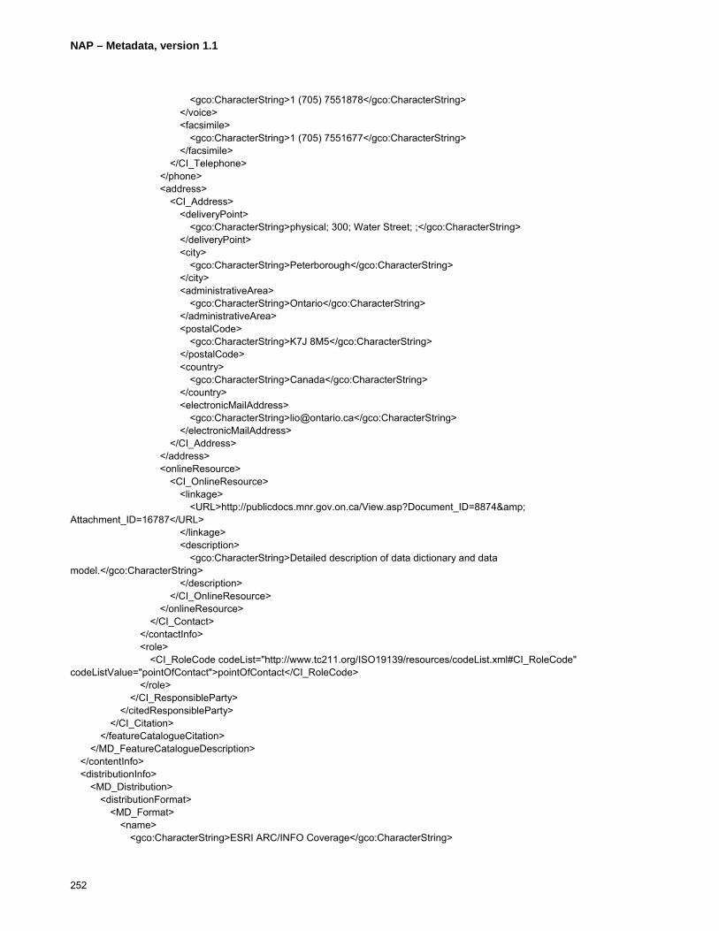
NAP – Metadata, version 1.1
252
<gco:CharacterString>1 (705) 7551878</gco:CharacterString> </voice> <facsimile> <gco:CharacterString>1 (705) 7551677</gco:CharacterString> </facsimile> </CI_Telephone> </phone> <address> <CI_Address> <deliveryPoint> <gco:CharacterString>physical; 300; Water Street; ;</gco:CharacterString> </deliveryPoint> <city> <gco:CharacterString>Peterborough</gco:CharacterString> </city> <administrativeArea> <gco:CharacterString>Ontario</gco:CharacterString> </administrativeArea> <postalCode> <gco:CharacterString>K7J 8M5</gco:CharacterString> </postalCode> <country> <gco:CharacterString>Canada</gco:CharacterString> </country> <electronicMailAddress> <gco:CharacterString>[email protected]</gco:CharacterString> </electronicMailAddress> </CI_Address> </address> <onlineResource> <CI_OnlineResource> <linkage> <URL>http://publicdocs.mnr.gov.on.ca/View.asp?Document_ID=8874& Attachment_ID=16787</URL> </linkage> <description> <gco:CharacterString>Detailed description of data dictionary and data model.</gco:CharacterString> </description> </CI_OnlineResource> </onlineResource> </CI_Contact> </contactInfo> <role> <CI_RoleCode codeList="http://www.tc211.org/ISO19139/resources/codeList.xml#CI_RoleCode" codeListValue="pointOfContact">pointOfContact</CI_RoleCode> </role> </CI_ResponsibleParty> </citedResponsibleParty> </CI_Citation> </featureCatalogueCitation> </MD_FeatureCatalogueDescription> </contentInfo> <distributionInfo> <MD_Distribution> <distributionFormat> <MD_Format> <name> <gco:CharacterString>ESRI ARC/INFO Coverage</gco:CharacterString>

NAP – Metadata, version 1.1
253
</name> <version> <gco:CharacterString>ArcGIS 8.3</gco:CharacterString> </version> </MD_Format> </distributionFormat> <distributionFormat> <MD_Format> <name> <gco:CharacterString>ESRI Shapefile</gco:CharacterString> </name> <version> <gco:CharacterString>ArcGIS 8.3</gco:CharacterString> </version> </MD_Format> </distributionFormat> <distributionFormat> <MD_Format> <name> <gco:CharacterString>ESRI ARC/INFO Export (.e00)</gco:CharacterString> </name> <version> <gco:CharacterString>ArcGIS 8.3</gco:CharacterString> </version> </MD_Format> </distributionFormat> <distributionFormat> <MD_Format> <name> <gco:CharacterString>MNR NRVIS-Lite</gco:CharacterString> </name> <version> <gco:CharacterString>2.1</gco:CharacterString> </version> </MD_Format> </distributionFormat> <distributor> <MD_Distributor> <distributorContact> <CI_ResponsibleParty> <contactInfo> <CI_Contact> <phone> <CI_Telephone> <voice> <gco:CharacterString>1 (705) 7551878</gco:CharacterString> </voice> <facsimile> <gco:CharacterString>1 (705) 7551677</gco:CharacterString> </facsimile> </CI_Telephone> </phone> <address> <CI_Address> <deliveryPoint> <gco:CharacterString>physical; 300; Water Street; ;</gco:CharacterString> </deliveryPoint> <city> <gco:CharacterString>Peterborough</gco:CharacterString>

NAP – Metadata, version 1.1
254
</city> <administrativeArea> <gco:CharacterString>Ontario</gco:CharacterString> </administrativeArea> <postalCode> <gco:CharacterString>K7J 8M5</gco:CharacterString> </postalCode> <country> <gco:CharacterString>Canada</gco:CharacterString> </country> <electronicMailAddress> <gco:CharacterString>[email protected]</gco:CharacterString> </electronicMailAddress> </CI_Address> </address> </CI_Contact> </contactInfo> <role> <CI_RoleCode codeList="http://www.tc211.org/ISO19139/resources/codeList.xml#CI_RoleCode" codeListValue="distributor">distributor</CI_RoleCode> </role> </CI_ResponsibleParty> </distributorContact> </MD_Distributor> </distributor> <transferOptions> <MD_DigitalTransferOptions> <offLine> <MD_Medium> <name> <MD_MediumNameCode codeList="http://www.tc211.org/ISO19139/resources/codeList.xml#MD_MediumNameCode" codeListValue="cdRom">cdRom</MD_MediumNameCode> </name> </MD_Medium> </offLine> </MD_DigitalTransferOptions> </transferOptions> <transferOptions> <MD_DigitalTransferOptions> <offLine> <MD_Medium> <name> <MD_MediumNameCode codeList="http://www.tc211.org/ISO19139/resources/codeList.xml#MD_MediumNameCode" codeListValue="dvdRom">dvdRom</MD_MediumNameCode> </name> </MD_Medium> </offLine> </MD_DigitalTransferOptions> </transferOptions> </MD_Distribution> </distributionInfo> <dataQualityInfo> <DQ_DataQuality> <scope> <DQ_Scope> <level>
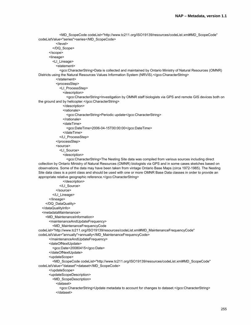
NAP – Metadata, version 1.1
255
<MD_ScopeCode codeList="http://www.tc211.org/ISO19139/resources/codeList.xml#MD_ScopeCode" codeListValue="series">series</MD_ScopeCode> </level> </DQ_Scope> </scope> <lineage> <LI_Lineage> <statement> <gco:CharacterString>Data is collected and maintained by Ontario Ministry of Natural Resources (OMNR) Districts using the Natural Resources Values Information System (NRVIS).</gco:CharacterString> </statement> <processStep> <LI_ProcessStep> <description> <gco:CharacterString>Investigation by OMNR staff biologists via GPS and remote GIS devices both on the ground and by helicopter.</gco:CharacterString> </description> <rationale> <gco:CharacterString>Periodic update</gco:CharacterString> </rationale> <dateTime> <gco:DateTime>2006-04-15T00:00:00</gco:DateTime> </dateTime> </LI_ProcessStep> </processStep> <source> <LI_Source> <description> <gco:CharacterString>The Nesting Site data was compiled from various sources including direct collection by Ontario Ministry of Natural Resources (OMNR) biologists via GPS and in some cases sketches based on observations. Some of the data may have been taken from vintage Ontario Base Maps (circa 1972-1985). The Nesting Site data class is a point class and should be used with one or more OMNR Base Data classes in order to provide an appropriate relative geographic reference.</gco:CharacterString> </description> </LI_Source> </source> </LI_Lineage> </lineage> </DQ_DataQuality> </dataQualityInfo> <metadataMaintenance> <MD_MaintenanceInformation> <maintenanceAndUpdateFrequency> <MD_MaintenanceFrequencyCode codeList="http://www.tc211.org/ISO19139/resources/codeList.xml#MD_MaintenanceFrequencyCode" codeListValue="annually">annually</MD_MaintenanceFrequencyCode> </maintenanceAndUpdateFrequency> <dateOfNextUpdate> <gco:Date>20080415</gco:Date> </dateOfNextUpdate> <updateScope> <MD_ScopeCode codeList="http://www.tc211.org/ISO19139/resources/codeList.xml#MD_ScopeCode" codeListValue="dataset">dataset</MD_ScopeCode> </updateScope> <updateScopeDescription> <MD_ScopeDescription> <dataset> <gco:CharacterString>Update metadata to account for changes to dataset.</gco:CharacterString> </dataset>

NAP – Metadata, version 1.1
256
</MD_ScopeDescription> </updateScopeDescription> <contact> <CI_ResponsibleParty> <organisationName> <gco:CharacterString>Ontario Ministry of Natural Resources</gco:CharacterString> </organisationName> <positionName> <gco:CharacterString>North Bay District Biologist</gco:CharacterString> </positionName> <contactInfo> <CI_Contact> <phone> <CI_Telephone> <voice> <gco:CharacterString>1 (705) 4755550</gco:CharacterString> </voice> <facsimile> <gco:CharacterString>1 (705) 4755550</gco:CharacterString> </facsimile> </CI_Telephone> </phone> <address> <CI_Address> <deliveryPoint> <gco:CharacterString>physical; 3301; Trout Lake Road; ;</gco:CharacterString> </deliveryPoint> <city> <gco:CharacterString>North Bay</gco:CharacterString> </city> <administrativeArea> <gco:CharacterString>Ontario</gco:CharacterString> </administrativeArea> <postalCode> <gco:CharacterString>P1A 4L7</gco:CharacterString> </postalCode> <country> <gco:CharacterString>Canada</gco:CharacterString> </country> <electronicMailAddress> <gco:CharacterString>[email protected]</gco:CharacterString> </electronicMailAddress> </CI_Address> </address> </CI_Contact> </contactInfo> <role> <CI_RoleCode codeList="http://www.tc211.org/ISO19139/resources/codeList.xml#CI_RoleCode" codeListValue="custodian">custodian</CI_RoleCode> </role> </CI_ResponsibleParty> </contact> </MD_MaintenanceInformation> </metadataMaintenance> </MD_Metadata>

NAP – Metadata, version 1.1
257
E.5.4 Feature Level Metadata – OMNR North Bay District - Great Blue Heron Nesting Site/Colony
<?xml version="1.0" encoding="UTF-8"?> <MD_Metadata xmlns="http://www.isotc211.org/2005/gmd" xmlns:gco="http://www.isotc211.org/2005/gco" xmlns:gts="http://www.isotc211.org/2005/gts" xmlns:gss="http://www.isotc211.org/2005/gss" xmlns:gsr="http://www.isotc211.org/2005/gsr" xmlns:xlink="http://www.w3.org/1999/xlink" xmlns:gml="http://www.opengis.net/gml" xmlns:srv="http://www.isotc211.org/2005/srv" xmlns:xsi="http://www.w3.org/2001/XMLSchema-instance" xsi:schemaLocation="http://www.isotc211.org/2005/gmd C:\schemas\iso19139\gmd\gmd.xsd"> <fileIdentifier> <gco:CharacterString>4625</gco:CharacterString> </fileIdentifier> <language> <gco:CharacterString>eng; CAN</gco:CharacterString> </language> <characterSet> <MD_CharacterSetCode codeList="http://www.tc211.org/ISO19139/resources/codeList.xml#MD_CharacterSetCode" codeListValue="utf8">utf8</MD_CharacterSetCode> </characterSet> <parentIdentifier> <gco:CharacterString>771</gco:CharacterString> </parentIdentifier> <hierarchyLevel> <MD_ScopeCode codeList="http://www.tc211.org/ISO19139/resources/codeList.xml#MD_ScopeCode" codeListValue="feature">feature</MD_ScopeCode> </hierarchyLevel> <hierarchyLevelName> <gco:CharacterString>Series of Geographic Areas in the Province of Ontario</gco:CharacterString> </hierarchyLevelName> <contact> <CI_ResponsibleParty> <organisationName> <gco:CharacterString>Ontario Ministry of Natural Resources</gco:CharacterString> </organisationName> <positionName> <gco:CharacterString>North Bay District GSO</gco:CharacterString> </positionName> <contactInfo> <CI_Contact> <phone> <CI_Telephone> <voice> <gco:CharacterString>1 (705) 4755550</gco:CharacterString> </voice> <facsimile> <gco:CharacterString>1 (705) 4755550</gco:CharacterString> </facsimile> </CI_Telephone> </phone> <address> <CI_Address> <deliveryPoint> <gco:CharacterString>physical; 3301; Trout Lake Road; ;</gco:CharacterString> </deliveryPoint> <city> <gco:CharacterString>North Bay</gco:CharacterString> </city> <administrativeArea>
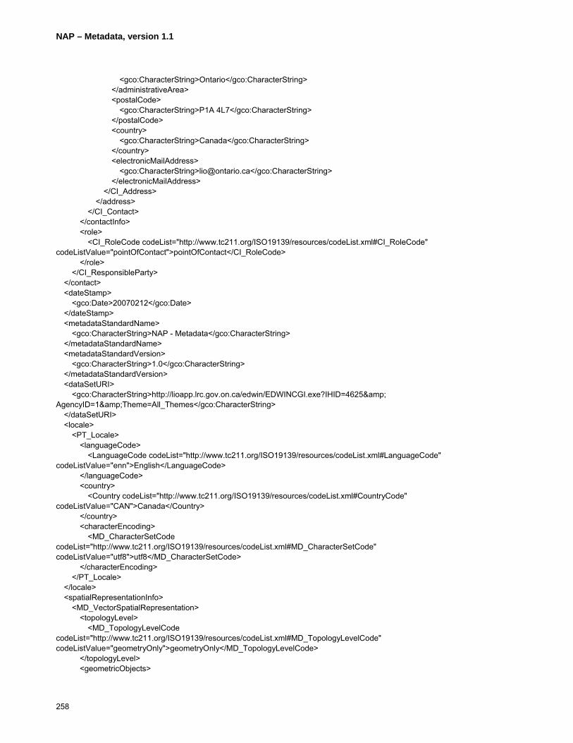
NAP – Metadata, version 1.1
258
<gco:CharacterString>Ontario</gco:CharacterString> </administrativeArea> <postalCode> <gco:CharacterString>P1A 4L7</gco:CharacterString> </postalCode> <country> <gco:CharacterString>Canada</gco:CharacterString> </country> <electronicMailAddress> <gco:CharacterString>[email protected]</gco:CharacterString> </electronicMailAddress> </CI_Address> </address> </CI_Contact> </contactInfo> <role> <CI_RoleCode codeList="http://www.tc211.org/ISO19139/resources/codeList.xml#CI_RoleCode" codeListValue="pointOfContact">pointOfContact</CI_RoleCode> </role> </CI_ResponsibleParty> </contact> <dateStamp> <gco:Date>20070212</gco:Date> </dateStamp> <metadataStandardName> <gco:CharacterString>NAP - Metadata</gco:CharacterString> </metadataStandardName> <metadataStandardVersion> <gco:CharacterString>1.0</gco:CharacterString> </metadataStandardVersion> <dataSetURI> <gco:CharacterString>http://lioapp.lrc.gov.on.ca/edwin/EDWINCGI.exe?IHID=4625& AgencyID=1&Theme=All_Themes</gco:CharacterString> </dataSetURI> <locale> <PT_Locale> <languageCode> <LanguageCode codeList="http://www.tc211.org/ISO19139/resources/codeList.xml#LanguageCode" codeListValue="enn">English</LanguageCode> </languageCode> <country> <Country codeList="http://www.tc211.org/ISO19139/resources/codeList.xml#CountryCode" codeListValue="CAN">Canada</Country> </country> <characterEncoding> <MD_CharacterSetCode codeList="http://www.tc211.org/ISO19139/resources/codeList.xml#MD_CharacterSetCode" codeListValue="utf8">utf8</MD_CharacterSetCode> </characterEncoding> </PT_Locale> </locale> <spatialRepresentationInfo> <MD_VectorSpatialRepresentation> <topologyLevel> <MD_TopologyLevelCode codeList="http://www.tc211.org/ISO19139/resources/codeList.xml#MD_TopologyLevelCode" codeListValue="geometryOnly">geometryOnly</MD_TopologyLevelCode> </topologyLevel> <geometricObjects>

NAP – Metadata, version 1.1
259
<MD_GeometricObjects> <geometricObjectType> <MD_GeometricObjectTypeCode codeList="http://www.tc211.org/ISO19139/resources/codeList.xml#MD_GeometricObjectTypeCode" codeListValue="point">point</MD_GeometricObjectTypeCode> </geometricObjectType> <geometricObjectCount> <gco:Integer>6308</gco:Integer> </geometricObjectCount> </MD_GeometricObjects> </geometricObjects> </MD_VectorSpatialRepresentation> </spatialRepresentationInfo> <referenceSystemInfo> <MD_ReferenceSystem> <referenceSystemIdentifier> <RS_Identifier> <code> <gco:CharacterString>NAD83</gco:CharacterString> </code> </RS_Identifier> </referenceSystemIdentifier> </MD_ReferenceSystem> </referenceSystemInfo> <identificationInfo> <MD_DataIdentification> <citation> <CI_Citation> <title> <gco:CharacterString>Great Blue Heron Nesting Site/Colony – North Bay OMNR District</gco:CharacterString> </title> <date> <CI_Date> <date> <gco:Date>19980619</gco:Date> </date> <dateType> <CI_DateTypeCode codeList="http://www.tc211.org/ISO19139/resources/codeList.xml#CI_DateTypeCode" codeListValue="creation">creation</CI_DateTypeCode> </dateType> </CI_Date> </date> <date> <CI_Date> <date> <gco:Date>20070212</gco:Date> </date> <dateType> <CI_DateTypeCode codeList="http://www.tc211.org/ISO19139/resources/codeList.xml#CI_DateTypeCode" codeListValue="revision">revision</CI_DateTypeCode> </dateType> </CI_Date> </date> <citedResponsibleParty> <CI_ResponsibleParty> <organisationName>
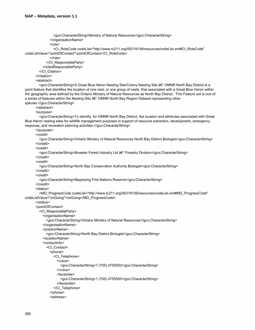
NAP – Metadata, version 1.1
260
<gco:CharacterString>Ministry of Natural Resources</gco:CharacterString> </organisationName> <role> <CI_RoleCode codeList="http://www.tc211.org/ISO19139/resources/codeList.xml#CI_RoleCode" codeListValue="pointOfContact">pointOfContact</CI_RoleCode> </role> </CI_ResponsibleParty> </citedResponsibleParty> </CI_Citation> </citation> <abstract> <gco:CharacterString>A Great Blue Heron Nesting Site/Colony Nesting Site – OMNR North Bay District is a point feature that identifies the location of one nest, or one group of nests, that associated with a Great Blue Heron within the geographic area defined by the Ontario Ministry of Natural Resources as North Bay District. This Feature set is one of a series of features within the Nesting Site – OMNR North Bay Region Dataset representing other species.</gco:CharacterString> </abstract> <purpose> <gco:CharacterString>To identify, for OMNR North Bay District, the location and attributes associated with Great Blue Heron nesting sites for wildlife management purposes in support of resource extraction, development, emergency response, and recreation planning activities.</gco:CharacterString> </purpose> <credit> <gco:CharacterString>Ontario Ministry of Natural Resources North Bay District Biologist</gco:CharacterString> </credit> <credit> <gco:CharacterString>Bowater Forest Industry Ltd – Forestry Division</gco:CharacterString> </credit> <credit> <gco:CharacterString>North Bay Conservation Authority Biologist</gco:CharacterString> </credit> <credit> <gco:CharacterString>Nippissing First Nations Reserve</gco:CharacterString> </credit> <status> <MD_ProgressCode codeList="http://www.tc211.org/ISO19139/resources/codeList.xml#MD_ProgressCode" codeListValue="onGoing">onGoing</MD_ProgressCode> </status> <pointOfContact> <CI_ResponsibleParty> <organisationName> <gco:CharacterString>Ontario Ministry of Natural Resources</gco:CharacterString> </organisationName> <positionName> <gco:CharacterString>North Bay District Biologist</gco:CharacterString> </positionName> <contactInfo> <CI_Contact> <phone> <CI_Telephone> <voice> <gco:CharacterString>1 (705) 4755550</gco:CharacterString> </voice> <facsimile> <gco:CharacterString>1 (705) 4755550</gco:CharacterString> </facsimile> </CI_Telephone> </phone> <address>

NAP – Metadata, version 1.1
261
<CI_Address> <deliveryPoint> <gco:CharacterString>physical; 3301; Trout Lake Road; ;</gco:CharacterString> </deliveryPoint> <city> <gco:CharacterString>North Bay</gco:CharacterString> </city> <administrativeArea> <gco:CharacterString>Ontario</gco:CharacterString> </administrativeArea> <postalCode> <gco:CharacterString>P1A 4L7</gco:CharacterString> </postalCode> <country> <gco:CharacterString>Canada</gco:CharacterString> </country> <electronicMailAddress> <gco:CharacterString>[email protected]</gco:CharacterString> </electronicMailAddress> </CI_Address> </address> </CI_Contact> </contactInfo> <role> <CI_RoleCode codeList="http://www.tc211.org/ISO19139/resources/codeList.xml#CI_RoleCode" codeListValue="custodian">custodian</CI_RoleCode> </role> </CI_ResponsibleParty> </pointOfContact> <resourceMaintenance> <MD_MaintenanceInformation> <maintenanceAndUpdateFrequency> <MD_MaintenanceFrequencyCode codeList="http://www.tc211.org/ISO19139/resources/codeList.xml#MD_MaintenanceFrequencyCode" codeListValue="continual">continual</MD_MaintenanceFrequencyCode> </maintenanceAndUpdateFrequency> <dateOfNextUpdate> <gco:Date>200706</gco:Date> </dateOfNextUpdate> <userDefinedMaintenanceFrequency> <gts:TM_PeriodDuration>P5Y</gts:TM_PeriodDuration> </userDefinedMaintenanceFrequency> <updateScope> <MD_ScopeCode codeList="http://www.tc211.org/ISO19139/resources/codeList.xml#MD_ScopeCode" codeListValue="attribute">attribute</MD_ScopeCode> </updateScope> <updateScopeDescription> <MD_ScopeDescription> <dataset> <gco:CharacterString>Nesting site data is acquired through general field collection activities, reports from the general public and information provided by external partners/agencies.</gco:CharacterString> </dataset> </MD_ScopeDescription> </updateScopeDescription> <maintenanceNote> <gco:CharacterString>Nests unoccupied for 5 years or more leads to Feature instance being “frozen� (not included for analysis or display).</gco:CharacterString> </maintenanceNote> <contact>
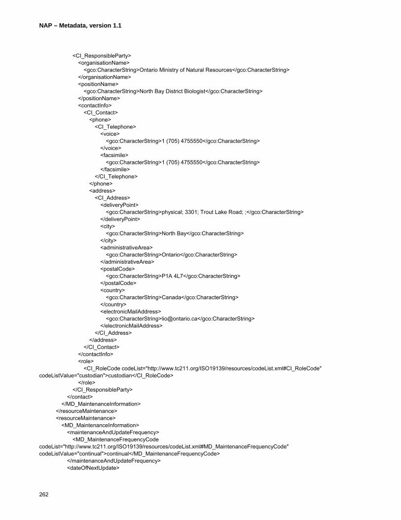
NAP – Metadata, version 1.1
262
<CI_ResponsibleParty> <organisationName> <gco:CharacterString>Ontario Ministry of Natural Resources</gco:CharacterString> </organisationName> <positionName> <gco:CharacterString>North Bay District Biologist</gco:CharacterString> </positionName> <contactInfo> <CI_Contact> <phone> <CI_Telephone> <voice> <gco:CharacterString>1 (705) 4755550</gco:CharacterString> </voice> <facsimile> <gco:CharacterString>1 (705) 4755550</gco:CharacterString> </facsimile> </CI_Telephone> </phone> <address> <CI_Address> <deliveryPoint> <gco:CharacterString>physical; 3301; Trout Lake Road; ;</gco:CharacterString> </deliveryPoint> <city> <gco:CharacterString>North Bay</gco:CharacterString> </city> <administrativeArea> <gco:CharacterString>Ontario</gco:CharacterString> </administrativeArea> <postalCode> <gco:CharacterString>P1A 4L7</gco:CharacterString> </postalCode> <country> <gco:CharacterString>Canada</gco:CharacterString> </country> <electronicMailAddress> <gco:CharacterString>[email protected]</gco:CharacterString> </electronicMailAddress> </CI_Address> </address> </CI_Contact> </contactInfo> <role> <CI_RoleCode codeList="http://www.tc211.org/ISO19139/resources/codeList.xml#CI_RoleCode" codeListValue="custodian">custodian</CI_RoleCode> </role> </CI_ResponsibleParty> </contact> </MD_MaintenanceInformation> </resourceMaintenance> <resourceMaintenance> <MD_MaintenanceInformation> <maintenanceAndUpdateFrequency> <MD_MaintenanceFrequencyCode codeList="http://www.tc211.org/ISO19139/resources/codeList.xml#MD_MaintenanceFrequencyCode" codeListValue="continual">continual</MD_MaintenanceFrequencyCode> </maintenanceAndUpdateFrequency> <dateOfNextUpdate>
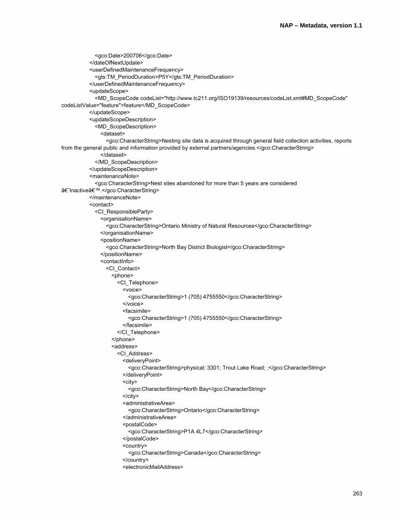
NAP – Metadata, version 1.1
263
<gco:Date>200706</gco:Date> </dateOfNextUpdate> <userDefinedMaintenanceFrequency> <gts:TM_PeriodDuration>P5Y</gts:TM_PeriodDuration> </userDefinedMaintenanceFrequency> <updateScope> <MD_ScopeCode codeList="http://www.tc211.org/ISO19139/resources/codeList.xml#MD_ScopeCode" codeListValue="feature">feature</MD_ScopeCode> </updateScope> <updateScopeDescription> <MD_ScopeDescription> <dataset> <gco:CharacterString>Nesting site data is acquired through general field collection activities, reports from the general public and information provided by external partners/agencies.</gco:CharacterString> </dataset> </MD_ScopeDescription> </updateScopeDescription> <maintenanceNote> <gco:CharacterString>Nest sites abandoned for more than 5 years are considered ‘Inactive’.</gco:CharacterString> </maintenanceNote> <contact> <CI_ResponsibleParty> <organisationName> <gco:CharacterString>Ontario Ministry of Natural Resources</gco:CharacterString> </organisationName> <positionName> <gco:CharacterString>North Bay District Biologist</gco:CharacterString> </positionName> <contactInfo> <CI_Contact> <phone> <CI_Telephone> <voice> <gco:CharacterString>1 (705) 4755550</gco:CharacterString> </voice> <facsimile> <gco:CharacterString>1 (705) 4755550</gco:CharacterString> </facsimile> </CI_Telephone> </phone> <address> <CI_Address> <deliveryPoint> <gco:CharacterString>physical; 3301; Trout Lake Road; ;</gco:CharacterString> </deliveryPoint> <city> <gco:CharacterString>North Bay</gco:CharacterString> </city> <administrativeArea> <gco:CharacterString>Ontario</gco:CharacterString> </administrativeArea> <postalCode> <gco:CharacterString>P1A 4L7</gco:CharacterString> </postalCode> <country> <gco:CharacterString>Canada</gco:CharacterString> </country> <electronicMailAddress>
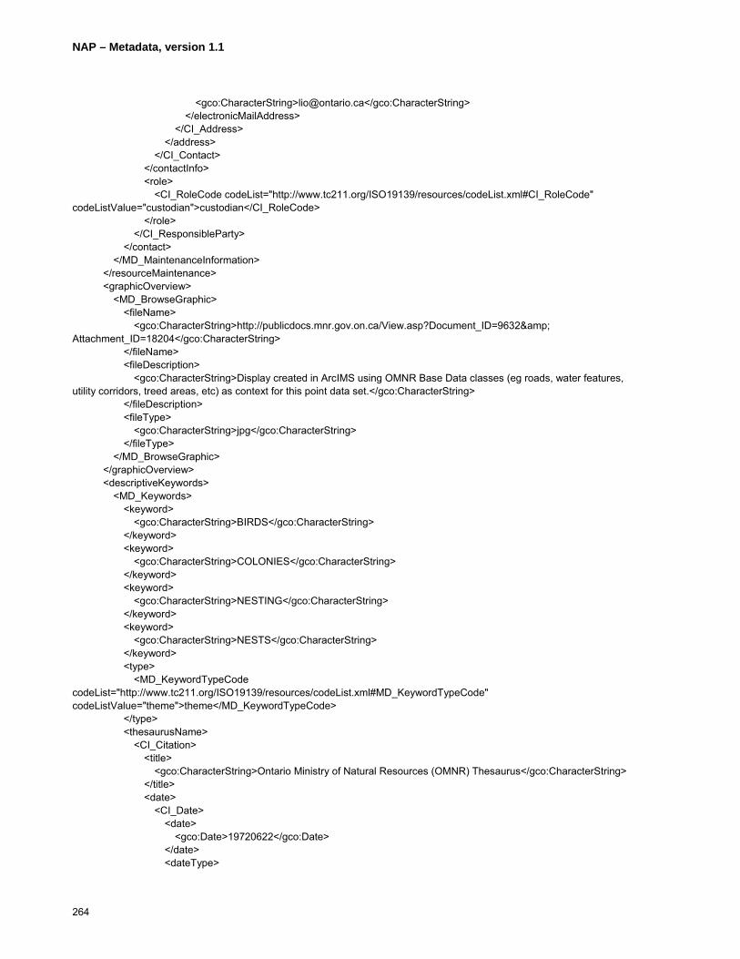
NAP – Metadata, version 1.1
264
<gco:CharacterString>[email protected]</gco:CharacterString> </electronicMailAddress> </CI_Address> </address> </CI_Contact> </contactInfo> <role> <CI_RoleCode codeList="http://www.tc211.org/ISO19139/resources/codeList.xml#CI_RoleCode" codeListValue="custodian">custodian</CI_RoleCode> </role> </CI_ResponsibleParty> </contact> </MD_MaintenanceInformation> </resourceMaintenance> <graphicOverview> <MD_BrowseGraphic> <fileName> <gco:CharacterString>http://publicdocs.mnr.gov.on.ca/View.asp?Document_ID=9632& Attachment_ID=18204</gco:CharacterString> </fileName> <fileDescription> <gco:CharacterString>Display created in ArcIMS using OMNR Base Data classes (eg roads, water features, utility corridors, treed areas, etc) as context for this point data set.</gco:CharacterString> </fileDescription> <fileType> <gco:CharacterString>jpg</gco:CharacterString> </fileType> </MD_BrowseGraphic> </graphicOverview> <descriptiveKeywords> <MD_Keywords> <keyword> <gco:CharacterString>BIRDS</gco:CharacterString> </keyword> <keyword> <gco:CharacterString>COLONIES</gco:CharacterString> </keyword> <keyword> <gco:CharacterString>NESTING</gco:CharacterString> </keyword> <keyword> <gco:CharacterString>NESTS</gco:CharacterString> </keyword> <type> <MD_KeywordTypeCode codeList="http://www.tc211.org/ISO19139/resources/codeList.xml#MD_KeywordTypeCode" codeListValue="theme">theme</MD_KeywordTypeCode> </type> <thesaurusName> <CI_Citation> <title> <gco:CharacterString>Ontario Ministry of Natural Resources (OMNR) Thesaurus</gco:CharacterString> </title> <date> <CI_Date> <date> <gco:Date>19720622</gco:Date> </date> <dateType>

NAP – Metadata, version 1.1
265
<CI_DateTypeCode codeList="http://www.tc211.org/ISO19139/resources/codeList.xml#CI_DateTypeCode" codeListValue="creation">creation</CI_DateTypeCode> </dateType> </CI_Date> </date> <date> <CI_Date> <date> <gco:Date>20060716</gco:Date> </date> <dateType> <CI_DateTypeCode codeList="http://www.tc211.org/ISO19139/resources/codeList.xml#CI_DateTypeCode" codeListValue="revision">revision</CI_DateTypeCode> </dateType> </CI_Date> </date> <edition> <gco:CharacterString>Originally created to catalogue documents stored in the OMNR library and since modified</gco:CharacterString> </edition> <citedResponsibleParty> <CI_ResponsibleParty> <organisationName> <gco:CharacterString>Ministry of Natural Resources</gco:CharacterString> </organisationName> <role> <CI_RoleCode codeList="http://www.tc211.org/ISO19139/resources/codeList.xml#CI_RoleCode" codeListValue="pointOfContact">pointOfContact</CI_RoleCode> </role> </CI_ResponsibleParty> </citedResponsibleParty> </CI_Citation> </thesaurusName> </MD_Keywords> </descriptiveKeywords> <descriptiveKeywords> <MD_Keywords> <keyword> <gco:CharacterString>FOREST MANAGEMENT</gco:CharacterString> </keyword> <keyword> <gco:CharacterString>FORESTRY</gco:CharacterString> </keyword> <keyword> <gco:CharacterString>LAND USE PLANNING</gco:CharacterString> </keyword> <keyword> <gco:CharacterString>MUNICIPAL PLANNING</gco:CharacterString> </keyword> <keyword> <gco:CharacterString>WILDLIFE</gco:CharacterString> </keyword> <type> <MD_KeywordTypeCode codeList="http://www.tc211.org/ISO19139/resources/codeList.xml#MD_KeywordTypeCode" codeListValue="discipline">discipline</MD_KeywordTypeCode> </type>

NAP – Metadata, version 1.1
266
<thesaurusName> <CI_Citation> <title> <gco:CharacterString>Ontario Ministry of Natural Resources (OMNR) Thesaurus</gco:CharacterString> </title> <date> <CI_Date> <date> <gco:Date>19720622</gco:Date> </date> <dateType> <CI_DateTypeCode codeList="http://www.tc211.org/ISO19139/resources/codeList.xml#CI_DateTypeCode" codeListValue="creation">creation</CI_DateTypeCode> </dateType> </CI_Date> </date> <date> <CI_Date> <date> <gco:Date>20060716</gco:Date> </date> <dateType> <CI_DateTypeCode codeList="http://www.tc211.org/ISO19139/resources/codeList.xml#CI_DateTypeCode" codeListValue="revision">revision</CI_DateTypeCode> </dateType> </CI_Date> </date> <edition> <gco:CharacterString>Originally created to catalogue documents stored in the OMNR library and since modified.</gco:CharacterString> </edition> <citedResponsibleParty> <CI_ResponsibleParty> <organisationName> <gco:CharacterString>Ministry of Natural Resources</gco:CharacterString> </organisationName> <role> <CI_RoleCode codeList="http://www.tc211.org/ISO19139/resources/codeList.xml#CI_RoleCode" codeListValue="pointOfContact">pointOfContact</CI_RoleCode> </role> </CI_ResponsibleParty> </citedResponsibleParty> </CI_Citation> </thesaurusName> </MD_Keywords> </descriptiveKeywords> <descriptiveKeywords> <MD_Keywords> <keyword> <gco:CharacterString>ONTARIO</gco:CharacterString> </keyword> <keyword> <gco:CharacterString>NORTH BAY OMNR DISTRICT</gco:CharacterString> </keyword> <type>
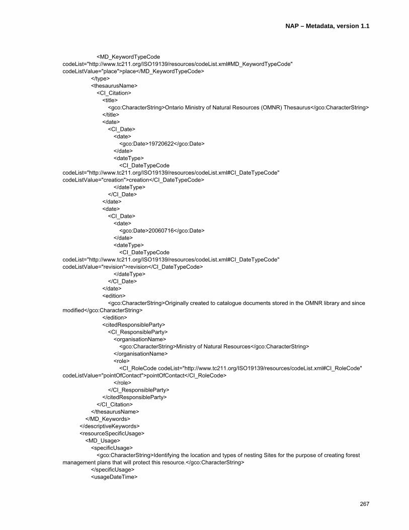
NAP – Metadata, version 1.1
267
<MD_KeywordTypeCode codeList="http://www.tc211.org/ISO19139/resources/codeList.xml#MD_KeywordTypeCode" codeListValue="place">place</MD_KeywordTypeCode> </type> <thesaurusName> <CI_Citation> <title> <gco:CharacterString>Ontario Ministry of Natural Resources (OMNR) Thesaurus</gco:CharacterString> </title> <date> <CI_Date> <date> <gco:Date>19720622</gco:Date> </date> <dateType> <CI_DateTypeCode codeList="http://www.tc211.org/ISO19139/resources/codeList.xml#CI_DateTypeCode" codeListValue="creation">creation</CI_DateTypeCode> </dateType> </CI_Date> </date> <date> <CI_Date> <date> <gco:Date>20060716</gco:Date> </date> <dateType> <CI_DateTypeCode codeList="http://www.tc211.org/ISO19139/resources/codeList.xml#CI_DateTypeCode" codeListValue="revision">revision</CI_DateTypeCode> </dateType> </CI_Date> </date> <edition> <gco:CharacterString>Originally created to catalogue documents stored in the OMNR library and since modified</gco:CharacterString> </edition> <citedResponsibleParty> <CI_ResponsibleParty> <organisationName> <gco:CharacterString>Ministry of Natural Resources</gco:CharacterString> </organisationName> <role> <CI_RoleCode codeList="http://www.tc211.org/ISO19139/resources/codeList.xml#CI_RoleCode" codeListValue="pointOfContact">pointOfContact</CI_RoleCode> </role> </CI_ResponsibleParty> </citedResponsibleParty> </CI_Citation> </thesaurusName> </MD_Keywords> </descriptiveKeywords> <resourceSpecificUsage> <MD_Usage> <specificUsage> <gco:CharacterString>Identifying the location and types of nesting Sites for the purpose of creating forest management plans that will protect this resource.</gco:CharacterString> </specificUsage> <usageDateTime>

NAP – Metadata, version 1.1
268
<gco:DateTime>2000-03-25T00:00:00</gco:DateTime> </usageDateTime> <userDeterminedLimitations> <gco:CharacterString>Not intended for display at greater than 1:5000 or analysis requiring geographic accuracy of better than 10 m. Intended for display in conjunction with Ontario Ministry of Natural Resources (OMNR) Base Data Series of data sets and may not align with other data sets.</gco:CharacterString> </userDeterminedLimitations> <userContactInfo> <CI_ResponsibleParty> <organisationName> <gco:CharacterString>Ministry of Natural Resources</gco:CharacterString> </organisationName> <positionName> <gco:CharacterString>Land Information Ontario Support</gco:CharacterString> </positionName> <contactInfo> <CI_Contact> <phone> <CI_Telephone> <voice> <gco:CharacterString>1(705) 7551878</gco:CharacterString> </voice> <facsimile> <gco:CharacterString>1 (705) 7551677</gco:CharacterString> </facsimile> </CI_Telephone> </phone> <address> <CI_Address> <deliveryPoint> <gco:CharacterString>physical; 300; Water Street; ;</gco:CharacterString> </deliveryPoint> <city> <gco:CharacterString>Peterborough</gco:CharacterString> </city> <administrativeArea> <gco:CharacterString>Ontario</gco:CharacterString> </administrativeArea> <postalCode> <gco:CharacterString>K7J 8M5</gco:CharacterString> </postalCode> <country> <gco:CharacterString>Canada</gco:CharacterString> </country> <electronicMailAddress> <gco:CharacterString>[email protected]</gco:CharacterString> </electronicMailAddress> </CI_Address> </address> </CI_Contact> </contactInfo> <role> <CI_RoleCode codeList="http://www.tc211.org/ISO19139/resources/codeList.xml#CI_RoleCode" codeListValue="pointOfContact">pointOfContact</CI_RoleCode> </role> </CI_ResponsibleParty> </userContactInfo> </MD_Usage> </resourceSpecificUsage>

NAP – Metadata, version 1.1
269
<resourceSpecificUsage> <MD_Usage> <specificUsage> <gco:CharacterString>Identifying the location and types of nesting Sites for the purpose of increasing wildlife habitat and biodiversity through various initiatives.</gco:CharacterString> </specificUsage> <usageDateTime> <gco:DateTime>2004-05-26T00:00:00</gco:DateTime> </usageDateTime> <userDeterminedLimitations> <gco:CharacterString>Not intended for display at greater than 1:5000 or analysis requiring geographic accuracy of better than 10 m. Intended for display in conjunction with Ontario Ministry of Natural Resources (OMNR) Base Data Series of data sets and may not align with other data sets.</gco:CharacterString> </userDeterminedLimitations> <userContactInfo> <CI_ResponsibleParty> <organisationName> <gco:CharacterString>Ministry of Natural Resources</gco:CharacterString> </organisationName> <positionName> <gco:CharacterString>Land Information Ontario Support</gco:CharacterString> </positionName> <contactInfo> <CI_Contact> <phone> <CI_Telephone> <voice> <gco:CharacterString>1(705) 7551878</gco:CharacterString> </voice> <facsimile> <gco:CharacterString>1 (705) 7551677</gco:CharacterString> </facsimile> </CI_Telephone> </phone> <address> <CI_Address> <deliveryPoint> <gco:CharacterString>physical; 300; Water Street; ;</gco:CharacterString> </deliveryPoint> <city> <gco:CharacterString>Peterborough</gco:CharacterString> </city> <administrativeArea> <gco:CharacterString>Ontario</gco:CharacterString> </administrativeArea> <postalCode> <gco:CharacterString>K7J 8M5</gco:CharacterString> </postalCode> <country> <gco:CharacterString>Canada</gco:CharacterString> </country> <electronicMailAddress> <gco:CharacterString>[email protected]</gco:CharacterString> </electronicMailAddress> </CI_Address> </address> </CI_Contact> </contactInfo> <role>

NAP – Metadata, version 1.1
270
<CI_RoleCode codeList="http://www.tc211.org/ISO19139/resources/codeList.xml#CI_RoleCode" codeListValue="pointOfContact">pointOfContact</CI_RoleCode> </role> </CI_ResponsibleParty> </userContactInfo> </MD_Usage> </resourceSpecificUsage> <resourceConstraints> <MD_Constraints> <useLimitation> <gco:CharacterString>This information holding is not to be used for Legal Purposes.</gco:CharacterString> </useLimitation> <useLimitation> <gco:CharacterString>Statutory: This Information holding is to be used only for the purposes for which it was collected. Use must be in accordance with the terms of the licence issued by the Ontario Ministry of Natural Resources.</gco:CharacterString> </useLimitation> <useLimitation> <gco:CharacterString>Sensitivity: Although generally available to the public, some of the information in this information holding may be considered sensitive and, as such, access to the holding may, in whole or in part, be restricted to authorized individuals and/or organizations in accordance with the Ontario Rare and Endangered Species Act 2003. For more information, see Selected Wildlife and Habitat Features>Inventory Manual, W. B. Ranta, Kenora District, Section 2.2d. A list of authorized users is available from the Ontario Ministry of Natural Resources (OMNR) Information Access unit.</gco:CharacterString> </useLimitation> <useLimitation> <gco:CharacterString>Privacy: There are no known privacy concerns in this information holding.</gco:CharacterString> </useLimitation> </MD_Constraints> </resourceConstraints> <resourceConstraints> <MD_LegalConstraints> <accessConstraints> <MD_RestrictionCode codeList="http://www.tc211.org/ISO19139/resources/codeList.xml#MD_RestrictionCode" codeListValue="otherRestrictions">otherRestrictions</MD_RestrictionCode> </accessConstraints> <useConstraints> <MD_RestrictionCode codeList="http://www.tc211.org/ISO19139/resources/codeList.xml#MD_RestrictionCode" codeListValue="license">license</MD_RestrictionCode> </useConstraints> </MD_LegalConstraints> </resourceConstraints> <resourceConstraints> <MD_SecurityConstraints> <classification> <MD_ClassificationCode codeList="http://www.tc211.org/ISO19139/resources/codeList.xml#MD_ClassificationCode" codeListValue="unclassified">unclassified</MD_ClassificationCode> </classification> </MD_SecurityConstraints> </resourceConstraints> <aggregationInfo> <MD_AggregateInformation> <aggregateDataSetName> <CI_Citation> <title>

NAP – Metadata, version 1.1
271
<gco:CharacterString>Nesting Site Province</gco:CharacterString> </title> <date> <CI_Date> <date> <gco:Date>20070719</gco:Date> </date> <dateType> <CI_DateTypeCode codeList="http://www.tc211.org/ISO19139/resources/codeList.xml#CI_DateTypeCode" codeListValue="creation">creation</CI_DateTypeCode> </dateType> </CI_Date> </date> <citedResponsibleParty> <CI_ResponsibleParty> <organisationName> <gco:CharacterString>Ontario Ministry of Natural Resources</gco:CharacterString> </organisationName> <role> <CI_RoleCode codeList="http://www.tc211.org/ISO19139/resources/codeList.xml#CI_RoleCode" codeListValue="resourceProvider">resourceProvider</CI_RoleCode> </role> </CI_ResponsibleParty> </citedResponsibleParty> <presentationForm> <CI_PresentationFormCode codeList="http://www.tc211.org/ISO19139/resources/codeList.xml#CI_PresentationFormCode" codeListValue="mapDigital">mapDigital</CI_PresentationFormCode> </presentationForm> <series> <CI_Series> <name> <gco:CharacterString>Nesting Site Province</gco:CharacterString> </name> </CI_Series> </series> </CI_Citation> </aggregateDataSetName> <aggregateDataSetIdentifier> <MD_Identifier> <code> <gco:CharacterString>http://lioapp.lrc.gov.on.ca/edwin/EDWINCGI.exe?IHID=771&AgencyID=1&Theme=All_Themes</gco:CharacterString> </code> </MD_Identifier> </aggregateDataSetIdentifier> <associationType> <DS_AssociationTypeCode codeList="http://www.tc211.org/ISO19139/resources/codeList.xml#DS_AssociationTypeCode" codeListValue="partofSeamlessDatabase">partofSeamlessDatabase</DS_AssociationTypeCode> </associationType> <initiativeType> <DS_InitiativeTypeCode codeList="http://www.tc211.org/ISO19139/resources/codeList.xml#DS_InitiativeTypeCode" codeListValue="collection">collection</DS_InitiativeTypeCode> </initiativeType> </MD_AggregateInformation>

NAP – Metadata, version 1.1
272
</aggregationInfo> <spatialRepresentationType> <MD_SpatialRepresentationTypeCode codeList="http://www.tc211.org/ISO19139/resources/codeList.xml#MD_SpatialRepresentationTypeCode" codeListValue="vector">vector</MD_SpatialRepresentationTypeCode> </spatialRepresentationType> <spatialResolution> <MD_Resolution> <equivalentScale> <MD_RepresentativeFraction> <denominator> <gco:Integer>20000</gco:Integer> </denominator> </MD_RepresentativeFraction> </equivalentScale> </MD_Resolution> </spatialResolution> <spatialResolution> <MD_Resolution> <distance> <gco:Distance uom="metre">10</gco:Distance> </distance> </MD_Resolution> </spatialResolution> <language> <gco:CharacterString>eng</gco:CharacterString> </language> <language> <gco:CharacterString>fra</gco:CharacterString> </language> <language> <gco:CharacterString>cre</gco:CharacterString> </language> <characterSet> <MD_CharacterSetCode codeList="http://www.tc211.org/ISO19139/resources/codeList.xml#MD_CharacterSetCode" codeListValue="utf8">utf8</MD_CharacterSetCode> </characterSet> <topicCategory> <MD_TopicCategoryCode>biota</MD_TopicCategoryCode> </topicCategory> <environmentDescription> <gco:CharacterString>Spatial locations and attributes are maintained by the OMNR's Natural Resources Values Information System (NRVIS), a custom instance of ESRI ArcGIS 9.x supported by Oracle DBMS</gco:CharacterString> </environmentDescription> <extent> <EX_Extent> <geographicElement> <EX_BoundingPolygon> <extentTypeCode> <gco:Boolean>1</gco:Boolean> </extentTypeCode> <polygon/> </EX_BoundingPolygon> </geographicElement> <geographicElement> <EX_GeographicBoundingBox> <extentTypeCode> <gco:Boolean>1</gco:Boolean>

NAP – Metadata, version 1.1
273
</extentTypeCode> <westBoundLongitude> <gco:Decimal>-80.5</gco:Decimal> </westBoundLongitude> <eastBoundLongitude> <gco:Decimal>-78.2</gco:Decimal> </eastBoundLongitude> <southBoundLatitude> <gco:Decimal>45.5</gco:Decimal> </southBoundLatitude> <northBoundLatitude> <gco:Decimal>47.3</gco:Decimal> </northBoundLatitude> </EX_GeographicBoundingBox> </geographicElement> </EX_Extent> </extent> </MD_DataIdentification> </identificationInfo> <identificationInfo> <srv:SV_ServiceIdentification> <citation> <CI_Citation> <title> <gco:CharacterString>Habitat Web Map Service (WMS)</gco:CharacterString> </title> <date> <CI_Date> <date> <gco:Date>20050101</gco:Date> </date> <dateType> <CI_DateTypeCode codeList="http://www.tc211.org/ISO19139/resources/codeList.xml#CI_DateTypeCode" codeListValue="creation">creation</CI_DateTypeCode> </dateType> </CI_Date> </date> <citedResponsibleParty> <CI_ResponsibleParty> <organisationName> <gco:CharacterString>Ontario Ministry of Natural Resources – Land Information Ontario</gco:CharacterString> </organisationName> <contactInfo> <CI_Contact> <phone> <CI_Telephone> <voice> <gco:CharacterString>1(705) 7551878</gco:CharacterString> </voice> <facsimile> <gco:CharacterString>1 (705) 7551677</gco:CharacterString> </facsimile> </CI_Telephone> </phone> <address> <CI_Address> <deliveryPoint>
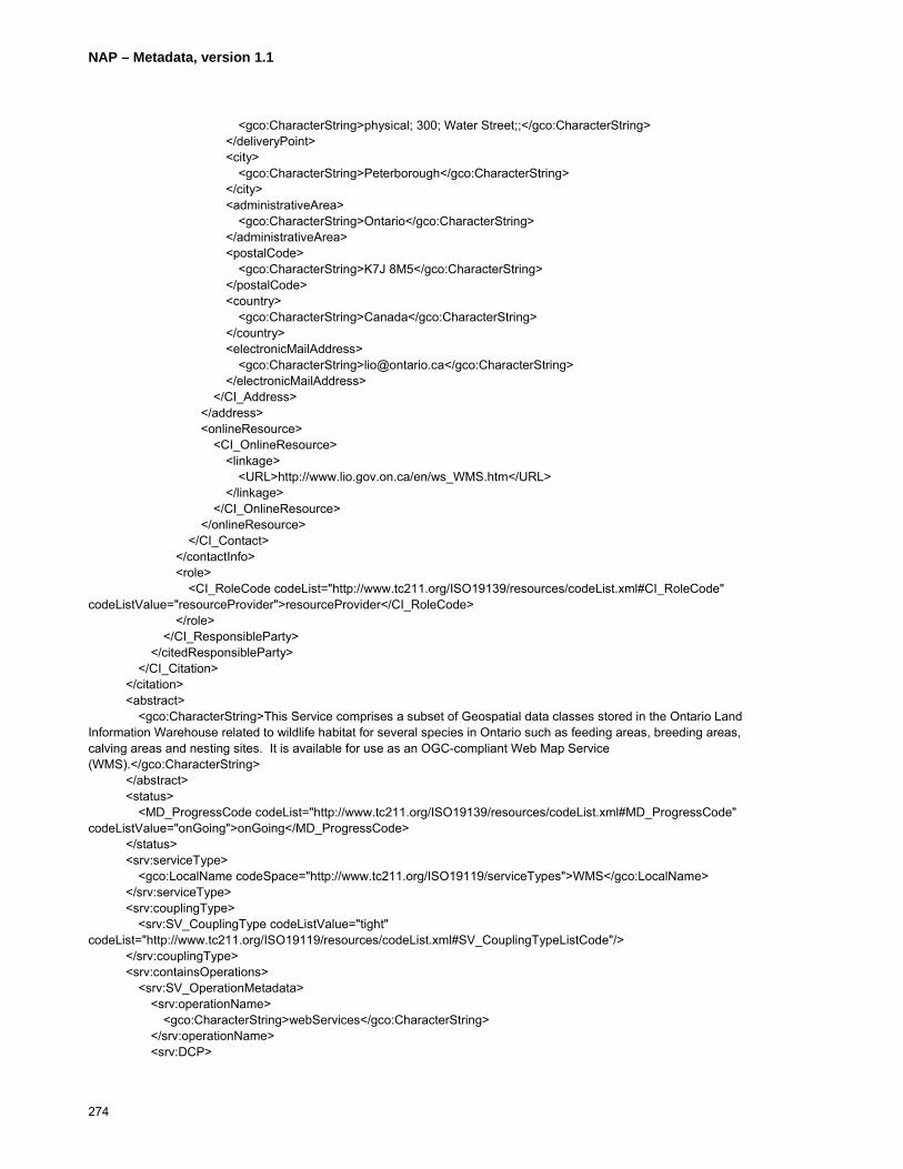
NAP – Metadata, version 1.1
274
<gco:CharacterString>physical; 300; Water Street;;</gco:CharacterString> </deliveryPoint> <city> <gco:CharacterString>Peterborough</gco:CharacterString> </city> <administrativeArea> <gco:CharacterString>Ontario</gco:CharacterString> </administrativeArea> <postalCode> <gco:CharacterString>K7J 8M5</gco:CharacterString> </postalCode> <country> <gco:CharacterString>Canada</gco:CharacterString> </country> <electronicMailAddress> <gco:CharacterString>[email protected]</gco:CharacterString> </electronicMailAddress> </CI_Address> </address> <onlineResource> <CI_OnlineResource> <linkage> <URL>http://www.lio.gov.on.ca/en/ws_WMS.htm</URL> </linkage> </CI_OnlineResource> </onlineResource> </CI_Contact> </contactInfo> <role> <CI_RoleCode codeList="http://www.tc211.org/ISO19139/resources/codeList.xml#CI_RoleCode" codeListValue="resourceProvider">resourceProvider</CI_RoleCode> </role> </CI_ResponsibleParty> </citedResponsibleParty> </CI_Citation> </citation> <abstract> <gco:CharacterString>This Service comprises a subset of Geospatial data classes stored in the Ontario Land Information Warehouse related to wildlife habitat for several species in Ontario such as feeding areas, breeding areas, calving areas and nesting sites. It is available for use as an OGC-compliant Web Map Service (WMS).</gco:CharacterString> </abstract> <status> <MD_ProgressCode codeList="http://www.tc211.org/ISO19139/resources/codeList.xml#MD_ProgressCode" codeListValue="onGoing">onGoing</MD_ProgressCode> </status> <srv:serviceType> <gco:LocalName codeSpace="http://www.tc211.org/ISO19119/serviceTypes">WMS</gco:LocalName> </srv:serviceType> <srv:couplingType> <srv:SV_CouplingType codeListValue="tight" codeList="http://www.tc211.org/ISO19119/resources/codeList.xml#SV_CouplingTypeListCode"/> </srv:couplingType> <srv:containsOperations> <srv:SV_OperationMetadata> <srv:operationName> <gco:CharacterString>webServices</gco:CharacterString> </srv:operationName> <srv:DCP>
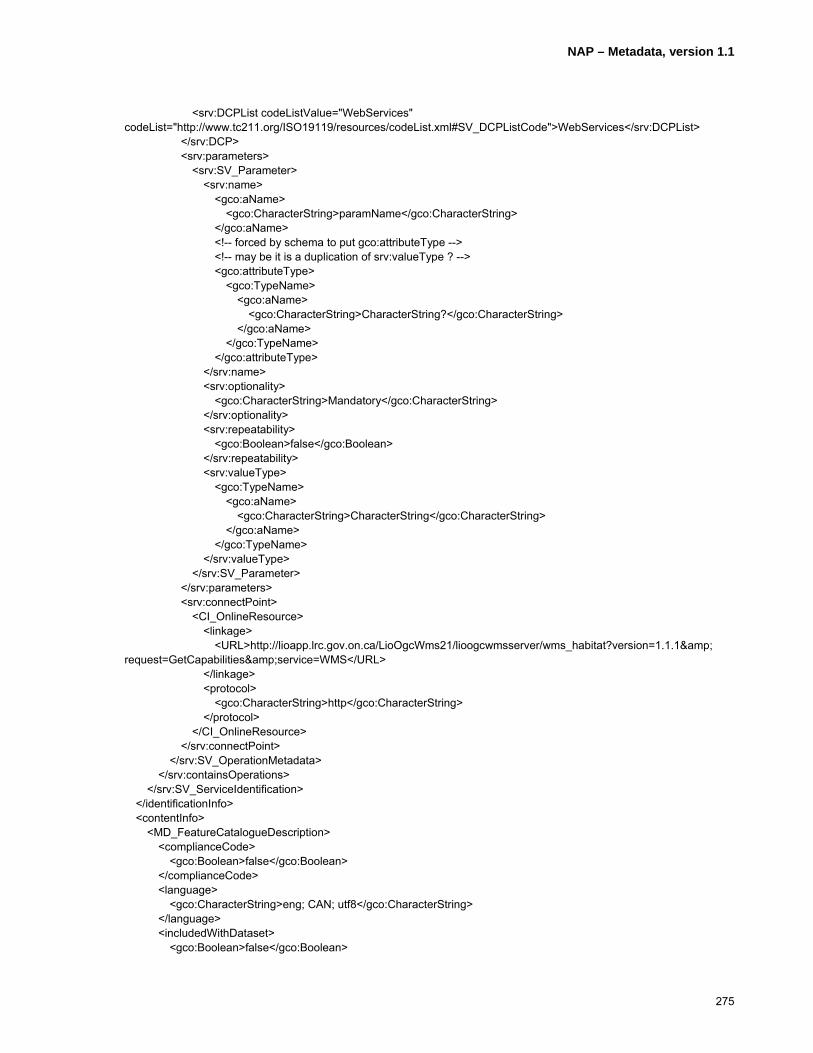
NAP – Metadata, version 1.1
275
<srv:DCPList codeListValue="WebServices" codeList="http://www.tc211.org/ISO19119/resources/codeList.xml#SV_DCPListCode">WebServices</srv:DCPList> </srv:DCP> <srv:parameters> <srv:SV_Parameter> <srv:name> <gco:aName> <gco:CharacterString>paramName</gco:CharacterString> </gco:aName> <!-- forced by schema to put gco:attributeType --> <!-- may be it is a duplication of srv:valueType ? --> <gco:attributeType> <gco:TypeName> <gco:aName> <gco:CharacterString>CharacterString?</gco:CharacterString> </gco:aName> </gco:TypeName> </gco:attributeType> </srv:name> <srv:optionality> <gco:CharacterString>Mandatory</gco:CharacterString> </srv:optionality> <srv:repeatability> <gco:Boolean>false</gco:Boolean> </srv:repeatability> <srv:valueType> <gco:TypeName> <gco:aName> <gco:CharacterString>CharacterString</gco:CharacterString> </gco:aName> </gco:TypeName> </srv:valueType> </srv:SV_Parameter> </srv:parameters> <srv:connectPoint> <CI_OnlineResource> <linkage> <URL>http://lioapp.lrc.gov.on.ca/LioOgcWms21/lioogcwmsserver/wms_habitat?version=1.1.1& request=GetCapabilities&service=WMS</URL> </linkage> <protocol> <gco:CharacterString>http</gco:CharacterString> </protocol> </CI_OnlineResource> </srv:connectPoint> </srv:SV_OperationMetadata> </srv:containsOperations> </srv:SV_ServiceIdentification> </identificationInfo> <contentInfo> <MD_FeatureCatalogueDescription> <complianceCode> <gco:Boolean>false</gco:Boolean> </complianceCode> <language> <gco:CharacterString>eng; CAN; utf8</gco:CharacterString> </language> <includedWithDataset> <gco:Boolean>false</gco:Boolean>

NAP – Metadata, version 1.1
276
</includedWithDataset> <featureTypes> <gco:LocalName>1100 Great Blue Heron Nesting Site/Colony</gco:LocalName> </featureTypes> <featureCatalogueCitation> <CI_Citation> <title> <gco:CharacterString>Standard NRVIS Interchange Format (SNIF) Report – ‘Nesting Site’</gco:CharacterString> </title> <alternateTitle> <gco:CharacterString>SNIF Report – ‘Nesting Site’</gco:CharacterString> </alternateTitle> <date> <CI_Date> <date> <gco:Date>20060620</gco:Date> </date> <dateType> <CI_DateTypeCode codeList="http://www.tc211.org/ISO19139/resources/codeList.xml#CI_DateTypeCode" codeListValue="revision">revision</CI_DateTypeCode> </dateType> </CI_Date> </date> <edition> <gco:CharacterString>SNIF Version 2.0</gco:CharacterString> </edition> <editionDate> <gco:Date>20030522</gco:Date> </editionDate> <citedResponsibleParty> <CI_ResponsibleParty> <organisationName> <gco:CharacterString>Ministry of Natural Resources</gco:CharacterString> </organisationName> <positionName> <gco:CharacterString>Land Information Ontario Support</gco:CharacterString> </positionName> <contactInfo> <CI_Contact> <phone> <CI_Telephone> <voice> <gco:CharacterString>1 (705) 7551878</gco:CharacterString> </voice> <facsimile> <gco:CharacterString>1 (705) 7551677</gco:CharacterString> </facsimile> </CI_Telephone> </phone> <address> <CI_Address> <deliveryPoint> <gco:CharacterString>physical; 300; Water Street; ;</gco:CharacterString> </deliveryPoint> <city> <gco:CharacterString>Peterborough</gco:CharacterString> </city>

NAP – Metadata, version 1.1
277
<administrativeArea> <gco:CharacterString>Ontario</gco:CharacterString> </administrativeArea> <postalCode> <gco:CharacterString>K7J 8M5</gco:CharacterString> </postalCode> <country> <gco:CharacterString>Canada</gco:CharacterString> </country> <electronicMailAddress> <gco:CharacterString>[email protected]</gco:CharacterString> </electronicMailAddress> </CI_Address> </address> <onlineResource> <CI_OnlineResource> <linkage> <URL>http://publicdocs.mnr.gov.on.ca/View.asp?Document_ID=8874& Attachment_ID=16787</URL> </linkage> <description> <gco:CharacterString>Detailed description of data dictionary and data model.</gco:CharacterString> </description> </CI_OnlineResource> </onlineResource> </CI_Contact> </contactInfo> <role> <CI_RoleCode codeList="http://www.tc211.org/ISO19139/resources/codeList.xml#CI_RoleCode" codeListValue="pointOfContact">pointOfContact</CI_RoleCode> </role> </CI_ResponsibleParty> </citedResponsibleParty> </CI_Citation> </featureCatalogueCitation> </MD_FeatureCatalogueDescription> </contentInfo> <distributionInfo> <MD_Distribution> <distributionFormat> <MD_Format> <name> <gco:CharacterString>ESRI ARC/INFO Coverage</gco:CharacterString> </name> <version> <gco:CharacterString>ArcGIS 8.3</gco:CharacterString> </version> </MD_Format> </distributionFormat> <distributionFormat> <MD_Format> <name> <gco:CharacterString>ESRI Shapefile</gco:CharacterString> </name> <version> <gco:CharacterString>ArcGIS 8.3</gco:CharacterString> </version> </MD_Format>

NAP – Metadata, version 1.1
278
</distributionFormat> <distributionFormat> <MD_Format> <name> <gco:CharacterString>ESRI ARC/INFO Export (.e00)</gco:CharacterString> </name> <version> <gco:CharacterString>ArcGIS 8.3</gco:CharacterString> </version> </MD_Format> </distributionFormat> <distributionFormat> <MD_Format> <name> <gco:CharacterString>MNR NRVIS-Lite</gco:CharacterString> </name> <version> <gco:CharacterString>2.1</gco:CharacterString> </version> </MD_Format> </distributionFormat> <distributor> <MD_Distributor> <distributorContact> <CI_ResponsibleParty> <contactInfo> <CI_Contact> <phone> <CI_Telephone> <voice> <gco:CharacterString>1 (705) 7551878</gco:CharacterString> </voice> <facsimile> <gco:CharacterString>1 (705) 7551677</gco:CharacterString> </facsimile> </CI_Telephone> </phone> <address> <CI_Address> <deliveryPoint> <gco:CharacterString>physical; 300; Water Street; ;</gco:CharacterString> </deliveryPoint> <city> <gco:CharacterString>Peterborough</gco:CharacterString> </city> <administrativeArea> <gco:CharacterString>Ontario</gco:CharacterString> </administrativeArea> <postalCode> <gco:CharacterString>K7J 8M5</gco:CharacterString> </postalCode> <country> <gco:CharacterString>Canada</gco:CharacterString> </country> <electronicMailAddress> <gco:CharacterString>[email protected]</gco:CharacterString> </electronicMailAddress> </CI_Address> </address>

NAP – Metadata, version 1.1
279
</CI_Contact> </contactInfo> <role> <CI_RoleCode codeList="http://www.tc211.org/ISO19139/resources/codeList.xml#CI_RoleCode" codeListValue="distributor">distributor</CI_RoleCode> </role> </CI_ResponsibleParty> </distributorContact> </MD_Distributor> </distributor> <transferOptions> <MD_DigitalTransferOptions> <offLine> <MD_Medium> <name> <MD_MediumNameCode codeList="http://www.tc211.org/ISO19139/resources/codeList.xml#MD_MediumNameCode" codeListValue="cdRom">cdRom</MD_MediumNameCode> </name> </MD_Medium> </offLine> </MD_DigitalTransferOptions> </transferOptions> <transferOptions> <MD_DigitalTransferOptions> <offLine> <MD_Medium> <name> <MD_MediumNameCode codeList="http://www.tc211.org/ISO19139/resources/codeList.xml#MD_MediumNameCode" codeListValue="dvdRom">dvdRom</MD_MediumNameCode> </name> </MD_Medium> </offLine> </MD_DigitalTransferOptions> </transferOptions> </MD_Distribution> </distributionInfo> <dataQualityInfo> <DQ_DataQuality> <scope> <DQ_Scope> <level> <MD_ScopeCode codeList="http://www.tc211.org/ISO19139/resources/codeList.xml#MD_ScopeCode" codeListValue="series">series</MD_ScopeCode> </level> </DQ_Scope> </scope> <lineage> <LI_Lineage> <statement> <gco:CharacterString>Data is collected and maintained by Ontario Ministry of Natural Resources (OMNR) Districts using the Natural Resources Values Information System (NRVIS).</gco:CharacterString> </statement> <processStep> <LI_ProcessStep> <description> <gco:CharacterString>Investigation by OMNR staff biologists via GPS and remote GIS devices both on the ground and by helicopter.</gco:CharacterString>

NAP – Metadata, version 1.1
280
</description> <rationale> <gco:CharacterString>Periodic update</gco:CharacterString> </rationale> <dateTime> <gco:DateTime>2006-04-15T00:00:00</gco:DateTime> </dateTime> </LI_ProcessStep> </processStep> <source> <LI_Source> <description> <gco:CharacterString>The Nesting Site data was compiled from various sources including direct collection by Ontario Ministry of Natural Resources (OMNR) biologists via GPS and in some cases sketches based on observations. Some of the data may have been taken from vintage Ontario Base Maps (circa 1972-1985). The Nesting Site data class is a point class and should be used with one or more OMNR Base Data classes in order to provide an appropriate relative geographic reference.</gco:CharacterString> </description> </LI_Source> </source> </LI_Lineage> </lineage> </DQ_DataQuality> </dataQualityInfo> <metadataMaintenance> <MD_MaintenanceInformation> <maintenanceAndUpdateFrequency> <MD_MaintenanceFrequencyCode codeList="http://www.tc211.org/ISO19139/resources/codeList.xml#MD_MaintenanceFrequencyCode" codeListValue="annually">annually</MD_MaintenanceFrequencyCode> </maintenanceAndUpdateFrequency> <dateOfNextUpdate> <gco:Date>20080215</gco:Date> </dateOfNextUpdate> <updateScope> <MD_ScopeCode codeList="http://www.tc211.org/ISO19139/resources/codeList.xml#MD_ScopeCode" codeListValue="feature">feature</MD_ScopeCode> </updateScope> <updateScopeDescription> <MD_ScopeDescription> <dataset> <gco:CharacterString>Update activity checks for changes to any aspect of the Features in the dataset and adds, modifies, or deletes elements in the Metadata record accordingly.</gco:CharacterString> </dataset> </MD_ScopeDescription> </updateScopeDescription> <contact> <CI_ResponsibleParty> <organisationName> <gco:CharacterString>Ontario Ministry of Natural Resources</gco:CharacterString> </organisationName> <positionName> <gco:CharacterString>North Bay District Biologist</gco:CharacterString> </positionName> <contactInfo> <CI_Contact> <phone> <CI_Telephone> <voice>

NAP – Metadata, version 1.1
281
<gco:CharacterString>1 (705) 4755550</gco:CharacterString> </voice> <facsimile> <gco:CharacterString>1 (705) 4755550</gco:CharacterString> </facsimile> </CI_Telephone> </phone> <address> <CI_Address> <deliveryPoint> <gco:CharacterString>physical; 3301; Trout Lake Road; ;</gco:CharacterString> </deliveryPoint> <city> <gco:CharacterString>North Bay</gco:CharacterString> </city> <administrativeArea> <gco:CharacterString>Ontario</gco:CharacterString> </administrativeArea> <postalCode> <gco:CharacterString>P1A 4L7</gco:CharacterString> </postalCode> <country> <gco:CharacterString>Canada</gco:CharacterString> </country> <electronicMailAddress> <gco:CharacterString>[email protected]</gco:CharacterString> </electronicMailAddress> </CI_Address> </address> </CI_Contact> </contactInfo> <role> <CI_RoleCode codeList="http://www.tc211.org/ISO19139/resources/codeList.xml#CI_RoleCode" codeListValue="custodian">custodian</CI_RoleCode> </role> </CI_ResponsibleParty> </contact> </MD_MaintenanceInformation> </metadataMaintenance> </MD_Metadata>

NAP – Metadata, version 1.1
282
Annex F
Transformation from/to NAP – Metadata
(informative)
F.1 Dublin core
The standard Dublin Core Metadata Element Set (ANSI/NISO Z39.85 – 2001, ISSN 1041-5653) defines fifteen metadata elements for resource description in a cross-disciplinary information management. To achieve interoperability between NAP – Metadata and the Dublin Core Metadata Element Set a mapping with ISO19115:2003 is published at http://www.fgdc.gov/north-american-profile/transformation and http://www.geoconnections.org/NAPMeta/transformation.
The mapping
F.2 FGDC
The issue of transformation of “Content Standard for Digital Geospatial Metadata (revised June 1998)” compliant metadata to NAP – Metadata compliant metadata is highly recognized. However, it is not in the scope of this profile to describe the metadata transformation from one to the other and conversely. But, available documentation and tools such as crosswalk and XSLT between the two metadata standards and more are published on the NAP – Metadata Web page http://www.fgdc.gov/north-american-profile/transformation and http://www.geoconnections.org/NAPMeta/transformation.
F.3 Directory Information Describing Digital Geo-Referenced Data Sets (CAN/CGSB 171.3-95)
The standard for geospatial metadata Directory Information Describing Digital Geo-Referenced Data Sets (CAN/CGSB 171.3-95) defined the requirements for geospatial metadata in Canada. To support the transformation of metadata complying with this standard to NAP – Metadata, available documentation and tools are published on the NAP – Metadata Web page http://www.fgdc.gov/north-american-profile/transformation and http://www.geoconnections.org/NAPMeta/transformation.


![Cégep de Saint-Félicien · 2016. 9. 12. · -- National Geographic Society (É.-U.) Gennevilliers] : National Geographic France, 2012. Bibliothèque — Collection générale 910.202](https://static.fdocuments.fr/doc/165x107/6026bbbcab9d3b67cb2a6ea4/cgep-de-saint-f-2016-9-12-national-geographic-society-u-gennevilliers.jpg)