KERMA - unine.ch · KERMA 2017-2018 et 2018-2019 SOUDAN Sous la direction de Matthieu Honegger
48
K E R M A SOUDAN Université de Neuchâtel Documents de la mission archéologique suisse au Soudan 2019 / 8 Matthieu Honegger • Nuno Bicho • Marc Bundi • Jérôme Dubosson • Jonathan Haws 2017-2018 et 2018-2019
Transcript of KERMA - unine.ch · KERMA 2017-2018 et 2018-2019 SOUDAN Sous la direction de Matthieu Honegger
K E R M ASOUDAN
Université de NeuchâtelDocuments de la mission archéologique suisse au Soudan2019 / 8
Matthieu Honegger • Nuno Bicho • Marc Bundi • Jérôme Dubosson • Jonathan Haws
2017-2018 et 2018-2019
I M P R E S S U M
Scientific Editor : Matthieu HoneggerScientific Committee : Matthieu Honegger, Louis Chaix, Isabelle CrèvecoeurTranslation : Michael Templer Layout : Ana Canosa
Université de NeuchâtelDocuments de la mission archéologique suisse au Soudan2019 / 8
Institut d’archéologieEspace Paul VougaCH-2068 HauteriveSwitzerland
© 2019 Institut d’archéologie, Université de Neuchâtel
ISSN : 1663-2656
Honegger M. and collab. 2019. “Archaeological excavations at Kerma (Sudan)”,Kerma, Documents de la mission archéologique suisse au Soudan (8), Université de Neuchâtel.
Cover figure : One of the first royal grave of the Eastern Cemetery with bucrania, tumulus edge and postholes corresponding to the remains of a wooden architecture (2050-2000 BC). Photo: Matthieu Honegger
K E R M A2017-2018 et 2018-2019 SOUDAN
Sous la direction de Matthieu Honegger

3
ARCHAEOLOGICAL EXCAVATIONS AT KERMA (SUDAN)
PRELIMINARY REPORT OF THE 2017-2018 AND 2018-2019 SEASONS
We present in this report the activities of the Swiss Archaeological Mission to Kerma covering two winter seasons. These two seasons allowed us to complete our research programme on the Early Kerma sectors of the Eastern Cemetery. The main objective of this programme, supported by the Swiss National Foundation (SNF) until March 2019, was to understand the development of the Kingdom of Kerma by the study of its funerary traditions. The second objective of the Swiss Mission focused on the rehabilitation of the Museum of Kerma, the maintenance of the protection system of the Eastern Cemetery and the finalisation of a visitors pavilion close to the Eastern Deffufa.
The 2017-2018 fieldwork season began on the December 9th and was completed on February 1st. The PhD candidate Bastien Jakob supervised the first part of the season. For the excavation, he worked with a Swiss Master’s student, Jean Montandon, and a Sudanese team of 20 workers under the supervision of the gaffir Khidir Magboul. They emptied out the infill of the last eleven graves of Sector 29 excavated during the previous season and now dated by 14C analysis to about 2100 BC. Moreover, they opened a new sector (Sector 31) located south-east of Cemetery N, excavated by George Reisner 100 years ago. This sector supposedly covered the end of the Early Kerma period until the beginning of Middle Kerma period (2100-2050 BC). The new surface covers 675 square metres with 17 graves distributed in the northern part and a royal grave of 10 metres diameter in the southern part, with 4 small graves surrounding it. This royal grave is one of the most ancient of the cemetery.
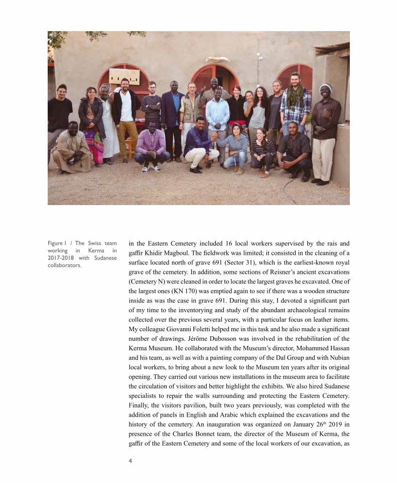
The complete Swiss team arrived in Khartoum on December 28th 2017 and began its work in Kerma on December 30th. Supervised by Matthieu Honegger, it comprised 7 students from the Universities of Neuchâtel and Fribourg (Benjamin Auberson, Aurelia Basterrecha, Théophile Burnat, Medea Loputesa, Francesca Salvini, Nathanael Sordat and Lauriane Vieli), a Doctor (Jérôme Dubosson) who took charge of the work of maintenance and rehabilitation, supported by the QSAP, a photographer (Marc Juillard), an ancient leather and textile specialist (Jacques Reinhard), two PhD candidates working on pottery (Chrystel Jeanbourquin and Marie-Kristin Schröder) and a bioanthropologist working on the human skeletons (Agathe Chen). The team worked on the excavation of the 28 graves cleared during the first part of the season and studied a part of the material found during the previous season (figure 1). During January, we were visited by the Swiss Ambassador, Daniel Cavegn, whom we would like to thank here for his generosity and support.
The 2018-2019 season was restricted in its scope. The fieldwork started on January 2nd and was completed on January 31st, 2019. On this occasion no large-scale excavations were conducted and no students accompanied us. The team working
Matthieu Honegger
4
in the Eastern Cemetery included 16 local workers supervised by the rais and gaffir Khidir Magboul. The fieldwork was limited; it consisted in the cleaning of a surface located north of grave 691 (Sector 31), which is the earliest-known royal grave of the cemetery. In addition, some sections of Reisner’s ancient excavations (Cemetery N) were cleaned in order to locate the largest graves he excavated. One of the largest ones (KN 170) was emptied again to see if there was a wooden structure inside as was the case in grave 691. During this stay, I devoted a significant part of my time to the inventorying and study of the abundant archaeological remains collected over the previous several years, with a particular focus on leather items. My colleague Giovanni Foletti helped me in this task and he also made a significant number of drawings. Jérôme Dubosson was involved in the rehabilitation of the Kerma Museum. He collaborated with the Museum’s director, Mohammed Hassan and his team, as well as with a painting company of the Dal Group and with Nubian local workers, to bring about a new look to the Museum ten years after its original opening. They carried out various new installations in the museum area to facilitate the circulation of visitors and better highlight the exhibits. We also hired Sudanese specialists to repair the walls surrounding and protecting the Eastern Cemetery. Finally, the visitors pavilion, built two years previously, was completed with the addition of panels in English and Arabic which explained the excavations and the history of the cemetery. An inauguration was organized on January 26th 2019 in presence of the Charles Bonnet team, the director of the Museum of Kerma, the gaffir of the Eastern Cemetery and some of the local workers of our excavation, as
Figure 1 / The Swiss team working in Kerma in 2017-2018 with Sudanese collaborators.
5
well as the team leaders working on the rehabilitation of the Museum of Kerma. Two professors in prehistory joined the Swiss Mission from the 24th to the 31st of January in order to inspect some Middle Stone Age sites in our concession (Prof. Nuno Bicho of the University of Algarve in Portugal and Prof. Jonathan Haws of the University of Louisville, USA). In future years, we plan to organize new excavations of these sites in collaboration with them.
The Swiss Mission is supported by Dr Abdelrahman Ali, director of the National Corporation of Antiquities and Museums of Sudan (NCAM) and his collaborator, Mr El-Hassan Ahmed Mohamed. Shahinda Omer of the NCAM was the inspector of the mission during the two seasons, and followed our fieldwork. The project is supported by the Swiss National Fund (SNF 100011_163021/1), the State Secretariat for Education, Research and Innovation of the Swiss Confederation, the Kerma Foundation and the University of Neuchâtel (Switzerland). Until June 2019, we have benefitted from the support of the Qatar Sudan Archaeological Project for its protection and valorisation. For the project on Middle Stone Age in collaboration with the Universities of Algarve and Louisville (see paper of Bicho et al, this volume), the Fundação para a Ciência e Tecnologia (ICArEHB - UID/ARQ/04211/2013) contributed to the financing of the first season.
6
THE EASTERN CEMETERY OF KERMA AND ITS FIRST ROYAL GRAVES
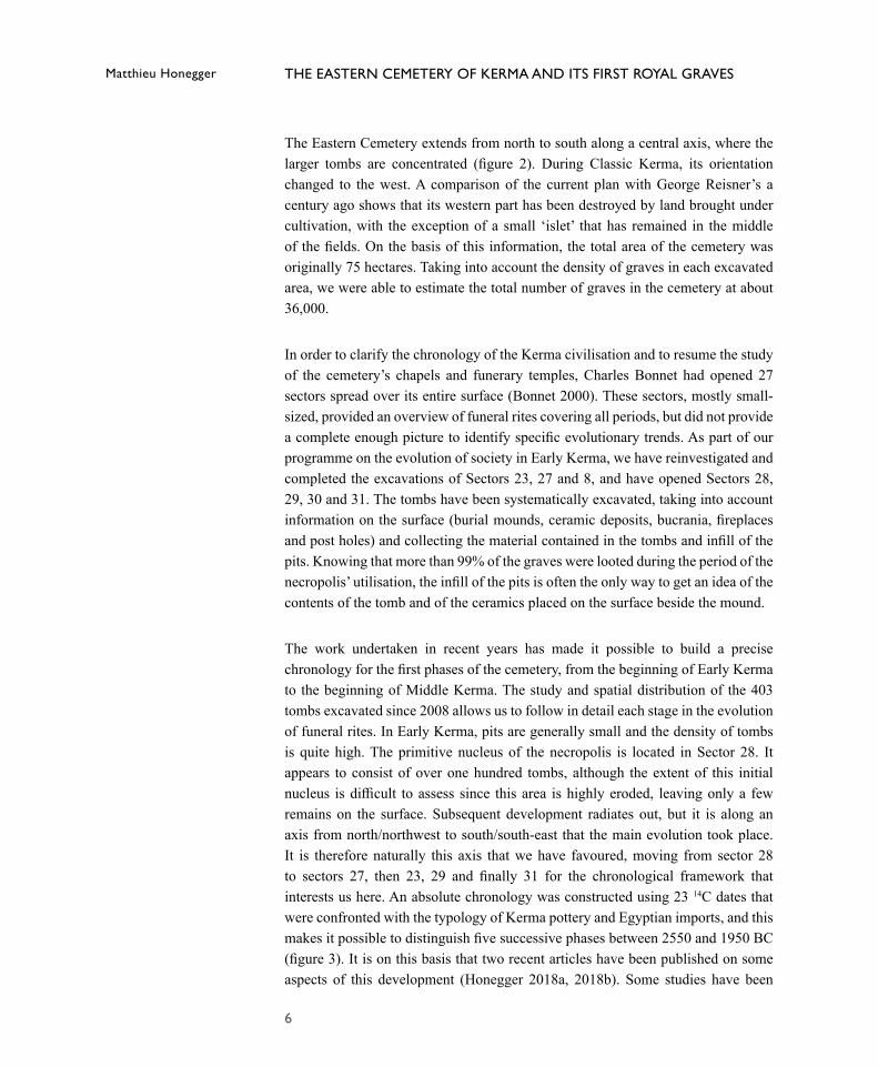
The Eastern Cemetery extends from north to south along a central axis, where the larger tombs are concentrated (figure 2). During Classic Kerma, its orientation changed to the west. A comparison of the current plan with George Reisner’s a century ago shows that its western part has been destroyed by land brought under cultivation, with the exception of a small ‘islet’ that has remained in the middle of the fields. On the basis of this information, the total area of the cemetery was originally 75 hectares. Taking into account the density of graves in each excavated area, we were able to estimate the total number of graves in the cemetery at about 36,000.
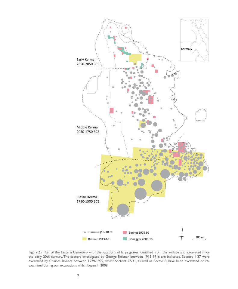
In order to clarify the chronology of the Kerma civilisation and to resume the study of the cemetery’s chapels and funerary temples, Charles Bonnet had opened 27 sectors spread over its entire surface (Bonnet 2000). These sectors, mostly small-sized, provided an overview of funeral rites covering all periods, but did not provide a complete enough picture to identify specific evolutionary trends. As part of our programme on the evolution of society in Early Kerma, we have reinvestigated and completed the excavations of Sectors 23, 27 and 8, and have opened Sectors 28, 29, 30 and 31. The tombs have been systematically excavated, taking into account information on the surface (burial mounds, ceramic deposits, bucrania, fireplaces and post holes) and collecting the material contained in the tombs and infill of the pits. Knowing that more than 99% of the graves were looted during the period of the necropolis’ utilisation, the infill of the pits is often the only way to get an idea of the contents of the tomb and of the ceramics placed on the surface beside the mound.
The work undertaken in recent years has made it possible to build a precise chronology for the first phases of the cemetery, from the beginning of Early Kerma to the beginning of Middle Kerma. The study and spatial distribution of the 403 tombs excavated since 2008 allows us to follow in detail each stage in the evolution of funeral rites. In Early Kerma, pits are generally small and the density of tombs is quite high. The primitive nucleus of the necropolis is located in Sector 28. It appears to consist of over one hundred tombs, although the extent of this initial nucleus is difficult to assess since this area is highly eroded, leaving only a few remains on the surface. Subsequent development radiates out, but it is along an axis from north/northwest to south/south-east that the main evolution took place. It is therefore naturally this axis that we have favoured, moving from sector 28 to sectors 27, then 23, 29 and finally 31 for the chronological framework that interests us here. An absolute chronology was constructed using 23 14C dates that were confronted with the typology of Kerma pottery and Egyptian imports, and this makes it possible to distinguish five successive phases between 2550 and 1950 BC (figure 3). It is on this basis that two recent articles have been published on some aspects of this development (Honegger 2018a, 2018b). Some studies have been
Matthieu Honegger
7
Figure 2 / Plan of the Eastern Cemetery with the locations of large graves identified from the surface and excavated since the early 20th century. The sectors investigated by George Reisner between 1913-1916 are indicated. Sectors 1-27 were excavated by Charles Bonnet between 1979-1999, whilst Sectors 27-31, as well as Sector 8, have been excavated or re-examined during our excavations which began in 2008.
tumulus Ø > 10 m
Kerma
Early Kerma2550-2050 BCE
Middle Kerma 2050-1750 BCE
Classic Kerma1750-1500 BCE
100 mReisner 1913-16
Bonnet 1979-99
Honegger 2008-18
8
Figure 3 / Detailed plan of the Early Kerma sectors showing their chronology based on the radiocarbon dates.
50 m
Graves excavated by:
Bonnet 1980-1997Honegger 2008-2018
Cime�ère NReisner 1915-1916
CE 23
CE 29
CE 27
CE 8
CE 28
CE 6
CE 7
CE 26
CE 4
CE30
CE1
CE 3
CE 2
CE 5
Kerma ancien 02550-2450 BC Kerma ancien I
2450-2300 BC
Kerma ancien II2300-2150 BC
Kerma ancien II2300-2150 BC
CE 31
Kerma ancien III2150-2050 BC
Kerma moyen I2050-1950 BC
Small gravesFew social distinction
Herkouf expeditionsRicher gravesStronger social distinctions
Trade with the Egyptiansat the 2nd cataractFirst royal graves
9
completed for publication as monographs, namely the study of Group C pottery and Egyptian imports (Marie-Kristin Schröder) and the study on skeletal anthropology (Agathe Chen). Studies on the other aspects are well advanced, but the richness of the documentation still requires work to go beyond a simple description in catalogue form.
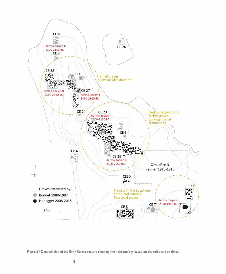
Thanks to the last two excavation campaigns, this general evolution has been completed by completing the excavation of Sector 29 (Kerma ancien III) and by studying Sector 31 (Kerma moyen I), which makes it possible to identify the transition that marks the emergence of the first royal tombs. In Sector 29, the last eleven graves were excavated over a surface of 300 square metres (figure 4). They had all been plundered and revealed, as was the case during the previous seasons, male graves accompanied by a bow and sometimes by sheep, and female graves accompanied by a stick. On the eastern edge of this sector, two graves with a sandy infill probably correspond to graves excavated by Reisner in the area called ‘Cemetery N’. Sector 31 is located on the south-eastern fringe of this ‘Cemetery N’, which was published by Dunham in 1982 (Dunham, 1982). It contains the catalogue of the 170 excavated graves without any comment. In 1915, when Reisner started working in this sector, he carefully studied 35 graves, which he located precisely. In 1916, Reisner left Kerma for Karima and left his assistant, W. G. Kemp, working alone on 135 further graves. W. G. Kemp made a description and a drawing of each
Figure 4 / Plan of the eastern part of Sector 29 excavated during the 2017-2018 campaign.
970N
965N
960N
955N
160W
155W
150W
145W
140W
135W
Kerma 2017-2018 CE29 east 5mPottery Bucrania
N644
656
667668
669670
671
672
673 674
675
676
677
678
679
680
681
682
695
graves excavated by Reisner 100 years ago
10
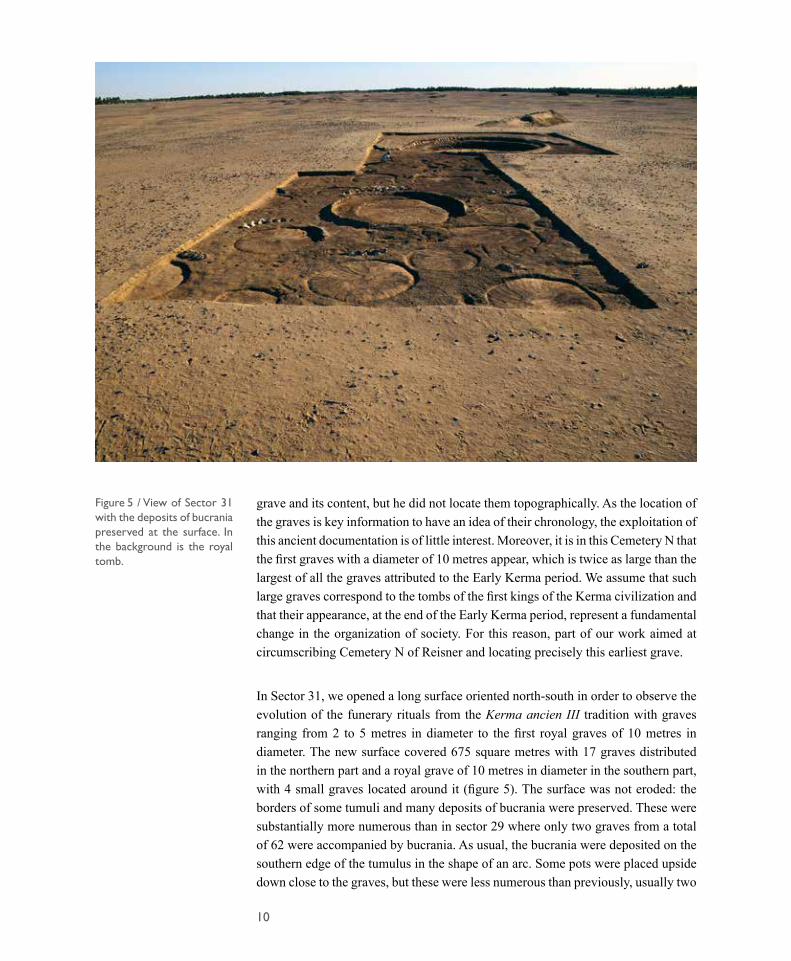
Figure 5 / View of Sector 31 with the deposits of bucrania preserved at the surface. In the background is the royal tomb.
grave and its content, but he did not locate them topographically. As the location of the graves is key information to have an idea of their chronology, the exploitation of this ancient documentation is of little interest. Moreover, it is in this Cemetery N that the first graves with a diameter of 10 metres appear, which is twice as large than the largest of all the graves attributed to the Early Kerma period. We assume that such large graves correspond to the tombs of the first kings of the Kerma civilization and that their appearance, at the end of the Early Kerma period, represent a fundamental change in the organization of society. For this reason, part of our work aimed at circumscribing Cemetery N of Reisner and locating precisely this earliest grave.
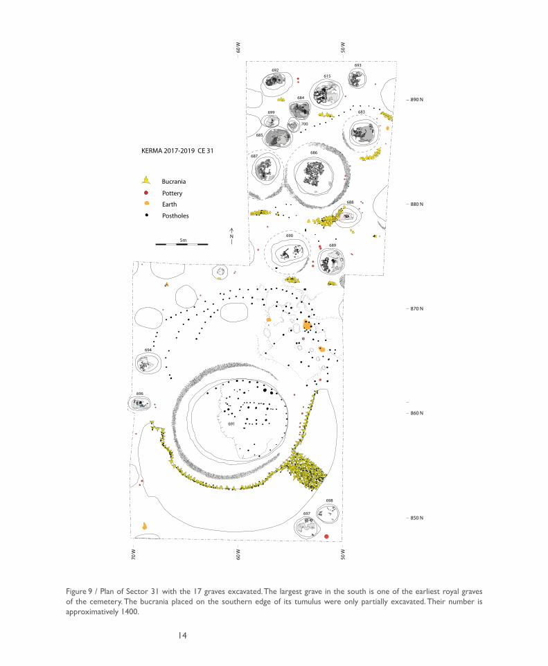
In Sector 31, we opened a long surface oriented north-south in order to observe the evolution of the funerary rituals from the Kerma ancien III tradition with graves ranging from 2 to 5 metres in diameter to the first royal graves of 10 metres in diameter. The new surface covered 675 square metres with 17 graves distributed in the northern part and a royal grave of 10 metres in diameter in the southern part, with 4 small graves located around it (figure 5). The surface was not eroded: the borders of some tumuli and many deposits of bucrania were preserved. These were substantially more numerous than in sector 29 where only two graves from a total of 62 were accompanied by bucrania. As usual, the bucrania were deposited on the southern edge of the tumulus in the shape of an arc. Some pots were placed upside down close to the graves, but these were less numerous than previously, usually two
11
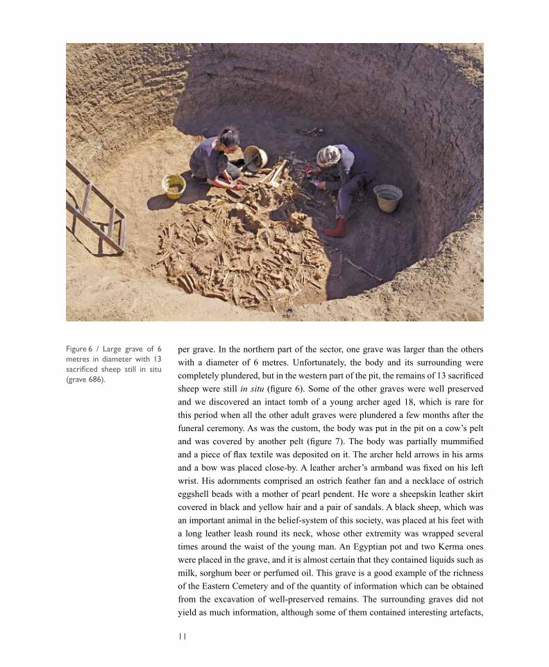
Figure 6 / Large grave of 6 metres in diameter with 13 sacrificed sheep still in situ (grave 686).
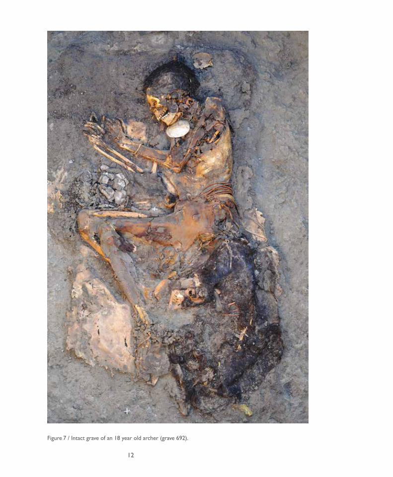
per grave. In the northern part of the sector, one grave was larger than the others with a diameter of 6 metres. Unfortunately, the body and its surrounding were completely plundered, but in the western part of the pit, the remains of 13 sacrificed sheep were still in situ (figure 6). Some of the other graves were well preserved and we discovered an intact tomb of a young archer aged 18, which is rare for this period when all the other adult graves were plundered a few months after the funeral ceremony. As was the custom, the body was put in the pit on a cow’s pelt and was covered by another pelt (figure 7). The body was partially mummified and a piece of flax textile was deposited on it. The archer held arrows in his arms and a bow was placed close-by. A leather archer’s armband was fixed on his left wrist. His adornments comprised an ostrich feather fan and a necklace of ostrich eggshell beads with a mother of pearl pendent. He wore a sheepskin leather skirt covered in black and yellow hair and a pair of sandals. A black sheep, which was an important animal in the belief-system of this society, was placed at his feet with a long leather leash round its neck, whose other extremity was wrapped several times around the waist of the young man. An Egyptian pot and two Kerma ones were placed in the grave, and it is almost certain that they contained liquids such as milk, sorghum beer or perfumed oil. This grave is a good example of the richness of the Eastern Cemetery and of the quantity of information which can be obtained from the excavation of well-preserved remains. The surrounding graves did not yield as much information, although some of them contained interesting artefacts,
12
Figure 7 / Intact grave of an 18 year old archer (grave 692).
13
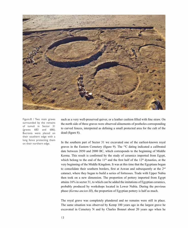
such as a very well-preserved quiver, or a leather cushion filled with fine straw. On the north side of three graves were observed alinements of postholes corresponding to curved fences, interpreted as defining a small protected area for the cult of the dead (figure 8).
In the southern part of Sector 31 we excavated one of the earliest-known royal graves in the Eastern Cemetery (figure 9). The 14C dating indicated a calibrated date between 2050 and 2000 BC, which corresponds to the beginning of Middle Kerma. This result is confirmed by the study of ceramics imported from Egypt, which belong to the end of the 11th and the first half of the 12th dynasties, at the very beginning of the Middle Kingdom. It was at this time that the Egyptians began to consolidate their southern borders, first at Aswan and subsequently at the 2nd cataract, where they began to build a series of fortresses. Trade with Upper Nubia then took on a new dimension. The proportion of pottery imported from Egypt attains 16% in sector 31, to which can be added the imitations of Egyptian ceramics, probably produced by workshops located in Lower Nubia. During the previous phase (Kerma ancien III), the proportion of Egyptian pottery is half as much.
The royal grave was completely plundered and no remains were still in place. The same situation was observed by Kemp 100 years ago in the largest grave he excavated in Cemetery N and by Charles Bonnet about 20 years ago when he
Figure 8 / Two main graves surrounded by the remains of tumuli in Sector 31 (graves 683 and 686). Bucrania were placed on their southern edge with a long fence protecting them on their northern edge.
14
Figure 9 / Plan of Sector 31 with the 17 graves excavated. The largest grave in the south is one of the earliest royal graves of the cemetery. The bucrania placed on the southern edge of its tumulus were only partially excavated. Their number is approximatively 1400.
KERMA 2017-2019 CE 31
Pottery
Bucrania
N5m
70 W
60 W
50 W
60 W
50 W
870 N
860 N
850 N
880 N
890 N
Postholes
Earth
700
699
698
697
696
694
693692
691
690
689
688
687686
685
684
683
615
15
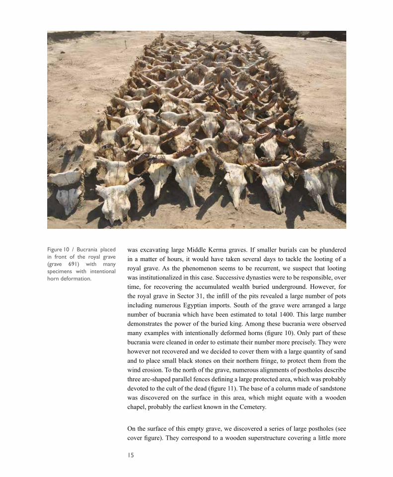
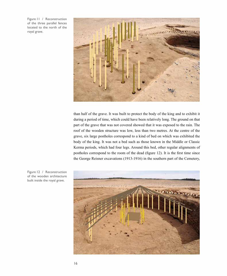
was excavating large Middle Kerma graves. If smaller burials can be plundered in a matter of hours, it would have taken several days to tackle the looting of a royal grave. As the phenomenon seems to be recurrent, we suspect that looting was institutionalized in this case. Successive dynasties were to be responsible, over time, for recovering the accumulated wealth buried underground. However, for the royal grave in Sector 31, the infill of the pits revealed a large number of pots including numerous Egyptian imports. South of the grave were arranged a large number of bucrania which have been estimated to total 1400. This large number demonstrates the power of the buried king. Among these bucrania were observed many examples with intentionally deformed horns (figure 10). Only part of these bucrania were cleaned in order to estimate their number more precisely. They were however not recovered and we decided to cover them with a large quantity of sand and to place small black stones on their northern fringe, to protect them from the wind erosion. To the north of the grave, numerous alignments of postholes describe three arc-shaped parallel fences defining a large protected area, which was probably devoted to the cult of the dead (figure 11). The base of a column made of sandstone was discovered on the surface in this area, which might equate with a wooden chapel, probably the earliest known in the Cemetery.
On the surface of this empty grave, we discovered a series of large postholes (see cover figure). They correspond to a wooden superstructure covering a little more
Figure 10 / Bucrania placed in front of the royal grave (grave 691) with many specimens with intentional horn deformation.
16
than half of the grave. It was built to protect the body of the king and to exhibit it during a period of time, which could have been relatively long. The ground on that part of the grave that was not covered showed that it was exposed to the rain. The roof of the wooden structure was low, less than two metres. At the centre of the grave, six large postholes correspond to a kind of bed on which was exhibited the body of the king. It was not a bed such as those known in the Middle or Classic Kerma periods, which had four legs. Around this bed, other regular alignments of postholes correspond to the room of the dead (figure 12). It is the first time since the George Reisner excavations (1913-1916) in the southern part of the Cemetery,
Figure 12 / Reconstruction of the wooden architecture built inside the royal grave.
Figure 11 / Reconstruction of the three parallel fences located to the north of the royal grave.
17
dating from the Classic Kerma period (1750-1500 BC), that upright structures have been observed inside a grave. This discovery reveals much information on the royal funerary traditions, as well as revealing architecture poorly studied previously. This architecture, made of wood and earth, was the only method of constructing domestic and monumental buildings prior to the adoption of mud brick, which appears at the beginning of Middle Kerma. With the exception of the Pre-Kerma town excavated many years ago and some wooden structures found in the town of Kerma, we know almost nothing about this architecture, which was the dominant way of building in a large part of Africa before the adoption of the brick.
It must therefore be assumed that this tomb remained open for several weeks or even months. A semi-circular hut, open to the west, was built to shelter and expose the deceased. The king’s clients from all parts of the kingdom had to come to pray and offer herds of cows. The meat would have been eaten during banquets, after which the heads were placed on the ground, south of the tomb. After a time, the tomb was closed, filled and then surmounted by the mound. North of the tomb,
KERMA 2017-2018Sector 31 Grave 691
N
10 metres
Bucrania
Tumulus
Fences
Chapel
Entranceof thefuneraryComplex
Basis of column
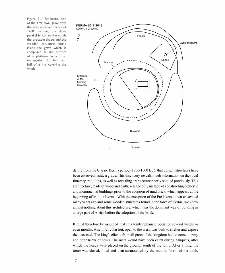
Figure 13 / Schematic plan of the first royal grave with the area occupied by about 1400 bucrania, the three parallel fences to the north, the probable chapel and the wooden structure found inside the grave which is composed at the bottom of a platform in a small rectangular chamber and half of a hut covering the whole.
18
three arched palisades were built to join the arrangement of the bucrania, forming a funerary enclosure around the tomb. A chapel was erected against the fences, comprising a stone column base and a fireplace at its northern end. The enclosure was to be used for the cult of the deceased, as would be the rule for later royal tombs (Figure 13). While it has long been thought that royalty appeared only in Classic Kerma, following the spectacular results of excavations at the beginning of the 20th century, our discovery shows that royalty was established several centuries earlier and that Kerma was established as the capital from the beginning of Middle Kerma.
The contrast between this funerary complex and the earlier tombs is so marked that the term royal does not seem to be exaggerated. Faced with an increasingly lucrative trade with Egypt, a lineage had to succeed in imposing itself over others, by force of arms, in order to control the benefits resulting from trade with the Egyptians. Such a scenario must not only have occurred in the Kerma region, but throughout Upper Nubia, where it was probably necessary to dominate rival tribes and establish a system of alliances with the populations further south, through whom part of the sought-after goods were obtained. In the same vein, the heads of cattle in front of the tomb do not originate from a single herd, but probably result from marks of deference from the king’s clients, who came to renew their loyalty to the deceased with a final offering.
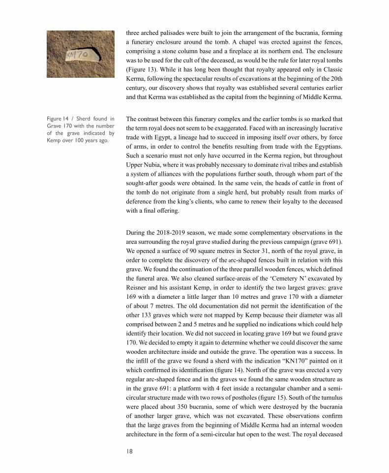
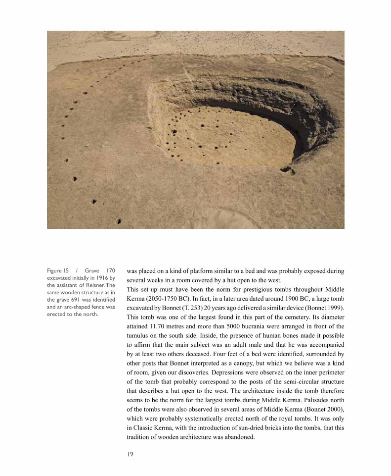
During the 2018-2019 season, we made some complementary observations in the area surrounding the royal grave studied during the previous campaign (grave 691). We opened a surface of 90 square metres in Sector 31, north of the royal grave, in order to complete the discovery of the arc-shaped fences built in relation with this grave. We found the continuation of the three parallel wooden fences, which defined the funeral area. We also cleaned surface-areas of the ‘Cemetery N’ excavated by Reisner and his assistant Kemp, in order to identify the two largest graves: grave 169 with a diameter a little larger than 10 metres and grave 170 with a diameter of about 7 metres. The old documentation did not permit the identification of the other 133 graves which were not mapped by Kemp because their diameter was all comprised between 2 and 5 metres and he supplied no indications which could help identify their location. We did not succeed in locating grave 169 but we found grave 170. We decided to empty it again to determine whether we could discover the same wooden architecture inside and outside the grave. The operation was a success. In the infill of the grave we found a sherd with the indication “KN170” painted on it which confirmed its identification (figure 14). North of the grave was erected a very regular arc-shaped fence and in the graves we found the same wooden structure as in the grave 691: a platform with 4 feet inside a rectangular chamber and a semi-circular structure made with two rows of postholes (figure 15). South of the tumulus were placed about 350 bucrania, some of which were destroyed by the bucrania of another larger grave, which was not excavated. These observations confirm that the large graves from the beginning of Middle Kerma had an internal wooden architecture in the form of a semi-circular hut open to the west. The royal deceased
Figure 14 / Sherd found in Grave 170 with the number of the grave indicated by Kemp over 100 years ago.
19
was placed on a kind of platform similar to a bed and was probably exposed during several weeks in a room covered by a hut open to the west. This set-up must have been the norm for prestigious tombs throughout Middle Kerma (2050-1750 BC). In fact, in a later area dated around 1900 BC, a large tomb excavated by Bonnet (T. 253) 20 years ago delivered a similar device (Bonnet 1999). This tomb was one of the largest found in this part of the cemetery. Its diameter attained 11.70 metres and more than 5000 bucrania were arranged in front of the tumulus on the south side. Inside, the presence of human bones made it possible to affirm that the main subject was an adult male and that he was accompanied by at least two others deceased. Four feet of a bed were identified, surrounded by other posts that Bonnet interpreted as a canopy, but which we believe was a kind of room, given our discoveries. Depressions were observed on the inner perimeter of the tomb that probably correspond to the posts of the semi-circular structure that describes a hut open to the west. The architecture inside the tomb therefore seems to be the norm for the largest tombs during Middle Kerma. Palisades north of the tombs were also observed in several areas of Middle Kerma (Bonnet 2000), which were probably systematically erected north of the royal tombs. It was only in Classic Kerma, with the introduction of sun-dried bricks into the tombs, that this tradition of wooden architecture was abandoned.
Figure 15 / Grave 170 excavated initially in 1916 by the assistant of Reisner. The same wooden structure as in the grave 691 was identified and an arc-shaped fence was erected to the north.
20
FIRST RESULTS OF A MIDDLE STONE AGE SURVEY IN THE KERMA REGION, NORTHERN SUDAN
One of the primary centres for understanding the process of Anatomically Modern Human dispersal and migration is the Nile Valley and the coastal region of the Red Sea, including Sudan, Egypt, and Ethiopia (Goder-Goldberger 2014, Rose et al. 2011). Nubian technology has been used as the tracer for the transit from Africa to the Arabian Peninsula (Van Peer 1998), sometime between 150 and 60 thousand years ago. Middle Stone Age sites are relatively rare in Sudan, except for the work carried out in the Sudanese-Egyptian border by Marks in the 1960’s (e.g. Marks 1968) and a couple of decades later by Van Peer (Van Peer 1998, Van Peer et al. 2003). Recently, Sudan has also been the focus of attention both on the coast, by Beyin’s team (Beyin et al. 2019a, Beyin et al. 2019b), and in the Nile Valley, near the 4th Cataract, by Olszewski and the University of Pennsylvania Team (Olszewski et al. 2019).
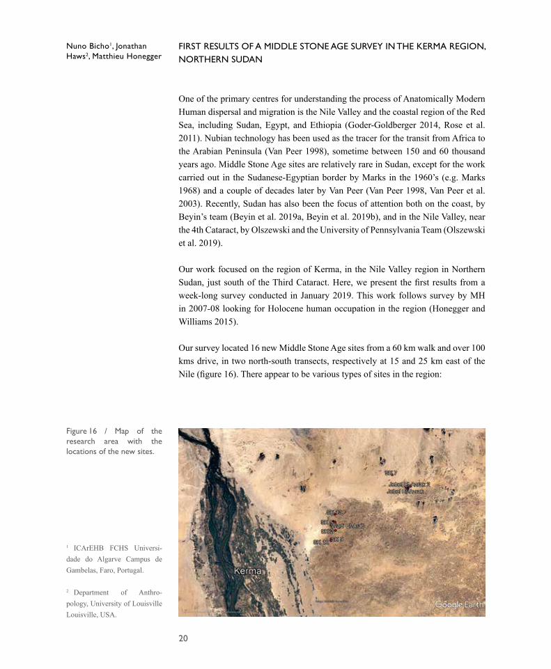
Our work focused on the region of Kerma, in the Nile Valley region in Northern Sudan, just south of the Third Cataract. Here, we present the first results from a week-long survey conducted in January 2019. This work follows survey by MH in 2007-08 looking for Holocene human occupation in the region (Honegger and Williams 2015).
Our survey located 16 new Middle Stone Age sites from a 60 km walk and over 100 kms drive, in two north-south transects, respectively at 15 and 25 km east of the Nile (figure 16). There appear to be various types of sites in the region:
Nuno Bicho1, Jonathan Haws2, Matthieu Honegger
1 ICArEHB FCHS Universi-dade do Algarve Campus de Gambelas, Faro, Portugal.
2 Department of Anthro-pology, University of Louisville Louisville, USA.
Figure 16 / Map of the research area with the locations of the new sites.
21
• The most common location is on the flat stone pavement desert directly associated with a hilly basalt outcrop, no more than 15 to 20 metres high, visible on the landscape from a distance of several km. These are surface sites.
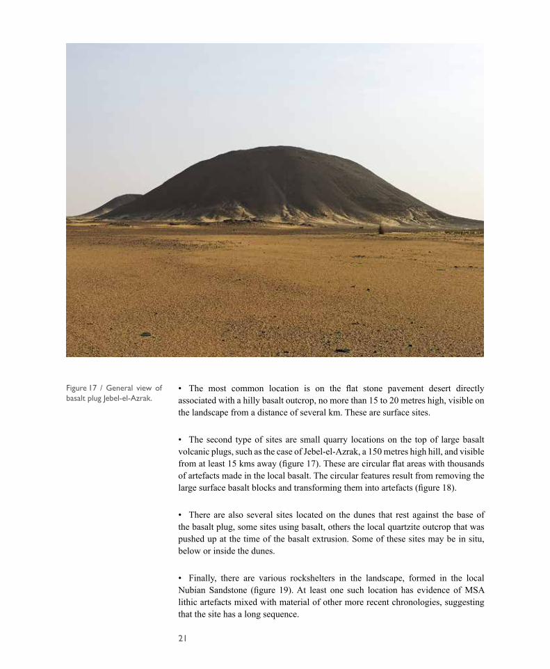
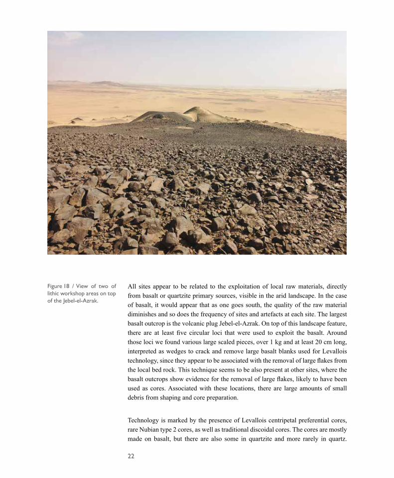
• The second type of sites are small quarry locations on the top of large basalt volcanic plugs, such as the case of Jebel-el-Azrak, a 150 metres high hill, and visible from at least 15 kms away (figure 17). These are circular flat areas with thousands of artefacts made in the local basalt. The circular features result from removing the large surface basalt blocks and transforming them into artefacts (figure 18).
• There are also several sites located on the dunes that rest against the base of the basalt plug, some sites using basalt, others the local quartzite outcrop that was pushed up at the time of the basalt extrusion. Some of these sites may be in situ, below or inside the dunes.
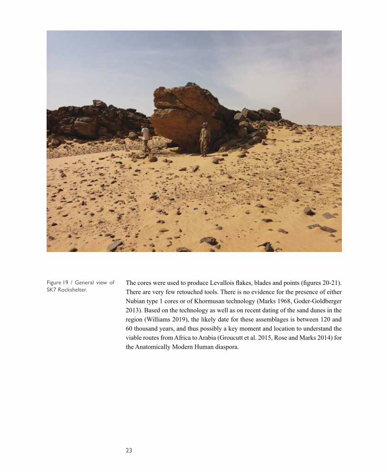
• Finally, there are various rockshelters in the landscape, formed in the local Nubian Sandstone (figure 19). At least one such location has evidence of MSA lithic artefacts mixed with material of other more recent chronologies, suggesting that the site has a long sequence.
Figure 17 / General view of basalt plug Jebel-el-Azrak.
22
All sites appear to be related to the exploitation of local raw materials, directly from basalt or quartzite primary sources, visible in the arid landscape. In the case of basalt, it would appear that as one goes south, the quality of the raw material diminishes and so does the frequency of sites and artefacts at each site. The largest basalt outcrop is the volcanic plug Jebel-el-Azrak. On top of this landscape feature, there are at least five circular loci that were used to exploit the basalt. Around those loci we found various large scaled pieces, over 1 kg and at least 20 cm long, interpreted as wedges to crack and remove large basalt blanks used for Levallois technology, since they appear to be associated with the removal of large flakes from the local bed rock. This technique seems to be also present at other sites, where the basalt outcrops show evidence for the removal of large flakes, likely to have been used as cores. Associated with these locations, there are large amounts of small debris from shaping and core preparation.
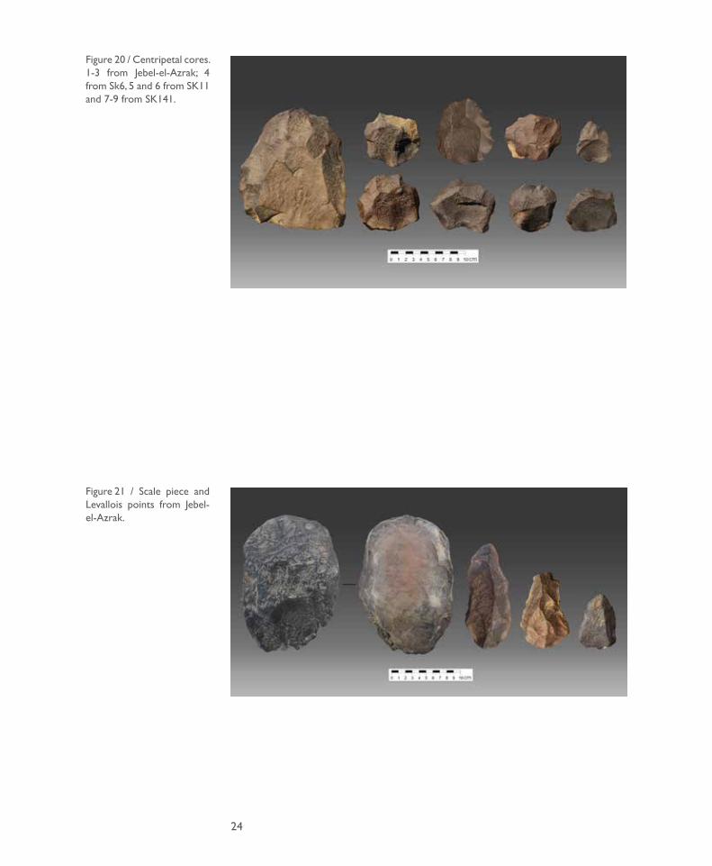
Technology is marked by the presence of Levallois centripetal preferential cores, rare Nubian type 2 cores, as well as traditional discoidal cores. The cores are mostly made on basalt, but there are also some in quartzite and more rarely in quartz.
Figure 18 / View of two of lithic workshop areas on top of the Jebel-el-Azrak.
23
The cores were used to produce Levallois flakes, blades and points (figures 20-21). There are very few retouched tools. There is no evidence for the presence of either Nubian type 1 cores or of Khormusan technology (Marks 1968, Goder-Goldberger 2013). Based on the technology as well as on recent dating of the sand dunes in the region (Williams 2019), the likely date for these assemblages is between 120 and 60 thousand years, and thus possibly a key moment and location to understand the viable routes from Africa to Arabia (Groucutt et al. 2015, Rose and Marks 2014) for the Anatomically Modern Human diaspora.
Figure 19 / General view of SK7 Rockshelter.
24
Figure 20 / Centripetal cores. 1-3 from Jebel-el-Azrak; 4 from Sk6, 5 and 6 from SK11 and 7-9 from SK141.
Figure 21 / Scale piece and Levallois points from Jebel-el-Azrak.
25
MUSEUM REHABILITATION AND VALORISATION OF THE EASTERN CEMETERY
Museum rehabilitation
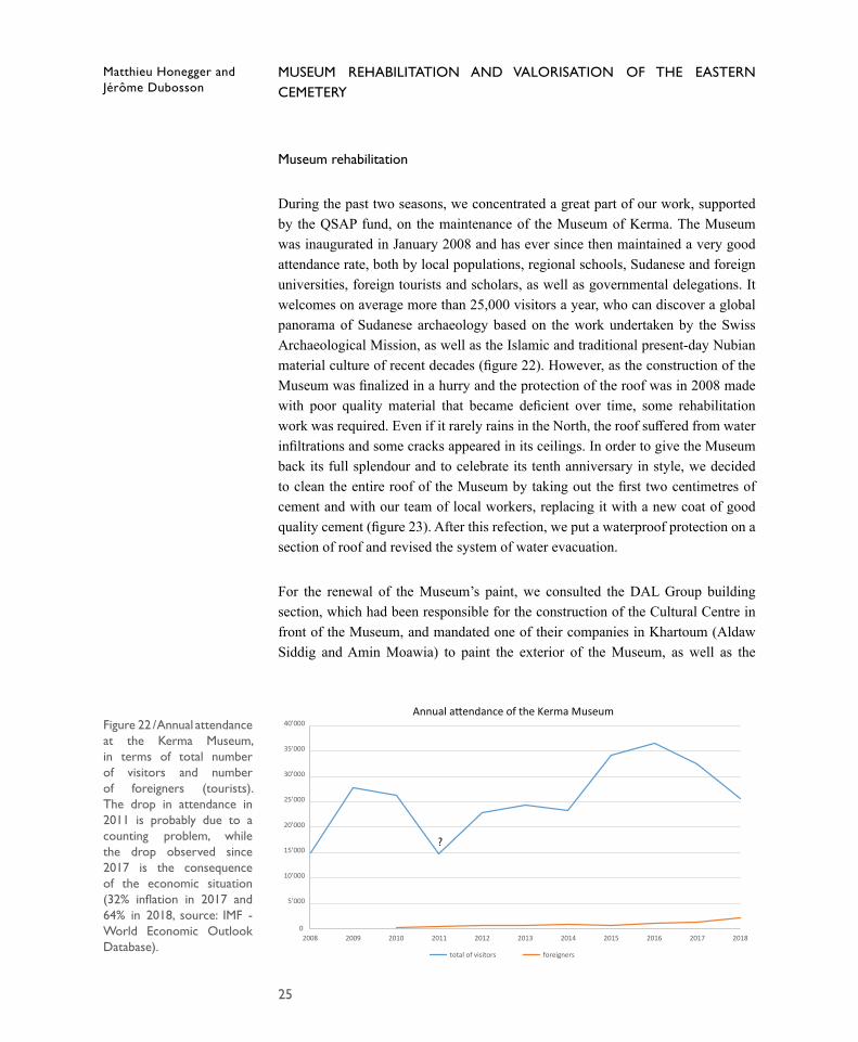
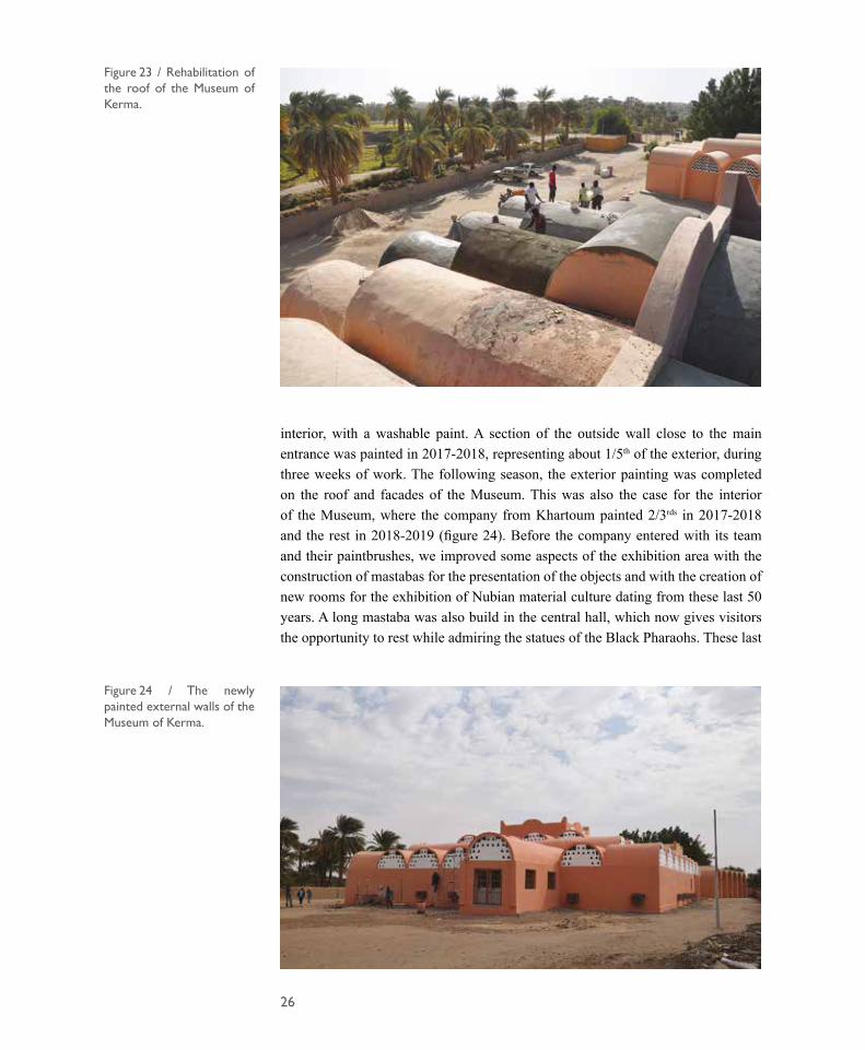
During the past two seasons, we concentrated a great part of our work, supported by the QSAP fund, on the maintenance of the Museum of Kerma. The Museum was inaugurated in January 2008 and has ever since then maintained a very good attendance rate, both by local populations, regional schools, Sudanese and foreign universities, foreign tourists and scholars, as well as governmental delegations. It welcomes on average more than 25,000 visitors a year, who can discover a global panorama of Sudanese archaeology based on the work undertaken by the Swiss Archaeological Mission, as well as the Islamic and traditional present-day Nubian material culture of recent decades (figure 22). However, as the construction of the Museum was finalized in a hurry and the protection of the roof was in 2008 made with poor quality material that became deficient over time, some rehabilitation work was required. Even if it rarely rains in the North, the roof suffered from water infiltrations and some cracks appeared in its ceilings. In order to give the Museum back its full splendour and to celebrate its tenth anniversary in style, we decided to clean the entire roof of the Museum by taking out the first two centimetres of cement and with our team of local workers, replacing it with a new coat of good quality cement (figure 23). After this refection, we put a waterproof protection on a section of roof and revised the system of water evacuation.
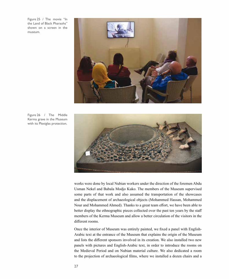
For the renewal of the Museum’s paint, we consulted the DAL Group building section, which had been responsible for the construction of the Cultural Centre in front of the Museum, and mandated one of their companies in Khartoum (Aldaw Siddig and Amin Moawia) to paint the exterior of the Museum, as well as the
Matthieu Honegger and Jérôme Dubosson
0
5’000
10’000
15’000
20’000
25’000
30’000
35’000
40’000
2008 2009 2010 2011 2012 2013 2014 2015 2016 2017 2018
Annual a�endance of the Kerma Museum
total of visitors foreigners
?
Figure 22 / Annual attendance at the Kerma Museum, in terms of total number of visitors and number of foreigners (tourists). The drop in attendance in 2011 is probably due to a counting problem, while the drop observed since 2017 is the consequence of the economic situation (32% inflation in 2017 and 64% in 2018, source: IMF - World Economic Outlook Database).
26
Figure 23 / Rehabilitation of the roof of the Museum of Kerma.
Figure 24 / The newly painted external walls of the Museum of Kerma.
interior, with a washable paint. A section of the outside wall close to the main entrance was painted in 2017-2018, representing about 1/5th of the exterior, during three weeks of work. The following season, the exterior painting was completed on the roof and facades of the Museum. This was also the case for the interior of the Museum, where the company from Khartoum painted 2/3rds in 2017-2018 and the rest in 2018-2019 (figure 24). Before the company entered with its team and their paintbrushes, we improved some aspects of the exhibition area with the construction of mastabas for the presentation of the objects and with the creation of new rooms for the exhibition of Nubian material culture dating from these last 50 years. A long mastaba was also build in the central hall, which now gives visitors the opportunity to rest while admiring the statues of the Black Pharaohs. These last
27
works were done by local Nubian workers under the direction of the foremen Abdu Usman Nekel and Babala Modjo Kuko. The members of the Museum supervised some parts of that work and also assumed the transportation of the showcases and the displacement of archaeological objects (Mohammed Hassan, Mohammed Nour and Mohammed Ahmed). Thanks to a great team effort, we have been able to better display the ethnographic pieces collected over the past ten years by the staff members of the Kerma Museum and allow a better circulation of the visitors in the different rooms.
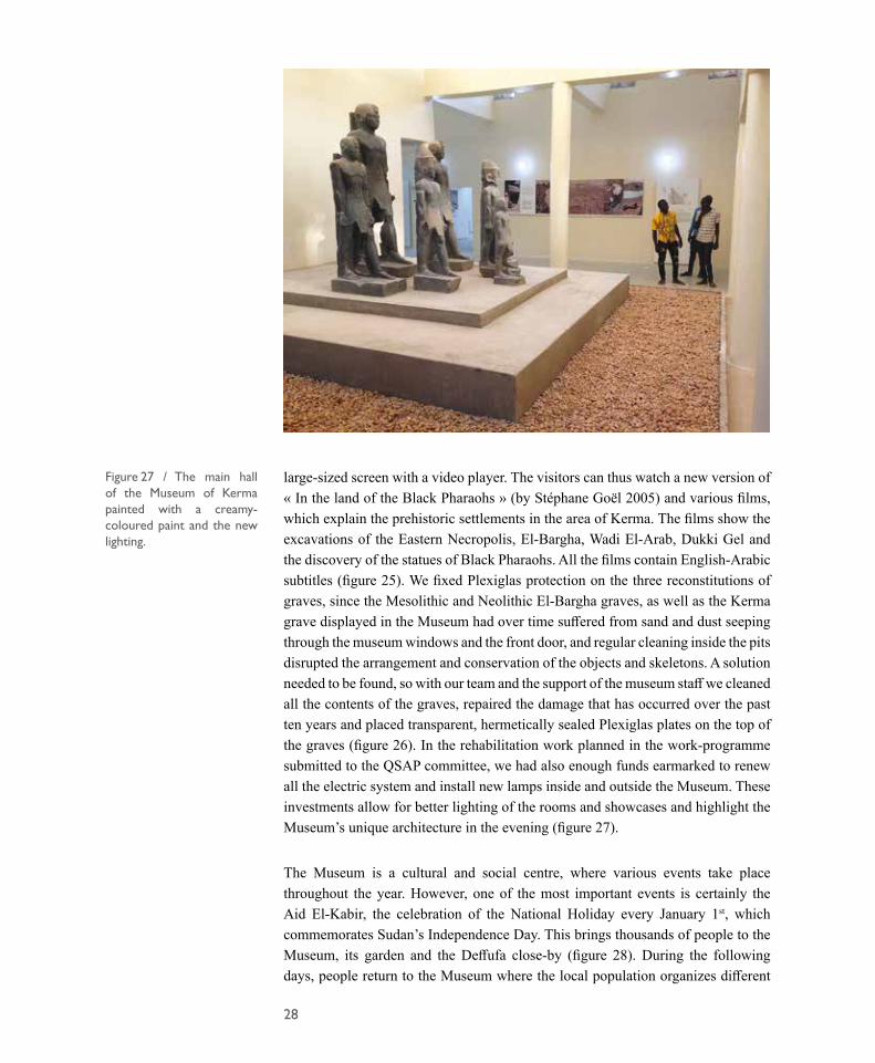
Once the interior of Museum was entirely painted, we fixed a panel with English-Arabic text at the entrance of the Museum that explains the origin of the Museum and lists the different sponsors involved in its creation. We also installed two new panels with pictures and English-Arabic text, in order to introduce the rooms on the Medieval Period and on Nubian material culture. We also dedicated a room to the projection of archaeological films, where we installed a dozen chairs and a
Figure 25 / The movie “In the Land of Black Pharaohs” shown on a screen in the museum.
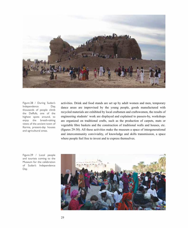
Figure 26 / The Middle Kerma grave in the Museum with its Plexiglas protection.
28
large-sized screen with a video player. The visitors can thus watch a new version of « In the land of the Black Pharaohs » (by Stéphane Goël 2005) and various films, which explain the prehistoric settlements in the area of Kerma. The films show the excavations of the Eastern Necropolis, El-Bargha, Wadi El-Arab, Dukki Gel and the discovery of the statues of Black Pharaohs. All the films contain English-Arabic subtitles (figure 25). We fixed Plexiglas protection on the three reconstitutions of graves, since the Mesolithic and Neolithic El-Bargha graves, as well as the Kerma grave displayed in the Museum had over time suffered from sand and dust seeping through the museum windows and the front door, and regular cleaning inside the pits disrupted the arrangement and conservation of the objects and skeletons. A solution needed to be found, so with our team and the support of the museum staff we cleaned all the contents of the graves, repaired the damage that has occurred over the past ten years and placed transparent, hermetically sealed Plexiglas plates on the top of the graves (figure 26). In the rehabilitation work planned in the work-programme submitted to the QSAP committee, we had also enough funds earmarked to renew all the electric system and install new lamps inside and outside the Museum. These investments allow for better lighting of the rooms and showcases and highlight the Museum’s unique architecture in the evening (figure 27).
The Museum is a cultural and social centre, where various events take place throughout the year. However, one of the most important events is certainly the Aid El-Kabir, the celebration of the National Holiday every January 1st, which commemorates Sudan’s Independence Day. This brings thousands of people to the Museum, its garden and the Deffufa close-by (figure 28). During the following days, people return to the Museum where the local population organizes different
Figure 27 / The main hall of the Museum of Kerma painted with a creamy-coloured paint and the new lighting.
29
activities. Drink and food stands are set up by adult women and men, temporary dance areas are improvised by the young people, goods manufactured with recycled materials are exhibited by local craftsmen and craftswomen, the results of engineering students‘ work are displayed and explained to passers-by, workshops are organized on traditional crafts, such as the production of carpets, mats or vegetable fibre baskets and the construction of traditional walls and houses, etc. (figures 29-30). All these activities make the museum a space of intergenerational and intercommunity conviviality, of knowledge and skills transmission, a space where people feel free to invest and to express themselves.
Figure 28 / During Sudan’s Independence Day, thousands of people climb the Deffufa, one of the highest spots around, to enjoy the breath-taking views of the ancient town of Kerma, present-day houses and agricultural areas.
Figure 29 / Local people and tourists coming to the Museum for the celebration of Sudan’s Independence Day.
30
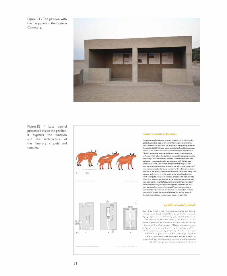
The pavilion and its panels
In January 2017, we built a visitors’ pavilion on the southern edge of the cemetery, close to the Eastern Deffufa. Designed by the architect Ana Canosa, it was inspired by vernacular architecture while seeking to be contemporary (Honegger and Bundi 2017). With the money received from the QSAP in October 2017, we also produced five new panels with pictures and English-Arabic text (figure 31). These panels have been designed for visitors in order to explain for their benefit the main characteristics of the Eastern Cemetery of Kerma, located four kilometres east of the ancient town of Kerma. The first panel displays a plan of the Eastern Cemetery, showing its large area (75 hectares), the location of the main tombs and explains how the ongoing and archaeological excavations of the past 100 years have revealed the development of the cemetery from north to south, with royal tombs that became progressively larger. The second panel shows a reconstitution of the Pre-Kerma agglomeration dating from about 3000 BCE located at the centre of the cemetery; it explains that the settlement was surrounded by a fortification wall several metres thick and that the population, which practiced agriculture and animal husbandry, must have been the forerunners of the Kerma civilisation. The third panel describes the funerary rituals at Kerma and the principal changes that occurred over time. The fourth panel shows the most recent royal tombs of the cemetery, dating to Classic Kerma and extensively excavated by George A. Reisner over a century ago. The fifth panel shows the funerary chapels and temples belonging to Middle and Classic Kerma, which were built using mud-bricks and that these monuments were located to the north-west of certain tombs of important individuals (figure 32).
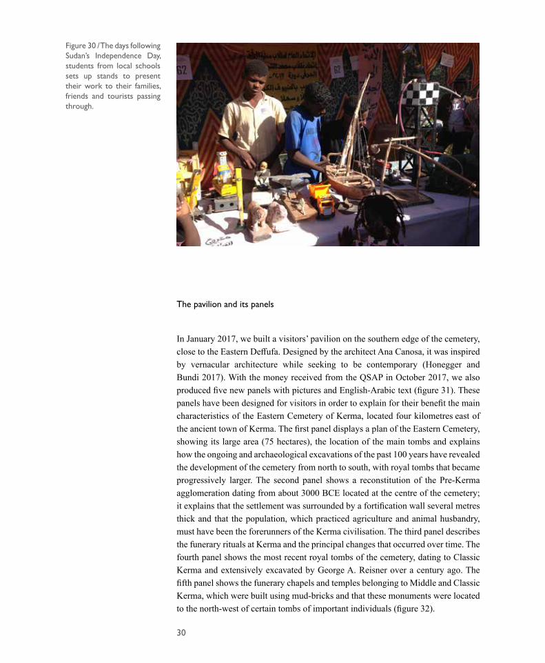
Figure 30 / The days following Sudan’s Independence Day, students from local schools sets up stands to present their work to their families, friends and tourists passing through.
31
Figure 32 / Last pannel presented inside the pavilion. It explains the function and the architecture of the funerary chapels and temples.
Figure 31 / The pavilion with the five panels in the Eastern Cemetery.
الجنائزية والمصليات المعابد مرتبطة طقوس هناك بأن االعتقاد إىل القدمية، كرمة منذ ،)وسقائف أسيجة( القبور حول اخلشبية اهلياكل تقودنا
مبنية احلقيقية املصليات تلك ظهرت ،امليالد قبل 2000 عام حوايل ،الوسطى كرمة بداية منذ ولكن .باملتوىف مث ومن ،أساسي بشكل مستطيلة .مهمني ألفراد حمددة قبور من الغريب الشمال إىل وتقع ،)اآلجر( اللنب بالطوب عليها ورمست تدرجييا، املباين حجم زادو مربعة هندسية خارطة مع قصري وقت بعد أكرب املصليات أصبحت امللكية املقابر آخر مع ارتبطتا خاصة بصفة لإلنتباه املثرية املعابد من اثنان .الكالسيكية كرمة حقبة خالل زخارف
خارطة ولديه .أمتار 10 من أكثر ارتفاع على يقف يزال ال )KII( الشرقية الدفوفة ،منهما واحد .اجلنوب إىل السطح رواق اىل يصعد درج على وحيتوي ،ياآلخر خلف مهااحدا ،مستطيلتني نيكبريت غرفتني من ألفتت هندسية عليه ُحنت موحد رباعي عتب مع ،اجلنوب يف صروحيال املدخل يقعو .متجانسة مسالت تراصت حيث العلوي خليتانالدا القاعتان بقيتو ،الرياح بتعرية كثريا تأثر قدو )KXI( بقليل قبله كان الثاين املعبدو .جمنح قرص ،)واألبقار النهر وفرس الزراف( اإلفريقية احليوانات ثلمت بصور جدراهنما وحتتفظ واحد مرت حوايل ارتفاع على
،املعبدين هذين اجتاه يتميزو .ثورين بني وقتال الصحراوية واحليوانات القوارب مثل ،اليومية احلياة مشاهد وكذلك .الَلِنب الطوب من مصنوع مغلق مبحراب لكرمة، القدمية ةاملدين يف الغربية الدفوفة مع احلال هو كما
القدمية املدينة يف KI مبعبد مقارنة ، KXI و KII اجلنائزية املعابد
32
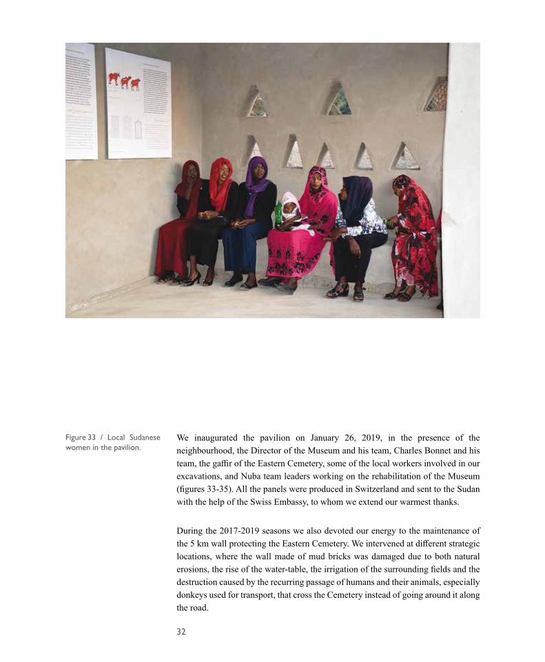
We inaugurated the pavilion on January 26, 2019, in the presence of the neighbourhood, the Director of the Museum and his team, Charles Bonnet and his team, the gaffir of the Eastern Cemetery, some of the local workers involved in our excavations, and Nuba team leaders working on the rehabilitation of the Museum (figures 33-35). All the panels were produced in Switzerland and sent to the Sudan with the help of the Swiss Embassy, to whom we extend our warmest thanks.
During the 2017-2019 seasons we also devoted our energy to the maintenance of the 5 km wall protecting the Eastern Cemetery. We intervened at different strategic locations, where the wall made of mud bricks was damaged due to both natural erosions, the rise of the water-table, the irrigation of the surrounding fields and the destruction caused by the recurring passage of humans and their animals, especially donkeys used for transport, that cross the Cemetery instead of going around it along the road.
Figure 33 / Local Sudanese women in the pavilion.

33
Figure 34 / The pavilion is located on the edge of the cemetery, close to the Eastern Deffufa.
Figure 35 / This open public building is not only intended for tourists but also for the neighbourhood. The text of the pannels written in arabic and english, tells the story of their place.
34
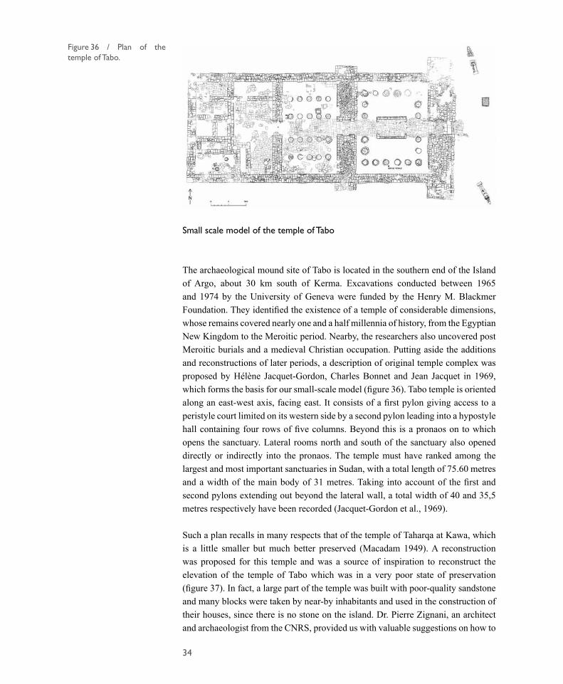
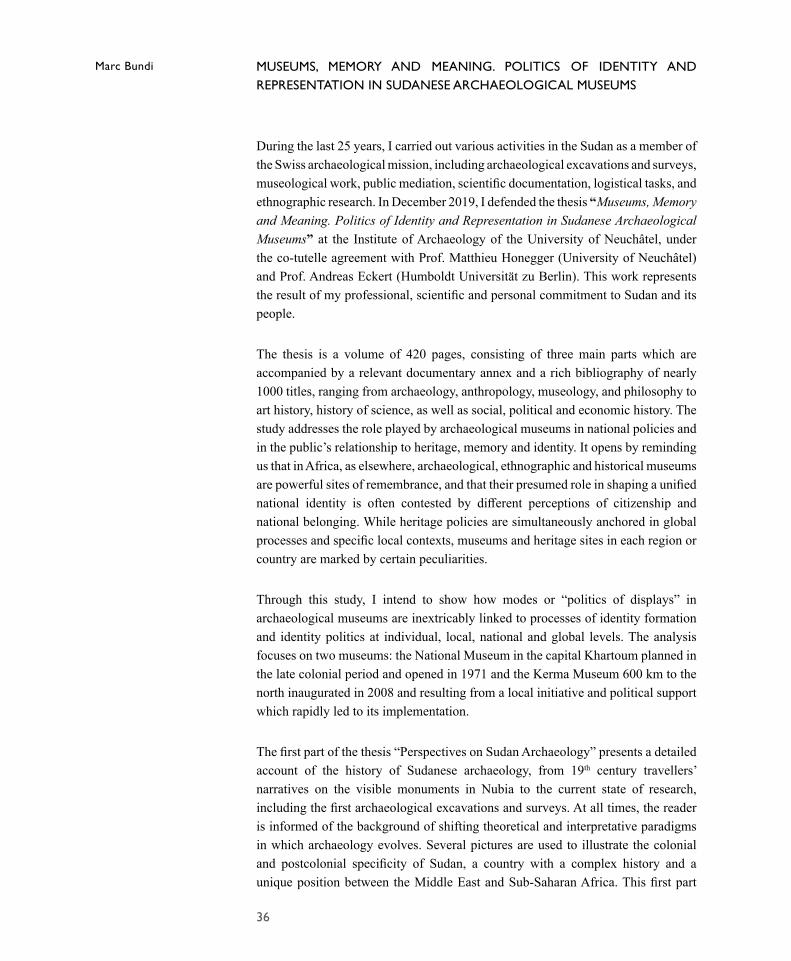
Small scale model of the temple of Tabo
The archaeological mound site of Tabo is located in the southern end of the Island of Argo, about 30 km south of Kerma. Excavations conducted between 1965 and 1974 by the University of Geneva were funded by the Henry M. Blackmer Foundation. They identified the existence of a temple of considerable dimensions, whose remains covered nearly one and a half millennia of history, from the Egyptian New Kingdom to the Meroitic period. Nearby, the researchers also uncovered post Meroitic burials and a medieval Christian occupation. Putting aside the additions and reconstructions of later periods, a description of original temple complex was proposed by Hélène Jacquet-Gordon, Charles Bonnet and Jean Jacquet in 1969, which forms the basis for our small-scale model (figure 36). Tabo temple is oriented along an east-west axis, facing east. It consists of a first pylon giving access to a peristyle court limited on its western side by a second pylon leading into a hypostyle hall containing four rows of five columns. Beyond this is a pronaos on to which opens the sanctuary. Lateral rooms north and south of the sanctuary also opened directly or indirectly into the pronaos. The temple must have ranked among the largest and most important sanctuaries in Sudan, with a total length of 75.60 metres and a width of the main body of 31 metres. Taking into account of the first and second pylons extending out beyond the lateral wall, a total width of 40 and 35,5 metres respectively have been recorded (Jacquet-Gordon et al., 1969).
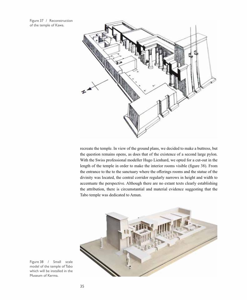
Such a plan recalls in many respects that of the temple of Taharqa at Kawa, which is a little smaller but much better preserved (Macadam 1949). A reconstruction was proposed for this temple and was a source of inspiration to reconstruct the elevation of the temple of Tabo which was in a very poor state of preservation (figure 37). In fact, a large part of the temple was built with poor-quality sandstone and many blocks were taken by near-by inhabitants and used in the construction of their houses, since there is no stone on the island. Dr. Pierre Zignani, an architect and archaeologist from the CNRS, provided us with valuable suggestions on how to
Figure 36 / Plan of the temple of Tabo.
35
recreate the temple. In view of the ground plans, we decided to make a buttress, but the question remains opens, as does that of the existence of a second large pylon. With the Swiss professional modeller Hugo Lienhard, we opted for a cut-out in the length of the temple in order to make the interior rooms visible (figure 38). From the entrance to the to the sanctuary where the offerings rooms and the statue of the divinity was located, the central corridor regularly narrows in height and width to accentuate the perspective. Although there are no extant texts clearly establishing the attribution, there is circumstantial and material evidence suggesting that the Tabo temple was dedicated to Amun.
Figure 38 / Small scale model of the temple of Tabo which will be installed in the Museum of Kerma.
Figure 37 / Reconstruction of the temple of Kawa.
36
MUSEUMS, MEMORY AND MEANING. POLITICS OF IDENTITY AND REPRESENTATION IN SUDANESE ARCHAEOLOGICAL MUSEUMS
During the last 25 years, I carried out various activities in the Sudan as a member of the Swiss archaeological mission, including archaeological excavations and surveys, museological work, public mediation, scientific documentation, logistical tasks, and ethnographic research. In December 2019, I defended the thesis “Museums, Memory and Meaning. Politics of Identity and Representation in Sudanese Archaeological Museums” at the Institute of Archaeology of the University of Neuchâtel, under the co-tutelle agreement with Prof. Matthieu Honegger (University of Neuchâtel) and Prof. Andreas Eckert (Humboldt Universität zu Berlin). This work represents the result of my professional, scientific and personal commitment to Sudan and its people.
The thesis is a volume of 420 pages, consisting of three main parts which are accompanied by a relevant documentary annex and a rich bibliography of nearly 1000 titles, ranging from archaeology, anthropology, museology, and philosophy to art history, history of science, as well as social, political and economic history. The study addresses the role played by archaeological museums in national policies and in the public’s relationship to heritage, memory and identity. It opens by reminding us that in Africa, as elsewhere, archaeological, ethnographic and historical museums are powerful sites of remembrance, and that their presumed role in shaping a unified national identity is often contested by different perceptions of citizenship and national belonging. While heritage policies are simultaneously anchored in global processes and specific local contexts, museums and heritage sites in each region or country are marked by certain peculiarities.
Through this study, I intend to show how modes or “politics of displays” in archaeological museums are inextricably linked to processes of identity formation and identity politics at individual, local, national and global levels. The analysis focuses on two museums: the National Museum in the capital Khartoum planned in the late colonial period and opened in 1971 and the Kerma Museum 600 km to the north inaugurated in 2008 and resulting from a local initiative and political support which rapidly led to its implementation.
The first part of the thesis “Perspectives on Sudan Archaeology” presents a detailed account of the history of Sudanese archaeology, from 19th century travellers’ narratives on the visible monuments in Nubia to the current state of research, including the first archaeological excavations and surveys. At all times, the reader is informed of the background of shifting theoretical and interpretative paradigms in which archaeology evolves. Several pictures are used to illustrate the colonial and postcolonial specificity of Sudan, a country with a complex history and a unique position between the Middle East and Sub-Saharan Africa. This first part
Marc Bundi
37
also demonstrates that the increasing institutionalisation and professionalisation of Sudanese archaeology have contribute to the creation of the Sudan Antiquities Service and to the establishment of archaeological and heritage museums. It describes the cultural heritage and memory, the institutional environments and the various facets of the socio-political context and, therefore, the conditions for the application of museum practices outlined in the following parts.
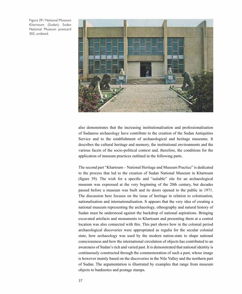
The second part “Khartoum – National Heritage and Museum Practice” is dedicated to the process that led to the creation of Sudan National Museum in Khartoum (figure 39). The wish for a specific and “suitable” site for an archaeological museum was expressed at the very beginning of the 20th century, but decades passed before a museum was built and its doors opened to the public in 1971. The discussion here focuses on the issue of heritage in relation to colonisation, nationalisation and internationalisation. It appears that the very idea of creating a national museum representing the archaeology, ethnography and natural history of Sudan must be understood against the backdrop of national aspirations. Bringing excavated artefacts and monuments to Khartoum and presenting them at a central location was also connected with this. This part shows how in the colonial period archaeological discoveries were appropriated as regalia for the secular colonial state, how archaeology was used by the modern nation-state to shape national consciousness and how the international circulation of objects has contributed to an awareness of Sudan’s rich and varied past. It is demonstrated that national identity is continuously constructed through the commemoration of such a past, whose image is however mainly based on the discoveries in the Nile Valley and the northern part of Sudan. The argumentation is illustrated by examples that range from museum objects to banknotes and postage stamps.
Figure 39 / National Museum Khartoum (Sudan). Sudan National Museum postcard 303, undated.
38
Figure 40 / Leaflet “Civilization Kerma-Deffufa”. Union of Kerma Students. Undated.
Figure 41 / Postage stamps inscribed “King Taharka 668-663 B.C.”. Issued in 1991 at a nominal value of 250 piasters.
39
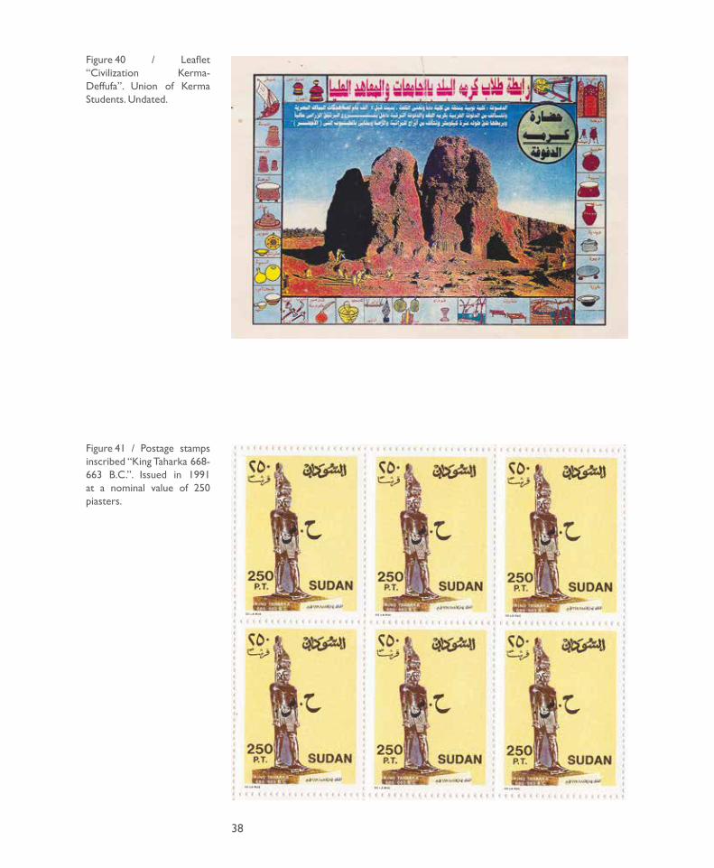
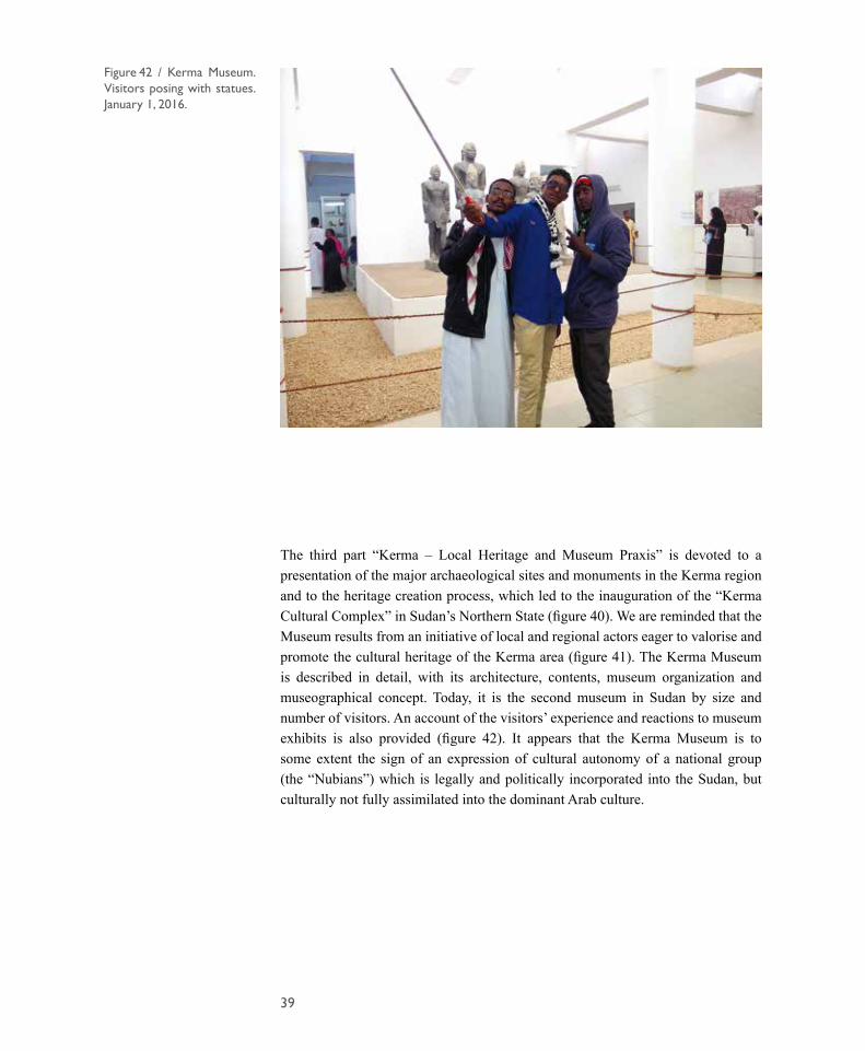
The third part “Kerma – Local Heritage and Museum Praxis” is devoted to a presentation of the major archaeological sites and monuments in the Kerma region and to the heritage creation process, which led to the inauguration of the “Kerma Cultural Complex” in Sudan’s Northern State (figure 40). We are reminded that the Museum results from an initiative of local and regional actors eager to valorise and promote the cultural heritage of the Kerma area (figure 41). The Kerma Museum is described in detail, with its architecture, contents, museum organization and museographical concept. Today, it is the second museum in Sudan by size and number of visitors. An account of the visitors’ experience and reactions to museum exhibits is also provided (figure 42). It appears that the Kerma Museum is to some extent the sign of an expression of cultural autonomy of a national group (the “Nubians”) which is legally and politically incorporated into the Sudan, but culturally not fully assimilated into the dominant Arab culture.
Figure 42 / Kerma Museum. Visitors posing with statues. January 1, 2016.
40
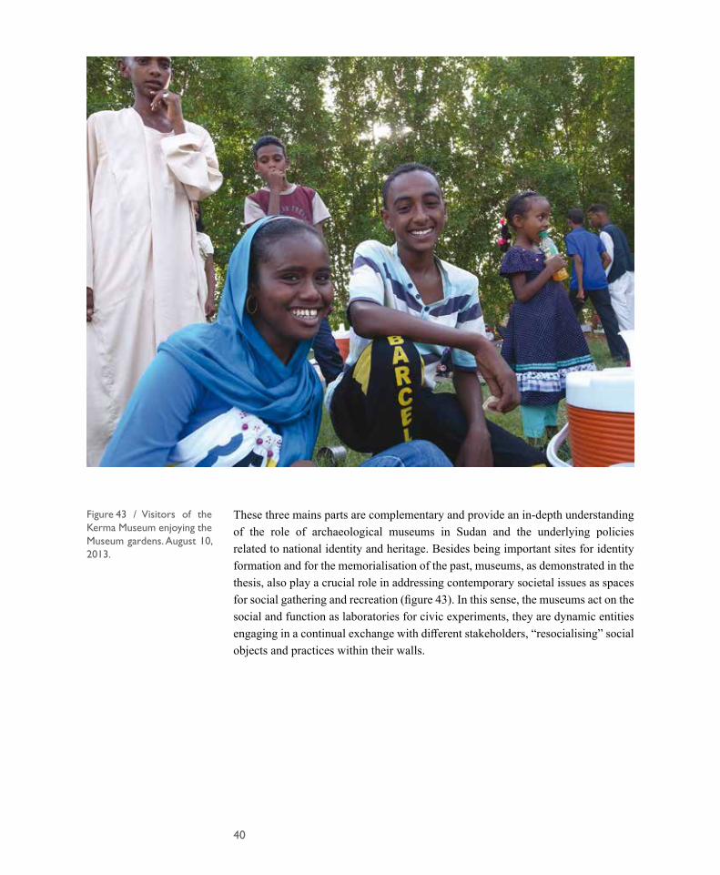
These three mains parts are complementary and provide an in-depth understanding of the role of archaeological museums in Sudan and the underlying policies related to national identity and heritage. Besides being important sites for identity formation and for the memorialisation of the past, museums, as demonstrated in the thesis, also play a crucial role in addressing contemporary societal issues as spaces for social gathering and recreation (figure 43). In this sense, the museums act on the social and function as laboratories for civic experiments, they are dynamic entities engaging in a continual exchange with different stakeholders, “resocialising” social objects and practices within their walls.
Figure 43 / Visitors of the Kerma Museum enjoying the Museum gardens. August 10, 2013.

41
BIBLIOGRAPHY
Beyin, A., Chauhan, P.R. and Nassr, A. 2019. “Reconnaissance of Prehistoric Sites in the Red Sea Coastal Region of the Sudan, NE Africa”, Journal of Field Archaeology, 44, 3: 147-164.
Beyin, A., Hall, J. and Day, C.A. 2019. “A Least Cost Path Model for hominin dispersal routes out of the East African Rift region (Ethiopia) into the Levant”, Journal of Archaeological Science: Reports, 23, 763-772.
Bonnet, C. 1999. “Archaeological excavations at Kerma (Sudan): preliminary report for the seasons 1997-98 and 1998-99”, in: Bonnet, C. et al. Les fouilles archéologiques de Kerma (Soudan), Geneva, ns, 47: 57-75.
Bonnet, C. 2000. Edifices et rites funéraires à Kerma. Paris : Errance.
Dunham, D. 1982. Excavations at Kerma. Part VI : subsidiary nubian graves, excavated by the late George A. Reisner in 1915-1916, not included in his Excavations at Kerma, I-III and IV-V, published by him in the Harvard African Studies, V and VI, 1923. Boston: Museum of Fine Arts.
Goder-Goldberger, M. 2013. “The Khormusan: evidence for an MSA East African industry in Nubia”, Quaternary International, 300, 182-194.
Goder-Goldberger, M. 2014. Lithic variability along the Middle Paleolithic dispersal routes of modern humans’ Out of Africa’. Hebrew University of Jerusalem. Unpublished Thesis.
Groucutt, H.S., Petraglia, M.D., Bailey, G., Scerri, E.M., Parton, A., Clark-Balzan, L., Jennings, R.P., Lewis, L., Blinkhorn, J. and Drake, N.A. 2015. “Rethinking the dispersal of Homo sapiens out of Africa”, Evolutionary Anthropology: Issues, News, and Reviews, 24, 4: 149-164.
Honegger, M. 2018a. “New Data on the Origins of Kerma”, in: Honegger M. (ed.), Nubian Archaeology in the XXIst Century, Proceedings of the 13th International Conference of the Society for Nubian Studies. Publications de la Mission Archéologique Suisse à Kerma, 1: 19-34.
Honegger, M. 2018b. “La plus ancienne tombe royale du royaume de Kerma en Nubie”, Bulletin de la Société Neuchâteloise des Sciences Naturelles, 138: 185-198.
Honegger, M. and Bundi, M. 2017. “Protection and valorization works in the Eastern Cemetery and the Museum”, Kerma, Documents de la mission archéologique suisse au Soudan, 7: 17-19.
42
Honegger, M. and Williams, M. 2015. “Human occupations and environmental changes in the Nile valley during the Holocene: the case of Kerma in Upper Nubia (Northern Sudan)”, Quaternary Science Reviews, 130, 141-154.
Jacquet-Gordon, H., Bonnet, C. and Jacquet, J. 1969. “Pnubs and the temple of Tabo on Argo island”, The Journal of Egyptian Archaeology, 55, 1: 103-111.
Macadam, M.F.L. 1949. The Temples of Kawa. London: Oxford University Press.
Marks, A.E. 1968. “The Khormusan: an Upper Pleistocene industry in Sudanese Nubia”, The Prehistory of Nubia, 1, 315-391.
Marks, A.E., Peters, J. and Van Neer, W. 1987. “Late Pleistocene and Early Holocene Occupations in the Upper Atbara River Valley, Sudan”, in: Close A.E. (ed.), Prehistory of Arid North Africa. Essays in Honor of Fred Wendorf. Dallas: Southern Methodist University Press: 137-161.
Olszewski, D., Baker, B. and Rempel, S. 2019. “The Middle Stone Age Record in Egypt and Sudan: Implications for Out of Africa 2”, 84th Annual Meeting of the SAA, Albuquerque, NM.
Maystre, C. et al. 1986. Tabo I: Statue en bronze d’un roi méroïtique. Genève: Georg.
Reisner, G.A. 1923. Excavations at Kerma I-III and IV-V. Cambridge: Peabody Museum of Harvard University.
Rose, J. and Marks, A. 2014. “Out of Arabia” and the Middle-Upper Palaeolithic transition in the southern Levant”, Quartär, 61, 49-85.
Rose, J.I., Usik, V.I., Marks, A.E., Hilbert, Y.H., Galletti, C.S., Parton, A., Geiling, J.M., Černý, V., Morley, M.W. and Roberts, R.G. 2011. “The Nubian complex of Dhofar, Oman: an African middle stone age industry in southern Arabia”, PloS one, 6, 11: e28239.
Van Peer, P. 1998. “The Nile corridor and the out-of-Africa model an examination of the archaeological record”, Current Anthropology, 39, S1: S115-S140.
Van Peer, P., Fullagar, R., Stokes, S., Bailey, R., Moeyersons, J., Steenhoudt, F., Geerts, A., Vanderbeken, T., De Dapper, M. and Geus, F. 2003. “The Early to Middle Stone Age transition and the emergence of modern human behaviour at site 8-B-11, Sai Island, Sudan”, Journal of Human Evolution, 45, 2: 187-193.
Williams, M. 2019. The Nile basin: Quaternary geology, geomorphology and prehistoric environments. Cambridge: Cambridge University Press.

43
Matthieu Honegger
Jérôme Dubosson
Jean Montandon
Nuno Bicho and Jonathan Haws
Giovanni Foletti
Maystre et al. 1986
Macadam 1949
Unknown author
Marc Bundi
FIGURES
Figures 1, 2, 5, 7, 8, 10-15, 22-25, 28, 29, 31, 32, 34, 35, 38
Figures 3, 4, 9, 26, 27, 30
Figure 6
Figures 16-21
Figure 33
Figure 36
Figure 37
Figures 39-41
Figures 42-43


© 2019 Institut d’archéologie, Université de NeuchâtelISSN : 1663-2656
SUMMARY
Archaeological Excavations at Kerma (Sudan)Preliminary Report of the 2017-2018 and 2018-2019 seasons
The Eastern Cemetery of Kerma and its first royal graves
First results of a Middle Stone Age survey in the Kerma region, northern Sudan
Museum rehabilitation and valorisation of the Eastern Cemetery
Museums, Memory and Meaning. Politics of Identity and Representation in Sudanese Archaeological Museums
Matthieu Honegger
Matthieu Honegger,
Nuno Bicho, Jonathan Haws andMatthieu Honegger
Matthieu Honegger and Jérôme Dubosson
Marc Bundi