B oum rt - pyrenees-atlantiques.gouv.fr
1
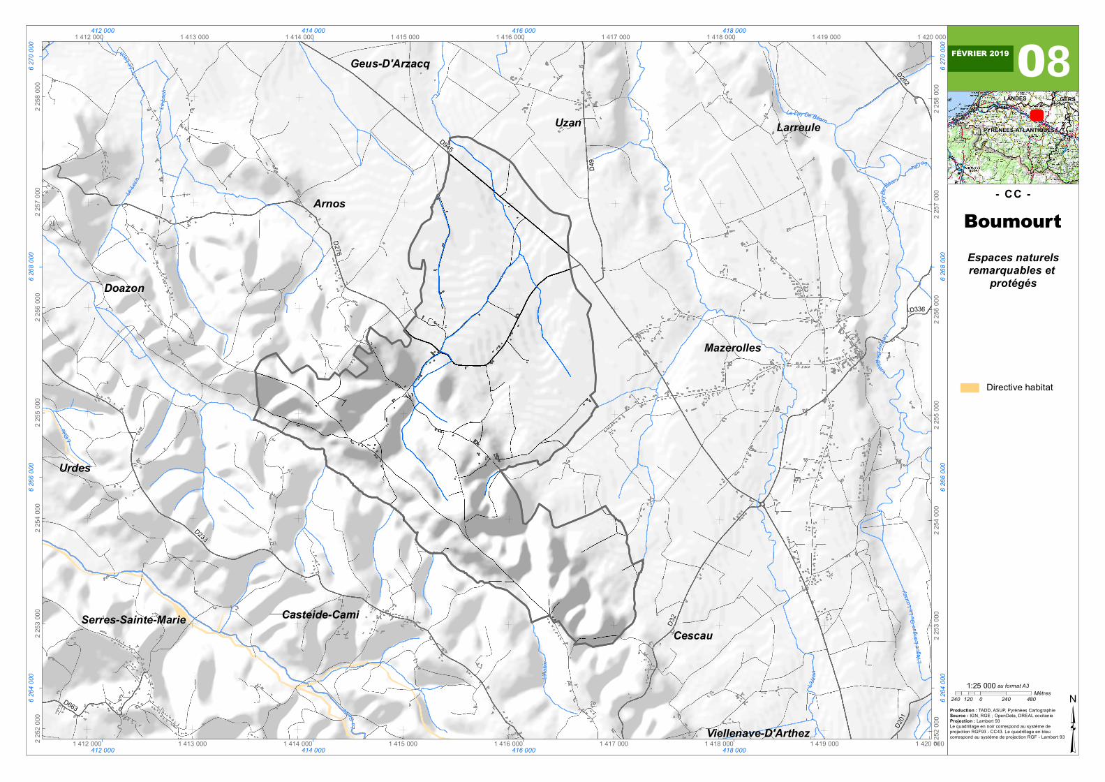
L ' A i g u e L o n g u e O u L e Louss y L ' U z a n L ' O rl e Le G e z Le Lech L'Aubin Le Le c h Le L u y D e Bé a r n L e L e c h L a G e ul e L e Lu y D e B é a rn L e Luy De B éa rn D 2 62 D 3 2 D 3 3 6 D6 6 3 D 2 3 3 D276 D201 D945 D49 Mazerolles Serres-Sainte-Marie Urdes Uzan Casteide-Cami Arnos Cescau Geus-D'Arzacq Larreule Viellenave-D'Arthez Doazon 1 412 000 1 412 000 1 413 000 1 413 000 1 414 000 1 414 000 1 415 000 1 415 000 1 416 000 1 416 000 1 417 000 1 417 000 1 418 000 1 418 000 1 419 000 1 419 000 1 420 000 1 420 000 2 252 000 2 252 000 2 253 000 2 253 000 2 254 000 2 254 000 2 255 000 2 255 000 2 256 000 2 256 000 2 257 000 2 257 000 2 258 000 2 258 000 412 000 412 000 414 000 414 000 416 000 416 000 418 000 418 000 6 264 000 6 264 000 6 266 000 6 266 000 6 268 000 6 268 000 6 270 000 6 270 000 08 Espaces naturels remarquables et protégés - CC - ³ Production : TADD, ASUP, Pyrénées Cartographie Source : IGN, RGE ; OpenData, DREAL occitanie Projection : Lambert 93 Le quadrillage en noir correspond au système de projection RGF93 - CC43. Le quadrillage en bleu correspond au système de projection RGF - Lambert 93 GERS LANDES PYRENEES-ATLANTIQUES 240 0 240 480 120 Mètres 1:25 000 au format A3 Boumourt FÉVRIER 2019 Directive habitat
Transcript of B oum rt - pyrenees-atlantiques.gouv.fr
L'Aigu
eLon
gueO
uLeL
oussy
L'Uza
n
L'Orle
LeGez
Le Lec
h
L'Aub
in
LeLe
ch
LeLu
yDeB
éarn
LeLe
ch
LaGe
ule
LeLuyDeB éarn
Le Luy De Béarn
D262
D32
D336
D663
D233
D276
D201
D945
D49
Mazerolles
Serres-Sainte-Marie
Urdes
Uzan
Casteide-Cami
Arnos
Cescau
Geus-D'Arzacq
Larreule
Viellenave-D'Arthez
Doazon
1 412 000
1 412 000
1 413 000
1 413 000
1 414 000
1 414 000
1 415 000
1 415 000
1 416 000
1 416 000
1 417 000
1 417 000
1 418 000
1 418 000
1 419 000
1 419 000
1 420 000
1 420 0002 252
000
2 252
000
2 253
000
2 253
000
2 254
000
2 254
000
2 255
000
2 255
000
2 256
000
2 256
000
2 257
000
2 257
000
2 258
000
2 258
000
412 000
412 000
414 000
414 000
416 000
416 000
418 000
418 000
6 264
000
6 264
000
6 266
000
6 266
000
6 268
000
6 268
000
6 270
000
6 270
000 08
Espaces naturelsremarquables et
protégés
- CC -
³Production : TADD, ASUP, Pyrénées CartographieSource : IGN, RGE ; OpenData, DREAL occitanieProjection : Lambert 93Le quadrillage en noir correspond au système deprojection RGF93 - CC43. Le quadrillage en bleucorrespond au système de projection RGF - Lambert 93
GERSLANDES
PYRENEES-ATLANTIQUES
240 0 240 480120Mètres
1:25 000 au format A3
Boumourt
FÉVRIER 2019
Directive habitat