THÈSE - ur-green.cirad.fr · Especially to Martine Antona, Cecile Barnaud, Aurelie Botta...
495
THÈSE pour l’obtention du grade de Docteur en géographie humaine, économique et régionale de l’Université Paris Ouest Nanterre-La Défense présentée et soutenue publiquement le 29 janvier 2013 par Daniel Castillo Brieva Arrangements institutionnels et modèles mentaux dans la gestion des ressources en bien commun JURY E. Brondisio Professeur, Indiana University, Rapporteur J.C.Cardenas Professeur, Universidad de Los Andes, Rapporteur F. Landy Professeur, Univ. Paris X R. Mathevet CNRS, CEFE M. Janssen Assoc. Professor, Arizona State University F. Bousquet CIRAD, directeur de thèse
Transcript of THÈSE - ur-green.cirad.fr · Especially to Martine Antona, Cecile Barnaud, Aurelie Botta...
THÈSE
pour l’obtention du grade de
Docteur en géographie humaine, économique et régionale
de l’Université Paris Ouest Nanterre-La Défense
présentée et soutenue publiquement le 29 janvier 2013
par
Daniel Castillo Brieva
Arrangements institutionnels et modèles mentaux dans la gestion
des ressources en bien commun
JURY E. Brondisio Professeur, Indiana University, Rapporteur
J.C.Cardenas Professeur, Universidad de Los Andes, Rapporteur
F. Landy Professeur, Univ. Paris X
R. Mathevet CNRS, CEFE
M. Janssen Assoc. Professor, Arizona State University
F. Bousquet CIRAD, directeur de thèse
1
ACKNOWLEDGEMENTS
This dissertation is the product of an itelectual and phisical journey of nearly six years
through the field of institutional analysis and the use and management of common pool
resources. During these years many people have support this work. All these persons have
generously shared their time, ideas and expertise with me, which has been fundamental to
develop my ideas and analysies. There are a few people who I want to thank specifically.
I am in debt with my advisor François Bousquet whose inmense academic and
human generosity oriented me throughout the research. I want to thank the friendship with
Juan Camilo Cárdenas who has supported me in many ways from my early days in the
institutional field. He has been always open to academic and personal fruitful discussions
that have fed this work. Marco Janssen also has been a very important person in my work.
He has been always open to discussions and ideas. Thanks to Marco I could enyoy, during
one semester, the intellectually exiting environment of the Center for the Study of
Institutional Diversity (Arizona State University). I want also to thank Elinor and Vincent
Ostrom whose work has inspired this research. Lin`s advice was iluminating in crucial
moments of this journey.
Finnancially, the research has been supported by several institutions and projects.
My home university, the Universidad Javeriana has supported me during four years. The
program of the European Union, HUMCRICON, has provided a Marie Curie fellowship of
one year at the University of Deusto (Spain). The Center for the Study of Institutional
Diversity (Arizona State University) provided me with a visiting scholar position during
one semester. The support for the fieldwork was provided by project “The Dynamic of
Rules in Commons Dilemmas”. The Centre de coopération internationale en recherche
agronomique pour le dé velopement (CIRAD) through the research unit GREEN (Gestion
de ressources renouvelables et de l`environnemment) has supported me during my
Montpellier stays and partially the field work throughout Jean François Tourrand. I want to
thank all of them.
I want to express my gratitude to the people of the GREEN team at CIRAD in
Montpellier. Especially to Martine Antona, Cecile Barnaud, Aurelie Botta Christophe Le
2
Page, Trébuil Guy and Nathalie Rovis. All of them have contributed with ideas and
hospitality in my stays in France.
There were several people that contribute by reading, exchanging ideas and offering
information for this work: Gloria Restrepo, Maria Claudia López, Juan Camilo Cárdenas,
Marco Janssen, Elcy Corrales, Brigitte Luis Guillermo Baptiste, Diana Maya, Andrés
Castillo, Olga Lucia Castillo, Murray Rudd, Nick Abel, Tim Lynam. Thanks to all.
I want to thank specially to Mauricio Baquero who helped me with the maps, and
Manuel Salamanca who corrected the final document.
This research has not been possible without the help, hospitality, knowledge and
generousity of the people who live in Barú, Lenguazaque and Salahonda, the commons
users. I mention some of them because of space reasons: Enrique Villamil, Wilner Gómez,
Wilfredo Gómez, Ana Sixta Pacheco, Gabriel Gómez, Ana Granja, Wilson Cuervo and and
nearly 150 people who participated in the research in the sites.
Finally I want to express my inmense gratitude, admiration and love to Gloria. She
has been the engine, personal and intelectually, of this journey. Many of the most relevant
ideas of this dissertation are the consequence of our long conversations. She has also been a
key part in the fieldwork. She has been the life support during these years. This work is also
her achievement. I am in debt with her for life. I can only say thank you.
3
“Vue de haut, dans ses rapports avec l’Homme, la Géographie n’est autre
chose que l’Histoire dans l’espace, de même que l’Histoire est la Géographie
dans le temps.
Ne peut-on dire également que l’Homme est la Nature prenant conscience
d’elle-même ?”
“Vista desde arriba, en sus relaciones con el hombre, la geografía no es otra
cosa que la historia en el espacio, lo mismo que la historia es la geografía en
el tiempo.
¿No podríamos decir igualmente, que el hombre es la naturaleza tomando
conciencia de sí misma?”
Elisée Reclus
L'Homme et la Terre, 1905 (Tome 1, p. 5)
´

4
“New ideas arise from recombination of the old”
John Holland
4
CONTENTS
1 INTRODUCTION ............................................................................................................. 8
1.1 World’s major common pool resources ....................................................................... 9
1.1.1 Fisheries ..................................................................................................................... 9
1.1.2 Forests ...................................................................................................................... 11
1.1.3 Water ....................................................................................................................... 12
1.2 Problem of research...................................................................................................... 13
1.3 Outline of the dissertation ............................................................................................ 16
2 THEORETICAL AND ANALYTICAL APPROACHES .......................................... 18
2.1 The Commons Dilemma ............................................................................................... 19
2.1.1. The “conventional” theory...................................................................................... 21
2.1.2. Common Pool Resources (CPR) ............................................................................ 24
2.2. Common pool resources management ....................................................................... 27
2.2.1. Social Ecological Systems (SES) ........................................................................... 28
2.3. Mental Models ............................................................................................................. 33
2.3.1. Definitions of mental models ................................................................................. 34
2.3.2 The general structure of human learning process .................................................... 45
2.3.3 Cognitive processes ................................................................................................. 50
2.3.4 Mental models and governance of SESs ................................................................. 53
2.4. Institutional Analysis and Development (IAD) framework ..................................... 54
2.4.1 Definition of institutions .......................................................................................... 55
2.4.2. The Institutional Analysis and Development Framework (IAD) ........................... 56
2.5. A framework for the analysis of governance of Social-Ecological Systems (SESs)
.......................................................................................................................................... 72
2.5.1 From Core Relationships in Commons Dilemmas to the Broader Context of a SES
.......................................................................................................................................... 74
2.6 Conclusion ..................................................................................................................... 76
5
3 METHODOLOGICAL FRAMEWORK ...................................................................... 83
3.1 Research posture .......................................................................................................... 84
3.1.1 Companion modeling and co-management of common pool resources.................. 85
3.1.2 Management, participation and modeling tools ...................................................... 86
3.1.3 Companion modeling and experimental economics ................................................ 88
3.2 Methodological process and tools .............................................................................. 91
3.2.1 Phase 1: Definition of the SES ................................................................................ 95
3.2.2 Phase 2: Field Experiments ..................................................................................... 95
3.2.3 Phase 3: Collective construction of a role-palying game (RPG) ........................... 105
3.2.4 Phase 4: Implementation of the role-palying game (RPG).................................... 107
3.3 Conclusion ................................................................................................................ 108
4. GEOGRAPHICAL AND HISTORICAL CONTEXT .............................................. 109
4.1. Fishermen community of Isla Barú ......................................................................... 112
4.1.1. The Coastal Colombian Caribbean region............................................................ 112
4.1.2. The biophysical environment ............................................................................... 113
4.1.3 Barú: The social system ......................................................................................... 121
4.1.4 Barú today ............................................................................................................. 126
4.1.6. Barú: Problems and Potential Shocks ................................................................... 133
4.2. Forestry community of Salahonda ........................................................................... 135
4.2.1. The Pacific lowlands ............................................................................................ 135
4.2.2. The biophysical environment ............................................................................... 137
4.2.3. Salahonda: The social system ............................................................................... 141
4.2.4. Salahonda: Economic activities ............................................................................ 147
4.2.5. Salahonda: Territory, space conceptions, and social organization ....................... 150
4.2.6 Salahonda: Problems and Potential Shocks ........................................................... 152
4.3. Aqueduct community of Lenguazaque village ........................................................ 154
4.3.1. The Central Colombian Andean Region .............................................................. 154
4.3.2. Lenguazaque: The biophysical environment ........................................................ 155
4.3.3 The aqueduct.......................................................................................................... 169
4.3.3. Lenguazaque: The Social System ......................................................................... 161
4.3.4. Lenguazaque: Problems and Potential Shocks ..................................................... 170
4.4 Synthesis of the case studies contexts ........................................................................ 172
6
4.4.1 Resource System (RS) ........................................................................................... 172
4.4.2 Resource Units (RU) ............................................................................................. 175
4.4.3 Governance system (RU) ...................................................................................... 176
4.4.4 Users (U) ............................................................................................................... 179
4.4.5 Interactions (I) ....................................................................................................... 183
5 INSTITUTIONAL ANALYSIS .................................................................................... 187
5.1 The Fishery System .................................................................................................... 189
5.1.1 Outcomes of the experimental action situation ..................................................... 189
5.1.2 Collective construction of the fishery RPG ........................................................... 192
5.1.3 Outcomes of the RPG action situation .................................................................. 202
5.1.4 The institutional arrangements in the fishery SES ................................................ 206
5.1.5 Outcomes of the SES’ action situation .................................................................. 218
5.1.6 Summary of main findings of fishery system's institutional analysis ................... 225
5.2 The Forestry System ................................................................................................... 227
5.2.1 Outcomes of the forestry experimental action situation ........................................ 227
5.2.2 Collective construction of the forestry RPG ......................................................... 232
5.2.3 Outcomes of the forestry RPG action situation ..................................................... 250
5.2.4 Institutional arrangements in the forestry SES ...................................................... 254
5.2.5 Outcomes of the forestry SES’ action situation..................................................... 264
5.2.6 Summary of main findings of the forestry system’s institutional analysis............ 271
5.3 The Water Use System ............................................................................................... 273
5.3.1 Outcomes of the irrigation experimental action situation ..................................... 273
5.3.2 Towards a more complex action arena: Collective construction of the water RPG
........................................................................................................................................ 284
5.3.3 Outcomes of the water RPG action situation......................................................... 290
5.3.4 Institutional arrangements in the water SES ......................................................... 291
5.3.5 Outcomes of the water system’ action situation .................................................... 299
5.3.6 Summary of main findings of aqueduct system's institutional analysis ................ 305
6 MENTAL MODELS .................................................................................................... 309
6.1 Introduction ................................................................................................................ 309
6.2 Methodology ................................................................................................................ 314
7
6.2.1. Elicitation of mental models ................................................................................. 315
6.2.2. Content analysis for mental models construction ................................................. 317
6.2.3. Network analysis and the building of the collective mental model ...................... 324
6.2.4. Discussion about behavior according mental models, and comparison with
behavior in economic experiments ................................................................................. 325
6.2.5. Relating mental models finding with institutional arrangements and SES’ context
........................................................................................................................................ 326
6.3 Fishery case: Fishing is a matter of justice............................................................... 327
6.3.1 Fishermen mental models ...................................................................................... 327
6.3.2 Collective mental model (MMC) of the fishery case ............................................ 331
6.3.3 The collective mental model and the fishing socio ecological system .................. 340
6.4 The forestry case: The territory is negotiated in the forest ....................................... 348
6.4.1 Mental model 7 (MM7) Extraction oriented ......................................................... 348
6.4.2 Collective mental model (MMC) of the forestry case ........................................... 350
6.4.3 The collective mental model and the forestry socio ecological system ................ 359
6.5 Mental models in the water case ............................................................................... 366
6.5.1 Mental model 10 (MM10). Water production oriented ......................................... 366
6.5.2 Collective mental model (MMC) of the water case .............................................. 368
6.5.3 The socio ecological system and collective mental model .................................... 375
6.6 Conclusions ................................................................................................................. 382
7. DISCUSSION ................................................................................................................ 386
7.1 The behavioral outcomes of the action arena .......................................................... 387
7.1.1 Lessons from the institutional analysis .................................................................. 387
7.1.2 Lessons from the mental models study and its relation with institutional
arrangements ................................................................................................................... 391
7.2 Methodological lessons ............................................................................................... 400
7.3 Commons, management and moral systems ............................................................ 401
8 CONCLUSIONS ............................................................................................................ 402
REFERENCES ................................................................................................................ 408
APPENDIX I ..................................................................................................................... 428

8
APPENDIX II ................................................................................................................... 432
APPENDIX IV .................................................................................................................. 476
APPENDIX V .................................................................................................................... 487
ABSTRACT ...................................................................................................................... 491
RÉSUMÉ ........................................................................................................................... 492
9
1 INTRODUCTION
An important fraction of major world environmental resources such as fisheries, forests,
water and the atmosphere are common pool resources. These resources are facing multiple
changes at world and local scales due to diverse causes such as climate change,
overharvesting and pollution. These resources support the livelihoods of local communities
as well as regional and national economies all over the world. The assumption that
underlies most of the research and field interventions in the management of these common
pool resources is that all the actors involved share the same basic understanding of the
commons problem.
Common pool resources management entails theoretical and empirical problems at
different scales. Garret Hardin’s influential article (Hardin, 1968) put on the spot the
fundamental problem. When several users of a limited resource that do not hold individual
property on the resource units, they could extract as much units as they want to maximize
their individual benefits without taking into account other´s benefits, or they can coordinate
their actions to produce benefits for all users. The first course of action led to the so-called
“tragedy of the commons” which consists in the collapse of the resource. A solution
proposed by Hardin was the allocation of individual property rights and external
enforcement.
During more than two decades these solutions were followed by national
governments and practitioners to solve the management problem. Only after the boom in
research on common pool resources in the late 1980s and early 1990s (Baland & Platteau,
2000; Fikret Berkes, 1989; McCay & Acheson, 1990; Ostrom, 1990; Wade, 2007) policy
designers started to look at different directions. According to (Agrawal, 2001) it is not
possible to argue that research on common resources has produced substantial changes in
resources management, but it certainly has influenced the perspectives of policy makers.
Since the 1990s the general trends in governmental initiatives towards decentralization and
less top down control policies were designed under the commons research influence.
10
1.1 World’s major common pool resources
In this section I give an overview of the state and the academic debate around the most
relevant common resources: fisheries, forests and water. I will illustrate how the cognitive
dimension has influenced also the scientific discussion at global, local and individual
scales.
1.1.1 Fisheries
In 1884 Thomas Huxley stated “probably all great sea-fisheries are inexhaustible”
(Botsford et al., 1997: 512) at the same time that Ray Lankester expressed his concern
about the depletion of spawning stock and the need for targeting another species (L W
Botsford et al., 1997). During the 20th
century technological and scientific advances
produced an immense harvesting capacity of the marine resources, but overexploitation all
over the world has been an increasing problem recognized at least during the second half of
20th
century (F. Berkes et al., 2006; Jackson et al., 2001; Myers & Worm, 2003). Pauly
et al. (1998) stated: if harvesting current trends continue, it would be only jellyfish and
plankton to fish. This was said in one of the first papers published that warned about the
effects of fisheries in marine ecosystems. Worm et al., (2006) predicted the collapse of
world fisheries by 2048. In Latin America ,which “produces 20% of world marine fish
production and employs more than one million people in predominantly artisanal
production”, fisheries policies since the mid 70s starting by Chile have oriented the sector
towards “a grand experiment that tests assumptions about common property management
and the benefits of free trade in the context of a rapid growth in worldwide demand for fish
and sea food” (Liverman & Vials 2006: 352). Studies about the effects of such policies in
Latin America coincide that the success in the short term was accomplished by sacrifying
the future sustainability (Liverman & Vials, 2006).
Strong discussions have been carried out between marine ecologists and fisheries
scientists about the pessimistic view of the former scholars and the most optimistic of the
latter. For example, from the side of fisheries science, Hilborn et al. (2003) assessed the
state of the world’s fisheries and they concluded that “The total world catch from marine
and freshwater wild stocks has peaked and may be slightly declining” (Hillborn et al.
2003:359), in contrast with Pauly et al. (1998) and Worm et al. (2006) predictions. And
they claim for appropriate institutional incentives for a possible fisheries sustainable future.
A synthesis of this discussion, not always friendly, can be found in Stokstad (2009). In

11
2009 Science published the first joint paper produced by the main research groups in the
two mentioned disciplines called “Rebuilding Global Fisheries” (Worm et al., 2009). The
importance of this publication is that they revised world fishery databases used by different
groups of fisheries scientists and marine ecologists and reinterpreted them. They conclude
that in half of the studied ecosystems “the average exploitation rate has recently declined
and is now at or below the rate predicted to achieve maximum sustainable yield for seven
systems” (Worm et al. 2009: 578), but 63% of the studied fish stocks require rebuilding and
significant decreases in harvesting rates. The study evaluates the state of fisheries
combining stock assesments and ecosystem approaches, therefore the word “system” is
used in the ecological comprehensive sense of “ecosystem”.
Small scale fisheries
Although the critical situation seems to be general, not all fisheries have suffered
the consequences of overexploitation (Acheson, 2004). Among small-scale fisheries, which
include artisanal and subsistence systems (Berkes et al., 2001), it is possible to find
successful stories of resource maintenance. Though small scale fisheries are not well
reported, Worm et al. (2009) estimate that catches were about 21 million tons in 2000 and
around 12 million fishers versus 0.5 million of industrial fishermen. The review of
management tools for rebuilding stocks in small scale fisheries shows that gear restrictions
and closed areas have worked as instruments that have contributed or have been important
tools, but the research shows that the most successful tools are community-based
management or community co-management, which is classified as essential tool in the
studied cases (Worm et al. 2009). These findings could led to misleading interpretations
about a one type of management tools for rebuilding stocks as a panacea. Regarding this
point Worm et al. (2009) state: “Finding the best management tools may depend on the
local context” (Worm et al. 2009: 584). Ostrom (2007) discusses the topic in depth in her
paper “A diagnostic approach for going beyond panaceas”. In order to understand the
causes of depletion trends, the focus has been placed on stock assessment in the North, with
general disciplinary emphasis on biology and economics, and with less intensity in social
science (Berkes et al. 2001). It is also relevant to understand which have been the factors
that have kept some small fisheries on the safe side, avoiding stock depletion.
12
1.1.2 Forests
Though world’s forest loss rates are highly uncertain and error in measurement have
been estimated as +-50% (Achard et al., 2002), United Nations Food and Agriculture
Organization estimates that in the tropics forests are disappearing at a rate of 12% per year,
and for 2005, 36% of the world’s forests were relatively unaffected by human beings
(Stokstad, 2008). World’s forest decrease is about 7 million hectares per year mainly in the
tropics (Sukumar, 2008). But the forest dynamics has had differential regional trends, while
the decreasing tendencies have occurred in tropical areas, in North America and Europe
forest areas have grown (Agrawal et al., 2008).
The distribution of world forest ownership, according (White & Martin, 2005),
shows that 81% of the global forests’ property rights are public and 4% of these are
managed as common resources by communities and indigenous groups. Eighteen percent of
the world forests have private property rights, 7% of these are managed by communities
and indigenous groups as common pool resources. There is an important difference
between developing and developed countries in the percentage of common pool forests. In
developing countries the figure is 22%, while in developed countries is 3%. Knowledge
about relations between forest cover and types of ownership is limited (Agrawal et al.,
2008; Dietz et al., 2003). In contrast with these authors, (Charnley & Poe, 2007) argue that
there is evidence of a more ecologically sustainable forestry, meaning forestry practices
that keep ecosystem integrity while continuing to provide ecosystems’ goods and services,
in communal lands where there are institutional arrangements in which local communities
play central roles in developing management rules. Elinor Ostrom’s research during the last
three decades has offered evidence of successful management of common resources when
institutions are crafted by direct users, and these findings include forest cases.
Governance of forests in the world shows three general patterns in the beginning of
the 21th century. Decentralization of management mainly for low market value forests
which are important for the livelihoods of an important fraction of rural population in
developing countries. Entitlements of forest concessions to logging companies in
developing countries have positioned as a common practice. And the increasing relevance
of certifications oriented towards the marked in developed countries (Agrawal et al. 2008).
It is important to explore in which ways such tendencies have been the consequence of the
generalized neoliberal policies started about two decades ago. For example, policies in
Latin America regarding forest management have been marked by privatization and
13
exports. During the 80s the global attention was put on the deforestation rates reported for
Brazil and Costa Rica. Mechanisms such as payments of environmental services have been
promoted for forest protection linked to biodiversity conservation and carbon sequestration
(Liverman & Vials, 2006). The near future of forest governance will be dominated by
management experiments at different scales that will include local communities and civil
society, which will curve current privatization trends (Agrawal et al. 2008). In the short
term, the private exploitation of forests seems to be part of such management experiments.
.
1.1.3 Water
Water availability is a critical issue nowadays for agriculture irrigation, industrial
production and domestic use. The last biannual report of The World’s Water states that
world freshwater stock is of 35.000 x 10³
km3
which is the 2.53% of total Earth’s water
(Gleick, 2003a), while the forecasts for water withdrawals and consumptive use for 2010
are 4324 and 2501 km3 respectively, and world consumptive use of water for irrigation,
which is fundamental for food production, is about the 85% of total human consumptive
use (Gleick, 2003b). Consumption or water depletion refers to the volume of water that is
permanently going out of the usable water system due to pollution, evapotranspiration, and
flowing to salty bodies among other.
Projections for world’s population by 2050 forecast some 9.2 billion people,
consequently the consumption of water for irrigation, domestic, industrial and livestock
utilization is projected to increase by 21%, in developing countries the figure is 25%, and
for developed countries is expected 11%. Water scarcity will increase, which in turn
constrains food production (Rosegrant et al., 2009). Water quality is a public good as well,
and its deterioration has negative consequences on human sanitation mainly in developing
countries, and also on ecosystems’ health. Different strategies have been developed to
attract public attention to the problem and change policies and behavior, such as, the
concept of virtual water, which is emerging now as a measurement of water needed for the
production goods and food that humans consume. For example a cup of tea (250 ml)
contains 35 l of virtual water, and a beef steak (200g) contains 3.000 l (Cominelli et al.,
2009).
On the side of policies leading water management, the last three decades tendencies
have been marked by market solutions. For example, in Latin America privatization
tendencies have been controversial, and advocate for a free market governance of the
14
resource. Chile is the classical example of water privatization policies, where the Water
Code (1981 in Liverman & Vilas, 2006 ) encouraged private property rights and favored
free markets in water, which led to diverse spatial and social impacts. Examples where
increased legal security of private property rights encouraged investment in agricultural
water use, especially in areas growing high-value export crops such as fruit. Stronger
property rights have also helped to consolidate the autonomy of local canal associations
(Liverman & Vilas, 2006) The tendency continued throughout the 80s and 90s mainly with
Mexico, Argentina and Bolivia, being this last one of the best cases of the negative effects
of water privatization, becoming a world symbol of what can go wrong, and known as the
“water war” in Cochabamba (Liverman & Vilas, 2006). Besides that, infrastructure based
type of management has been the pattern, with big projects of dams building, rivers
diversion and so on, called “hard-path” solutions (Gleick 2003). These types of policies
have entailed benefits but also big problems, and eventually have not solved the problem.
Currently a call for changing in management styles is being carried out, for a “soft-path”
management style, in which, the focus is on social capital and bottom-up approaches
(Gleick 2003).
1.2 Problem of research
This dissertation studies the link between CPR management, mental models and
institutions as a possible perspective that could provide a basis for the design and assessing
of a variety of policy experiments. The fundamental problem I intend to address is the
cognitive problem underlying common pool resources dilemmas in social ecological
systems (Adams, Brockington, Dyson, & Vira, 2003; Weber, 1995; Weber & Bailly, 1993;
Weber & Reveret, 1993).The central point of this dissertation is the need of a perspective of
natural resources management that includes human systems relations, human values and
cultural conceptions (Rudd, 2004).
The assumption that underlies most of the research and field interventions is that all
the actors involved share the same basic understanding of the commons problem. As a
consequence the policies externally designed for addressing these problems often have
failed. The definition of the problem is fundamental for policy design, but a sound
definition is a function of how much effort is put on understanding the different types of
knowledge and world visions of actors involved. This knowledge could be broadly
15
understood as constituted by three types: knowledge about the empirical context,
knowledge about rules and social norms, and beliefs, myths and ideas (Adams et al. 2003).
Heterogeneity of actor’s interests, values and priorities are the superficial
expressions of deep structured visions of the world. As Adams et al. (2003: 1916) point
“Failure to recognize the cognitive dimension of conflict results in superficial policy
measures that fail to address the deeper underlying (structural) differences between
resource users”.
In this dissertation I address the cognitive conflict in commons dilemmas. By
investigating three case studies in Colombia: small scale fisheries, water and forestry
resources, I intend to link local context, institutional arrangements and mental models in
order to explain decision making of resource users. The general research question addresses
the relations between mental models of resource users, the institutional landscape and the
ecological context they face.
The mainstream perspective has been to see the commons dilemma as a collective
action problem focused on costs and benefits of cooperation, rule development,
enforcement, sanctioning, monitoring, as well as the main characteristics of resources,
infrastructure and communities (Agrawal, 2001; Ostrom, 1998). The problem of commons
management, broadly, has been studied mainly from the perspectives of natural resource
economics and political science. The focus has been on incentives, rules and cost benefit
analysis (Baland and Platteau 1996, Wade 2007, Ostrom 1990, Agrawal 2001). Behavioral
economics has been investigating the microeconomics foundations of individual
preferences in commons pool resources use, such as trust, reciprocity, risk and inequality
attitudes, and time preferences among others (Cardenas, 2001, 2009; Cardenas & Ostrom,
2004; Ostrom et al., 1994). The forms in which users extract, use, organize and distribute
the units of the resource, has been called the appropriation problem, which has been studied
in deep by Ostrom and colleagues. Weber & Bailly (1993), Weber & Reveret (1993) and
(Weber, 1995; Weber & Bailly, 1993; Weber & Reveret, 1993) proposed five types of
appropriation of commons resources: forms of use, acces and control, acces rights
transferability, distribution and representations.
This dissertation is focused mainly on the domain of the commons’ users’
representations and their relation with institutional arrangements. According (Weber &
Reveret, 1993) the representational dimension is the first level of the resources’
appropriation including values, beliefs, clasifiying systems and acceptable behaviors. In the
16
same line Adams et al. (2003), refer to this problem as the cognitive conflict in common
pool resources management. Assumptions about full understanding of commons dilemmas
and evident problems in natural resources management situations have had negative
consequences. Adams et al. (2003) illustrate these situations with some examples from Asia
and sub-Saharan Africa during 1980s and 1990s in the attempts of governments and donors
to solve the fuel wood crisis, and rangeland management in Africa perceived as an
overstocking problem. In both sets of cases policies designed and implemented top-down
style failed and further evaluation proved that problems were completely different for direct
resources users. Failure of policies has been attributed to the strong biased and knowledge
assumptions of policy makers. This situation could be seen as an information problem, but
the issue is deeper than that. The form in which policy makers understand the situation and
structure the problems are heavily influenced by the formal models proposed in the
literature such as the ones mentioned above. Therefore, usually the conceptualization of
problems of policy makers is different to the direct users’ conceptualization, and
communication among them about problems usually does not try to explore the essence of
the commons situations.
Careful problem definition is critical to craft effective management solutions.
Stakeholders frame situations according to many different perspectives often conflicting
among them. Differences in problem understanding go beyond interest and material
conflicts, I claim, in line with Adams et al. (2003) that such differences have origin at
deeper cognitive levels. These authors suggest three dimensions according stakeholders
structure their problems: empirical context, knowledge of formal rules, and “beliefs, myths,
and ideas” (Adams et al. 2003: 1915). The relation between these dimensions, but the
myths, is addressed in this dissertation. All these elements are part of cultural constructs,
and rules and social norms are one of the multiple expressions of culture in which they are
reflected.
The central argument of this dissertation is that common dilemmas situations are
strongly influenced by the cognitive conflict. Decision making, policy design, rule crafting,
rule compliance, and management styles in common pool resources systems are driven by
mental models of stakeholders, and individual and collective mental models usually differ
leading to conflict and poor system outcomes. Though mental models have been recognized
as an important component of commons dilemmas, (Adams et al., 2003; Moxnes, 1998;
Ostrom, 2005, 2009; Sterman, 2008; Sterman, Sweeney, & L, 2007) scholarly literature has
17
addressed partially their role on the common pool resources management, and it needs
more formal and in depth research. An important work in this field has been done by the
French research team of “Gestion des ressources renouvelables et environement” (Green) at
CIRAD1, which has as one of its two fundamental objectives: “to consider the plurality of
the points of view of the parties involved (experts and non-experts) at different levels of
organization”2. Important enough is the fact that context influence mental models and
consequently behavior of resource users. Therefore, a comprehensive framework for
studying social-ecological systems will be used for guiding and analyzing the research.
1.3 Outline of the dissertation
Having explained above the general nature of the intended research, the structure of the
dissertation is as follows:
The state of the art (Chapter 2) is intended to explain the conceptual and analytical
framework in which this research is built. A review of the concept of commons dilemmas
and conventional versus up to date advances is given. Next section draws on the main
aspects of commons management, introducing the concept of socio-ecological systems
(SESs). The following section introduces the notion of mental models and offers a review
of the origin and definition of the term, a discussion of up to date knowledge on human
cognitive and learning processes. Next section discusses the role of mental models in the
governance of SESs and the necessity of study in depth this relation. In the next section I
give the background of the Institutional Analysis and Development (IAD) and define the
main concepts to be used in the research. In the final section of the chapter I explain the
general framework for the analysis of governance of SESs based on Ostrom (2007, 2009
and Poteete et al. (2010), in which I frame the concept of mental models and commons
management. Next, I establish the theoretical elements I intend to study in the research,
which are rules, cooperation, context and mental models and commons management. The
chapter finalizes with a conceptual proposal for the study of the relation between mental
models and institutional arrangements in SES.
In the Chapter 3 a geographical and historical context is given of each one of the
case studies. The aim is to carry out a characterization of each place as a socio-ecological
1 La recherche agronomique pour le développement (CIRAD). URL: http://www.cirad.fr/
2 URL: http://www.cirad.fr/ur/green/home_page
18
system in which social and natural dynamics are coupled. I remark in the conclusion of
each case the collective mental model that have been historically built, which has shaped
the relation between nature and humans groups, with the direct implications on stiles of use
and management through history. This section finalizes with a comparison of the three case
studies from the perspective of the SES. The methodological framework to address the
questions stated in the previous chapter is presented in chapter 4. First, I provide a brief
overview of the different methods implemented and how they are integrated. I consider
participative approaches in natural resource management, companion modelling
perspective, and experimental economics. Secondly I illustrate in detail the field
instruments, methods and the analytical tools used to develop the research. In this last
section I discuss the use of institutional analysis and SESs framework and the method to
study mental models.
In chapter 5 I use the Institutional Analysis and Development (IAD) (Ostrom 2005)
as the orienting framework for the discussion of the commons problem in the three case
studies. The last section of the chapter compares the three action arenas and their outcomes.
As a consequence of the main findings of the institutional analysis I focus on the cognitive
problem of commons dilemmas. Thorough the investigation of individual and collective
mental models in the three case studies I give an explanation of the main outcomes of the
studied action arenas. Chapter 6 addresses the study of the mental models of direct resource
users. In the first part of this chapter, I explain in detail the methodology used to elicit and
analyze the mental models in the case studies. For each of the case studies I consider the
study of individual models, then the construction and analysis of the collective mental
model, and finally I discuss the relation between collective mental models and the SES. In
its conclusion I make a comparison and synthesis the most important characteristics of each
case study collective mental model. Chapter 7 discusses on the central findings of the
research and specifically about the relation between mental models and institutional
arrangements in the context of outcomes of the action arena in which common pool
resources users are immerse. Finally, the chapter 8 draws the main conclusions of the
research.
19
2 THEORETICAL AND ANALYTICAL
APPROACHES
This chapter develops a theoretical, conceptual and analytical state of the art on the fields of
science relevant for the developing of the research. Through the discussion of these fields
an integrative body of knowledge is structured, which will provide the perspective, used to
develop, understand and answer the research questions posed in chapter 1. The discussion
will contribute to define the theoretical question that lies at the center of this research.
The underlying idea of the research problem proposed in the introduction is that the
common pool resources management entails a commons dilemma, which in turn is strongly
influenced by a cognitive conflict. Such cognitive conflict arises as consequence of the
diversity of stakeholders’ mental models. Failure in management solutions has its roots in
the use of general and stylized models instead of study the empirical context, lack of
understand the institutional context, and the existence of several beliefs, myths and ideas
held by stakeholders and policy makers. The problem involves decision-making and
behavior of resource users, policy design, rule crafting and compliance, and management
styles. Mental models drive these elements. In order to shed light on the problem I focus on
the relation between the mental models and institutional arrangements in common pool
resources management.
The conceptual framework developed in this chapter addresses the definition of commons,
the different aspects of the dilemma involved, and the notion of socio ecological systems as
a conceptual perspective to understand the empirical context of a common pool resource
and the management approaches derived from this approach. Mental models notion is also
part of the concepts needed in this research, because they constitute one of the most
important drivers of human behavior including resource use and rule compliance. The final
discussion in this section includes the relation of mental models and socio-ecological
20
systems. The third component of the conceptual framework is a revision of the institutional
analysis and development (IAD) approach, which offers key elements to study the
commons dilemma. Concepts of rules and the action arena are fundamental for the analysis
of actors ‘behavior, rule compliance, rules in use and their relation with mental models.
Finally, the conclusions of the chapter propose an analytical framework that integrates the
discussed conceptual bodies that will be used in the research to address the problem
described in the introduction.
In the first section a definition of the commons dilemma is discussed as well as the
main knowledge streams that have developed relevant theories. The section 2.2 explores the
issue of common pool resources management and the concept of socio ecological systems
as the perspective that orients this dissertation. The section 2.3 develops the concept of
mental models that provides a link between the institutions, governance of socio ecological
systems and human behavior in decision-making in commons dilemmas. In the section 2.4 I
discuss the institutional perspective, which also contributes to build the general perspective
of the study. The section 2.5 illustrates a general framework for the analysis of socio-
ecological systems that will be utilized in the research. In the conclusion of the chapter I
make a synthesis of the general approach, and I illustrate the theoretical knowledge gap
intended to address in this study.
2.1 The Commons Dilemma
A social dilemma is a situation in which individual interests, in a human group, are not in
line with collective optimal outcomes. The basic two possible types of decisions for an
individual immersed in a social dilemma are, on one hand, to maximize his own interest,
and, on the other hand, that he or she can cooperate in order to contribute with the group to
achieve an optimal collective benefit, loosing part of his personal benefits. In other words, a
pro-social behavior implies that individuals care not only about the consequences of their
decisions for themselves but for the others, and also they care about the intentions of others.
For example reciprocity, inequality aversion, envy and altruism are important types of
social preferences (Bowles, 2006). This implies a trade-off between personal and social
benefits. This situation constitutes an important aspect of the relation between society and
nature. The relation between nature and society has many dimensions. It supports spiritual
21
and material human life, and it is also constructed by the society, but the social structures
are strongly influenced by nature as well. If we see the material side, nature provides food,
construction materials etc, but also is a sink for pollution generated in human productive
activities. In many cases the outcome of this relationship has been the depletion of natural
resources in terms of stocks’ amount and quality. The fundamental question is why people
destroy a key component of their livelihood system: the natural capital. In order to make an
attempt to answer this question it is necessary to explore three topics. Do we fully
understand the drivers of human behavior? If rules for natural resource management are
viewed as the way in which humans relate with ecosystem’s goods and services, how is the
relation between those rules and the drivers of individual and collective behavior?
When a person faces a dilemma, she has to consider a number of factors before
making a decision, either consciously or not. These are: a) Benefit-risk dilemma, which is
the tradeoff between the actions that bring individual benefits, but that entail risk as well.
This is, to what level of risk is worth it to assume, in reaching certain level of benefits. b) A
temporal dilemma, which is the dichotomy between short-term survival and long-term
survival. c) A spatial dilemma, which has to do directly with environmental topics. It
consists in weighting to what extent an individual should make decisions in order to assure
local security, and contribute to conservation of regional and global resources. d) And a
social dilemma that is the decision between the assurance of self-survival and collective
survival conditions. In sum, a cooperation dilemma in the environmental realm can be seen
as a mix of the dilemmas mentioned above (Jager, 2000).
Another aspect of the structure of the dilemma is the perspective that an individual
has on it. According to Vlek (1996, in Jager, 2000) a person who faces a social dilemma
may not realize the situation he is in. There are four types of unawareness of the dilemma:
a) The individual may not perceive that he could generate negative externalities to the
society in the mid or long term, as a consequence of his short term decision. In other words,
the person is not able to perceive the relation between his decisions and the negative
collective outcomes. b) The actor may not be aware of the consequences of accumulation of
externalities. c) The person could think that his behavior generates small negative collective
outcomes in relation with the benefits. And d) the agent may know the social risk derived
from his decisions, but he may think that it is uncontrollable, therefore this person can
perceive himself being in a no-choice situation (Jager, 2000).
22
In the above discussion it is possible to see how individual’s behavior is the result
of the combination of dilemma’s characteristics and the way the individual perceives these
characteristics and the outcomes of his actions.
A commons dilemma can have two general forms either a resource dilemma or a
public good dilemma. The first, consists in a situation where individual’s decision is about
take or not, or how much to take from a public resource. The second implies a decision
about to contribute or not, or what is the amount of contribution to a public good (Van
Langue, 2001).
2.1.1. The “conventional” theory
The conventional theory about commons dilemma (Poteete et al. 2010) has been structured
by three paradigmatic works: the tragedy of the commons (Hardin 1968), prisoner’s
dilemma (Rapoport and Chammah 1965) and the free-riding problem (Olson 1965). The
consequence of these three theories was the imposition of rules, by a third party, to govern
commons and land privatization in many countries.
In the year 350 BC, Aristotle warned about the commons dilemma: “…Property that is
common to the greatest number of owners receives the least attention; men care most for
their private possessions, and for what they own in common less, or only so far as it falls to
their own individual share for in addition to the other reasons, they think less of it on the
ground that someone else is thinking about it, just as in household service a large number
of domestics sometimes give worse attendance than a smaller number.…” (Aristotle,
Written c.a. 350 BC. 1977, Section 1261 b p 77). This dilemma has been used to describe
and analyze the tension between individual and collective interests. Machiavelli (1525, in
Jager, 2000) wrote about this social dilemma focusing on the political consequences of
social inequality. Inspired by Lloyd (1833), Garret Hardin published in 1968 his influential
paper “The Tragedy of the Commons”, which became the paradigmatic example,
explanation and solution of the commons dilemma. He used the example of a common
pasture utilized by herders for feeding their cattle that illustrates how the degradation of the
commons is the predictable outcome if each herder put more and more animals in order to
fulfill his objective of individual benefits. According to Hardin, in absence of external rules
and private property rights herders’ behavior will deplete the commons resource bringing
poverty to the animals’ owners. He wrote: “Ruin is the destination toward which all men
rush, each pursuing his own best interest in a society that believes in the freedom of the
23
commons. Freedom in a commons brings ruin to all” (Hardin, 1968, 1244). Hardin put the
commons dilemma in the spot for natural resource management, and proposed a particular
definition of commons, in terms of property rights, and a solution to the dilemma that has
dominated until very recently natural resources and environmental management,
influencing economic, sociologic and political sciences fields. The ultimate consequence of
this influence is its adoption by public policies. I will explain further how his perspective
contributed to structure the conventional theory about the commons dilemma. Next, an
explanation of the structure of the commons dilemma is presented.
Hardin’s picture of the commons dilemma assumed that common resources were
defined by the type of property rights, following the traditional convention, up to date,
according what there was three type of goods: communal property, private proverty, and
state property. The author claimed that the only way to avoid the destruction of the
commons was the imposition, by the state, of external rules and private property rights.
The prisoner’s dilemma has been one of the most influential application of noncooperative
game theory to the strategic analisis of conflicting interests since the 60s. It formalizes a
conflict between private and collective interests, and the effect on outcomes of each agent’s
decision, of an interdependent structure that characterizes many dichotomic interactions.
This structure can explain, not only strategic decisions between two actors, but can be
extended to N-person prisoner’s dilemmas. The structure of the prisoner’s dilemma can be
used to explain and analize many situations of interdependence in natural resources’s use,
and environmental domains. In fact, it can explain in a formal way a commons dilemma. In
short, if each agent pursues her own interest, the game’s outcome will be inferior to a
scenario in which every agent cooperates and the game reaches the social optimum3.
3 The fundamental concept of the game theory is the interpretation of a number of situations as a game. A
game is a form of modeling strategic interactions. A strategic interaction is a situation in which the
consequences of individuals’ decisions and actions depend on others’ actions, and that interdependence is
recognized by all the individuals involved. A game is composed by identified players, a set of courses of
action available for each player, called the strategy set, the payoffs associated with each combination of
strategies, the order of play and the information available for each player. Players can be individuals or
organizations (firms, public entities, countries, NGOs, etc) in the biological realm may be species, cells or
genes (Bowles, 2004). The basic concepts of game theory, bargaining, and other nonmarket social interactions
were introduced by John Nash (1950), Neuman and Morgenstern (1944), Shelling (1960) and Luce and Raiffa
(1957). The Nash equilibrium has been considered as the solution to the bargaining problem. This concept is
central for classical game theory. The idea was proposed by John Nash (1950) based on the assumption that
individuals will not agree to modify their strategies in order to reach a collectively efficient outcome. The
concept is based on the idea of best response strategy. The notion is that “there may be one or more outcomes
that no individual has any incentive to alter his strategy given the strategies adopted by all the others”
(Bowles, 2004, 33). The Nash equilibrium is a strategy in which all the strategies of all players are best
24
In his book “The logic of collective action” Mancur Olson (1965) identified three
conditions that influence collective action; group size, heterogeneity, and selective
incentives. The fundamental problem of collective action situations is that when individuals
have to contribute to a collective objective, these contributions are concentrated but the
beneficial outcomes are distributed and diffused (Poteete et al. 2010). Olson emphasized
the role of incentives and the generation the free riding phenomena, as a pervasive potential
behavior of every actor in a collective action situation. Free riders enjoy the benefits of the
cooperation effort of other actors in the group. Olson’s logic of collective action predicts
that it works only in small groups.
These three theories are self-reinforcing and strongly contributed to a particular
perspective of the world, which became the “conventional” theory for the sustainability of
natural common pool resources. In sum, this conventional theory predicts that: i) collective
action is possible only in small groups, ii) succeful collective actions carried out by groups
that have developped their own rules for self-organization are hardly possible (Hardin
1968), and iii) without externally imposed rules, the succesful collective use of natural
resources is not possible (Poteete et al. 2010).
The conventional understanding of the dilemma led to several consequences and has
fostered plans for land privatization in Africa and other regions (Poteete et al. 2010). Many
forests and wildlife zones in India, Thailand and Africa among other regions of the world,
were declared as national property, and have expulsed the human population, accepting that
this was the only way to protect these areas fron degradation (Arnold and Cmapbell, 1986;
Feeny, 1988; Thomson et al., 1992; Sheperd, 1992). Policies of biodiversity nationalization
and land and other natural resources privatization neglected local and endogenous forms of
natural resources management (Barrows and Roth, 1990; Berry, 1993; Shipton, 1988). In
general the consequence has been to think that when people is in a commons dilemma, they
are trapped in an evil situation, and that individuals are defenseless without any possibility
to overcome the situation by themselves. The policy solutions designed to take out people
from the trap have been also of an evil character (Ostrom, 1990). Since the second half of
the 1980s empirical evidences started to challenge the conventional theory. An increasing
responses to the other strategies. This concept permits to predict the result of any game if the players are
egoist actors. But in many occasions game theory does not explain how players different types of strategies
(Cahuc, 1996).
25
number of cases of succesful self management of natural resources started to be reported, as
well as cases of failure. Some of these empirical cases were documented by Berkes et al.
(1989) and Ostrom (1990).
Theoretical expectations about cooperation failed in the domain of experimental
economics, the study of property rights engaged in an effort to review and refine the
existing concepts about the characterization of different goods, and scholars studying
collective action worked on new and more realistic concepts about equilibrium and human
behavior (Poteete et al. 2010). The notion of the tragedy of the commons entails a problem
in the concept of property rights, an application of the Prisoner’s Dilemma that is not
appropriate, and a group of assumptions that have been challenged empirically (Ostrom
1990)
In response to the mentioned empirical and theoretical anomalies three reactions have been
developed since early 80s. The first is the revision and improvement of the conceptual
framework for property rights and types of goods, which will be summarized below.
Second, new developments in game theory were carried out in order to improve and make
more realistic the analysis of human behavior and collective action. And third, the
development of the Institutional Analysis and Development (IAD) framework (Ostrom et
al. 1994, Ostrom, 2005 and Poteete et al. 2010), which will be reviewed in a further section
of this chapter.
2.1.2. Common Pool Resources (CPR)
One of the dimensions of the relation between human societies and ecosystems has to do
with the rules humans design to structure such type of interactions. Ecosystems provide a
number of goods and services that provide food, building and genetic materials, and
environmental conditions that support human life. Different types of rules structure the
relations between societies and such ecosystem’s goods and services. A typology of
economic goods was developed by Ostrom and Ostrom (1977) based on two attributes:
subtractability and exclusion. According to this classification there are four types of goods:
private, common, club and public goods. Table 2.1 shows this typology. Common pool
resources (CPR) are characterized by the high degree of subtractability of use, for example
when one fishermen harvest one kilogram of fish, these fish are no longer available to other
users. In terms of exclusion, CPRs are characterized by the high difficulties and costs of
excluding users from access to the resource; this characteristic is a consequence of its
26
biological and ecological nature (Ostrom et al. 1994). Its important to clarify the difference
between a property rights regime and the type of goods. A CPR can be managed by any
type of property rights regime: government, private, common ownership, or now defined
oenrship. The type of good is defined by the exclusion and the subtractability. A common
confusion is that public goods are understood as common goods. Public goods should not
be equalized to common goods, a “common property” has collective rights to exclude
others, while in an “open acces” or public good is very difficult to exclude users. The
recognition of the difference between resource’s characteristics and the ones who hold the
property rights allows the existence of collective property rights (Poteete et al. 2010).
Figure 2.1. Typology of goods. Source: Poteete et al. (2010, 70).
The distinction between a renewable resource stock and the resource flow is
fundamental when it comes to considerations about norms, fairness, efficiency, equity and
ethics became central issues when excluding beneficiaries of a CPR.
The “stock makes available a flow of resource units over time that are
appropriable and substractable in use… It is the resource units from a CPR that
are subtractable. The fish being harvest are a flow, appropriated from a stock of
fish.” (Ostrom et al. 1994, pp. 8 )
The flow of resource’s units are the regeneration rate, and if the number of units
harvested from the resource do not excceds this regeneration rate, the stock will not be
depleted. Ostrom et al. (1994) typifies the problems faced by commons’ users, by grouping
them in two categories; appropriation and provision problems.
Appropriation problems are related with the flow of the resource, and entail the question
about how to regulate access to attractive common resources. When this problem is not
Private goods Common-pool resources
Club goods Public goods
Difficulty of exclusion
Low High
Subtractability
High
Low
27
solved, attempts to maximize individual utility will lead to overexploitation and possibly
depletion. Appropriation externalities are the first type of problems which are generated
when a resource user increases the extraction, the benefits for other users diminishes.
Assignment problems have to do with the heterogeneity character of the resource. The
effect is that the potential yield is not the same for all the space that occupies a resource
regarding a community of users, for example, in fisheries, usually there are the fishery
spots and zones with very low productivity, or in an irrigation canal, users upstream obtain
more water than those located downstream with the same effort. If this problem is not
solved the use of the commons is inefficient and may generate conflicts in the user’s
community. Technological externalities are produced when heterogeneity is present in the
technology that individuals use, and the utilization of a specific technology increases the
costs for the users of others technologies.
The provision problem is related with the resource’s stock, and has to do with
efforts to provide a healthy resource to be shared by the appropriators. The term is most
appropriate for the case when human effort is needed to make the resource available (e.g.
building dams and channels for irrigation). The challenge in this case and also with
resources that do not need human provision effort, is to understand complex bioeconomic
systems characterized by dynamics, nonlinearities and stochasticity. When this problem is
not solved, overexploitation and depletion is again a likely consequence. The provision
problem can be complicated to manage, especially when the resource is characterized by
long-lasting stocks, i.e. different from a river that flows by at a constant rate. Then the
management problem can be characterized as “a dynamic, nonlinear optimization problem
under uncertainty and ambiguity” (Moxnes, 1998b). Given this complexity it should come
as no surprise that renewable resources are at times severely mismanaged. However, due to
the dominance of the commons theory, and the apparent conflicts between resource users
when resources are depleted, it is not easy to observe the effect of misperception of
feedback from the resources. The author focuses on this notion of misperception of
feedback meaning the difficulties for resource users to read the signals coming from the
resources and involve this information in their use decisions. Moxnes claims that in order to
observe this effect more clearly, it is necessary to consider management situations where
the commons problem is not present. Following Ostrom et al. (1994), the provision
problem has two dimensions; the demand and the supply sides. The demand side provision
problem captures the impacts that users do on the resource, and the supply demand side
28
“lies in the individual incentives to free ride on the provision activities of others” (Ostrom
et al. 1994, pp. 14), it focuses on the efforts for providing and maintaining the resource.
2.2. Common pool resources management
In this section I will present the theoretical bases to be used in this research for the
approach to the fundamental problems of environmental and natural resources
management: i) the control of accessing the resources, and ii) the design and enforcement
of rules among users in order to solve the problems inherent to the dilemma between
individual and collective rationality (Berkes & Folke, 1998). According these authors there
is a vast evidence of poor ecosystem management practices during most of the 20th
century.
Scholars have cited several causes; some have talked about human “shortsightedness and
greed”, others mention the laissez-faire ideology of classical economics (Daly and Cobb,
1994). Others have blamed the underlying perspective according that humans dominate
nature, vision that have led to an utilitarian and exploitative worldview (Gadgil and Berkes,
1991, and McNeely, 1993). When it comes to ecosystems and natural resources viewed as
common pool resources explanations for the so called poor ecosystem management
practices have been strongly influenced by Hardin’s tragedy of the commons and theories
of collective action (Olson, 1965). Management has focused on static concepts about
maximum sustainable yield (MSY) and carrying capacity, which are to be optimized.
Berkes & Folke (1998) distinguish between two thought currents in natural resource
management that differs to the classical utilitarian approach. The first is the system
approach and adaptative management, and the second focuses on institutions and property
rights. Nonetheless, both approaches conceive the social and nature systems as a “black
box” respectively. The Social Ecological Systems (SES) approach attempts to fill this gap,
trough out the integration of several fields. These efforts have led to new conceptions of
environmental and natural resources management as well as new sustainability definitions.
In the next section I give a definition of social-ecological systems as well as a brief
discussion of the main characteristics of social and ecological system. Finally, I take up
again the commons dilemma and discuss the lessons from SESs approach for commons
management.
29
2.2.1. Social Ecological Systems (SES)
It is important to discuss the characteristics of social systems end ecosystems in order to
support the reasons for the methodological choices of this investigation. Westley et al.
(2002) offer a discussion on the differences and characteristics of the two kinds of systems,
which helps to the conceptual and methodological approach of this study. The question
addressed by these authors is if the two systems, people and nature, are equal, or is it one of
them subordinated to the other? The first part of the question can be answered by
discussing the characteristics of each system.
An ecosystem is composed by biotic and physical entities located in a specific
space. Their interactions produce self-organization processes at different spatial and
temporal scales (Levin 2000). Space and time are the fundamental dimensions of
ecosistemic structure. Ecosystems exist in a wide spectrum of spatial scales, from
centimeters to thousands of kilometers. An important characteristic of ecosystems is the
pattern of discontinuity across spatial scales, which “is attributed to self-organizing
processes operating at distinctly different scale ranges” (Holling 1992 in Westley et al.
2002, pp. 106). The temporal dimension of ecosystems produces dominant cycles that can
be observed in time series of key variables. Homeostatic mechanisms working thanks to
balancing feedback processes are responsible for self-organization in ecosystems (Levin
2000).
A definition of social system is given in (Westley et al. 2002, pp.107):
“A social system is defined as any group of people who interact long enough
to create a shared set of understandings, norms, or routines to integrate action,
and established patterns of dominance and resource allocation. Like any system it
is dynamic, meaning that is is difficult to change any one part of it without
considerable effects on other parts. Depending on how boundaries are drawn,
social systems canm be as small like a family or as large as a nation. Like natural
systems, social systemsmust fulfill key functions. They must be oriented toward
certain goals or objectives, they must create mechanisms for integration and
adaptation, and they must create mechanisms for self-reproduction (Parsons
1951)”
Social systems have temporal and spatial dimensions as well as the ecosystems, but are also
structured by a symbolic dimension. According to Giddens (1987), this symbolic dimension
30
is composed by “structures of signification”, “structures of domination”, and “structures of
legitimacy”. These three types of structures are the building blocks of society. The contents
of these categories are of paramount pertinence for the analytical framework of this
research. The structures of domination account for the power relations and structures of
authority. The structures of legitimacy are defined by the norms, rules, routines and
processes working in a given social system. The elements in the structures of signification
clearly differentiate social systems from ecosystems. These elements are the capacity of
abstraction, reflexivity, forward looking, and of externalization of societies’ logic in
technology (Westley et al. 2002).
Societies are able to invent and reinvent meaningful orders and behave accordingly to this
invented world. The process of sense-making is fundamental for the construction of a solid
place to live in. Sense-making generates signification of the environment, and in turn, it
becomes a shaping force for the environment as well as a third dimension of the same
category of time and space, in order to structure social system dynamics (Westley et al.
2002). In words of the same authors (p. 108), social systems create “structures of
signification that provide a ‘virtual reality’ ”. The abstraction ability is possible thanks to
communication, language, and symbols, which allow a high level of self-organization than
ecosystem organization. This characteristic gives to social systems the ability to change
from one kind of organization to other faster than ecosystems. These structures of
signification produce an ability on social systems to detach, to some point, from space and
time. According to the same authors, these characteristics are fundamental to understand
resilience in social systems. From this perspective management is central because it
becomes a matter of deciding which kind of system is desirable and how to manage
towards a specific equilibrium:
“…as long as the structures of signification stay in place, the whole system will not
transform radically, but rather will return to a previous equilibrium. The opposite is
also true, as studies of communities in crisis indicate: If meaning is lost, human
systems seem unable to recover” (Westley et al. 2002 p. 108)
The capacity of reflexivity of social systems at individual and collective levels
allows the system “to consciously maintain the notion of integrity and identity while
becoming disorganized al lower levels (…) reflexivity means that processes at lower scales
have the potential to disturb processes and structures at higher scales” (Westley et al.
31
2002, 110). In contrast, ecosystems have the ability of remembrance but in a non-conscious
manner.
The capacity of social systems of forward looking is another element of the
structures of signification that differentiates them from ecosystems. Human behavior is
driven, in a high percentage, by the expectations on future results of the present actions.
One of the fundamental aims of this research is to contribute to the understanding of the
cultural filters and institutional frameworks that inhibit the capacity of social systems to
foresight the consequences of its current strategies. This idea is taken from Redman (1999
in Westley et al. 2002), whose concern is based on his studies societies that failed in the
prevision of their course of action’s consequences, and continued with auto destructive
strategies until their definitive collapse.
The externalization of symbolic constructions in technology is another capability of
social systems. The power of the structures of signification is the ability of translating the
virtual realities into external technical system (Westley et al. 2002). The relation of this
capability with environmental and natural resource management is straight forward, in the
sense, that technical solutions and approaches have been pervasive in command and control
management styles. Technological solutions have produced positive and negative impacts
on society and ecosystems. These solutions, most of the time, have targeted one or few
variables in terms of optimization, without taking into account their effects on other parts of
the system.
The symbolic dimension of social systems, in addition to confer the major
difference with ecosystems, is responsible for the lack of adaptability and responsiveness to
environmental information, what Moxnes (2004) calls misperception of feedback. The
methodological framework designed for this research takes advantages of these components
of the structures of signification.
The term social-ecological system implies the notion of dependence and relations
between society and nature. This concept has not been evident for occidental science during
the last two centuries. However, since the ancient Greece, philosophers recognized this
integration. Economists like Malthus acknowledged the environmental constraints of
human population growth. Geographers and anthropologists interpreted culture, space and
territory as a social construct shaped by the environmental conditions. Ecologists from
Odum’s school, and conservationists (Leopold 1949) focused on the impacts of society on
ecosystems.
32
Berkes and Folke (1998) coined the term “social-ecological system” to explain their
perspective about the interactions between nature and humans, they expressed the concept
as follows:
“We hold the view that social and ecological systems are in fact linked, and that the
delineation between social and natural systems is artificial and arbitrary. Such
views, however, are not yet accepted in conventional ecology and social science.
When we wish to emphasize the integrated concept of humans in nature, we use the
terms social - ecological system and social – ecological linkages.” (Berkes & Folke,
1998, p. 4.)
Research organizations such as the Stokholm Resilience Center includes in its web
site the following definition of SES:
“Social-ecological systems are linked systems of people and nature. The term
emphasizes that humans must be seen as a part of, not apart from, nature — that the
delineation between social and ecological systems is artificial and arbitrary.
Scholars have also used concepts like ‘coupled human-environment systems´,
‘ecosocial systems´ and ‘socioecological systems´ to illustrate the interplay between
social and ecological systems. The term social-ecological system was coined by
Fikret Berkes and Carl Folke in 1998 because they did not want to treat the social
or ecological dimension as a prefix, but rather give the two same weight during
their analysis.” (Stockholm Resilience Center)
The Resilience Alliance is an international organization of scholars and practitioners
whose objective is to contribute to study the dynamics of social-ecological systems. They
define the term social ecological system as “an integrated system in which the dynamics of
the social and ecosystem domains are strongly linked and of equal weight. Evidence
suggests that social-ecological systems act as strongly coupled, complex and evolving
integrated systems. (Resilience Alliance)
Davidson and Berkes (2003) made an overview of the intellectual fields that have
attempted to understand the relation between nature and society during the 70s and80s. As
the authors call them, they are “integrative areas” used specifically for the purposes of
resilience thinking framework structuration. In order to illustrate the intellectual
provenance of the questions guiding this study, I will mention these “integrative areas”.
33
Environmental ethics’ scholars identified the need of a philosophical inquiry and
development of the understanding of the relations between people and their environment,
since traditional ethics cares about the relations among people. Davidson and Berkes (2003)
mention the ecosophy (Naess 1989 in Davidson and Berkes 2003), the diversity of spiritual
and ethical traditions (Callicott 1994 in Davidson and Berkes) and the variety of cultural
attitudes towards the natural world (Berkes 2001).
Political ecology field includes the cultural and political dimensions in the analysis of
ecosystems. Power relations and inequalities are addressed by practitioners. The political
ecology vision claims that it is necessary to consider the existence of different actors with
heterogeneous ideas about knowledge, ecological relations and different resource
management styles, and at different scales. Environmental history has risen on the great
quantity of material that documents the relations between societies and environment
(Worster 1998 in Davidson and Berkes 2003). Through the research of the root causes of
environmental problems, the field has documented and discussed “how ecological relations
became more destructive as they became more distant, especially after the great
transformation following the Industrial Revolution” (Worster 1998 in Davidson and Berkes
2003).
Ecological economics’ field attempt has been in the direction of the integration of
ecology and economics, conceptualizing the economy as a system included the ecosystem.
One of the important contributions of ecological economics to a more integrative vision of
the relation between society and nature is the use of a conceptual basis that rests in the
general systems theory, neoclassical economics, adaptive environmental management
among other fields of knowledge (Costanza et al. 1997). Though ecological economics use
some of the approaches and methodological tools of environmental economics, they are
taken as one information sources among others, and their results are interpreted in a more
integrated form with ecological and social contexts. The field has shifted the focus from
isolated parts of the system towards relations, structures and processes. But one of the main
fundamental paradigmatic shifts has to do with the notion of growth. While conventional
economics understand the economy as a continuous growth function, ecological economics
visualizes a steady-state economy (Daly & Farley, 2010).
The approach of common property field to the study of environmental management and
social systems has been through the analysis of institutions and the commons dilemma (see
previous section about commons dilemma and the further section on institutional
34
approach). The field of study of local, indigenous or traditional knowledge of ecosystems
where human groups live in, has a close relationship with common property studies, in the
sense, that endogenous rules are crafted according local understanding and belief systems
regarding ecological and social dynamics. In this research I take the concept developed by
Berkes (1999, 8) about traditional ecological knowledge (TEK): “a cumulative body of
knowledge, practice and belief, evolving by adaptive processes and handed down through
generations by cultural transmission, about the relationship of living beings (including
humans) with one another and with their environment”. By “traditional”, this approach
“means an historical and cultural continuity, but at the same time we recognize that
societies are in a dynamic process of change, constantly redefining what is considered
what is ‘traditional’ ” (Davidson and Berkes 2003, 12).
The fields mentioned above contribute to the epistemological approach adopted in this
research in the task of addressing the relation between human groups and the rest of the
natural world, and give solid bases for the conceptualization of social-ecological systems.
2.3 Mental Models
Gaining insight into those aspects of human cognition that underpin preferences, action,
and behavior is of great value to the field of natural resource management (NRM).
Environmental problems are largely driven by human decisions and actions, as are the
strategies designed to address such problems. In the past, NRM researchers have attempted
to understand behavior by focusing on stakeholders’ attitudes, preferences, and values.
These social science constructs, while providing important insights, fail to account for the
human capacity to predict outcomes or analyze cause-effect relationships and hence frame
their selection of responses.
One of the central issues in natural resource management and evolution of institutions from
the perspective of complex adaptive systems are the assumptions of natural and social
systems functioning that people hold. What Holling et al. (2002) call the worldviews or
myths about nature that people hold, which have implications on policies, institutions and
decisions. These perceptions lead “...to different assumptions about stability, different
35
perceptions of the processes that affect that stability, different perceptions of the processes
that affect that stability, and different policies that are deemed appropriate.” (Holling et al.
2002). Walker et al (2006) among a set of 14 propositions for understanding change in
social-ecological systems, as well as a number of research questions that serve as orienting
ideas for a research agenda about change and governance of SESs. Their proposition
number 9 is a call for mental models studies because they “provide the framework for
perceiving and judging the direction and desirability of system change” (8), they states that
“mental models drive change in social-ecological systems, and adaptability is enhanced
through partially overlapping mental models of system structure and function.” (8). They
pose two questions; the first inquiries about the forms in which mental models change over
time and its influence in the evolution of formal models, governance arrangements,
institutions and policies. The second is a question about the importance of knowing the
circumstances of strong changes, and its relation with the phases of the adaptive cycle
(Holling and Gunderson 2002) at different scales in the panarchy.
2.3.1. Definitions of mental models
The concepts “schemas” and “mental models” have been used to deal with cognitively
accessible representations of past experience saved as chains of neuronal circuits. Schemas
have been defined as “subjective theories derived from one’s experiences about how the
world operates.” (Markus and Zajonc 1985 in Harris 1994, 310). Harris (1994)
complements the definition: “Schemas serve as mental maps which enable individuals to
traverse and orient themselves within their experiential terrain and guide interpretations of
the past and present expectations for the future.” (310). In this research I use the concept of
mental models due to its operative implications and its use in natural resources and
environmental topics by several authors (Moxnes 1998, 2004; Abel et al. 1998, Becu 2006,
Walker et al. 2006, Sterman & Booth Sweeney 2007, Biggs et al. 2008), the suggested
necessity of understanding the link between mental models and institutions (Denzau &
North, 1994, North 2007, and Ostrom 2005), and the role of mental models in SESs
gobernance (Walker et al. 2006, and Ostrom 2007, 2009).
36
Definition of mental models from cognitive science
From the perspective of cognitive sciences I use the concepts developed by authors such as
Craik (1943), Johnson-Laird (1983), Gentner & Stevens (1983) and Norman (1983). The
doctrine of functionalism has been central in the development of cognitive science. The
first author that built a conceptual framework from this perspective was Kennet Craik in his
book “The Nature of Explanation” (1943). The research about understanding of human
thinking processes was central for this author. Since my interest in this review is the
development of the concept of mental models, I take Craik’s ideas that conduct to a further
conceptualization of mental models in cognitive science. An idea that I see as precursor of
the essence of a mental model is: “Thinking is the manipulation of internal representations
of the world” (Craik, 1943). This statement contains the two essential characteristics of
mental model concept, representations and internal manipulation of them. The manipulation
of internal representations could include its simulation, as further developments postulate.
Craik’s concept of model sheds light on the functionalism approach of cognitive science:
“By a model we thus mean any physical or chemical system which has a similar
relation-structure to that the processes it imitates. By “relation-structure” I do not
mean some obscure non-physical entity which attends the model, but the fact that it is
a physical working model which works in the same way as the processes it parallels”
(Craik, 1943).
In this way, the author characterized mental processes as concrete procedures that
could be mimicked by a computer program. The emphasis in the “function” of the structure
and relations of internal models parallelling external models has dominated cognitive
sciences at least until late 80s. As Johnson-Laird (1983) wrote “The computer is the last
metaphor; it need never be supplanted”. According Johnson-Laird (1983) people build
working models in order to understand the world, but, these models are incomplete and
simpler that the external reality they intend to represent. From his perspective the way the
mind work is “intrinsically computational”, therefore, the construction and communication
of mental models contents is a computational process. This vision synthetizes the
functionalist doctrine position.
37
Norman (1983) remarks that “In interacting with the environment, with others, and
with the artifacts of technology, people form internal, mental models of themselves and of
the things they were interacting with. These models provide predictive and explanatory
power for understanding the interaction.” (Norman, 1983, pp 7). In the study of mental
models, Norman urges to consider three aspects: the target system, the conceptual model of
the target system, the user’s mental model of the target system, and the scientist’s
conceptualization of that mental model.
In words of the author, the conceptual model “is invented to provide an appropriate
representation of the target system” (Norman, 1983, pp 7). Additionally he remarks that
“mental models are naturally evolving models” (Norman, 1983, pp 7), by means of
interactions with the target system. These models need to be functional, but mental models’
construction is constrained by experience, “and the structure of the human information
processing system” (Norman, 1983, pp 8). The author gives six general observations about
mental models; five of them are relevant for this research analysis:
(1)Mental models are incomplete. (2)People’s abilities to “run” their models
are severely limited. (3) Mental models are unstable: People forget the details
of the system. (4) Mental models do not have firm boundaries. (5) Mental
models are “unscientific”. (Norman, 1983, pp 8)
38
The modeling of a mental model can be expressed by distinguishing the target
system (t), a conceptual model of the system, C(t), and the user’s mental model of the target
system, M(t). It is fundamental to differentiate the researcher’s conceptualization of a
mental model C(M(t)), and the real mental model that the researcher thinks a given person
has M(t) (Norman 1983). It is necessary to take into account three properties of M(t) and
C(M(t)): Belief systems, which consists on the beliefs about a given system acquired by
observation, instruction, or inference. Observability, that implies that should be a
correspondence between parameters and observable states of C(M(t)) and the observable
states of t. (12). And predictive power, which is rooted in the idea that the objective of any
mental model is to permit understanding and anticipation of the behavior of a given system;
“in other words, it should be possible for people to “run” their models mentally (12).
Norman gives a methodological important advice for investigating and modeling mental
models: getting much more reliable information depends on the form researcher elicits
information. Generally, when people are asked directly for explanations about actions,
decisions and behavior, they give answers according to their mental models about
researcher’s expectations, therefore is much more reliable to ask persons to describe
activities rather than explanations.
A formal definition of mental models was carried out by (Holland et al. 1986),
which is illustrated in this section. The definition is based on the mathematical structures
called morphisms. The authors recognize the main characteristics of mental models
mentioned by several authors:
“A useful general definition of mental models must capture several features inherent
in our informal definitions. First, a model must make it possible for the system to
generate predictions even though knowledge of the environment is incomplete.
Second, it must be easy to refine the model as additional information is acquired
without losing useful information already incorporated. Finally, the model must not
make requirements on the cognitive system’s processing capabilities that are
infeasible computationally.” (Holland et al. 1986, 30).
39
These authors claim that a mental model is a “representation of some portion of the
environment” (Holland et al. 1986, 30), in consequence, they argue that it is fundamental to
understand the relation between the mental model and the environment. The environment
can be represented by a group of states and a transition function, which allows to reach a
next state to the system, this is, the transition function tell us how the system’s state
changes over time. A fundamental task in a construction of a mental model is a
representation of such transition function. Homomorphism is the mathematical structure
used to conceptualize the mental model definition. Quasi-morphism (q-morphism) is the
structure that mental models construct. The mental model is composed by complex
multilayered q-morphisms. “The construction of a q-morphism involves generalization as
well as specialization” (Holland et al., 1986, 36). Figure 2.2 illustrates Hollands’
formalization of mental models in which S stands for be the set of states of the
environment, S(t) the state of the environment at time t. O represents the set of outputs of
the cognitive system that act on the environment. The state of the environment at time t+1,
S(t+1), is given by T [S(t), O(t) ]. The next state S(t+1) can be the same regardless of O(t).
Transition function T, which includes mechanisms and laws that drive the change of the
state of the system. P represents a categorization function that translates the detected
properties and maps sets of world states into smaller number of model states, and T’ is the
model transition function that tries to mimic the transition function T of the world.
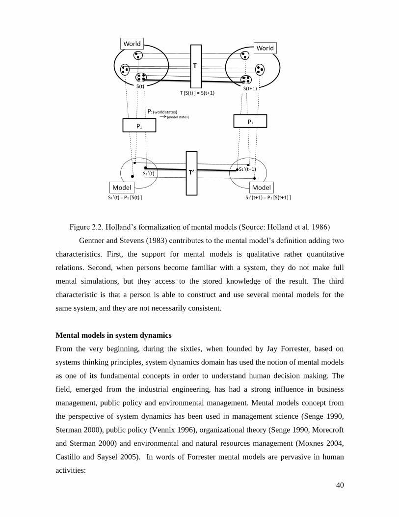
40
Figure 2.2. Holland’s formalization of mental models (Source: Holland et al. 1986)
Gentner and Stevens (1983) contributes to the mental model’s definition adding two
characteristics. First, the support for mental models is qualitative rather quantitative
relations. Second, when persons become familiar with a system, they do not make full
mental simulations, but they access to the stored knowledge of the result. The third
characteristic is that a person is able to construct and use several mental models for the
same system, and they are not necessarily consistent.
Mental models in system dynamics
From the very beginning, during the sixties, when founded by Jay Forrester, based on
systems thinking principles, system dynamics domain has used the notion of mental models
as one of its fundamental concepts in order to understand human decision making. The
field, emerged from the industrial engineering, has had a strong influence in business
management, public policy and environmental management. Mental models concept from
the perspective of system dynamics has been used in management science (Senge 1990,
Sterman 2000), public policy (Vennix 1996), organizational theory (Senge 1990, Morecroft
and Sterman 2000) and environmental and natural resources management (Moxnes 2004,
Castillo and Saysel 2005). In words of Forrester mental models are pervasive in human
activities:
T
S(t)
P1
T’
P1
S1’(t)S1’(t+1)
S(t+1)
WorldWorld
Model Model
S1’(t) = P1 [S(t) ] S1’(t+1) = P1 [S(t+1) ]
P: (world states) (model states)
T [S(t) ] = S(t+1)
41
“Each of us uses models constantly. Every person in private life and in business
instinctively uses models for decision making. The mental images in one’s head about
one’s surroundings are models. One’s head does not contain real families,
businesses, cities, governments, or countries. One uses selected concepts and
relationships to represent real systems. A mental image is a model. All decisions are
taken on the basis of models. All laws are passed on the basis of models. All executive
actions are taken on the basis of models. The question is not to use or ignore models.
The question is only a choice among alternative models.” (Forrester 1971. 4)
According Forrester:
“Mental models are fuzzy, incomplete, and imprecisely stated. Furthermore,
within a single individual, mental models change with time, even during the flow of a
single conversation. The human mind assembles a few relationships to fit the context
of a discussion. As debate shifts, so do the mental models. Even when only a single
topic is being discussed, each participant in a conversation employs a different
mental model to interpret the subject. Fundamental assumptions differ but are never
brought into the open.” (Forrester 1971. 4)
Peter Senge developed the mental models concept in his book “The fifth Discipline”
(1990) in the domain of organizational development and business management. He defines
a mental model as the image that people carry in their head about how the world works,
which could be simple generalizations or complex theories, and that the most important
propriety is that they determines people’s behavior. The issue about mental models is not
that they are right or wrong, the relevant question is that they are tacit and belongs to the
domain of unconscious mind. Emphasis is done in the fact that mental models can impede
or boost learning, as well as their key role in communication.
42
Doyle and Ford (1999) urges for a standardization of the concept for system
dynamics practice “A mental model of a dynamic system is a relatively enduring and
accessible, but limited, internal conceptual representation of an external system (historical,
existing or projected) whose structure is analogous to the perceived structure of that
system.” (414). But an operational definition is given by the same authors “A mental model
is a conceptual representation of a social problem that can be externalized in the form of a
causal loop diagram.” (414). In a study about public mental models about global warming
and green house effect Sterman and Sweeney (2007) give a definition that synthesizes
cognitive sciences and system dynamics approaches:
“Definitions of the term ‘mental model’ are many and varied, including domain
knowledge, typologies for categorizing experience, and heuristics for judgment and
decision making, among others (see, e.g., Axelrod 1976; Gentner, and Stevens 1983;
Johnson-Laird 1983; Morgan et al. 2002). As used here, the term ‘mental model’
includes a person’s (often implicit) beliefs about the networks of causes and effects
that describe how a system operates, along with the boundary of the model (which
factors are considered endogenous, exogenous, or immaterial) and the time horizon
considered relevant.” (Sterman and Sweeney 2007, 215).
The most common representation of mental models in system dynamics has been the
causal loop diagrams, which are based in the cognitive maps method developed by Axelrod
(1976). Other methods include hexagons (Hogdson 1994), flow diagrams and stock and
flow diagrams. The next section offers an overview of the role of mental models on the
learning process, conceived as the basic process for decision-making.
Collective mental models
Coping with complex systems such as SESs implies the use of mental models, but also it is
needed a way to capture information. Beratan (2007) identifies two processes that use
groups of people and individuals: filter and specialization. It is necessary to filter
strategically the huge quantity of information that comes from the environment, and to
integrated it into a predictive model. Mental models work as filter in this process. The
second ability is the specialization, which consists in
“the division of cognitive labor among a group of people” and it “serves as a
collective strategy for increasing the usefulness of the implicit and explicit predictive
models that form the cognitive basis for action…each individual’s sub model
43
contributes to a greater or lesser degree to a collective system model, expressed in
part as cultural norms and collective expectations. How well the sub-models are
integrated and coordinated is a significant factor determining the effectiveness of
collective decisions and actions. Integration and coordination occur primarily by
means of interpersonal interactions, and thus governance systems that provide
abundant opportunities for face-to-face interactions among both those making and
affected by decisions should be more effective over the long run, particularly in times
marked by change.” (Beratan 2007, 5)
According to North (2007), common institutional and educational structures create
beliefs and shared perceptions. Therefore, a common cultural patrimony entails a mean to
reduce divergent mental models among the members of a society, and it is the instrument
for the intergenerational transference of integrative perceptions. In fact authors such as
Louis and Sutton (1991 in Harris 1994) have defined cultures as “shared schemas”.
Risk, uncertainty and perception
It is important to define risk, uncertainty, and perception because they are fundamental
concepts to understand the relation between mental models, institutions and management of
socio-ecological systems. Human societies face permanent change in their environment and
inside themselves. This condition implies important levels of risk in individual and
collective decisions and a necessity to deal with uncertainty. In order to structure the
environment and have the possibility to preview possible outcomes of their actions, humans
build institutions, understood as the set of norms and rules that structure social interactions.
According to North (2007), human beings attempt to use their perceptions of the world to
structure their environment in order to reduce the uncertainty that embodies their
interactions. The institutions restrict and provide prescriptions to human interactions and
“the culture of a society is the cumulative structure of rules and norms (and beliefs)
inherited from the past which shape our present and influence our future” (North 2007).
Douglas North offers a clear conceptualization of these terms and their relations.
North (2007) complements the definitions of Frank Knight (1921) of risk and
uncertainty. The first, according to Knight, is a condition in which it is possible to infer a
probabilistic distribution of outcomes, with the aim to secure against it. Uncertainty is a
condition in which there is not probabilistic distribution of outcomes at all. Though this
definition of risk is a reduction to a probabilistic problem, it provides a solid base to the
44
problem. A more integral view states that humans have a pulse to make more predictable
their environment. Heiner (1983, in North 2007) specifies that there is a gap between the
agent’s competency and the difficulty of the decision problem, and humans, facing this gap,
will build rules to constrain the universe of options in such uncertainty situations. Beliefs
systems and institutions only make understood as a response to diverse levels of uncertainty
that humans face. Though the deep origin of institutions has been the human effort to
structure the environment in order to make it more predictable, this effort contributes in
many cases, to increase the uncertainty. The creation and adjusting of institutions that
caused the reduction in the physical environment generated a highly complex social
environment with a new set of uncertainties (North 2007).
A more comprehensive vision of uncertainty is given by North (2007,) by
establishing five degrees or types of uncertainty:
45
1. “Uncertainty that can be reduced by means of an information increase, given the
existent flow of knowledge.
2. Uncertainty that can be reduced by means of an increase in the flow of knowledge
in the existent institutional framework.
3. Uncertainty that only can be reduced by means of the modification of the
institutional framework.
4. Uncertainty in novel situations that entails a restructuration of beliefs.
5. Residual uncertainty that supplies the foundations of the “no rational” beliefs.”
As mentioned above, humans use mental models to reason and make predictions
about the environment; this is a way to deal with and reduce with uncertainty. One of the
sources of information for mental models is what individuals perceive from their
environment. Perception is vital to understand how humans acquire information about the
environment, but human perception is not perfect. If individuals were capable of perfect
perception, perhaps there would not be institutions needed, even facing uncertainty because
uncertainty is a function of knowledge (North 2007). The imperfect perception of an
individual is defined as an erroneous probabilistic distribution about risk states or the
attribution of probabilities to uncertainty states (North 2007). “In a word of imperfect
perception, uncertainty is a function of knowledge and institutions” (North 2007, my
translation). Individual and collective decisions are made in order to affect the environment
and solve problems, in turn; decisions are fed by mental models. Since human environment
is dynamic and characterized by uncertainty, as it has mentioned above, the resulting
effects of such decisions tend to be counterintuitive due to delays in the feedback from the
environment and its dynamics. This condition leads to inquiry about the construction of
mental models and how they are used to cope with such dynamic and uncertain
environment. Denzau and North (1994) point out that:
“ in order to understand decision making under such conditions of uncertainty we
must understand the relationship between the mental models that individuals
construct to make sense out of the world around them, the ideologies that evolve from
such constructions, and the institutions that develop in a society to order
interpersonal relationships.” (Denzau & North 1994)
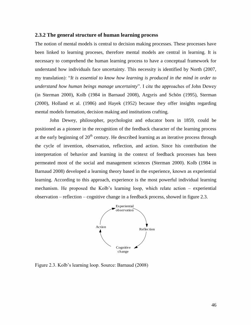
46
2.3.2 The general structure of human learning process
The notion of mental models is central to decision making processes. These processes have
been linked to learning proceses, therefore mental models are central in learning. It is
necessary to comprehend the human learning process to have a conceptual framework for
understand how individuals face uncertainty. This necessity is identified by North (2007,
my translation): “It is essential to know how learning is produced in the mind in order to
understand how human beings manage uncertainty”. I cite the approaches of John Dewey
(in Sterman 2000), Kolb (1984 in Barnaud 2008), Argyris and Schön (1995), Sterman
(2000), Holland et al. (1986) and Hayek (1952) because they offer insights regarding
mental models formation, decision making and institutions crafting.
John Dewey, philosopher, psychologist and educator born in 1859, could be
positioned as a pioneer in the recognition of the feedback character of the learning process
at the early beginning of 20th
century. He described learning as an iterative process through
the cycle of invention, observation, reflection, and action. Since his contribution the
interpretation of behavior and learning in the context of feedback processes has been
permeated most of the social and management sciences (Sterman 2000). Kolb (1984 in
Barnaud 2008) developed a learning theory based in the experience, known as experiential
learning. According to this approach, experience is the most powerful individual learning
mechanism. He proposed the Kolb’s learning loop, which relate action – experiential
observation – reflection – cognitive change in a feedback process, showed in figure 2.3.
Figure 2.3. Kolb’s learning loop. Source: Barnaud (2008)
Reflec tion
Experiential
observation
Action
Cognitive
change
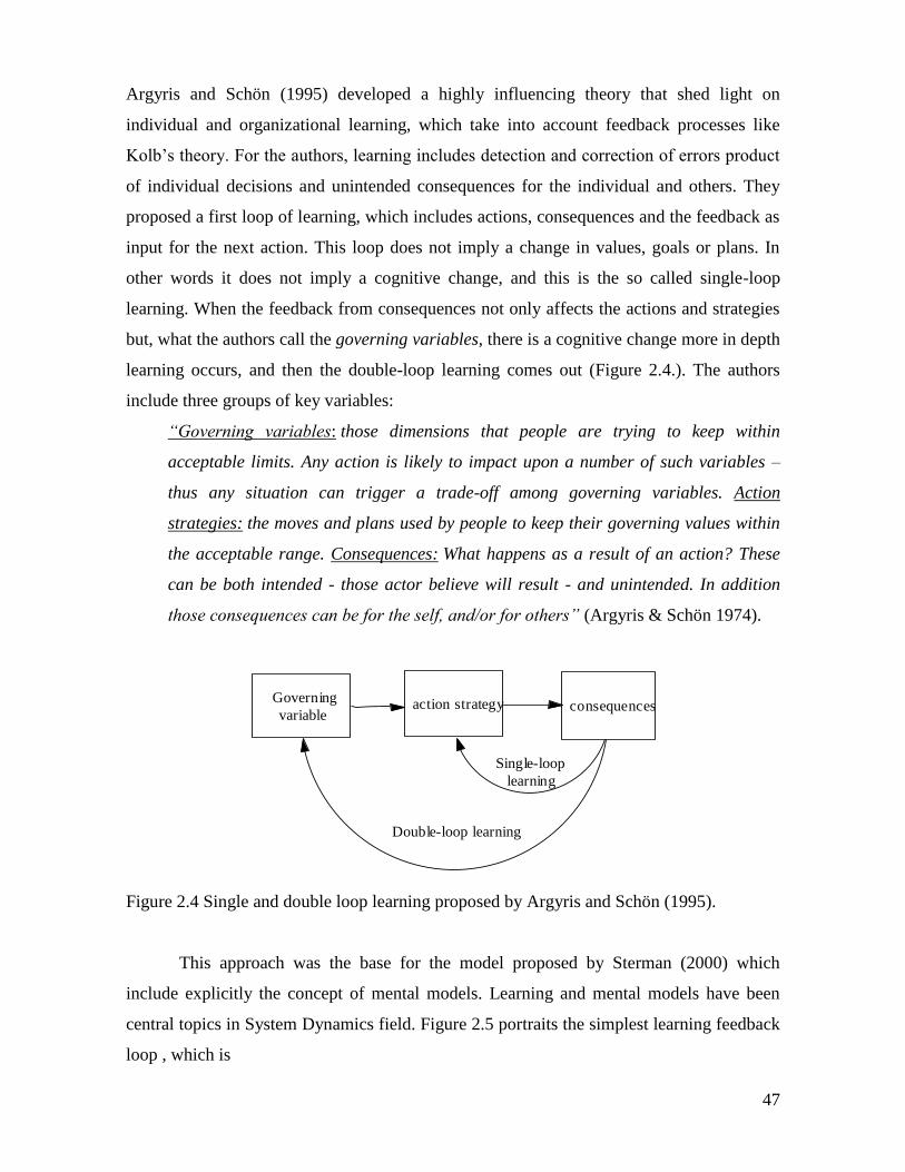
47
Argyris and Schön (1995) developed a highly influencing theory that shed light on
individual and organizational learning, which take into account feedback processes like
Kolb’s theory. For the authors, learning includes detection and correction of errors product
of individual decisions and unintended consequences for the individual and others. They
proposed a first loop of learning, which includes actions, consequences and the feedback as
input for the next action. This loop does not imply a change in values, goals or plans. In
other words it does not imply a cognitive change, and this is the so called single-loop
learning. When the feedback from consequences not only affects the actions and strategies
but, what the authors call the governing variables, there is a cognitive change more in depth
learning occurs, and then the double-loop learning comes out (Figure 2.4.). The authors
include three groups of key variables:
“Governing variables: those dimensions that people are trying to keep within
acceptable limits. Any action is likely to impact upon a number of such variables –
thus any situation can trigger a trade-off among governing variables. Action
strategies: the moves and plans used by people to keep their governing values within
the acceptable range. Consequences: What happens as a result of an action? These
can be both intended - those actor believe will result - and unintended. In addition
those consequences can be for the self, and/or for others” (Argyris & Schön 1974).
Figure 2.4 Single and double loop learning proposed by Argyris and Schön (1995).
This approach was the base for the model proposed by Sterman (2000) which
include explicitly the concept of mental models. Learning and mental models have been
central topics in System Dynamics field. Figure 2.5 portraits the simplest learning feedback
loop , which is
Governing
variableaction strategy consequences
Double-loop learning
Single-loop
learning
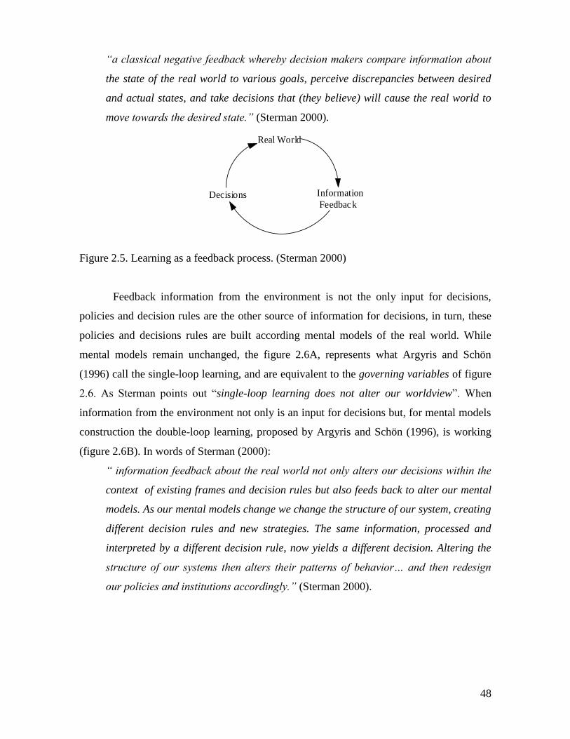
48
“a classical negative feedback whereby decision makers compare information about
the state of the real world to various goals, perceive discrepancies between desired
and actual states, and take decisions that (they believe) will cause the real world to
move towards the desired state.” (Sterman 2000).
Figure 2.5. Learning as a feedback process. (Sterman 2000)
Feedback information from the environment is not the only input for decisions,
policies and decision rules are the other source of information for decisions, in turn, these
policies and decisions rules are built according mental models of the real world. While
mental models remain unchanged, the figure 2.6A, represents what Argyris and Schön
(1996) call the single-loop learning, and are equivalent to the governing variables of figure
2.6. As Sterman points out “single-loop learning does not alter our worldview”. When
information from the environment not only is an input for decisions but, for mental models
construction the double-loop learning, proposed by Argyris and Schön (1996), is working
(figure 2.6B). In words of Sterman (2000):
“ information feedback about the real world not only alters our decisions within the
context of existing frames and decision rules but also feeds back to alter our mental
models. As our mental models change we change the structure of our system, creating
different decision rules and new strategies. The same information, processed and
interpreted by a different decision rule, now yields a different decision. Altering the
structure of our systems then alters their patterns of behavior… and then redesign
our policies and institutions accordingly.” (Sterman 2000).
Information
Feedback
Real World
Decisions
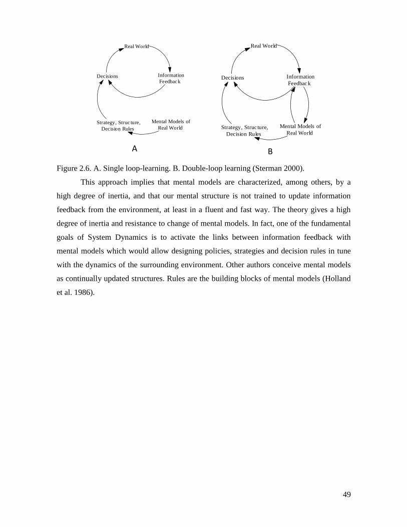
49
Figure 2.6. A. Single loop-learning. B. Double-loop learning (Sterman 2000).
This approach implies that mental models are characterized, among others, by a
high degree of inertia, and that our mental structure is not trained to update information
feedback from the environment, at least in a fluent and fast way. The theory gives a high
degree of inertia and resistance to change of mental models. In fact, one of the fundamental
goals of System Dynamics is to activate the links between information feedback with
mental models which would allow designing policies, strategies and decision rules in tune
with the dynamics of the surrounding environment. Other authors conceive mental models
as continually updated structures. Rules are the building blocks of mental models (Holland
et al. 1986).
Information
Feedback
Real World
Decisions
Strategy, Struc ture,
Decision Rules
Mental Models of
Real World
Information
Feedback
Real World
Decisions
Strategy, Struc ture,
Decision Rules
Mental Models of
Real World
A B
50
“Learning entails developing a structure by which to interpret the varied signals
received by the senses. The initial architecture of the structure is genetic, but the
subsequent scaffolding is a result of the experiences of the individual. The
experiences can be classified into two kinds-those from the physical environment and
those from the socio-cultural linguistic environment. The structures consist of
categories-classifications that gradually evolve from earliest childhood to organize
our perceptions and keep track of our memory of analytic results and experiences.
Building on these classifications, we form mental models to explain and interpret the
environment-typically in ways relevant to some goal. Both the categories and the
mental models will evolve, reflecting the feedback derived from new experiences:
feedback that sometimes strengthens our initial categories and models or may lead-to
modifications-in short, learning. Thus the mental models may be continually
redefined with new experiences, including contact with others' ideas.” (North 1994,
362 -363)
The previous paragraphs have given an overview of decision making as a learning
process in which mental models are central. The next section explains the more relevant
aspects of cognitive processes for understanding the role of mental models in human
cognition.
51
2.3.3 Cognitive processes
Theories about brain functioning are relevant for the understanding of mental models
formation. Neuroscience researchers have reach a consensus about a connectionist model of
brain functioning. In this model, neuronal networks gain experience through the
modification of its connection patterns after repeated expositions to the environment. In
essence, such networks, form impressions in the same way that an astronomic photography
with a long exposition time when it collect passively data trough time. Several expositions
to a situation or an object allow neuronal networks to extract regularities from the
environment, and these regularities are stored in stable connection patterns (Donald 2001,
in North 2007). According this model it is possible to say that the brain works according a
reasoning based on patterns, which are essential to explain decisions in an uncertainty
world. According to North (2007), this way of brain functioning has several consequences
for human cognitive processing. Firstly, humans are efficient in understanding if the
situation is highly similar to other past events occurred in our experience. Secondly, it is
difficult to include into one’s culture strange mindsets, not grounded in the norms
developed in one’s own culture. Thirdly, people perceive, remember and understand
through pattern comparison. This is the key of our ability to generalize and to use
analogies. Such capability allows people, not only to model the world, but also to build
theories in order to face uncertainty. And fourthly, the discovering of patterns where they
do not exist is coherent with the pervasive human effort for make theories or dogma to
explain the world even when there are no scientific explanations. Therefore mental models
are built, based on patterns and regularities in order to explain and predict.
The study of human cognitive processes, that is, the way in which “the human brain
absorbs information, recognizes and frames problematic situations, and causes appropriate
responses” (Beratan 2007, 2), has still a significant gap between the knowledge about the
biology of the brain and the outcomes or products of brain activity, such as memory and
decision making. In spite of such gap, the current knowledge offers enough elements for
interpreting and explaining individual and collective behavior. There is consensus about the
biological fundaments of thinking and memory, which are neuronal circuits arranged in
neuronal patterns of connections. Experience entails the activation of neuronal networks,
and thinking processes consist of dynamic of pattern connections of neurons (Beratan
2007).
52
Neuroscience researchers have identified two mechanisms of memory, which help
to link mental models building and behavior of persons. These are implicit and explicit
memory. The first implies forms of memory marked by emotions, behavior, perceptions
and body or somatosensorial aspects (Siegel 2001). The second, explicit memory is
activated by slow learning of regularities from repeated experiences (Smith & DeCoster,
2000). “Both type of memories are stored as patterns of neural connections; whenever one
part of the pattern is activated (by sensory input, for instance) activation spreads through
the whole interconnected set of neurons. These connections are strengthened with use.”
(Beratan 2007. p. 3). The link between mind and memory, and individual decision making
have been represented by a “dual process model” (Chaiken & Trope 1999) of cognition.
This model involves two parallel process of reasoning: nonconscious and conscious
processing forms. Nonconscious mode utilizes implicit memory, and is automatic, “and
thus contextualizes the current situation in light of background beliefs and knowledge that
reflect the learning history of the individual” (Evans et al. 2003). Decisions made in this
mode are based on the assumption that the outcomes of a given decision are going to be
similar to the ones in similar situations in the past. The processes that belong to the
consciousness domain are actions of which the individual is aware, and they are effort
demanding and susceptible of control. This processing allows persons to cope with novelty
and figure out new strategies for dealing with problems in the long run. (Beratan 2007).
A common description of a decision making process is when individual engages in a
deliberation process among several possibilities. If the situation is like past ones, the
nonconscious mind tests the situation against saved past ones, and chooses an option that
has worked in the past. But if there are no coincidences with saved patterns, the mind starts
to test hypothesis for different options. Then, the outcome of the process is saved as
experiential knowledge for future use by the nonconscious mind (Beratan 2007).
53
Current neuroscience research has found that this is not the functioning of the
cognitive basis of behavior; instead there are non-linear processes of emergence (Beratan
2007). The mechanisms can be described as follows: First of all, a pattern of neurons
representing the desired outcome is activated. Second, this pattern interacts with other
patterns that represent perceptions of current conditions triggering “a cascade of neural
activity, shaped by connections formed through past experience” (Beratan 2007 p. 4).
Third, a new pattern emerges that guides the actions. This process emerges from non
conscious cognitive processing. And, very important is the fact that the conscious
processing comes up when the individual is asked to explain decisions or actions. In this
point a logical rationale for the decision made is constructed (Beratan 2007).
But the brain keeps a high number of “potentially relevant stored patterns formed
as a result of past experience” (Beratan 2007, 4). The way persons react to specific
situations depends on which neural pattern is activated. Neuronal pattern activation belongs
to the domain of non conscious process. Patterns are activated by any sensory input,
“contingency has a strong impact on the emergent pattern” (Beratan 2007. p. 4). If this
explanation of behavior generation is plausible, then “It is likely that many “heuristics”,
rather than being logical decision rules (even “boundedly rationale” ones), are actually
patterns of neural connections that retain a record of general regularities encountered
through experience” (Beratan 2007, 4).
The following section reviews the importance and use of the mental model notion in
governance of SESs.
54
2.3.4 Mental models and governance of SESs
The concept of mental models have been studied in natural resource management by
Moxnes (1998, 1998b, 2004) in the study of reindeer and fisheries decision making and
management in Norway, Sterman (2002, 2007) in the study of public understanding of
global warming process, Becu (2006) in a research about the local management of
watersheds in the north of Thailand, Abel et al. (1998) studying the role of mental models
in communication among researchers, extension officers and pastoralists about resources
management and ecosystem’s functioning in Australian rangelands. Denzau and North
(1994) also stresses the importance of communication in order to build collective shared
mental models. Bigss et al. (2008) reports the results of the study carried out as a
consequence of the discussion in the Resilience Alliance meeting of 2006 about the effect
of different stakeholders’ mental models have, on natural resource use and management,
and on resilience of social-ecological systems. The project was conducted in South Africa,
aiming to illustrate a practical example the importance and relevant methods for
understanding mental models. Mathevet et al. (2011) stressed the importance of mental
models in water management in Camarge biosphere reserve in the south of France. Stone-
Stone-Jovicich et al. (2011) applies consensus analysis, an anthropological method to asses
mental models of stakeholders about water management in a watershed in the South Africa.
Etienne et al. (2011) presented the ARDI method, developed in collaboration with Green
researchers of CIRAD in France, to construct representations of stakeholders’ mental
models of SESs. Du Toit et al. (2011) used mental models for negotiation processes in
water management in South Africa. And, Jones et al. (2011) carried out a complete review
of the concept in relation to natural resources management.
Denzau and North (1994) and North (2007) have stressed the link between mental
models and cognitive processes and institutions. Individuals design rules as a way to
structure the surrounding environment; in turn the cognitive systems of individuals create
mental models, which are representations of the external environment with the objective to
interpret it. The human environment is a construct of rules, norms, conventions and forms
of doing things that define the human interaction framework (North 2007). Therefore, the
way in which individuals and human groups interact with ecosystems necessarily have to
do with rules and mental models. In this sense Ostrom (2005) extends this relation to
common pool resources, she uses an adapted version of the framework proposed by Denzau
and North (2000), to explain the relationships between information, decisions and mental
55
models, for explaining the central aspects of institutional analysis regarding individual and
collective information processing in institutional dynamics. The multitier framework,
developed by Ostrom (2007, 2009), aiming to link the local context and institutional and
policy design in SESs, includes mental models as one of the key variables to be understood
for sound governing of SESs. This proposal is called the sustainability framework, which
will be presented in the section 2.5 of this chapter. In the next section I present a revision of
the concepts of institution and the analytical framework for its analysis in the context of
SESs
2.4. Institutional Analysis and Development (IAD) framework
The approach adopted for this research is the one developed in the New Institutional
Economics, which origins are usually attributed to Coase (1937). It is from 70s that the
field started to call the general attention, and from 1991, when Coase won the Nobel Prize,
followed by Becker (1992) and North (1993), the field reached its maturity. The approach
was positioned as the studies of a group of economists and science policy scholars
concerned about the relation between institutions and individual behaviour, as well as the
form in which such institutions shape productive and exchange activities (Hauditier 2007).
But it is until 2009, that the attention is given on the development of the neo institutional
approach in the field of natural resource management and concretely in common pool
resources governance, with the awarding of the Nobel Prize to Elinor Ostrom.
In brief, according Acheson (2006) the neoclassical economics conceives
individuals as rational agents that perceive perfectly the environment. It is assumed that
knowledge of goods is enough to make decisions in the competitive markets exchange.
Institutions are not considered to have an important influence in markets and decisions, or
they constitute obstacles and constraints to the invisible hand of the economy. In turn;
scholars belonging to the new institutional economics stream assume that individuals have
bounded rationality and that information acquisition has high costs. Assumptions include
also that individuals exhibit opportunistic behaviour, and different moral systems. It is
assumed that institutions are the result of political processes, and that they affect the
behaviour of individuals, and that they have an important influence on markets efficiency
and wealth generation. In line with these contributions, Acheson (2006) defines a research
program of five main topics for the new institutional economics: 1) Institutions, property
56
rights and their effects on economic performance, 2) the conditions for collective action, 3)
the relation between rules and real interactions among actors, 4) the development of
different types of firms and markets in capitalists societies, and 5) explanation of
institutional development through time.
The Institutional Analysis and Development (IAD) (Ostrom et al. 1994, Ostrom
2005) is one of the academic developments inside the New Institutional Economics that has
been used to study the problem of CPR management. In this section I, first, give the
definition of institutions according the mentioned school, and then develop the aspects of
the IAD framework that will be used and discussed in this study.
2.4.1 Definition of institutions
In line with authors such as North (1990), Ostrom (2005) and Janssen (2002) humans
design rules in order to relate with the environment and these institutions are designed
according perspectives of the world. North defines institutions in this way:
“The institutions are the rules of the game in a society or, more formally, they are
the constraints created by people that shape human interaction. Therefore, they
structure incentives in human exchange, political, social or economic. Institutional
change is the way in which societies evolve through time; hence it is the key for
understanding the historical change.” (North 1990, 13, my translation)
Institutions define and constrain individuals’ decision making, and have an important
characteristic which is that the enforcement, monitoring and sanctions are costly not only in
monetary terms, but in social terms. To know human organizations means to analyse
governance structures, institutions, capabilities and learning, which will determine the
success of the organization. The principal function of institutions is to reduce uncertainty
creating a more stable structure, which does not mean an unchanged structure, in fact they
are in permanent change (North 1990).
For Ostrom the set of rules and norms that people use to relate themselves with the
ecosystems constitute the institutions which are defined as “the prescriptions that humans
use to organize all repetitive and structured interactions ... at all scales. Individuals
interacting within rule-structured situations face choices regarding the actions and
strategies they take, leading to consequences for themselves and for others.” (Ostrom 2005,
3). Janssen (2002) points out that
57
“Institutions are made up of formal and informal constraints. Formal constraints
are rules, laws, and constitutions. Informal constraints are norms of behavior.
Institutions often react to surprises by adding additional rules to repair external
effects. New rules can be added in a relatively brief time, but changing or removing
rules is usually a slow process.”
Davidson-Hunt and Berkes (2003) remark that the set of rules, which form an institution is
a fundamental link between social and ecological systems. Institutions are a construct that
evolves along with social collectives and, in the case of the relation with ecosystems, they
may or may not evolve with them. Rules and norms are part of the strategies that society
develops for adapting to change. As Ostrom (2005) states “Rules can be thought of as the
set of instructions for creating an action situation in a particular environment […]Rules
combine to build the structure of an action situation”.
It is important to establish the differences between rules, norms and strategies.
Ostrom (2006, 2) defines the terms in this manner: rules are “shared prescriptions (must,
must not, or may) that are mutually understood and predictably enforced in particular
situations by agents responsible for monitoring conduct and imposing sanctions”. Norms
are “shared prescriptions that tend to be enforced by the participants themselves through
internally and externally imposed costs and inducements.” And strategies are “regularized
plans that individuals make within the structure of incentives produced by rules, norms and
expectations of the likely behavior of others”
Rules in use are the things that people do and the ones that don’t, which are learnt in
everyday life, and that may be contradictory with rules written in formal documents
(Ostrom 2006). The rules in use could include rules, as defined above, and norms.
2.4.2. The Institutional Analysis and Development Framework (IAD)
The IAD framework is aiming to guide the analysis. It helps to identify variables and
relationships needed to carry out the study and evaluation of institutional arrangements.
The framework constitutes a meta theoretical language for comparing theories. In this way
the framework contribute to pose relevant questions according to each case (Ostrom 2006).
The usefulness of a guiding framework is that different theories can be used depending on
the type of problem and specific context. At broader scale it is possible to start the
description of the framework by a central element, which will be discussed in detail below;
the action arena. Figure 2.7 illustrates the general framework. The action arena depends on
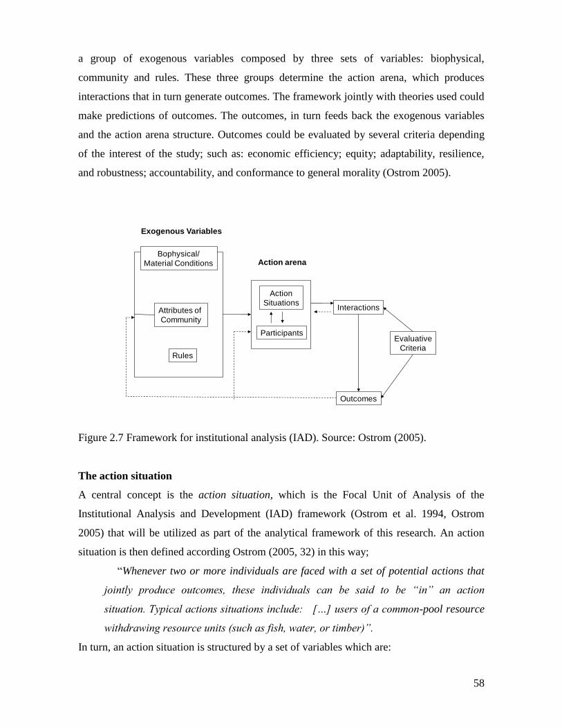
58
a group of exogenous variables composed by three sets of variables: biophysical,
community and rules. These three groups determine the action arena, which produces
interactions that in turn generate outcomes. The framework jointly with theories used could
make predictions of outcomes. The outcomes, in turn feeds back the exogenous variables
and the action arena structure. Outcomes could be evaluated by several criteria depending
of the interest of the study; such as: economic efficiency; equity; adaptability, resilience,
and robustness; accountability, and conformance to general morality (Ostrom 2005).
Figure 2.7 Framework for institutional analysis (IAD). Source: Ostrom (2005).
The action situation
A central concept is the action situation, which is the Focal Unit of Analysis of the
Institutional Analysis and Development (IAD) framework (Ostrom et al. 1994, Ostrom
2005) that will be utilized as part of the analytical framework of this research. An action
situation is then defined according Ostrom (2005, 32) in this way;
“Whenever two or more individuals are faced with a set of potential actions that
jointly produce outcomes, these individuals can be said to be “in” an action
situation. Typical actions situations include: […] users of a common-pool resource
withdrawing resource units (such as fish, water, or timber)”.
In turn, an action situation is structured by a set of variables which are:
Attributes of
Community
Rules
Action
Situations
Participants
Interactions
Outcomes
Evaluative
Criteria
Bophysical/
Material Conditions Action arena
Exogenous Variables
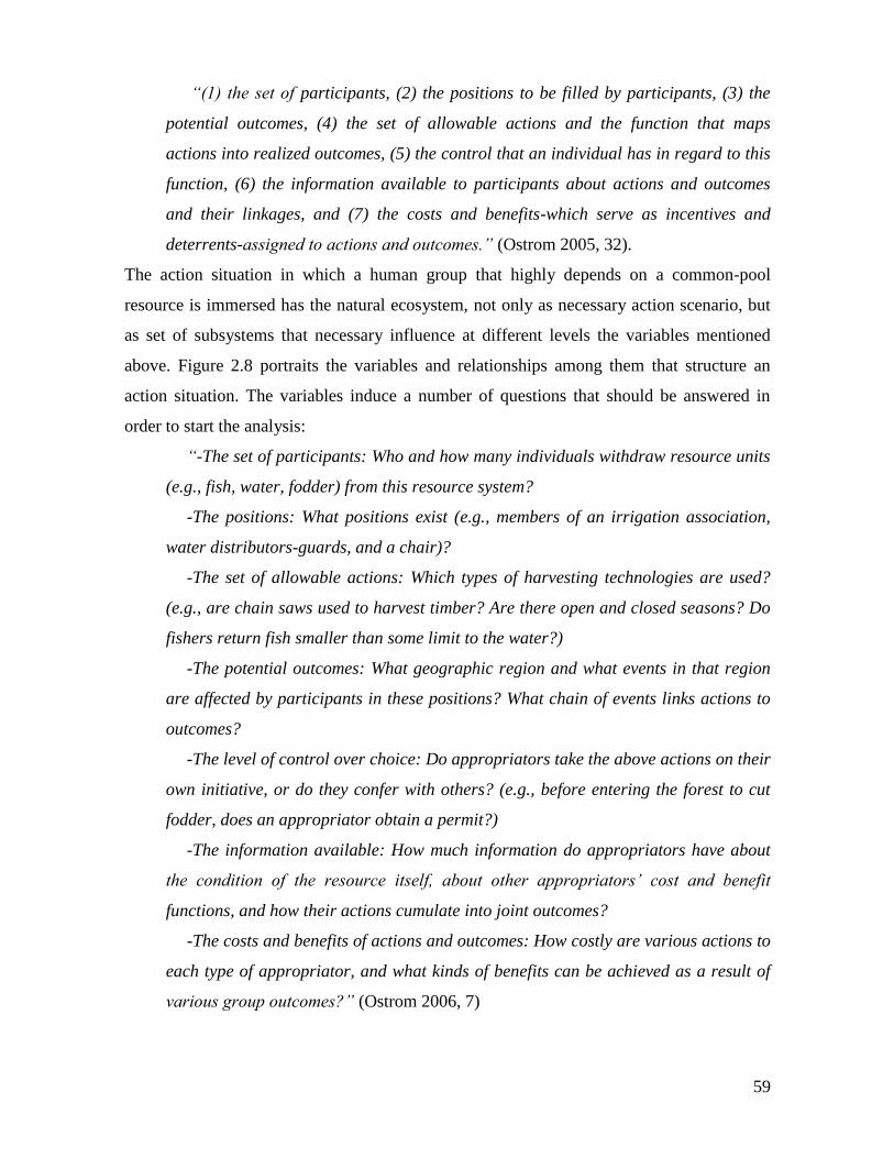
59
“(1) the set of participants, (2) the positions to be filled by participants, (3) the
potential outcomes, (4) the set of allowable actions and the function that maps
actions into realized outcomes, (5) the control that an individual has in regard to this
function, (6) the information available to participants about actions and outcomes
and their linkages, and (7) the costs and benefits-which serve as incentives and
deterrents-assigned to actions and outcomes.” (Ostrom 2005, 32).
The action situation in which a human group that highly depends on a common-pool
resource is immersed has the natural ecosystem, not only as necessary action scenario, but
as set of subsystems that necessary influence at different levels the variables mentioned
above. Figure 2.8 portraits the variables and relationships among them that structure an
action situation. The variables induce a number of questions that should be answered in
order to start the analysis:
“-The set of participants: Who and how many individuals withdraw resource units
(e.g., fish, water, fodder) from this resource system?
-The positions: What positions exist (e.g., members of an irrigation association,
water distributors-guards, and a chair)?
-The set of allowable actions: Which types of harvesting technologies are used?
(e.g., are chain saws used to harvest timber? Are there open and closed seasons? Do
fishers return fish smaller than some limit to the water?)
-The potential outcomes: What geographic region and what events in that region
are affected by participants in these positions? What chain of events links actions to
outcomes?
-The level of control over choice: Do appropriators take the above actions on their
own initiative, or do they confer with others? (e.g., before entering the forest to cut
fodder, does an appropriator obtain a permit?)
-The information available: How much information do appropriators have about
the condition of the resource itself, about other appropriators’ cost and benefit
functions, and how their actions cumulate into joint outcomes?
-The costs and benefits of actions and outcomes: How costly are various actions to
each type of appropriator, and what kinds of benefits can be achieved as a result of
various group outcomes?” (Ostrom 2006, 7)
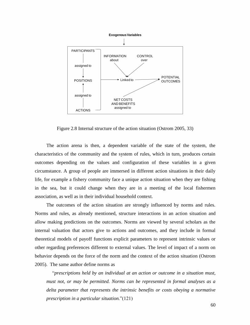
60
Figure 2.8 Internal structure of the action situation (Ostrom 2005, 33)
The action arena is then, a dependent variable of the state of the system, the
characteristics of the community and the system of rules, which in turn, produces certain
outcomes depending on the values and configuration of these variables in a given
circumstance. A group of people are immersed in different action situations in their daily
life, for example a fishery community face a unique action situation when they are fishing
in the sea, but it could change when they are in a meeting of the local fishermen
association, as well as in their individual household context.
The outcomes of the action situation are strongly influenced by norms and rules.
Norms and rules, as already mentioned, structure interactions in an action situation and
allow making predictions on the outcomes. Norms are viewed by several scholars as the
internal valuation that actors give to actions and outcomes, and they include in formal
theoretical models of payoff functions explicit parameters to represent intrinsic values or
other regarding preferences different to external values. The level of impact of a norm on
behavior depends on the force of the norm and the context of the action situation (Ostrom
2005). The same author define norms as
“prescriptions held by an individual at an action or outcome in a situation must,
must not, or may be permitted. Norms can be represented in formal analyses as a
delta parameter that represents the intrinsic benefits or costs obeying a normative
prescription in a particular situation.”(121)
Exogenous Variables
PARTICIPANTS
Linked to
assigned to
POTENTIAL
OUTCOMESPOSITIONS
about
INFORMATION
over
CONTROL
ACTIONS
assigned to
NET COSTS
AND BENEFITSassigned to
61
In this way, one can consider formalization of the payoff function for the traditional
Homo economicus as being the internal and external values of actions and actions equal,
therefore it would not have a parameter representing a social norm of reciprocity for
example (Ostrom 2005). But in real action situations generated in commons local dilemmas
it is needed to recognize the heterogeneity of actors. Not only that some actors are
representative of the Homo economicus and others are strong reciprocators and other types
behavior, but that a individual can be a mix of several types of behavior in different action
situations. Of course the consequences for institutional analysis are important, as (Camerer
2003) explains it “Institutional arrangements can be understood as responding to a world
in which there are some sociopaths and some saints, but mostly regular folks who are
capable of both kinds of behavior” .
Crawford and Ostrom (1995) developed what was called a grammar of institutions,
which has been presented as integral part of the IAD in Ostrom (2005) and included as one
of the elements to build a complexity theory for sustainability by Norberg et al. (2008).
This approach contributes to clearly define norms, rules and strategies through an
institutional grammar (ADICO). A set of general actions to classifiy the actions is defined:
“A-Attributes of the person(s) involved,
D-wether a Deontic operator-a must, must not, or may-is involved,
I-the aIm of an action,
C-the Conditions involved, and
O-wether or not there is an Or else-a punishment.”
(Norberg et al. 2008, 59)
Therefore, a strategy is of the type AIC, and describes what actors try to achieve
(aim or purpose). A norm includes ADIC, and it is formed by adding a deontic principle and
a condition, and a rule is formed by ADICO, what means that the rule includes a
consequence for not following the rule. If the description of strategies, norms and rules are
written consistently in this way it is easier to compare institutions in diverse settings,
providing a useful tool for analyze institutional evolution (Ostrom 2005).
For understanding the role of rules in the outcomes of the action arena I use the ADICO
grammar of rules (Ostrom 2005). Analyzing rules by looking at their building blocks helps
to characterize the institutional statements and define what role they are playing in the
action arena as rules, norms or shared strategies. This analysis is done "to discover the
62
linguistic statements that form the institutional basis for shared expectations and potentially
for the observed regularity in behavior. Essentially, this entails discovering which of the
components exist in these statements and the contents of those components" (Ostrom 2005:
171). The components that form the ADICO are: Attributes, Deontic, Aim, Conditions and
Or else. According to the content of an institutional statement a rule has the five (ADICO)
components, a norm has four (ADIC) and a shared strategy has three (AIC). For example, a
prescription for extracting timber from a forest could be:
In order to guarantee the replacement rate of the forest, users from a given community
cannot harvest trees with trunks of a diameter less that 20 cm, if a logger is caught cutting
trees of minor diameter, she must pay a fine.
The Attribute component of the prescription is all the individuals of the community
that use the forest. The Deontic component is that users cannot harvest trees with trunks of
a diameter less that 20 cm. The Aim component would be: In order to guarantee the
replacement rate of the forest. The Conditions in this statement are not explicit but,
indirectly they are present; the statement applies for the forest used by this community,
meaning the area where the statement applies. The Conditions also include the time in
which the prescription applies, in this example, since it is not explicit; the temporal default
condition is all the time. The Or else condition in the example is: if a logger is caught
cutting trees of minor diameter, she must pay a fine.
This system can be use also to do a classification of rules, which is fundamental to
understand the way in which institutional arrangements affect an action situation. In order
to understand the rules in use I use the AIM rules classification approach, which consists in
the classification according the AIM of the rules. The AIM element of a rule is the "specific
description of a working part in an action situation to which an institutional statement
refers" (Ostrom 2005: 148). Classifying rules through this sorting mechanism allows
studying generative and regulatory rules, and also is useful for the three levels of the IAD
framework (Ostrom 2005). Seeing rules through the AIM element it is possible to classify
them in seven types according to their influence on the action situation. These categories
are: position, boundary, choice, aggregation, information, payoff and scope rules. They are
explained below.
63
Position rules affect the number of participants in a position. This includes the lower
and upper limits or the absence of limits.
Boundary rules prescribe who are the participants and how to enter and exit the
action situation. These types of rules specify: who is eligible to enter a position, the process
that determines which eligible participants may enter (or must enter) positions and how an
individual may leave (or must leave) a position.
Choice rules regulate the actions that each participant can carry out according to a
given position. They specify the required, allowed and forbidden actions, "by widening or
narrowing the range of actions assigned to participants, choice rules affect the basic rights,
duties, liberties, and exposures of members and the relative distribution of these to all."
(Ostrom 2005: 201). In synthesis, these types of rules distribute the power among
participants in a given action situation.
Aggregation rules aim to solve the problem of how to decide what participant in
which position has to act.
Information rules intend to regulate the information available to participants in the
action arena; they define channels of information and the possibilities of communication
among participants. These rules are relevant to inform about past actions of participants.
Information rules can define the channels of information flow, the frequency and accuracy
of communication, the subjects of communication and the official language.
Payoff rules assign rewards or sanctions to given actions by paying or receiving
something of value. Therefore these types of rules affect the costs and benefits of the action
situation. Scope rules define the number of the state variables affected; they influence the
outcomes of an action situation. In fact the objective (AIM) of these rules describes an
outcome rather than an action.
A general classification includes Position, Boundary, Choice, Aggregation,
Information, Payoff, and Scope rules. Figure 2.10 illustrates which variables affect each
type of rule.
In the context of SESs institutional arrangements pose a big challenge in terms of
SES’s governance. Since ecosystems are not stable Holling and Gunderson (2002) and
environmental change needs to be faced, institutional arrangements are to be designed
accordingly. Diversity and complexity in ecosystems and the society is pervasive,
consequently institutions must function in the same language. The above approach offers a
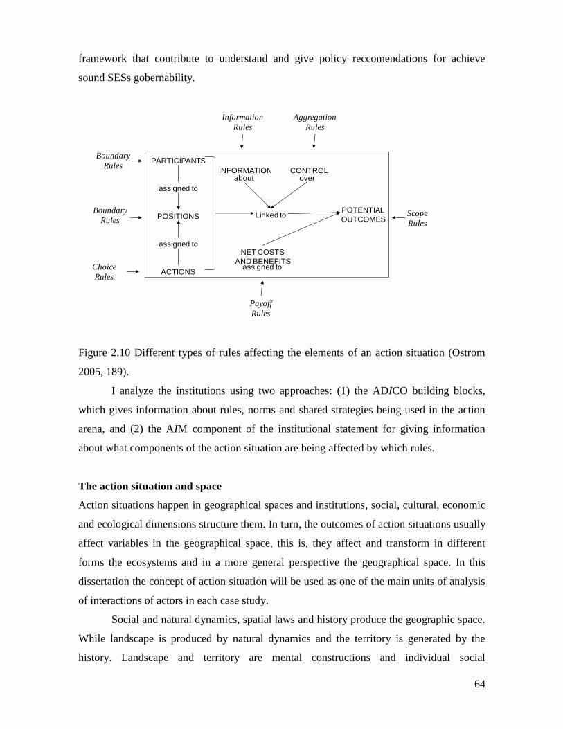
64
framework that contribute to understand and give policy reccomendations for achieve
sound SESs gobernability.
Figure 2.10 Different types of rules affecting the elements of an action situation (Ostrom
2005, 189).
I analyze the institutions using two approaches: (1) the ADICO building blocks,
which gives information about rules, norms and shared strategies being used in the action
arena, and (2) the AIM component of the institutional statement for giving information
about what components of the action situation are being affected by which rules.
The action situation and space
Action situations happen in geographical spaces and institutions, social, cultural, economic
and ecological dimensions structure them. In turn, the outcomes of action situations usually
affect variables in the geographical space, this is, they affect and transform in different
forms the ecosystems and in a more general perspective the geographical space. In this
dissertation the concept of action situation will be used as one of the main units of analysis
of interactions of actors in each case study.
Social and natural dynamics, spatial laws and history produce the geographic space.
While landscape is produced by natural dynamics and the territory is generated by the
history. Landscape and territory are mental constructions and individual social
PARTICIPANTS
Linked to
assigned to
POTENTIAL
OUTCOMESPOSITIONS
aboutINFORMATION
overCONTROL
ACTIONS
assigned to
NET COSTS
AND BENEFITSassigned to
Information
Rules
Aggregation
Rules
Boundary
Rules
Boundary
Rules
Choice
Rules
Payoff
Rules
Scope
Rules
65
representations (Brunet, 1990). The space generates the territory, which is the result of an
action carried out by an actor who exerts power in order to own a space, this is; the actor
territorializes the space (Raffestin, 1980). The territory is the place including actors and
their attributes (Laurin et al. 2001). The territory is defined by Debarbieux (1995) as the
product of the agency of material and symbolic resources that structure the practical
conditions of individual and collective existence. This agency process feeds back this
social group and the individuals about their identities. Therefore, the territory has a double
dimension: material and ideal. As a consequence the territory is a form of appropriation of
the space. The territory is also spatial configuration, which entails the definition of a
bounded unique entity where different actors exert the power. This spatial configuration is
the place where the interaction among different scales converges. Is in this sense that the
territory becomes a spatial form of the society (Retaillé, 1997). Hence, the territory stays
open, and adapts to every spatial combination that emerges from human interactions, in
terrestrial surface and individual experience (Di Meo, 2001). Territory becomes then a
concept completely plastic open to contemporaries mutations. The territory is a social
construct that mediates social relations, and its existence is possible thanks to a tacit or
explicit agreement, imposed or consented, among the members of a community. In addition
to that, the territory carries the values of the social group that lives in, and allows the
development of an individual and collective identity (Velasco-Graciet, 2006).
The action situation and mental models
Actors immersed in an action situation make decisions according to the internal variables of
the action situation itself, the external set of variables, and the previous outcomes.
Therefore, in order to understand and have predictive elements for different types of
outcomes it is necessary to have assumptions about components of human behavior. A
useful starting theory is constituted by the assumptions of rational choice theory that
establishes three elements. The first, is about information utilization, and includes its
acquisition, processing, representation and storing. The second element is the question of
the valuation that actors in an action situation give to the action and outcomes. And third,
the ways in which actors have to choose strategies having into account the resources
available (Ostrom 2005). Many assumptions could be made for each of these elements, as
well as numerous theories give different assumptions about each one. Ostrom (2005)
recommends focusing in one of the elements at a time regarding the assumptions to adopt.
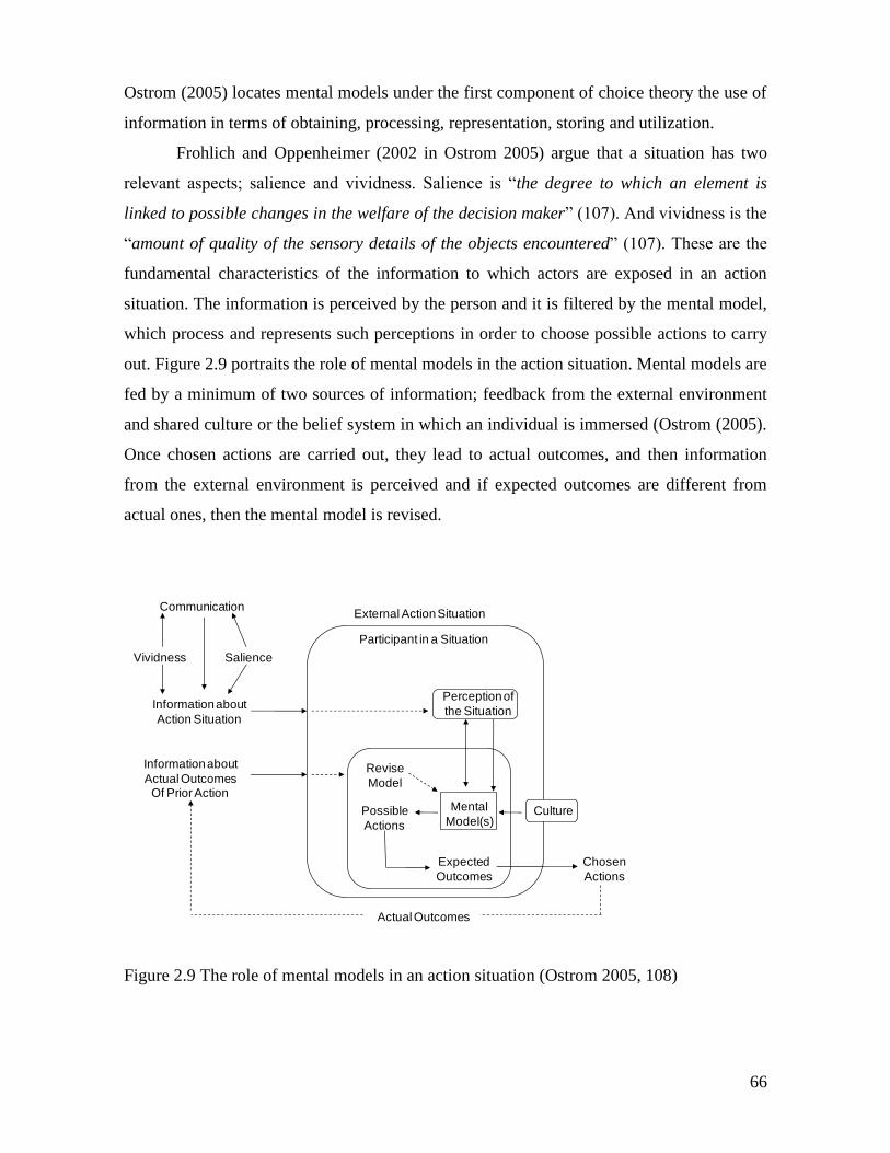
66
Ostrom (2005) locates mental models under the first component of choice theory the use of
information in terms of obtaining, processing, representation, storing and utilization.
Frohlich and Oppenheimer (2002 in Ostrom 2005) argue that a situation has two
relevant aspects; salience and vividness. Salience is “the degree to which an element is
linked to possible changes in the welfare of the decision maker” (107). And vividness is the
“amount of quality of the sensory details of the objects encountered” (107). These are the
fundamental characteristics of the information to which actors are exposed in an action
situation. The information is perceived by the person and it is filtered by the mental model,
which process and represents such perceptions in order to choose possible actions to carry
out. Figure 2.9 portraits the role of mental models in the action situation. Mental models are
fed by a minimum of two sources of information; feedback from the external environment
and shared culture or the belief system in which an individual is immersed (Ostrom (2005).
Once chosen actions are carried out, they lead to actual outcomes, and then information
from the external environment is perceived and if expected outcomes are different from
actual ones, then the mental model is revised.
Figure 2.9 The role of mental models in an action situation (Ostrom 2005, 108)
Mental
Model(s)
Perception of
the Situation
Revise
Model
Possible
Actions
Expected
Outcomes
Participant in a Situation
External Action Situation
Culture
Chosen
Actions
Actual Outcomes
Information about
Actual OutcomesOf Prior Action
Communication
Vividness Salience
Information about
Action Situation
67
If mental models belong to the first component of rational choice mentioned above;
use of information, strictly, behavior is in the third element; the strategies that lead to
concrete actions. Multiple theories of human decision making exists being the most popular
and common used the neoclassical Homo economicus, whose main characteristics are: self-
interest, outcome oriented, he always maximizes his own wealth, has discount rate that
privileges the short term, and full capacity of information processing (Gintis 2000). These
characteristics do not pose any problems in environments as competitive perfect markets
with complete information, but out of this world it seems not to resemble the way most of
persons behave. People in strategic situations are cooperative and pro social, they behave
more as Homo reciprocans being strong reciprocators. They cooperate when others
cooperate, but people punish others if they defect even if the punishment is costly (Gintis
2000, Gintis et al. 2003).
General moral conformance as evaluative criteria of the action situation’s outcomes
Though necessary, mental models are not enough to know the reasoning behind people’s
decisions. Mental models are strongly influenced by cultural and moral systems; therefore
it is necessary to revise the notions of morality. Evaluative criteria are essential in the
analysis of the outcomes generated by the action arena. These criteria are defined by the
objective of each study; in this case the investigation has been oriented to explore levels of
trust, cooperation and rule compliance. These variables are a function of the general
morality conformance constructed through time in a community and the different action
arenas in which common pool resources users are embedded could constantly reinforce
that. A given set of institutional arrangements could promote a moral system in a particular
action arena (Ostrom, 2005). Therefore a conceptual body is needed to interpret these
outcomes. In this section I revised the conceptual state of the art in morality studies and
discuss a conceptual framework useful to interpret the action arena’s outcomes.
From the economics perspective, traditionally the outcomes of actor’s decisions
have been studied with the utility concept, which put all the importance in the results and
its net benefits for the actor. Frey et al. (2004) contested this concept arguing that people is
not guided only by the outcomes utility but also by the procedural utility, meaning that
“people not only value actual outcomes, i.e., the what, but also the conditions and
processes that lead to these outcomes, i.e., the how.” (377). The authors emphasize that
procedural utility is an essential factor for human well-being. Questions about the fairness
68
of the processes to reach an outcome, and the easiness of rule breakers to reach high
payoffs among others, are central to evaluate the results of action arenas. This vision brings
the issue of the morality in the processes to reach outcomes.
Morality is fundamentally a personal decision, which corresponds with the notion
that each individual has about her life, and the public and private issues. However, this does
not mean that moral principles are absolutely relative and depend on each individual, on the
contrary there are some minimum principles that each human being has genetically
programed as part of her evolutionary inheritance. Scholars from the moral psychology
field claim that humans have developed a “moral instinct” independently of gender,
education, culture and religion (Hauser, 2007).
The morality issue is at the center of cooperation mechanisms, which in turn is
fundamental in the management of CPR. One of the mechanisms that produce important
levels of cooperation is reciprocity understood as the behavior in that a person cooperates if
the other person cooperates. This mechanism contributes to individual reputation building
and requires of two conditions: availability of good information about the others’ actions
(Nowak & Sigmund, K, 1998), and capacity to punish people with bad reputation, even
scarifying individual benefits, what is called “altruist punishment” (Nowak, 2006).
According Nowak (2006) there are five mechanisms that have contributed to the evolution
of cooperation: Familiar selection, direct reciprocity, indirect reciprocity, network
reciprocity, and group selection. The basis of these mechanisms can be explained with the
notion of the evolution of the “moral instinct”, and that the evolutionary selection has
occurred not only at individual level but also at group level (Haidt & Kesebir, 2010). The
need of eliminating the individual selfishness in groups contributed to morality
development during last 10.000 years. But this morality not only has to do with the
principles of harm, rights and justice that protect the individuality; it is a broader morality
that has to do with collective interests, and reinforces the idea about moral values
strengthening human groups. Scholars have proposed five hypothetical basis for morality:
1) Harm and care, 2) Justice, fairness and reciprocity, 3) In-group loyalty, that has to do
with the membership duties, self sacrifice and monitoring of possible defection, 4)
Authority and respect, related with the social order and the obligations of hierarchical
relations such as obedience, respect and the compliance of duties according to a role in the
group, and 5) purity and sanctity, concerned with physical and spiritual values such as
chastity, integrity, and desired control (Haidt, 2007; Haidt & Kesebir, 2010).
69
The field of moral economy explores the quiet resistance of peasant societies facing
the structural mechanisms of domination. Authors such as Thompson (1971) and Scott
(1977, 1987, 1992) have studied the characteristics of the resistance in the popular
discourse. Scott’s work has focused in the Asian Southeast but has had an important
influence in the Third World countries. The approach integrates the historical analysis, the
perception that communities have about themselves, and remarks the politic and cultural
characteristics that link the economic structure and collective action in rural and pre capital
societies. With these elements moral economy studies the way these societies face the
subsistence challenge and express economic criteria through moral normative content
(Floréz 1991). Moral economy studies the patterns of the shared norms expressed in rights
and duties of dominant and subordinate human groups, and how these systems built the
foundations for a rebellion collective action without coordination in most of the cases.
Therefore, this dynamics originates a shared moral universe, meaning a common notion of
fairness. In this type of analysis there are two important principles: 1) Reciprocity norms,
which is the basis for the interpersonal behavior, and 2) Subsistence rights, that define the
minimum needs to satisfy by the community members in the context of reciprocity (Floréz
1991). This form of distinction between legitimate and illegitimate practices emerges from
a consensus about an ideal past that has the power of inspire collective action in the present
(Arnold 2001). From this perspective legitimacy is embedded in the notions of “shared
moral universe” (Scott, 1977) or “shared way of life” (Ramsay 1996). Arnold (2001)
proposes a redefinition of the field. One of his points is that the ideas of universals and
shared systems do not allow observing the different sources of common legitimacy in a
given moment, hiding the reasons of communities for choosing different groups of
legitimizing rules.
The author proposes a moral economic political analysis based on social goods such
as water or in general common resources that communities are highly dependent on. Arnold
(2001) argues three reasons: 1) the notion of social goods is not limited to time and culture,
these goods and their moral economies are present in pre-modern and modern societies.
The issue of resistance is only one dimension of moral economies. 2) Social goods and
moral economies are not only the general moral economy, there are several systems
functioning at the same time. In words of Arnold, they are plural not singular. And 3) moral
economy is at the core of specific and dynamic social relations, not in static, generalized
and mechanistic moralities, or romanticized pasts. This conception of moral economy
70
contributes to evaluate the outcomes of the action arena in terms of the general morality
conformance, specially the notion of moral systems based on social goods that can be
classified as common pool resources.
Individual and collective moralities are fundamental for reaching or not high levels
of cooperation and trust, regarding common resources management. Moral systems are
linked to culture; therefore it is necessary to relate culture with natural resource
management. Pahl-Wostl et al. (2008) proposes a useful framework to explore the role of
culture and morality in natural resource management. Morality offers value judgments
about what is morally acceptable or not about specific situations (Pahl-Wostl et al. 2008). A
cultural framework includes "ideas, and ideals (values, attitudes, beliefs, norms) and
traditions and institutionalized social practices (e.g. behavioral rituals, language, rules,
legal practices) (Pahl-Wostl et al. 2008: 488). In terms of outcomes two levels of morality
conformance are identified: (1) normative and generalized beliefs that describe the
particular judgment of a given action in the case of the first, and the connection between an
action and an effect but without a value judgment. (2) I call second level of general
morality conformance with three sources of behavior regulation; moral, cultural and legal.
The criteria for classifying types of behavior into moral, cultural and legal groups arises
from the detailed field observations carried out in each of the three case studies of this
investigation. The examination of these three sources contributes to understand the "gap
between law, morality and culture" (Mockus 2002) for explaining the relation between
behavior and rules.
General morality conformity could be understood as the ultimate consequence of the
levels of cooperation and trust present in the system, or a condition for outcomes. This is
one of the issues I will explore in this research. Morality is understood as the value
judgments about what actions are right or wrong in this particular action situation. The
concepts of normative and generalized beliefs help to interpret the answers to the questions
posed by Ostrom (2005: 67), when discussing general morality outcomes:
"Are those who are able to cheat and go undetected able to obtain very high
payoffs? Are those who keep promises more likely to be rewarded and advanced in
their careers? How do those who repeatedly interact within a set of institutional
arrangements learn to relate to one another over the long term? Are the
procedures fair?"
71
A fundamental condition for rule compliance is their legitimacy among the
members that cover the Attribute characteristic. But the legitimacy is a function of the
perception by individuals of the rule’s fairness. The ADICO model provides a basis for the
study of fairness perception of rules. Sources of legitimacy or lack of it could be found in
one or several components of the rule. The effects of rules on the different components of
the action arena, through the examination of the AIM of rules is also relevant to understand
rule legitimacy and complements the insights from the ADICO approach. These two
perspectives contribute to understand how the rules shape the outcomes of action situations.
The legitimacy of rules finally determines the outcomes of action situations and produces a
shared moral system when the institutional arrangements have been working for a period of
time. This perspective suggests a relationship between formal law and moral. In the path
from formal rules to operational rules, in addition to a moral system, the culture is the other
critical characteristic of a social system that determines the level of rule compliance. The
social norms that emerge from a cultural system generally are closer to rules in use, than to
the formal prescriptions from the law. The cultural system is related with the law and with
the moral systems. The distance among these three components is of vital importance for
the levels of rule compliance, but also and more relevant, for morality system interpreted as
one of the outcomes of the action arena.
The following concepts proposed by Mockus (1994, 2002) contribute to evaluations
of this particular outcome of the action situation. Following Carillo’s concepts, in an
idealized democratic society the regulation of human behavior is achieved by three types of
systems: cultural, moral and legal. Morally valid behavior, according to the moral judgment
of the individual is usually accepted by culture, but the contrary is not necessarily true:
some culturally accepted behaviors are not followed by certain individuals, due to moral
considerations. In turn, culturally allowed behavior coincides with what the formal law
permits, but the opposite is not necessary valid: some formally allowed behaviors are
rejected culturally. In brief, in such societies, culture demands more than formal law and
morality more than culture (Mockus 2002). The idea of a separation among formal law,
morality and culture as an explanation of many social problems is expressed as follows:
"By the "gap between law, morality and culture" I mean the lack of consistency
between cultural regulation of behavior and its moral and legal regulation, a lack
of consistency that is expressed as violence, delinquency, corruption, illegitimacy of
72
institutions, weakening of the power of many cultural traditions and a crisis or
weakness of individual morality." (Mockus 2002: 23)
According to these relationships, Mockus identifies Colombia as a society that
exhibits a wide gap between law, morality and culture. From this perspective there are three
types of formal lawbreakers. The rule breaker by conviction breaks the rules because he has
a number of ideals and interpretations about reality that push/motivate him, and his
behavior is regulated by moral considerations. The rule breaker by necessity or
convenience breaks the rule because he has particular utility motivations. And the cheating
player, who regulates his behavior by shared cultural codes, and has some respect for the
game he is in. The last two types of players can find moral justifications for their behavior
but they are aware that others could have better moral arguments (Mockus 1994). The
concepts discussed in this section will be fundamental for the study of action arena’s
outcomes in this research.
In this section I have discussed the role of institutions in SESs` governance and the
proposed framework of the Institutional Analysis and Development (IAD) to for the
analysis. The IAD offers a framework in which the action arena is the unit of analysis
where actors act constrained by institutional arrangements, and guided by their mental
models to choose what actions are the bests for their interests. The evaluative criteria for
the outcomes of the action arena though could be very diverse; I focused in the general
morality conformance as one of the main products of the action arena dynamics, and as the
driver of levels of trust and cooperation in a SES. In the next section I present the general
framework for the analysis of SESs proposed by Ostrom (2007, 2009) as a diagnostic and
multitier system to describe and analyze a SES. This framework allows to see the system
from a general perspective, but also permits to explore in detail certain subsystems and
variables. The section ends with a revision of the model of collective action (Ostrom 1998)
interpreted as the core variables in a cooperation dilemma and its importance for the
governance of a SES. This revision attempts to connect this model with the contextual
variables of the general framework for the analysis of SES.
73
2.5. A framework for the analysis of governance of
Social-Ecological Systems (SESs)
The integral understanding of ecosystems in which action situations occur is of paramount
importance. In recent publications (Ostrom 2007, Ostrom 2009, Poteete et al. 2010) special
attention has been paid to the construction of a unifiying language and a framework for
describing and analyse complex SESs. The multilevel framework is aimed to understand
complex SESs and the relationships among the different levels at different spatial and
temporal scales. For that purpose, it is necessary to know specific variables and their
relationships (Ostrom 2009), therefore “we must learn how to dissect and harness
complexity, rather than eliminate it from such systems” (420). The framework elaborates on
IAD and the framework by Anderies et al. (2004) discussed above in the resilience section
(Ostrom 2007). The framework aims to help researchers to develop answers to the
following questions when studying SESs:
1) “What patterns of interactions and outcomes … are likely to result from using a
particular set of rules for the governance, ownership, and use of a resource
system and specific resource units in a specific technological, socioeconomic,
and political environment?
2) What is the likely endogenous development of different governance
arrangemengts, use patterns and outcomes with or without external financial
inducemenmts or imposed rules?
3) How robust and sustainable is a particular configuration of users, resource
system, resource units, and governance system to external and internal
disturbances?” (Ostrom 2007, 15182).
The author remarks the importance of developing governance arrangements
that match with specific problems of SESs by urging “policy makers adopt a learning
process rather than imposing final solutions” (Ostrom 2007, 15181). Author’s call is for
not developing policy panaceas, or single sector policies that could have negative effects on
other subsystems, and hence on the outcomes of a SES. Governance of complex SESs
could not be achieved by simple and inflexible solutions, it needs policy design and tools
able to cope with diversity and complexity of problems taking into account contexts at
different scales.
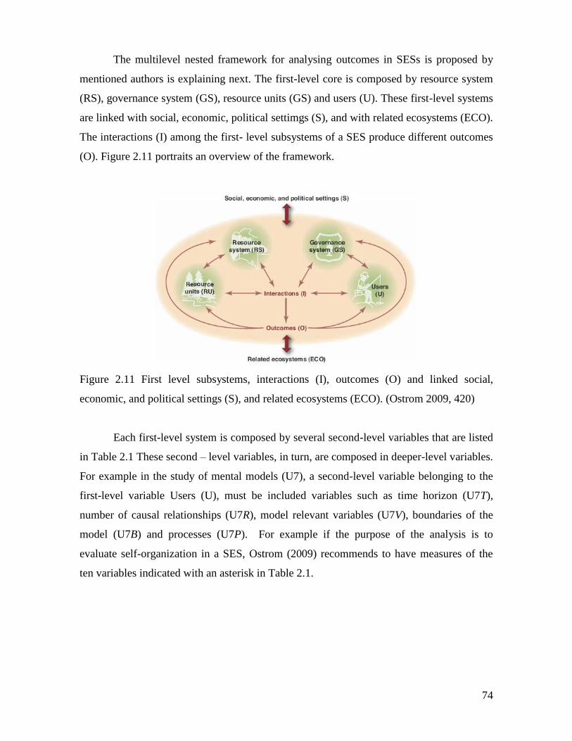
74
The multilevel nested framework for analysing outcomes in SESs is proposed by
mentioned authors is explaining next. The first-level core is composed by resource system
(RS), governance system (GS), resource units (GS) and users (U). These first-level systems
are linked with social, economic, political settimgs (S), and with related ecosystems (ECO).
The interactions (I) among the first- level subsystems of a SES produce different outcomes
(O). Figure 2.11 portraits an overview of the framework.
Figure 2.11 First level subsystems, interactions (I), outcomes (O) and linked social,
economic, and political settings (S), and related ecosystems (ECO). (Ostrom 2009, 420)
Each first-level system is composed by several second-level variables that are listed
in Table 2.1 These second – level variables, in turn, are composed in deeper-level variables.
For example in the study of mental models (U7), a second-level variable belonging to the
first-level variable Users (U), must be included variables such as time horizon (U7T),
number of causal relationships (U7R), model relevant variables (U7V), boundaries of the
model (U7B) and processes (U7P). For example if the purpose of the analysis is to
evaluate self-organization in a SES, Ostrom (2009) recommends to have measures of the
ten variables indicated with an asterisk in Table 2.1.
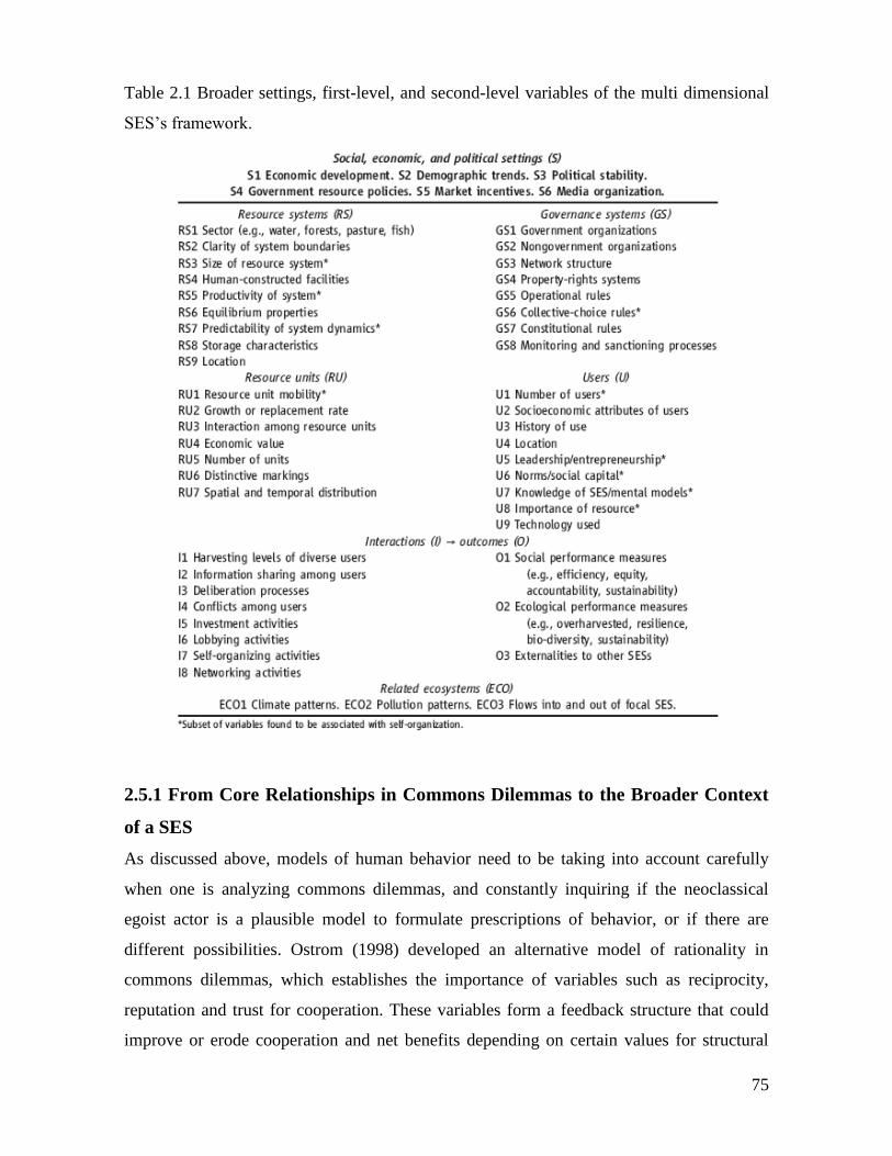
75
Table 2.1 Broader settings, first-level, and second-level variables of the multi dimensional
SES’s framework.
2.5.1 From Core Relationships in Commons Dilemmas to the Broader Context
of a SES
As discussed above, models of human behavior need to be taking into account carefully
when one is analyzing commons dilemmas, and constantly inquiring if the neoclassical
egoist actor is a plausible model to formulate prescriptions of behavior, or if there are
different possibilities. Ostrom (1998) developed an alternative model of rationality in
commons dilemmas, which establishes the importance of variables such as reciprocity,
reputation and trust for cooperation. These variables form a feedback structure that could
improve or erode cooperation and net benefits depending on certain values for structural
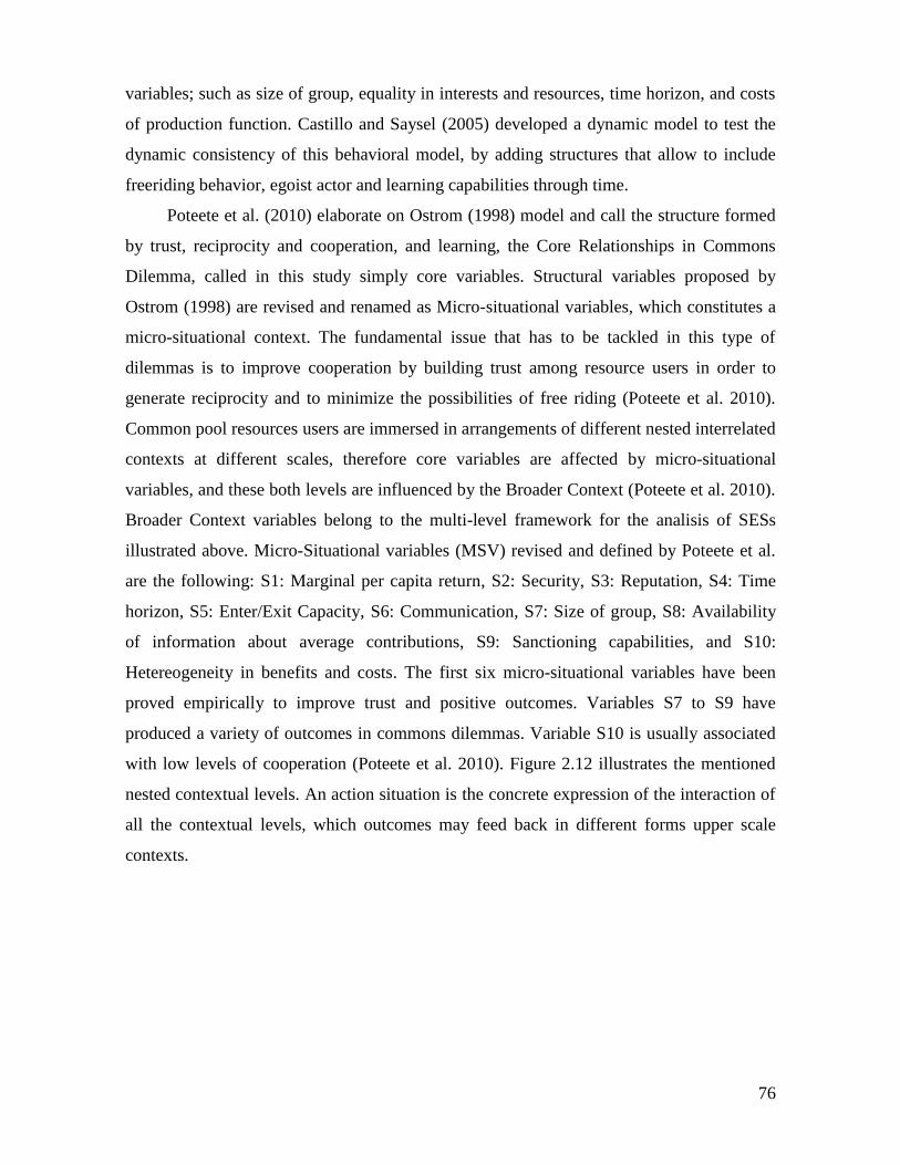
76
variables; such as size of group, equality in interests and resources, time horizon, and costs
of production function. Castillo and Saysel (2005) developed a dynamic model to test the
dynamic consistency of this behavioral model, by adding structures that allow to include
freeriding behavior, egoist actor and learning capabilities through time.
Poteete et al. (2010) elaborate on Ostrom (1998) model and call the structure formed
by trust, reciprocity and cooperation, and learning, the Core Relationships in Commons
Dilemma, called in this study simply core variables. Structural variables proposed by
Ostrom (1998) are revised and renamed as Micro-situational variables, which constitutes a
micro-situational context. The fundamental issue that has to be tackled in this type of
dilemmas is to improve cooperation by building trust among resource users in order to
generate reciprocity and to minimize the possibilities of free riding (Poteete et al. 2010).
Common pool resources users are immersed in arrangements of different nested interrelated
contexts at different scales, therefore core variables are affected by micro-situational
variables, and these both levels are influenced by the Broader Context (Poteete et al. 2010).
Broader Context variables belong to the multi-level framework for the analisis of SESs
illustrated above. Micro-Situational variables (MSV) revised and defined by Poteete et al.
are the following: S1: Marginal per capita return, S2: Security, S3: Reputation, S4: Time
horizon, S5: Enter/Exit Capacity, S6: Communication, S7: Size of group, S8: Availability
of information about average contributions, S9: Sanctioning capabilities, and S10:
Hetereogeneity in benefits and costs. The first six micro-situational variables have been
proved empirically to improve trust and positive outcomes. Variables S7 to S9 have
produced a variety of outcomes in commons dilemmas. Variable S10 is usually associated
with low levels of cooperation (Poteete et al. 2010). Figure 2.12 illustrates the mentioned
nested contextual levels. An action situation is the concrete expression of the interaction of
all the contextual levels, which outcomes may feed back in different forms upper scale
contexts.
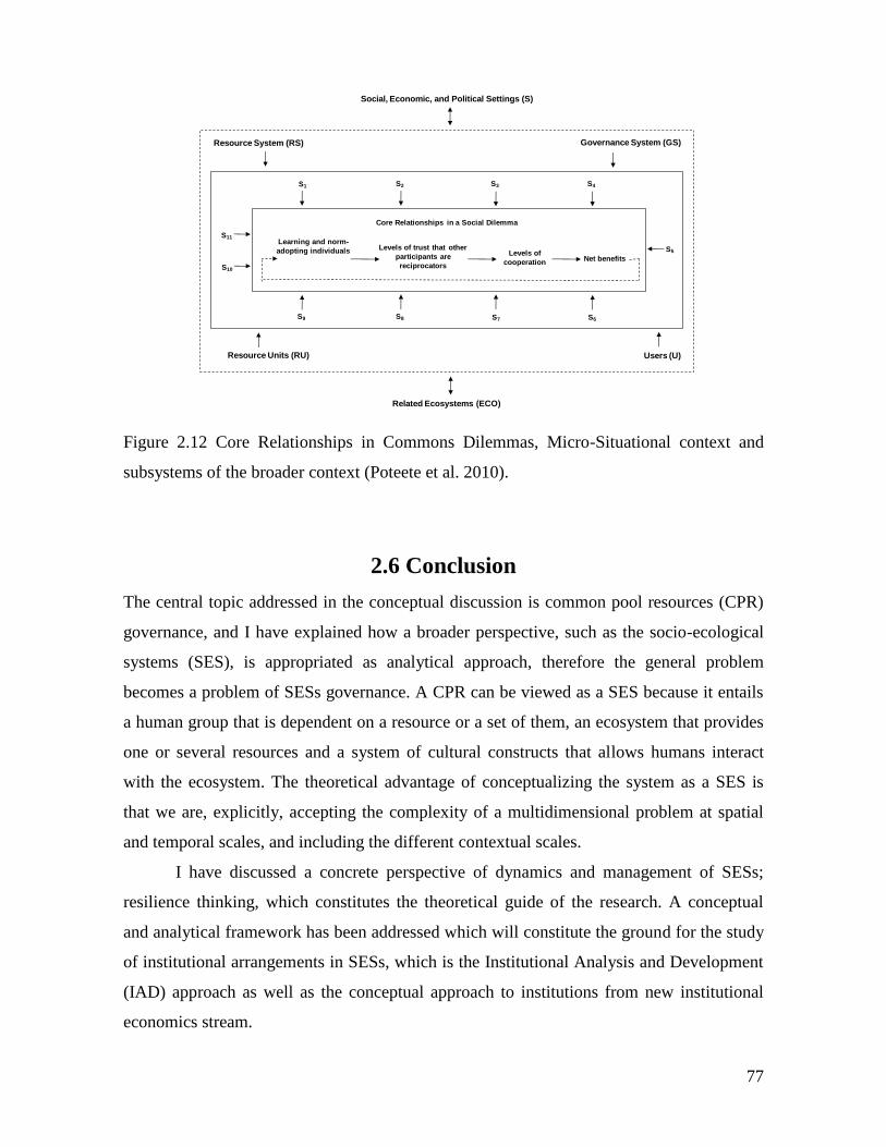
77
Figure 2.12 Core Relationships in Commons Dilemmas, Micro-Situational context and
subsystems of the broader context (Poteete et al. 2010).
2.6 Conclusion
The central topic addressed in the conceptual discussion is common pool resources (CPR)
governance, and I have explained how a broader perspective, such as the socio-ecological
systems (SES), is appropriated as analytical approach, therefore the general problem
becomes a problem of SESs governance. A CPR can be viewed as a SES because it entails
a human group that is dependent on a resource or a set of them, an ecosystem that provides
one or several resources and a system of cultural constructs that allows humans interact
with the ecosystem. The theoretical advantage of conceptualizing the system as a SES is
that we are, explicitly, accepting the complexity of a multidimensional problem at spatial
and temporal scales, and including the different contextual scales.
I have discussed a concrete perspective of dynamics and management of SESs;
resilience thinking, which constitutes the theoretical guide of the research. A conceptual
and analytical framework has been addressed which will constitute the ground for the study
of institutional arrangements in SESs, which is the Institutional Analysis and Development
(IAD) approach as well as the conceptual approach to institutions from new institutional
economics stream.
Social, Economic, and Political Settings (S)
Learning and norm-
adopting individuals Levels of trust that other
participants are
reciprocators
Levels of
cooperationNet benefits
S9 S8 S7
S10
S11
S6
S5
S4S3S2S1
Core Relationships in a Social Dilemma
Governance System (GS)Resource System (RS)
Resource Units (RU) Users (U)
Related Ecosystems (ECO)
78
Figure 2.13 shows schematically the general conceptual approach used in this
chapter. The central topic is framed in the context of CPRs, which constitutes a class of
social dilemma. This dilemma has been conceptualized and tried to solve through out the
“conventional theory” built upon Hardin (1968)’ tragedy of the commons, the use of the
prisoners dilemma methafore through game theory, and the theory of collective action
proposed by Olson (1965). This approach assumes the rational actor as the standard model
for human behaviour, which basically sees people as selfish that are driven only by the
maximization of their own benefits. As a consequence coordination and cooperation among
individuals is difficult to achieve, therefore it needs private property rights, and external
and imposed rules to avoid the so-called “tragedy”. This situation has been formalized with
the Prisoners Dilemma model that permits predictions of outcomes based on the previous
assumptions. The natural resource management has been deeply influenced by this
approach during the second half of the twentieth century, focusing on command and control
policies. On the other hand, the alternative to this theory starts to emerge with the seminal
work of Ostrom (1990) with the study of many cases of successful cases of CPR
management carried out without external imposition of rules giving evidences of self-
governance capabilities of local communities. This program of research produced the so-
called the alternative model of collective action (Ostrom 1998) that includes variables such
as trust, reciprocity and reputation in a behavioural model of decision-making in CPR
contexts. Also the model remarks the important role of the context in CPR decision-
making. Experimental economics also contributed to the volume of evidences that have
undermined the Homo economicus model as the generalized model of human decision-
making.
In the figure 2.13 the “CPR Alternative model of collective action” is linked to
socio-ecological systems (SES) box due to its usefulness and pertinence regarding the
theoretical basis and perspective of SES management. Among these common points are
concepts such as self-organization, diversity, learning, adaptation and complexity. The grey
box in figure 2.13 represents the main subsystems of a SES, and illustrates how the unit of
analysis proposed by the Institutional Analysis (IAD), the Action Arena, is where the
interactions (I) among actors and the different subsystems occur. These interactions
generates outcomes (O) that feedback the SES’ subsystems. The SES box includes the
concept of resilience management because this is a notion that includes the dynamic
perspective to the SESs analysis, and moves the natural resource paradigm from command
79
and control towards a management of change. The so-called resilience thinking needs
approaches that include adaptive capacity, self-organization, social learning and in general
complexity concepts to deal with uncertainty and change. Under this conceptual umbrella
the emphasis was made is in the governance (GS) and users systems (U) in the light of the
action arena. The conceptual tools used, and represented schematically in figure 2.13
contribute to understand the functioning of the CPR conceptualized as a SES.
Figure 2.13. General conceptual diagram that guides the conceptual state of the art
Figure 2.14 shows the variables in which the conceptual revision has been focused.
Four variables from the users and governance systems are relevant for the study: social
norms (U6) and mental models (U7) from the users system, and operational rules (GS5),
monitoring and sanctioning processes (GS8) from the governance system. These variables
synthetize the institutional arrangements and the mental models of CPR users. In order to
80
understand the relation between these two variables a theoretical revision has been made to
define them. Therefore an analytical framework for the study of rules and norms was used:
Institutional Analysis and Development (IAD). The action arena was used, as unit of
analysis of the interactions and the evaluative criteria for outcomes is the conformance to
general morality, which underlies the levels of trust and cooperation of the group of users
of a CPR. The theoretical revision (figure 2.14) helps to shed light on the issue of the CPR
management regarding the relation among users’ mental models, rules and social norms. In
order to study the outcomes of the action arena it is necessary to establish the evaluative
criteria that will guide the analysis. These criteria are conformance to general morality and
cooperation and trust levels. Therefore, it is necessary to take into account concepts related
to moral economy and behavioral sciences. In the figure 2.15 the relations among these
concepts are illustrated.
Figure 2.14. Specific variables studied in the conceptual state of the art.
Figure 2.14 portraits a general scheme conceptual scheme in which the action arena
is at the core of the system as the unit of analysis, which produces a set of outcomes that are
81
evaluated by specific evaluative criteria. In order to illustrate the use of these criteria a
zoom in the action arena’s outcomes (O) is necessary to study the relation among
institutional arrangements, mental models and moral systems. Figure 2.15 portraits a
general diagram that explains the concepts discussed in the chapter. The moral instinct that
humans have developed by evolution (Haidt, 2007; Haidt & Kesebir, 2010; Hauser, 2007)
is a first input for the moral systems. According to Arnold (2001) these moral systems are
attached to social goods (CPR). This relation is used to build a particular moral economy.
Moral instincts and moral economies contribute to shape the first level of morality
conformance. This level is composed by generalized and normative beliefs (Pahl-Wostl et
al. 2008). This level generates a second level of morality conformance. This second level
assumes that there are three sources of regulation in human behavior. These three sources
are moral, culture and formal prescriptions (legal). The examination of these three sources
contributes to understand the "gap between law, morality and culture" (Mockus 2002) for
explaining the relation between behavior and rules. The result of these three fields is one of
the generators of trust and cooperation levels, and the behavioral spectrum showed in the
central box of the figure. The other inputs for behavior are the mental models that are
composed by variables, and cause-effect relations between them. The behavioral spectrum
feeds back the moral economy, and becomes in a reinforcing driver of the moral system.
On the other hand, three aspects feed the mental models: cultural elements, generalized
beliefs and the feedback from the general outcomes themselves. Finally, the institutional
arrangements are influenced by mental models, and they affect the moral economic system,
which in turn feeds back key aspects of these institutional arrangements such as rule
compliance, norms, endogenous rules and agreements.
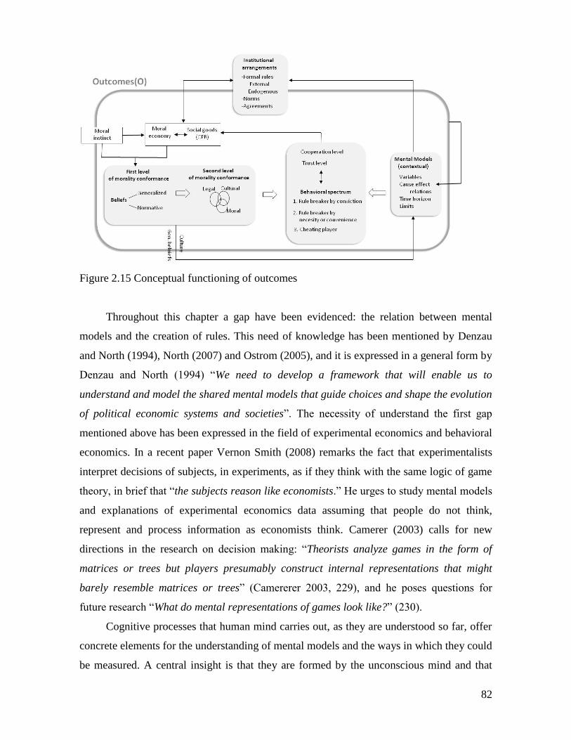
82
Figure 2.15 Conceptual functioning of outcomes
Throughout this chapter a gap have been evidenced: the relation between mental
models and the creation of rules. This need of knowledge has been mentioned by Denzau
and North (1994), North (2007) and Ostrom (2005), and it is expressed in a general form by
Denzau and North (1994) “We need to develop a framework that will enable us to
understand and model the shared mental models that guide choices and shape the evolution
of political economic systems and societies”. The necessity of understand the first gap
mentioned above has been expressed in the field of experimental economics and behavioral
economics. In a recent paper Vernon Smith (2008) remarks the fact that experimentalists
interpret decisions of subjects, in experiments, as if they think with the same logic of game
theory, in brief that “the subjects reason like economists.” He urges to study mental models
and explanations of experimental economics data assuming that people do not think,
represent and process information as economists think. Camerer (2003) calls for new
directions in the research on decision making: “Theorists analyze games in the form of
matrices or trees but players presumably construct internal representations that might
barely resemble matrices or trees” (Camererer 2003, 229), and he poses questions for
future research “What do mental representations of games look like?” (230).
Cognitive processes that human mind carries out, as they are understood so far, offer
concrete elements for the understanding of mental models and the ways in which they could
be measured. A central insight is that they are formed by the unconscious mind and that
83
logical rational to explain them comes after actions have been carried out, elaborated by the
conscious mind. This fact has methodological implications. Elicitation of mental models
implies the use of not direct questioning tools to natural resources users, it needs tools that
allow to connect actions, users nonconscious constructs, and contextual environments. The
detailed discussion about the methodological approach is developed in chapter 3.
An analytical umbrella that has been described towards the end of the chapter is the
general framework for analyzing sustainability of SESs (Ostrom, 2007 and 2009). This
framework elaborates on IAD, Anderies et al. (2004) framework for robustness of SES, as
well as on the call for the inclusion of a number of critical aspects in the analysis of SES
made by Walker et al. (2006).
84
3 METHODOLOGICAL FRAMEWORK
In the introduction I have identified a research problem throughout a revision of the
situation of the major world common pool resources, which focuses in the link between
CPR management, mental models and institutions as a possible perspective that could
provide a basis for the design and assessing of a variety of policy experiments in common
pool resources governance. The topic that will be addressed in this study is the cognitive
problem underlying common pool resources dilemmas in socio-ecological systems (SES).
Therefore the research question that I intend to answer is: What is the relation between
mental models of common pool resources’ users and the institutional arrangements to
manage the common resources? In the theoretical state of the art developed in chapter 2 I
have provided a conceptual framework to address the research problem identified in the
introduction. This conceptual approach provides the basis for the formulation of three
specific objectives to address the question stated above, and the methodological framework
as well. From this conceptual exposition it is clear that common pool resources (CPR) need
to be studied in the context of the social-ecological system (SES) that they are embedded
in. Therefore, the first specific objective of this research is to define the socio ecological
system of each case study. From this SES scale I focus on the institutional arrangements as
a relevant sub-system (of the SES) that structures, not only the relation between societies
and ecosystems from an aggregated perspective, but also at individual level. Consequently,
the second specific objective of this study is to carry out an institutional analysis (IAD) to
understand the action arenas in which CPR users are immersed and its outcomes as well.
But according to the conceptual discussion (chapter 2), on one hand, there is an agreement
among neo-institutional and sustainability scholars in that the institutional arrangements are
strongly influence by collective and individual mental models. On the other hand, in order
to understand the decisions of CPR users in action arenas, which in turn are embedded in an
institutional matrix, is necessary to investigate the mental models. Therefore, the third
specific objective of this study is to study the mental models of the CPR users in each of
85
the case studies. The aim of this chapter is to construct a methodological framework to
address each of these three objectives, and contribute to understand the relation between
mental models and institutional arrangements.
The chapter is organized in three sections; research posture, the methodological
process and the tools utilized, and a brief conclusion. In the research posture section, I first
discuss the companion modeling (ComMod) perspective and its implications for common
pool resources (CPR) management; next I present a brief overview of participation in
natural resource management and modeling tools, and finally, I explain the relation
between the ComMod perspective and experimental economics. The following section
presents the methodological framework and explains each one of the tools used in the
research, and a brief conclusion finalizes the chapter.
3.1 Research posture
The nature of the topics addressed by the research question requires the combination of
several methodological approaches and tools. This need comes from the fact that any
methodology has limitations and that there are trade-offs when a researcher privileges one
method over others. In order to solve this problem it is necessary to utilize multiple
methods, which are complementary. There are some conditions for adopt a multi method
approach: scarce data, difficulties in data collection, and not easily comparable. The study
of informal institutions and non-elite populations are among topics that have the
characteristics mentioned. The research on collective action for the management of natural
resources, which is the general theme of this dissertation, has all the mentioned conditions
(Poteete et al., 2010). In addition to that, it is important to remark that the methodological
choice in this study represents values, beliefs and practical considerations of the researcher
and his position regarding science and the people object of the study.
The methodological position from which this research has been developed relies on
specific premises which are in line with, Bousquet & Barreteau (1999), Bousquet et al.(
2003), Barreteau & and others, (2003), and Ferber (1999) . The general perspective can be
expressed with the following ideas. The SES are complex objects in which the decision
making process could not seek system prediction. Instead, it seeks to understand
organizational aspects, to incentive system interactions that drive change, to monitor these
86
changes, to provide ideas for adaptation and learning. Every actor and stakeholder has an
experience that contributes to the development of his own perspective of the SES. These
are social constructs that have been built according to actors’ specific culture and values. In
consequence, decision-making and natural resources management processes rely on
dialogue processes among different actors, with the consequence that the decisions are
jointly constructed (Bousquet et al., 2011) .
The approach of the companion modeling (ComMod) developed by a group of
CIRAD researchers offers postures and premises that have adopted in this study. ComMod
is, first of all, a posture with ethical consideration about participatory modeling (Barreteau
& and others, 2003) . Secondly it proposes a methodology (Bousquet & Barreteau, 1999)
that comprehends a set of innovative, flexible and dynamic tools to foster diverse forms of
collaborative management which include strategies to monitor change in SESs. The
approach assumes that mental models of all the actors involved in SESs, including,
researchers and regulation agencies are relevant, and the knowledge produced by each
stakeholder has to be included in the solutions to governance puzzles in SESs. It provides
the space for different stakeholders to express their points of view, and it acknowledges the
fact that actors do not have the same weight; they are embedded in power relationships. In
this line, the conceptual and methodological proposal has a clear posture, in the sense that
the different perspectives of the problems have to be integrated in the solutions. Possible
management arrangements in a given context have to be crafted according to the particular
characteristics and needs of the SESs instead of implement a blueprint solution as a panacea
(Berkes, 2007; Ostrom, 2007). At the core of this posture is the “discussion of pluralistic
approaches, such as the distribution of authority across multiple institutions” (Berkes,
2007) and the understanding of social organizations and their relation with natural
resources management policies, in order to collaborate to find ways to reach local scale
sustainability that has into account regional and national institutional arrangements.
3.1.1 Companion modeling and co-management of common pool resources
The ComMod approach has been developed to support collective management of
ecosystems, and particularly it has been inspired by adaptive management, co-management
approaches and patrimonial mediation (Bousquet & Trebuil, 2005). The approach was
proposed in 1999 “for better understanding and modeling of the decision-making process
and for better management of natural renewable resources”. (Bousquet et al., 2003).
87
Ollagon (1991 in Bousquet and Trebuil (2005) defines patrimonial as “all the material and
non material elements that work together to maintain and develop the identity and
autonomy of their holder in time and space through adaptation in a changing
environment.” Bousquet and Trebuil (2005) define a patrimonial representation of a
territory as “an area, or a set of resources links, past, present, and future generations of
managers, focuses on the owner’s obligation more than on the owner’s right, and promotes
a common vision of sustainability that reconciles the needs and opinions of various actors”.
In a collaborative management process where multiple and different interests and
perspectives play, negotiation methods and skills are fundamental in order to reach
management agreements. Concertation is the negotiation tool that companion modeling
approach utilizes as a way to facilitate reaching agreements, and it consists of a third party
that facilitates, transfer knowledge and proposals among stakeholders.
Governance of local common pool resources is especially complex because of their
characteristics in terms of exclusion and subtractability due to property rights regime, in
addition to resource dynamics when we refer to natural renewable resources. In such
context stakeholders’ mental models and interests’ differences in reaching consensus about
resource dynamics, rule preferences and rule crafting are especially critical. In order to face
this type of puzzle; sharing and representation of actors’ perceptions, tools to construct and
simulate different management scenarios contribute to negotiate collective strategies to
reach sustainable institutional agreements. Companion modeling offers an adaptive
methodological framework for research and problem solving in resources management, that
enables collective modeling of perceptions, discussion and negotiation, and also contributes
to the understanding and practice of co-management.
3.1.2 Management, participation and modeling tools
Several approaches have been developed to support problem solving in environmental
management using participative modeling and simulation. System dynamics field has
provided a framework developed in business administration arena focused on decision-
making processes and organizational learning known as Group Model Building (Vennix,
1996) using stock and flow and causal diagramming representation. Platforms such as
Stella, Vensim and Powersim software have been the most used in the field. Pioneering
works in applying this approach to environmental management are (Costanza & Ruth,
1998) and (Van den Belt, 2004). System dynamics modeling approach allows to
88
representing and simulating non-linear complex systems and feedback-controlled structures
from an aggregated perspective. A review of participatory modeling to support problem
solving in environmental management has been carried out by Bousquet et al. (2003), in
which they remark the work of several authors who illustrate different approaches to
participatory management and assessment process, some of them including geographic
information systems (GIS) tools. A common characteristic of the literature mentioned
above is that models have been developed by researchers in order to offer a platform for
consensus building, negotiation, strategic planning or assessment, and the models has been
constructed in order to represent the ecosystem or resource at stake.
Multi Agent System (MAS) is a term applied to a system comprising an
environment, a group of objects, an assembly of agents representing the active entities of
the system, an assembly of relations, a group of operations which make possible for agents
to perceive, produce, consume, transform and manipulate objects, and a set of operators
(Ferber, 1999). MASs allows representing and simulating communication and interactions
among agents, individual decision rules, and can include mechanisms to self-transformation
of the system. It is possible to observe and study emergent behavior patterns at global scale
arisen from micro scale interactions among agents. MAS modeling have been used to
represent perceptions of agents regarding natural resources and observe the consequences
of decision based on such mental models on the whole system (Janssen, 2003).
Companion modelling framework includes MASs linked to role games assuming
that they “share a common representation of complexity and can thus enrich each other”
(Bousquet et al., 2003). The MAS concept is fundamental in the ComMod approach. It is
used at conceptual and analytical level, but also it is used to represent and implement
concrete artifacts such as computer simulations and role-playing games or a combination of
both. In a companion modeling process there are three objectives for which models are
used: To make heterogeneous perspectives visible and open to debate, to discuss the
consistency of different viewpoints and the possible scenarios product of their simulation in
relation with the real world, and to generate a space for exploring scenarios collectively
using simulations in virtual worlds (Le Page et al., 2011) . In this approach a constructivist
position is adopted in the sense that the reality is constructed by each actor and at the same
time is the result of the interactions of such constructions. Therefore, each vision of the
world can be represented and constructed trough the modeling process, which is an
“explicit writing process in which knowledge and heterogonous hypotheses are distributed
89
in the same artefact” (p. 70. (Le Page et al., 2011). In this view, representing the “real
world” means representing hypotheses about it that can interact among them. This
representation of actor’s perspectives of the problem being studied is usually carried out
through MAS models.
Different from other modeling approaches the MAS approach entails the description
of a world where there are active entities (agents) that play roles aiming to manage the
system. From this perspective MASs are taken as metaphors of reality and strictly speaking
the concept does not make any reference to computer science (Le Page et al., 2011). This
precision is important because the MAS concept can be used to represent and interpret
natural resources management problems without implementing simulation models, for
example role playing games (RPG).
3.1.3 Companion modeling and experimental economics
Companion modeling approach aims to “facilitate dialogue, shared learning, and
collective decision making through interdisciplinary and “implicated” research to
strengthen the adaptive management capacity of local communities” (Gurung et al., 2006).
In order to achieve such objectives modeling is at the core of the approach to understand
and integrate actors mental models. Models include any kind of problem or system
representation in which a level of abstraction is used. Such models can be geographic
representations, multi-agent systems, stock and flow diagrams, causal diagrams and role-
playing games among others. Comodians, term coined by (Barreteau et al., 2011) to refer to
researchers familiar with the ComMod approach and following the approach ethical
principles, have focused in multi-agent systems and role games (Barnaud, 2008). In this
research we have utilized economic experiments as a complement to role-playing games,
and the ComMod posture, as a modeling device and second phase in order to answer
specific research questions in a controlled setting that could be reproduced.
It is important to clarify that experimental economics is a modeling exercise of the
researchers and it intends to produce information about decisions and rationalities of actors.
It is important to clarify that game theory and experimental economics are not considered a
participative approach, but it constitutes a useful modeling perspective that open the door to
a ComMod process. Experiments are not considered as integral part of the companion
modeling approach. The hypotheses of a game theory model is implicit in the economic
experiment and is not transparent to the participants. Its usefulness rests on the possibility
90
to present the researcher’s model of the problem to the actors starting a discussion towards
the collective construction of a role playing game. Experimental economics is a
methodological approach based on game theory. Its objective is to test economic theories
through the modeling having specific hypothesis with the aid of game theory.
Game theory approach allows to model situations of interdependence among actors
where all the possible choices are known, and the strategies of agents are used to study
different rationalities. This is accomplished by carrying out experiments with human
subjects in a highly controlled environment. Traditionally, experiments have been done
with students in universities, but (Cardenas & Ostrom, 2004) and others have done
experiments with real users of natural resources in rural environments. Hypothesis about
how variables such as information, cooperation, reciprocity, risk aversion, effect of
institutions and communication, among others affect decision making in the use of natural
resources have been tested with rural common pool resources users by several authors.
Economic experiments coupled with simulation modeling (MASs and System Dynamics)
have been used to understand, test dynamic consistency of theoretical behavioral models
and generate new hypothesis to test (Castillo & Saysel, 2005; Deadman P, 1999) proposing
a double loop of decision making inquiry using both tools in a continuous feedback
research system (D. Castillo & Saysel, 2005). In sum, the researcher’s model (experiment)
serves as basis for a more complex model (role-playing game) in which mental models of
several actors are represented.
Role Playing Games have been used numerous times in the field of fisheries
management since the developing of the emblematic Fish Banks Ltd. (Meadows et
al.1989), to help students and stakeholders to understand problems and the tragic
consequences of overfishing. The approach followed in this research uses RPG to
understand rule-crafting dynamics and adopts the principles of Companion Modelling
(Barreteau et al. 2003). A complete review of RPGs and modeling in natural resource
management is done by Bousquet et al. (2002). The co-construction of a RPG refers to a
group of participants that in the experiments, along with researchers, design and test a game
with the objective, set collectively, to discuss and negotiate rules of use regarding the
common resource. The process allowed for observation of how the participants bring the
most relevant elements into the new game from their micro-situational and broader context
variables; as well as their attitudes towards rules and the collective rule crafting process .
91
RPGs and modeling constitute the core of the Companion Modeling (ComMod)
approach (Barreteau et al. 2003). According to Bousquet and Trebuil (2005), the
methodology is epistemologically based on the idea that people build their own realities
through the process of social learning. Barreteau et al. (2003) states that the results that the
methodology could yield can be classified in three types: 1) change of stakeholders’
perceptions, 2) modeling, the transformation of existent knowledge in a formal tool to be
used as a simulator, and 3) concrete actions. This approach can be used in two different
contexts, the first has to do with knowledge production about complex systems, to be used
here, and the second is oriented towards the companion of the decision making processes
(Barreteau et al. 2003).
Role playing games and modeling either multi-agent based modeling or system
dynamics tools are part of the ComMod (Barreteau et al. 2003) methodological framework.
According to Bousquet and Trebuil (2005), the methodology is epistemologically based in
the idea that persons build their own realities through the learning in social processes. The
so-called hard sciences that emphasize objectivity can demonstrate the biophysical
conditions and problems in an ecosystem, “but sustainable land use is defined as the
outcome of human interaction and agreement, learning, conflict resolution, and collective
action” (Bousquet and Trebuil 2005).
Companion modeling implies an iterative permanent procedure between theory and
field context, therefore the method is based in a loop between models and field. Barreteau
et al. (2003) state that the results the methodology could yield can be classified in three
types: 1) knowledge production about complex systems, 2) modeling, the transformation of
existent knowledge in a formal tool to be used as a simulator, and 3) concrete actions. The
approach can be used in two different contexts, the first has to do with knowledge
production about complex systems, and the second is oriented towards the companion of
decision making processes (Barreteau et al. 2003). In this research, the method is oriented
towards the first purpose, knowledge production about complex systems. Although it is
necessary to verify by monitoring of communities, we claim that there is an effect of
awareness and learning that could strength the local adaptive management. This objective
does not make part of this research.
The general structure of the process is cyclic, and comprehends three states that could be
repeated as many times as needed: 1) Field research and secondary sources collection in
order to generate explicit hypotheses for the modeling process, 2) transformation of
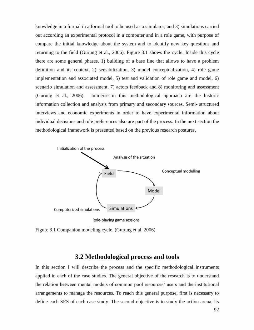
92
knowledge in a formal in a formal tool to be used as a simulator, and 3) simulations carried
out according an experimental protocol in a computer and in a role game, with purpose of
compare the initial knowledge about the system and to identify new key questions and
returning to the field (Gurung et al., 2006). Figure 3.1 shows the cycle. Inside this cycle
there are some general phases. 1) building of a base line that allows to have a problem
definition and its context, 2) sensibilization, 3) model conceptualization, 4) role game
implementation and associated model, 5) test and validation of role game and model, 6)
scenario simulation and assessment, 7) actors feedback and 8) monitoring and assessment
(Gurung et al., 2006). Immerse in this methodological approach are the historic
information collection and analysis from primary and secondary sources. Semi- structured
interviews and economic experiments in order to have experimental information about
individual decisions and rule preferences also are part of the process. In the next section the
methodological framework is presented based on the previous research postures.
Figure 3.1 Companion modeling cycle. (Gurung et al. 2006)
3.2 Methodological process and tools
In this section I will describe the process and the specific methodological instruments
applied in each of the case studies. The general objective of the research is to understand
the relation between mental models of common pool resources’ users and the institutional
arrangements to manage the resources. To reach this general purpose, first is necessary to
define each SES of each case study. The second objective is to study the action arena, its
Field
Model
Simulations
Initialization of the process
Role-playing game sessions
Computerized simulations
Analysis of the situation
Conceptual modelling
93
context and outcomes for each case study. The third objective aims to study the mental
models of common pool resource users regarding institutional arrangements for CPR
management. The methodological framework is constituted by four main phases: 1)
construction of an historical and geographical context of each SES, 2) economic
experiments, 3) collective building and testing of a role playing game, and 4)
implementation of the role game with relevant stakeholders. The phases 2 and 3 include
surveys, semi structured interviews, and direct observation. One characteristic of the
methodological framework is that each instrument do not attempt to match with each
specific objective, instead, the process attempts to develop the specific objectives in an
integral form. This is, each methodological tool contributes to several objectives through
the process.
The methodological framework proposed in this research combines two approaches:
experimental economics and companion modelling. One notion behind both methods is the
modeling of relevant problems, in this case, CPR problems and SES definition and
representation. The second idea is the use of intermediate and polysemic objects “speak in
different voices for different audiences” (Suchman et al., 2002, 174), which are the
experiments and RPG that become “talking tools” that address participants and researchers
by talking in their names (Vieira & Castillo, 2010). This is, when participants face an
experiment or a RPG, they are using an object to express their rationality and mental
models. In the same way, when researchers design an experiment or a RPG they express a
particular understanding of a problem. These devices provide an important level of
anonymity to express themselves in contrast with tools such as surveys and interviews that
imply a direct relation with the researcher.
In this line, the economic experiments open the door to a ComMod process by
providing and sharing with local CPR users a particular vision of the problem, and serve as
starting point for the collective modeling exercise at the same time that provide information
about participants’ decisions. In sum, experimental economics offers a solid departure point
in a process that starts in a conceptual construction of the local problem from the side of
researchers that allows moving from a highly controlled environment to a more contextual
an free tool, the RPG. Local users of resources participate in a gradual process of
appropriation of tools at the same time that they exchange points of view. The more they
participate and appropriate of the tools, the more they commit and generate ideas for
94
possible solutions. Starting with experiments also offers a body of quantitative information
that could be used to compare and to complement the qualitative information of the RPG.
Table 3.1 synthetizes the methodological framework illustrating how the specific
objectives are addressed by the phases of the process. The table also shows the
correspondences among the chronological order of the process (Phases), the tools used in
each one, the activity and who participated in the design of the tool (What and Who), the
variables or aspects to observe with each of the tools, and the expected results. They are all
explained in the following chapters of this document.
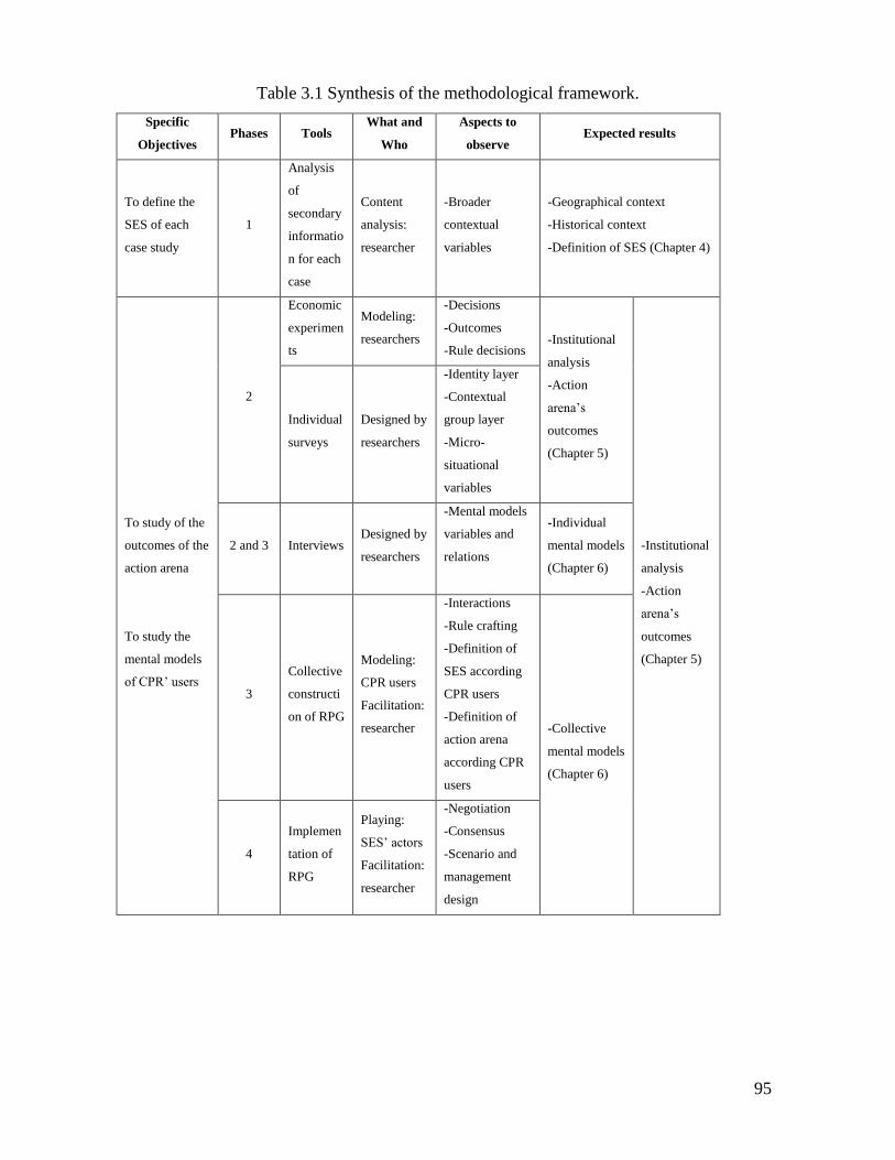
95
Table 3.1 Synthesis of the methodological framework.
Specific
Objectives Phases Tools
What and
Who
Aspects to
observe Expected results
To define the
SES of each
case study
1
Analysis
of
secondary
informatio
n for each
case
Content
analysis:
researcher
-Broader
contextual
variables
-Geographical context
-Historical context
-Definition of SES (Chapter 4)
To study of the
outcomes of the
action arena
To study the
mental models
of CPR’ users
2
Economic
experimen
ts
Modeling:
researchers
-Decisions
-Outcomes
-Rule decisions -Institutional
analysis
-Action
arena’s
outcomes
(Chapter 5)
-Institutional
analysis
-Action
arena’s
outcomes
(Chapter 5)
Individual
surveys
Designed by
researchers
-Identity layer
-Contextual
group layer
-Micro-
situational
variables
2 and 3 Interviews Designed by
researchers
-Mental models
variables and
relations
-Individual
mental models
(Chapter 6)
3
Collective
constructi
on of RPG
Modeling:
CPR users
Facilitation:
researcher
-Interactions
-Rule crafting
-Definition of
SES according
CPR users
-Definition of
action arena
according CPR
users
-Collective
mental models
(Chapter 6)
4
Implemen
tation of
RPG
Playing:
SES’ actors
Facilitation:
researcher
-Negotiation
-Consensus
-Scenario and
management
design
96
3.2.1 Phase 1: Definition of the SES
Phase 1 was carried out using secondary information about each one of the case
studies. On one hand, information about the biophysical characteristics such as geology,
physical geography, and natural ecosystems was collected and analyzed to understand the
natural context. On the other hand, information about the social system was analyzed with
emphasis in the relations of local population with the natural system. According the
conceptual framework of chapter 2 the time is a fundamental variable for the social
ecological systems, therefore, this information analysis is done in a historical perspective.
The result is a SES’ characterization that allows a concrete definition using (Ostrom, 2009)
‘s framework for the analysis of sustainability of SESs. Consequently, for each case study,
the conclusion synthetizes the context in terms of possible shocks, and a concrete definition
of the SES using the multitier framework proposed by Ostrom.
3.2.2 Phase 2: Field Experiments
The approach used in this research includes economic experiments as integral part
of the modeling and learning process. Through experimental economics it is possible to
explore the motivations and behavior of individual decision-making and, to analyze how
institutions and rules of the game influence the individual rationality when facing a
dilemma of cooperation between common pool resources users. The experiments used in
this project has been designed to tackle the role of ecosystem dynamics complexity on
individual decision making in common pool resources dilemmas as well as rule preferences
and its effects in their management. The experiments used in this research have been
designed in the framework of the project “Dynamic of Rules in Commons Dilemmas”
presented in the introduction of the dissertation. Cardenas et al. (in press) describe the
experiments and preliminary findings. The authors propose a new generation of
experiments that include the dynamics of the resources in the study of social dilemmas and
natural resources problems. The experiments designed in the context of the project
introduce in the experimental design several elements: a) the resource dynamics over time,
b) decisions that comprehends not only effort allocation but spatial, and c) provision and
appropriation problems (Ostrom, 1990). Expected outcomes of the experiments were
information about individual actions, earnings, rule preferences, rule compliance, resource
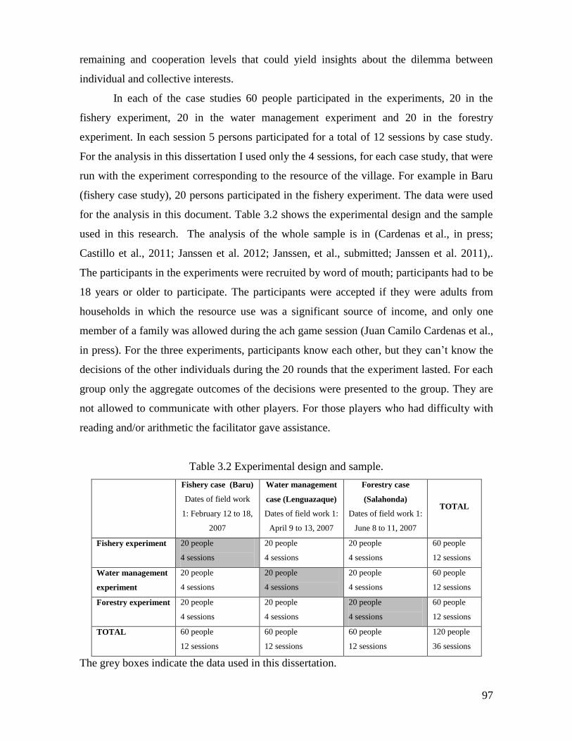
97
remaining and cooperation levels that could yield insights about the dilemma between
individual and collective interests.
In each of the case studies 60 people participated in the experiments, 20 in the
fishery experiment, 20 in the water management experiment and 20 in the forestry
experiment. In each session 5 persons participated for a total of 12 sessions by case study.
For the analysis in this dissertation I used only the 4 sessions, for each case study, that were
run with the experiment corresponding to the resource of the village. For example in Baru
(fishery case study), 20 persons participated in the fishery experiment. The data were used
for the analysis in this document. Table 3.2 shows the experimental design and the sample
used in this research. The analysis of the whole sample is in (Cardenas et al., in press;
Castillo et al., 2011; Janssen et al. 2012; Janssen, et al., submitted; Janssen et al. 2011),.
The participants in the experiments were recruited by word of mouth; participants had to be
18 years or older to participate. The participants were accepted if they were adults from
households in which the resource use was a significant source of income, and only one
member of a family was allowed during the ach game session (Juan Camilo Cardenas et al.,
in press). For the three experiments, participants know each other, but they can’t know the
decisions of the other individuals during the 20 rounds that the experiment lasted. For each
group only the aggregate outcomes of the decisions were presented to the group. They are
not allowed to communicate with other players. For those players who had difficulty with
reading and/or arithmetic the facilitator gave assistance.
Table 3.2 Experimental design and sample.
Fishery case (Baru)
Dates of field work
1: February 12 to 18,
2007
Water management
case (Lenguazaque)
Dates of field work 1:
April 9 to 13, 2007
Forestry case
(Salahonda)
Dates of field work 1:
June 8 to 11, 2007
TOTAL
Fishery experiment 20 people
4 sessions
20 people
4 sessions
20 people
4 sessions
60 people
12 sessions
Water management
experiment
20 people
4 sessions
20 people
4 sessions
20 people
4 sessions
60 people
12 sessions
Forestry experiment 20 people
4 sessions
20 people
4 sessions
20 people
4 sessions
60 people
12 sessions
TOTAL 60 people
12 sessions
60 people
12 sessions
60 people
12 sessions
120 people
36 sessions
The grey boxes indicate the data used in this dissertation.
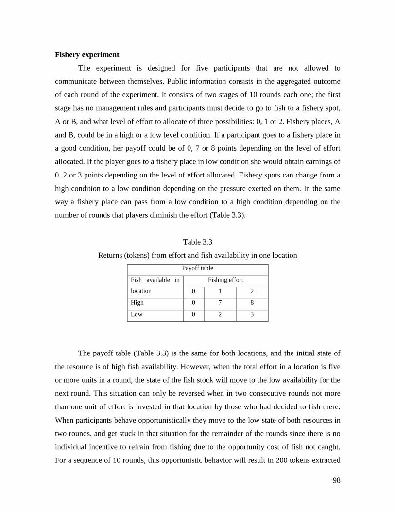
98
Fishery experiment
The experiment is designed for five participants that are not allowed to
communicate between themselves. Public information consists in the aggregated outcome
of each round of the experiment. It consists of two stages of 10 rounds each one; the first
stage has no management rules and participants must decide to go to fish to a fishery spot,
A or B, and what level of effort to allocate of three possibilities: 0, 1 or 2. Fishery places, A
and B, could be in a high or a low level condition. If a participant goes to a fishery place in
a good condition, her payoff could be of 0, 7 or 8 points depending on the level of effort
allocated. If the player goes to a fishery place in low condition she would obtain earnings of
0, 2 or 3 points depending on the level of effort allocated. Fishery spots can change from a
high condition to a low condition depending on the pressure exerted on them. In the same
way a fishery place can pass from a low condition to a high condition depending on the
number of rounds that players diminish the effort (Table 3.3).
Table 3.3
Returns (tokens) from effort and fish availability in one location
Payoff table
Fish available in
location
Fishing effort
0 1 2
High 0 7 8
Low 0 2 3
The payoff table (Table 3.3) is the same for both locations, and the initial state of
the resource is of high fish availability. However, when the total effort in a location is five
or more units in a round, the state of the fish stock will move to the low availability for the
next round. This situation can only be reversed when in two consecutive rounds not more
than one unit of effort is invested in that location by those who had decided to fish there.
When participants behave opportunistically they move to the low state of both resources in
two rounds, and get stuck in that situation for the remainder of the rounds since there is no
individual incentive to refrain from fishing due to the opportunity cost of fish not caught.
For a sequence of 10 rounds, this opportunistic behavior will result in 200 tokens extracted
99
by the group. However, if they were to coordinate their efforts, the cooperative solution
leads to 382 tokens by spreading the effort equally and alternating over the two fishing sites
so that at least two people do not exert the maximum effort. Experimental literature in the
study of CPR has demonstrated that communication between individuals lead to a higher
probability to solve the commons dilemma without third party intervention or externally
imposed rules (Ostrom et al. 1994). In contrast, there is no clear understanding how
experience with resource management would affect those choices of rules and its effect on
cooperation in a common dilemma; therefore we decided to include this type of treatment
instead of communication in line with objectives regarding the research. In small scale
fisheries social dynamics can lead to conflicts among fishers breaking communication and
affecting organizational capacity, consequently generating suboptimal outcomes. The main
reason for banning communication in the experiment had to do with the focus of the
project, and given the experimental results reported in the literature mentioned above, we
wanted to isolate preferences and behavior regarding rules. Communication between
participants with the rest of the villagers was not tracked once they had left the room.
Monetary incentives and conversion of tokens into money were calculated in such a way
that each participant could earn, in average, the equivalent to one labor day - 8 USD.
The second stage of the experiment starts with a presentation of three management
rules that they can vote in order to play another 10 rounds with the elected rule. The three
rules are designed to solve the commons dilemma and they simulate a property rule, a
lottery rule and a rotation rule. The three rules are designed to solve the commons dilemma
and they simulate: 1) random access, 2) rotation and 3) quota rule. If two rules were tied, an
additional round of votes between those two candidates was used to solve the tie. The first
round after the election had the same starting situation as round 1 of the experiment. As we
mentioned before, after ten rounds the participants could vote for one of the following three
rules:
· Rule 1 (Random access): In each round the location where each of the participants
is allowed to fish is randomly determined by rolling a dice. If a participant
harvested in a location not permitted, a roll of a six of the dice led to paying back
the harvested points.
· Rule 2 (Rotation of Access): In each round one of the locations is banned from
fishing. A in rounds 1 and 2 and B in rounds 3 and 4, etc. If a participant is caught
100
fishing illegally, also with a one-sixth (1/6) probability of inspection, the harvested
amount had to be returned.
· Rule 3 (Quota of effort): Each participant can exert an effort of 0 or 1 per round
regardless of the site they have chosen. In the case of a participant putting in two
units of effort, again with a probability of one-sixth (1/6) of being inspected, the
participant had to return back the harvested amount.
Details about experimental design and results are reported in (Cardenas et al., in
press). The protocol and forms of the experiment can be found in the Appendix I. The costs
of breaking the rules were calculated according to the most common penalty for small-scale
fisheries, which is the confiscation of the yield. If four of the players exert an effort of 1, in
fishery spots in high condition, and one of them breaks, for example the quota rule,
choosing an effort of 2, the group earns 36 tokens; and if the offender is inspected a fine is
applied and the collective losses in one round represent 22.3% of the total payoffs of the
group. In general, the fines range regarding collective losses and are between 20 and
27.3%. Besides, the monitoring probability of one-sixth is much higher than the actual
possibilities of environmental authority, at least in the case studies. Therefore, the cost of
breaking any of the rules is a strong incentive to cooperate (Castillo et al., 2011).
The participants were recruited via word of mouth and flyers hung throughout the
village inviting participants of 18 years and older to participate. Special effort was made to
recruit adults from households engaged in the resource extraction of that village. Only one
member of a family was allowed during the same session. At the end of the series of
experiments a handful of people were identified for in depth interviews. Those individuals
were selected among the participants to be a representative sample of the community. At
the end of the week, a session was organized to discuss the experiments.
Forestry experiment
This experiment is designed for five players that harvest a forest with a maximum
carrying capacity of 100 units. The resource is explicitly represented in a magnetic white
board. Each tree is a token with a green tree drawing. The initial amount of the resource has
maximum amount of 100 trees. In each round the participants can take a maximum of 5
trees from the resource (Table 3.2). The stock will regenerate each round. For every 10
trees remaining in the resource, one tree is added as regrowth, with a maximum of 100
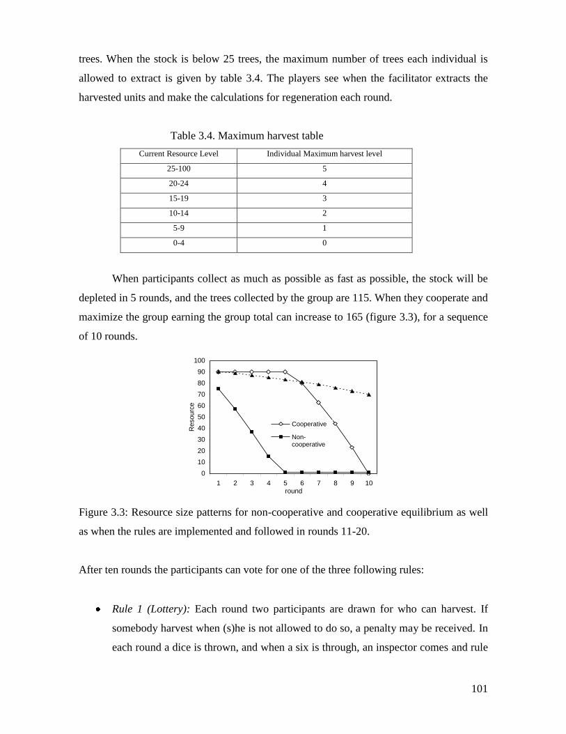
101
trees. When the stock is below 25 trees, the maximum number of trees each individual is
allowed to extract is given by table 3.4. The players see when the facilitator extracts the
harvested units and make the calculations for regeneration each round.
Table 3.4. Maximum harvest table
Current Resource Level Individual Maximum harvest level
25-100 5
20-24 4
15-19 3
10-14 2
5-9 1
0-4 0
When participants collect as much as possible as fast as possible, the stock will be
depleted in 5 rounds, and the trees collected by the group are 115. When they cooperate and
maximize the group earning the group total can increase to 165 (figure 3.3), for a sequence
of 10 rounds.
Figure 3.3: Resource size patterns for non-cooperative and cooperative equilibrium as well
as when the rules are implemented and followed in rounds 11-20.
After ten rounds the participants can vote for one of the three following rules:
Rule 1 (Lottery): Each round two participants are drawn for who can harvest. If
somebody harvest when (s)he is not allowed to do so, a penalty may be received. In
each round a dice is thrown, and when a six is through, an inspector comes and rule
0
10
20
30
40
50
60
70
80
90
100
1 2 3 4 5 6 7 8 9 10round
Resourc
e
Cooperative
Non-cooperativeRules
102
breakers get a penalty. The penalty consists of paying back the harvested amount
plus extra 3 tokens.
Rule 2 (Rotation): A fixed schedule is defined which two participants are allowed to
harvest each round are able to harvest. In round 1 A and B can harvest, then C and
D, then E and A, etc. The same mechanism of monitoring and sanctioning is used as
rule 1.
Rule 3 (Property): Everybody has the right to harvest 0, 1 or 2 units per round. If a
higher amount is harvested, a dice determines whether the participant is caught,
pays back the harvest plus 3 tokens.
Participants can vote for their preferred rules, which will be implemented in a
subsequent series of rounds if three or more players vote for it. If two rules get two votes,
an additional round of votes between those two candidates is used to determine the final
chosen rule. All rules are aimed at solving the resource dilemma by regulating the over
extraction of the resource in the appropriation stage, and thus achieving the goal that the
resource lasts all ten rounds and each of the five players have an equal share of the resource
over the duration of the game.
Ten rounds are played with the new rule implemented. The first round after the
election has the same starting situation as round 1 of the experiment. If participants would
be selfish and rational the non-cooperative equilibrium would be the same. The reason for
this is that breaking a rule would result in a lower expected penalty than can be derived
from breaking the rule. For rules 1 and 2 the expected penalty for breaking a rule is 8/6
while gaining 5 tokens if one is not allowed to harvest. For rule 3 the expected penalty is
again 8/6 but this time the gain is 3 tokens. Due to receiving penalties, the expected group
earnings in the non-cooperative equilibrium is reduced to 95 for rules 1 and 2, and 81 2/3
for rule 3. The expected level of penalties for rules 1 and 2 is equal to 3 players each round
have a 1/6 probability being caught and pay 8 (5+3) tokens for the first four rounds and 6
(3+3) for the last round before the resource is depleted. This leads to an expected penalty of
20 tokens. For rule 3 5 players have each round the risk of being caught. This leads to an
expected penalty of 33 1/3 tokens.
If the rules are followed the resource size declines slowly. Since the resource is not
fully depleted when the experiments end the total earnings are 100 trees for all three rules.
This is higher than the Nash equilibrium. If a group was able to coordinate to increase it’s
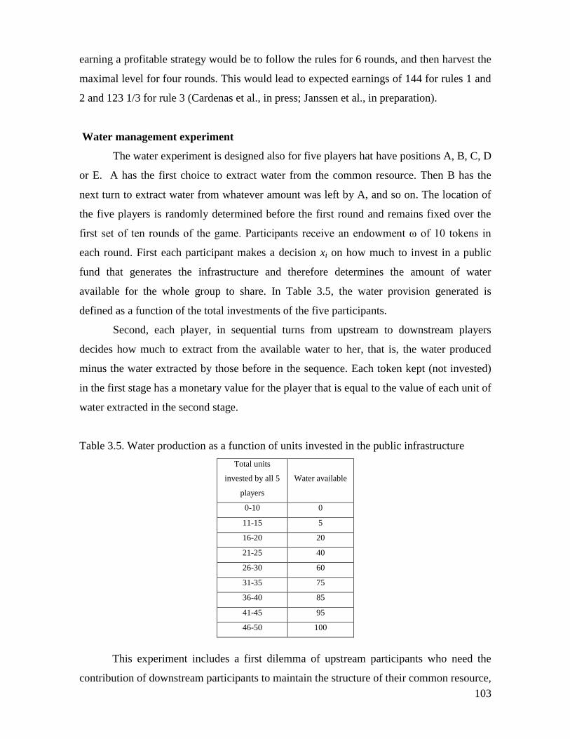
103
earning a profitable strategy would be to follow the rules for 6 rounds, and then harvest the
maximal level for four rounds. This would lead to expected earnings of 144 for rules 1 and
2 and 123 1/3 for rule 3 (Cardenas et al., in press; Janssen et al., in preparation).
Water management experiment
The water experiment is designed also for five players hat have positions A, B, C, D
or E. A has the first choice to extract water from the common resource. Then B has the
next turn to extract water from whatever amount was left by A, and so on. The location of
the five players is randomly determined before the first round and remains fixed over the
first set of ten rounds of the game. Participants receive an endowment ω of 10 tokens in
each round. First each participant makes a decision xi on how much to invest in a public
fund that generates the infrastructure and therefore determines the amount of water
available for the whole group to share. In Table 3.5, the water provision generated is
defined as a function of the total investments of the five participants.
Second, each player, in sequential turns from upstream to downstream players
decides how much to extract from the available water to her, that is, the water produced
minus the water extracted by those before in the sequence. Each token kept (not invested)
in the first stage has a monetary value for the player that is equal to the value of each unit of
water extracted in the second stage.
Table 3.5. Water production as a function of units invested in the public infrastructure
Total units
invested by all 5
players
Water available
0-10 0
11-15 5
16-20 20
21-25 40
26-30 60
31-35 75
36-40 85
41-45 95
46-50 100
This experiment includes a first dilemma of upstream participants who need the
contribution of downstream participants to maintain the structure of their common resource,
104
which is crucial for the production of water in the game. However, the downstream
participants can only obtain benefits from the resource if upstream participants avoid the
temptation to deplete the common resource and leave little water for downstream players.
Under this asymmetric game, participants first experience a provision dilemma in
the contributions stage, and then face a resource appropriation dilemma when they extract
from the generated resource. The earnings of the participants are the result of contribution
and extraction decisions, and the resulting payoff for each player from adding the extracted
tokens plus the tokens they keep from the initial endowment in each round.
Due to the shape of the production function, no analytical formulation can be
derived. However, we can calculate the Nash equilibrium and the cooperative equilibrium
numerically. If participants were rational self-interested individuals nobody would invest in
providing the infrastructure in the first round. Since the upstream participant is expected to
collect the whole resource, downstream participants will not invest. For participant A there
is no benefit to invest when others don’t. If this is the reasoning of the participants in the
last round of experiment we find via backward induction that the same happens for all
earlier rounds. Thus, the Nash equilibrium for this game is that no one invests and all
receive 10 tokens for group earnings of 50 tokens.
To define the cooperative solution we calculate the maximum amount of the
infrastructure plus tokens not invested. There are multiple social optimum outcomes. For a
41 tokens investment, a resource of 95 tokens is generated, and for a 46 tokens investment a
resource of 100 tokens is generated in each round. The total earnings of the group in the
cooperative solution amounts to 104 tokens, doubling the social earnings of the Nash
equilibrium. After instructions and practice rounds, the participants play for 10 rounds
under a baseline treatment. After the 10th
round, three different rules are presented for
choice by the participants:
Rule 1: Each round, after participants have contributed to the maintenance of the
irrigation system, and the size of the water available is announced, the order in
which one can take water for irrigation will be assigned randomly to participants.
Rule 2: There will be a fixed rotation in which one can collect water. This order
is a 5 round rotation system: ABCDE, BCDEA, CDEAB, etc.
Rule 3: Each of the participants has a right of 20% of the water of the irrigation
system. This amount is calculated after the available water is announced. The
order to extract water remains the same for all the rounds: ABCDE. A dice is
105
thrown in each round. When 6 is thrown, an inspector arrives and will check the
water extraction. The participant pays back the extra amount taken, and an extra
amount of 6 units if more than 20% is taken.
Each participant can vote for their preferred rules, which will be implemented in a
subsequent series of rounds if three or more players vote for it. If two rules get two votes,
an additional round of votes between those two candidates is used to determine the final
chosen rule. The three rules are effectively a lottery in access to water, a rotation in access
to water or a maximum legal water quota. All rules are aimed at solving the resource
dilemma by regulating the over extraction of the resource in the appropriation stage, and
thus achieving the goal that each of the five players has an equal share of the resource over
the duration of the game.
Ten rounds are played with the new rule implemented. The first round after the
election has the same starting situation as round 1 of the experiment. Before the participants
receive their payments, they fill out a general survey on their demographics and resource
use within the village. The duration of an experimental session was about 3 hours and the
typical earnings of the participants was worth between one and two days of labor (Cardenas
et al., in press; Janssen et al., in press)
Individual surveys and Semi-structured interviews
Interviews and individual surveys were designed to apply after the experimental sessions to
each player. The survey details are in the Appendix 2. The variables that we wanted to
inform with surveys are guided by the micro situational variables proposed by Poteete et al.
(2010) and discussed in chapter 2, and by the identity and group context layers of
information that Cárdenas and Ostrom (2004) identified as brought by people to CPR
experiments in the field. The Identity layer of information includes: wealth, occupation and
experience; other regarding preferences; values about external vs. self-governance; gender,
age, education and skills; and, membership to civic organizations. On the other hand, the
group context layer information contains: shared norms, heterogeneity and inequality;
group identity and cooperative or competitive setting. In addition to that, after the
experiments participants are asked to answer a brief survey bout their opinions of the three
rules. Furthermore, during the experimental fieldwork five people were selected among
participants in the experiments to carry out semi-structured interviews about CPR
106
management and institutional topics. During the second field phase a second group of
participants in the role playing construction and experiments were interviewed (10 per case
study) with the aim of understanding mental models of resource users. These interviews
were designed according the insights from the conceptual state of the art of chapter 2. The
work of (Abel et al., 1998) provided important practical recommendations for the
elaboration of the questions.
3.2.3 Phase 3: Collective construction of a role-palying game (RPG)
The third phase was the co-construction of a role play game having as a departure point the
economic experiments designed by the researchers (Cardenas et al., in press). The co-
construction of a role game refers to the fact that a group of participants in the experiments
along with researchers design and test a game with the objective, set collectively, of discuss
and negotiate rules of use of the common resource. A next step is to implement the role
game with relevant stakeholders and with the designers as observers along with researchers.
The role game allowed observing mental models, interactions, conceptualization of the SES
from the perspective of resource users, to understand what are the key variables of the
problems are for participants and observe collective processes of rule crafting.
The objective of the RPG was set with people according to their needs in terms of
their problematic regarding resource management. A second objective was to understand
mental models of participants regarding the experimental context and possible relations
with the real system. Our hypothesis was that people were going to modify three groups of
possible variables in the RPG that in experiments were simplistic: 1) resource settings, 2)
individual decisions, and 3) collective decisions like rule negotiation, sanctions or inclusion
of new roles. One of the aims of this process was to allow, “collective learning” about
resource management. Collective learning means to say the least, a point of view exchange;
it can also become concrete decision-making. The field phase of the third part of the search
was carried out in Barú island (fishery case) from April 24 to 28, 2008 with 18 persons, in
Salahonda (forestry case) from June 16 to 20, 2008 with 19 persons and Lenguazaque
(water management case) from May 23 to 30, 2009 with 20 participants. The co-
construction of the role game was carried out through the following steps:
Step 1: Feedback and discussion of experimental results
107
The purpose of this first step was to carry out a discussion about experimental
results with participants, and to make a linkage with RPG construction. Another objective
of this phase was to understand: what kinds of variables were relevant for participants in
the experiments; what were the most relevant relations between variables; and discuss their
rule preferences and reasons for that. Therefore, a workshop was organized. We reminded
the mechanisms of experiments and presented the results of the analysis of experimental
data to participants. The facilitator made a synthesis of the experiments. Next, a
presentation of the results was done in an interactive format. The idea was that people
helped to understand their reasons for their decisions and the links participants do with their
real production system. At the end, the idea of co-construction was announced in order to
represent more concrete and realistic the CPR problematic in each case study. By the end of
the workshop a group of about 10 people, who represented about half of the attendants to
the feedback workshop, were invited to work in the design of the new game (RPG). The
agenda for this step is shown in the table 3.6.
Table 3.6 Agenda for the workshop on a discussion of experimental results
1 Presentation and objective
2 Introduction of the participants
3 Fishery/Forestry/Irrigation game
3.1 How does the game work?
3.2 How did people play?
3.3 What if everybody were selfish?
3.4 What is the game solution?
3.5 Lessons from the game
4 Can we improve the game?
The purpose of this first step (items 1 through 4 in Table 3.6) was to carry out a
discussion about experimental results with participants, and to link them with the RPG
construction. Another objective of this phase was to identify the variables relevant for
participants in the experiments, the most relevant relations among variables, and discuss
their rule preferences and reasons for them. The facilitator reviewed the experiments,
followed by a presentation of the results in an interactive format. This allowed
understanding their decision-making reasoning and the links participants perceived with
their real production systems. At the end, the proposal for co-construction was announced
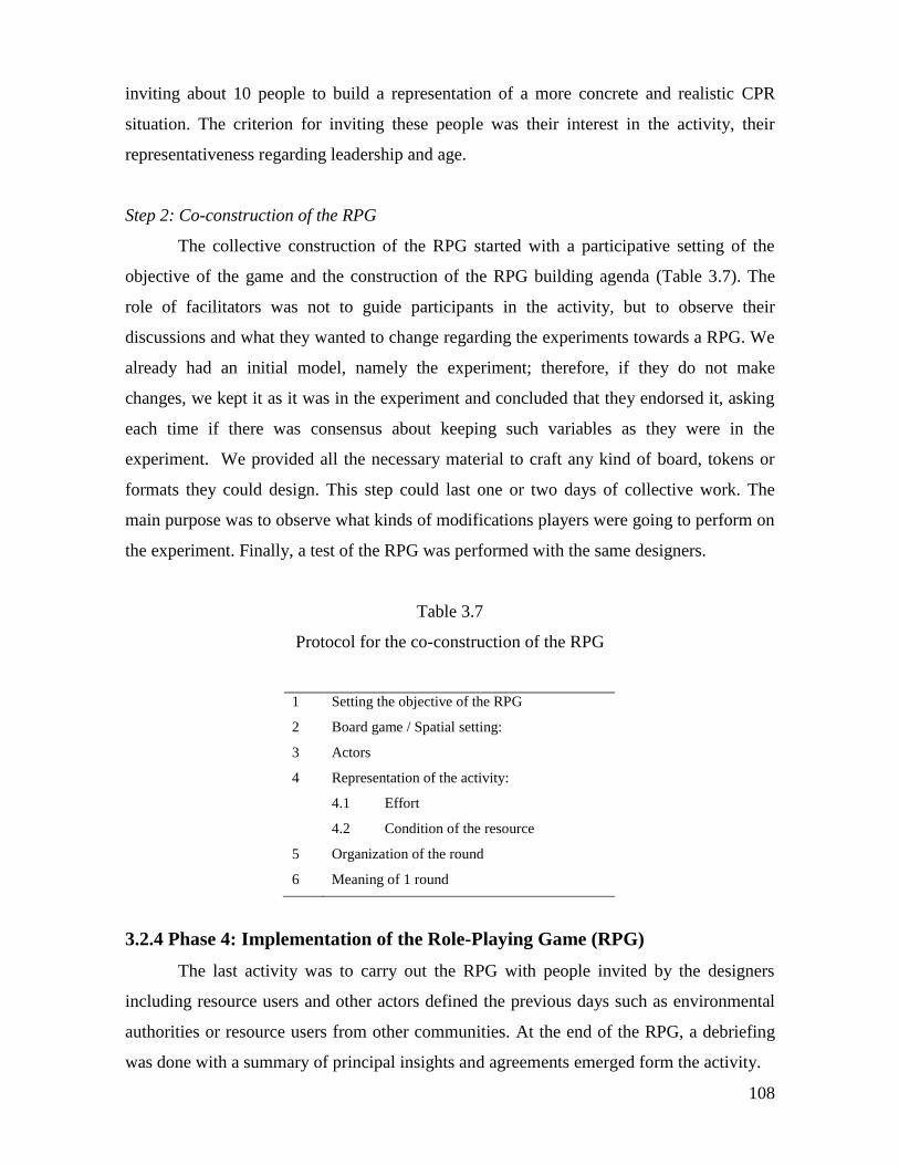
108
inviting about 10 people to build a representation of a more concrete and realistic CPR
situation. The criterion for inviting these people was their interest in the activity, their
representativeness regarding leadership and age.
Step 2: Co-construction of the RPG
The collective construction of the RPG started with a participative setting of the
objective of the game and the construction of the RPG building agenda (Table 3.7). The
role of facilitators was not to guide participants in the activity, but to observe their
discussions and what they wanted to change regarding the experiments towards a RPG. We
already had an initial model, namely the experiment; therefore, if they do not make
changes, we kept it as it was in the experiment and concluded that they endorsed it, asking
each time if there was consensus about keeping such variables as they were in the
experiment. We provided all the necessary material to craft any kind of board, tokens or
formats they could design. This step could last one or two days of collective work. The
main purpose was to observe what kinds of modifications players were going to perform on
the experiment. Finally, a test of the RPG was performed with the same designers.
Table 3.7
Protocol for the co-construction of the RPG
1 Setting the objective of the RPG
2 Board game / Spatial setting:
3 Actors
4 Representation of the activity:
4.1 Effort
4.2 Condition of the resource
5 Organization of the round
6 Meaning of 1 round
3.2.4 Phase 4: Implementation of the Role-Playing Game (RPG)
The last activity was to carry out the RPG with people invited by the designers
including resource users and other actors defined the previous days such as environmental
authorities or resource users from other communities. At the end of the RPG, a debriefing
was done with a summary of principal insights and agreements emerged form the activity.
109
3.3 Conclusion
In this chapter I have presented and discussed the methodological approach to address the
main research question of this study namely: “What is the relation between mental models
of common pool resources’ users and the institutional arrangements to manage the common
resources?” In chapter 2 I built a conceptual approach that provided the three specific
objectives needed to answer the research question: to define the SES of each case study, To
study of the institutional arrangements and the outcomes of the action arena in each case
study, and investigate the mental models of CPR’ users. In short, the methodological
proposal combines experimental economics and ComMod approaches. To develop these
questions a set of three case studies have been selected, each one represents an important
CPR situation: fisheries, water and forestry. The following chapter develops the first
specific objective by providing a geographical and historical context that allows to define
the SES of each case study.
110
4 GEOGRAPHICAL AND HISTORICAL CONTEXTS
Formal and informal institutions that human groups develop in order to relate with
natural resources, and in a more broad perspective with ecosystems they live in, are no
static prescriptions. Institutions are a construct that evolves along with social collectives
and, in the case of the relation with ecosystems; they may or may not evolve with them.
Rules and norms are part of the strategies that society develops for adapting to change. As
Ostrom (2005) states “Rules can be thought of as the set of instructions for creating an
action situation in a particular environment […]Rules combine to build the structure of an
action situation”. Human groups face action situations and produce outcomes constantly,
this dynamics produce, on one hand, a given territorial construction, and, on the other, a
history of Socio Ecological Systems (SES). In the three case studies of this research, there
are particular territorial constructions that have evolved through time as part of the history
of each of the SES studied.
The previous statement is based on a conception of the territory in line with cultural
geography, in which, “The territory is not only a material form of spatial organization, it is
also what each individual does … The territory is the spatial expression of a person or a
group’s membership to a terrestrial portion” (Deneux, 2006: 170 - my translation).
According Deneux, the geographers that differentiate space from territory (Brunet, Le
Berre and others), define territory as one of the faces of the geographic space, the one that
has the historical marks of the development (mises en valeur), and the one that expresses
the social appropriation of the space; “In a space, nature “would produce” the landscapes,
while societies “would produce” the territories.” (Deneux, 2006: 170 – my ranslation).
This conception is in tune with the geography concerned on behavior that express
belonging forms, development and space exploitation (Deneux, 2006). The Dictionaire
Critique of geograqphy (Brunet et al.,1993), express appropiately the essence of this
conception of territory: “The territory is to the space, what the class consiouseness is to the
class … The notion of territory is therefore, at the same time, juridical, social and cultural,
111
and affective. The territory implies always the space appropriation: it is different to the
space ”.
The Socio Ecological System (SES) notion has the same relevance in this study.
These systems are composed by social and ecological coupled systems that are adaptive
complex systems. Social systems include governance issues such as property rights and
access to natural resources, knowledge systems regarding ecosystems, resource use, ethic
visions about the relation between society and nature, culture and economic dimensions.
And the ecological system refers to self regulated organisms interacting with their
environment (Berkes et al., 2003.). I enpasize the coupled aspect of the SESs in terms of a
strong and direct human dependence on the CPR, fisheries, forest and water for each one of
the case studies. I quoute the ecosystem’s concept according the Assessment Millenium
Ecosystem Assessment Synthesis Report (2005), which is relevant for this research:
“An ecosystem is a dynamic complex of plant, animal, and microorganism
communities and the nonliving environment, interacting as a functional unit.
Humans are an integral part of ecosystems. A well-defined ecosystem has
strong interactions among its components and weak interactions across its
boundaries. A useful ecosystem boundary is the place where a number of
discontinuities coincide, for instance in the distribution of organisms, soil
types, drainage basins, or depth in a water body.”
In order to complement the definition in terms of processes Levin (1999) in Westley
et al. (2002) states that the ecosystem components “interact in such a way that a dynamic
set of processes produces a complex and diverse set of structures. The interaction is
described as self-organizing- that is, structure and processes mutually reinforce each
other”. The ecosystem exists in a space and constructs a territory. The spatial dimension,
localization and form of the space where the different systems exist is important, as well as
its physical limits.
The geographical dimension is then fundamental to understand the action situation.
If the aim is to understand institutional arrangements, and mental models regarding them,
then it is essential to go to the history of SESs. This geographical and historical context is
an attempt to place a picture of the SESs, as we observe it today in a more complex collage.
A geographic and temporal collage that could explain the why of actors, positions,
agreements, behaviors, and beliefs that have given shape to the rules that this particular
human group has for its relation with the nature, in this case a common-pool resource. This
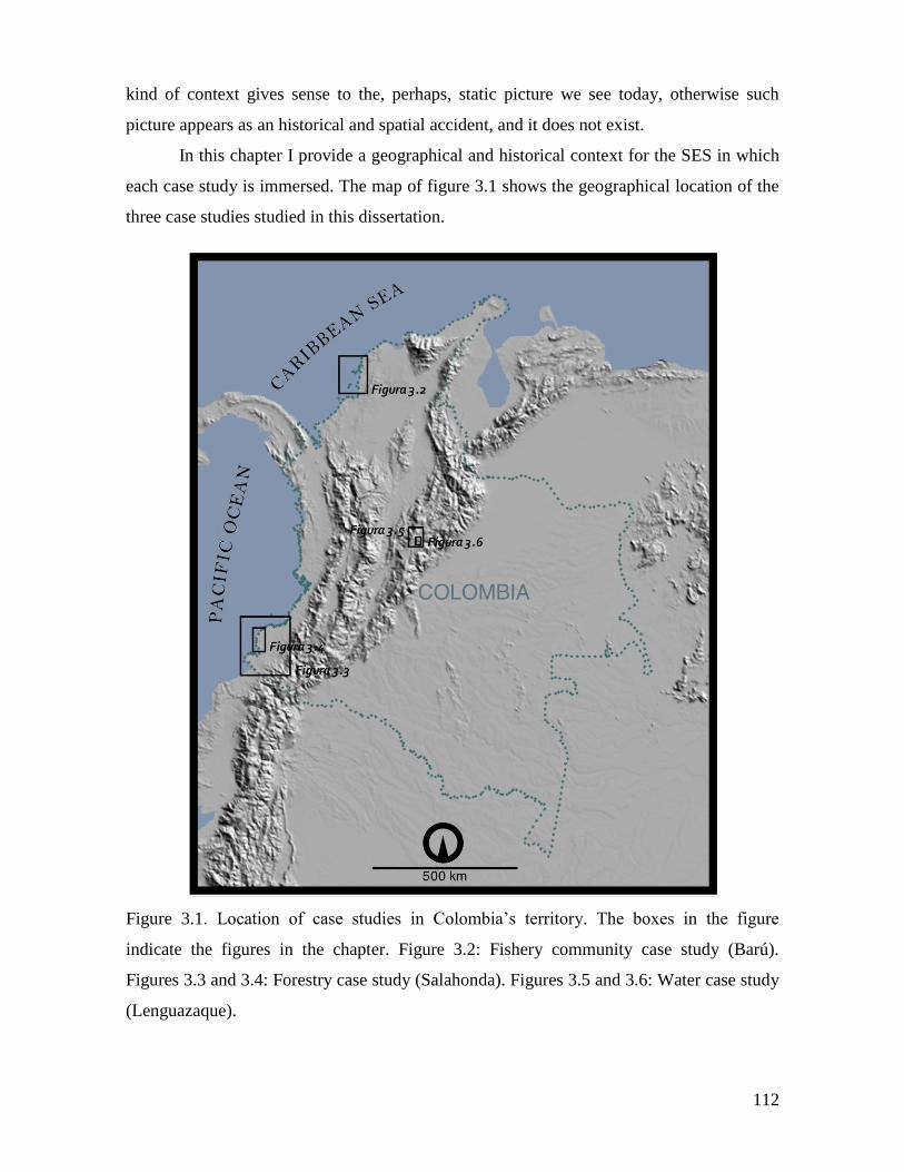
112
kind of context gives sense to the, perhaps, static picture we see today, otherwise such
picture appears as an historical and spatial accident, and it does not exist.
In this chapter I provide a geographical and historical context for the SES in which
each case study is immersed. The map of figure 3.1 shows the geographical location of the
three case studies studied in this dissertation.
Figure 3.1. Location of case studies in Colombia’s territory. The boxes in the figure
indicate the figures in the chapter. Figure 3.2: Fishery community case study (Barú).
Figures 3.3 and 3.4: Forestry case study (Salahonda). Figures 3.5 and 3.6: Water case study
(Lenguazaque).

113
4.1 Fishermen community of Isla Barú
Fishermen community is a social group that has lived in a particular geographical zone for
decades. The spatial and biophysical characteristics of this environment have shaped this
human group but also they have influenced the natural environment. The culture that has
developed in this area has produced a dynamics in institutional arrangements that have
determined the way this society interacts with the ecosystem.
In the next paragraphs I provide a regional geographical context as a way to
facilitate the understanding of the problem addressed by this study. Figure 1 shows the
geographic location of Isla Barú and Islas del Rosario Archipelago.
4.1.1 The Coastal Colombian Caribbean region
The fishermen community chosen as case study lives in the village of Barú located in the
island of Barú in the C{Citation}olombian Caribbean coast. The region, far from being a
homogeneous territory comprehends a number of different geological settings, ecosystems
and socio-cultural human groups and histories. The area has the highest coastal mountain
(5.775 meter above sea level), Sierra Nevada de Santa Marta, a vegetation that ranges from
tropical sub desert zones to humid tropical forests. This territory comprehends also 320.000
hectares of wetlands flooded permanently and 900.000 hectares flooded during six months
each year. The Colombian Caribbean is localized in the northern area of South America, in
the equatorial strip, where there are climatologically different conditions due to the ocean
that surrounds the region as well as the trade winds from northeast. The landscape is
characterized by a number of small scale hill ranges, from the minor foothills of the western
Colombian mountain range, to the north east part of La Guajira peninsula. What is
considered the Colombian Caribbean is composed by sea, coast, continental land, insular
areas and it is a gathering space of flora, fauna and people coming from the north, the
isthmus and from the south. It is a region of compulsory transit towards the Caribbean or
towards the Andes (Zambrano 2000), in the words of the same author, the Colombian
Caribbean region is a space of cultural, social and biological gathering. The territory is
shared by several indigenous groups and, according Abella (2001), there are at least eight
types of cultural areas in the region. Costeños (people who lives in the coast border),
114
sabaneros (people from the savannas), montañeros (people from the hills), people from the
river, cachacos (Andean people), guajiros (people from the Guajira peninsula), indigenous
people and islanders. They are Caribbean people not due to their cultural affinities but
because of their capacity of assimilation of new cultures which is the Caribbean principal
cultural characteristic (Abella 2001). Fishermen from Barú, most of them descendents of
African slaves, belong to the group costeños mentioned by Abella.
4.1.2 The biophysical environment
The Colombian Caribbean region has 132.244 km2
of terrestrial territory, 44 km2
of insular
lands and 536.574 km2
of marine area, for a total of 668.862 km2.
The coast has about 1560
km from Cabo Tiburon (8º 40’ N, 77º 20 W) in the border with Panama to the mouth of
Sillamana River (11º 50’ N, 71º 25’ W), border with Venezuela. The region comprehends,
in addition to its coastal lands a wide area of marine areas with several islands, keys and
fishing-grounds located between Central America coast and the Antillas Menores separated
by a deep basin called the Colombia Basin. The Economic Exclusive Zone area4 is about
288.000 km2.
(PNNC 2006).
Geomorphologic and Geological setting
The coastal region could be described by a number of physiographic units, from east to
west, The Guajira Peninsula, Northern foothills of the Sierra Nevada de Santa Marta,
Magdalena River Deltaic Complex, The Central Caribbean Coast and the Uraba Gulf
(Zambrano 2000)
Isla Baru belongs to the Central Caribbean Coast, as described by Zambrano (2000),
in physiographic terms; this zone is marginal as well as convergent due to its closeness and
parallelism to the boundaries of the tectonic plates that surround it. It includes the hill
4 “The concept of the exclusive economic zone is one of the most important pillars of the 1982 Convention on
the Law of the Sea. … It consists of: a twelve-nautical-mile territorial sea; an exclusive economic zone of up
to 200 nautical miles in which coastal states have preeminent economic rights and which obviates the need
for a territorial sea of 200 nautical miles claimed by some states; extension of the continental shelf regime to
the margin, with revenue-sharing obligations beyond the exclusive economic zone; a regime for transit
passage through straits used for international navigation and for archipelagic sea-lanes passage; guaranteed
access to and from the sea for land-locked states; a regime for the administration and development of the
common heritage resources of the international sea-bed area; protection and preservation of the marine
environment; and adequate mechanisms for settlement of disputes concerning the interpretation and
application of the provisions of the Convention.” (FAO, 1987)
115
Ranges of San Jacinto, San Jeronimo and Luruaco. In this zone, the Sinu River has its
mouth, and the Canal del Dique also pours its waters into the sea. These characteristics of
micro mountain ranges and hydrological regimes generate a high variety of complex
ecosystems which allow differential management regimens. The island of Barú is located to
the southwest of Cartagena city. In the southwest tip of the island we found the village of
Barú, essentially a fishermen settlement. Isla Barú is considered part of the archipelago of
Islas del Rosario and Barú. This group of islands and coral reefs is considered as the richest
and most important coral reef formation of the Colombian continental Caribbean region
(Prahl and Erhardt 1985).
The surface of the Caribbean coast can be described geomorphologically by four
types of landscapes: 1) the cliffs 2) inherited marine and riverine terraces 3) deltas and 4)
mosaic of landform of Caribbean coast (IDEAM 1996). One of the landscape units of this
mosaic is the landscape of small hills, which is constituted by a series of elongated
separated by a hydrographic network moderately dense. Its morphogenetic environment is
depositional, but currently is erosional. Isla Barú is located in this landscape of small hills.
Formally, the cartographic unit is called Unit of Barú and Tierra Bomba Hills (Cbt), which
hills have no more than 50 MSL (meters above sea level), they have short slopes, convex of
low inclination; an intermittent and incipient drainage network of subdendritic pattern, and
wide bottom valleys. The erosive characteristics are associated to the scarce vegetation due
to de hydrologic deficit of the area (IDEAM 1996).
The Islas del Rosario archipelago and Isla Barú are located southwest of Cartagena
with a total area of 1573 km2, 22.5% of emerged lands and 75.1% of coral reefs of recent
formation with, less than 10.000 years (IGAC 2002). The archipelago is composed by a set
of islands, keys and coral barriers spread with an east-west direction around the two major
islands, Isla Grande and Isla Rosario. These islands are marine terraces of +3 m. bordering
with reef lagoons of depths until -25 m. (IDEAM 1996). Isla Barú is a Miocene formation
of eroded clay and limestone and filled by Pliocene and Pleistocene material modeled
afterwards by the marine transgressions of recent Quaternary. The islands are constituted
by a series of small hills of maximum height of 50 MSL in Barú (IDEAM 1996).
Isla Barú and the village of Barú are in the border of the National Natural Park
Corales del Rosario y San Bernardo. The northwest border of the Park is 45 km southwest
from Cartagena de Indias. The Park is, in essence, a marine protected area of about 1200
km2, with coral reefs as one of the most important ecosystems, several islands, coastal
116
lagoons, mangrove forests, tropical dry forest, rocky and sandy coasts and phanerogamous
prairies. This is the territory where fishermen of Barú develop the artisanal fisheries
activities, therefore it is important to give a brief description of the marine geomorphology
which determines the spatial places where the marine fauna allows to establish the fishery
spots or “bajos” as they are known locally.
Cendales et al. (2002) carried out a geomorphological and ecological study of Islas
del Rosario and Isla Barú which is taken as basis for this description. The zone is a reef
complex of islands and coralline banks. These banks are the fishery spots and they are
located inside the Natural Park. The coralline formations are over abrasion limestone
terraces that surround the islands. There are also, isolated from the islands, coral banks. The
study defined 5 geomorphologic units: 1) emerged zones, 2) terraces, 3) fringing reefs, 4)
banks and 5) soft bottom
The marine area of the Colombian Caribbean region is in the Caribbean tectonic
Plate, and the terrestrial portion is in the South American Plate. The region is composed by
rock formations ranging from the Proterozoic (1300 Million years), in the mountain massif
of the Sierra Nevada de Santa Marta, to recent times, arranged in complex superimposed
geologic structures due to successive tectonic, sedimentary and volcanic events. The
Colombian marine platform is composed by islands and archipelagos of coralline origin
with low relief. The coast lines are formed by mangrove forests associated to estuarine
environments, coastal lagoons and sandy and muddy beaches.
Locally, the area is located in the so called Sinu Belt composed by sedimentary
rocks interpreted as deposits from marine and coastal environments. The ages of these
sedimentary formations, presents in Isla Barú, are from the Paleocene epoch (50 million
years in average) to Recent. Today, the island is formed by beds of Miocene-Pliocene (from
20 to 2 million years old) beds of mudstone, quartz sandstone from Pleistocene (2 million
years), reef limestone with abundant fossil contents of corals and mollusks from
Pleistocene and beach deposits from Holocene (Present) (Reyes et al. 2001). This
configuration is the result of Miocene eroded formations of mudstone and limestone filled
by Pliocene and Pleistocene material modeled by marine transgressions during the
Holocene. The resulted landscape is a series of small hills with maximum heights of 50
meters above sea level. The area is affected by current marine streams and sediments from
Magdalena River and the so called Canal del Dique (IDEAM 1996).
117
Climate
The Colombian Caribbean region is under the influence of the North-South displacement of
the Intertropical Convergence Zone (ITCZ). The ITCZ is a low pressure belt located
between the subtropical regions of the North and south hemispheres. Its main effect on the
zone is the existence of two main seasons: dry and humid, and strongly influenced by the
Trade Winds. In areas where the ITCZ’ zone of low pressures is displaced in the equatorial
line about 10 º N, such as the Caribbean, the Trade Winds that cross the Equator from the
Southern hemisphere modify their direction towards the West. The Earth rotation
movement diverts the Trade Winds towards the West; therefore, the ITCZ generates strong
and uniform Trade Winds from the Northeast over the entire Caribbean basin.
Colombian Caribbean zone is influenced by the trade winds which blow from
Northeast to Southwest with higher intensity from December to April generating a summer
period or a non-rainy period due to their dryness. During the Northern hemisphere summer
season the anticyclone that produces the Trade Winds moves towards the north and they
stop, allowing the normal atmosphere stratification in the Caribbean. This situation
produces the characteristic Caribbean rainy season with small rain peaks during May and
June and its higher intensity in October and November. In spite of this general condition the
Colombian zone has a high variety of precipitation regimes in the zone from an average of
250 mm in the Guajira Peninsula to the North, 500 mm in the central portion to 2000 mm in
the Urabá zone towards the southwest.
The particular climate in the area of Isla Barú is a Tropical Semiarid type with two
well defined year periods: humid rainy season and dry or windy season. The main
characteristic is a water deficit period during the first 3 or 4 months of the year and the
most important dry period towards middle of the year. Its annual average temperature is
240C (PNNC 2006).
The temperature in Isla Barú oscillates between 31.50C and 24.2
0C, the annual
termic amplitude is less than 50C according to the meteorological station of Cartagena
(IDEAM). The higher temperature values of 330C are registered during the month of May
and the lowest during the months of December and April. Because of the cloudiness the air
temperature tends to decrease towards an average monthly of 27.90C and 28.6
0C (CIOH
1993). The relation between the precipitation and the temperature produces a dry season
during February and March and a higher precipitation during the period August-November
with a maximum in the month of October.
118
The direct localization in the sea of Isla Barú generates a high humidity regime
almost constant oscillating between 78 and 86%. The minimum values occur during the dry
season and maximum values for the rainy season from April to November with a short
interruption during the months of June and July (PNNC 2006). The humid seasons are
intense with frequent precipitations which absolute values generally are over 100 mm and
the dry season is characterized by the absence of precipitation due to the increase of
condensation of water steam as an effect of the heating of humid soils and covered by
vegetation. The precipitations are variable in quantity and distribution, with an average
annual precipitation about 993 mm from which the 93% falls during the period from April
to November.
The yearly average of precipitation is 993 mm. There are three characteristic
precipitation periods during the year. A dry period from December to April with average
values of 12.10 mm/month. An intermediate period from May to August with an average of
99.5 mm/month. And a rainy season from September to November with an average of 154
mm/month. These averages are based in a database from 1970 to 2001 made by Martinez
from the Central de Pronósticos Meteomarinos del CIOH.
Ecosystems
The region of Islas del Rosario and Isla Barú area is composed by a set of terrestrial and
marine ecosystems, in this section a description of both will be provided. The intention is
not to give a detailed and exhaustive explanation of their components and processes,
instead of this, I intend to give a general description of the ecosystemic structure of the area
that is taken from the natural park management plan 2005-2009 (PNNC 2006).
- Coastal and Terrestrial Ecosystems
In this section are included the terrestrial vegetal formations as well as estuarine areas,
deltas and coastal lagoons. The ecosystems described are 1) Tropical dry forest 2)
Mangroves and 3) Coastal lagoons.
1) Tropical Dry Forest. The vegetal covertures in these islands are limited by the high
superficiality of soils, high erodability and high carbonate concentration. The forests in
islands are classified as Tropical Dry Forest and Mangroves. In the ecosystem of Tropical
119
Dry Forest there are three types of vegetation: xeromorphic structure5 (Xerophytia),
mangroves (Halohelophytia) and beach formations (Psammophytia). The fauna associated
to this ecosystem is mainly of reptile species, from aquatic to terrestrial species, such as
turtles, the Boa constrictor, crocodilian reptiles (Caimán crocodrilus), lizards such as
iguanas (Iguana iguana) and other minor species. Turtle species are of special interest
because its environment comprehends open sea, coral reef shallow lagoons and beaches
where they deposit the eggs. According Becerra et al (1998) in PNNC (2006) inhabitants of
the islands reports that turtles were abundant in the past but today they are very scarce. The
main species is the hawksbill turtle (Eretmochelys imbricada) which is classified as
critically endangered according the World Coservation Union (IUCN). People use to hunt
them and sell their meat and eggs in Cartagena in spite of the illegality of this practice. Bird
species are of paramount importance for conservation in the islands because they are places
for nesting of several species. Islanders say also that bird population was much more
abundant and diverse in the past. The decrease of vegetal covertures due to human
deforestation has occasioned this loss of biodiversity.
2) Mangroves. In Islas del Rosario the mangroves are located in the south part
(leeward) frequently associated with coastal lagoons. Isla Barú has a mangrove belt in the
coastal area and subxerophytic vegetation inland. Towards the inland the island presents
subxerophytic vegetation. Mangrove ecosystem is home of terrestrial and aquatic
organisms from marine as well as fresh water dominium. Gastropods, bivalves, oysters,
crustaceans, bryozoans, tunicate and sponges species live in the roots system of the
mangroves. This vegetal formation offers a number of ecosystem goods and services. These
formations have been affected by anthropic exploitation in order to build infrastructure and
also the necessity to clear zones in order to offer lands to buyers from outside the islands.
Until recent years still people practiced intensive logging for fuel or coal elaboration, but
5 A xerophyte or xerophytic organism (xero meaning dry, phyte meaning plant) is a plant which is able to
survive in an ecosystem with little available water or moisture, usually in environments where potential
evapotranspiration exceeds precipitation for all or part of the growing season. The typical morphological
consequences of these adaptations are collectively called xeromorphisms. D. J. Taylor, N. P. O. Green, G. W.
Stout (2001). Biological Science 1 & 2, third edition. Cambridge University Press.
120
this activity has diminished due to the propane gas availability. In the mangrove zones,
people use to collect oysters but its cutting generated an increasing scarcity of the mollusks.
3) Coastal lagoons. Coastal lagoons are important ecosystems that offer important
environmental services such as buffer for perturbations, nutrients recycling, refuge habitats
of several organisms. These ecosystems have communication with the sea permanently or
during certain seasons, they serve as communication, for several species, between the sea
and mangrove ecosystem. In addition, these lagoons, due to its landscape beauty are used
as recreation places during tourism activities.
- Marine Ecosystems
The marine ecosystems of the islands are 1) Sedimentary bottoms 2) Rocky coast 3)
Beaches 4) Sea grass and 5) Coral reefs.
1) Sedimentary bottoms. They are located five meters below surface level, in the infra-
littoral zone until the break point of the continental platform. They present grain textures
such as sandy, clay and silt which are the home place for several biological organisms
(benthonic communities). Several authors (Vega-Vélez 1980, and Levinton 1995 in Steer
Ruiz et al. 1997) have found low primary productivity of these benthonic communities and
it depends of the organic matter present in the water column transported from another
ecosystems. This ecosystem has an important role in the recycling process of nutrients,
biological control and food production. Several organisms of commercial importance for
the artisanal fishery such as mollusks, fish species and crustaceans like shrimps are part of
this ecosystem.
2) Rocky coast. This ecosystem is composed by biologic communities living on rocky
substrates in the tidal zone. These platforms usually form rocky cliffs and they have
developed from hard calcareous platforms, from ancient coralline formations, emerged due
to earth crust movements. These types of ecosystems occur in zones of high energy due to
waves and intense sea currents which determine the type of organisms. These organisms are
principally algae communities and invertebrates, mollusks and crustaceans of commercial
importance.
3) Beaches. In general the islands present coralline sandy white beaches. In some
sectors they are accompanied by mangrove patches. Crustaceans, mollusks, birds and
reptiles are part of these ecosystems. Particularly the hawksbill turtle (Eretmochelys
imbricada) and some bird species use some of them as nesting places. This ecosystem is of
particular economic importance due to its principal attractiveness for tourism.
121
4) Sea grass. This ecosystem is composed mainly by vascular plants that carry out
their life cycle under salted water or a mix between fresh and sea water, also named marine
phanerogams (mainly Thalassia testudinum). Important areas of macro-algae (Halimeda
incrassata, Penicillus spp and Rhipocephalus spp) are part of the ecosystem. The maximum
depth in the zone is of 30m at which it is possible to find them, they reach their maximum
development at less than 10 meters depth and over sandy substrates in highly illuminated
and calm waters. They carry out a number of important ecological functions such as, food
production, high productivity, offering of substrate for epiphytes fixation, recycling of
nutrients and sediments stabilization. In the Caribbean, they are one of the most important
ecosystems of coastal and marine zones, and for this reason they are considered as one of
the five strategic ecosystems for the country, as well as coral reefs, mangroves, rocky
littoral and sedimentary bottoms (PNNC 2006). The marine phanerogams are dominant
components of the submarine landscape in some areas, and they serve as refuge for a
considerable number of fish in larval and juvenile states. The major extensions of this
ecosystem are found towards the south of the islands. These prairies surround completely
some of the islands and occupy a big percentage of the coral banks. They occupy an area of
835 hectares. In Isla Barú they are present along 13 km of its northern coast.
5) Coral reefs. These ecosystems are the submarine landscapes that have been
modeled and dominated by the geomorphological and ecological processes of coralline
formations. They are the ecosystem more diverse, biologically more complex and
productive of the planet, and perhaps one of the more fragile. The current coral formations
have established about 5000 years ago over tertiary reef platforms. A set of ideal climatic
and marine conditions are present in the area for the development and permanency of this
ecosystem: warm temperatures between 20 and 290C, clear water, low depth (less than 50
m), high salinity (33 to 36 ppm), a protected geographic position and influenced by the
Trade Winds, and short and low energy waves. These conditions have allowed the
formation of the most important coralline ecosystem of the coastal Colombian Caribbean.
These organisms are characterized by a very high productivity; therefore they are not
located in zones of high discharges of sediments. Their 3D structure provides a complex
structure of micro environments with different types of luminosity, currents, nutrients and
oxygen concentration. As a consequence they serve as habitats for a high number of species
as well as a refuge place for fish from open oceans from depredators and as a resting place.
122
In the area there are 16 ecological units of coral reefs that could be mapped. They are
different among themselves due to substrate nature, biotic components and characteristic
elements of fauna and flora. The coralline ecosystems occupy an approximate area of 145
km2, and are located in the Northeast of Isla Barú, around Islas del Rosario and forming
several banks in the continental platform close to the coast. Cendales et al. (2002)
established seven ecologic units for coralline area, each one characterized by the
predominance of a coral gender6. The coral reef ecosystem is of paramount commercial
importance in the area because is in the coral banks where are localized the most important
fishery spots where fishermen from Barú develop their main economic activity.
4.1.3. Barú: The social system
The geographic character of Islas del Rosario and Isla Barú has been modeled not only by
climatic and biophysical aspects; population processes, cultural inheritance, economic
activities and institutional dynamics have played a fundamental role in the configuration
and dynamics of the current Islas del Rosario and Isla Barú social-ecological system.
Population
In order to understand the present situation of the fishermen community of Barú Island it is
relevant to know the origin of such human group and its relation with the ecosystem they
live in. The way they understand and relates with the fishery resource is necessary the result
of a history that starts with pre Hispanic mixed with European and African practices. In this
section, a brief overview of this history is presented.
Pre Hispanic population
The reconstruction of the history of human settlement in the Caribbean region faces a
number of problems, according to Zambrano (2000): a) the human groups that lived in the
region before the arrival of the Spaniards had no writing. Therefore, it is impossible to
compare the observations of the chronicles of Europeans whose descriptions where more an
6 These units are: 1) Millepora-Palythoa 2) Acropora palmate remains 3) Montastrea spp. With remains of
Acropora cervicornis 4) Porites porites 5) Agaricia tenuifolia 6) Montastrea spp. 7) Agaricia spp. with
Montastrea franksi. 8) Mixed unit and 9) Soft bottom with vegetation (Thalasia prairies) and minimum
presence of coral.
123
attempt to justified the conquest and the dominium strategies used with the American
natives. b) Another source of information is the record of the population census made by
the Spaniards. But they were made late, and were made in populations already modified by
the Spaniards; their way of life was modified as a function of Spaniards needs, they
relocated the native settlements, the tribes were merged and the land use patterns were
modified, among others. c) Regarding the material vestiges left by native Caribbean human
groups, the archaeological research still does not offer a clear view; furthermore the
archaeological research in Colombia has given more importance to archaeology of sites
than a contextual archaeology (Zambrano 2000).
There is very few information specifically about the region of Barú. The presence of
human population in the Colombian Caribbean archipelagos, close to the coast dates back
to times before Columbus. In the Spaniards conqueror’s chronicles the aboriginal settlers
they found in these lands where from the Mocanas culture that belonged to the Karib
family, whose livelihoods where derived from mollusks collection and fishing (PNNC
2006). According to CINEP (1998) “The mocaná of Karib language, who crossed the sea
in big canoes, where magnificent sailors, they had an abundant population…they mainly
cultivated. Their principal food was the corn”. According Zambrano (2000) in the
Caribbean Colombian Coast, by the discovery time, the groups were Calamares o Turbacos
from the Karib family.
Dolmatoff (1989) (in Zambrano 2000) gives a more complex description of the pre
Hispanic inhabitants. This author, based on archaeological evidence, states that, through
thousands of years several cultures consolidated themselves by taking advantage of the high
coastal ecological potential. They were cultures that developed a way of life supported in
the dependence of the sea fauna as source of proteins, and the cropping of roots, mainly
yucca, the use of palm trees, hunting of small preys and the collection of mollusks. The
corn agriculture was not practiced in South America until the first millennium B.C., coming
from Mesoamerica (Zambrano 2000). According Zambrano (2000) there is a consensus
about a correlation between the introduction of corn and a change in the social organization
towards a more complex type of society. Before corn introduction the type of societies were
organized as tribes, more or less egalitarian where hierarchical relations were temporal and
not associated to lineage, and the work division were associated to a primary sexual
differentiation. While the population increased, the cropping of corn solved the food
124
necessities and changed the technologies and labor division promoting the chiefdoms7
which implied a hierarchical society with different classes of people. At the arrival of
Spaniards most of the indigenous groups in the Colombian Caribbean coast had evolved to
the chieftainship social organization. In 1492, the Karib family was one of the exceptions to
this pattern in terms of corn dependency. Instead, it was characterized by the dependency of
the yucca crop, with corn as a more marginal product and a lineal geographic distribution
along the sea coasts and rivers.
The Conquest in Barú
Since the discovery of America, the Caribbean and particularly Cartagena region
was the entrance of Europeans and Africans to the current Colombian territory, which
triggered the human crossbreeding and ecosystem transformation that has given shape to
the current territorial and ecosystem configuration.
In 1501 Rodrigo de Bastidas arrived to Cartagena harbor, Islas de San Bernardo
archipelago, Islas del Rosario archipelago and Isla Baru (Siegert 2006). He meets
inhabitants from Isla Barú and left records about his encounters with them, from which we
know that the human groups settled in the zone were Bahaire-Baru, Coco-Polonia and
Baricuica- Baricuica, usually they carried the group name taken from their chief (PNNC
2006). In 1533 the Spaniard commandant Pedro de Heredia founded Cartagena in Calamarí
Island where there already was an indigenous settlement (CINEP 1998) from the Karib
group. Isla Baru was considered part of the rural area of Cartagena that became the center
of military expeditions during Spanish conquest. In 1538 the Spanish king gave his
authorization for the distribution of indigenous among the neighbors, meaning, Spaniards
already settled in the rural regions. In this form, Cartagena and its rural surroundings
became a colonial society of “encomenderos”8 . The harbor became more important due to
its protected characteristics and its closeness with Panamá.
7 Cacicazgo or caciquismo in Spanish
8 “In colonial Spanish America, the granting of Indian people as slaves to individual conquistadors (settlers)
by the Spanish crown. The system was based on the assignment of Moorish villages to members of the
military orders in medieval Castile, but was revived in the colonies from 1503, with the idea that native
labour was exchanged for protection. Abuses led reformers such as Bartolomé de las Casas (1474–1566) to
call for its abolition. It declined slowly after 1550, being replaced by repartimiento, another system of forced
labour.” The Free Dictionary. By Farlex. Web site: http://encyclopedia.farlex.com/Ecomienda
125
African population
Between 1576 and 1592 Spaniards discovered the first gold mines in the Nueva
Granada. Spain was facing a difficult situation in Nueva Granada, the socio-political and
territorial structures of indigenous population were fragmented and there were an
indigenous demographic crisis due to war, epidemics and forced labor. The slavery became
the solution for the replacement of indigenous labor force.
Cartagena de Indias became the main slavery port of Spanish America until 1640.
According to Del Castillo-Mathieu (in Maya 2004), most of Africans brought to America
and particularly to Cartagena came from the Bantús or Angolas ethnic groups between
1580-1640, between 33 to 50% of slaves were from this origin. According Del Castillo-
Mathieu cited in Maya (2004) the calculated number of slaves entered through Cartagena
de Indias was of 169.371 in the period from 1580 to 1640.
During the first half of 17th
century the predominant cultural African groups present
in Cartagena were the Bantús which had their origins in valley of the Congo River, an
environment of equatorial forest where they developed a style of life based on cereal
agriculture and the intensive utilization of iron (Maya 2004).
From 1640 to 1703 Spain lost the control of slaves’ trade due to the war with
Portugal and the general decadence of the Spanish Kingdom, this activity was carried out
illegally by Dutch merchants. During this period the Cartagena slave provision was from
Curazao Island where the Dutch traders brought the slaves from center West Africa. As a
consequence there were a dominium of slaves from the Benin Gulf of Ewé-fon culture,
particularly a group called Ararás. During this period it has been calculated that Cartagena
should have received a similar number of slaves than Lima, 20.000 and the entire Peru,
30.000 persons, without counting the illegal traffic from Dutch traders (Maya 2004).
Between 1703 and 1740 the slave commerce was dominated by France and
England. Until 1713 “The French Company of Guinea” basically bought the slaves to
Dutch merchants in Curazao. From 1714 to 1740 the English Company “South Sea
Company” introduced 30.000 slaves in Cartagena. In these years the presence of Ewé-fon
culture began to decline and it was replaced by people coming from the Biafra Gulf.
According to Del Castillo in Maya (2004) the first half of 18th
the black people from
126
Guinea rivers have disappeared in Cartagena while Carabalíes from the Biafra Gulf began
to arrive massively. The decline and final of slavery commerce took place from 1740 to
1810 (Maya 2004).
The models of society, culture, economies and the way in which African groups
brought to America from 16th
to 18th
centuries definitively marked the construction of
territory and the relation with ecosystems of Afro Colombians communities until 21th
century.
Cartagena became one of the main ports of the New World and Spanish farms with
their slave population were established in Isla Baru. Slaves who managed to escape from
Spaniards gathered in small villages called “palenques” where today, there are the villages
of Santa Ana, Baru and Ararca. Coconut economy was of main importance in Isla Barú
from late 19th
to early 20th
century. This product was sold in Cartagena. Towards 1949 the
coconut crops suffered from the “porroca”, a worm who attacks the crops, marking the end
of this agricultural success (Siegert 2006). Regarding specifically the settlement in Isla
Barú, the first known record dates back from 1777 consisted in a letter from people settled
in the north part, to the Spaniards authorities in Cartagena asking for permission to move to
the south. In 1839 Barú village appears as a parish church with 673 inhabitants and a
reference of their activities such as fishing, agriculture and sailing. In 1889 Isla Barú is
formally recognized as an administrative territory (corregmiento) and in 1919 their legal
spatial limits are set (PNNC 2006). There are no evidences of permanent settlements in
Islas del Rosario before XX century, only since 1950 some fishermen from Isla Barú settled
in the islands and carried out activities of coconut agriculture in addition to artisanal
fisheries. During the 70s arrived accommodated families from Cartagena and the interior of
the country and built holiday houses and the islands began to be known as an important
touristic place (PNNC 2006).
Duran (2007) characterizes the history of Barú village and Rosario Islands during
20th
century with three periods: 1) the insertion in Cartagena’s market, and in the Caribbean
illegal trade, 2) the drug smuggling, and 3) the tourism. The author calls these periods, the
“Prosperity epochs” which have marked the history during the 20th
century. The first period
was based in the agriculture of coconut palm and other products, and the trade of other type
of products, mainly electrical domestic appliances. Thanks to these economic activities,
mainly the agriculture, several families developed and increased their wealth. But this
epoch finished towards the middle of the century due to a coconut palm plague, as
127
mentioned above. According Duran (2007) this period marked the entering into modernity
of this society. The local economy passed from self consuming and barter patterns to an
intensive production model, mainly coconut. At the same time Barú was linked to the
Caribbean commercial circuits and the illegal traffic of products such as electric appliances
was an important activity.
An important consequence of the declining of coconut agriculture was the
establishment of the first foreigners, from Cartagena elite, mainly to the islands. Local
people abandoned their plantations and sold their lands, and native people began to work as
domestic employees and guards of these new owners receiving very low wages. Toward the
late 70s Cartagena started a process of popularization of the tourism, and the flow of people
from the interior of the country increased. The islands became the place for Colombian
high elite holidays, including the presidential family. This status triggered the arrival to the
islands of drug smuggling capitals during late 80s and 90s. Local people benefited
economically of this situation due to the labor market distortion that these capitals
produced; it was much more money for the same kind of jobs they were use to, in the same
type of servant work. According interviews to local people, in Duran (2007), natives affirm
that that was the best epoch because the population really beneficiated economically from
the “narcos”. As I mentioned the touristic business in the zone has been almost the most
important economic activity since the late 70s.
According Duran (2007), “Prosperity epochs”or economic peaks are seen, by local
people, as external phenomena that generates social changes and economic benefits, but
right after the good period arrives the crisis. The “good times” leave their long term
consequences, now the cost of life is higher, as the elder natives say “there is more money
but less food” (Duran, 2007:16 – my translation).
4.1.4 Barú today
Barú became an island in the 16th century when Cartagena was interested in finding a
fluvial communication with the Magdalena River, which was the only connection with the
Andes and the rest of the new territories. The aim was to take advantages of a zone with a
set of riverine wetlands. The first evidences of fluvial-terrestrial traffic date back from 1571
between Cartagena and Magdalena River.
There are two perceptions about the territory of Barú, on one hand, the local
inhabitants’ territorial model, and on the other hand, the administrative and tourists
128
operators’ model. According to the first, the territory has an urban center, which is Barú
village, and the rest, including the islands is the rural agricultural periphery. In fact Barú
inhabitants consider the islands as an integral part of their territory, and locally they call
them as “Islas de Barú” (Barú Islands) (Durán, 2007). For the second territorial perception,
Barú island’s urban settlements; Ararca, Santa Ana and Barú are the places where the
natives live, and the rural zones where the touristic installations are established, and the
where the wealthy people from Cartagena and the interior of the country have their luxury
houses. The Rosario Islands are a separate entity in which the National Park rules, tourist
operators work and also foreign people has properties. The state, at the same time,
considers most of the rural zone as “empty reserved national lands”9, fact that has been
source of conflict with other actors, this will be explained below.
According PNNC (2006), today there is no reliable information about the
population of Baru Island and it is possible to find different figures from different sources.
Cardique (2001) reports a change in Isla Barú population from 5.000 to 6.000 inhabitants in
the period 1981-1996. The study from CIOH-Cardique (1998) gives a figure of 9.734
inhabitants distributed in this way; Barú village 6.240, Santa Ana: 2.731 and Ararca: 763
inhabitants (PNNC 2004). The Land Use Plan document of Cartagena (2001) (in PNNC
2004) establishes as a main population growth driver the vegetative growth and gives
especial emphasis to the emigration of young people towards Cartagena in search of better
labor conditions. Fishermen population is about 100 inhabitants of Afro Colombian origin
with low incomes and high poverty indexes. They allocate their workforce, mainly, to
artisanal fishing. In the village, 33% of inhabitants do not allocate their time to any
economic activity though they are capable of that. The unemployment levels generate
social problems and a high pressure on natural resources (PNNC 2004).
Barú village community is a relatively homogeneous population in terms of socio
economical aspects; most of the population derives its income from fisheries and tourism
sector. Islas del Rosario population is about 600 persons (Durán, 2007) and they belong to
the same families that people from Barú village. During the first half of the 20th
century
there was a peak of agricultural trade with Cartagena and Panama represented mainly by
the coconut monoculture. Several families which descendants are present today in Barú
village and the islands, beneficiated from these activities and they became the most
9 “baldíos reservados de la nación”
129
prestigious such as the Gómez, De la Rosa, Morales, Molina, Vargas, Geles and Medrano
(Durán, 2007). As an important fact, in order to understand social organizations in the
zone, is that the community of the islands, whose main settlement is called Orika, is now
organized as a Communitarian Council in order to claim territorial rights, according the
Law 7010. People from Barú are in the process of becoming a different Communitarian
Council. This fact is relevant because one of the important problems in Barú, is the land
property conflict between the state, external owners and native population.
Since the late 19th
century natives have used the lands for agriculture, but at the
same time the state has considered the rural territory as “empty reserved national lands”11.
These are the same lands that, since the fifties, have been occupied by wealthy people from
Cartagena and touristic operators. One of the consequences was that many people have
been hired for low wages in hotels and private houses during years. Since 1984, all these
lands are in a legal dispute, because they have been claimed by the state. In 2006, the first
land expropriations were carried out by the state, and the lands were given to the natives of
the islands, at the same time that the conformation of the Islands Communitarian Council
was in the conformation process. However, still the Colombian government does not
recognize the ancestral presence of Afro - Colombians in the zone. The allocation of the
expropriated lands was done because of the legal written evidence of property rights from
the first half of twentieth century (Durán, 2007). As a consequence, people from Barú
village started an organizational process in 2007 in order to organize the Comunitarian
Council of Barú.
Economic activities
Artisanal fishery and tourism are the main economic activities in the islands which depend
completely from the ecosystems of the area. According the Natural Park management
document (PNNC 2006) these activities contribute to the constant pressure on the hydro-
biological resources of the zone, and it qualifies them as overexploitation of the resources.
Ecosystems such as coral reefs, sea grass prairies and mangroves offer food and protection
to fish larvae, crustaceans and mollusks of high commercial interest, and the same
10 The Law 70 is explained in detail in the forestry case study section.
11 “baldíos reservados de la nación”
130
ecosystems are the habitat of many of these species in their adult stage (INVEMAR et al.
2003 in PNNC 2006).
Fisheries
Islas del Rosario and Isla Baru fishing areas are located in the South west of
Cartagena bay, in central zone of the Caribbean Colombian continental coast in the
surroundings of Isla Grande (10º 11’ N y 75º 48’ W), to the East Periquito island, to the
North Isla del Tesoro, to the West Isla del Rosario and to the South Isla Arena. The
coralline formations are located in the North East border of Isla Barú, surrounding Islas del
Rosario and forming several banks over the high relief of the continental platform. The
coralline area is about 145 km2. The emerged areas, Islas del Rosario, are 51,8 km
2 and
marine areas occupy 67,7 km2. According (PNNC 2006) the main fishery spot is an area
close to Isla Arena, one of the Islas del Rosario archipelago islands, but usually fishermen
move among spots looking for better caught. The fishery is mainly developed in the banks,
which have been named by local fishermen according to geographical places or dominant
species12. The most important fishery spots are La Botella, Bajo Largo, Punta Del Medio,
Las Palmas y Tortugas (see Figure 8)
In Islas del Rosario the purpose of the fisheries activity is self consumption,
commerce and sportive fishing. The 81% of the families are dedicated to the fisheries as a
first income activity followed by tourism activities. The fishing gear utilized consists in
nylon cord, harpoon, different types of local fishing nets, hooks for lobster capture, diving
and nasa (CIOH-Cardique 1998 in PNNC 2006).
The main species caught in the zone are, yellow mackerel (Caranx chrysos) red
snapper (Lutjanus spp), barracuda (Sphyraena spp.), and grouper (large genera:
Epinephelus and Mycteroperca). The most abundant species during the whole year are the
barracuda and yellow mackerel. In the last years touristic and fishing activities have
increased due to the lost of local people lands as a production factor. But the tourism
dedication is temporal and the main activity is the fisheries (PNNC 2006).
12 The names of the fishery spots according PNNC (2006) are: Pelota del Papá José, Mina Alta, Las Pelotas,
Tortuga, Las Picuas, Maravilla, Palmito, Bajo Patancoro, Zona de Pargo, Tío Sorda, Lapa de la Tortuga,
Lapa de la Cojinúa, Risco de Nando, Coco afuera, Las Nubes, Bajo El Medio, Bajo Fríjol, Bajo Bunne, Bajo
Rabio Ahorcado, Bajo Chara, Bajo Las Piedras.
131
In Baru village exists a fishermen organization called Pesbaru founded in 2002 with
24 fishermen as members (PNNC 2006), the main fishing gear utilized by people in this
organization are the nylon cord and harpoon. In average the organization buys to its
members 50 Kg of fish weekly and approximately 50% is sold in Cartagena. There are
other buyers who go directly to Barú (PNNC 2006). Fishermen have seen the decreasing in
the caught and an increase in the effort they have to do. According PNNC (2006) there are
two principal problems that affect fishermen from the islands: 1) the difficulties in
obtaining bait (carnada) due to the lack of appropriate equipment and 2) the industrial
fishery which is accused of been responsible for the collapse of a number of species due to
their highly harmful fishing techniques (trawl fishery in Spanish: pesca de arrastre) over
reproduction areas.
According INVEMAR (in PNNC 2006) the maximum extraction pressure has been
exerted on adult individuals of main species during reproductive season, which could affect
the recruitment (Hernández et al. 1997 in PNNC 2006). The same source reports a lack of
control in captures as well as absence of adults individuals according local population.
Hernandez et al. (1993 in PNNC 2006) shows an overexploitation of the resource, by that
time, which indicates that natural regeneration rate was low. Reported causes of this
situation are, according (PNNC 2006), the utilization of inappropriate fishing methods and
intensive exploitation due to the increase in fish demand during last 30 years. According
Becerra et al. (1998 in PNNC 2006) one of the more harmful fishery methods is the
dynamite, which utilization is not mentioned by fishermen, the authors affirm that it is the
most used in the natural park. One of the consequences of dynamite utilization is the
destruction of important coralline areas. Other highly damaging fishery gear is the trammel
net (trasmallo) also widely used. The general trend of the economic activity has been a
decrease in catch and a decrease in the stock of commercial species.
The Natural Park was created in 1997, and it has increased its area from 17.800 Ha
in 1977 to 19.506 Ha in 1988, and in 1996 to 120.00 Ha. Park’s headquarters are located in
Cartagena, but it has two other offices, one in Isla Grande and other in Isla Tesoro, these
are part of the Islas del Rosario. In Isla Tesoro there is the holidays’ house of the
Colombian President (Durán, 2007). The Park has around 20 functionaries, which include
professionals (biologists, social workers) and other type of workers whose task consist of
Park’s territory surveillance among other technical duties. Between 2000 and 2004 the
Park’s administration was carried out working closely to the local communities. Many of
132
the rules were agreed with local fishermen and, in general terms Park authorities had a good
relation with them (Fisherman interview, 10/07/2008). Even the internal rules of the local
fishermen association were designed according the Park’s proposals and the Ministry of
Environment Law (Fisherman interview, 4/07/08). In 2004 the central National Parks’
headquarters changed its policy and the director of the park was replaced by a military one.
This new administration changed its policies in terms of rule implementation towards
favoring the external imposition of the rules, and their strict application. As a consequence,
the relation with the community deteriorated and the previous administration’s work on rule
agreements and awareness has been lost. Currently, the general attitude of local inhabitants
towards the Park authorities is characterized by hostility, and prevention with any Park’s
proposal, situation that has led to conflicts, with fishermen in general, and specially with
the organization Pesbarú.
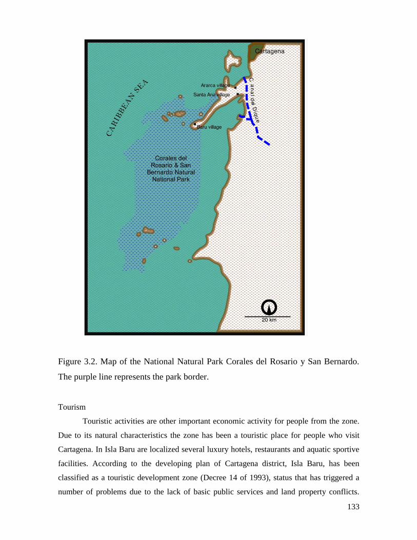
133
Figure 3.2. Map of the National Natural Park Corales del Rosario y San Bernardo.
The purple line represents the park border.
Tourism
Touristic activities are other important economic activity for people from the zone.
Due to its natural characteristics the zone has been a touristic place for people who visit
Cartagena. In Isla Baru are localized several luxury hotels, restaurants and aquatic sportive
facilities. According to the developing plan of Cartagena district, Isla Baru, has been
classified as a touristic development zone (Decree 14 of 1993), status that has triggered a
number of problems due to the lack of basic public services and land property conflicts.
134
Touristic activities are important for inhabitants of Islas del Rosario and Isla Barú mainly
during holidays seasons, December, January, Easter week and June and July, they carry out
diverse activities such as guidance, selling of food and handicrafts and sea transport
services. Particularly in Isla Baru a communitarian initiative of eco-hostelling has been
developing during last years, the activity is managed by women. Besides the scarcity of
public services in the area, the lack of training in hostelling and restaurant services is an
obstacle to develop the activity.
According to Duran (2007), the touristic development of the islands and Barú has
been a process of exclusion and displacement of native inhabitants, instead of prosperity
creation for all the community. The touristic industry generates indirect employment, local
people is employed in construction, infrastructure maintaining, and in some cases for
cooking. The author states that the native inhabitants have had a permanent difficulty to
adapt to this market. The explanation seems to be in the differences between the cultural
and economic models of tourist entrepreneurs and natives.
Agriculture
Few people carry out agricultural and cattle rising activities in Isla Barú.
Traditionally the zone produced corn, yucca, rice, banana, coconut, prunes, melon, mango,
and nispero, and their harvest used to fulfill local necessities and also generated and income
surplus by their commercialization in Cartagena markets. Currently the harvest is only for
self consuming (PNNC 2006).
4.1.6. Barú: Problems and Potential Shocks
The SES of Barú is about to face several possible economic and social strong perturbations:
1) the strong and imposed environmental institutions, from Park authorities, could cause the
deterioration of local livelihoods, 2) the governmental and private capitals interest in the
touristic development of the region.
Geographic location of Barú, it is in the south tip of Barú Island, which is the
closest point to the Rosario Islands, makes this village a strategic point for future touristic
industry. Importantly enough is to mention that currently there is not a proper terrestrial
communication with Cartagena, the regional metropolis, but one of the first steps for this
touristic development is the construction of the road. This topic has been an issue among
local population during the last few years.
The most important source of food and income for the local population is the

135
fisheries, that necessary has to be practiced inside the Natural Park. The general perception
among local fishermen and Park authorities is that the fisheries resource has been depleted
and that today is in a critical situation. This resource is of fundamental importance for both,
the touristic industry and the local population.
There are five elements that influence environmental institutional dynamics:
1) The priority of formal institutions is the conservation of marine resources
without taking into account the local population and its ecological knowledge as
part of the system.
2) As it has been traditional in Colombian environmental policies, the mental
model that persists about the nature is what Holling et al. (2002) calls the
“Anarchic Nature”, which is dominated by positive feedback mechanisms that
could easily trigger changes in equilibrium, and the environmental policies
clearly have been characterized by the precautionary principle.
3) The local cultural and economic model does not favors the accumulation of
capital, instead, it is a rationality of daily recollection of the proteins for the
household, or the economic means for obtain the food. This has been
documented by Duran (2007) in his anthropological study of this community.
This cultural behavior has determined the exclusion of natives, in their own
territory, by entrepreneurs, that do not hire locals because due to their perception
about natives as lazy people.
4) Park authorities see natives as intruders, denying systematically their population
history. And, locals in turn, do not perceive the Park as a natural authority.
5) Local population has been historically immerse in situations where the rule is
the illegality, and have beneficiated from this state of affairs. In addition the
perception of the Colombian government is strongly linked with corruption.
136
4.2 Forestry community of Salahonda
The forestry case study of this research offers an interesting contrast with the other two
sites (Barú and Lenguazaque) regarding the political meaning of the relation between
society and ecosystems. The community of Salahonda has, not only a strong economic
dependence on forestry resources, but cultural and political dependency with the tropical
forest, biodiversity and the territory. Next, I tell a history of a region in which the relation
between humans and ecosystems has been lived, perceived and conceptualized by the
community and the state, integrally without the classical separation. The SES approach has
been naturally used, in institutional crafting by the state and the communities, but with
different purposes, and at the service of different political discourses and objectives. In this
case, is almost impossible not to understand the historical and geographical context without
revising the political ecology field. Concepts such as territory, space, social movements and
governance are central to understand cultural identity, forest management and ecosystem
governance.
Salahonda village is located in the south of the Pacific Coast lowlands of Colombia in
the Patia River delta 30 km from the city of Tumaco. His Afrocolombian population has
adapted to the environment since they were brought as slaves in the 16th
century, through
the development of daily spatial configurations conforming what Oslender (1999) has
called an “aquatic space” that has influenced social structure and social movements in the
region.
4.2.1. The Pacific lowlands
The Colombian Pacific region has one of the highest values of biodiversity in the world. It
comprehends an area of ten million of hectares, 62% of Colombian territory (Oslander
1999). From a regional perspective we can quote the classic geographical work of Robert
West about the region:
“Seen from the air the canopy formed by the giant trees resembles a sea of
green, overlapping umbrellas, broken only by streams and occasional
clearings. Hundreds of rivers, often in flood, run through the forest from hill
and mountain slope to sea. They are the pathways for human travel and their
banks are the main sites of human habitation” (West, 1957).
137
Fifty years later, and in spite of the high deforestation rates of 53.000 hectares/year
(DNP 1998) one has a similar perception of the region as Oslender states about West
description:
“this is still the impression that a bird's eye view gives of the Pacific Lowlands,
a region considered to contain one of the highest levels of biodiversity in the
world, although only an estimated 50 percent of its plant species are known and
identified to date. It covers an area of around ten million hectares, some 6.2
percent of Colombia's total land surface, and extends from the Western Andean
slopes and the border with Ecuador in the south to the Darien gap on the
Panamanian border in the north” (Oslender 2002).
The region is located within the Intertropical Convergence Zone, a low pressure belt
with converging humid air masses which creates such special conditions to be consider as
one of the highest precipitation levels of the world with annual averages of 10.000 mm in
some areas. A dense network of rivers that usually flood, which go from east to west, from
the westerly Andean Range to the Pacific Ocean, is the main hydrographical characteristic
of the region. The south part of its 1.300 km of coastline is composed of mangrove areas
which are an important source of ecosystem services and goods. The tidal range in the
Pacific Coast goes up to 4 meters and enters upstream around 20 km (Oslender 2002), this
characteristic determines the way humans groups live in the region in many ways.
At regional scale, it is possible to refer to the Pacific area of interest as West (1957)
did it, “the cultural area of Pacific lowlands”. Physically, according West (1957), the region
comprehends the Colombian western part, the north part of Esmeraldas province in
Ecuador and most of the Darien province in the south east of Panama. This is a belt of
almost 1000 km length and a wide between 80 and 160 km. This area is located between
the Pacific Ocean and the west slope of the Andean western mountain range. In Colombia
this territory is part of the administrative departments of Choco, northwestern limit of
Antioquia and the west of Valle, Cauca and Nariño.
According West, the physical unity of the region is its climate, humid and warm and
the tropical forest which covers most of the space. These characteristics go beyond the
Colombian territory and even, towards the north, it includes the coast of Costa Rica and
Nicaragua, and towards the south it reaches Guayaquil. Therefore, the limits of the cultural
area of Pacific lowlands are determined “by the predominance of black population, by a
common way of life based in subsistence agriculture, artisanal fisheries and primitive
138
mining, and by its common historical development, which differs from the adjacent areas”
(West 1957). Entering the 21 century, these characteristics remain in addition to the logging
activity developed during the second part of 20th
century, activity that has contributed to
enrich the identity of the cultural area, and to reinforce the strong territorial dimension of
the cultural identity of its inhabitants. An important number of scholars (Restrepo,
Oslander, Escobar, Friedeman, Almario, among others) have studied social processes of
afro Colombian groups in this region from anthropological perspective, and one of the
important insights is that all identity formation processes are strongly linked to territory and
the geographic and ecosistemic conditions. Almario (2001) concludes that, the ethnic
battles during the 90s, of Afro-Colombians from the Pacific region, have had as a guiding
thread the defense of the territory. Evidence of this fact, Almario continues, has been the
social movements against a number of economic and political events and situations
regarding natural resources and territorial dimensions. The most important have been the
social mobilization against the digging machines for modern mining in the middle and
upper part of the rivers, denounces against the intensive natural resources extraction
practices by big and external enterprises, the awareness of the serious consequences of the
construction of the so called Canal Naranjo13 , social mobilizations against oil spills in their
coasts, the exigencies to include in their ethnic territories the mangrove areas, the resistance
to coca crops fumigation, the battle in order to reach the common property titles of their
territories and the big social organization of the communitarian councils to control and
manage the territory (Almario 2001).
4.2.2. The biophysical environment
Figure 3 portraits the Pacific Colombian region which eastern border is the western
Andean mountain range and the Pacific Ocean to the west. At regional scale I will focus on
13In 1973, the timber entrepreneur Enrique Naranjo built a small channel (1.5 meters wide, 2 meters depth,
and 1.8 km long) between the Patía and Sanquianga Rivers in their upper part of the basins. These rivers are
the most important of the region. His purpose was to transport timber from the Patia to the Sanquianga river,
where he had a sawmill. As a consequence, the Patia River started to pour its waters into the Sanquianga,
hydrologic dynamics was altered for both rivers. Floods and lose of productive lands along all the Sanquianga
river banks in the entire region started to occur, while in the Patia river basin and delta the effect was of big
droughts and decreasing of river levels. The environmental, social and economic impacts included erosion,
water dams, destruction of crops and houses, people displacement, modification of navigation ways among
others (Leal & Restrepo, 2003; Corte Constitucional de Colombia, 1995). This, initially, small infrastructure
intervention generated a big proportion impact, without antecendents in the entire SES of the region.
139
the Pacific lowlands, term coined by Robert C. West in the most important geographical
work of the area at regional scale so far; “The pacific Lowlands of Colombia, A Negroid
Area of the American Tropics”. Though it was written in 1957, his clear and rigorous
description of the region is still a compulsory geographical reference for the region. The
next description of climate, geomorphology and landscapes are based mainly on this work,
except for the geological setting which knowledge has been increased considerably since
the 70s.
West classifies the entire Pacific region in three macro landscape types: 1) recent
alluvial plains, 2) hills of dissected Tertiary sediments, and 3) Mesozoic complex mountain
areas. The lowlands are constituted by the two first landscapes, which altitudes are less than
600 meters above sea level.
The northwestern region of South America is formed, geologically, by a long
structural depression called Bolivar geo syncline. During the Eocene and Pliocene, this
structure connected periodically Pacific with Atlantic oceans. A series of basins with east-
west axes, perpendicular to the main geo syncline axe, shape the geo syncline. These basins
have each one its own fluvial system, and are separated by small anticline structures. The
axe of the geo syncline Bolivar corresponds to the current coastal line of the lowlands; the
western flank has been eroded and covered by the sea. These structures are located in the
wastern flank of the Western Mountain Range of Colombian Andes which is formed by
volcanic rocks from Upper Cretaceous (Ingeominas 1997 in Toro-Ramírez 2005) and
Tertiary sedimentary rocks, as well as volcanic and plutonic rocks from Mesozoic and
Tertiary age (Case et al.1971 in Toro-Ramírez 2005). These geological formations are
deformed due to the tectonic dynamics of the region, producing important fault zones.
Perhaps the most important tectonic characteristic of the Colombian Pacific Border
is its location in the border between Nazca and South American tectonic plates.
Geologically, this border constitutes a subduction zone, where the oceanic lithosphere
(Nazca plate) slides underneath the continental crust (South American plate). According
Toro-Ramírez (2005) the speed of is 17 mm/year (towards the east) and it is being
accumulated in tectonic deformation. The consequence of this geological dynamics is the
earthquake generation when deformation forces are liberated. The entire Colombian Pacific
coast is classified as high seismicity risk. This dynamics is associated to the main
earthquakes in the zone recorder during the 20th
century, 1906, 1942, 1958 and 1979 (Toro-
Ramírez 2005). The earthquake of 1979 that affected mostly the southern region of
140
Colombian Pacific coast (December 12th
, 7.9 in Richter scale) generating a posterior
tsunami is an example of the effects of the zone geological setting.
Particularly, in the south Pacific coast, Salahonda area is located in the tectonic
basin of the low Patía River. The landforms are formed by Quaternary sediments delimited
by low hills from Tertiary (Parra and Jaramillo 2006). In the low hills there are
intercalations of claystones, mudstones and sandstones from Tertiary. Locally, these
sedimentary rocks are covered by Plio-Pleistocene sedimentary bodies formed by volcanic
clastic rocks and tuffs which form soft landscapes. The area is located in the delta of
Salahonda that is part of the Patia River mouth (Parra and Jaramillo 2006).
The recent alluvial plains have a wide between 8 and 5 km in the whole Pacific
lowland region except in the study zone, on the north of the city of Tumaco, where it has a
55 km wide in the Patia River delta. An important characteristic is the dominance of
mangrove forest on the sea margins, with fresh water wetlands on their back area. Most part
of the Pacific lowlands is formed by hills of Tertiary sediments, where there are terraces
that are inhabited mainly on the rivers’ banks. These terraces are dissected by fresh water
streams that end usually in the river and form small waterfalls (West 1957). “Far from the
main rivers, prevails a labyrinth of slopes covered by tropical rainforest” (West 1957).
Climate in the South Pacific Lowlands
The climatic distinctive characters of Pacific lowlands are its high humidity and
precipitation levels. The whole region is probably the rainiest area of the entire American
continent, with a yearly precipitation between 5.000 and 10.000 mm (West 1957).
According West, high precipitation levels of the area seem to be related with the Equatorial
Convergence Zone, which is located across the Pacific at the latitude of 5o
north, where the
humid and unstable air masses rise over the warm Equatorial cross-current producing
abundant oceanic precipitations. Colombian Pacific lowlands are located in the east corner
of this zone. In the region of Tumaco the less rainy season corresponds to September,
October and November months, and the other period of minimum precipitations is from
February to March. In average, the rainy days are 232 in the region of Tumaco. If one
observes the precipitation regime in the Equatorial climate, the characteristic is more the
variety than the monotony that usually people associate with the Tropic.
Temperature is the typical of the most of the humid tropical areas, with monthly
averages with a very low seasonal variation, less than 1oC which rarely area higher than
141
28oC. Maximum average temperature is not higher than 31.5
oC and minimum is not less
than 22 o
C (West 1957). The author remarks that these figures are averages and they do not
show “the real extremes which are the ones that determine plant growth and people well
being” (my translation). A record for Tumaco, the closest meteorological station to the
study zone, between 1934 and 1947 gives an absolute maximum of 32oC and an absolute
minimum of 19.6oC (Anuario Metereológico, 1934-1947 (Bogotá) cited in West 1957).
Clouds prevent the temperature excess and the sky usually is completely covered towards 3
or 4 pm except February and March, the dryer months of the year (West 1957). The
relative humidity daily average for 7 a.m, 12 m. and 4 p.m are 94.2, 79.5 and 82%
respectively (West 1957). These values make the humidity, maybe the most remarkable
climatic characteristic for the person who visits the zone. Humidity is high even in the
sunny days. The values are higher in the morning due to the low relative temperature.
Ecosystems of the South Pacific Lowlands
Forestry formations in the Colombian Pacific region is briefly summarized from Leal and
Restrepo (2003) description. The forest has been classified in homogeneous and
heterogeneous forest. The first group is characterized by few species and its name comes
from the dominant one, such as catival, manglar (mangrove) and naidizal. The
heterogeneous forest is characterized by several species and it is not possible to name them
with one type of tree. For the logging industry each type of forest has its own usefulness;
the homogeneous forest allows efficiently extracting big quantities of ordinary wood for
one single purpose. Heterogeneous forests are characterized by a composition of many
species in low densities, generally in low hill landscapes between the rivers. In these types
of forests, the effort is oriented towards the extraction of fine and highly valuable wood.
This variation of forest types is central in order to understand the different forms of timber
extraction in the region.
According Ospina (2008), the Patía River delta is composed of the following
ecosystems, from the tidal plains to the flooding plains.
Mangroves. Located in the interface sea – river characterized by brackish water.
The main species are: Rhizophora spp., Conocarpus erectus, Laguncularia racemosa,
Avicennia spp., Pelliceria rhizophorae.
Natales. This is a narrow zone located behind the mangroves in which the Nato
(Mora megistosperma) is predominant. This zone works as a transition towards the
142
Guandales zone. The Nato is a big tree that needs less salty water, and it is mixed with the
Naidi palm (Euterpe oleracea), the Sapotolongo (Pachira aquatica) and the Garza
(Tabebuia rosea).
Guandales. Far from the brackish waters, this ecosystem is located in the flooding
zones. They are classified by UICN as fresh water forestry wetlands in peat marshes. There
are several associations in these forests, which have been the main source of the timber that
have been harvested from the Pacific region. There are four main associations. 1) Sajales:
these are forests where the dominant species is the Sajo (Campnosperma panamensis). 2)
Cuangariales: the predominant species is the Cuángare (Otoba gracilipes). 3) Naidizales: it
is a forest dominated by the Naidi palm (Euterpe oleracea). And, 4) Mixed Guandal:
dominated by a species of oak tree (Terminalia amazonia), Ceibo (Ceiba pentandra), Jigua
(Aniba puchuryminor), and Cuángare among others (Ospina, 2008). Heterogeneous forests
located in the Tertiary hills near to Salahonda are characterized by a high number of species
but in low densities (Leal & Restrepo, 2003).
4.2.3. Salahonda: The social system
Spaniards never colonized the area due to the access difficulties which still exist; currently
there are just three main roads that communicate the zone by land with the Andean central
region of the country. According DANE (1993) there are 1.3 million inhabitants in the
Pacific region of Colombia, 90% are Afro-Colombian, 5% indigenous of several ethnic
groups and around 5% of mestizos. Afro-Colombian people are the descendants of African
slaves brought to the region to work in the gold mines since the 16th
century or to work in
the agriculture and domestic service (Colmenares 1976; del Castillo 1982; Maya 2004).
The groups of slaves that resisted and escape were called “cimarrones”; they settled in the
river banks and formed free villages. Currently, the settlement pattern in the Pacific Coast
is composed by villages along the riverbanks, coastal small villages located in the beaches,
mangrove areas and close to river deltas, and several urban centers from north to south
Quibdo, Buenaventura and Tumaco.
Salahonda village is the urban center of the forestry case study, which is located 50
Km North from Tumaco. The forest used by its inhabitants is part of the ACAPA’s
territory. The textual meaning of ACAPA is the Gran consejo Comunitario de
comunidades negras del Río Patía Grande sus Brazos y la Ensenada (Great
Communitarian Council of the Black Communities of the Patía River its Branches and the
143
Bay – my translation). The Law 70 (1993) gives to the Afro-Colombian people the right to
self govern their territories, and the responsibility of its environmental conservation. In
order to put in practice self governance processes, the Law creates the figure of the
Communitarian Councils. The rights to the territory are given, by the Law, not individually
but collectively. The Communitarian Council14 is the legislative form that allows the
collective land entitling to the Afro – Colombians, and it is expressed as community
government (Rivas, 2001). In the Colombian Pacific region there are 87 communitarian
councils with 3’939.454 ha (IGAC 2002) of land under common property titles; this figure
represents the 3.5 % of Colombian territory. The land title of ACAPA has 103.607 hectares
(ACAPA 2005) of collective property.
ACAPA’s territory is composed by 32 veredas, located in three municipalities of
the Department of Nariño: Tumaco, Salahonda and Mosquera, and in its territory live 8.106
persons. The main influence area of the Council is the territory of Salahonda. Rural
inhabitants of the Salahonda municipality belong to ACAPA. The total population of
Salahonda is 7.075 (DANE 1993 in Rivas, 2001), and 3344 live in the rural zone, this
means that the 50% of Salahonda municipality are ACAPA members. In contrast with
Tumaco and Mosquera municipalities, only 5 % and 0.5%, respectively, of the population
belong to the Council. This fact gives an important strength to Salahonda members (Rivas,
2001).
14 The Comunitarian Council is formed by the Assembly, which is the higher government instance. This
Assembly is conformed by representatives of each vereda, a directive committee, and the Comunitarian
Council Committee, formed by people elected by the Assembly (Rivas, 2001). .
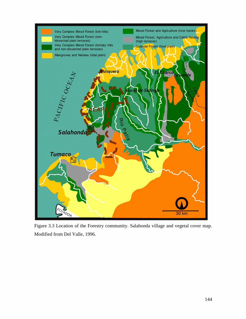
144
Figure 3.3 Location of the Forestry community. Salahonda village and vegetal cover map.
Modified from Del Valle, 1996.
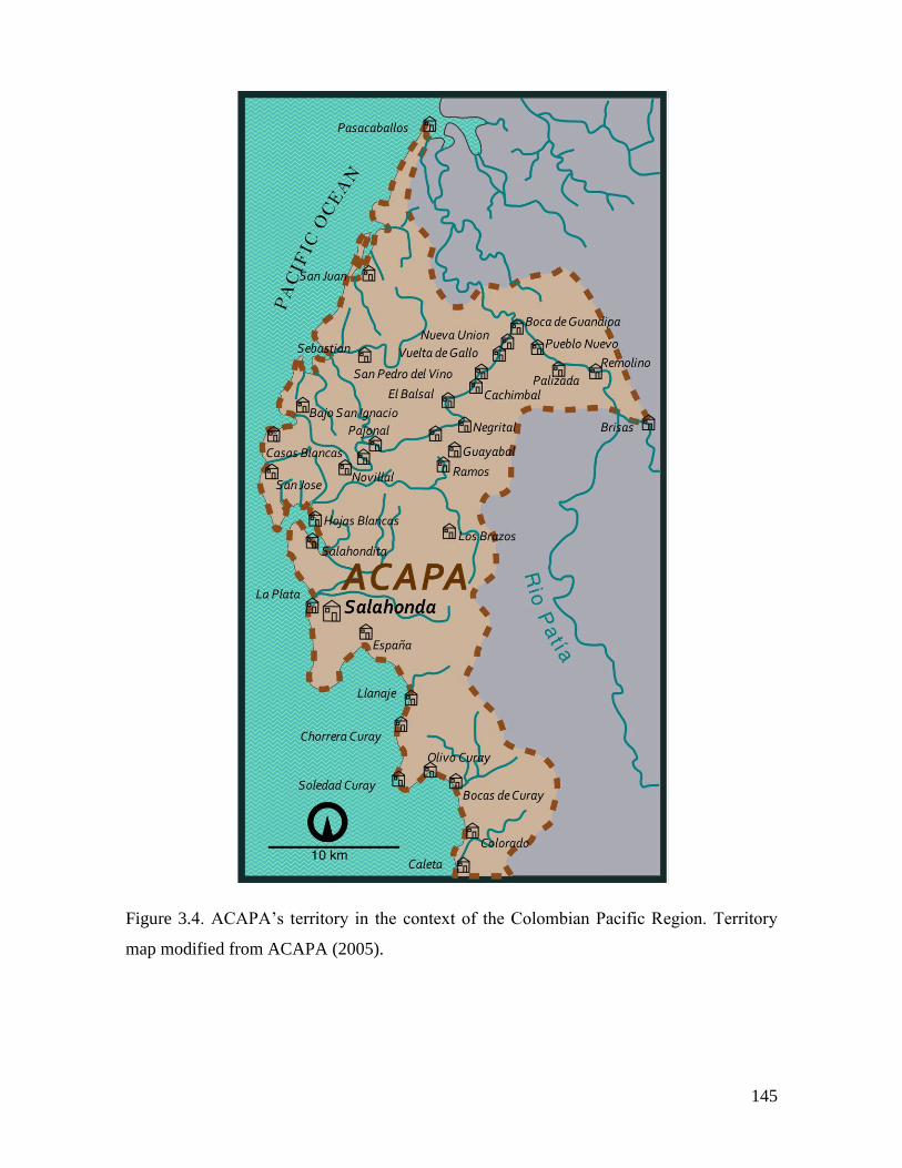
145
Figure 3.4. ACAPA’s territory in the context of the Colombian Pacific Region. Territory
map modified from ACAPA (2005).
146
Brief historical overview of population processes
Next I will give a brief overview on the population history of the region. I used information
produced by ACAPA (2005) and other authors that have investigated the Coquest and
Colonial periods.
First vestiges of human population in the South Pacific Lowlands date back from
7.000 B.C. Mangroves has been considered as an strategic ecosystem for pre- Hispanic
settlers. During IV and II centuries BC archeologists have recognized a cultural complex
called Tumaco – La Tolita present in the North Pacific Coast of Ecuador and the South
Colombian Pacific Coast. One of the characteristics of pre-Hispanic cultures in the region
was the intensive utilization of Mangrove and marine ecosystem resources, especially
mollusks. During Tumaco - La Tolita period, according archaeological studies (ACAPA,
2005), population density was high and it was necesary the knowledge, adaptation and
utilization of the different ecosystems.
Spaniards found, in XVI century, a several indigenous groups who made a strong
opposition to the Europeans. The main groups were Tumas, Iscuandés, Nulpes, Guapis,
Sindaguas and Barbacoas, their resistance was based on the sprawl settlement pattern, a low
social stratification (ACAPA, 2005), and the hard environmenmtal conditions to which the
invaders were not used. Finally, according Oviedo (1996), in 1536 the main indigenous
chiefs were assasinated and the Spaniards can rule the territory without major resistance.
According ACAPA (2005), between 1600 and 1650 Spaniards started their
occupation, exploitation and spatial distribution proceses in the region. The fundamental
economic activity was the gold mining, and the rest of produvctive activities developed
around it. From mining enclaves Europeans explored the upper and middle parts of the
rivers. Towards the middle of XVII century, indigenous labor force induced to the
Spaniards to the introduction of African population, as slaves, for mining activities. As a
consequence African people started to be numerically higher than the other groups, while
the remaining indigenous groups were displaced to the higher parts of the Colombian
Western Cordillera, towards the East.
The arrival of African slaves started the second aluvial gold mining exploitation in
the late 17th
century (Maya, 2004). Africans arrived from Cartagena that was the legal slave
trade port and from Panama, the illegal ones. The origins of African population was Sudan,
147
which people came from the Kingdoms of Ghana, Fanti and Ashanti. People from the rivers
of Guinea, Sierra Leona, Arará, Mina, Carabalí, Congo and Angola, but the majority of
Africans that came to the Colombian Pacific coast were from Guinea coast and Congo
(Flórez & Millán, 2007). Most of the slaves, in 1759, were from the Ashanti Confederation
(28,7%), from Ewe-Fon of Dahomey and Youruba of Benin (19%), from Bantu kingdoms
form Congo and Angola (16,3%), and from Mali kingdoms the 4,1% (Sánchez et al. 1993,
in (Flórez & Millán, 2007). According Flórez and Millan (2007), the prefered groups for
the mining work were from Congo and Carabali tribes because of their physical strenght.
The settlement pattern of Afro-Colombian population is explained by (Oslender,
2002). There were two forms, for slaves, for becoming free people in the Colombian
Pacific. They could escape, becoming cimarrones, or they could buy their freedom with
gold. The first, settled in the farthest parts of the rivers, and the latest, used to follow the
Spaniards gold mining troops in their movemenmts along the rivers and slowly they
abandoned the activity, settled down in the banks of the rivers and slowly changed their
productive activities to agriculture and river fisheries. Through this process, “the slavery
was entered in another phase…of black free territoriality construction” (Romero, 1993
cited in Oslender, 2002), which led to a particular space structuration, which Oslender calls
“the logic of the river”. However it was only since 1851, with the slavery abolition, that the
sprawl population process along the rivers was consolidated generating the “lineal village
in line on the river bank” (Aprile, 1993 cited in Oslender 2002). In addition to the
advantages regarding productive soils for agriculture and a risch fishery offer, the the rivers
became the roads of the Pacific (Oslender, 2002 ). This form of structuring the space
persists today and determines people daily life, social relations, society nature relations, and
forest use.
In the next section I will go through the history of the natural resources extractive
cycles and a small description of economic activities, focusing on the forest utilization.
148
4.2.4. Salahonda: Economic activities
Agriculture in the ACAPA’s territory is constituted by associated crops except for the rice
and occasionally plantain. In the farms there are several products such as cacao, sugar cane,
yucca, corn among other tropical crops. Artisanal fisheries are important in the territory, the
activity is practiced in the Patia River, small lakes and the sea, and a high variety of fishery
gear is used. People from ACAPA’s territory practice hunting taking advantage of the
tropical humid forests of the region. Main species captured are rabbits, fox, armadillos,
Tiger Cat or Tigrillo (Leopardus tigrinus pardinoides), some monkeys species and several
birds of the Cracidae family, among others. They use, as hunting gear, rifle and traps
(Ospina, 2008). The author remarks the fact that this activity has been decreasing due to
cultural and ecosystem changes. People use to collect diverse forest products for household
consumption, medicines, construction materials and tools manufacture. Mangrove
ecosystem is an important source of clams, which are collected mainly by women and
children, and represent an important economic activity for household consumption and
local trade. The mollusk species they collect is the Anadara tuberculosa, which is harvested
in the whole south Pacific coast, including Ecuador north coast. Livestock, as pigs and
poultry, is maintained in households for self consumption. In some areas people have
cleared the forest in order to maintain cattle of small scale (Ospina, 2008).
During the late 90s coca illegal use crops have started to occupied important areas
of the territory (Ospina, 2008). According the Colombian National Police information
service in the municipality of Salahonda there were 1.350 Ha of coca crops in the year 2002
(Martínez, 2006).
Forest exploitation is the most important economic activity of the region. The
Pacific has been international and national exporter of timber during some periods of the
20th
century. Next I synthesize this history for the region of Tumaco with emphasis on
ACAPA’s territory, based on the research of Leal and Restrepo (2003) and Ospina (2008).
Natural resource extractive cycles
The economic model that has dominated the Colombian Pacific Region during more than
three centuries is an extractive economic model (Leal and Restrepo 2003). According the
authors, an extractive economy implies that the resources are mainly created by nature
instead by the human work. The term economy implies also that the extractive processes
149
must be the axis of the region’s economy, such processes are the set of activities which
generate accumulation, and it means that subsistence extraction is out of the concept of
extractive economy. The region has served as a big pantry since Spanish conquest times in
a number of cycles that began with the gold extraction from 16th
century to the end of 19th
.
The next cycle consisted in the collection of Tagua (Phytelephas macrocarpa) seeds and
latex from rubber trees for commercialization in the United States and European markets,
this phase lasted until the middle of 20th
century. The second half of 20th
century has been
characterized by a wood extraction cycle (Leal and Restrepo 2003). As the same authors
state several wood extraction decades have modeled the physical and social landscape of
the region, and in order to understand the Colombian Pacific region it is necessary to take
into account the history of logging activity (Leal and Restrepo 2003).
The logging in the Colombian Pacific has three main extraction areas, from south to
north, the first is located in the influence area of Tumaco city, second, Buenaventura city
and the coast, and the third in the Atrato River basin (Leal and Restrepo 2003). The case
study (Salahonda village) is located in the Tumaco influence area which has had three
historical phases, according Leal and Restrepo (2003), which will be summarized next.
- First phase: Late XIX century – 1950.
The mechanized forest exploitation started towards the end of the 19th
century, until
the peak of timber exportations in the middle of 20th
century. This phase was characterized
by the existence of few sawmills in Tumaco and Salahona. The incipient industry satisfied
mainly local markets, and the wood was extracted from forests near to the villages.
Specialization of loggers was minimum, sawmills bought the wood to people who cut
timber as one activity more among several others for household subsistence. Between 1940
and 1943 the timber experts increased towards the United States in order to satisfy the
demand for the war airplanes in the Second World War. By this time there were two
sawmills installed in Salahonda (Leal & Restrepo, 2003).
- Second phase: 1950 – 1975.
Middle of 20th
century marks the timber extraction peak in the region characterized
by “alien capital intervention, technologic innovation in sawmills, extraction boundary
advance, the growing importance of the sector for the zone, and the consolidation of a
group of loggers and wage earners dependent of the industry” (Leal & Restrepo, 2003: 49

150
– my translation). This peak period in timber extraction industry has its causes in the 30s
and 40s decades. The development of synthetic substitutes for the Tagua (Phytelephas
macrocarpa) and the natural rubber production in the Asian South East, in these two
decades, led to the collapse of both extractive activities (Leal & Restrepo, 2003; West,
1957). During this period Salahonda was an important place for the collection of the timber
from the whole Patia River. In 1957 there were around 14 sawmills in the Pacific Zone of
the Nariño department, by 1965 there were 39, in 1969, the figure reached 55 sawmills.
Tumaco and Salahonda concentrated most of the sawmills of the department.
The history of the most important forestry company that operated in the zone gives
an idea of what happened in the zone during this period. The company started its work in
1954 with a mix of Colombian and foreingn capitals, and controlled all the exports to USA
and Canada. In 1963 was sold to a USA corporation, but in 1967 went banckrupt and
passed to another USA corporation control, and in 1969 it had a consesion of 72 thousand
HA in the banks of the Patia River. From 1971 to 1973 it was composed again for mixed
capital, Colombian and USA, and it export tens of thousands tons of timber. Finally in
1976, the company stopped to pay wages generating an important laboral and social
conflict (Leal & Restrepo, 2003). According these authors the causes of the final failure,
not only of this company, but of the peak extraction cycle finish, were three: a) the
depletion of wood stocks in the Patía River, and b) the building of Naranjo Channel, which
change the timber exploitation towards the north, the zone of the Sanquianga River. Until
the middle of 70s Tumaco and Salahonda region produced the 65% of the timber in the
Nariño Pacific Coast (Leal & Restrepo, 2003).
- Third phase: 1975 – present time.
The third phase of timber extraction industry is characterized by the existence of
few sawmills, which sell their products to companies in the interior of the country, and a
small percentage of the production satisfies the local demand. In contrast with previous
phases, in this period, there are corteros (chain-saw men) that go directly to the forest and
sell timber to the sawmills, and the main tree species exploited is the Sajo (Campnosperma
panamensis) (Leal & Restrepo, 2003).
The early 90s mark a milestone in the institutional framework for the relation
between the society and ecosystems in the whole Colombian Pacific Region inhabited by
Afro – Colombian population. According the 1991 new Colombian constitution, the
151
country is a multi cultural and pluri ethnic state. The constitution also sets a framework for
a National Environmental System tightly related with social dimensions. One of the
consequences is the Law 70 of 1993, or the black community’s law, that fundamentally
gives autonomy to Afro-Colombian population on the governance of their territories. In this
scenario, ACAPA has the responsibility and the right to decide how to negotiate and to plan
the forest management of its territory. However, the governance of the Council is
constrained by the different armed groups that enter into the territory defending the coca
crops (Ospina, 2008), and sometimes the interests of national and international capitals
interested in the timber and the new African palm plantations projects. In this way, the first
formal local ethnic governance system with possibilities to design institutions for the forest
management is limited by armed actors interested in the territory (Ospina, 2008).
4.2.5. Salahonda: Territory, space conceptions, and social organization
Black social movements in Colombia, before the Constitution of 1991, were focus on social
inclusion and anti discrimination vindications influenced by USA black movements for
social rights of the 60, 70 and 80s (Rivas, 2001). After 1991 “Colombian black community
is defined by its cultural singularity, as a result, on one side, of a common origin and
ancestral roots in the African continent, and on the other side, by shared traditional
practices, configured in the historic experience of an isolation and territorial construction
strategy” (Restrepo, 1997: 300 in Rivas, 2001). This new dynamic, in the Colombian
Pacific region is fed by the Law 70 for black communities, the collective land entitlement,
cultural traditions, and the biodiversity and sustainable development discourse (Escobar,
1997). This new period leads to a particular definition and inclusion of the notion of
territory in institutional crafting and natural resources management strongly linked to
cultural characteristics.
Before to discuss the notion of territory in the region, it is convenient to, briefly,
explain the type of space upon which the territory has been built. As I mentioned above, the
river has been the axis of the life in the Pacific, and it has been the main communication
way, therefore it has consolidated as the most important social space, around which all
economic, cultural and social interactions have been structured (Oslender,2002). Oslender
has coined the term “aquatic space” regarding to how the “specific ways in which
“aquatic” elements, such as the high levels of rain, tide impacts, the labyrinthine networks
of mangroves and rivers, and the frequent floods, among others, have influenced the daily
152
life forms”. Of course the logging is not an exception to this fact, the high changes in water
level due to the tides, not only in the marine coast line, but through the whole extension of
the rivers, determines the timing and the form of take out from the forest and transport the
timber. Hoffman (2002) calls the “fluvial bank dispositive” to the specificity of the region
that was taken into account by the mentioned Law 70, which recognizes singular agrarian
and ethnic conditions that have produced a very particular socio-espatial configuration.
According Oslender (2002), “In the local geographic imaginary, different parts of a river
are mutually interconnected, and they have to be considered as integral parts of the same
socio-cultural and economic system”. The conexion in any particular basin is given, not
only by the fluvial trade flow, but, by the land distribution (Oslender, 2002).
Scholars, and particularly anthropologists refer to the Colombian Pacific region as a
“different world, with a very particular cognitive and structural model, and a univers of
different meanings” (Escobar, 2000: 151- my translation). This vision has to do with the
political discurse that has been built, by local social organizations, since the 90s, around the
concept of territory, biodiversity and culture. According the anthropoligist of the
development, Arturo Escobar, social movements in the Pacífico have introduced several
important conceptual innovations. The first is the definition of biodiversity which is equal
to territory plus culture, in the second place it is the territory-region of ethnic groups,
which represents an ecologic and cultural unit produced trhough the community daily
practices. “The territory-region is a management category that points out the construction
of of alternative life and society models … it is an attempt to explain the biological
diversity from the ecocultural logic of the Pacific. The territory is the space used to satisfy
community needs…The territory represents the community life project.” (Escobar, 2000:
137- my translation).
This notion of territory is an attempt to remark the relation between space, culture
and nature, where the territory is a conceptual unit and a political project. The concept has
one of their more relevant axes around the relation between land collective entitlement and
settlement patterns (Escobar, 2000).
153
4.2.6. Salahonda: Problems and Potential Shocks
Since early 90s formal institutions, at national level, have produced important changes at
regional and local scale in the Pacific Coast. The political discourse developed of Afro-
Colombian activists has focused on the relation between society and nature, and specially
the notion of territory has served to vindicate their autonomy in natural resource
management.
Environmental policy focus has changed from a traditionl conservationist
perspective to an integral vision of ecosystems and society. Several authors have affirmed
that the Law 70 have been possible thanks to two kind of situations: internal logics of the
country such as violence regional issues, and international pressure such as Human Rights
violations, ethnic minorities abandon, and environmental defense (Agudelo, 1999;
Hoffmann, 1998, in Rivas, 2001). But according to Rivas (2001) the fundamental interest
of Colombian government is the biodiversity protection, and the law is not really an
institutional framework for Afro Colombians, but for the country insertion in the
international arena of biodiversity conservation15. The way black communities of the
Pacific are integrated to environmental conservation process, consists in the compulsory
character of conserving the environment that comes with the collective land titles (Rivas,
2001).
ACAPA was created in 1992 as a traditional peasant organization and it was
transformed in a Comunitarian Council in 1997, when it applied to the colective territory
entitlement. This fact has deep implications in the real relation between people and natural
resources, and particularly in forest management, because people traditionally managed
their lands with private property rights, and under the individual production unit peasant
logic (Rivas, 2001). The Law 70 is based on the idea that local communities traditionally
have carried out their productive practices in tune with biodiversity conservation.
According Rivas (2001), the productive history of the Pacific have been characterized by
two contradictory production forms: the intensive extraction of natural resources by
corporations of national and international capitals, the timber extraction from forest by
15 The “Biogeographic Choco” (“Chocó Biogeográfico”), which includes the entire Colombian Pacific Coast,
has been recognized as the region with the highest biodiversity per unit of the world. This is, 400 vegetal
species and 800 invertebrates species, which is higher than the Amazonian figures (Rivas, 2001).
154
locals as a unique livelihood, and the permanence of “sustainable” practices based on the
combination of several crops in their individual parcels.
In this scenario, there are four points that constitute the main problems and
perturbations that is facing the community of Salahonda that influence institutional
arrangements:
1) Illegal crops (coca) advancement, lead by paramilitars and the subsequent
conflict, and control of the territory. It implies a modification of the formal and
informal institutionality that could affect the forest management and ACAPA’s
gobernance of the territory.
2) Incentivated by the national guvernment, the implementation of agroindustries
and monoculture (African Palm plantation projects) by national and
international capitals.
3) The territorial-ethnic-environmental discurse of local activists does not reflect
the daily life practices of the population, in terms of the pretended ancestral
communitary use of the land. This fact leads to conflicts among leaders of
ACAPA difficulting an effective process of institutional arrangements crafting.
4) Until the late 20th
century the mental model about nature that drove official
environmental policy and the society’s perception towards the region was of a
“Balanced Nature”, dominated by negative feedback processes (Holling et al.,
2002).
155
4.3 Aqueduct community of Lenguazaque village
4.3.1. The Central Colombian Andean Region
Colombian territory has been divided in five Natural Regions according altitude, geology,
and soils. The Natural Andean Region includes the Western, Central and Eastern
Cordilleras and the intra Andean valleys of the Rivers Cauca and Magdalena. Climate and
vegetation are highly variable and the height is the characteristic that determines the
bioclimatic zones, which include 20 sub-regions (IGAC 2002). One of these sub-regions is
located in the central area of the Western Cordillera which is called the Cundiboyacense
high plain.
The dominant character of the region are the mountains with steep slopes which
surround the extense plains. Altitudes are from 2.000 to 3.500 masl, which give the
possibility of a high variety of climatic zones. This fact allowed pre hispanic inhabitants of
the zone, the Muisca ethnic group, to develop a wide range of agriculture activities and
favouring high population densities. Though water is essential for Andean population
processes, it plays a secondary role compared to mountains, in the organization of dayly life
and economic activities. In the pre Hispanic society settlements stablishment searched
convenient location regarding water bodies, but they were abundant during the year,
instead, the variation of slopes were the main driver for land use allocation decisions
(Herrera 2002). Another consequence of this physiographical configuration is the
devlopment of micro climatic conditions, which give a high variability conditions on daily
basis. It means that, in periods of global dry conditions, locally, could be rainy and sunny
days in the course of one week for example, and vice versa with high precipitation global
periods.
The most recent official Atlas of Colombia (IGAC, 2002) classifies the population
according cultural criteria. About Andean population in general it states that it is the wider
and complex culture of the country’s center, and it is classified as a “cultural region of
Hispanic origin”. Its main origin is castellano16 because the Spaniards settlers in the region
16 In English, Castilian, refers not only to a specific language (Spanish), declared in the Spanish constitution
as the official language, but to the central Spanish region, origin of the modern country, and the main
provenance of the Spanish conquerors.
156
were, mainly, from this Iberic province. The racial mixing with the aboriginal Muiscas was
intense, compared with afro descendents’ influence. Andean region has been the most
densely populated by pre and post Hispanic periods (IGAC, 2002). One of the cultural
types, in this region, is the so call Cundiboyacense, the one that irrigation case study of this
research belongs to. The Atlas characterizes this cultural type as “of high racially mixed
type between Spaniards and aboriginal, respectively from Andalusia and Chibcha
indigenous family. A natural from this region is traditionalist, proud, hard worker,
individualist and reserved. … Religiosity is deeply rooted among its population, and
supports the social structure” (IGAC, 2002: –my translation).
The irrigation case study is a SES located in the Northest part of the
Cundiboyacense high plain, in the upper part of the so called Fuquene or the Ubate –
Chiquinquira Basin. Although I have organized the text with these titles, dynamics of the
different dimensions, geology, landscape, ecology, socio-cultural and economics, are
understood as interdependent. The relation of people with the ecosystem and its goods and
services in part is product of a partiular culture and economic rationality. In this region,
water management is maybe the dimension that best reflects these particular rationality,
having into account that, as it will be discussed below, water, was until the beginning of
20th
century, an abundant CPR withouth the problems that we find today in the zone.
Cooperation dilemmas, social norms functioning, collective action problems, and
institutional dynamics are specially challenging in a watershed context plenty of
externalities at different scales with severe individual, collective and ecosystemic
consequences. We will see how the combination of a specific cultural setting, social
control, and institutional dynamics produces poor conditions for CPR gobernance.
4.3.2. Lenguazaque: The biophysical environment
The irrigation case study is located in the Eastern Cordillera of Colombia, which includes
several inter-Andean basins. In its central part the diameter of the Cordillera increases and
includes the high flatlands of the intra-Andean high plains. From south to north there are
the Basin of Bogotá and the Basin of Ubaté-Chichinquirá. Lenguazaque village, were the
irrigation community belongs, is located in the northern basin, which is still covered by an
important body of water called Lake Fúquene. The modern geomorphology of the central
157
area of the Eastern Cordillera is characterized by the presence of intra-montane valleys
surrounded by folded Cretaceous and Paleogene rocks. These valleys collected lacustrine
sediments during the Pleistocene (Sarmiento et al. 2008). Lake Fuquene is one of these
remanents of big Pleistocenic lakes and it is the center of Fuquene Basin or Ubaté-
Chichinquirá Basin.
The irrigation case study site is localized 100 km north from Bogotá. The area is
part of the Fuquene Basin, which has an area of 1.752 km2. Human population of the
watershed is 229.000 (DANE, 1993). The zone is the second largest highland plateau after
the Sabana de Bogota in the Eastern highlands, ranging from 2.500 to 3.300 masl. The
region is about two hours’ drive by car from Bogotá. The village of the case study,
Lenguazaque, is located in the eastern border of this watershed.
Lenguazaque’s historical, geographical, environmental, economic and socio cultural
context cannot be separated from the Fuquene watershed region. Problems facing by the
irrigation community studied in this research are representative from the region. In terms of
ecosystem importance, the wetland system of the Cundinamarca and Boyaca high plateau,
to which Fuquene watershed belongs and it is one of the most relevant, is the Andean
center of biological diversity and endemism of fresh water biota more important of the
North of South America. The system belongs to the biodiversity hotspot of the tropical
Andes defined by Conservation International (CI) as world conservation priority area
(Humedales).
The problems of the region related with ecosystem services and function, land use
conflicts, socio-cultural and economic practices affect and are affected by one key resource:
water. Fuquene Lake has been, since pre Hispanic until current times, a central
geographical accident of religious, socio-cultural and economic importance for the different
population groups that have occupied the region. According ethno historical and geological
sources, the area of the lake in pre Hispanic times was about 1.000 km2 (Maya et al. 2004).
Between 1940 and 1955 the desiccation rate was of 17,65 Ha/year, and between 1993 and
1999 was of 39,93 Ha/year, according these data, in 2034 the lake will disappear
completely (JICA, 2000). 1.204 Ha out of the 3.000 Ha of current lake area are invaded by
massive bodies of aquatic plants (Elodea Canadensis, Limnobium laevigatum and Scirpus
californicus) due to intense eutrophication processes generated by nitrogen and
158
phosphorous from productive activities and non treated sewage from human settlements
(Fundación Humedales).
The landscape structure of the region that one observes today, which height varies
from 2.400 to 3.750 masl, is formed by sedimentary rocks from Cretaceous, Tertiary and
Cenozoic geological periods. The geology of the area has been studied by Hubach (1953),
Etayo (1968), McLaughlin & Arce (1975), Ulloa and Rodriguez (1991) and Sarmiento et al.
(2008). Part of the stratified rocks that forms the relief of the zone were deposited in
shallow sea bottoms and marine coasts during the Cretaceous period. Another important
rock bodies were deposited in wide estuarine and swampy environments during Tertiary
period, these formations contain the coal deposits that are very important for the present
economic activities towards the East of the zone. Cenozoic deposits from fresh water lakes
post Andean raising are filling the plain intermountain valleys. All these deposits, which at
the end of the Mesozoic (65MA b.p.), were at the sea level, began to rise during the
Paleocene, when the uplift of the Andes began in the Paleocene (65 – 55 MA b.p.) as a
consequence of tectonic plates crash between Pacific and South American plates. The
Andean uplift finished in the Plio-Pleistocene (5 -4 MA b.p.) reaching nowadays altitudes.
The region was finally shaped by a sequence of several glacial and interglacial periods
during the last part of the Quaternary period (44.000 – 21.000 b.p.). Since the Plio-
Pleistocene a series of global and local climatic changes drove the dynamics of the present
main ecosystems of the region: lakes, high Andean forests and paramo17.
Hydrography and the sub-dendritic drainage system (CAR 2006) of the basin has
been mainly controlled by “the characteristics of the bedrock units and tectonics; erosion
by ice masses formed glacial cirques, hanging valleys, and deep U-shaped and V-shaped
valleys. Lake Fúquene is fed by the Ubaté River which has a natural drainage in northern
17The paramo is an Andean ecosystem which starts at 3200 to 3300 masl covered by tropical alpine
grasslands. The paramo is found between 3200 and 4500 masl. The importance of this ecosystem is in its
water producing, regulating and stocking function. It is characterized by extreme environmental conditions,
low atmospheric pressure, low air density, low mean temperatures, high air and soil temperature with direct
solar radiation and low temperatures when there is no sun radiation. The vegetation is of low height exposed
to strong winds. Annual mean temperatures varies from 15 ºC to -5 °C. The main vegetal species is the
“frailejon” (Espeletia spp.), and extended grasslands with wetlands occurrence (Guhl, 1982). Soils are highly
productive and suitable for potato agriculture and cattle rising, uses given by peasants today. The ecosystem
has a high degree of endemism of vegetal and animal species, which makes the paramos a strategic ecosystem
regarding evolution and conservation. The paramo has been considered as a sacred place by local indigenous
communities.
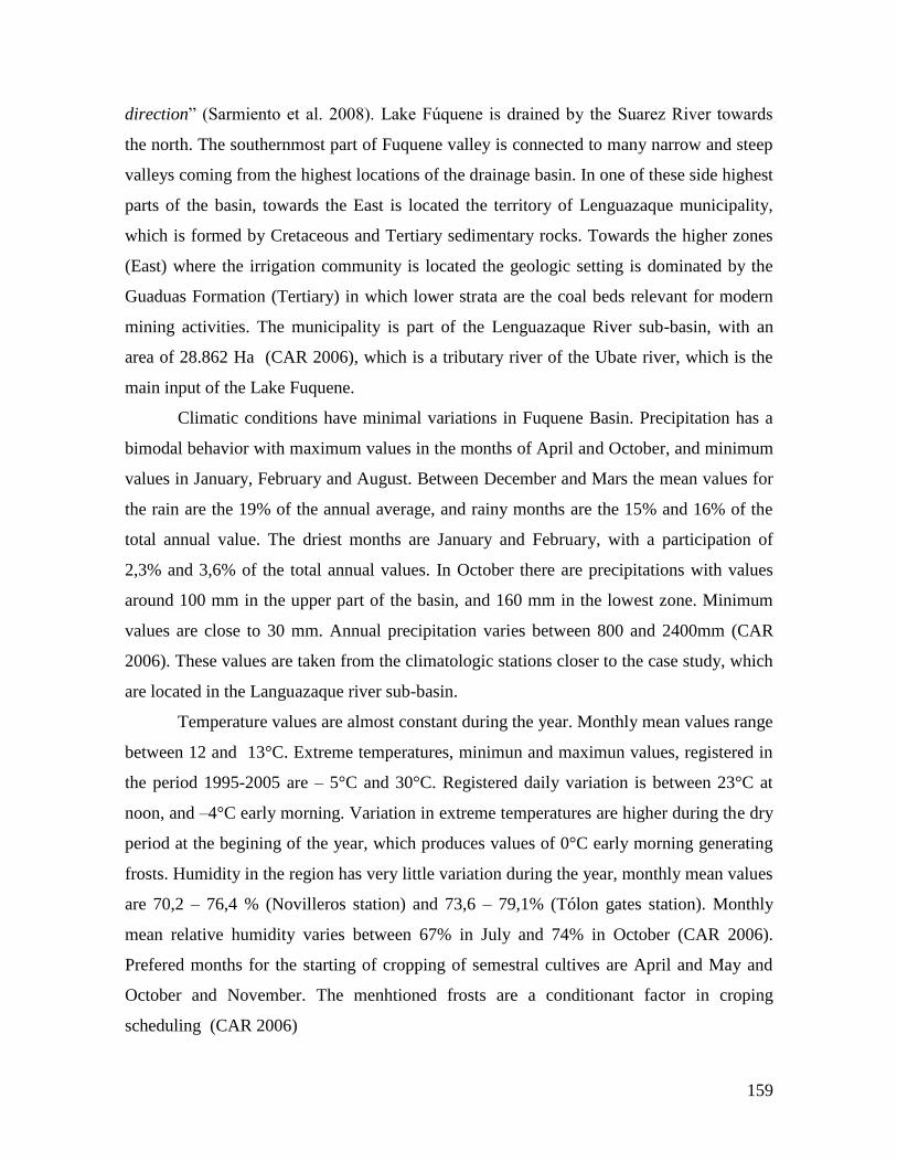
159
direction” (Sarmiento et al. 2008). Lake Fúquene is drained by the Suarez River towards
the north. The southernmost part of Fuquene valley is connected to many narrow and steep
valleys coming from the highest locations of the drainage basin. In one of these side highest
parts of the basin, towards the East is located the territory of Lenguazaque municipality,
which is formed by Cretaceous and Tertiary sedimentary rocks. Towards the higher zones
(East) where the irrigation community is located the geologic setting is dominated by the
Guaduas Formation (Tertiary) in which lower strata are the coal beds relevant for modern
mining activities. The municipality is part of the Lenguazaque River sub-basin, with an
area of 28.862 Ha (CAR 2006), which is a tributary river of the Ubate river, which is the
main input of the Lake Fuquene.
Climatic conditions have minimal variations in Fuquene Basin. Precipitation has a
bimodal behavior with maximum values in the months of April and October, and minimum
values in January, February and August. Between December and Mars the mean values for
the rain are the 19% of the annual average, and rainy months are the 15% and 16% of the
total annual value. The driest months are January and February, with a participation of
2,3% and 3,6% of the total annual values. In October there are precipitations with values
around 100 mm in the upper part of the basin, and 160 mm in the lowest zone. Minimum
values are close to 30 mm. Annual precipitation varies between 800 and 2400mm (CAR
2006). These values are taken from the climatologic stations closer to the case study, which
are located in the Languazaque river sub-basin.
Temperature values are almost constant during the year. Monthly mean values range
between 12 and 13°C. Extreme temperatures, minimun and maximun values, registered in
the period 1995-2005 are – 5°C and 30°C. Registered daily variation is between 23°C at
noon, and –4°C early morning. Variation in extreme temperatures are higher during the dry
period at the begining of the year, which produces values of 0°C early morning generating
frosts. Humidity in the region has very little variation during the year, monthly mean values
are 70,2 – 76,4 % (Novilleros station) and 73,6 – 79,1% (Tólon gates station). Monthly
mean relative humidity varies between 67% in July and 74% in October (CAR 2006).
Prefered months for the starting of cropping of semestral cultives are April and May and
October and November. The menhtioned frosts are a conditionant factor in croping
scheduling (CAR 2006)
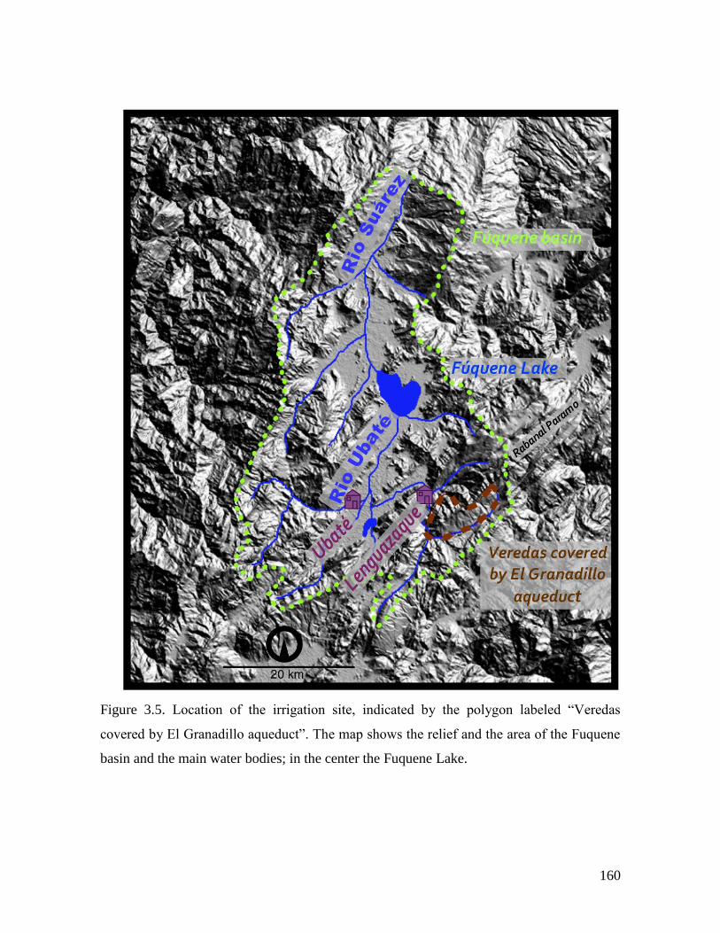
160
Figure 3.5. Location of the irrigation site, indicated by the polygon labeled “Veredas
covered by El Granadillo aqueduct”. The map shows the relief and the area of the Fuquene
basin and the main water bodies; in the center the Fuquene Lake.
161
Figure 3.5. Location of the area covered by the Granadillo aqueduct in the Lenguazaque
Municipality.
162
4.3.2. Lenguazaque: The Social System
The currently population of the Fuquene region is the product of a racial mix between the
ancient ethnic indigenous group, the Muiscas, whose language belonged to the Chibcha
linguistic family, and Spaniards ethno-linguistic group, mainly belonging to Castilian
subgroup. This mixed produced the cultural type called Cundiboyacense, whose individuals
are adapted physiologically, and in terms of their relation with the ecosystems, to the
Andean environmental conditions.
The vereda Tibita Centro belongs to the municipality of Lenguazaque where
Gonzalo Jimenez de Quesada, Spanish conqueror of the Central Colombian Andeans,
arrived in 1539 and annexed the region to the invaded territories with the name of Sevilla.
In 1780 it was categorized as Municipality and was given its modern name, Lenguazaque,
which was the original Muisca name that means “the end of the Zaque’s dominion”18
(Dirección Departamental de Estadística., 1954). Lenguazaque has a total area of 17.327
ha, with 32 ha of urban area and 15.635ha of rural area, which is divided in 21 veredas
(Rubio, 2001). Inhabitants of the municipality belong to the cultural group called
campesino19 cundiboyacence. Lenguazaque has a total population of 9.769 distributed in
2.094 in the urban area and 7.675 for the rural zone (DANE 2005). The community where
the case study was carried out is located in the vereda20 Tibita Centro which population is
249 (DANE 2005).
In the next section I give a short journey of the history of the Fuquene region, in
terms of human population, relation with the environment, settlement patterns, social
change and political organization. Given the overwhelming historic literature focused on
the Colonial and subsequent periods for the region, and the relatively scarce studies on pre
Hispanic history I tried to balance the information in order to offer the most relevant
elements for the purpose of this research. Sources of information available for the history of
Central Andean regions range, from archaeological findings, ethno historical sources like
18 At Spaniards arrival, the Muisca Confederation was divided between two Kings: The Zipa and the Zaque.
The Zipa controlled the southern part, towards Bogotá, his name was Tisquesusa, and the Zaque that
controlled the Northern region, whose name was Nemequene, and the center of his dominion was Tunja. 19
The closest translation in English for “campesino” is “peasant”. 20
The “vereda” is a rural territorial division of administrative character of Colombian municipalities.
“Veredas” include human settlements that can be sprawl or concentrated in some areas.
163
chronicles in the first centuries of Spanish invasion, descriptions of the XIX century
European naturalists and travelers and modern historiography and geographic studies.
History of population processes in the zone
The first evidences of human population in the zone dates back from the year 800 BC
(Langebaek, 1995), but the emergence of the Muisca society occurs around year 1000 AD
encompassed of climatic changes that caused the decreasing of the Cundiboyacense high
plain’s big water surfaces, allowing territorial expansion (Rubio, 2001). In Langebaek’s
study “Regional Archaeology in the Muisca Territory”, carried out specifically for the
Fuquene Basin region, he proposes four periods to understand the evolution of population
settlement in the zone. Preceramic and Herrera Periods (800 BC. to 800 AD.), Early
Muisca (AD 800 – to 1200), Late Muisca (AD 1200 to 1600), and the Colonial Period (AD
1600 to 1950).
Preceramic and Herrera Periods
Langebaek reports only one archaeological place with possible evidences of
preceramic settlements, with abundant pressence of lithic material. The author concludes
that, if the site was inhabited in a previous time of the ceramic introduction, this occupation
was higly limited. The first evidences of ceramic introduction with liable radiocarbon
dating have been allocated to the period called The Herrera Period21. In this period
population was small and it was far from the environmental carrying capacity. There is a
poor correlation between fertile land and Herrera settlements. Regarding social
organization, there are no important evidences for political centralization. There is no doubt
that the demographic density is low in this period with a range that could variate from 3 to
10.8 persons per km2. Interestingly enough, according Langebaek, is that these figures are
inferior to a density of 64 persons per km2
., which is considered as the minimun for many
societies to practice intensive agriculture (Netting, 1990 cited in Langebaek, 1995). The
author concludes that Herrera population was small, and also a society with egalitarian
21 Broadbent (1970 cited in Langebaek, 1995) carried out the first archaeological research, not systematic, in
the Lake Herrera in the South of Bogotá, where he reported ceramic material different to the classical Muisca
type. Cardale (1974, 1981 cited in Langebaek, 1995) established formally the Herrera period, geographically
and temporally. Spatially, sites with these characteristics have been found in several locations in all the
Cundiboyacense high plains (Langebaek, 1995).
164
levels of socio-politic integration. Herrera settlers probably were in the capacity to self
sustain with corn produced in their settlements’ surrounding lands. Finnaly, regarding
social interaction with another societies, there is absence of evidences of practices of
product exchange for this zone (Langebaek, 1995).
The Early Muisca Period
Langebaeck observes dramatic changes between the Herrera Period and the next Early
Muisca Period (AD 800 – to 1200) in terms of pottery, settlement patterns and mortuory
practices. Some authors associate these differences with invations from other regions. The
continuity of Herrera settlements may suggest some kind of ethnic continuity. The
demographic density in this period was in a range from 6 to 21.8 inhabitants per km2. In
contrast with Herrera settlemnts, which are located without any defensive logic, Early
Muisca sites show a location not always closer to the more suitable agricultural places, but
in former islands with abrubt elevations from the shore. In this period there is no evidence
of interregional trade. There are radiocarbon dates that suggest that mummification and
goldsmithing were introduced in this epoch. The Early Muisca, in syntheis is characterizd
by an increase in social complexity and population, warfare was an important factor in
orther to decide settlements location, and still it is evident a settlements’ descentralization.
Archaeological evidence, suggests that the Caciques22 took social distance from the
common population forming a political elite. Warfare, trade, and feasts, were important
elements for the social control (Langebaek, 1995).
The Late Muisca Period
The Late Muisca Period (AD 1200 to 1600) is characterized by several factors: a population
increase of great proportions, strong evidences of interregional trade, the fact that fertile
land acces was an important factor for settlement establisment, and political centralization.
Estimated figures for population density in this period range from 19 to 81 persons per km2.
According Langebaeck, in this period there are evidences that favors the hypothesis that
demographic density levels were over the carrying capacity of the ecosystems. Population
22 Political chiefs of the chiefdoms.
165
incresase could have been between 176 and 318%, and most of the population may have
been localized in the plain lands on the valley of the Lake Fuquene. Politically, the Muiscas
were organized in chiefdoms that controlled a number of small villages in the region.
During the XVI century those chiefdoms were territorial units, which domains usually
coincided with the modern municipalities (Broadbent, 1964 cited in Langebaek, 1995).
Capitanías were territorial and kinship entities that correspond to the current veredas. From
etno historic sources it is known that the main settlement of the chiefdom of Nemoga was
located in a mountainous zone near to Lenguazaque River. In the XVI century indigenous
population produced abundant agricultural land products and practiced intensive
agriculture. Spaniard’s crhonicles suggest that the Muiscas were in constant internal and
external warfare. All Late Muisca Period’s settlemts were below 2.900 m. (Langebaek,
1995). The same author calculated for this area a carrying capacity between 2.220 and
2.535 persons.
Palinological record shows that human ocupation of paramos started around 1200
AD (van der Hammen, 1968). The Muiscas combined different survival strategies such as
agriculture, hunting, fishery and collection of wild products. Their productive activities
were based on the microvertical exploitation, depending on the climate, of agricultural
products like corn, potato, , sweet potato, and other Andean tubers23 (Van der Hammen,
1992). With the Sapaniard’s invasion, intensive creals crops were introduced and the
agriculture frontier advanced due to food demand of the increasing population. The
hillsides started to be cultivated, and Andean forests began to be cut, ascending in altitude
approaching to paramo zones. Deforestation processes initiated due to the massive
utilization of timber by the Spaniards (Hofstede, 2002). Soil degradation processes in the
Cundiboyacense high plains was already happening before Spaniards’ arrival, according to
Langebaek study, mentioned above, there are evideneces, at least for the Fuquene region,
that carrying capacity was overshooted at the beginning of the Late Muisca period. In the
XVI, Spaniards introduced exotic fauna absolutly new for the Andes, such as cows, sheeps,
goats, pigs, chikens, donkeys among others. In terms of vegetation, they introduced species
23 Ibias (Oxalis tuberosa), Chuguas (Ullucus tuberosus) and Arracacha (Arracacia xanthorriza)
166
to be cultiivated in the high Andean mountains, specially wheat, and barley, carrots, lentils,
onion and garlic among others (Luteyn & Buck, 1999).
The Colonial Period
Settlement patterns were one of the first aspects of change in two forms. The first was the
dsiplacement of Muisca populations from their original settlemnts to new villages with the
squared structure according the Spanish way. And the second was the Spanish invasion of
productive lands and displcements of indigenous towards the worst lands, meaning the
hiilsides of the basin. The first type of organization was done by the creation of two types
of settlements: “pueblos de mison” and “pueblos de indios”24. The the first type was a
temporal religious kind of village, “which was considered as a transitional phase of
adecuation to the colonial order” (Herrera, 2002:53 - my translation). The “pueblos de
indios” were the final place where Spaniards located native populations, which “spatial
ordering … played a fundamental role in the process by means of which the population
interiorized the hierarquical order of the colonial society” (Herrera, 2002:161 - my
translation).
This period was marked by an important decreasing in Muisca’s population. This
decreasing was fundamentaly driven by the illness brought by Spaniards. By the end of
XVII Fuquene region had almost exhausted the native population (Moreno y Escandón,
1985, cited in Langebaek, 1995). Total human population increases considerably due, first
to the growing of Spanish and mestizo25 population, and second, although the decay of
native population was dramatic during the first centuries of the invasion, lately total
population, including indigenous, increased considerably. Langebaeck estimates the native
population size for the beginning of this period in a range between 2.340 and 7.334 for the
region. In spite of the population growth during this period, the author shows how the
environmental degradation that started before the Colonial period, but with Spaniars
invasion was incremented, is the result of land distribution patterns rather than a big
population.
24 The literal translation is Mision village and Indigenous village.
25 Mestizo refers to the mixing between Europeans and indigenous people.
167
Regarding social complexity, the study concludes that only since the early Muisca
period it is possible to talk about tendencies towards social complexity. The Late Muisca
Period portraits important evidences of social change and the end of egalitarian societies,
which is consolidated during the Colonial Period.
The last 500 years are fundamental to understand the modern state of the socio
ecological system in the Fuquene region, and of course the current relation between people
and ecosystems, and problems that face the community of Lenguazaque highest zones
including our case study in the vereda Tibita Centro and its irrigation system. In the next
paragraphs I will synthetize the most relevant aspects of since the Colonial period to
modern times.
The history of the region in the first half of the XX century “is the continuity of a
long term adaptation proccesses of its Amerindians inhabitants facing the presence of
Sapanish colonizers, and later, as a mestizo campesino community26 facing the milk
productive “haciendas” controlled mainly by European descendents and some mestizos
economically succesful”. (Flórez, 2005: 59 – my translation). The most important
institution used as a strategy to control the indigenous population and exploit the natural
resources during the Colonia was the encomienda27. This institution evolved, after
Independence in 1810, towards the hacienda28. During the Colonial period, the
encomenderos, in spite of the prohibition by the Spanish Crown of entitling the encomienda
lands to the Sapaniard in charge, they managed to create property titles and leave these
lands to their descendants. In the Fuquene region the hacienda structure was established in
the plain zones, as I already mentioned, the Spaniards dispalced indigenous to the sidehills
and upper parts of the watershed. This displaced population adapted to this dry
environment, and became a campesino society of mestizo and indigenous origin, that was
subordinated to the owners of the haciendas in the fisrts half of XX century trough political
and specifically electoral means (Flórez, 2005).
Maybe the most important ecological change produced by the introduction of exotic
fauna, in the 16th
century by the Spaniards, was the cattle. By the 19th
century, the ecology
26 mestizo peasant community
27 Encomienda definition in page 24.
28 Hacienda is the Spanish word for a big ranch where one or several productive activities were carried out,
from plantations, extensive cattle rising, mining or even factories.
168
of the plain zones of the basin were grass lands for milk cattle raisnig purposes. Hence, the
milk production cattle raising vocation of the economic activities in the valley were
consolidated in this century. By this time, while the hacendados29 made strong efforts to
control the waters of lakes and rivers due to the frequent floodings that harmed the grass
lands and cattle, campesinos from the hillsides and mountains struggled for survival due to
the intense dry seasons and erosions processes. Since the beginning of 20th
century, native
vegetation were already scarce on the hillsides. Guvernemental efforts were oriented to the
dissecation of the Fuquene Lake until the first half of the 20th
century, in order to aquire
new productive lands. The small campesino units of hillsides were characterized by
agriculture production and sheep rising, wich gave place to the wool handicraft production
that, currently, is one of the attrractivenes of the region, besides milk products. Since the
beginning of the 20th
century the growing and permanent food demand from Bogotá
boosted the agricultural production, and allowed the consolidatrion of a regular market of
agricultural products, especially potato from the higher zones of the mountains. About the
5% of the potato cultivated area could be irrigated, the rest was, and still today is, strongly
dependent on the rain. Potato agriculture contributed to the serious erosion processes and
later to the water pollution of creeks and rivers trough the agroquemichal inputs. By the
50s of the XX century coal miners arrived to the zone in a wave of poor and landless
migrants mainly from Northest Andean zones, which were isolated from the campesino
world of the region, and seen as “foreigners” (Flórez, 2005).
The result of the socio economic processes during the las 500 years is the folloging
configuration of the zone: On one hand, a population of campesino mestizo of indigineous
orgin without an ethnic community character, in the higher parts of the basin, and on the
other hand a large state property on the plain lands of the valley. This history produced a
campesino with an individualistic rationality with small properties and productive units30,
and an indigenous past of communitarian character regarding land property and production
(Flórez, 2005). Population increase in these parts of the basin has produced the
fragmentation of properties in order to distribute land among descendants. This process is
still working in the study zone.
29 Hacendado is the Spanish word for the owners of the haciendas.
30 The appropriated word in Spanish is minifundio.
169
From 1948 to 1963 Colombian history was characterized by a period called “The
Violence” because of the conflict between political parties. The Violence affected specialy
the rural world, but the zone of Fuquene Basin was atipically almost untouched by the
conflict at least in terms of armed actions. Flórez (2005) documents this period in his book
“Una isla en un mar de sangre”31 where he explains the causes of this situation as a
consequence of the relation of the Muiscas with Spaniards, and later, the owners of
haciendas and small campesinos, based on strong links with the ecosystem dynamics and
political culture. An important element to take into account is that the Muiscas were allies
of the Spaniards in their wars against neighbohouring indigenous groups, and that the
European invaders did not faced violent resistance in this region. The last part of the 20th
century has been characterized in this region by a relative calm in terms of conflic, with
some periods of guerrilla presence in the Eastern higher parts of the basin, concretelly in
the territories of the case study.
Economic activities
The economic activities of the Fuquene Basin are cattle rising, agriculture, coal minning
and handicrafts. Regionally, the most important productive activity is the cattle rising, with
a high technique level, for milk production and milk products. In the plain zones of the
basin carrying capacity is about 4,5 animals/ha with an average production of 15
Lt/cow/day. The dominant breed is the Holstein in the plain zones, while in the hillsides is
the Norman breed and carrying capacity and average production in these areas are
respectively: 1,5 animals/ha and 3Lt/cow/day (CIP).
Agriculture is the second activity in the basin. There are 16.933 Ha of potato crops,
1.860 Ha of peas, 1.440 ha of corn, and 880 Ha of wheat. Of these plantations, the corn is
the only that counts with irrigation systems in the Northern municipalities of the region, in
the lowest zone of the basin. Coal mining is the third economic activity; there are 280
formal mines that extract 763.712 Tons per year. These mines pour residual water into the
creeks and river of the region without any treatment. Handicrafts are the fourth economic
31 “An Island in a blood sea” my translation.
170
activity of the region, and it is oriented towards two products: wool products and objects
made of a vegetal fiber that grows in the Lake Fuquene (CIP).
Productive systems of Lenguazaque are constituted by coal mining, potato
agriculture. Most part of agricultural areas are allocated to potato crops which cover an
important proportion of local and regional markets. The area allocated to potato crops in the
municipality is 3.000 Ha, with a production of 120.000 Tons/year (Proyecto Páramo
Andino, 2008). There are also small areas with peas, corn and bean crops principally for
self consumption. Coal mining is the principal livelihood source for many rural households
especially in four “veredas” of Lenguazaque which geological structure is formed by
Tertiary coal sediments. Our case study is one of this “veredas”. Coal mining, agriculture
and in minor proportion, cattle rising, are traditional economic activities (Proyecto Páramo
Andino, 2008).
4.3.3 The aqueduct
The irrigation system takes water from the uppermost part of the watershed, where there are
natural springs in the paramo32 ecosystem. This ecosystem occurs above 3.000 meters
above sea level and it is of strategic importance for water production. The community of
the “vereda” Tibita Centro organized themselves 15 years ago to build an aqueduct and
bring the water to the households of the veredas in the highlands of the municipality.
Currently the aqueduct “El Granadillo” has 600 users and it covers six veredas. The
maximum capacity of the aqueduct is 1500 users. There is an Aqueduct Council which
includes one representative of each vereda. The council meetings take place each six
months. Each household has to pay a maintenance fee each two months o $ 4.500
Colombian pesos (USD 1.8).
32 The multiannual mean temperatures are inferior to 8 degrees C, above 3.300 meters temperatures are less
than 6 °C, in the highest zones temperatures are below 3 °C.
171
4.3.4. Lenguazaque: Problems and Potential Shocks
The resource affected and affecting almost all the problems in the relation between society
and ecosystems in the Fuquene Basin, is the water. Land use, and water pollution are the
main components of the regional problems. Land use conflicts, mainly in the higher parts of
the basin, among potato agriculture, coal mining, cattle raising, and conservation uses have
their origin in alteration of water production zones. Deforestation in this ecosystem is
carried out in order to increase the areas for potato agriculture and, in less proportion, cattle
raising. Mining activities residual water disposal is done into the creeks and rivers without
any treatment, contributing to water pollution. Intensive potato agriculture is done using
large amounts of agrochemical products, mainly for pest control. These substances go in to
water bodies and contribute to water pollution. Strong erosion processes due to agricultural
use in steep hillsides generate a high sediment load that finally goes in to the Fuquene Lake
producing its filling and depth decreasing. Additionally, sewage from urban centers is not
treated, producing high inputs of organic matter into the Lake, leading to dramatic
processes of eutrophhication. One of the impacts of these dynamics is the decreasing of the
Lake’s area as well as important biodiversity losses.
The hypothesis of this research is that the relation between society and ecosystems
is mediated by the norms and rules, which are crafted according human’s understanding
about the ecosystem and society’s functioning itself. Institutions are the framework in
which the ecosystem goods and services management, in this case the CPR type, is done. If
norms and rules express the relation between nature and society historically built, we can
infer, from the history of the Fuquene Basin SES, an institutional arrangement evolution
built upon the following elements:
1) A relation of adaptation, from indigenous and later the peasant mestizo, to the
dominant power. This adaptive process implied strategies of daily resistance processes in
which norms, rules and agreements are accepted in the discourse, but not in the practice.
Several authors have documented this behavior in religious and social arenas, where
traditional practices are hidden in the externally imposed behavior (Herrera, 2005).
2) Institutions designed to support an extractive economy model, from Colonial to
the first half of 20th
century, such as the encomienda.
172
3) Natural resource management based on the idea of the possibility of control of
the nature by humans.
4) A mental model of ecosystems characterized by the idea about nature as a
“Nature Balanced”, globally stable and dominated by negative feedback processes (Holling
et al, 2002). If this mental model have led institutional arrangements and decision making,
the consequences have been dominated by surprises such as floodings, extremely dry
seasons and strong eutropization processes in Fuquene Lake.
These elements are reflected in ecosystem management strategies like hydrologic
cycles modification and controlling efforts. The ecosystems have produced environmental
goods and services that have supported a constant growing human population and intense
economic activities during hundreds of years. The hypothesis, I propose, for the region is
that, globally, there are variables that have already passed critical thresholds, and that the
SES is close to a stability dominiun change. The study of a local SES, such as the irrigation
case study in Lenguazaque, gives insights about how the regional and national scales have
affected individual and collective behavior, and rule compliance have affected the
management of a CPR like water.
173
4.4 Synthesis of the case studies contexts
In this section I compare the three case studies using the framework for socio ecological
systems (SES) analysis proposed by Ostrom (2009) and explained in the chapter 2
(Conceptual state of the art). I use the diagnostic variables of this framework to make a
synthesis and a comparison of the three SESs. The subsections correspond to the different
subsystems of the SSEs. Each subsystem is briefly compared and synthetized in a table.
Finally two tables with the main outcomes and the main potential external shocks to each
SES are included. The potential shocks are no part of the original framework proposed by
Ostrom (2009).
4.4.1 Resource System (RS)
The three case studies focus on small-scale peasant economic activities relating with 3
different natural common pool resources: fisheries, forest and water. The cases are located
in three different regions, two coastal zones but with different socio-cultural constructs as
well as different biophysical characteristics. These two coastal zones contrasts with a
Andean region where the water case is located. The 3 cases are limited with different logic:
collectively built according culture and territorial constructs in the fishery case, formal
community organizational processes in the forestry case, and the activity of a
communitarian service (aqueduct), in the water case. These logic implies different
relationships with the resources, while being CPR, the have specific characteristics. The
CPR boundaries are defined by the use and not by the formal and legal territorial planning.
In the fishery case (Baru) the resource system is marine, in contrast with Lenguazaque
(water) and Salahonda (forestry) are terrestrial resources. The forestry system is much
bigger; it covers several municipalities, than fisheries and water systems.
The communitarian infrastructure is an expression of the type of agreements that
have been built to manage the CPR. The system which limits are defined by a formal
collective agreement (forestry, Salahonda) seems to have a poor infrastructure development
managed by the middlemen. In the fisheries case the infrastructure is a product of the
organization, which is highly exclusive and it is in the borders of the law. The water case
has the more developed infrastructure totally dependent on the users decisions. Regarding
the storage characteristics of the resource, in the fisheries case, the temporal limits are
174
important, that is why the fundamental infrastructure is the freezing facility. But even if this
facility were functional, the temporal limit still is important, which implies short-term
relations with the market, and in consequence a short term income. The timber, in the
forestry case, does not have time storage problems, but it has space and transformation
limitations that can not be assumed by the loggers. There is no time pressure, but the
middleman is essential, and the earning has not the short-term character of the fisheries. In
the water case, there are no time restrictions for storage it is possible to accumulate. The
water in this case is not a resource for accumulate and sell but for stock and use. These
resource storage characteristics produce different use logics.

175
Table 10. Resource system variables for the three SESs.
RESOURCE SYSTEM (RS)
FISHERY
FORESTRY WATER
Sector
(RS1)
Artisanal fisheries Peasant forestry Communitarian aqueduct
Clarity of
system
boundaries
(RS2)
Traditional collective fishing
grounds (Aprox. 200 years ago)
Formally collectively
defined (20 years ago)
Collectively defined
according to the physical
limits of the watershed (15
years ago)
Size of the
resource
system
(RS3)
40.000 marine hectares 103.607 hectares of
collective property
600 users (households). The
aqueduct covers six
“veredas”
Human
constructed
facilities
(RS4)
Fish aggregation devices (Payaos)
(Local organization)
Fishing boats and gear (individual
fishermen)
Sawmills (Middlemen)
Water inlet, tanks,
protection fences,
distribution networks
(tubes), control keys (Local
organization)
Productivity
of system
(RS5)
High productivity in the coral
reefs
High productivity
charactyeristic of tropical
rainforests
Low during summer
(December, January and
February)
High: the rest of the year.
Equilibrium
properties
(RS6)
Fish species regrowth rates.
Relatively homogeneous trhough
the year.
Forest species regrowht
rates. Several years cycles
(7-20 years)
Precipitation has a bimodal
behavior in the year
Predictability
of system
dynamics
(RS7)
Low predictability due to
mobility and impossiblity to
explicitly see the resource
High predictability
High predictability.
Dependent on the climate
dynamics. Seasonal
Storage
characteristivs
(RS8)
Freezing cilities (scarce) Sawmill facilities
(middlemen)
There are no storage
structures except the tank
next to the water inlet in the
upper part of the creek
Location
(RS9)
Caribbean coast, included in a
marine protected area Pacific coast low lands Andean mountains
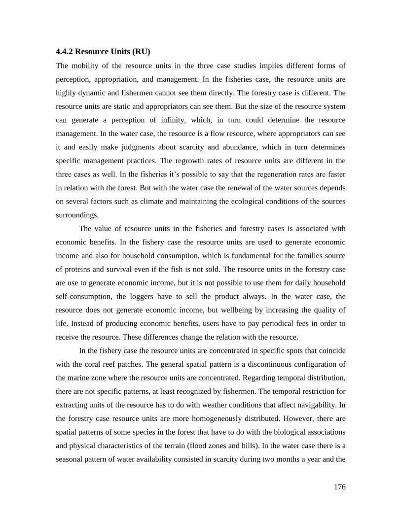
176
4.4.2 Resource Units (RU)
The mobility of the resource units in the three case studies implies different forms of
perception, appropriation, and management. In the fisheries case, the resource units are
highly dynamic and fishermen cannot see them directly. The forestry case is different. The
resource units are static and appropriators can see them. But the size of the resource system
can generate a perception of infinity, which, in turn could determine the resource
management. In the water case, the resource is a flow resource, where appropriators can see
it and easily make judgments about scarcity and abundance, which in turn determines
specific management practices. The regrowth rates of resource units are different in the
three cases as well. In the fisheries it’s possible to say that the regeneration rates are faster
in relation with the forest. But with the water case the renewal of the water sources depends
on several factors such as climate and maintaining the ecological conditions of the sources
surroundings.
The value of resource units in the fisheries and forestry cases is associated with
economic benefits. In the fishery case the resource units are used to generate economic
income and also for household consumption, which is fundamental for the families source
of proteins and survival even if the fish is not sold. The resource units in the forestry case
are use to generate economic income, but it is not possible to use them for daily household
self-consumption, the loggers have to sell the product always. In the water case, the
resource does not generate economic income, but wellbeing by increasing the quality of
life. Instead of producing economic benefits, users have to pay periodical fees in order to
receive the resource. These differences change the relation with the resource.
In the fishery case the resource units are concentrated in specific spots that coincide
with the coral reef patches. The general spatial pattern is a discontinuous configuration of
the marine zone where the resource units are concentrated. Regarding temporal distribution,
there are not specific patterns, at least recognized by fishermen. The temporal restriction for
extracting units of the resource has to do with weather conditions that affect navigability. In
the forestry case resource units are more homogeneously distributed. However, there are
spatial patterns of some species in the forest that have to do with the biological associations
and physical characteristics of the terrain (flood zones and hills). In the water case there is a
seasonal pattern of water availability consisted in scarcity during two months a year and the
177
rest of the year the supply is normal. The source of water for the aqueduct is located in the
upper part of the creek where the inlet is installed, which in turn is feed by the water
accumulation in the higher “paramo” ecosystem.
Table 11. Resource units variables for the three SESs.
RESOURCE UNITS (RU)
FISHERY
FORESTRY WATER
Resource unit
mobility
(RU1)
High mobility
Sedentary
Flow resource
Growth or
replacement
rate
(RU2)
Fast. Fish species regrowth
rates.
Slow. Forest species
regrowht rates. Several
years cycles (7-20 years)
Seasonal, depending on the
climate
Economic value
(RU4)
Prices vary according each
species, being the highest
lobster and shrimp species.
1,5 EUR / kg scaled fish
Depends on the species
Users do not sell water
units. The benefit is
household well-being.
Spatial and
temporal distribution
(RU7)
Discontinuous spatial
distribution
Discontinuous spatial
distribution depending on
the physical
characteristics of the
terrain
Heterogeneous spatial
distribution depending on
the watershed location.
Season dependent temporal
distribution
4.4.3 Governance system (RU)
The forestry and water case have in common that the main governmental formal rules for
the management of the resources are designed and enforced by the regional governmental
agencies in each area (Autonomous Regional Environmental Agencies). In the water case
the Municipality has a relevant role in the facilitation and support for rural aqueducts. In the
forestry case the municipality does not have competency in rural zones. In contrast, in the
fisheries case, the environmental authority is the Natural Park, and also the governmental
agency for the fisheries regulation, which has no presence in the zone. In practice the
Natural Park interacts with fishermen. In the three cases there are community organizations
that influence directly the use and management of the resource: the fishermen association,
which is the weakest, in the forestry case there is the Comunitarian Council (ACAPA), the
most comprehensive in terms of governance because they are in charge of territorial
178
governance, and the Aqueduct Council in the water case, which is the oldest and the most
effective in resource management terms. The presence of NGOs in the three cases is
different. In the water case predominates the local community organization. In the fishery
case there are several NGOs focused in environmental, cultural issues and local
development. In the forestry case there is a high number of humanitarian NGOs and weak
presence of environmental organizations.
In the three cases the networks are based in familiar relations and the main nodes
belong to the oldest families. However, in each case the flows and links have different
meanings. In the forestry case the cultural inheritance that flows through the network is the
basis for the Communitarian Council’ legitimacy. In the fisheries case the cultural aspect is
not as important, instead, the flows of the network conveys other type of information more
practical and linked mainly to economic aspects. In the water case, the interaction among
families is weak due to cultural and geographical aspects, and the network mobilizes
information strictly necessary for collective problems solving.
In the three cases the resources are commons. But the territoriality that each group
of users has developed is different. Lenguazaque (water) has a traditional private land
property regime, that exists at the same time that the common property character of water.
In contrast, Salahonda (forest) has a tradition of private owned parcels with great areas of
land managed as commons where the forest is located. This regime of property rights has
changed, in the last 20 years towards a collective property scheme, which is formalized
with Communitarian Councils. In Barú (fishery) the marine resources have a property
regime that is linked to a specific territoriality traditionally constructed by the locals.
Regarding the rules used to use and manage the resource, in the forestry and water
cases, they have been developed by the community, which is represented by the
Communitarian Council and the Aqueduct Council in the water case. These institutions are
fully recognized by the government. In Baru (fishery) the predominant rules are the ones
proposed by the environmental agency (National Park). The fulfillment of rules, by the
users, in the three cases depends upon different aspects. In the fisheries case, it depends on
the relationships with the National Park officers. In the forestry case the rule compliance is
a function of the Communitarian Council’ legitimacy. In the water case it depends on the
correct functioning of the Aqueduct Council. These are factors that, in the three cases, have
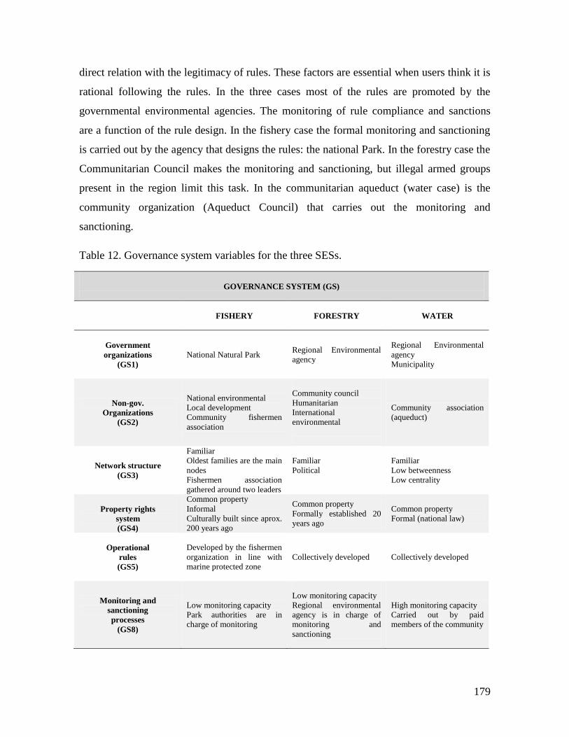
179
direct relation with the legitimacy of rules. These factors are essential when users think it is
rational following the rules. In the three cases most of the rules are promoted by the
governmental environmental agencies. The monitoring of rule compliance and sanctions
are a function of the rule design. In the fishery case the formal monitoring and sanctioning
is carried out by the agency that designs the rules: the national Park. In the forestry case the
Communitarian Council makes the monitoring and sanctioning, but illegal armed groups
present in the region limit this task. In the communitarian aqueduct (water case) is the
community organization (Aqueduct Council) that carries out the monitoring and
sanctioning.
Table 12. Governance system variables for the three SESs.
GOVERNANCE SYSTEM (GS)
FISHERY
FORESTRY WATER
Government
organizations
(GS1)
National Natural Park Regional Environmental
agency
Regional Environmental
agency
Municipality
Non-gov.
Organizations
(GS2)
National environmental
Local development
Community fishermen
association
Community council
Humanitarian
International
environmental
Community association
(aqueduct)
Network structure
(GS3)
Familiar
Oldest families are the main
nodes
Fishermen association
gathered around two leaders
Familiar
Political
Familiar
Low betweenness
Low centrality
Property rights
system
(GS4)
Common property
Informal
Culturally built since aprox.
200 years ago
Common property
Formally established 20
years ago
Common property
Formal (national law)
Operational
rules
(GS5)
Developed by the fishermen
organization in line with
marine protected zone
Collectively developed Collectively developed
Monitoring and
sanctioning
processes
(GS8)
Low monitoring capacity
Park authorities are in
charge of monitoring
Low monitoring capacity
Regional environmental
agency is in charge of
monitoring and
sanctioning
High monitoring capacity
Carried out by paid
members of the community
180
4.4.4 Users (U)
The number of users in the three cases studies ranges from 200 fishermen, approximately
1400 loggers33 and 600 households in the water case. ACAPA’s territory has a population
of approximately 8000 people that derive their livelihoods from forest logging. The UBN34
is useful to compare the three case studies in terms of the socioeconomic characteristics of
users. The index integrates housing conditions, water and sewerage coverage, education
access and income related indicators. The forest users have a UBN35 indicator of 68%,
which means that a high portion of the of the region’s population does not access their basic
livelihoods needs. In contrast, the fishery and water cases have similar UBN percentages
(35,5% and 36,4%) showing that approximately one third of the population in the
respective regions does not have access to basic livelihood needs. These figures can be
compared with the national UBN for Colombia: 53,3%. In the forestry and water case
studies is particularly important the property rights regime. In the forestry case, the land is
collectively owned and consequently the forest. In the water case the land is private and the
properties range between 0,5 and 5 Ha. In the fishery and forestry cases the economic
dependence on the resource is high. In the water case the situation is different because they
do not depend on the aqueduct for their production; the aqueduct generates well being for
the users.
Regarding the history of use, fishery and forestry cases have between 200 and 150
years of traditional use. In the ACAPA’s territory the timber extraction has had three
different periods. The first (1850s-1950s) characterized by small-scale logging, the second
33 According to the National Land Use Planning GIS (SIG-OT http://sigotn.igac.gov.co/sigotn/) ACAPA´s
population is 8106 inhabitants and 1453 households for 2011. There is no data of the number of loggers. I use
the number of households as a proxy assuming that one person by family derives her income from logging.
34 UBN stands for Unsatisfied Basic Needs, which is one of the indexes for poverty measurement. The UBN
methodology uses several indicators to cover a representative set of basic needs. The index is built throughout
a direct multidimensional method (Boltvinik, 1998), meaning that it integrates several dimensions of elements
used to define poverty levels. An UBN value in percentages represents the fraction of the population of a
place that is below the poverty threshold. According to the National Administrative Department of Statistics
(DANE) of Colombia, the index reflects “The groups that do not reach the minimum threshold are classified
as poor. The selected simple indicators are: inadequate housing, housing with critical overcrowding, housing
with inadequate services, households with high levels of economic dependence, and households with school-
age children not enrolled in school” (DANE http://www.dane.gov.co)
35
The UBN values are taken from DANE. The figures correspond to 2005.

181
(1950s-1970s) by a considerable expansion of the activity, and the latest period (1980s-
present) experimented a contraction towards small extraction character again. In the second
phase the introduction of new extraction technologies played a central role in the expansion
of the activity, which was the introduction of the chain saw. In contrast, the water case has
a short history; the aqueduct has 15 years of functioning. The mental models about the
resource system functioning in the fisheries case, currently and from the side of
environmental authorities is consistent with the model of anarchic nature coined by
Gunderson and Holling (2002). In contrast, in the forestry case region traditionally the
mental model about the ecosystems of the SES’ actors has been closer to the balanced
nature. In the water case, the balanced nature is the mental model that has prevailed as well.
In the three cases the leadership has been important for the resource management,
but they have different characteristics. The leadership has been developed recently due to
scarcity problems and state interventions; therefore the leadership is potentialized of
different forms in each case. In the forestry case, the leadership is linked to the
Comunitarian Council’ political interests. The central topic is not the forest but territorial
gobernance, which formally started in 1993 incentivized by the National Government. The
entrepreneurship is a different phenomenon, which started to develop in the second phase
of the use history, in the 1950s. The entrepreneurs are the sawmill owners. These initiatives
have not had a direct connection with the leadership political process mentioned before. In
contrast, in the fishery case the leadership is focused in the entrepreneurship. This condition
implies more conflicts because leaders’ economic interests are highly relevant. This is
evident in the organizational situation of the fishermen association. The water case is
different because the economic interests are not so strong in the aqueduct users’
organization. In this case the indifference regarding collective actions for the resource is
dominant. A common characteristic of the three cases is the short organizational history;
the formal associations in the three studies have no more than 20 years.
With respect to the norms supporting the resource use, in the forestry case, the rules
in used are based on the market, which also is connected with the users’ mental model
(nature balanced) mentioned above. In the fishery and water case the norms are based in the
formal organization for the resource administration. Rule compliance in the three cases is

182
based is linked to social capital levels. However, the water case is different due to the weak
economic incentives when users face the decision of follow or not the rules.
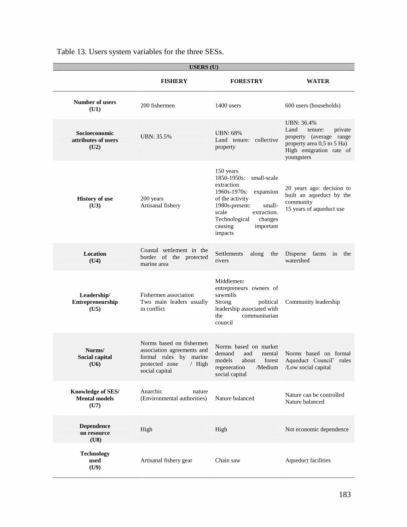
183
Table 13. Users system variables for the three SESs.
USERS (U)
FISHERY
FORESTRY WATER
Number of users
(U1)
200 fishermen 1400 users 600 users (households)
Socioeconomic
attributes of users
(U2)
UBN: 35.5%
UBN: 68%
Land tenure: collective
property
UBN: 36.4%
Land tenure: private
property (average range
property area 0,5 to 5 Ha)
High emigration rate of
youngsters
History of use
(U3)
200 years
Artisanal fishery
150 years
1850-1950s: small-scale
extraction
1960s-1970s: expansion
of the activity
1980s-present: small-
scale extraction.
Technological changes
causing important
impacts
20 years ago: decision to
built an aqueduct by the
community
15 years of aqueduct use
Location
(U4)
Coastal settlement in the
border of the protected
marine area
Settlements along the
rivers
Disperse farms in the
watershed
Leadership/
Entrepreneurship
(U5)
Fishermen association
Two main leaders usually
in conflict
Middlemen:
entrepreneurs owners of
sawmills
Strong political
leadership associated with
the communitarian
council
Community leadership
Norms/
Social capital
(U6)
Norms based on fishermen
association agreements and
formal rules by marine
protected zone / High
social capital
Norms based on market
demand and mental
models about forest
regeneration /Medium
social capital
Norms based on formal
Aqueduct Council’ rules
/Low social capital
Knowledge of SES/
Mental models
(U7)
Anarchic nature
(Environmental authorities)
Nature balanced Nature can be controlled
Nature balanced
Dependence
on resource
(U8)
High High Not economic dependence
Technology
used
(U9)
Artisanal fishery gear
Chain saw Aqueduct facilities
184
4.4.5 Interactions (I)
In the fishery case there are evidences of resource scarcity due to overharvesting in the
fishery spots close to the shore by artisanal fishery and also by industrial fisheries in more
depth waters. In the forestry case there is a perception and concern about some species.
Also there are evidences of timber extraction below the minimum sizes. In the water case,
there is a generalized perception of resource decreasing due to climate variability. The
shared information, in this case, is focused in the communitarian infrastructure (aqueduct).
This is that the aqueduct association has meetings with all the users each six months where
issues about finances, fees and infrastructure maintenance are discussed. In the other two
cases the shared information is related with resource extraction conditions. In the forestry
the shared information has to do mainly with timber prices. In the fishery the shared
information is about fishery spots conditions and species prices.
Deliberation spaces are different in the three cases. In the fishery the deliberation is
marked by productive interests, in the forestry they are motivated by territorial governance
and in the water case are focused in the infrastructure maintenance. In the water case the
conflicts are related with the occasional rule breaking. In the fishery place there are
important conflicts among the leaders of the fishermen association about the organization
management and financial aspects. The other important conflict is between the fishermen
and the marine protected area administration. In the forestry region the conflicts are among
leaders, but the motivations have to do with the territorial governance and not specifically
around the forest. One of the common conflicting issues is the corruption among leaders.
But the most serious conflicts are with the illegal armed groups for territorial governance.
Investment in infrastructure is usually important to maintain the provision and
appropriation of a RUC. In the aqueduct case the investment in the communitarian
infrastructure is dominant, while in the other two cases the investment is for improving the
productive activities. In the forestry case the investment that generates collective benefits is
carried out at private level (sawmills). The lobby activities in the fishery case are made
mainly with local development NGOs. In the aqueduct case the lobby is predominantly
with the State (Municipality). In the forestry case the lobby activities take place in both
fields.
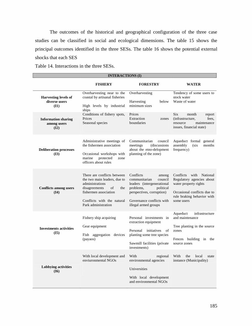
185
The outcomes of the historical and geographical configuration of the three case
studies can be classified in social and ecological dimensions. The table 15 shows the
principal outcomes identified in the three SESs. The table 16 shows the potential external
shocks that each SES
Table 14. Interactions in the three SESs.
INTERACTIONS (I)
FISHERY
FORESTRY WATER
Harvesting levels of
diverse users
(I1)
Overharvesting near to the
coastal by artisanal fisheries
High levels by industrial
ships
Overharvesting
Harvesting below
minimum sizes
Tendency of some users to
stock water
Waste of water
Information sharing
among users
(I2)
Conditions of fishery spots,
Prices
Seasonal species
Prices
Extraction zones
boundaries
Six month report
(infrastructure, fees,
resource maintenance
issues, financial state)
Deliberation processes
(I3)
Administrative meetings of
the fishermen association
Occasional workshops with
marine protected zone
officers about rules
Communitarian council
meetings (discussions
about the etno-delopment
planning of the zone)
Aqueduct formal general
assembly (six months
frequency)
Conflicts among users
(I4)
There are conflicts between
the two main leaders, due to
administrations
disagreements of the
fishermen association
Conflicts with the natural
Park administration
Conflicts among
communitarian council
leaders (intergenerational
problems, political
perspectives, corruption)
Governance conflicts with
illegal armed groups
Conflicts with National
Regulatory agencies about
water property rights
Occasional conflicts due to
rule braking behavior with
some users
Investments activities
(I5)
Fishery ship acquiring
Gear equipment
Fish aggregation devices
(payaos)
Personal investments in
extraction equipment
Personal initiatives of
planting some tree species
Sawmill facilities (private
investments)
Aqueduct infrastructure
and maintenance
Tree planting in the source
zones
Fences building in the
source zones
Lobbying activities
(I6)
With local development and
enviuronmental NGOs
With regional
environmental agencies
Universities
With local development
and environmental NGOs
With the local state
instance (Municipality)
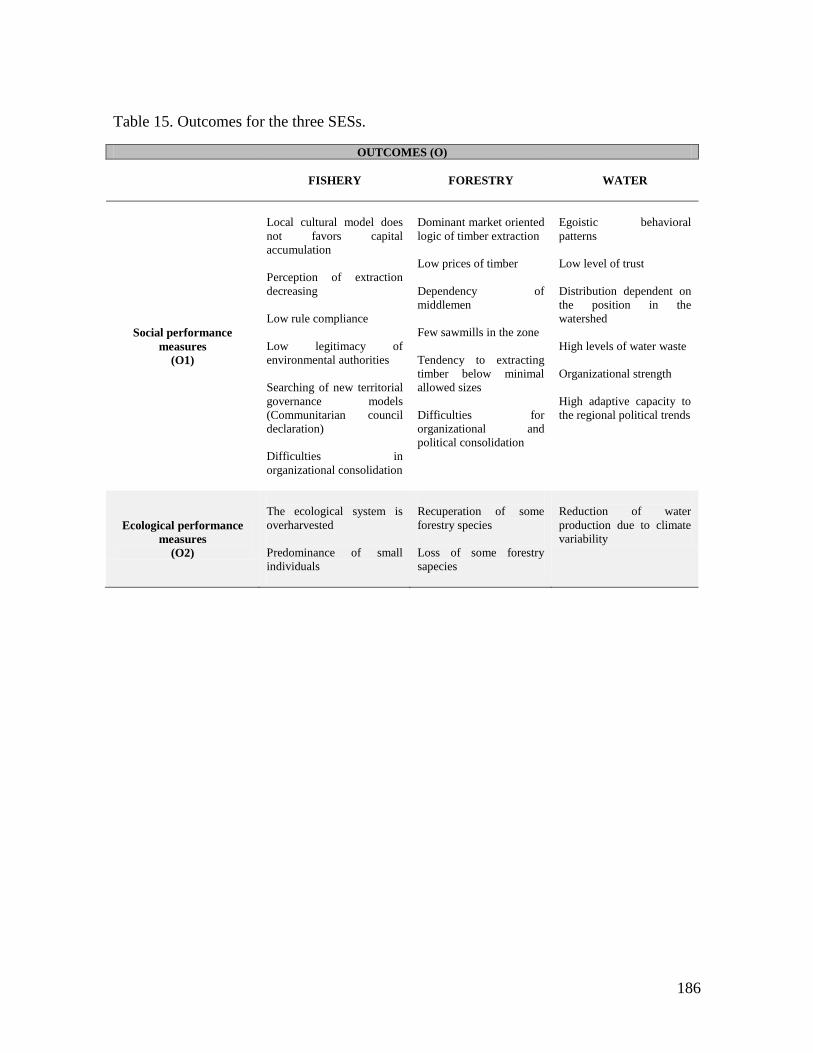
186
Table 15. Outcomes for the three SESs.
OUTCOMES (O)
FISHERY
FORESTRY WATER
Social performance
measures
(O1)
Local cultural model does
not favors capital
accumulation
Perception of extraction
decreasing
Low rule compliance
Low legitimacy of
environmental authorities
Searching of new territorial
governance models
(Communitarian council
declaration)
Difficulties in
organizational consolidation
Dominant market oriented
logic of timber extraction
Low prices of timber
Dependency of
middlemen
Few sawmills in the zone
Tendency to extracting
timber below minimal
allowed sizes
Difficulties for
organizational and
political consolidation
Egoistic behavioral
patterns
Low level of trust
Distribution dependent on
the position in the
watershed
High levels of water waste
Organizational strength
High adaptive capacity to
the regional political trends
Ecological performance
measures
(O2)
The ecological system is
overharvested
Predominance of small
individuals
Recuperation of some
forestry species
Loss of some forestry
sapecies
Reduction of water
production due to climate
variability
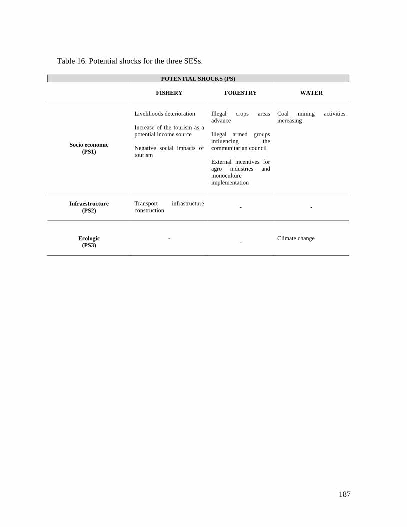
187
Table 16. Potential shocks for the three SESs.
POTENTIAL SHOCKS (PS)
FISHERY
FORESTRY WATER
Socio economic
(PS1)
Livelihoods deterioration
Increase of the tourism as a
potential income source
Negative social impacts of
tourism
Illegal crops areas
advance
Illegal armed groups
influencing the
communitarian council
External incentives for
agro industries and
monoculture
implementation
Coal mining activities
increasing
Infraestructure
(PS2)
Transport infrastructure
construction
- -
Ecologic
(PS3)
-
-
Climate change
188
5 INSTITUTIONAL ANALYSIS
The chapter 4 addressed the question about the definition of each case study SES. To reach
such definition it was necessary to understand geographical and historical contexts of the
case studies. The conclusion of the contextual chapter, trough out a comparison of the three
SESs, remarks the importance of the subsystems and variables that constitute the focus of
the chapters 5 and 6 of this dissertation. The focuses of these two chapters are the
governance and users subsystems. Consequently, in this chapter, an analysis of the
governance systems is done through the IAD framework.
This chapter is divided in five sections. In the first section I make a brief discussion
about the outcomes of the action arena in which I will focus of the institutional analysis,
which already has discussed in chapter 2, focused on rules and norms typology and
outcomes of the action situation. In the following three sections I develop the analysis of
each of the case studies done with the data collected in experiments, RPG collective
construction and playing, surveys and interviews and the information from the context
(chapter 4). Each case study starts with the action situation and its outcomes at the scale of
the economic experiment; the next subsection addresses the collective construction of the
RPG and the outcomes of the RPG action situation. In the next section the outcomes of the
SES are studied in terms of cooperation, trust and general morality conformance. Finally, a
summary of the main findings for each case is carried out. In the last section of the chapter
I compare the three case studies and synthesize the main findings.
| It is important to remark that across the chapter I will refer to three action arenas:
experimental, RPG and SES, being the last the one in which fishermen, forest users and
aqueduct users are immersed in their daily life. Experiments and RPGs are models of the
SES with different levels of complexity. Starting with the experimental structure analysis
we can have a controllable reference point, to continue with the role game as an
189
intermediate step to address the social ecological system’s structure. This procedure allows
us to gradually address and better understand complexity of the commons situation we are
analyzing. The process entails a scaling up approach in which each level helps to
understand the level above. I use the collectively designed RPG to describe and analyze the
action arena of the three case studies. In the first place I summarize the essential problem
addressed in each case. I start with the analytical description of the board game, which in
the three case studies, presents a fundamental anchoring point for local commons problem.
The collective construction of the RPG and implementation works as a talking device
uncovering the main problems of the SES. This process is done guided by the elements of
the action arena already discussed in chapter 2.
Through the examination of rules I illustrated how they affect each component of
the action situation. In order to evaluate the outcomes that these institutional arrangements
produce I discuss the criteria for their evaluation, which permits us to define outcome
variables. Extraction of resource units accounts for participants' behavior, and it is possible
to assess this behavior in experiments and role games. The state of the resource is one of
the most important criteria for the sustainability of the socio-ecological system, and it is
discussed as an outcome of the experimental and RPG action arena. Economic efficiency is
evaluated through payoffs in the experiments and RPG. Trust and cooperation are discussed
as outcomes from experiments and RPG and the relation with the SES context. To these
traditional evaluative criteria of the outcome variables, I add conformity to general
morality. The level of conformity to the general morality is interpreted as the consequence
of the dynamics of a given set of institutional arrangements, rather than as an external
condition of the action arena´s outcomes. In chapter 2, section 2.4.2, I developed a
conceptual framework for the evaluation of this variable. In the next paragraphs I briefly
explain the role of the morality dimension in the analysis. In the conceptual chapter I
introduced the general morality conformance as an evaluative criterion for action arena’s
outcomes. As a consequence of the analysis I propose that morality constitutes part of the
outcomes themselves that reinforces the action arena working as a dynamic feedback loop.
In this sense cooperation and trust are a function of the general morality conformance
constructed through time in a community and the different action arenas in which common
pool resources users are embedded could constantly reinforce that. A given set of
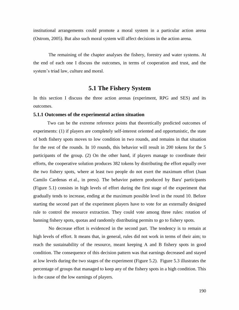
190
institutional arrangements could promote a moral system in a particular action arena
(Ostrom, 2005). But also such moral system will affect decisions in the action arena.
The remaining of the chapter analyses the fishery, forestry and water systems. At
the end of each one I discuss the outcomes, in terms of cooperation and trust, and the
system’s triad law, culture and moral.
5.1 The Fishery System
In this section I discuss the three action arenas (experiment, RPG and SES) and its
outcomes.
5.1.1 Outcomes of the experimental action situation
Two can be the extreme reference points that theoretically predicted outcomes of
experiments: (1) if players are completely self-interest oriented and opportunistic, the state
of both fishery spots moves to low condition in two rounds, and remains in that situation
for the rest of the rounds. In 10 rounds, this behavior will result in 200 tokens for the 5
participants of the group. (2) On the other hand, if players manage to coordinate their
efforts, the cooperative solution produces 382 tokens by distributing the effort equally over
the two fishery spots, where at least two people do not exert the maximum effort (Juan
Camilo Cardenas et al., in press). The behavior pattern produced by Baru' participants
(Figure 5.1) consists in high levels of effort during the first stage of the experiment that
gradually tends to increase, ending at the maximum possible level in the round 10. Before
starting the second part of the experiment players have to vote for an externally designed
rule to control the resource extraction. They could vote among three rules: rotation of
banning fishery spots, quotas and randomly distributing permits to go to fishery spots.
No decrease effort is evidenced in the second part. The tendency is to remain at
high levels of effort. It means that, in general, rules did not work in terms of their aim; to
reach the sustainability of the resource, meant keeping A and B fishery spots in good
condition. The consequence of this decision pattern was that earnings decreased and stayed
at low levels during the two stages of the experiment (Figure 5.2). Figure 5.3 illustrates the
percentage of groups that managed to keep any of the fishery spots in a high condition. This
is the cause of the low earnings of players.
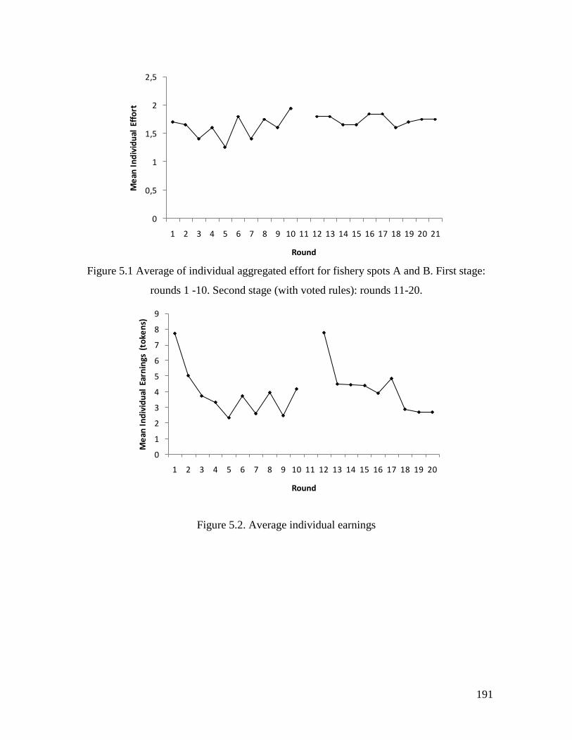
191
Figure 5.1 Average of individual aggregated effort for fishery spots A and B. First stage:
rounds 1 -10. Second stage (with voted rules): rounds 11-20.
Figure 5.2. Average individual earnings
0
0,5
1
1,5
2
2,5
1 2 3 4 5 6 7 8 9 10 11 12 13 14 15 16 17 18 19 20 21
Me
an I
nd
ivid
ual
Eff
ort
Round
0
1
2
3
4
5
6
7
8
9
1 2 3 4 5 6 7 8 9 10 11 12 13 14 15 16 17 18 19 20
Me
an I
nd
ivid
ual
Ear
nin
gs (
toke
ns)
Round
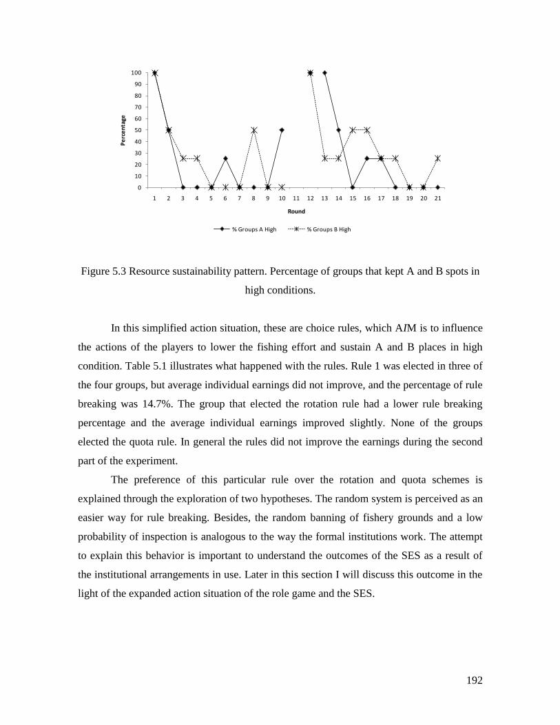
192
Figure 5.3 Resource sustainability pattern. Percentage of groups that kept A and B spots in
high conditions.
In this simplified action situation, these are choice rules, which AIM is to influence
the actions of the players to lower the fishing effort and sustain A and B places in high
condition. Table 5.1 illustrates what happened with the rules. Rule 1 was elected in three of
the four groups, but average individual earnings did not improve, and the percentage of rule
breaking was 14.7%. The group that elected the rotation rule had a lower rule breaking
percentage and the average individual earnings improved slightly. None of the groups
elected the quota rule. In general the rules did not improve the earnings during the second
part of the experiment.
The preference of this particular rule over the rotation and quota schemes is
explained through the exploration of two hypotheses. The random system is perceived as an
easier way for rule breaking. Besides, the random banning of fishery grounds and a low
probability of inspection is analogous to the way the formal institutions work. The attempt
to explain this behavior is important to understand the outcomes of the SES as a result of
the institutional arrangements in use. Later in this section I will discuss this outcome in the
light of the expanded action situation of the role game and the SES.
0
10
20
30
40
50
60
70
80
90
100
1 2 3 4 5 6 7 8 9 10 11 12 13 14 15 16 17 18 19 20 21
Pe
rce
nta
ge
Round
% Groups A High % Groups B High
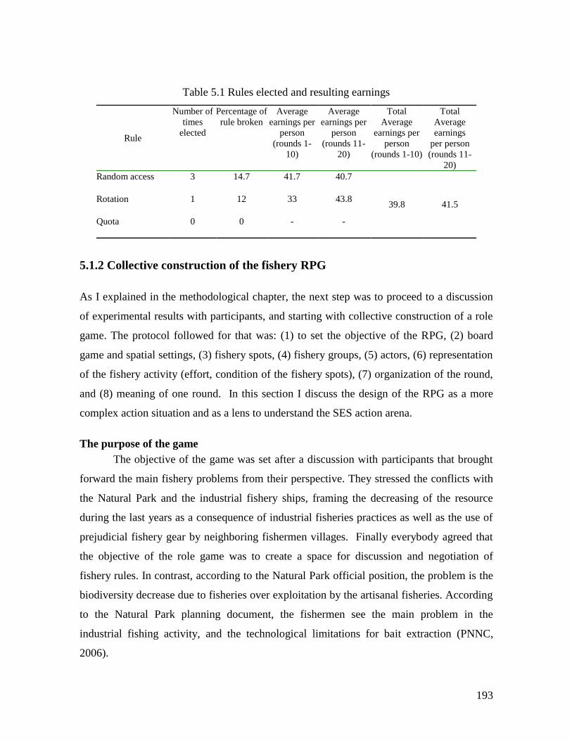
193
Table 5.1 Rules elected and resulting earnings
Rule
Number of
times
elected
Percentage of
rule broken
Average
earnings per
person
(rounds 1-
10)
Average
earnings per
person
(rounds 11-
20)
Total
Average
earnings per
person
(rounds 1-10)
Total
Average
earnings
per person
(rounds 11-
20)
Random access
3 14.7 41.7 40.7
39.8 41.5 Rotation
1 12 33 43.8
Quota
0 0 - -
5.1.2 Collective construction of the fishery RPG
As I explained in the methodological chapter, the next step was to proceed to a discussion
of experimental results with participants, and starting with collective construction of a role
game. The protocol followed for that was: (1) to set the objective of the RPG, (2) board
game and spatial settings, (3) fishery spots, (4) fishery groups, (5) actors, (6) representation
of the fishery activity (effort, condition of the fishery spots), (7) organization of the round,
and (8) meaning of one round. In this section I discuss the design of the RPG as a more
complex action situation and as a lens to understand the SES action arena.
The purpose of the game
The objective of the game was set after a discussion with participants that brought
forward the main fishery problems from their perspective. They stressed the conflicts with
the Natural Park and the industrial fishery ships, framing the decreasing of the resource
during the last years as a consequence of industrial fisheries practices as well as the use of
prejudicial fishery gear by neighboring fishermen villages. Finally everybody agreed that
the objective of the role game was to create a space for discussion and negotiation of
fishery rules. In contrast, according to the Natural Park official position, the problem is the
biodiversity decrease due to fisheries over exploitation by the artisanal fisheries. According
to the Natural Park planning document, the fishermen see the main problem in the
industrial fishing activity, and the technological limitations for bait extraction (PNNC,
2006).
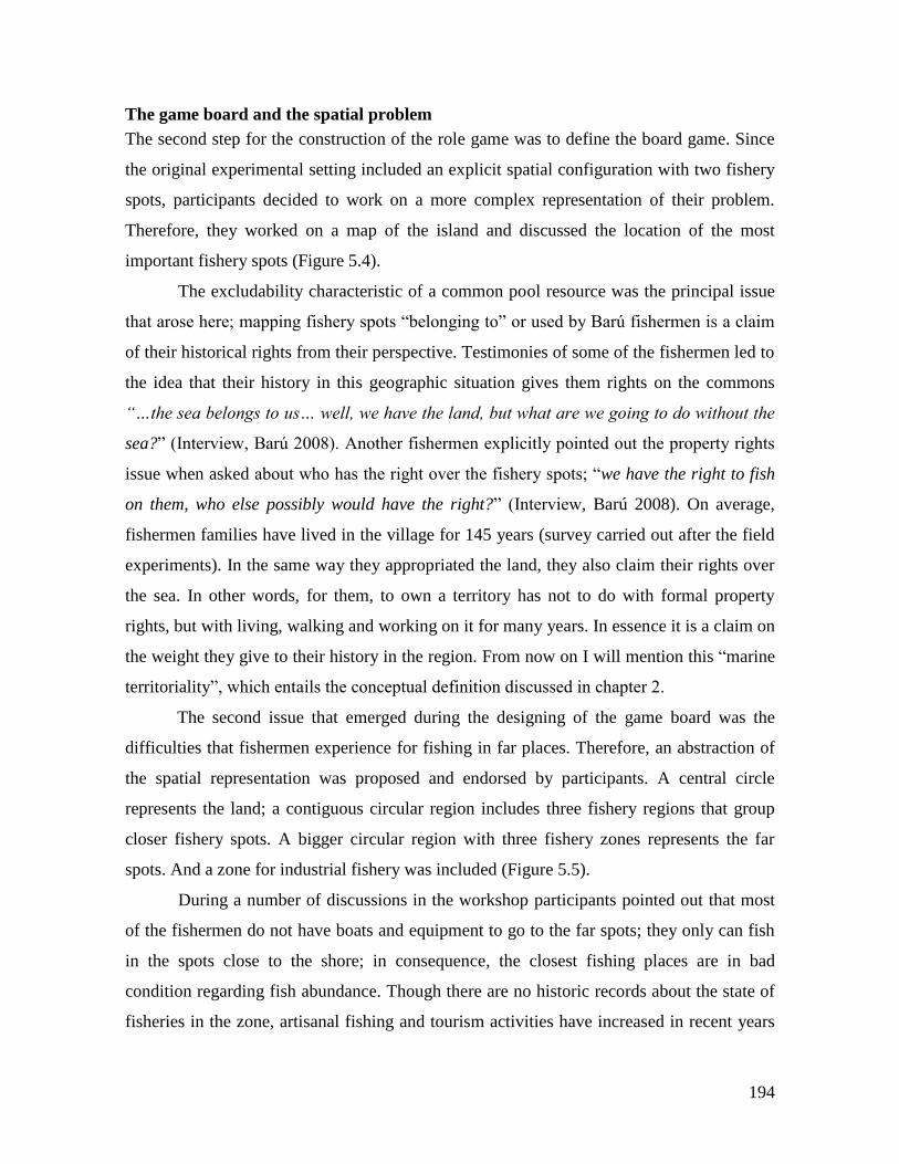
194
The game board and the spatial problem
The second step for the construction of the role game was to define the board game. Since
the original experimental setting included an explicit spatial configuration with two fishery
spots, participants decided to work on a more complex representation of their problem.
Therefore, they worked on a map of the island and discussed the location of the most
important fishery spots (Figure 5.4).
The excludability characteristic of a common pool resource was the principal issue
that arose here; mapping fishery spots “belonging to” or used by Barú fishermen is a claim
of their historical rights from their perspective. Testimonies of some of the fishermen led to
the idea that their history in this geographic situation gives them rights on the commons
“…the sea belongs to us… well, we have the land, but what are we going to do without the
sea?” (Interview, Barú 2008). Another fishermen explicitly pointed out the property rights
issue when asked about who has the right over the fishery spots; “we have the right to fish
on them, who else possibly would have the right?” (Interview, Barú 2008). On average,
fishermen families have lived in the village for 145 years (survey carried out after the field
experiments). In the same way they appropriated the land, they also claim their rights over
the sea. In other words, for them, to own a territory has not to do with formal property
rights, but with living, walking and working on it for many years. In essence it is a claim on
the weight they give to their history in the region. From now on I will mention this “marine
territoriality”, which entails the conceptual definition discussed in chapter 2.
The second issue that emerged during the designing of the game board was the
difficulties that fishermen experience for fishing in far places. Therefore, an abstraction of
the spatial representation was proposed and endorsed by participants. A central circle
represents the land; a contiguous circular region includes three fishery regions that group
closer fishery spots. A bigger circular region with three fishery zones represents the far
spots. And a zone for industrial fishery was included (Figure 5.5).
During a number of discussions in the workshop participants pointed out that most
of the fishermen do not have boats and equipment to go to the far spots; they only can fish
in the spots close to the shore; in consequence, the closest fishing places are in bad
condition regarding fish abundance. Though there are no historic records about the state of
fisheries in the zone, artisanal fishing and tourism activities have increased in recent years
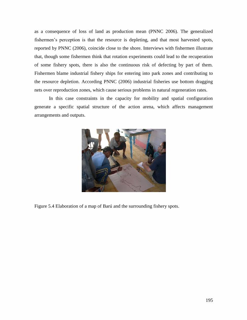
195
as a consequence of loss of land as production mean (PNNC 2006). The generalized
fishermen’s perception is that the resource is depleting, and that most harvested spots,
reported by PNNC (2006), coincide close to the shore. Interviews with fishermen illustrate
that, though some fishermen think that rotation experiments could lead to the recuperation
of some fishery spots, there is also the continuous risk of defecting by part of them.
Fishermen blame industrial fishery ships for entering into park zones and contributing to
the resource depletion. According PNNC (2006) industrial fisheries use bottom dragging
nets over reproduction zones, which cause serious problems in natural regeneration rates.
In this case constraints in the capacity for mobility and spatial configuration
generate a specific spatial structure of the action arena, which affects management
arrangements and outputs.
Figure 5.4 Elaboration of a map of Barú and the surrounding fishery spots.
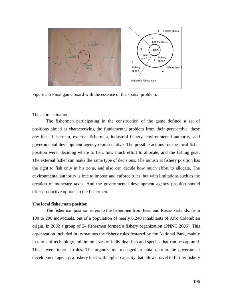
196
Figure 5.5 Final game board with the essence of the spatial problem.
The action situation
The fishermen participating in the construction of the game defined a set of
positions aimed at characterizing the fundamental problem from their perspective, these
are: local fisherman, external fisherman, industrial fishery, environmental authority, and
governmental development agency representative. The possible actions for the local fisher
position were: deciding where to fish, how much effort to allocate, and the fishing gear.
The external fisher can make the same type of decisions. The industrial fishery position has
the right to fish only in his zone, and also can decide how much effort to allocate. The
environmental authority is free to impose and enforce rules, but with limitations such as the
creation of monetary taxes. And the governmental development agency position should
offer productive options to the fishermen.
The local fisherman position
The fisherman position refers to the fishermen from Barú and Rosario islands, from
100 to 200 individuals, out of a population of nearly 6,240 inhabitants of Afro Colombian
origin. In 2002 a group of 24 fishermen formed a fishery organization (PNNC 2006). This
organization included in its statutes the fishery rules fostered by the National Park, mainly
in terms of technology, minimum sizes of individual fish and species that can be captured.
Those were internal rules. The organization managed to obtain, from the government
development agency, a fishery boat with higher capacity that allows travel to further fishery
Land
1
2
3
5
6
4
Industrial fishery zone
Fishery spot 1
Fishery spot 4
Fishery spot 5
Fishery spot 2
Fishery spot 3
Fishery spot 6
197
grounds. In addition, the organization obtained support for building fish aggregation
devices in order to improve harvest and protect coral reef fishery spots.
From the National Park’s perspective, Barú and fishermen from neighboring
villages belong to a community relatively homogeneous in terms of socio economical
aspects with low incomes and high poverty indexes. Internal heterogeneity starts to be
evident by looking at data from the survey applied at the end of the experiments. For
example the 30% of participants in the experiments allocate most of their time to
agricultural activities while a 60% work mainly in fishery. Regarding the main sources of
income, 43% declare that their main economic activity is not form fishing, and it is
distributed among handicrafts, small businesses including tourism, and diverse
employments, part of them related to tourism activities and agriculture. From interview data
and direct field observation it is evident that there are differences in wealth and access to
information among members of the fishermen community.
As a consequence of the internal heterogeneity among Baru fishermen, positions
and actions in the SES, could include small tourism operators and farmers for example.
This diversity of positions has an effect on the outcome of the action situation shown
below.
External fishermen position
External fishermen position is aimed to represent fishermen from neighboring
villages. Participants who can occupy this position, from Barú fishermen’s perspective, are
the fishermen from at least three different villages in the zone and from the city of
Cartagena. While role game designers make a clear differentiation between these two
positions, the governmental environmental entity has a different point of view in which all
the artisanal fishermen from the different villages in the zone, even from Cartagena city,
have the same attributes and the same access rights. Therefore, for the National Park
authorities the only possible position in this action situation is “artisanal fishermen”.
Through the explanation of this position participants expressed their territorial model;
which entails a notion of marine territoriality, in contrast with the governmental
construction of territory that excludes the sea. For the environmental authority (National
Park) the existence of a concept such as marine territoriality is not possible, at least within
the limits of the park. Actions attached to this position are of course fishing effort,
198
harvesting and fishing spot choosing. But there are limitations. In the game board they
explicitly leave a fishing spots without name because “these are the places for fishermen
from other parts”, therefore, for them, again the access to the commons is limited. In
addition to that they blame neighbor fishermen for using illegal fishing gear.
This difference in the conceptualization of the commons dilemma, far from being
superficial, entails one of the dimensions of the cognitive conflict that starts to emerge in
this phase. It shapes the institutional problem, which drives most of the outcomes of the
action situation.
Industrial fishery position
The industrial fishery position can be filled only by ship captains and operators.
Here they conceptualize the problem of territorial invasion and prejudicial fishery practices
as dependent upon the ships themselves. Game designers do not up-scale to see a set of
participants that are at the level of regional, national and even international companies. For
this position the possible actions are to fish out of the Park and far from the artisanal fishing
grounds.
According to environmental authority industrial fisheries affect the park ecosystems
by harvesting with dragging nets over zones that are important for species reproduction
(PNNC 2006). Baru fishermen coincide with this vision, but in addition, they think there is
corruption when the environmental authority applies sanctions, and they say that the law is
not equal for all. This situation contributes to the level of general morality produced when
inequity in rule enforcement is a common practice.
Environmental authority position
Environmental authority is free to impose and enforce rules in the RPG. The Natural
Park was created in 1997, and has an area of 120,000 marine Ha. The Park has around 20
officials, including professionals (biologists, social workers) and technicians whose tasks
consist of the monitoring of Park’s territory surveillance among other technical duties.
Between 2000 and 2004 the Park’s management style was oriented towards participatory
approaches trying to build a close relationship with local communities. Many of the rules
were established in consensus with the local fishermen (Interview with a Park official, Barú
10/07/2008). Even the internal rules of the local fishermen’s association were designed
199
according to the Park’s proposals and the Ministry of Environment’s laws (Interview with a
fisherman, Barú, 4/07/08). In 2004 the National Parks’ central headquarters changed its
policy and the director of the Park was replaced by a military one. This new administration
changed its policies favoring the top-down style of rule creation, monitoring and
enforcement. As a consequence, the relationship with the community deteriorated and the
previous administration’s work on rule agreements and awareness has been lost. Currently,
the general attitude of local inhabitants towards the Park authorities is characterized by
hostility, and interference with any of the Park’s proposals; a situation that has led to
conflicts, with fishermen in general, and especially with the fishermen’ organization.
Information available to participants
The role game provided a representation from the game designers’ perspective on
what information is available for each position in the SES fishing action situation.
Available information for fishermen, on the one hand, is the possible harvest according to
the type of fishery gear chosen, and on the other hand, the total amount of extracted fish for
each fishery spot displayed in the board game each five rounds (Table 5.2 and Figure 5.5).
Fishermen know how the resource changes from a good condition spot to a low condition
spot, and vice versa, depending on the previous total catch. A spot in good condition
changes to low condition, if more than 30 kg of fish are extracted; no matter the number of
rounds the spot has lasted with this amount of extraction. If 10 kg or less of fish is extracted
from a place in bad condition, it moves to a good condition. Neighboring villages and
industrial fishermen have the same information. In contrast with the fishery experiment,
participants in the role game can communicate among themselves without any restriction.
In the SES, information can be classified as: the resource system, others’ actions,
and formal rules. Local knowledge about the state of the resource is passed from generation
to generation and updated by self-experience. Environmental and catch indicators are most
often mentioned by fishermen, but also young fishermen seem to be very influenced by the
opinions of elders. Older fishermen constantly talk about the much better conditions of the
fishing in previous generations, this idea is held by young fishermen. It is not clear how the
information flows among fishermen. From interviews, one can infer that part of the
information about other's actions spread by worth of mouth, mostly information concerning
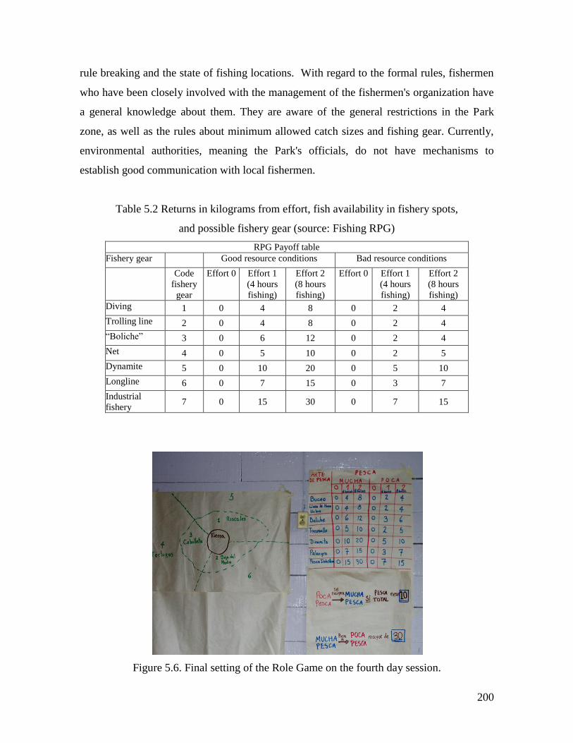
200
rule breaking and the state of fishing locations. With regard to the formal rules, fishermen
who have been closely involved with the management of the fishermen's organization have
a general knowledge about them. They are aware of the general restrictions in the Park
zone, as well as the rules about minimum allowed catch sizes and fishing gear. Currently,
environmental authorities, meaning the Park's officials, do not have mechanisms to
establish good communication with local fishermen.
Table 5.2 Returns in kilograms from effort, fish availability in fishery spots,
and possible fishery gear (source: Fishing RPG)
RPG Payoff table
Fishery gear Good resource conditions Bad resource conditions
Code
fishery
gear
Effort 0 Effort 1
(4 hours
fishing)
Effort 2
(8 hours
fishing)
Effort 0 Effort 1
(4 hours
fishing)
Effort 2
(8 hours
fishing)
Diving 1 0 4 8 0 2 4
Trolling line 2 0 4 8 0 2 4
“Boliche” 3 0 6 12 0 2 4
Net 4 0 5 10 0 2 5
Dynamite 5 0 10 20 0 5 10
Longline 6 0 7 15 0 3 7
Industrial
fishery 7 0 15 30 0 7 15
Figure 5.6. Final setting of the Role Game on the fourth day session.
201
Control over outcomes
Players in the RPG are able to communicate between themselves and with the
environmental authority officer. Theoretically, players (fishermen) have complete control
over the outcomes, and conditions are given for agreement and rule crafting in order to
improve the state of the resource and the benefits. Regarding the SES, the interviewees are
in concur, when asked about the ability to change rules, they give answers such as: "we try
(to change some things) but it's not possible". They have never thought in organizing to
change the rules, and in this way improve some outcomes. One of the fishermen expressed
his point of view about this point. He said that the way to change rules and outcomes also
involves the fish buyers, middlemen, and touristic operators. Regarding the local leaders,
and their role in controlling outcomes of the system, the same interviewee, explains that in
order to improve outcomes they should help. What happens in reality is that "once a person
catches a public post", he has a stable income and is not a fisherman anymore, he does not
care anymore about the community, and the community does not support him. When asked
about rule changing the interviewees do not think of changing formal rules as a way to
improve outcomes. They insist in a different way of rule enforcement and better rule
compliance. The response to the survey question (individual survey applied after
experiments) "How much influence do you believe people like you have in making this a
better place to live by this course?" could be a proxy of the ideas that people have about
controlling outcomes. Sixty percent (60.6%) of the respondents answered that they
influence a lot in their community, 23% said they have some influence, and 17% answered
that they do not influence much. One can understand these figures as a sign of awareness of
the high potential for changing outcomes in the community, but also as the existence of
cultural and moral elements that play an important role in the action arena dynamics, and
that will be discussed in the outcomes section.
Synthesis of the collective construction of the RPG’s action situation
Table 5.3 summarizes a comparison between expected changes and actual changes
that occurred during the building of the game. It shows the important contextual
dimensions that need to be taken into account to model the social dilemma. Resource
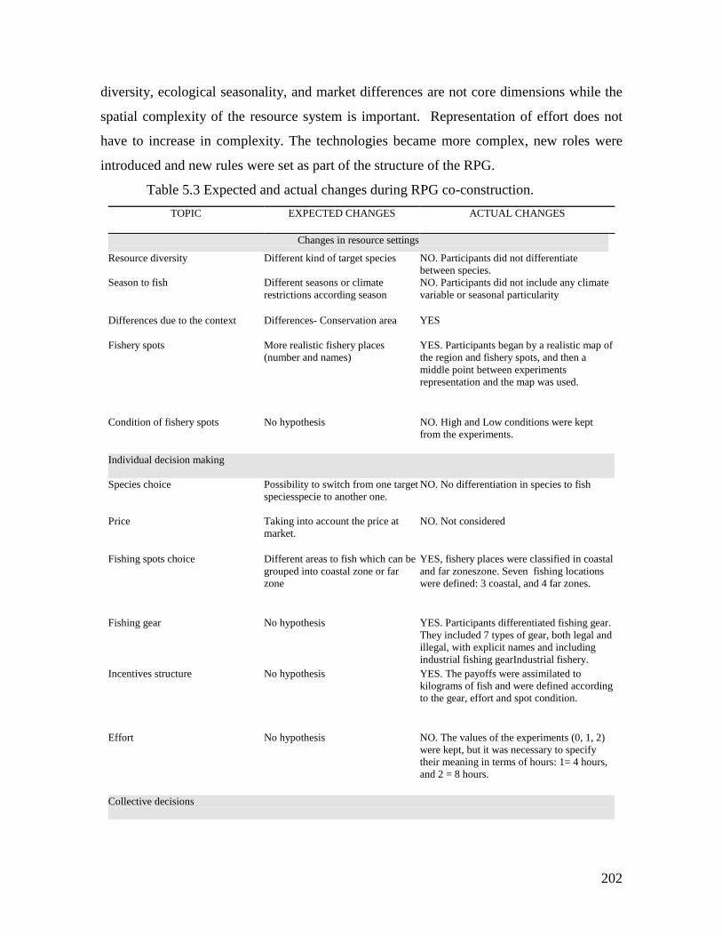
202
diversity, ecological seasonality, and market differences are not core dimensions while the
spatial complexity of the resource system is important. Representation of effort does not
have to increase in complexity. The technologies became more complex, new roles were
introduced and new rules were set as part of the structure of the RPG.
Table 5.3 Expected and actual changes during RPG co-construction.
TOPIC
EXPECTED CHANGES ACTUAL CHANGES
Changes in resource settings
Resource diversity
Different kind of target species
NO. Participants did not differentiate
between species.
Season to fish Different seasons or climate
restrictions according season
NO. Participants did not include any climate
variable or seasonal particularity
Differences due to the context Differences- Conservation area
YES
Fishery spots More realistic fishery places
(number and names)
YES. Participants began by a realistic map of
the region and fishery spots, and then a
middle point between experiments
representation and the map was used.
Condition of fishery spots
No hypothesis NO. High and Low conditions were kept
from the experiments.
Individual decision making
Species choice Possibility to switch from one target
speciesspecie to another one.
NO. No differentiation in species to fish
Price Taking into account the price at
market.
NO. Not considered
Fishing spots choice Different areas to fish which can be
grouped into coastal zone or far
zone
YES, fishery places were classified in coastal
and far zoneszone. Seven fishing locations
were defined: 3 coastal, and 4 far zones.
Fishing gear
No hypothesis YES. Participants differentiated fishing gear.
They included 7 types of gear, both legal and
illegal, with explicit names and including
industrial fishing gearIndustrial fishery.
Incentives structure
No hypothesis YES. The payoffs were assimilated to
kilograms of fish and were defined according
to the gear, effort and spot condition.
Effort
No hypothesis NO. The values of the experiments (0, 1, 2)
were kept, but it was necessary to specify
their meaning in terms of hours: 1= 4 hours,
and 2 = 8 hours.
Collective decisions
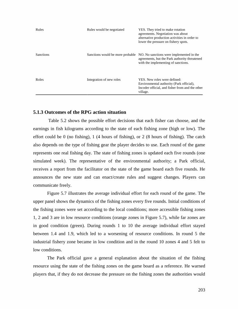
203
Rules Rules would be negotiated YES. They tried to make rotation
agreements. Negotiation was about
alternative production activities in order to
lower the pressure on fishery spots.
Sanctions Sanctions would be more probable NO. No sanctions were implemented in the
agreements, but the Park authority threatened
with the implementing of sanctions.
Roles Integration of new roles YES. New roles were defined:
Environmental authority (Park official),
Incoder official, and fisher from and the other
village.
5.1.3 Outcomes of the RPG action situation
Table 5.2 shows the possible effort decisions that each fisher can choose, and the
earnings in fish kilograms according to the state of each fishing zone (high or low). The
effort could be 0 (no fishing), 1 (4 hours of fishing), or 2 (8 hours of fishing). The catch
also depends on the type of fishing gear the player decides to use. Each round of the game
represents one real fishing day. The state of fishing zones is updated each five rounds (one
simulated week). The representative of the environmental authority; a Park official,
receives a report from the facilitator on the state of the game board each five rounds. He
announces the new state and can enact/create rules and suggest changes. Players can
communicate freely.
Figure 5.7 illustrates the average individual effort for each round of the game. The
upper panel shows the dynamics of the fishing zones every five rounds. Initial conditions of
the fishing zones were set according to the local conditions; more accessible fishing zones
1, 2 and 3 are in low resource conditions (orange zones in Figure 5.7), while far zones are
in good condition (green). During rounds 1 to 10 the average individual effort stayed
between 1.4 and 1.9, which led to a worsening of resource conditions. In round 5 the
industrial fishery zone became in low condition and in the round 10 zones 4 and 5 felt to
low conditions.
The Park official gave a general explanation about the situation of the fishing
resource using the state of the fishing zones on the game board as a reference. He warned
players that, if they do not decrease the pressure on the fishing zones the authorities would
204
have to take actions. During the second week the Park official asked for the presence of a
representative of the governmental agency for rural development and fisheries (INCODER)
in order to give productive alternatives to fishermen to diminish the harvesting pressure on
the closest fishery spots. Therefore, during the process a new position was created in the
RPG’s action arena. A representative of the Colombian public agency in charge of rural
development policies filled this position. Their possible actions were offering productive
alternatives to fishermen different from fishing.
The participant for this position is the Colombian Institute for Rural Development
(INCODER), which is the responsible for the implementation of the agrarian, and
development policies. Among its functions are the facilitation of access to means of
production and the coordination of development efforts among different governmental
agencies and communities. Contributing to the amelioration of the livelihoods of rural
inhabitants is among its ultimate objectives. The agency also is in charge of fishing
regulation and development outside of the protected natural areas (INCODER).
In 2006 the INCODER gave a number of medium capacity fishing boats and
equipment to several Colombian small artisanal fisheries, among which was Baru’s
fishermen’ organization (Pesbaru). The new boat allowed them to go to further places,
even, out of the Park. Interviewed fishermen say that representatives from this agency visit
the village and talk with the fishermen association. They do not see these visits as a
monitoring activity in order to enforce rules. It is more a follow up of their fisheries with
the new equipment. Despite this perception some of the interviewees said that they should
follow the fishing regulation if they go out of the Park. Fishermen see the Incoder as one of
the possible actors that could facilitate fishing rule compliance, by providing means to
produce additional income, apart from fishing, and to diminish the fishing effort.
The center of the discussion was about the rotation of fishing spots and the need of
different productive options. The representative from Incoder gave some options that
looked to compensate for the days that people do not go to fish. The Park officer never
implemented any specific regulations, he tried to convince them to diminish the harvest, but
he always threatened to ban the closest fishing spots (1, 2 and 3). Interestingly enough in
the third week all of the fishing spots were in high condition except one close to the shore,
and the officer seemed not to recognize the effort of players to recuperate the spots.
205
The main outcome of the discussion in round 10 was the cooperation agreement for
decreasing effort and a rotation scheme of fishing. The agreement was conditioned to an
offer of alternative income sources. The role of the development agency (Incoder) was to
guarantee that, if a fisher allocates an effort of 1 (half day), he can allocate the rest of his
day to another activity, and obtain an equivalent payoff as if he were fishing. The
discussion on this point was long and detailed in terms of what could be the economic
activities that could be supported by the governmental agency and the type of support
needed.
During the last five rounds individual effort decreased, most of the players followed
the agreement and as a consequence, in round 15 the state of the fishery zones improved
considerably compared to the condition in round 10. All of the far zones were in good
condition and two of the three close zones were in a good condition. At the end of the game
the Park representative clearly did not recognize the change in behavior of players that led
the system to a better state (Figure 5.7). Regarding the fishing gear chosen by players, the
trolling line was the most frequently used gear, followed by diving gear (Figure 5.8 lower
panel). It is important to remark that, in spite of the fact that designers of the game insisted
on including illegal gear in the payoff table (Table 5.2), nobody used them, either in the test
of the role game nor in the final game. Effort decisions frequency is concentrated in 2,
reflecting the fact that during the first 10 rounds there was no agreement for the decrease in
effort (Figure 5.8, upper right panel). The fishing frequency was higher in the close fishing
spots, and then started to become balanced with the far spots during the last five rounds
(Figure 5.8, upper left panel).
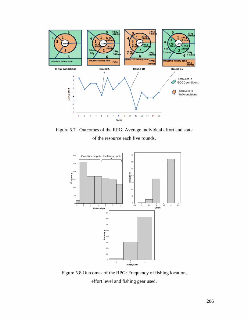
206
Figure 5.7 Outcomes of the RPG: Average individual effort and state
of the resource each five rounds.
Figure 5.8 Outcomes of the RPG: Frequency of fishing location,
effort level and fishing gear used.
Land
1
2
3
5
6
4
Industrial fishery zone
22 Kg6 times
20 Kg4 times
24Kg3 times
16 Kg4 times
22 Kg6 times
8 Kg2 times
75Kg
Round 5
Land
1
2
3
5
6
4
Industrial fishery zone
26 Kg7 times
32 Kg4 times
20Kg3 times
0 Kg0 times
12 Kg3 times
48 Kg7 times
59Kg5 times
Land
1
2
3
5
6
4
Industrial fishery zone
19 Kg9 times
20 Kg4 times
16Kg4 times
16 Kg2 times
0 Kg0times
4 Kg
3 times
21Kg3 times
Round 10 Round 15
Land
1
2
3
5
6
4
Industrial fishery zone
Initial conditions
Resource in GOOD conditions
Resource in BAD conditions
0 1 2 3 4 5 6
FisherySpot
0
5
10
15
20
25
30
Fre
qu
en
cy
Mean = 3,07Std. Dev. = 1,761N = 105
Histogram
0 1 2
FisheryGear
0
10
20
30
40
50
60
70
80
Fre
qu
en
cy
Mean = 1,68Std. Dev. = 0,509N = 105
Histogram-0,5 0 0,5 1 1,5 2 2,5
Effort
0
10
20
30
40
50
60
70
Fre
qu
en
cy
Mean = 1,58Std. Dev. = 0,549N = 105
Histogram
Far fishery spotsClose fishery spots
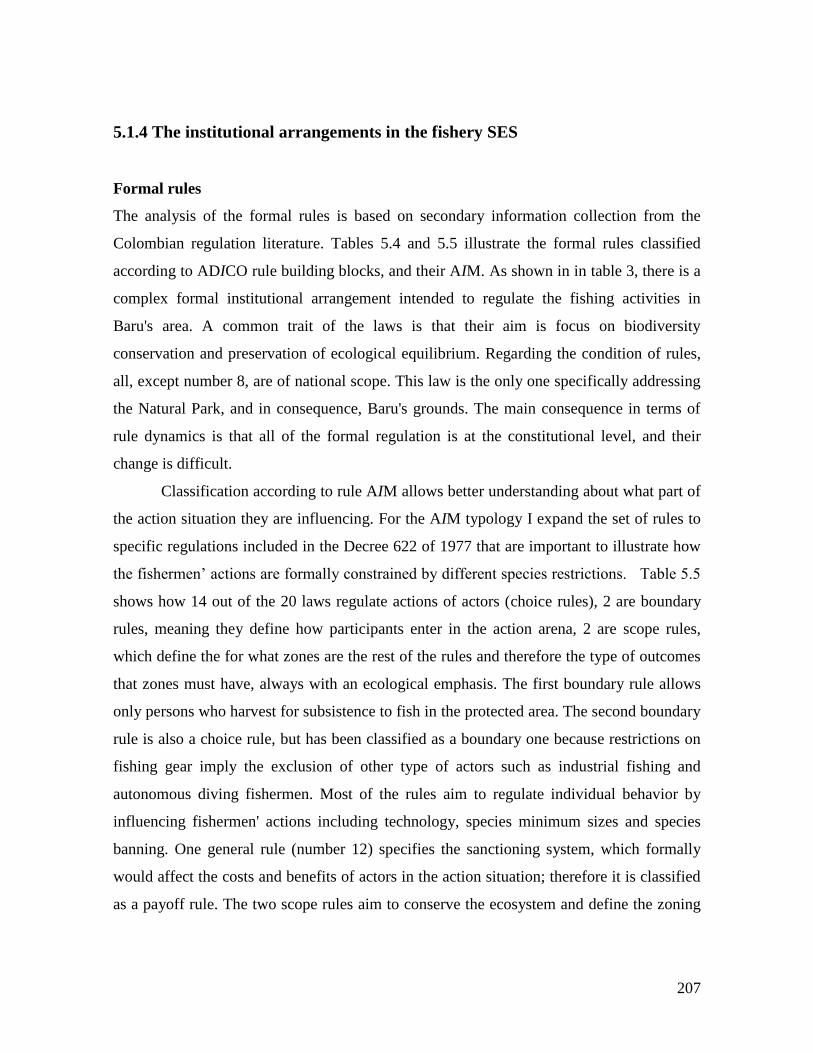
207
5.1.4 The institutional arrangements in the fishery SES
Formal rules
The analysis of the formal rules is based on secondary information collection from the
Colombian regulation literature. Tables 5.4 and 5.5 illustrate the formal rules classified
according to ADICO rule building blocks, and their AIM. As shown in in table 3, there is a
complex formal institutional arrangement intended to regulate the fishing activities in
Baru's area. A common trait of the laws is that their aim is focus on biodiversity
conservation and preservation of ecological equilibrium. Regarding the condition of rules,
all, except number 8, are of national scope. This law is the only one specifically addressing
the Natural Park, and in consequence, Baru's grounds. The main consequence in terms of
rule dynamics is that all of the formal regulation is at the constitutional level, and their
change is difficult.
Classification according to rule AIM allows better understanding about what part of
the action situation they are influencing. For the AIM typology I expand the set of rules to
specific regulations included in the Decree 622 of 1977 that are important to illustrate how
the fishermen’ actions are formally constrained by different species restrictions. Table 5.5
shows how 14 out of the 20 laws regulate actions of actors (choice rules), 2 are boundary
rules, meaning they define how participants enter in the action arena, 2 are scope rules,
which define the for what zones are the rest of the rules and therefore the type of outcomes
that zones must have, always with an ecological emphasis. The first boundary rule allows
only persons who harvest for subsistence to fish in the protected area. The second boundary
rule is also a choice rule, but has been classified as a boundary one because restrictions on
fishing gear imply the exclusion of other type of actors such as industrial fishing and
autonomous diving fishermen. Most of the rules aim to regulate individual behavior by
influencing fishermen' actions including technology, species minimum sizes and species
banning. One general rule (number 12) specifies the sanctioning system, which formally
would affect the costs and benefits of actors in the action situation; therefore it is classified
as a payoff rule. The two scope rules aim to conserve the ecosystem and define the zoning

208
inside the Park. These two rules immediately place Baru fishing zones under the effect of
the rest.
209
Table 5.4 Formal statements ADICO syntax components
STATEMENT ATTRIBUTE DEONTIC AIM CONDITION OR ELSE TYPE
1. Creation of the Natural Park
Corales
del Rosario y San Bernardo (Law
2811/74)
Colombian and
alien citizens
Definition of
permitted and
prohibited
actions
Conservation
of biodiversity
and
maintaining of
ecological
equilibrium
All National
Natural Park
areas
Rule
2. Marine geographical zoning
definition for National Natural
Parks System.
(Decree 622/1977)
Colombian and
alien citizens
Generic
prohibited and
allowed
activities in
each zone
Definition
of use zones
All National
Natural Park
areas
Specifies
Specify
sanctions for
the previous
rule
Rule
3. Every activity that the
competent environmental authority
considers to cause significant
modifications of the environment
or the natural values of the
different zones of the National
Natural Parks System is prohibited
(Decree 622/1977).
Colombian and
alien citizens
Prohibition of
every activity
considered to harm
the Natural Parks
by authorities
To conserve
the ecological
equilibrium
All National
Natural Park areas
The violation
of any rule
implies a
fine, that
ranges
between
USD $50 and
USD$ 250,
or the fine is
defined by
the local
environmenta
l authority
according the
economic
capacity of
the violator.
(Decree
622/1977)
Rule
4. It is prohibited to exercise any
fishing action, except fishing with
scientific purposes authorized by
the environmental authority,
sportive fishing and, subsistence
fishing. These allowed activities
must not threaten the ecological
stability of the Park (Decree
622/1977).
Colombian and
alien citizens
Prohibition of
industrial and
artisanal fishing,
and allowing
sportive, scientific
and subsistence
fishing
To conserve
the ecological
stability
All National
Natural Park areas
Rule
5. It is forbidden to extract
resources in banned or from
reserved areas. (Fisheries General
Law 13 /1990)
Colombian and
alien citizens
Prohibition of any
fishing in banned
and reserved areas
To assure the
sustainable
development of
the fishery
resource
All the Colombian
territory Offenders to
this law (Law
13/90) and
other norms
on the same
topic will be
punished,
according the
gravity of the
offence, with
the following
sanctions: 1)
Written
advertence,
2) Fine, 3)
Confiscation
Rule
6. Aquatic species declared
threatened and in danger of
extinction will be protected by the
government. The competent
governmental agency will
implement the necessary measures
in order to avoid extinction
according international treaties
(Fisheries General Law 13 /1990)
Colombian and
alien citizens
Prohibited to
harvest endangered
species
Endangered
aquatic species
protection
Colombian
territory
Rule
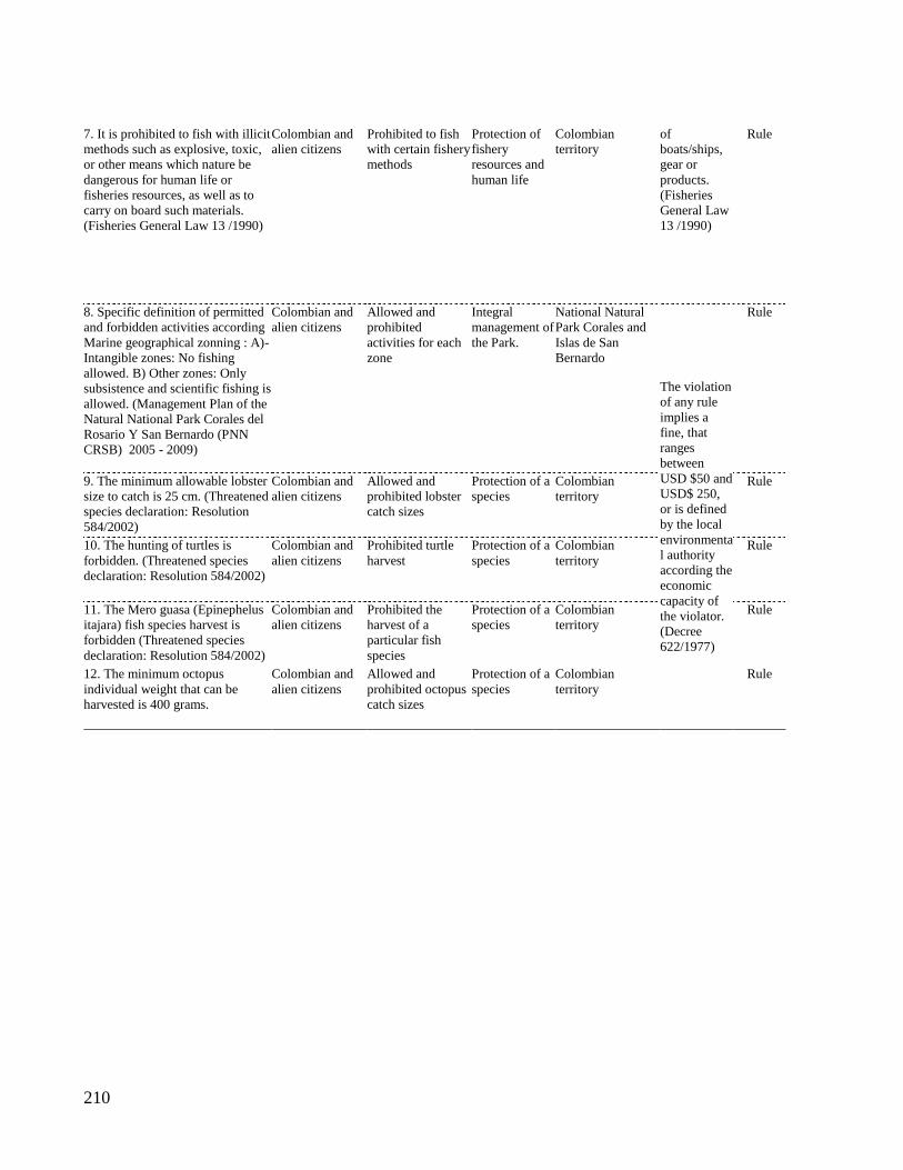
210
7. It is prohibited to fish with illicit
methods such as explosive, toxic,
or other means which nature be
dangerous for human life or
fisheries resources, as well as to
carry on board such materials.
(Fisheries General Law 13 /1990)
Colombian and
alien citizens
Prohibited to fish
with certain fishery
methods
Protection of
fishery
resources and
human life
Colombian
territory
of
boats/ships,
gear or
products.
(Fisheries
General Law
13 /1990)
Rule
8. Specific definition of permitted
and forbidden activities according
Marine geographical zonning : A)-
Intangible zones: No fishing
allowed. B) Other zones: Only
subsistence and scientific fishing is
allowed. (Management Plan of the
Natural National Park Corales del
Rosario Y San Bernardo (PNN
CRSB) 2005 - 2009)
Colombian and
alien citizens
Allowed and
prohibited
activities for each
zone
Integral
management of
the Park.
National Natural
Park Corales and
Islas de San
Bernardo
The violation
of any rule
implies a
fine, that
ranges
between
USD $50 and
USD$ 250,
or is defined
by the local
environmenta
l authority
according the
economic
capacity of
the violator.
(Decree
622/1977)
Rule
9. The minimum allowable lobster
size to catch is 25 cm. (Threatened
species declaration: Resolution
584/2002)
Colombian and
alien citizens
Allowed and
prohibited lobster
catch sizes
Protection of a
species
Colombian
territory
Rule
10. The hunting of turtles is
forbidden. (Threatened species
declaration: Resolution 584/2002)
Colombian and
alien citizens
Prohibited turtle
harvest
Protection of a
species
Colombian
territory
Rule
11. The Mero guasa (Epinephelus
itajara) fish species harvest is
forbidden (Threatened species
declaration: Resolution 584/2002)
Colombian and
alien citizens
Prohibited the
harvest of a
particular fish
species
Protection of a
species
Colombian
territory
Rule
12. The minimum octopus
individual weight that can be
harvested is 400 grams.
Colombian and
alien citizens
Allowed and
prohibited octopus
catch sizes
Protection of a
species
Colombian
territory
Rule
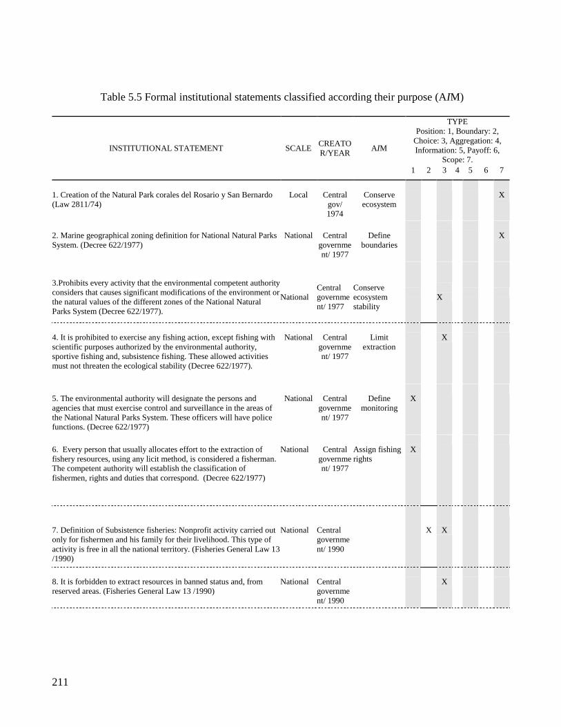
211
Table 5.5 Formal institutional statements classified according their purpose (AIM)
INSTITUTIONAL STATEMENT SCALE CREATO
R/YEAR AIM
TYPE
Position: 1, Boundary: 2,
Choice: 3, Aggregation: 4,
Information: 5, Payoff: 6,
Scope: 7.
1 2 3 4 5 6 7
1. Creation of the Natural Park corales del Rosario y San Bernardo
(Law 2811/74)
Local
Central
gov/
1974
Conserve
ecosystem
X
2. Marine geographical zoning definition for National Natural Parks
System. (Decree 622/1977)
National
Central
governme
nt/ 1977
Define
boundaries
X
3.Prohibits every activity that the environmental competent authority
considers that causes significant modifications of the environment or
the natural values of the different zones of the National Natural
Parks System (Decree 622/1977).
National
Central
governme
nt/ 1977
Conserve
ecosystem
stability
X
4. It is prohibited to exercise any fishing action, except fishing with
scientific purposes authorized by the environmental authority,
sportive fishing and, subsistence fishing. These allowed activities
must not threaten the ecological stability (Decree 622/1977).
National
Central
governme
nt/ 1977
Limit
extraction
X
5. The environmental authority will designate the persons and
agencies that must exercise control and surveillance in the areas of
the National Natural Parks System. These officers will have police
functions. (Decree 622/1977)
National
Central
governme
nt/ 1977
Define
monitoring
X
6. Every person that usually allocates effort to the extraction of
fishery resources, using any licit method, is considered a fisherman.
The competent authority will establish the classification of
fishermen, rights and duties that correspond. (Decree 622/1977)
National
Central
governme
nt/ 1977
Assign fishing
rights
X
7. Definition of Subsistence fisheries: Nonprofit activity carried out
only for fishermen and his family for their livelihood. This type of
activity is free in all the national territory. (Fisheries General Law 13
/1990)
National
Central
governme
nt/ 1990
X
X
8. It is forbidden to extract resources in banned status and, from
reserved areas. (Fisheries General Law 13 /1990)
National
Central
governme
nt/ 1990
X
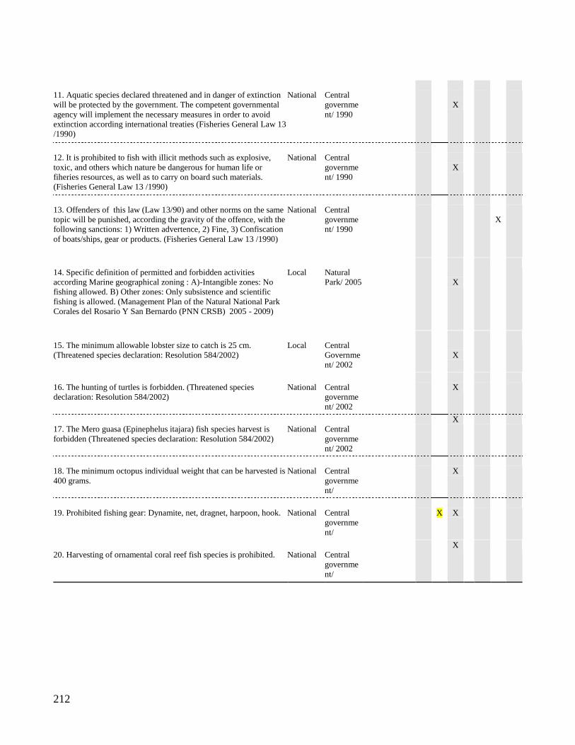
212
11. Aquatic species declared threatened and in danger of extinction
will be protected by the government. The competent governmental
agency will implement the necessary measures in order to avoid
extinction according international treaties (Fisheries General Law 13
/1990)
National
Central
governme
nt/ 1990
X
12. It is prohibited to fish with illicit methods such as explosive,
toxic, and others which nature be dangerous for human life or
fiheries resources, as well as to carry on board such materials.
(Fisheries General Law 13 /1990)
National
Central
governme
nt/ 1990
X
13. Offenders of this law (Law 13/90) and other norms on the same
topic will be punished, according the gravity of the offence, with the
following sanctions: 1) Written advertence, 2) Fine, 3) Confiscation
of boats/ships, gear or products. (Fisheries General Law 13 /1990)
National
Central
governme
nt/ 1990
X
14. Specific definition of permitted and forbidden activities
according Marine geographical zoning : A)-Intangible zones: No
fishing allowed. B) Other zones: Only subsistence and scientific
fishing is allowed. (Management Plan of the Natural National Park
Corales del Rosario Y San Bernardo (PNN CRSB) 2005 - 2009)
Local
Natural
Park/ 2005
X
15. The minimum allowable lobster size to catch is 25 cm.
(Threatened species declaration: Resolution 584/2002)
Local
Central
Governme
nt/ 2002
X
16. The hunting of turtles is forbidden. (Threatened species
declaration: Resolution 584/2002)
National
Central
governme
nt/ 2002
X
17. The Mero guasa (Epinephelus itajara) fish species harvest is
forbidden (Threatened species declaration: Resolution 584/2002)
National
Central
governme
nt/ 2002
X
18. The minimum octopus individual weight that can be harvested is
400 grams.
National
Central
governme
nt/
X
19. Prohibited fishing gear: Dynamite, net, dragnet, harpoon, hook.
National
Central
governme
nt/
X
X
20. Harvesting of ornamental coral reef fish species is prohibited.
National
Central
governme
nt/
X
213
Rules in use
In order to understand the operative rules in the system, I describe what interviewees
express about formal rules and actual behavior in local fisheries. Regulations on minimum
extraction sizes of certain species, banning of endangered or high ecosystem importance
species, fishing gear restrictions and zone banning are the rules mentioned by fishermen
and park representatives.
The lobster (Panulirus argus)
Lobster catch size restriction started to be implemented in 2002. The minimum size
for harvesting is 21 cm in length. This was achieved through the very close work of the
Park officers with fishermen and touristic operators that buy lobster. The role played by the
fisher's association (Pesbaru) was important because the association adopted the formal
rule. The monitoring of the rule was carried out by Park workers and fishermen. Fishermen
interviewed agree that, at that time, there were good relations with Park authorities and it
was possible to make agreements. Nowadays the rule seems not to be enforced due to "lack
of information" as expressed in one of the interviews; now Park authorities are trying to
organize fishermen to collect data on captures. One of the Park functionaries explained that,
at that time, the sanction was the seizing of the product. Park functionaries used to plan
monitoring trips specifically for lobster monitoring. They used to make the trips around 9
am where almost all the fishermen were harvesting. Pesbaru used to carry out their own
monitoring, but as a consequence the organization paid a toll; at the beginning the
fishermen association had 38 members, but due to the adoption of the lobster rule 13
members quit Pesbaru. Most of the fishermen express that the rule does not benefit the
community because the resource is currently in bad condition and they have to work. When
a fisherman sees another one harvesting lobsters under the permitted size they do not speak,
otherwise their own reputation will be harmed and they will be known as an informer.
214
The queen conch (Eustrombus gigas), mero guaso (Epinephelus itajara) and marine turtle
(several species)
This conch species is in danger of extinction and its harvesting is completely
prohibited. The interviewed Park representative explained that when they catch a fisher
with conchs in the boat they put the small ones in the sea again, but not the bigger ones.
There is an NGO in the zone that buys the adult conch from the fishermen in order to return
them to the sea. The Park employee acknowledged/observed that they never have done a
monitoring trip explicitly for conch monitoring. This species is one of the most valued by
the local community, they catch them, not for selling but for their own consumption.
Though the local community knows the banning rule for this species "they take all they
can" (Interview with a local fisher). When a fisherman sees fisher see a peer catching
conch, it is not a big deal, they just chat about it. Clearly, this rule does not reflect the
preferences of the community, and it is not perceived as a rule that benefits the community.
The same situation was reported for mero (Epinephelus itajara) and marine turtles.
Reef or ornamental fishes
The fishing of these species is formally forbidden. Interviewees agree that the
existence of these species in the reefs attracts tourists. But people acknowledge that they
fish these species for household consumption and selling them to the some local hotels.
One of the Park representatives interviewed expressed that this rule does not reflect the
preferences of the community. Fishermen from neighboring villages usually fish these
species, and the common behavior of Baru fishermen is to denounce them.
Fishing gear
The use of dynamite and gunpowder for fishing is formally prohibited since 1990
(Fisheries General Law 13/1990). All of the interviewed fishermen agree that this fishing
practice has diminished through time and that very few of Barú fishermen currently do that.
Fishing gear such as harpoons and all types of fishing nets are prohibited. Sanctions for
dynamite use include imprisonment and for nets use is the confiscation of equipment.
215
Interviewees agree that fishermen do not denounce the use of prohibited gear; they only
denounce the prohibited gear when fishermen from other villages use them. The dynamite
use is generally denounced by people who are working on the land and hear the explosions.
The only gear allowed in the entire Park zone are nylon fishing lines, except in the core
conservation zone, which is a permanent banned area that allows no fishing. Interviewed
fishermen gave ambiguous answers to the question about the compliance of these rules.
Rule compliance
Though interviewed fishermen are well informed about formal rules, their
compliance level seems to be low. For example, prohibited species such as sea turtles and
conch are harvested and the reason given is that they belong to their cultural preferences,
therefore, mostly with conch, when they spot them they just catch them. The case of marine
turtle species is less common but in general they speak openly about it. Regarding
minimum sizes of other species such as octopus and lobster the common position is that
they try to fulfill the rule but in the face of present scarcity they have to catch it. Park
authorities recognize that their monitoring capacity is extremely low, and that current
relations with Pesbaru and the community are not in good shape. Nowadays the popularity
of Park authorities among the local community is low and there is no clear strategy for
working with the community. In general fishermen express directly that there is a low level
of rule compliance. One of the questions asked was: From each ten fishermen, how many
follow the rules? For example the answer by one person who specialized in lobster and
octopus catching: "I think very few, that's why I'm telling you we are in a very critical
situation regarding the resource, it is totally depleted, but we have harvest because there
isn't another way of living" (Interview, Baru, July 23, 2007). There is a general consensus
among interviewed fishermen on this point.
Fishing gear rules seem to show a higher compliance level. Dynamite and powder
gun use is clearly seen as bad practice. Nets and harpoon are less used, and local fishermen
particularly blame other villages for the use of net gear.
Rule enforcement is characterized by all the interviewees as a very unequal
situation. This feeling is clearly expressed by one of the fishermen: "The wider side for
him, the narrower side for me", meaning that the rules apply for small fishermen without
216
money and power, but not for others such as sportive fishermen, wealthy persons and
industrial fishery.
The purpose of the rules
Looking at the AIM classification of the rules in use it is possible to describe the
current situation.
Position rules: I include this type of rule as a rule in use because the actual status of
one of the positions is different to the formal one, and it determines the possible actions
linked to it. Fishermen from Barú are artisanal fishermen and not only self-consumption
fishermen, this clarification is important because according the formal institution (Table 4)
the only fishing allowed in the area for locals is subsistence fishing, which is defined as a
nonprofit activity only for individual or household consumption, and it is allowed in all the
Colombian territory. But what Barú fishermen practice includes what the law calls artisanal
fishery. This type of fishing includes individual or collective fishing in cooperatives or
associations, with personal work, and personal fishing gear constituting a small scale
productive activity (Fisheries General Law 13/1990). This is illustrated by one of the
fishermen: "they say that here we do subsistence fishing, well, for example, I have to feed
four kids, my wife, I pay electricity, gas… and how am I going to live from subsistence
fishing? Simply to catch what I'm going to eat, and so what with the other stuff? (Interview
with a fisher 2008). This is the general situation of locals. Therefore, members are artisanal
fishermen from Barú, Park authorities, touristic operators and a NGO (Ceiner).
Boundary rules. The issue that these types of rules are addressing in this SES is
fundamental to understanding the system dynamics. Boundary rules or entry and exit rules
are defined by three points: "(1) who is eligible to enter a position, (2) the process that
determines which eligible participants may enter (or must enter) positions, and (3) how an
individual may leave (or must leave) a position." (Ostrom 2005: 194). Formally speaking
any person is allowed to practice subsistence and sportive fishing in the Park areas,
according to rule 4 (Table 4). Local marine territorial sense plays a key role in the
definition of first-order boundary rules in use, which define the eligibility to occupy a
position. Being Afro-Colombian traditionally settled in the area is a characteristic that
entitles any local to use the fishing grounds. This is clearly expressed by Baru fishermen as
217
already discussed above in the board game definition. The following extract from one of
the interviews illustrates this point:
Interviewer: "Who has rights on the fishing grounds?"
Fisher: "We, the natives"
I: "What kind of rights?"
F: "like fishing in them"
I: "Have you ever felt that you are doing something illegal while fishing in these
places?"
F:" No, never. I would ban other places different from ours."
(Interview with a fisherman, 2008)
Being part of ancestral Afro-Colombians communities is the first condition for
accessing to the fishery commons. Surrounding villages also have this condition; therefore,
a second-order entry rule is in use, which establishes a subset of position-holders based on
belonging to the Barú community territory, including the Rosario Islands. The islands and
the adjacent marine areas are traditionally conceived as the rural zones of Baru. This entry-
exit rule for using the commons fishing grounds is evidenced in the role game design
process, several interviews and field observations.
Choice rules. This type of rules "specify what a particular occupying position must,
must not, or may do at a particular point in a decision process in light of conditions that
have, or have not, been met at that point in the process." (Ostrom 2005: 200). Extracting
decisions of fishermen are constrained by choice rules, therefore the above discussed rules
for harvesting certain species and the use of determined fishing equipment fall in this
category. Table 4 illustrates the formal choice rules that aim to prescribe the actions of
participants in Baru's action situation. Though the understanding of choice rules in use is a
challenging task, it is possible to explain what could have been happening. The park
management style at the beginning of 2000 was trying to work together with local
fishermen communities, and they managed to build close relations and encouraging
fishermen association development. One of the main results was that the fisher's
organization Pesbaru adopted formal choice rules for their practices as it is confirmed by
fishermen in interviews. The fisher's organization and the Park administration were moving
together into a consensus for institutional arrangements that even included self monitoring
among Pesbaru members. Pesbaru also managed to raise funds for an experimental project
placing fish aggregation devices in and outside of the Park (Interview with Pesbaru leader,
218
2008). Though members of the organization are 25 out of 200 fishermen in the community,
the association was gaining momentum and sound fishing practices were spreading among
other local fishermen. In 2004 the Park's director changed, as well as the management style.
The new administration abandoned the close work with the community, and the emphasis
was on enforcing formal choice rules. This process negatively affected the levels of trust
that the Park and fishermen built. In order to enforce the formal choice rules it was
necessary to contradict a fundamental boundary rule in use: local fishermen are not holders
of an ancestral right to the marine territory. In this process the formal rule about subsistence
fishing began to be brought up signaling that daily fishermen' behavior was illegal. One of
the consequences of this enforcement affected the fish aggregation device experiment.
Formal choice rules do not allow these types of activities inside the park. Internal
organizational conflicts led to divisions among Pesbaru fishermen (2007-2008).
Interviewed fishermen recognized the existence of choice formal rules, the benefits of some
of them, but expressed the lack of monitoring, and the lack of compliance was implicitly
suggested. The inequalities in rule enforcement and sanctioning are permanently expressed
in interviews and role game. The general understanding is that authorities apply rules
unequally depending on the type of actor; industrial fishery boats and wealthy sportive
fishermen have different treatment compared to Baru fishermen. In this respect, choice
rules in use distribute the power of actions in a high unequal manner. Choice rules in use
widen the range of actions for some actors and narrow them for Baru fishermen, in this way
they are affecting the basic rights, duties, liberties of actors and their relative distribution.
Information and payoff rules. Interviewees agree that when a fisher catches a
person breaking a formal choice rule he does not denounce this person, otherwise his own
reputation is seriously damaged. Since information rules
"…authorize channels of information flow among participants, assign the
obligation, permission, or prohibition to communicate to participants at particular
decision nodes… Information rules are particularly important in generating
information about past actions of participants so that other participants can know
who is, or is not, trustworthy" (Ostrom 2005: 206).
This type of behavior is a social norm, which works, first as an information rule in use, and
secondly as a payoff rule in use. The social norm directly affects the costs and benefits of
actions of participants in the sense that sanctions are not applied.
219
Payoff rules in use are concentrated in the sanction system. Before the internal
problems, the fishermen' association implemented graduated sanctions. Some interviewees
said that first the rule breaker was warned verbally, then the second time there was a low
monetary fine, and if the person breaks the rule again a higher fine is applied. At the same
time they accept that the organization was not capable of monitoring fishermen, mainly
when they sold their product to middle men and hotels before landing in the village. It is
important to note that none scope and aggregation rules were not identified as rules in use.
In table 5.6 I synthesize the rules in use in Baru's fishery system. Although the term
"rule" implies an institutional statement with a complete ADICO structure, in this case
prescriptions have the first four components; ADIC, therefore we are dealing with "norms",
they lack a clear OR ELSE component. These norms directly affect the components of the
action arena and shape its outcomes discussed in the next section. Table 5.6 also
displays/shows/gives the main source of observation for each rule; interviews (I) and role
game (RG).
Table 5.6 Rules in use.
RG: Observed in the Role game. I: Interviews
Position There are 5 positions: 1) Baru artisanal fishermen, 2) other villages' artisanal
fishermen, 3) industrial fishery boats, 4) touristic operators, and 5) environmental
Park officials.
RG, I
Boundary 1) All Afro Colombian inhabitants from Baru are permitted to fish in the zone or
else those fishermen from other villagers are suspects of using illegal fishing gear
and may be denounced.
2) Environmental authorities permit any participant who has more power and
money than local artisanal fishermen to fish in the zone.
I, RG
I
Choice 1) Baru fishermen are permitted to fish any species and any size if they need it.
2) Destructive fishing gear is not permitted
I
RG, I
Information 1) It is not permitted to denounce a fisher that is breaking a formal rule or else
one’s own reputation will be negative affected
I
Payoff rules 1) If breaking a formal rule, graduated verbal and monetary sanctions are applied
to artisanal fisheries. Rarely enforced.
I, RG
5.1.5 Outcomes of the SES’ action situation
So far I have discussed the fishing action situation using the RPG as a lens and intermediate
tool for simplifying the SES, starting with the simplistic representation of the experimental
setting. In this section I discuss the outcomes of the SES action situation focusing on
220
cooperation, trust and the level of conformance to general morality as the more relevant
results.
Cooperation and trust
The average behavior at the group level of the field experiments indicates lower
levels of cooperation than optimal in the two stages: with and without external rules, most
groups over-extracted the resource leading both sites A and B towards low stock levels.
Considering effort as an indicator of cooperation, there are no significant differences in
effort between the first and second stages of the experiment. As another indicator of
cooperation, we can also measure how frequently a fishing place is in a low or high state,
and we observe that the groups had difficulties in getting the fishing sites back to the high
state (Figure 7). Group earnings could not be sustained at high levels after the third round
both before and after the rules were applied. For the second stage higher earnings were
sustained for an extra round or two but such improvement did not last. The reason is that
the group efforts on both sites A and B were sufficiently high to bring both sites to the low
level of stocks as with the consequent lower payoffs, and recovering back from low to high
stocks of fisheries was very difficult. Surveys carried out after the field experiments show
an interesting perception about the community of the participants: 61% of respondents
answered that people would be very likely to cooperate if there were a problem related to
natural resources, and 30% responded that people would be somewhat likely to cooperate.
When it comes to the RPG, the players introduced the role of the National Park and
the settings of the game gave an important role to the Park. There were no direct
interactions among the fishermen to manage the resource. The cooperation goes through the
authority of the National Park. In the RPG session cooperation exhibits an increasing trend
when environmental authorities hear their concerns and discuss about collaboration
between fishermen and the Natural Park. A second factor leading to an increase in
cooperation was the existence of alternative income generating options.
Three three remarkable points from interviews carried with local fishermen. 1)
Local leaders and authorities are an obstacle instead of support for cooperation. 2)
Interviewees, outside the arena of experiments and RPG, express that there is short and
long term cooperation. Short term cooperation is focused on a household’s daily needs, and
221
it destroys long term cooperation, which is identified as collective actions for the
conservation of the resources. 3) Long term cooperation would be affected by coordination
difficulties and free riding behavior.
The information obtained through the surveys, interviews and during the RPG shed
some light on cooperation during the experiments. The context pushes the players towards
individualistic behavior. Baru's fishermen consider the governance of the fishery to be in
the hands of local leaders or a governmental body, which are considered to be obstacles. If
we link this context to the field experiment action arena we can understand the
uncooperative behavior. In this simplified arena participants are in an individual short-term
situation where incentives for cooperation are not straightforward, and they need high
levels of coordination without communication. The short-term monetary incentives are
perceived as a mean to fulfill daily needs, and in the absence of communication,
coordination is hard to achieve.
Rules and general morality conformance
I identified four types of normative beliefs inferred from the interviews and role
game construction and discussions, which constitute the first level of morality conformance
discussed in the conceptual framework. To fish in order to feed the household is acceptable,
no matter what the state of the resource is. Household needs are an imperative that justifies
any behavior that does not fulfill formal rules about size fish restrictions. This normative
belief does not seem to extend to the use of illegal fishing gear, which is constantly
mentioned but not accepted morally. The second widespread normative belief is that
denouncing a fisher when breaking a formal rule is not accepted. Interviewees concur
without a doubt that this type of behavior is socially punished by the community through a
stigmatization of such person as a stoolie. The third normative belief is that bribing
authorities regarding natural resources is not acceptable from the point of view of Baru
fishermen.
Main findings regarding generalized beliefs can be synthesized as follows: To bribe
authorities is easy for players with power. Bribing authorities is necessary to avoid formal
punishment. If formal authorities do not consult with local fishermen about the design of
Park rules, these rules are not legitimate. Enforcement of formal rules is applied according
222
to the socioeconomic status of each actor; this is, the law is not for all, artisanal fishermen
have to follow the rules but industrial fishing boats, rich and non-local people have
different treatment.
Second level of morality conformance. The normative beliefs can be classified in
terms of morally, culturally and legally valid behaviors. As morally valid behavior I
include: To fish in order to feed the household is acceptable, no matter what is the state of
the resource. Since formal authorities do not take into account local fishermen for rule
design, then non-compliance with rules is accepted. Bribing authorities is not accepted. To
keep one portion of the fishing product to give it to their neighbors that could not work or
to poorer families is a moral norm. In terms of culturally valid behavior, the non-
compliance with formal rules is accepted when there is no recognition of local community
in its design. As an example, harvesting species such as turtles and reef fishes for
household consumption is accepted.
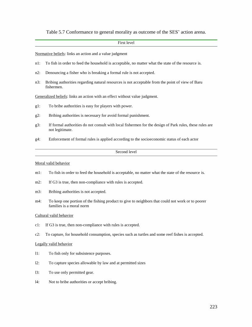
223
Table 5.7 Conformance to general morality as outcome of the SES’ action arena.
First level
Normative beliefs: links an action and a value judgment
n1: To fish in order to feed the household is acceptable, no matter what the state of the resource is.
n2: Denouncing a fisher who is breaking a formal rule is not accepted.
n3: Bribing authorities regarding natural resources is not acceptable from the point of view of Baru
fishermen.
Generalized beliefs: links an action with an effect without value judgment.
g1: To bribe authorities is easy for players with power.
g2: Bribing authorities is necessary for avoid formal punishment.
g3: If formal authorities do not consult with local fishermen for the design of Park rules, these rules are
not legitimate.
g4: Enforcement of formal rules is applied according to the socioeconomic status of each actor
Second level
Moral valid behavior
m1: To fish in order to feed the household is acceptable, no matter what the state of the resource is.
m2: If G3 is true, then non-compliance with rules is accepted.
m3: Bribing authorities is not accepted.
m4: To keep one portion of the fishing product to give to neighbors that could not work or to poorer
families is a moral norm
Cultural valid behavior
c1: If G3 is true, then non-compliance with rules is accepted.
c2: To capture, for household consumption, species such as turtles and some reef fishes is accepted.
Legally valid behavior
l1: To fish only for subsistence purposes.
l2: To capture species allowable by law and at permitted sizes
l3: To use only permitted gear.
l4: Not to bribe authorities or accept bribing.
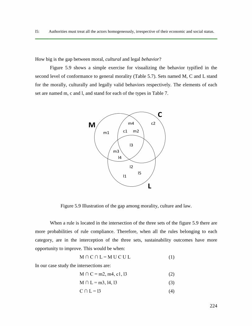
224
l5: Authorities must treat all the actors homogeneously, irrespective of their economic and social status.
How big is the gap between moral, cultural and legal behavior?
Figure 5.9 shows a simple exercise for visualizing the behavior typified in the
second level of conformance to general morality (Table 5.7). Sets named M, C and L stand
for the morally, culturally and legally valid behaviors respectively. The elements of each
set are named m, c and l, and stand for each of the types in Table 7.
Figure 5.9 Illustration of the gap among morality, culture and law.
When a rule is located in the intersection of the three sets of the figure 5.9 there are
more probabilities of rule compliance. Therefore, when all the rules belonging to each
category, are in the interception of the three sets, sustainability outcomes have more
opportunity to improve. This would be when:
M ∩ C ∩ L = M U C U L (1)
In our case study the intersections are:
M ∩ C = m2, m4, c1, l3 (2)
M ∩ L = m3, l4, l3 (3)
C ∩ L = l3 (4)
m1
l3
m3
l1
l2
l5
l4
c1
m4
m2
c2
C
M
L
225
and,
M ∩ C ∩ L = l3 (5)
the result of (5) is an indication of the gap among the three categories we are dealing with.
From this perspective one could say that the management system cannot be effective if it is
based on the already existent formal institutions, but in another kind of management
agreement capable of conciliating law, morality and culture. These three dimensions shape
human behavior in the action arena. Behavior of actors is linked to the beliefs and
behavioral types illustrated in the Table 5.7. A relevant question when studying behavior
from this perspective is about the reasons of participants to break the rules. The Table 5.8
illustrates a set of actors’ motivations for rule breaking related with the elements discussed
above (Table 5.7). Baru fishermen could be classified as rule breakers by conviction and
necessity depending if certain conditions are met, which are n1 and/or g3 (Table 5.7).
Fishermen from other villages could be rule breakers by necessity if n1 is met. Baru's
fishermen behave as cheating players when c2 condition is meet; in essence they know the
rules of the game, respect the game in a loose manner, and on occasions have moral
justifications, but they are aware that others have better moral claims. The same rationale
applies for: (1) industrial fisheries’ ship captains when entering to Park zones, (2) touristic
operators since they demand illegal fishing products for their businesses, (3) local leaders
when they "catch" a formal public position that can offer them economic stability. These
players usually make alliances with wealthy and political participants and contribute to the
unequal rule enforcement. Park officials seem to behave differently regarding rule
enforcement when facing participants different from Baru's fishermen, meaning wealthy
players and political power holders.
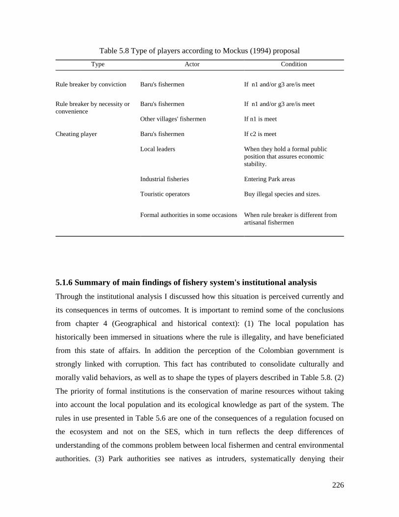
226
Table 5.8 Type of players according to Mockus (1994) proposal
Type Actor Condition
Rule breaker by conviction Baru's fishermen If n1 and/or g3 are/is meet
Rule breaker by necessity or
convenience
Baru's fishermen If n1 and/or g3 are/is meet
Other villages' fishermen
If n1 is meet
Cheating player Baru's fishermen If c2 is meet
Local leaders When they hold a formal public
position that assures economic
stability.
Industrial fisheries Entering Park areas
Touristic operators
Buy illegal species and sizes.
Formal authorities in some occasions When rule breaker is different from
artisanal fishermen
5.1.6 Summary of main findings of fishery system's institutional analysis
Through the institutional analysis I discussed how this situation is perceived currently and
its consequences in terms of outcomes. It is important to remind some of the conclusions
from chapter 4 (Geographical and historical context): (1) The local population has
historically been immersed in situations where the rule is illegality, and have beneficiated
from this state of affairs. In addition the perception of the Colombian government is
strongly linked with corruption. This fact has contributed to consolidate culturally and
morally valid behaviors, as well as to shape the types of players described in Table 5.8. (2)
The priority of formal institutions is the conservation of marine resources without taking
into account the local population and its ecological knowledge as part of the system. The
rules in use presented in Table 5.6 are one of the consequences of a regulation focused on
the ecosystem and not on the SES, which in turn reflects the deep differences of
understanding of the commons problem between local fishermen and central environmental
authorities. (3) Park authorities see natives as intruders, systematically denying their
227
population history. And, locals in turn, do not perceive the Park as a natural authority.
Table 5.7 shows how the consequence of the above three points is the generation of a
generalized belief (g3), that has produced a set of moral and valid behaviors, and a
typology of players (Table 5.8) with clear consequences for the outcomes of the action
situation.
In the experimental action arena most of participants chose the random access rule
for the second part of the experiment. I propose two hypotheses that I discuss next. The
random system is perceived as an easier way for rule braking. Assuming that the condition
of Table 5.8 is met; g1 and g3 in Table 5.7, the formal rule breaking is justified by the
convenience or necessity, and also they can be rule breakers by conviction (Table 5.8),
given the fact that the potential benefits of the experiments are changing their well being.
The random banning of fishery grounds and a low probability of inspection is analogous to
the way the formal institutions work. The big gap between morality, culture and law that
characterizes the system (formulation (5)), as well as the lack of legitimacy of formal rules,
transform the action arena in to a game in which the moral and cultural behaviors are valid.
As a consequence, rule enforcement and monitoring are only rare and external events that
fishermen must avoid.
Low levels of cooperation (defined as high levels of effort) exhibited in the
experiments and the first part of the role game are related with the fulfillment of daily
household needs, and are a consequence of the strong focus on formal rules in the
ecological system, instead of the SES. One of the key findings is that understanding of the
action arena by Baru's fishermen entails a difference in the conceptualization of the
commons dilemma, comparing with environmental authorities and the generalized aim of
the formal institutions. This fact is one of the dimensions of the cognitive conflict that starts
to emerge in this phase. It shapes the institutional problem, which drives most of the
outcomes of the action situation.
228
5.2 The Forestry System
5.2.1 Outcomes of the forestry experimental action situation
The theoretically predicted outcomes of the forestry experiment when players
extract the maximum possible in each round is that the stock collapses in round 5, and the
group accumulated tokens are 119. But if on the contrary all the players cooperate by
extracting fewer trees maximizing the collective benefits, the resource lasts 10 rounds and
the group earnings increase to 165 tokens (Cardenas et al. 2008). In the second part of the
experiment, rounds 11 to 20, participants vote one rule to be applied during these rounds.
The rules that participants can vote for are lottery (Rule 1), rotation (Rule 2), and property
rights (Rule 3). With the first rule, in each round two players are chosen randomly to
extract trees from the forest. In the second rule a fixed arrange is given for harvesting the
forest in which two players are allowed each round. With the third rule, each player can
harvest a maximum fixed amount of trees of 2 units. For all of the rules the inspection for
rule compliance is done throughout a dice, which is thrown by the facilitator at the end of
each round, and if it gives 6 all the players are inspected. If a player has broken the rule she
has to return the harvested units in addition to 3 tokens.
Figure 5.10a illustrates the resource’s behavioral pattern. The forest decreases
rapidly; in the first round the average extraction is of 20 units, close to the maximum
possible of 25 trees. However, in average, the forest does not finish in the ten rounds in
contrast with the theoretical prediction. When the rules are introduced the average number
of trees remained higher than in the first part, but far from the theoretical prediction in case
that all players would follow the rule. The average extraction (Figure 5.10b) shows a
decreasing behavior with a slight increase in round 4, and continues the decreasing until
one tree remains in the board in the round 10. In the second part the average individual
effort is considerably higher, starting, at round 11, in 3 trees, and remaining around this
number reaching its lower value in the round 20 close to 2 trees harvested. Individual
earnings, in average (Figure 5.10d), decrease at the same pace of the resource during the
first 10 rounds. In the second part the average individual earnings exhibit more variation
due to the effect of the fines when players break the rules and they are inspected.
229
In figure 5.11 it’s possible to observe the tendency of the average individual effort
in the rounds 11 to 20, for each session, which tends to maintain between 2 and 3 trees in
the sessions 2 and 10. In session 12 the variability is high while in session 6 the mean
remains slightly above 3 in rounds 11 to 19. This variability in contrast with the decreasing
trend in the first part is due to the inspection probability of rules. The players tend to keep
high extraction levels and when there is inspection they tend to decrease the effort in the
next round.
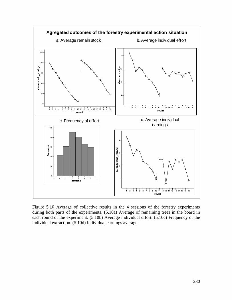
230
Figure 5.10 Average of collective results in the 4 sessions of the forestry experiments
during both parts of the experiments. (5.10a) Average of remaining trees in the board in
each round of the experiment. (5.10b) Average individual effort. (5.10c) Frequency of the
individual extraction. (5.10d) Individual earnings average.
b. Average individual effort
d. Average individual
earnings
a. Average remain stock
c. Frequency of effort
Agregated outcomes of the forestry experimental action situation
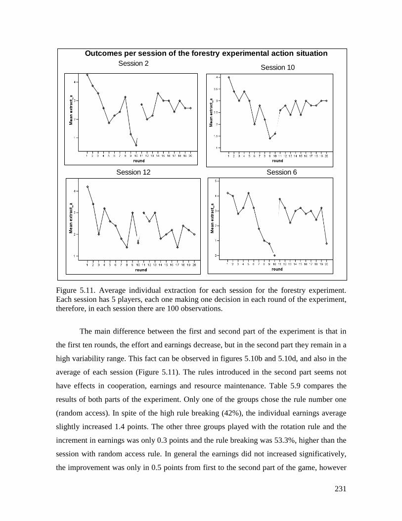
231
Figure 5.11. Average individual extraction for each session for the forestry experiment.
Each session has 5 players, each one making one decision in each round of the experiment,
therefore, in each session there are 100 observations.
The main difference between the first and second part of the experiment is that in
the first ten rounds, the effort and earnings decrease, but in the second part they remain in a
high variability range. This fact can be observed in figures 5.10b and 5.10d, and also in the
average of each session (Figure 5.11). The rules introduced in the second part seems not
have effects in cooperation, earnings and resource maintenance. Table 5.9 compares the
results of both parts of the experiment. Only one of the groups chose the rule number one
(random access). In spite of the high rule breaking (42%), the individual earnings average
slightly increased 1.4 points. The other three groups played with the rotation rule and the
increment in earnings was only 0.3 points and the rule breaking was 53.3%, higher than the
session with random access rule. In general the earnings did not increased significatively,
the improvement was only in 0.5 points from first to the second part of the game, however
Outcomes per session of the forestry experimental action situation
Session 2Session 10
Session 12 Session 6
232
the extraction patterns were different. Results show a positive relation between resource
growth decreasing and extraction level, this is, the faster the resource decreases, the more
trees are extracted in each round (Janssen et al. WP).
During the workshop of experimental results the participants proposed possible
solutions to the game. There were 6 different ideas about possible solutions to the game: (1)
To implement a seed nursery and to extract each one between 2 and 3 trees each round. (2)
To play with rule 3 (property rights rule: maximum 2 trees harvested each round per player)
“because in this way there is more chance to the forest to regenerate”. (3) To extract
between 3 and 4 trees each round per player and alternate with fisheries. (4) To cut just 1
tree per person each round but the government must compensate loggers for the wood they
do not harvest. (5) To combine timber harvest with other economic activities. (6) To extract
3 trees per person each round. Most of the proposals were around extraction of 2 and 3
trees, nobody proposed to extract 5 trees, neither 0 “because we need to eat” they said.
To test the proposals we did two demonstrations with the board and the magnetic
trees, harvesting 3 and 2 trees each round per person. As a conclusion, people agreed that
cutting always two trees allows to conserve the forest, “if we extract more we´ll get more
money but the forest ends faster” but the question was: is it possible to live extracting only
2 trees? Participants permanently tried to relate the game with their real situation, and one
of the participants expressed a general preoccupation: “it is possible that everybody in this
room harvests only 2 trees, but not everybody understands, people outside this room cut
everything at once”. In this moment the discussion was oriented towards the rules of forest
use, and one of the “Communitarian council” (ACAPA) pointed that “ we make our own
rules and one part of the people in the territory inform to the other part, we need to build a
communication network … the forest management plan must be articulated to the
municipal development plan”. Regarding the activities of the loggers she said: “people here
extract timber, fish and they do agriculture also”. At the end of the session one of the
participants said. “I think, this game needs a change in the rules because it is out of focus”,
this comment served as the necessary step linking the discussion about the experiments
with the improvement of forestry game and the co-construction of a role game of the forest.
Finally, the experimental forestry action arena analyzed here shows an inverse
relation between the level of trust of the community and rule compliance, but also the
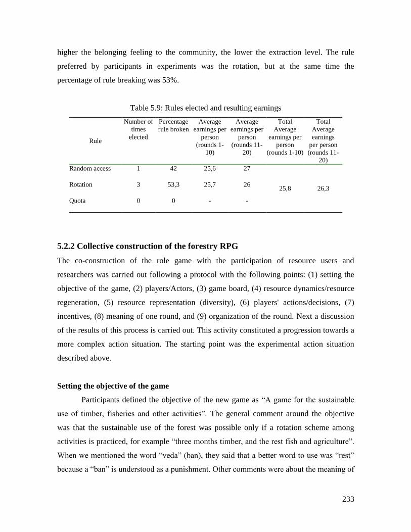
233
higher the belonging feeling to the community, the lower the extraction level. The rule
preferred by participants in experiments was the rotation, but at the same time the
percentage of rule breaking was 53%.
Table 5.9: Rules elected and resulting earnings
Rule
Number of
times
elected
Percentage
rule broken
Average
earnings per
person
(rounds 1-
10)
Average
earnings per
person
(rounds 11-
20)
Total
Average
earnings per
person
(rounds 1-10)
Total
Average
earnings
per person
(rounds 11-
20)
Random access
1 42 25,6 27
25,8 26,3 Rotation
3 53,3 25,7 26
Quota
0 0 - -
5.2.2 Collective construction of the forestry RPG
The co-construction of the role game with the participation of resource users and
researchers was carried out following a protocol with the following points: (1) setting the
objective of the game, (2) players/Actors, (3) game board, (4) resource dynamics/resource
regeneration, (5) resource representation (diversity), (6) players' actions/decisions, (7)
incentives, (8) meaning of one round, and (9) organization of the round. Next a discussion
of the results of this process is carried out. This activity constituted a progression towards a
more complex action situation. The starting point was the experimental action situation
described above.
Setting the objective of the game
Participants defined the objective of the new game as “A game for the sustainable
use of timber, fisheries and other activities”. The general comment around the objective
was that the sustainable use of the forest was possible only if a rotation scheme among
activities is practiced, for example “three months timber, and the rest fish and agriculture”.
When we mentioned the word “veda” (ban), they said that a better word to use was “rest”
because a “ban” is understood as a punishment. Other comments were about the meaning of
234
“sustainable use”, in the sense that the direct meaning of that was “to be careful with the
size of the trees we cut”.
The game board
The next step was the design of the game board. The question we posed to start
thinking in the game board was if the board used for the forestry experiment was suitable to
reach the objective set at the beginning of the workshop. The first general comment was
that the forest in ACAPA’s territory had to include small and big trees, different species as
well as resource regeneration. Next they started to put hands on the board reorganizing the
trees. They drew the small trees, “in regeneration”, the river, channels, paths to houses and
paths used to transport the wood (Figure 12). When they were discussing how to represent
places left by cut trees, they decided that the space should be a blank patch but it depends
on the form the tree was cut down; “if I sell this piece of land the new owner don’t have
any belonging sense, then he won’t take care on how this tree is falling down damaging
small trees in the sides” (RPG collective construction workshop. June, 2008), then the
discussion was about the difference of behavior between a person who uses a chain-saw
and the one who uses only manual saw. The first gain money only for cutting down the
tree, he does not care about the forest, but the second is different because he is generally the
owner of the land and he cares about his property. Participants express that many persons
take care of the forest and cut trees only of certain diameters and well distributed in the plot
in a way that after two or three years they have again their forest. Finally, they divided the
board for the game in 8 patches; 7 are plots for individual loggers and a public sector that
represents the mangroves sector and the coast. They stated that mangroves harvesting is not
allowed, but when a person needs wood to build a house he cuts some mangroves trees,
therefore they put 5 trees marked with an x representing the mangroves (Figure 12) difficult
to see
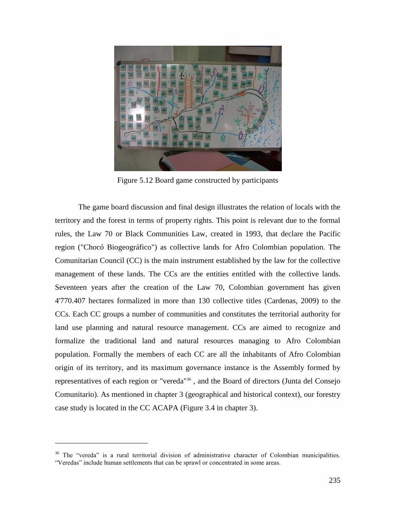
235
Figure 5.12 Board game constructed by participants
The game board discussion and final design illustrates the relation of locals with the
territory and the forest in terms of property rights. This point is relevant due to the formal
rules, the Law 70 or Black Communities Law, created in 1993, that declare the Pacific
region ("Chocó Biogeográfico") as collective lands for Afro Colombian population. The
Comunitarian Council (CC) is the main instrument established by the law for the collective
management of these lands. The CCs are the entities entitled with the collective lands.
Seventeen years after the creation of the Law 70, Colombian government has given
4'770.407 hectares formalized in more than 130 collective titles (Cardenas, 2009) to the
CCs. Each CC groups a number of communities and constitutes the territorial authority for
land use planning and natural resource management. CCs are aimed to recognize and
formalize the traditional land and natural resources managing to Afro Colombian
population. Formally the members of each CC are all the inhabitants of Afro Colombian
origin of its territory, and its maximum governance instance is the Assembly formed by
representatives of each region or "vereda"36 , and the Board of directors (Junta del Consejo
Comunitario). As mentioned in chapter 3 (geographical and historical context), our forestry
case study is located in the CC ACAPA (Figure 3.4 in chapter 3).
36 The “vereda” is a rural territorial division of administrative character of Colombian municipalities.
“Veredas” include human settlements that can be sprawl or concentrated in some areas.
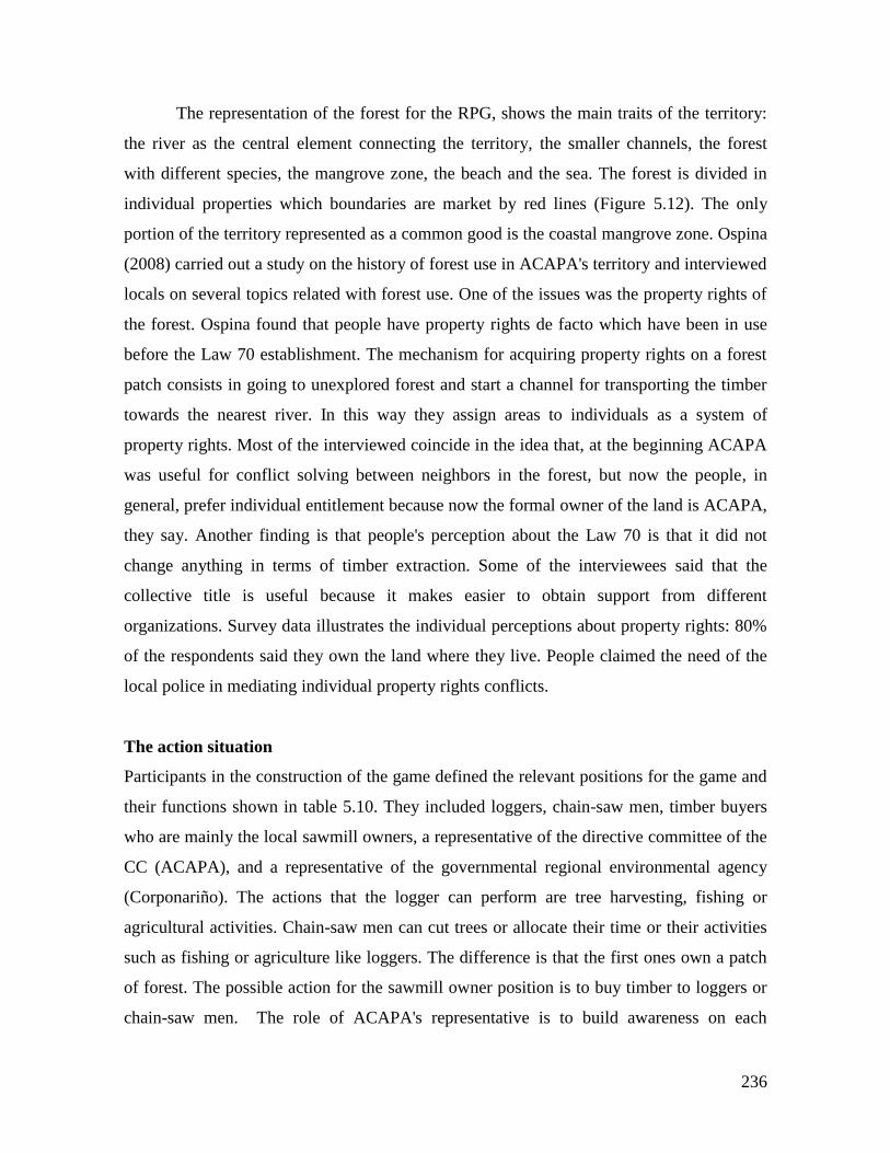
236
The representation of the forest for the RPG, shows the main traits of the territory:
the river as the central element connecting the territory, the smaller channels, the forest
with different species, the mangrove zone, the beach and the sea. The forest is divided in
individual properties which boundaries are market by red lines (Figure 5.12). The only
portion of the territory represented as a common good is the coastal mangrove zone. Ospina
(2008) carried out a study on the history of forest use in ACAPA's territory and interviewed
locals on several topics related with forest use. One of the issues was the property rights of
the forest. Ospina found that people have property rights de facto which have been in use
before the Law 70 establishment. The mechanism for acquiring property rights on a forest
patch consists in going to unexplored forest and start a channel for transporting the timber
towards the nearest river. In this way they assign areas to individuals as a system of
property rights. Most of the interviewed coincide in the idea that, at the beginning ACAPA
was useful for conflict solving between neighbors in the forest, but now the people, in
general, prefer individual entitlement because now the formal owner of the land is ACAPA,
they say. Another finding is that people's perception about the Law 70 is that it did not
change anything in terms of timber extraction. Some of the interviewees said that the
collective title is useful because it makes easier to obtain support from different
organizations. Survey data illustrates the individual perceptions about property rights: 80%
of the respondents said they own the land where they live. People claimed the need of the
local police in mediating individual property rights conflicts.
The action situation
Participants in the construction of the game defined the relevant positions for the game and
their functions shown in table 5.10. They included loggers, chain-saw men, timber buyers
who are mainly the local sawmill owners, a representative of the directive committee of the
CC (ACAPA), and a representative of the governmental regional environmental agency
(Corponariño). The actions that the logger can perform are tree harvesting, fishing or
agricultural activities. Chain-saw men can cut trees or allocate their time or their activities
such as fishing or agriculture like loggers. The difference is that the first ones own a patch
of forest. The possible action for the sawmill owner position is to buy timber to loggers or
chain-saw men. The role of ACAPA's representative is to build awareness on each
237
individual that the territory is a collective property in benefit of the community. The actions
of the environmental authority is to issue exploitation and mobilization licenses. The forest
harvesting licenses have a monetary cost, people has to pay in order to get the permit.
The logger (tuquero) position
This position represents all the inhabitants of ACAPA's territory that use the forest
as an important source of income through timber extraction. Population of ACAPA's
territory is about 12.000 persons living in an area of 95.000 hectares (Ospina 2008). We
could say that the level of heterogeneity is lower than the fishery system case discussed in
previous section regarding its economic activities. According to the survey 71% of the
participants in the experiments said that their main economic activity is to extract products
from the forest, 20% to fishing, and 5% to agriculture. As the rest of the Colombian Pacific
Coast, this population is among the poorest in the country, in contrast with the immense
biodiversity richness. In spite of the declining in timber market since the 1980s, still there is
a high percentage of the population that depends mainly on wood extraction; being the Sajo
(Campnosperma panamensis) the principal exploited species (Ospina 2008).
During the RPG construction the chain-saw men position was discussed and it was
concluded that they were people characterized by two factors: they do not own a part of the
forest and many of them come from other regions. Frequently they are hired by locals to
extract timber. Participants made emphasis that people who use this technology to harvest
trees do not take care where the tree falls and they cause big environmental negative
effects, also they cut any type of tree. They stated: “it is necessary to teach to the power
saw men and loggers to take care of the forest because they live from that”. They said that
they are focused in doing their work soon in order to increase their income. However,
Ospina (2008) found that the use of the chain saw has increased among the loggers or
"tuqueros" since the early 1980s, and that this has been the only technological change to
date. The mechanization not only has facilitated the tree cutting activity but also has
widening the commercialization of species by introducing the harder and more expensive
wood in the market. These species are found generally in the slopes of the hills and with the
traditional tools, axe and "machete" is complicated to bring them down to the river for
238
transporting. Therefore, with the chain saw it is possible to cut and make easier handling
the timber on site.
This situation contrasts with the characterization of loggers' position made by
participants and the emphasized differences with chain-saw men. I already mentioned that
during the RPG this difference was observed in the behavior of some players, which named
themselves explicitly as chain-saw men.
Buyers (sawmill owners) position
Participants included the sawmill position as the main buyer of timber, and a figure
to represent the intermediaries. In the RPG's action arena this position represents the link
with the external timber market. The actions linked to this position are buying and
transforming timber as well as lending money to the loggers for their logging activities.
The saw mills appeared in the region towards the ending of the XIX century and
their technology has not varied importantly. They are located strategically along the river
banks in rural and urban areas (Restrepo 1997). Since the 1980s the number of sawmills in
the region started to decrease due to the changes in the wood market, which suffers a
contraction; the international wood trade faded and only remained local and national
markets. Since the early 1990s the number of sawmills has increased but owned by locals
(Ospina 2008). One of the interviewees said: "In the 1970s there were more sawmills in this
zone, there were around 10, but today thre are 7" (Interview, 2007). In a participatory
cartography exercise carried out with participants in the experiments (2007), people
identified no more than eleven sawmills in ACAPA's territory functioning today (Figure
5.13). Restrepo (1997) reports 17 sawmills in the territory of Salahonda municipality,
installed between 1963 and 1990.
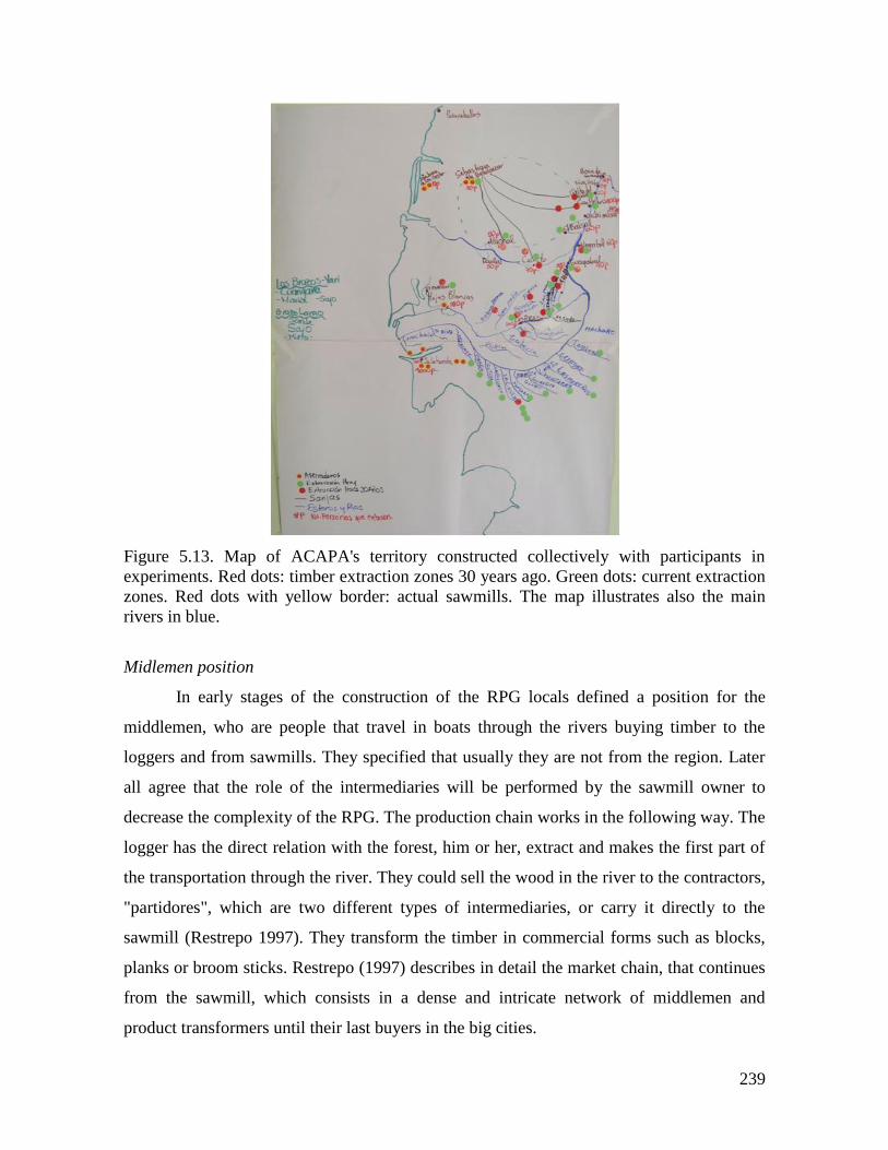
239
Figure 5.13. Map of ACAPA's territory constructed collectively with participants in
experiments. Red dots: timber extraction zones 30 years ago. Green dots: current extraction
zones. Red dots with yellow border: actual sawmills. The map illustrates also the main
rivers in blue.
Midlemen position
In early stages of the construction of the RPG locals defined a position for the
middlemen, who are people that travel in boats through the rivers buying timber to the
loggers and from sawmills. They specified that usually they are not from the region. Later
all agree that the role of the intermediaries will be performed by the sawmill owner to
decrease the complexity of the RPG. The production chain works in the following way. The
logger has the direct relation with the forest, him or her, extract and makes the first part of
the transportation through the river. They could sell the wood in the river to the contractors,
"partidores", which are two different types of intermediaries, or carry it directly to the
sawmill (Restrepo 1997). They transform the timber in commercial forms such as blocks,
planks or broom sticks. Restrepo (1997) describes in detail the market chain, that continues
from the sawmill, which consists in a dense and intricate network of middlemen and
product transformers until their last buyers in the big cities.
240
Communitarian Council position (ACAPA)
The participants in the collective construction of the RPG defined a function and a
set of actions for the Communitarian Council (CC). The function defined in the game was:
"As territorial organization its function is to defend the territory, and contribute to
improve life quality of rural communities. To support the community in the
formulation of plans and projects, which benefit the communities inside the
territory of the Communitarian Council". (RPG collective construction workshop,
June 20/2008)
The actions linked to this position were: to build awareness on each individual in the sense,
that the territory is a collective property in benefit of the community.
Representatives of the CC's Junta (Board of Directors) present in the workshop,
expressed their main concerns which had to do with the Forestry Land Use Plan and its
coordination with the Municipal Development Plan. I must remind here two characteristics
of the CCs: (1) their competence is in the rural part of the municipalities, but not the urban
settlements, and (2) their legal and administrative nature is different from the municipality
administration. Therefore, the coordination between municipal land use plans and the CCs
planning actions is in many cases difficult and has to go through the filter of local politics
and economic interests.
One of the sawmill owners' opinion about ACAPA, it is the organization that is
doing something in management and rule enforcement, he said that "people from the
"negritudes" control more, this is a phantom village, here there is no law, the village major
does not tax anything" (Interview with a sawmill owner, Salahonda 2007). The "negritudes"
is a way to refer to all issues related to the Process of Black Communities of the Pacific
Coast of Colombia (PCN), which is one of the main drivers of the Law 70 (1993) and the
Comunitarian Councils. Even though all the Afro Colombians living in ACAPA's territory
are part of the CC, at local level not all the people seem to have a belonging sense to the
movement. In general interviewed loggers link their opinions about ACAPA with the land
property rights issue. There is also a consensus about the declining in the CC's strength
since 2001. Scholars have profusely documented and analyzed the CCs processes in the
Pacific Colombian region since the decade of 1980s, even before the Law of Black
241
Communities (Law 70) in 1993. The research has been done fundamentally from political
ecology, geography and anthropology domains, the work of Arturo Escobar (1998 and 2001
among others publications) has largely contributed to the understanding of what I name in
this dissertation the socio ecological system of the "Chocó Biogeográfico". Particularly,
Rivas (2001) has studied the history of ACAPA, while Ospina (2008) reconstructed the
history of forest use since the decade of 1950s.
Regional environmental authority position
The second relevant issue is the licensing for timber harvesting. According the participants,
each logger has to ask for a license to the environmental agency (Corponariño) to cut trees.
The test of the game was played assuming this procedure and the representative of this
entity put a price for each license. During the final game with the real Corponariño officer,
the dynamics was quite different; the officer asked for licenses only to sawmills and he
explained that the individual loggers do not need license.
Table 5.10 Positions and actions of the RPG's action situation.
Grey rows illustrate the positions mentioned initially by participants but not included in the
final design of the RPG.
POSITION ROLE/ FUNCTION/OBJECTIVE/RULES ACTIONS
Loggers ROLE: To cut trees. To control their property.
FUNCTION: Sustainability of the forest and territory.
OBJECTIVE: To improve life quality with a productive
project different to forestry logging (agriculture) and to
crop another wood species.
RULE: 1) to cut trees minimum of 14 inches of diameter.
2) To control the neighborhood.
To allocate effort to: tree harvesting,
fishing or agriculture activities.
To sell the timber to the middle men
Timber buyers (sawmill
owners)
To buy timber. To Transform the wood. To finance
loggers.
To buy timber
Intermediaries -
middlemen
To buy timber to the sawmill or logger directly. They do
not live in the zone. It was proposed in the beginning, but
finally it was not implemented.
Chain-saw men 1 To cut trees with the power saw. During the game, some
of the loggers were chain- saw men. In contrast with
loggers, they do not own land; they are hired to cut trees.
To allocate effort to: tree harvesting,
fishing or agriculture activities.
To sell the timber to the middle men

242
ACAPA FUNCTION: As territorial organization its function is to
defend and to watch over the territory, and contribute to
improve life quality of rural communities. To support the
community in the formulation of plans and projects,
which benefit the communities inside the territory of the
Communitarian Council.
To build awareness on each
individual that the territory is a
collective property in benefit of the
community.
Governmental Regional
environmental agency
(Corponariño)
To regulate the use of the forest. To guarantee a good
forest exploitation.
To issue exploitation and
mobilization licenses. Forest
harvesting licenses have a monetary
cost, people has to pay in order to get
the permit.
Local police To solve possible conflicts of invasion to forest
properties. To enforce the boundaries of properties. To
solve fast the conflict with justice. To monitor timber
harvesting of endangered species. To support
Corponariño. It was proposed in the beginning, but
finally it was not implemented.
Municipal administration It was proposed in the beginning, but finally it was not
implemented in the game.
1
This position was explained initially but it was not formally included in the RPG. During the game playing
some of the players said that they were playing as chain-saw men.
Resource diversity and growth dynamics
Participants started pointing that the forest in the real life was not homogeneous,
then, they said that for the game it was necessary to differentiate trees, as one of the
participants explained to the rest: “what we are doing is to translate the former game to the
situation we are living here, therefore, if we are living a forest in which there are variety of
species, then we must work it like this”. Then, they entered in a discussion about the
relevant species and their growth rates. They chose four species whose growth rates were
set in the following way: Cuangare37 and Sande38 species has the fastest growth rates; for
each 5 trees in the game board a new tree is born. Garza39 and Sajo40 species are slower; for
each 10 trees in the forest a new one is born. New trees of each species were located in the
zones of the board where there are more trees of this species. When a tree is cut the way
trees regenerate is the following: at the end of the round the trees of each species are
counted and the cell for the new tree is decided and a dot of the species color are drawn, at
37 Otoba gracilipes
38 Brosimum utile
39 Tabebuia rosea
40 Campnosperma panamensis
243
the end of the next round an adult tree is put in the board according to the color dots for
each species, then again the counting of the number of trees of each species is done and the
new color dots are put, and so on.
It seems to be a consensus about the growth rates of the main species and the forest
capacity to regenerates among local loggers interviewed. The Cuángare, most of the
interviewees said that a tree will last between 4 and 5 years to reach its harvest size. A tree
of 10 inches (diameter) grows up to 16 or 15 inches in 4 years, said another logger. Some of
the loggers said that there is overexploitation because there is no re-cropping of species.
For one of the interviewees the forest will not last more than 15 years. In contrast, a
sawmill owner said that "people say that in 7 years the timber finishes, but this is a lie
because always there is more" (Interview, 2007). He said also that, in general, the trees start
to grow again after 3 years, and specifically the Sajo species grows in 4 or 5 years from 8 to
12 inches when it is ready to harvest. The same interviewee explain that he does not believe
that the trees are declining, but at the same time he has noticed that in the last years people
have started to bring smaller pieces, even smaller than the minimum size allowed by the
environmental authority (Corponariño). Another logger said that some years before the
timber pieces "trozas" had 16 feet long, but now they have in average 12 feet. In other
interview is said that when the forest patch is in a very bad condition, they live resting the
patch from 8 to 10 years. Several loggers agree that one of the problems is that there is not
planting of new trees, this idea was discussed in the experimental results workshop, as well
as in some phases of RPG building.
In contrast, Del Valle (1993) reports the results of a research carried out in the
region by several forestry scientific studies, which main findings regarding tropical rain
forest growth are substantially different to what locals express in our interviews and
workshops. For the Sajo species (Campnosperma panamensis), a tree needs 57 years for
reach the minimum acceptable harvesting size of 40 cm (15.7 inches), starting from a
young individual of 5.2 cm (2 inches) of diameter. The Cuángare (Otoba gracilipes) species
lasts 59 years for reaching the same harvest diameter, starting the measure from 1.5 cm (0.6
inches) of diameter. One of the implications of these data is the fastest growth of Cuangare
compared to Sajo just like in the RPG dynamics for the natural regeneration of resource set
by participants. According to Mergen and Jeffrey (1987 in Del Valle 1993) regeneration
244
cycles in tropical forests has been estimated between 20 and 30 years. A study from the
Universidad Nacional de Colombia from 1990 (in Del Valle 1993) found that peasants in
this region come back to harvest forest patches after 10 to 15 years or even less after a
fallow period. The authors explain that short harvest cycles produce trees with increasingly
minor diameter with a low efficiency in the transformation processes, but also the trees are
damaged in their fastest phase of growth (Del Valle 1993).
Information available to participants
The information available for each position in the RPG was defined by participants.
All the information was public except the decisions and earnings for each participant. Since
the RPG simulated a timber market, the prices were negotiated between loggers and
sawmill owners in each round individually. There were some public fixed costs such as a
minimum amount that each logger had to pay to the game for assuring his permanence in
the game. If a logger chose not to extract timber in a round, the game paid him a minimum
amount of money, which was public, in order to remain in the game, this represented the
effort allocation to other activities such as fishing and agriculture. Players were allowed to
communicate freely. The forest natural dynamic was provided for all the players, as well as
the way in which each tree species were reproduced and assigned a place in the game
board.
Participants started by a discussion about the needs for a forestry management plan
and the principal need were to have a forestry inventory, they said. They talked about a
forestry inventory for the game, this is, each round to count the percentage of each species
and the number of trees by species present in the board. They wanted to go into details such
as a sampling plan for counting trees. This idea seemed to be very strong at this stage but at
the end they did not include any inventory in the game. They finally said that the forest
harvesting in the game was according to each player’s needs.
Actions and control over outcomes
The fundamental RPG's actions were defined when positions were discussed, but
the detailed actions were defined during the design of the mechanisms of the round. Due to
the insistence of participants in the economic transactions as a key driver of timber
245
extraction, we proposed to include fake money in the game in order to include incentives
and give sense to the role of players as sawmills owners given the fact that participants said
sawmills were important actors. Another important point was the insistence of people to
include in the game other economic activities such as fishing and agriculture as way to
achieve a sustainable management of the forest. Therefore, an initial amount of money was
given to loggers and the two sawmill owners. The mechanics of each round was defined in
the following way:
1- Each logger pays $ 20.000 representing the money for his family’s survival.
If the player decides do not go to harvest timber, it means he allocate his time to other
activities like fishing or agriculture and he receives $ 20.000.
2- If he decided to go to the forest then he must pay $20.000 representing
transportation and food expenses for the time in the forest.
3- The players go to the forest and cut trees and sell trees to the buyers intermediaries
(sawmills).
4- The game (facilitator) buys timber to the sawmills
5- The game (facilitator) count trees of each species and says how many new trees
of each one grow and where they grow.
End of the round.
The facilitator played the role of an external market. The money that each logger
had to pay in steps 1 and 2 was given to the game, which in turn bought the timber to
sawmills. In this way monetary circulation was assured during the game. The temporal
meaning of each round was set according to the discussion among participants who agreed
that each round represented one journey to the forest to cut trees which could last in
average 4 days. They stated that, to simplify the game, always the tide, in the game, was
going to be in its highest point that is the ideal condition to transport the wood towards the
sawmills.
According to the survey, 45% of people think that they have some influence in the
future, regarding making their territory a better place to live. 33.3% think they influence a
lot in their future, 13.3% not much, and 8.3% think that they do not influence at all. One of
the interviewees said "It is very difficult to change rules with Corponariño" (Logger,
Salahonda,April, 2007), in contrast with other two loggers who stated exactly with the
246
same sentence "You change the rules by yourself" (Salahonda, April, 2007), meaning that
they have control over the timber extraction in their own forest patches and businesses.
The control over outcomes in the SES action arena from the side of ACAPA's
inhabitants has important constraints produced by the armed conflict in the region,
especially since 2000 year. The detailed understanding of the armed conflict in this region
of Colombia is beyond the scope of this study, but in the understanding of SES' action
arena outcomes is important to have into account the essentials. This situation has had
consequences mainly in ACAPA's organization influence and action range. In the next
paragraphs I synthesize the recent history of the conflict and explain the main resulted
conditions for the dynamics of the action arena. During most of the 1990s decade the region
was a "peace refuge" as Restrepo (2005) named it. This period characterized by very
sporadic incursion of guerrillas but without any concrete actions, the zone was considered
as a resting zone for guerrillas. In 1997 occurred the first violent incursion in a village of
the region by the FARC guerrillas, but was in 2000 year that paramilitary groups formally
announced their presence in the zone. The year 2001 marks a milestone in ACAPA's
organization history. Comunitarian councils used to be supported in organizational and
project funding fields by several national and international NGOs among others. ACAPA's
strength was build with a close collaboration of the regional Catholic Church through the
"Pastoral Social”, the social division of the religious institution. In 2001 the director of this
organization was assassinated by paramilitary.
This event and the public threats to the communitarian councils by these armed ultra
right wing groups generated the displacement and the "strategic invisibility" of local leaders
that started and lead the process since the early 1990s (Restrepo 2005). From that year on
an armed territorial dispute has been developed between the radical leftist guerrillas, the
paramilitary groups and the governmental military forces trying to control these two
factions. Analysts and governmental sources coincide that the mentioned territorial dispute
was triggered by the coca production. Coca crops and business started to move from the
east of the country towards the South Pacific region since the second half of the 1990
decade, driven by governmental coca eradication policies. This process triggered a
population migration process of people that worked in other regions in this illegal
productive activity. Armed group fought by territorial dominium that implied the business
247
control. Geographically the Pacific region is in a privileged situation: a dense river network
and direct access to the sea, which is the main transportation way for product transportation
towards Central America and North America (Restrepo 2005).
The coca agriculture came along with an important immigration of small traders,
and peasants from the former main coca cultivation regions. This population brought a
different culture and economic style, but more important than that, it entailed a
modification of the premises of the early 1990s ethnic-territorial black movement. This
fundamental idea is that the organization process was being developed with a population
ranging between 90 and 95% of Afro-Colombian persons settled in the territory several
generations before, which constructed a particular relation with the territory (Restrepo
2010).
During the last ten years a wave of development policies have introduced the
agroindustrial development of African Palm mono plantations, and the so called mega
projects such as transnational terrestrial communication ways, touristic facilities and
mining projects. Scholars (Escobar 1998, 2004, 2008, Agudelo 2002, Villa 2003, Restrepo
2010) link the violence in the region to these projects. They coincide that the attempts of
integrate the region to a modern project of nation that have not been achieved since the XIX
century, and particularly, failed during the last three decades of the XX century, on the
contrary, has been achieved in about ten years through the combination of bullets, coca and
money (Restrepo 2010).
The consequences of this context affect directly the control over outcomes of the
action situation analyzed here.
Synthesis of the forestry RPG action situation collective construction
Participants in the co-construction of the game gave high importance to the diversity
of the resource, for them the homogeneous representation of the forest in the experiment
was very limited and simplistic for their reality.
Though during the design of the game the communitarian social organization
(ACAPA) participated and clarified some points about the use of the forest and inhabitants
responsibilities, it did not play an important role during the game; its role was quite passive.
248
Perhaps the most relevant issues during the game design, test and final playing, regarding
rules, was on one hand, the apparent contradiction between the formal and informal land
property regimes, and on the other the harvesting licensing issue. Regarding the land, the
formal institution is a collective property, but the informal arrangement evidenced in the
game, is an individual private regime. Licenses for timber extraction are issued by the
environmental agency (Corponariño). Before the final game people said the loggers should
have their licenses, in the test each logger bought their license to the player representing
Corponariño. In the final game, with a real representative of Corponariño, licenses were
issued only to sawmills, not to individual loggers.
The role game was important to make sawmills visible as important actors in the
forest management, which curiously have not been invited to any meeting of the forest use
plan. For the community the sawmills are out of the system and make part to the external
market, and that they are wealthiest people compared to the rest of the community. During
the game loggers could realize the perception and rationality of sawmills.
Participants insisted in the need of other productive options as a condition for the
sustainable use of the forest, and it was included in the game according to the objective set
the second day, “A game for the sustainable use of timber, fisheries and other activities”.
The behavior of players where consistent their idea of sustainability in terms of leaving the
forest rest and allocate their effort to fisheries and agriculture. At the end of the game some
of the participants, who did not participate in the design, pointed their disagreement in the
way the resource regenerates. Their main argument was that it was unfair that a person
conserves his forest and the benefits, meaning, growth of new trees take place in all the
forest. Then, people who do not leave the forest rest, and harvest every round, benefit and
earn more money. They said that the new trees should grow only in the land plots that
conserve the forest.
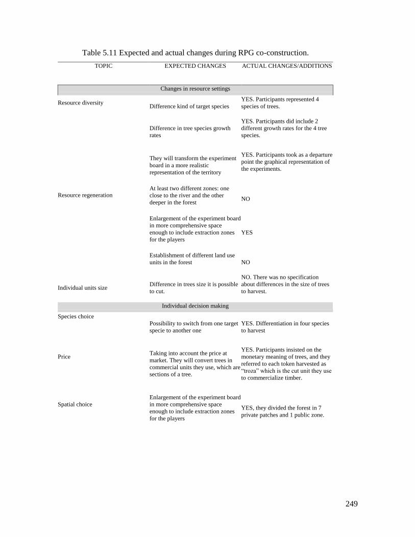
249
Table 5.11 Expected and actual changes during RPG co-construction.
TOPIC EXPECTED CHANGES ACTUAL CHANGES/ADDITIONS
Changes in resource settings
Resource diversity
Difference kind of target species
YES. Participants represented 4
species of trees.
Resource regeneration
Difference in tree species growth
rates
YES. Participants did include 2
different growth rates for the 4 tree
species.
They will transform the experiment
board in a more realistic
representation of the territory
YES. Participants took as a departure
point the graphical representation of
the experiments.
At least two different zones: one
close to the river and the other
deeper in the forest
NO
Enlargement of the experiment board
in more comprehensive space
enough to include extraction zones
for the players
YES
Establishment of different land use
units in the forest
NO
Individual units size Difference in trees size it is possible
to cut.
NO. There was no specification
about differences in the size of trees
to harvest.
Individual decision making
Species choice
Possibility to switch from one target
specie to another one
YES. Differentiation in four species
to harvest
Price
Taking into account the price at
market. They will convert trees in
commercial units they use, which are
sections of a tree.
YES. Participants insisted on the
monetary meaning of trees, and they
referred to each token harvested as
“troza” which is the cut unit they use
to commercialize timber.
Spatial choice
Enlargement of the experiment board
in more comprehensive space
enough to include extraction zones
for the players
YES, they divided the forest in 7
private patches and 1 public zone.
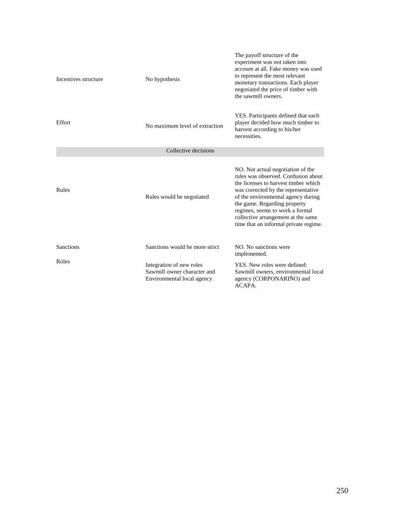
250
Incentives structure No hypothesis
The payoff structure of the
experiment was not taken into
account at all. Fake money was used
to represent the most relevant
monetary transactions. Each player
negotiated the price of timber with
the sawmill owners.
Effort
No maximum level of extraction
YES. Participants defined that each
player decided how much timber to
harvest according to his/her
necessities.
Collective decisions
Rules
Rules would be negotiated
NO. Not actual negotiation of the
rules was observed. Confusion about
the licenses to harvest timber which
was corrected by the representative
of the environmental agency during
the game. Regarding property
regimes, seems to work a formal
collective arrangement at the same
time that an informal private regime.
Sanctions
Sanctions would be more strict
NO. No sanctions were
implemented.
Roles
Integration of new roles
Sawmill owner character and
Environmental local agency
YES. New roles were defined:
Sawmill owners, environmental local
agency (CORPONARIÑO) and
ACAPA.
251
5.2.3 Outcomes of the forestry RPG action situation
In this section I discuss the outcomes of the forestry action situation starting with the
simplistic representation of the experimental setting. The section finishes with a discussion
on cooperation, trust and the level of conformance to general morality as the more relevant
results.
In the RPG the players could make two types of decisions: to go to the forest to cut
timber or allocate their turn to fish and agricultural activities. If a participant decided to
allocate its effort to fishing, implied do not go to the forest and received from the game
(facilitator) the money strictly necessary to survive this round. Population of different tree
species had two different growth rates. The place in which each new tree grew up depended
of tree, of the same species, abundance. Any tree lasted two rounds in being available for
extraction.
Figure 5.14 illustrates the game board during the 6 rounds of the game. In figure
5.15B it´s possible to observe the behavioral pattern of each one of the species of the forest.
The resource shows a general trend of decreasing with a slightly recuperation of the most
abundant species. Figure 5.14 shows the spatial evolution of the forest in the game board.
The forest zone with major changes corresponds to the lower part of the board, in which it
is evident an intense extraction. In this area, in round 6, the quantity of trees i slow
compared with the initial conditions, and less stable compared with the dynamics of the
superior part of the game board.
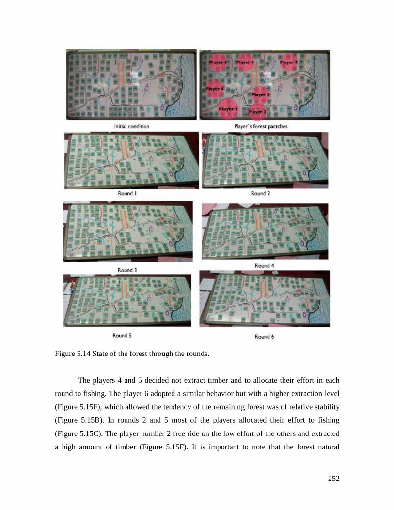
252
Figure 5.14 State of the forest through the rounds.
The players 4 and 5 decided not extract timber and to allocate their effort in each
round to fishing. The player 6 adopted a similar behavior but with a higher extraction level
(Figure 5.15F), which allowed the tendency of the remaining forest was of relative stability
(Figure 5.15B). In rounds 2 and 5 most of the players allocated their effort to fishing
(Figure 5.15C). The player number 2 free ride on the low effort of the others and extracted
a high amount of timber (Figure 5.15F). It is important to note that the forest natural
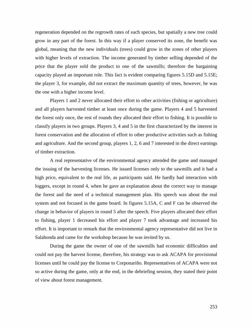
253
regeneration depended on the regrowth rates of each species, but spatially a new tree could
grow in any part of the forest. In this way if a player conserved its zone, the benefit was
global, meaning that the new individuals (trees) could grow in the zones of other players
with higher levels of extraction. The income generated by timber selling depended of the
price that the player sold the product to one of the sawmills; therefore the bargaining
capacity played an important role. This fact is evident comparing figures 5.15D and 5.15E;
the player 3, for example, did not extract the maximum quantity of trees, however, he was
the one with a higher income level.
Players 1 and 2 never allocated their effort to other activities (fishing or agriculture)
and all players harvested timber at least once during the game. Players 4 and 5 harvested
the forest only once, the rest of rounds they allocated their effort to fishing. It is possible to
classify players in two groups. Players 3, 4 and 5 in the first characterized by the interest in
forest conservation and the allocation of effort to other productive activities such as fishing
and agriculture. And the second group, players 1, 2, 6 and 7 interested in the direct earnings
of timber extraction.
A real representative of the environmental agency attended the game and managed
the issuing of the harvesting licenses. He issued licenses only to the sawmills and it had a
high price, equivalent to the real life, as participants said. He hardly had interaction with
loggers, except in round 4, when he gave an explanation about the correct way to manage
the forest and the need of a technical management plan. His speech was about the real
system and not focused in the game board. In figures 5.15A, C and F can be observed the
change in behavior of players in round 5 after the speech. Five players allocated their effort
to fishing, player 1 decreased his effort and player 7 took advantage and increased his
effort. It is important to remark that the environmental agency representative did not live in
Salahonda and came for the workshop because he was invited by us.
During the game the owner of one of the sawmills had economic difficulties and
could not pay the harvest license, therefore, his strategy was to ask ACAPA for provisional
licenses until he could pay the license to Corponariño. Representatives of ACAPA were not
so active during the game, only at the end, in the debriefing session, they stated their point
of view about forest management.
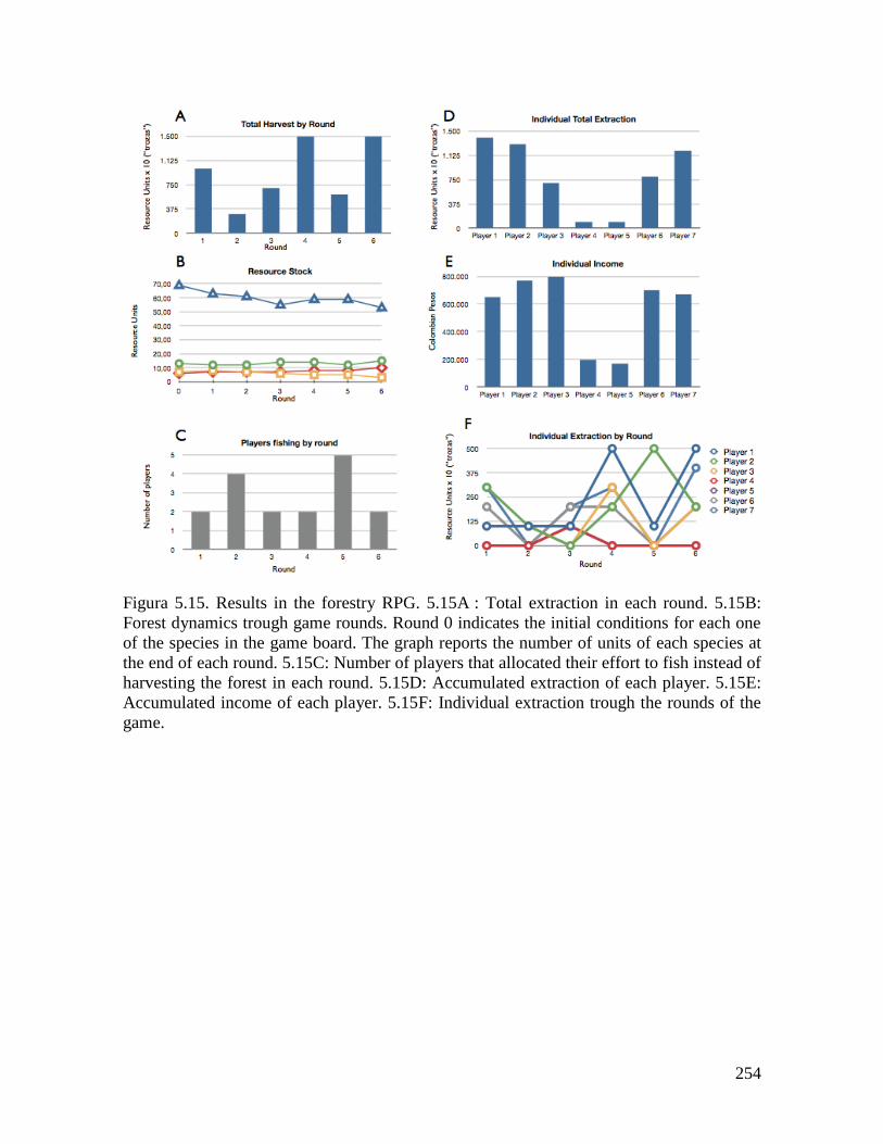
254
Figura 5.15. Results in the forestry RPG. 5.15A : Total extraction in each round. 5.15B:
Forest dynamics trough game rounds. Round 0 indicates the initial conditions for each one
of the species in the game board. The graph reports the number of units of each species at
the end of each round. 5.15C: Number of players that allocated their effort to fish instead of
harvesting the forest in each round. 5.15D: Accumulated extraction of each player. 5.15E:
Accumulated income of each player. 5.15F: Individual extraction trough the rounds of the
game.
255
5.2.4 Institutional arrangements in the forestry SES
Formal rules
Sorting the rules through the ADICO (Table 5.12) and AIM (Table 5.13) allows observing
the tendency of formal institutional arrangements. There are two characteristics of rules
according to their aims. On one hand, the regulation is focused on biodiversity
conservation, but on the other, the form in which the rules involve people, consists in
giving them the responsibility for forest conservation and forest sustainable use. The law
itself interprets the region as a social-ecological system, claiming an ancestral development
of culture strongly linked to the tropical forest, rivers and seashore. The definition of
concrete rules of the game is centralized in the regional governmental environmental
agency (Corponariño). This agency has to define monitoring mechanisms, forest use
permits and sanctioning systems. This responsibility is given by the national level rules as
well as the local communitarian rules.
The rules with local influence (8 and 9 in tables 5.12 and 5.13) are created by the
Communitarian Council (ACAPA). They are focused in the control of the sizes of trees
harvested and a ban of one of the species (Naidi palm). The sanctions ("or else" element)
for violators are left to the governmental environmental local agency (Corponariño).The
ban of the palm caused the retirement of 3 veredas from the communitarian council and
constituted a new council ("Veredas Unidas por un Bien Común") which was entitled with
the common land property title. They organized themselves with the technical advice of a
forestry engineer contracted by one of the external companies interested in the exploitation
of the palm (Rivas 2001). According this author in the late 1990s, among ACAPA's
inhabitants there were a feeling about the Law 70 that the law represented a developmental
delay because was generating restrictions on natural resources use. The other relevant rule
(rule 8 tables 5.12 and 5.13) recognizes the key role of saw mills in shaping the use and
conservation of the forest, by regulating the minimal size of individual logs allowable to
purchase to the loggers.
Table 4 shows the classification of the rules according to their AIM of the rules in
the action situation. Position rules (1, 2, 3, 6 and 7) define who is to give permits and
licenses for timber extraction (rule 1), which is Corponariño, the local environmental
agency. Rules 2 and 3 establish that local black communities are the users of the tropical
256
forest, but also they define this position with the role of forest and, in a broader sense, of
biodiversity keepers. Rule 6 allocates to the commercial companies the role of monitoring
the licenses of loggers and timber transporters. Rule 7 involves police and military
members in the role of supporting environmental agencies in monitor and control of rule
compliance. Regarding boundary rules, rule number 2 defines the eligibility of local Afro
Colombian inhabitants for having the position of users of the forest, as well as its keepers.
Concrete choice rules were created locally by the comunitarian council ACAPA,
and are oriented to the people (rule 9) and to the saw mills (rule 8). Rules of national and
regional scale regulate in a generic form the direct decisions on timber extraction. The most
important choice rule has been the banning of the Naidi palm41 extraction (rule 9), which
has had important consequences to ACAPA. The control through the saw mills and the
issuing of licenses is based on the exigence of a forest management plan that must include a
detailed forestry inventory and a harvesting plan that ought to be elaborated or advised by a
forestry engineer and submited to the local environmental agency, Corponariño. The formal
institutional system strongly relies on this management plan as the main source of
information for the regulation of forestry use. Therefore, this plan, which is required by the
Forestry Use Decree to any actor that intends to harvest the forest, becomes the main
information rule of the system. The planning is required for any kind of licensing to extract
timber, if no plan is presented, no license is issued. Therefore, a participant of the action
situation who extracts timber without compliance of this planning is subject to the sanctions
defined by the local environmental authority. Most of the rules are scope rules (3, 4, 5, 8
and 9). Their aims are to protect the tropical rainforest, to warrantee a sustainable use of the
forest, and to protect the Naidi palm and allows its natural regeneration.
41 Euterpe oleracea
257
Table 5.12 Formal statements ADICO syntax components
STATEMENT ATTRIBUTE DEONTIC AIM CONDITION OR ELSE TYPE
1. Regional environmental agencies (i.e.
Corponariño) have to issue concessions, permits
and authorizations for renewable natural
resources use and/or their transportation.
(Environmental Law 99/1993)
Public regional
and local
environmental
agencies
Regional and
local public
environmental
agencies must
monitor and give
permits for the
use and
mobilization of
RNR
To transfer the
responsibility to
monitor and
regulate use to
the regional and
local scales.
Colombian
territory
Investigation
and
correspondin
g sanction, by
a
governmental
agency, for
not fulfill a
constitutional
mandate
Rule
2. The State will allocate to the black
communities collective property rights over the
lands adjacent to the rivers in the Pacific Basin,
which have been occupying through their
traditional productive practices (Black
Communities Law 70/1993)
Afro Colombian
citizens
The State must
give collective
property rights of
lands
traditionally
occupied
To allocate
collective land
property rights
to Afro
Colombian
citizens
Colombian
Pacific region
Investigation
and
correspondin
g sanction, by
a
governmental
agency, for
not fulfill a
constitutional
mandate
Rule
3. The use of the forest must warrantee the
persistence of the resource. The collective land
titles have a social and ecological function
(Black Communities Law 70/1993)
Afro Colombian
citizens
Afro Colombian
communities
must use in a
sustainable form
the tropical rain
forest, and be
responsible for
its conservation.
To make
responsible the
Afro
Colombian
communities
entitled by the
collective titles
of the
conservation of
the tropical
rainforest
ecosystem
Colombian
Pacific region
Sanctions are
defined by
the public
local
environmenta
l agency
(Corponariño
)
Rule
258
4. In order to harvest a forest located in public
and private lands, the corresponding local
environmental agency (Corponariño) will issue a
license, concession or association, based on a
forestry management plan presented by the
beneficiary of the exploitation.
(Forestry Use Decree 1791/1996)
Any person who
is interested in
exploiting
forestry
resources.
Any person
interested in the
exploitation of
forests must
design a forestry
management plan
in order to obtain
a license,
concession or
association from
the local public
environmental
agency.
To assure a
sustainable
forestry use.
Colombian
territory
The potential
beneficiary
will not have
the
authorization
for exploiting
the forest.
Rule
5. Forestry exploitations intended by black
communities are ruled by the Law 70, but the
aspects not specified in that law are ruled by the
Forestry Use Decree 1791/1996.
(Forestry Use Decree 1791/1996)
Afro Colombian
population
Forestry use
must be ruled by
Law 70 or the
Forestry Use
Decree
1791/1996
To assure a
sustainable
forestry use.
Colombian
territory
entitled as
collective
lands to Afro
Colombian
people.
Sanctions are
defined by
the public
local
environmenta
l agency
(Corponariño
)
Rule
6. The commercial companies that transform,
commercialize and transport forestry products
(saw mills and other intermediaries) are obliged
to demand to the suppliers (loggers, small saw
mills and other timber transporters) a license that
warranties the legal transportation (Forestry Use
Decree 1791/1996)
Colombian and
foreigners
citizens
Any company or
person that
transport timber
must have a
license issued by
the local
environmental
authority.
To monitor and
control the
extraction and
mobility of
timber forest
products.
Colombian
territory
Seizing of the
timber.
Rule
7. Local and regional environmental agencies are
to monitor and control the use of the forests.
These agencies must coordinate with police and
military these activities. (Forestry Use Decree
1791/1996).
Colombian
governmental
local and
regional
environmental
agencies
All local and
regional public
environmental
agencies must
control and
monitor the use
of forests.
To monitor and
control the use
of the forests.
Colombian
territory
Investigation
and
correspondin
g sanction, by
a
governmental
agency.
Rule
8. Limitation to saw mills (ACAPA 1997) Saw mills
working in
ACAPA's
territory
It is forbidden to
buy logs smaller
than 4 inches
diameter
To facilitate the
natural growth
of the forest
ACAPA
territory
Correspondin
g sanction
applied by the
local public
environmenta
l angency
(Corponariño
)
259
9. Ban on Naidi palm (ACAPA 1997) Afro Colombian
population
member of
ACAPA
It is forbidden to
harvest Naidi
palm
To foster and
protect the re-
growth of the
Naidi palm
ACAPA's
territory
Correspondin
g sanction
applied by the
local public
environmenta
l angency
(Corponariño
)
Table 5.13 Formal institutional statements classified according their purpose
INSTITUTIONAL STATEMENT SCALE CREATO
R/YEAR AIM
TYPE
Position: 1, Boundary: 2,
Choice: 3, Aggregation: 4,
Information: 5, Payoff: 6,
Scope: 7.
1 2 3 4 5 6 7
1. Regional environmental agencies (i.e. Corponariño) have to issue
concessions, permits and authorizations for renewable natural
resources use and/or their transportation.
(Environmental Law 99/1993)
National/R
egional
Central
gov/
1993
To define who
must regulate
the use of the
forest.
X
2. The State will allocate to the black communities collective
property rights over the lands adjacent to the rivers in the Pacific
Basin, which have been occupying through their traditional
productive practices (Black Communities Law 70/1993)
National Central
gov/
1993
To allocate
collective land
property rights
to Afro
Colombian
citizens
X X
3. The use of the forest must warrantee the persistence of the
resource. The collective land titles have a social and ecological
function (Black Communities Law 70/1993)
National Central
gov/
1993
To protect the
tropical
rainforest
ecosystem
X X
4. In order to harvest a forest located in public and private lands, the
corresponding local environmental agency (Corponariño) will issue
a license, concession or association, based on a forestry management
plan presented by the beneficiary of the exploitation.
(Forestry Use Decree 1791/1996)
National/R
egional
Central
gov/
1996
To assure a
sustainable
forestry use.
X
5. Forestry exploitations intended by black communities are ruled by
the Law 70, but the aspects not specified in that law are ruled by the
Forestry Use Decree 1791/1996.
(Forestry Use Decree 1791/1996)
National/R
egional
Central
gov/
1996
To assure a
sustainable
forestry use.
X
6. The commercial companies that transform, commercialize and
transport forestry products (saw mills and other intermediaries) are
obliged to demand to the suppliers (loggers, small saw mills and
other timber transporters) a license that warranties the legal
transportation (Forestry Use Decree 1791/1996)
National/R
egional
Central
gov/
1996
To monitor and
control the
extraction and
mobility of
timber forest
products.
X
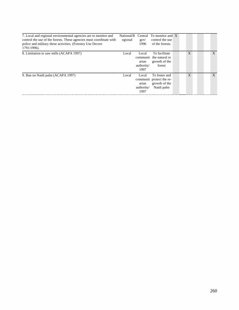
260
7. Local and regional environmental agencies are to monitor and
control the use of the forests. These agencies must coordinate with
police and military these activities. (Forestry Use Decree
1791/1996).
National/R
egional
Central
gov/
1996
To monitor and
control the use
of the forests.
X
8. Limitation to saw mills (ACAPA 1997) Local Local
communit
arian
authority/
1997
To facilitate
the natural re
growth of the
forest
X X
9. Ban on Naidi palm (ACAPA 1997) Local Local
communit
arian
authority/
1997
To foster and
protect the re-
growth of the
Naidi palm
X X
261
Rules in use
Analysis of the interviews, RPG and surveys gave an approximation to the rules in use
in the forest use in ACAPA´s territory. Interviews carried out by Ospina (2008) also
constitutes a useful source of information for the understanding of rules that participants
really use in their daily lives. Relevant fields for the forestry management discussed
here are land property rights, licenses and permits, sanctions and monitoring, the
management of certain species such as the Naidi palm and mangroves, the role of the
saw mills, and forest harvesting.
Land property rights
The ownership of the land is equivalent to the ownership of the forest. Traditionally
there were no official land titles in the zone, but the dominion of the land has been
individual through de facto titles inherited from generation to generation in some cases,
and others through the exploitation of the untouched forest. The law has transformed the
possession of the land since 1993, and has given formal collective land titles to these
communities. The result is a combination of formal and informal land ownership
depending on the interlocutor and the specific situation. During the RPG collective
construction, the forest represented in the board game was divided in zones, which
represented the forest patch of each player. During the RPG each player harvested
timber from its own forest patch in the board game. Only the coastal zone, with
mangrove trees symbolized with a red cross, was depicted as common lands.
Interviewees expressed the land ownership rules in different ways saying that people
respect the borders of the forest patches until the owner dies. Locals explain that the
forms of access to the land are basically inheritance, work (“meterle zanja” meaning
building a canal in the forest to extract timber), or land buying (Ospina 2008). Most of
the interviewees expressed their critics to the collective land title based on the loss of
rights to sell their lands. Only few respondents expressed their agreement with the
collective title because with this status is easier to obtain financial support from
international and national entities for development projects (Ospina 2008 and interviews
and informal chats carried out in the context of the field work for this research).
Licenses
During RPG design participants proposed that each logger would need a license each
round according to the state of the forest. It implied an assessment of the state of the
262
forest at the end of each round, which was proposed by some participants, but during
the final playing of the game this rule was not applied. At the moment of the activity
one of the main concerns was the forest management plan that ACAPA was leading,
therefore, they made emphasis during the co-construction of the RPG on its usefulness
for that purpose. When playing the RPG, the environmental authority issued extraction
licenses but for the saw mills. Each saw mill owner bought a license at the beginning of
each round. People expressed in the interviews exactly the same mechanism for timber
extraction licensing.
The Naidi Palm
During the first years of the communitarian council, the extraction was completely free
and was one stable source of income for most of the population. This situation led the
species almost to its extinction. During the 1990s the extraction was driven by the
quality of the palm, which is a function of the size of the inner core of the plant. The
price was set according to the product´s size. The extraction was completely free, and
the principal rule was the differential price with the consequences already mentioned. In
1999 ACAPA managed to make the environmental authority to ban drastically the Naidi
palm extraction. The prohibition lasted during six years, and was one of the actions that
affirmed the rights over the collective territory. In 2006 the exploitation of the palm was
reactivated. This time the communitarian council regulated the extraction through out
agreements with buyers, in which they only buy the best quality palm. This implied that
loggers harvested only the most mature individuals (Ospina 2008).
The mangroves management rules
The rules for the use of the mangroves´ timber were also pushed by ACAPA. Initially
the coastal territory with mangroves was not included in the collective title, but the
communitarian council managed, using legal and political instruments, to keep this vital
space inside its territoriality. They used the argument of their cultural practices and the
sustainable management as arguments for claim their right to design their own rules for
the mangroves forests (Rivas 2001). As a result, people can use the mangrove only for
domestic use such as own house and artisanal boat building (Ospina 2008). The
participants in the RPG collective design established a zone with mangroves trees,
which symbol was an X. During the game any of the players harvested those trees.
263
General monitoring and sanctions
Interviewees agreed that the environmental local authority monitors each 2 or 4 years.
They coincided in that the minimum harvesting size of timber is 16 inches of diameter,
and that when the environmental agency monitors check the size and licenses to the saw
mills. Regarding the sanctions, they expressed that when the agency´s officers catch
someone breaking the rules, the first time they give a verbal advertence and the second
time a fine is imposed. During the RPG it was evident that the negotiation with the
middle men, in this case the owner of the saw mills, was shaping the extraction of
timber. Most of the time the representative of the environmental agency (Corponariño)
was issuing licenses to the two saw mills in the RPG. Only during one of the rounds he
discuss with loggers the state of the forest and gave advice about good forest harvesting
practices and the forest use plan, using the game board as an illustrative tool.
Timber harvest
The general rules in use for timber extraction can be understood at two scales:
individual level and daily use of the forest on one hand, and on the other, the general
consequences of the Law 70. Interviewees agreed in 4 basic rules that they followed in
their activity: (1) rights to the forest; a forest patch can be appropriated by building
infrastructure for harvesting only if the place does not have already an owner, this
practice legitimates a person as owner of that piece of land, sometimes there are
conflicts because of invasion of others` forest, but in general the rule seems to be the
fundamental form of forest appropriation. (2) The places on which they do not harvest
are the banks of the rivers and the mangrove zones. (3) The minimum size that people
harvest is a range between 12 and 15 inches of diameter. From interviews with saw
mills´owners and field visits to some of the facilities, we conclude that, depending on
the economic situation they can accept buying, or demand to the loggers smaller
diameters of timber. (4) The time to leave resting a patch of forest, called the return time
oscillates between 2 to 10 years. At global scale, the Law 70 marked a milestone for the
use of the forest. One of the changes due to its implementation was the impossibility of
the national and international companies of entering to the zone with licenses of the
National government. After the law, in practice, it has been difficult to the National
government to facilitate the entrance of logging companies into the zone. In fact, in
2006 the government proposed the “Forestry Law” to the National Congress, which part
of the aim was to make possible logging companies to enter in the region. So far the law
264
has been blocked through political lobby of environmentalists and Afro American
leaders.
The purpose of the rules
The AIM classification of rules contributes to describe the forestry action arena
and the interactions among actors.
Position rules: The direct extractors of timber belong to ACAPA. ACAPA
members own the sawmills but they are not direct extractors. Other middlemen not
necessarily belong to ACAPA members, they represent the commercial connection of
the SES with others systems.
Boundary rules: The entry and exit rules are clearly defined by ACAPA`s Board
of directors. But they can issue timber extraction licenses to external companies. This
has happened with the extraction of Naidi palm for example. Not always this capacity of
this committee has been transparent. The economic interest and the different type of
pressures from external companies, illegal armed actors and politicians has led to
allowing the big scale timber extraction.
Choice rules: In terms of the rules, which aim is to structure the decision making
of the participants in this SES there are two findings that have to be remarked. The
extraction decisions of timber loggers are shaped by the middlemen demand. This is
most important that what the formal rule could prescribe, meaning that this is the rule in
use not the formal one. The second one is that the loggers have wide range span in their
conceptions of the time necessary to let trees to regrowth. The range is between two and
ten years. According to this notion they leave resting the forest patches to allow natural
regeneration.
Payoff rules: This type of rules in this SES are not related with sanctions. The
rule works with any species that is allowed to harvest, but the middlemen shape it also.
Currently, the harvest of Naidi palm is allowed after several years of prohibition due to
overexploitation. The buyers demand the biggest palms, this fact which entails a
problem for the maintenance of the species, because the extraction should be done of
middle size individuals.
Next table (5.14) summarizes the rules in use in the forestry system. Similarly to
the fishery case, they present an ADIC structure, therefore we are dealing with "norms”,
they lack a clear OR ELSE component. These norms directly affect the components of
the action arena and shape its outcomes discussed in the next section. Table 5.14 also
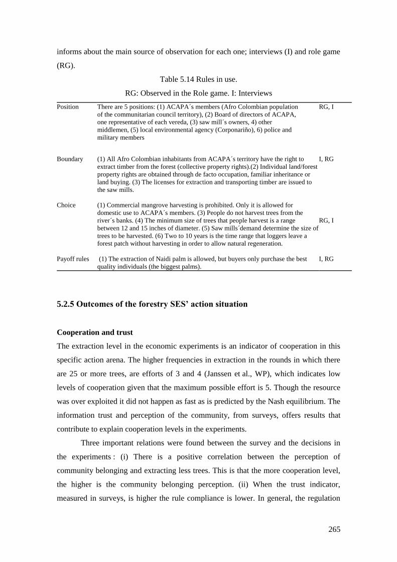
265
informs about the main source of observation for each one; interviews (I) and role game
(RG).
Table 5.14 Rules in use.
RG: Observed in the Role game. I: Interviews
Position There are 5 positions: (1) ACAPA´s members (Afro Colombian population
of the communitarian council territory), (2) Board of directors of ACAPA,
one representative of each vereda, (3) saw mill´s owners, 4) other
middlemen, (5) local environmental agency (Corponariño), 6) police and
military members
RG, I
Boundary (1) All Afro Colombian inhabitants from ACAPA´s territory have the right to
extract timber from the forest (collective property rights).(2) Individual land/forest
property rights are obtained through de facto occupation, familiar inheritance or
land buying. (3) The licenses for extraction and transporting timber are issued to
the saw mills.
I, RG
Choice (1) Commercial mangrove harvesting is prohibited. Only it is allowed for
domestic use to ACAPA´s members. (3) People do not harvest trees from the
river´s banks. (4) The minimum size of trees that people harvest is a range
between 12 and 15 inches of diameter. (5) Saw mills´demand determine the size of
trees to be harvested. (6) Two to 10 years is the time range that loggers leave a
forest patch without harvesting in order to allow natural regeneration.
RG, I
Payoff rules (1) The extraction of Naidi palm is allowed, but buyers only purchase the best
quality individuals (the biggest palms).
I, RG
5.2.5 Outcomes of the forestry SES’ action situation
Cooperation and trust
The extraction level in the economic experiments is an indicator of cooperation in this
specific action arena. The higher frequencies in extraction in the rounds in which there
are 25 or more trees, are efforts of 3 and 4 (Janssen et al., WP), which indicates low
levels of cooperation given that the maximum possible effort is 5. Though the resource
was over exploited it did not happen as fast as is predicted by the Nash equilibrium. The
information trust and perception of the community, from surveys, offers results that
contribute to explain cooperation levels in the experiments.
Three important relations were found between the survey and the decisions in
the experiments : (i) There is a positive correlation between the perception of
community belonging and extracting less trees. This is that the more cooperation level,
the higher is the community belonging perception. (ii) When the trust indicator,
measured in surveys, is higher the rule compliance is lower. In general, the regulation
266
led to lower levels of over exploitation, but also to high degree of rule breaking. (iii)
The higher the resource decrease, the extraction levels are lower42 (Janssen et al., WP).
The results from the RPG offer insights about the current and potential levels of
cooperation. It is possible to divide the cooperation levels according two concepts: (1)
current and potential cooperation among actors, and (2) cooperation understood as the
extraction level. Regarding the first kind of cooperation, it was evident in the RPG
construction as well as during the game. In the co-construction of the game were
explicit the calls to count with the sawmill owners and middlemen to reach cooperation
agreements. During the game was evident the key role of these actors in the extraction
and in the forest dynamics.
At the end of the RPG the representatives of the sawmills expressed their
willingness to participate and cooperate with the Forestry Management Plan of ACAPA
(Communitary Council). The role played by the representative of the public
environmental agency (Corponariño) can be defined as moderated willingness to
cooperate. The official worker of the agency, during the first rounds of the RPG only
sold extraction licenses to the sawmills without doing any intervention in the game
board neither a monitoring function. In round number 4 the officer intervened using the
board as illustrative tool. He suggested several good practices of forest extraction and
sustainable management, and also he stated the official position of the environmental
agency regarding the Forestry Management Plan. In his intervention he utilized the
board but always spoke about the regional forest. The inference is that there is an
important level of willingness to cooperate with the Communitarian Council, and the
direct forest users. The participation of the Communitarian Council (ACAPA) was
mainly passive and showing low interest. This behavior can be interpreted as a signal of
the internal problems and conflicts of the directive committee of the organization. An
important fact is that the communitarian organization ACAPA has a very recent history
that has been strongly influenced by the armed conflict. It is evident, and it was verified
in the fields work that still there are no clear conflict resolution in the organization.
The behavior of the forest direct users in the RPG can be typified in three
classes: high, moderated, and low cooperation. Two of the players (players 4 and 5,
Figure 8) made extraction decisions aiming to conserve the forest. In addition to their
42 Two types of analysis were used: i) Multi-level linear regression with the dependent variable the relative resource
extraction and independent variables: the level of trust, the level of feeling being part of the community. And ii) a
multinomial logistic regression (Janssen et al. WP)
267
decisions, in the discourse, they tried to induce the same behavior to the other
participants. The player 3 exhibited an intermediate level of cooperation, who extracted
timber moderately and negotiated efficiently with the saw mills, in this way he did not
generated a big impact in the forest and obtained the higher accumulated earnings in the
game (Figure 5.15E). The players 1, 2, 6 and 7 had the higher level of extraction and
exhibited free rider behavior in rounds 4, 5, and 6 (Figure 5.15F).
According to one of the sawmill owners interviewed, the tendency during recent
years is that the extractors bring from the forest timber smaller than permitted by the
environmental authority. This fact indicates low levels of cooperation from the
extraction and market perspective, because the sawmill buys this timber. Though there
is no concrete information about the policies of other saw mills regarding this practice,
from informal conversations with timber extractors, is generalized the idea according
that small sizes of timber is the one that can be sold always. This implies a systematic
breaking of formal rules of timber extraction and buying. For timber extractors the
cooperation with the sawmill is vital because the sawmill provides the economic
resources in advance to the extractor to go to the forest. In turn the sawmill depends on
the extractors to obtain the material for its business. According to some of the
interviewees (Ospina, 2008), when a sawmill is closed or moved to other zone it is
perceived by the extractors as a type of betrayal to the trust and to the relationship that
has been built during a considerable time period.
The interviewees speak about a generalized tendency to the cooperation
decrease. A young timber extractor woman states, “here people is going to continue
extracting the same quantities, but if they could, they would extract even more”
(Interview, Salahonda, April 13, 2007). The cooperation practices among the direct
users like the “cambio de mano”43 are not so common nowadays in contrast with
previous generations as expressed by one of the interviewees: “the people is driven
mainly for the money”, and says that people of 30 and younger do not like the “cambio
de mano”, but people that started to work before the 80s still practice this kind of
cooperation organization (Ospina, 2008). Another interviewee talks about the
“minga”44, but he says that it is very rare nowadays because “currently the business is
43 Practice that consists in a gathering of a extractors group to help to harvest the forest patch owned by
one person. Afterwards, the same group gathers to help in each member´s forest. 44
The “minga” is a cooperation form where the owner of the forest patch offers food and drinks to a
group of people, and people helps in the timber extraction. The difference with the “cambio de mano” is
268
becoming so hard, there is no means to leave money to the wife, to the sons to eat,
therefore, each one asks for his payment (…) before was better, the work was done
faster” (Ospina, 2008).
The trust in community leaders, this is the members of the Directive Committee
of ACAPA, has been eroding since 2001, when illegal armed groups killed the leader of
an external organization that supported the process. Several interviewees say that do not
have information about the Communitarian Council and that they do not feel themselves
as part of the organization. They coincide in that the resources are poorly managed
without following commitments and agreements, but overall they feel that do not
participate in decisions. Escobar (Escobar, 2005) analyzes the organizational process of
afro Colombian communities in the South Pacific Coast and finds that the generation of
new leaders which is replacing the people from the 90s, the so called “new leaders”, are
adopting an adaptive strategy to the armed conflict that has triggered a considerable
effect in the trust decrease from the community, and the consequence has been the
internal corruption.
Rules and general morality conformance
The individual and collective morality as a result of the action situation and a
particular trajectory of institutional arrangements. Table 7 illustrates the components of
the first and second level of morality conformance.
that the “minga” does not entails a laboral Exchange, it is only a contribution withouth any obligation to
particiapte in another “minga” in the future.
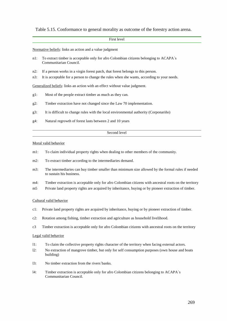
269
Table 5.15. Conformance to general morality as outcome of the forestry action arena.
First level
Normative beliefs: links an action and a value judgment
n1: To extract timber is acceptable only for afro Colombian citizens belonging to ACAPA´s
Communitarian Council.
n2: If a person works in a virgin forest patch, that forest belongs to this person.
n3: It is acceptable for a person to change the rules when she wants, according to your needs.
Generalized beliefs: links an action with an effect without value judgment.
g1: Most of the people extract timber as much as they can.
g2: Timber extraction have not changed since the Law 70 implementation.
g3: It is difficult to change rules with the local environmental authority (Corponariño)
g4: Natural regrowth of forest lasts between 2 and 10 years
Second level
Moral valid behavior
m1: To claim individual property rights when dealing to other members of the community.
m2: To extract timber according to the intermediaries demand.
m3: The intermediaries can buy timber smaller than minimum size allowed by the formal rules if needed
to sustain his business.
m4: Timber extraction is acceptable only for afro Colombian citizens with ancestral roots on the territory
m5 Private land property rights are acquired by inheritance, buying or by pioneer extraction of timber.
Cultural valid behavior
c1: Private land property rights are acquired by inheritance, buying or by pioneer extraction of timber.
c2: Rotation among fishing, timber extraction and agriculture as household livelihood.
c3 Timber extraction is acceptable only for afro Colombian citizens with ancestral roots on the territory
Legal valid behavior
l1: To claim the collective property rights character of the territory when facing external actors.
l2: No extraction of mangrove timber, but only for self consumption purposes (own house and boats
building)
l3: No timber extraction from the rivers´banks.
l4: Timber extraction is acceptable only for afro Colombian citizens belonging to ACAPA´s
Communitarian Council.
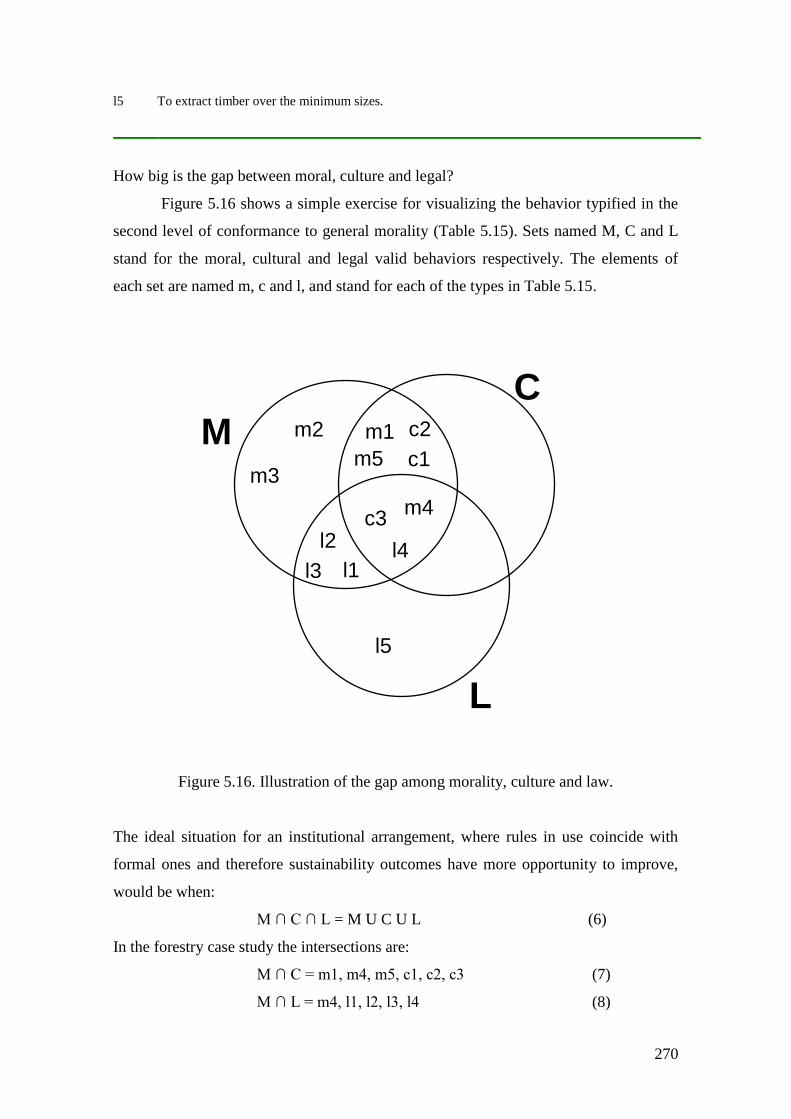
270
l5 To extract timber over the minimum sizes.
How big is the gap between moral, culture and legal?
Figure 5.16 shows a simple exercise for visualizing the behavior typified in the
second level of conformance to general morality (Table 5.15). Sets named M, C and L
stand for the moral, cultural and legal valid behaviors respectively. The elements of
each set are named m, c and l, and stand for each of the types in Table 5.15.
Figure 5.16. Illustration of the gap among morality, culture and law.
The ideal situation for an institutional arrangement, where rules in use coincide with
formal ones and therefore sustainability outcomes have more opportunity to improve,
would be when:
M ∩ C ∩ L = M U C U L (6)
In the forestry case study the intersections are:
M ∩ C = m1, m4, m5, c1, c2, c3 (7)
M ∩ L = m4, l1, l2, l3, l4 (8)
l3
m2
l1
l2 l4
c1
m3
m1 c2
C
M
L
m4 c3
m5
l5
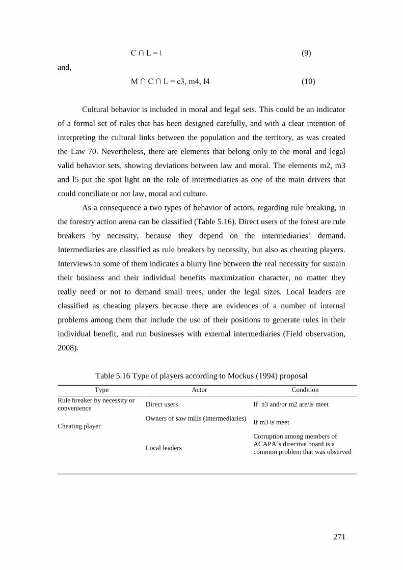
271
C ∩ L = (9)
and,
M ∩ C ∩ L = c3, m4, I4 (10)
Cultural behavior is included in moral and legal sets. This could be an indicator
of a formal set of rules that has been designed carefully, and with a clear intention of
interpreting the cultural links between the population and the territory, as was created
the Law 70. Nevertheless, there are elements that belong only to the moral and legal
valid behavior sets, showing deviations between law and moral. The elements m2, m3
and l5 put the spot light on the role of intermediaries as one of the main drivers that
could conciliate or not law, moral and culture.
As a consequence a two types of behavior of actors, regarding rule breaking, in
the forestry action arena can be classified (Table 5.16). Direct users of the forest are rule
breakers by necessity, because they depend on the intermediaries’ demand.
Intermediaries are classified as rule breakers by necessity, but also as cheating players.
Interviews to some of them indicates a blurry line between the real necessity for sustain
their business and their individual benefits maximization character, no matter they
really need or not to demand small trees, under the legal sizes. Local leaders are
classified as cheating players because there are evidences of a number of internal
problems among them that include the use of their positions to generate rules in their
individual benefit, and run businesses with external intermediaries (Field observation,
2008).
Table 5.16 Type of players according to Mockus (1994) proposal
Type Actor Condition
Rule breaker by necessity or
convenience Direct users If n3 and/or m2 are/is meet
Owners of saw mills (intermediaries)
If m3 is meet
Cheating player
Local leaders
Corruption among members of
ACAPA´s directive board is a
common problem that was observed
272
5.2.6 Summary of main findings of the forestry system’s institutional
analysis
I mentioned, in the last section of chapter 4 (Geographical and historical context), a set
of problems and potential shocks that entails the context of the forestry action arena and
institutional arrangements that I have discussed. (1) Illegal crops (coca) advancement,
lead by paramilitars and the subsequent conflict, and control of the territory. It implies a
modification of the formal and informal institutions that could affect the forest
management and ACAPA’s governance of the territory. This situation has influenced
the outcomes of the forestry action arena in terms of trust among members of the
community, and strategies of ACAPA´s leaders. The new generation of leaders has
adopted an adaptive strategy, which has undermined trust towards them, in addition to
the corruption accusations. (2) Incentivated by the national government, the
implementation of agro industries and monoculture (African Palm plantation projects)
by national and international capitals. As Restrepo (2010) and others have pointed, the
objective of the current Colombian government is to impose a modern project in the
region, which has been delayed for about one century. The way to achieve this goal has
focused on these agro industries that have not been completely unlinked from the illegal
armed groups incursion in the region. These two factors have changed the labor
relations and people´s relation with the monetary incentives of the action situation. The
access to fast an easy money brought by the illegal agricultural products, as well as the
pressure from agro industries in the sense of offer stable low income jobs has changed
the incentives. The consequence in the outcomes is the decrease in cooperation levels,
among local inhabitants and the high dependency of the intermediaries to guarantee
household income (the disappearing of informal institutions such as “mano de vuelta”
and the “minga” is an indicator). Elements of the moral valid behavior (Figure 5.16)
that are not included in the sets of cultural and legal valid behavior have their origin in
these situations.
And the third point mentioned in chapter 4 is that the territorial-ethnic-
environmental discourse of local activists does not reflect the daily life practices of the
population, in terms of the pretended ancestral communitarian use of the land. This fact
leads to conflicts among leaders of ACAPA, which difficult an effective process of
institutional arrangements crafting. This is the partial cause of the deviation of some
elements of the culture and moral sets (C and M from figure 5.16) from the legal valid
behavior. This point constitutes an important factor affecting the institutions in the
273
utilization of the forest and could be an indicator of the distance between mental models
of inhabitants of ACAPA and the formal property regime regarding the territory. The
consequence is that the rights on extracting and selling timber are not completely clear.
This dynamics gives clues about the problem in this action situation: weakly enforced
rights, recent history of new property regimes and weak state institutions.
274
5.3 The Water Use System
5.3.1 Outcomes of the irrigation experimental action situation
Next I will discuss the outcomes generated by the interactions in the three action
situations described above. As in the case of fisheries and forestry cases I orient the
discussion towards cooperation, trust and morality as the fundamental outcomes that
shape dynamics of the SES.
The experimental action situation
The Nash equilibrium of the game is produced when any of the players invest in the
public provision of water units, receiving 10 tokens each one generating a collective
payoff for the group of 50 tokens in each round. The other reference scenario is the
social optimum or the cooperative solution occurs when each player invest, in each
round, 10 tokens in the public good, producing a total amount of water of 100 units.
When extracting units of water each individual would take 20 units, therefore in 10
rounds each player would earn 200 tokens and the collective earnings would be 1000
tokens (Juan Camilo Cardenas et al., in press). In the second part of the experiment
players were asked to vote for any of the rules explained above to be implemented for
the next 10 rounds, but the rest of the mechanics of the game continued as in the first 10
rounds.
The first outcome to evaluate is the contribution of participants to the public
good, which is illustrated in figures 5.17 and 5.18. During the first part of the
experiment players start to contribute around 25 tokens in average, which represents the
50% of the cooperative equilibrium. During the next rounds contributions tend to
decrease, and at the end of this experimental stage, round ten, the average group
contribution is around 36% of the cooperative outcome (Figure 5.17a). At individual
scale (Figure 5.18a), players in upstream positions, A and B tend to contribute more
than the rest located downstream. The average of players B`s contribution is over the
50% of the cooperative equilibrium during the first ten rounds, and players A are
slightly under 50% of the social optimum. Players D and E reach the 40% of the
cooperative outcome while players C are below this percentage.
275
In the second stage of the experiment, the overall effect of elected rules (Figure
5.17b) is an important decrease of group contributions. The experimental sessions in
which participants elected to continue with the rotation rule (Figure 5.17c) group
contribution to public infrastructure decreased. In round 11 contributions started at 36%
of the social optimum, 14% less than round 1, in the first stage, and the average
finished, at round 20, at 32% of the cooperative equilibrium. With the quota rule (Figure
5.17d) the average decreasing pattern is less dramatic from round 11 to 17, but the last
rounds the mean contribution decreased strongly ending in the 28% of the cooperative
equilibrium.
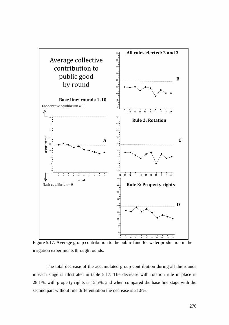
276
Figure 5.17. Average group contribution to the public fund for water production in the
irrigation experiments through rounds.
The total decrease of the accumulated group contribution during all the rounds
in each stage is illustrated in table 5.17. The decrease with rotation rule in place is
28.1%, with property rights is 15.5%, and when compared the base line stage with the
second part without rule differentiation the decrease is 21.8%.
Average collective contribution to
public good
by round
All rules elected: 2 and 3
Rule 2: Rotation
Rule 3: Property rights
Base line: rounds 1-10
A
B
C
D
Cooperative equilibrium = 50
Nash equilibrium= 0
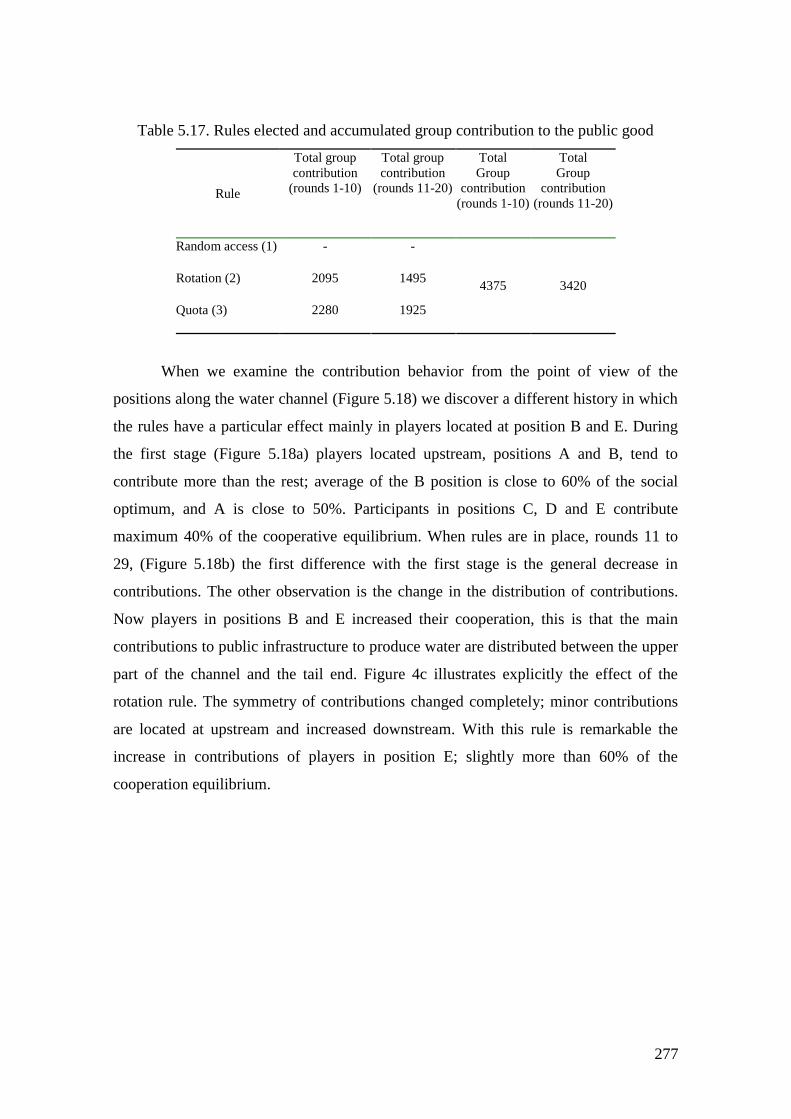
277
Table 5.17. Rules elected and accumulated group contribution to the public good
Rule
Total group
contribution
(rounds 1-10)
Total group
contribution
(rounds 11-20)
Total
Group
contribution
(rounds 1-10)
Total
Group
contribution
(rounds 11-20)
Random access (1)
- -
4375 3420 Rotation (2)
2095 1495
Quota (3)
2280 1925
When we examine the contribution behavior from the point of view of the
positions along the water channel (Figure 5.18) we discover a different history in which
the rules have a particular effect mainly in players located at position B and E. During
the first stage (Figure 5.18a) players located upstream, positions A and B, tend to
contribute more than the rest; average of the B position is close to 60% of the social
optimum, and A is close to 50%. Participants in positions C, D and E contribute
maximum 40% of the cooperative equilibrium. When rules are in place, rounds 11 to
29, (Figure 5.18b) the first difference with the first stage is the general decrease in
contributions. The other observation is the change in the distribution of contributions.
Now players in positions B and E increased their cooperation, this is that the main
contributions to public infrastructure to produce water are distributed between the upper
part of the channel and the tail end. Figure 4c illustrates explicitly the effect of the
rotation rule. The symmetry of contributions changed completely; minor contributions
are located at upstream and increased downstream. With this rule is remarkable the
increase in contributions of players in position E; slightly more than 60% of the
cooperation equilibrium.
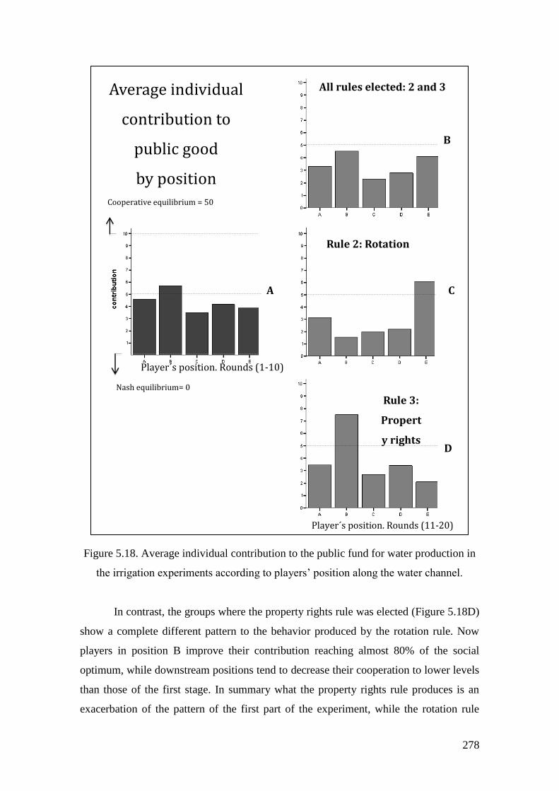
278
Figure 5.18. Average individual contribution to the public fund for water production in
the irrigation experiments according to players’ position along the water channel.
In contrast, the groups where the property rights rule was elected (Figure 5.18D)
show a complete different pattern to the behavior produced by the rotation rule. Now
players in position B improve their contribution reaching almost 80% of the social
optimum, while downstream positions tend to decrease their cooperation to lower levels
than those of the first stage. In summary what the property rights rule produces is an
exacerbation of the pattern of the first part of the experiment, while the rotation rule
Average individual
contribution to
public good
by position
All rules elected: 2 and 3
Rule 2: Rotation
Rule 3:
Propert
y rights
Player´s position. Rounds (1-10)
Player´s position. Rounds (11-20)
Cooperative equilibrium = 50
Nash equilibrium= 0
A
B
C
D
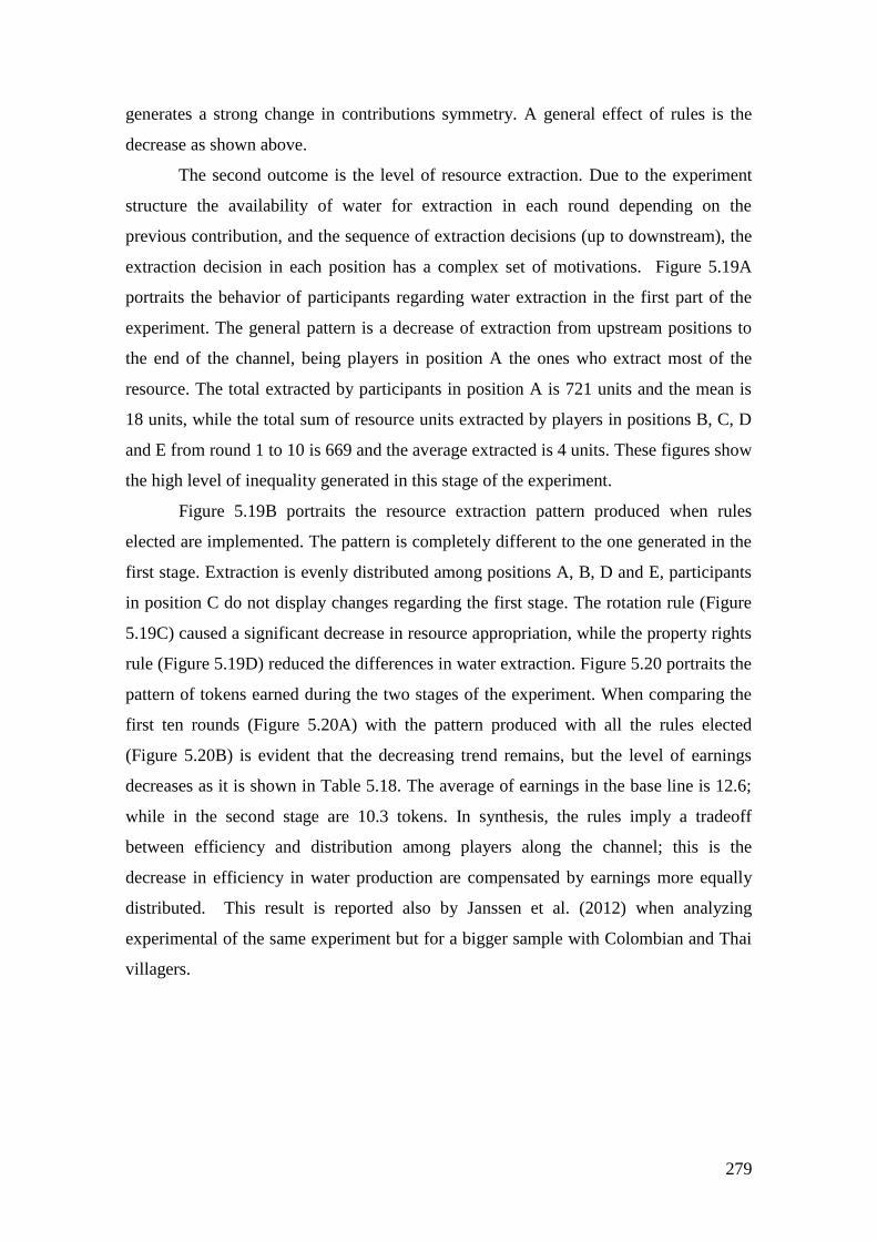
279
generates a strong change in contributions symmetry. A general effect of rules is the
decrease as shown above.
The second outcome is the level of resource extraction. Due to the experiment
structure the availability of water for extraction in each round depending on the
previous contribution, and the sequence of extraction decisions (up to downstream), the
extraction decision in each position has a complex set of motivations. Figure 5.19A
portraits the behavior of participants regarding water extraction in the first part of the
experiment. The general pattern is a decrease of extraction from upstream positions to
the end of the channel, being players in position A the ones who extract most of the
resource. The total extracted by participants in position A is 721 units and the mean is
18 units, while the total sum of resource units extracted by players in positions B, C, D
and E from round 1 to 10 is 669 and the average extracted is 4 units. These figures show
the high level of inequality generated in this stage of the experiment.
Figure 5.19B portraits the resource extraction pattern produced when rules
elected are implemented. The pattern is completely different to the one generated in the
first stage. Extraction is evenly distributed among positions A, B, D and E, participants
in position C do not display changes regarding the first stage. The rotation rule (Figure
5.19C) caused a significant decrease in resource appropriation, while the property rights
rule (Figure 5.19D) reduced the differences in water extraction. Figure 5.20 portraits the
pattern of tokens earned during the two stages of the experiment. When comparing the
first ten rounds (Figure 5.20A) with the pattern produced with all the rules elected
(Figure 5.20B) is evident that the decreasing trend remains, but the level of earnings
decreases as it is shown in Table 5.18. The average of earnings in the base line is 12.6;
while in the second stage are 10.3 tokens. In synthesis, the rules imply a tradeoff
between efficiency and distribution among players along the channel; this is the
decrease in efficiency in water production are compensated by earnings more equally
distributed. This result is reported also by Janssen et al. (2012) when analyzing
experimental of the same experiment but for a bigger sample with Colombian and Thai
villagers.
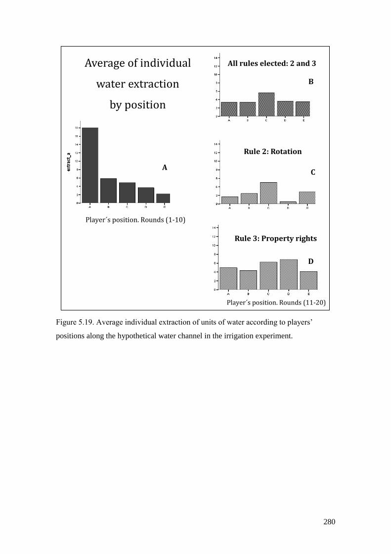
280
Figure 5.19. Average individual extraction of units of water according to players’
positions along the hypothetical water channel in the irrigation experiment.
Player´s position. Rounds (1-10)
All rules elected: 2 and 3
Rule 2: Rotation
Rule 3: Property rights
Player´s position. Rounds (11-20)
Average of individual
water extraction
by position
A
B
C
D
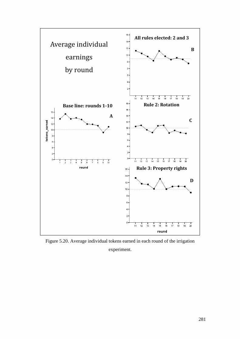
281
Figure 5.20. Average individual tokens earned in each round of the irrigation
experiment.
Average individual
earnings
by round
All rules elected: 2 and 3
Rule 2: Rotation
Rule 3: Property rights
Base line: rounds 1-10
A
B
C
D
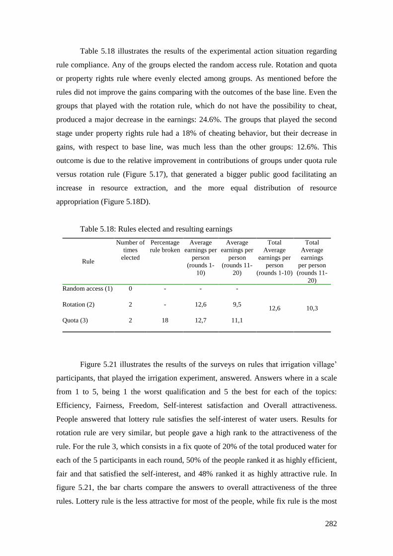
282
Table 5.18 illustrates the results of the experimental action situation regarding
rule compliance. Any of the groups elected the random access rule. Rotation and quota
or property rights rule where evenly elected among groups. As mentioned before the
rules did not improve the gains comparing with the outcomes of the base line. Even the
groups that played with the rotation rule, which do not have the possibility to cheat,
produced a major decrease in the earnings: 24.6%. The groups that played the second
stage under property rights rule had a 18% of cheating behavior, but their decrease in
gains, with respect to base line, was much less than the other groups: 12.6%. This
outcome is due to the relative improvement in contributions of groups under quota rule
versus rotation rule (Figure 5.17), that generated a bigger public good facilitating an
increase in resource extraction, and the more equal distribution of resource
appropriation (Figure 5.18D).
Table 5.18: Rules elected and resulting earnings
Rule
Number of
times
elected
Percentage
rule broken
Average
earnings per
person
(rounds 1-
10)
Average
earnings per
person
(rounds 11-
20)
Total
Average
earnings per
person
(rounds 1-10)
Total
Average
earnings
per person
(rounds 11-
20)
Random access (1)
0 - - -
12,6 10,3 Rotation (2)
2 - 12,6 9,5
Quota (3)
2 18 12,7 11,1
Figure 5.21 illustrates the results of the surveys on rules that irrigation village’
participants, that played the irrigation experiment, answered. Answers where in a scale
from 1 to 5, being 1 the worst qualification and 5 the best for each of the topics:
Efficiency, Fairness, Freedom, Self-interest satisfaction and Overall attractiveness.
People answered that lottery rule satisfies the self-interest of water users. Results for
rotation rule are very similar, but people gave a high rank to the attractiveness of the
rule. For the rule 3, which consists in a fix quote of 20% of the total produced water for
each of the 5 participants in each round, 50% of the people ranked it as highly efficient,
fair and that satisfied the self-interest, and 48% ranked it as highly attractive rule. In
figure 5.21, the bar charts compare the answers to overall attractiveness of the three
rules. Lottery rule is the less attractive for most of the people, while fix rule is the most
283
attractive, and rotation rule is also attractive but with lower percentages of answers in
ranking 5.
As I already mentioned, the aqueduct “El Granadillo” works based on rules
where the rotation scheme is present among the different “veredas” and the fix quota,
which is not an explicit rule. From interviews, it is clear that the conduct of people that
take more water, stoking in tanks or ponds is one of the more morally sanctioned
behavior; in fact, there is an explicit rule that prohibits water stoking. In the speeches of
most of the interviewees is the idea that people must be careful with water use and make
a rational use of the resource.
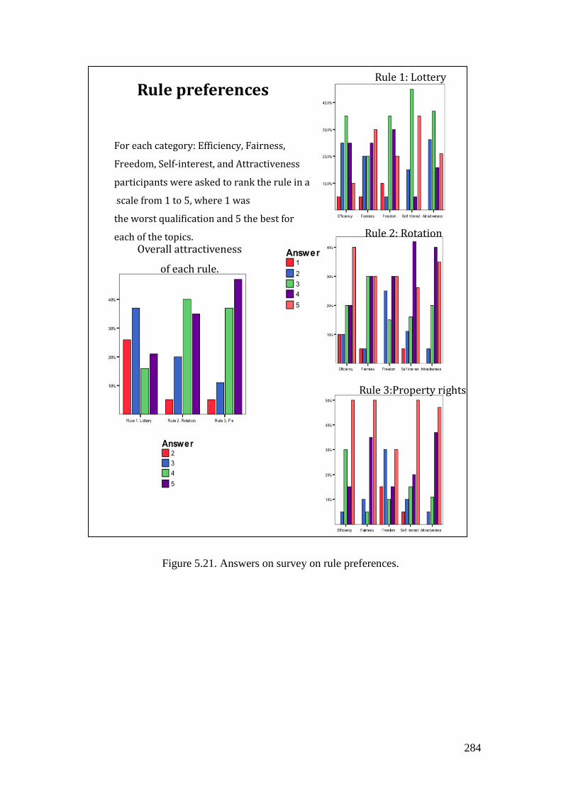
284
Figure 5.21. Answers on survey on rule preferences.
Rule 3:Property rights
Rule 2: Rotation
Rule 1: Lottery
Rule preferences
Overall attractiveness
of each rule.
For each category: Efficiency, Fairness,
Freedom, Self-interest, and Attractiveness
participants were asked to rank the rule in a
scale from 1 to 5, where 1 was
the worst qualification and 5 the best for
each of the topics.
285
5.3.2 Towards a more complex action arena: Collective construction of the
water RPG
With the experimental setting as a departure point just like in the other two cases, a
group of 20 participants attended to a workshop in order to improve the game. The most
relevant contribution from participants was the modification of the physical setting of
the experiments and the introduction of an explicit zone representing the water source.
The purpose of the game
The discussion about the reasons to build a role game was around individualism
and cooperation in the community. The generalized opinion was that people in the
community is quite selfish. Participants did not point this characteristic in direct relation
with water use or aqueduct problems, they referred to all aspects of the life. It is
important to note that people that attended to the workshop were only from the upper
veredas. They recognized that they are selfish and the waste of water is a common
behavior. Therefore, the objective of the game was set as: “to facilitate learning on
water distribution and cooperation for people from the community.”
The spatial representation
The smallest formal political and administrative unit in Colombian rural areas is
the Municipality, but in practice, the spatial unit with real meaning to people is the
vereda. The vereda is a region of variable size where rural human settlements, clustered
or disperse, have organized since colonial or even pre Hispanic times in some regions.
Usually there is one rural school in each vereda and inhabitants are organizationally
gathered in a communal entity called Community Action Council (Junta de Acción
Comunal, JAC), which is in charge of the management and lobbing for local
development projects. In this case study the most important geographic unit is the
vereda. The aqueduct system studied covers six veredas, and the participants in the
workshop used this entity as the fundamental spatial unit.
The participants replaced the individual plots of the experiment for the territory
of the veredas, grouping the 6 veredas in four, located according to their position in the
watershed. The second change consisted in the inclusion of a special zone for water
production in the uppermost part of the watershed, which represented a forest. An
important element of the structure of the game was, at least initially, that the plumber as
a character that was represented in a motorcycle and with capacity to move through out
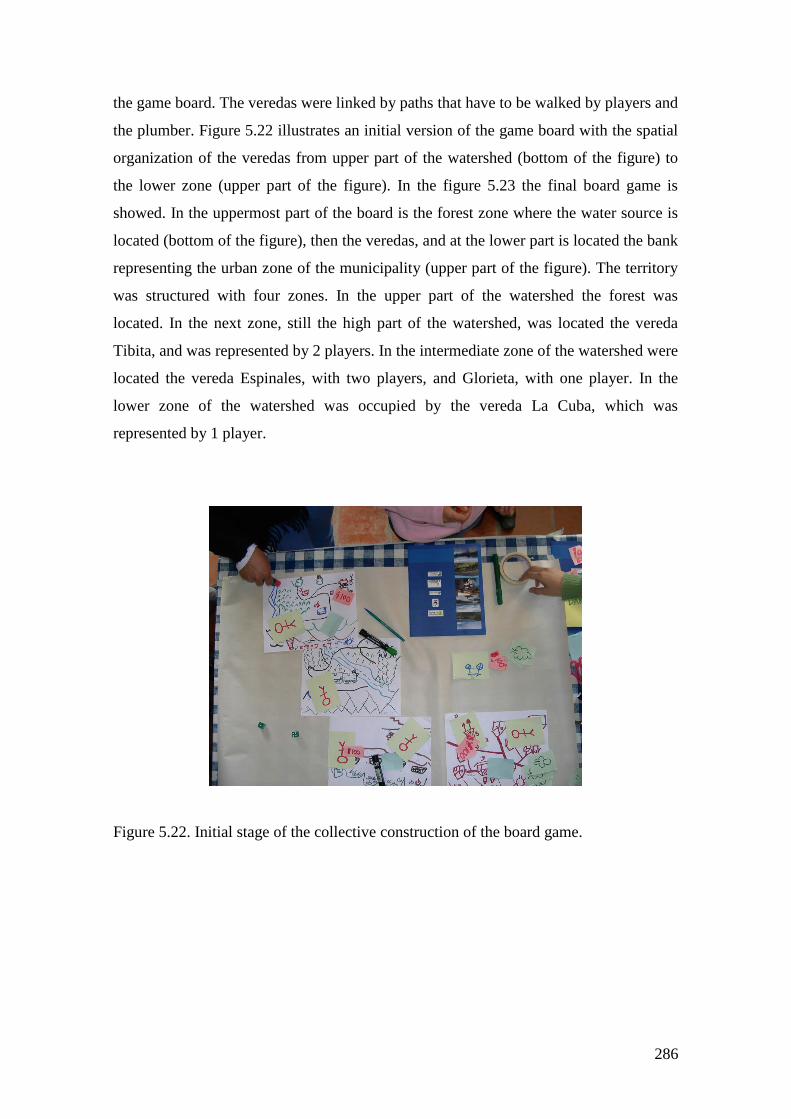
286
the game board. The veredas were linked by paths that have to be walked by players and
the plumber. Figure 5.22 illustrates an initial version of the game board with the spatial
organization of the veredas from upper part of the watershed (bottom of the figure) to
the lower zone (upper part of the figure). In the figure 5.23 the final board game is
showed. In the uppermost part of the board is the forest zone where the water source is
located (bottom of the figure), then the veredas, and at the lower part is located the bank
representing the urban zone of the municipality (upper part of the figure). The territory
was structured with four zones. In the upper part of the watershed the forest was
located. In the next zone, still the high part of the watershed, was located the vereda
Tibita, and was represented by 2 players. In the intermediate zone of the watershed were
located the vereda Espinales, with two players, and Glorieta, with one player. In the
lower zone of the watershed was occupied by the vereda La Cuba, which was
represented by 1 player.
Figure 5.22. Initial stage of the collective construction of the board game.
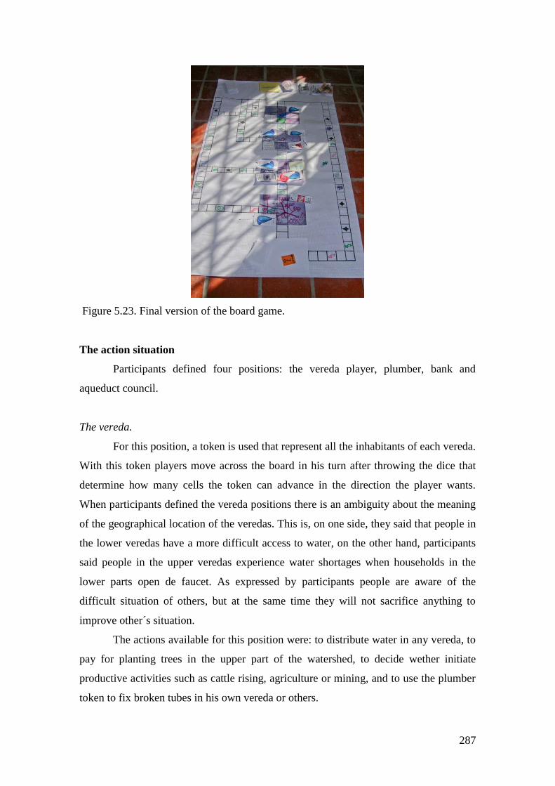
287
Figure 5.23. Final version of the board game.
The action situation
Participants defined four positions: the vereda player, plumber, bank and
aqueduct council.
The vereda.
For this position, a token is used that represent all the inhabitants of each vereda.
With this token players move across the board in his turn after throwing the dice that
determine how many cells the token can advance in the direction the player wants.
When participants defined the vereda positions there is an ambiguity about the meaning
of the geographical location of the veredas. This is, on one side, they said that people in
the lower veredas have a more difficult access to water, on the other hand, participants
said people in the upper veredas experience water shortages when households in the
lower parts open de faucet. As expressed by participants people are aware of the
difficult situation of others, but at the same time they will not sacrifice anything to
improve other´s situation.
The actions available for this position were: to distribute water in any vereda, to
pay for planting trees in the upper part of the watershed, to decide wether initiate
productive activities such as cattle rising, agriculture or mining, and to use the plumber
token to fix broken tubes in his own vereda or others.
288
The plumber.
The plumber is in charged of fix problems with the tubes in each vereda.
Damages in the aqueduct can happen when a player, in his turn, and after throwing the
dices, advances through out the board reaches a cell in which he has to withdraw a card
that could imply a broken tube. There are other cards that say that the player must pay
$1000 COP to the plumber, this payment goes directly to the aqueduct council. There is
another card that enables players to send the plumber to any vereda and fix problems
according to players’ will.
The bank.
Economic transaction in the water management is relevant, therefore in the role
game it was necessary a position that regulates monetary earnings. Participants
introduced early in the workshop monetary incentives. This fact is an important
indication of the main drivers of water management; to conserve the common recourse,
it must produce economic benefits. Therefore there is a tendency to perceive the water
as a common resource that is worth wile to conserve only if it produces monetary
benefits. The actions of the bank included to sell trees for planting in the upper end of
the watershed and lend money to participants.
Aqueduct council
The function of the council, in the RPG arena was to solve all the problems of
the aqueduct and to invest in improvements, but the council did not do anything, the
only role is to receive money from the community. One of the participants in the final
debriefing of the RPG expressed his vision of the council: “the aqueduct council only
receives money, and they steal it”. This is probably the expression of the low level of
trust in the public organizations. It is important to remark that this perception does not
mean that the aqueduct has not improve the well being of the community, it is reflecting
the cultural behavior that characterizes the people from this zone: they take advantage
of the benefits, but they do not accept the necessity of paying some costs. The
perception of inefficiency is reflected in the idea according that the cost they pay for the
aqueduct do not reflect benefits, the interpretation could be that they perceive costs
higher than benefits.
289
Information available to participants and control over outcomes
Participants are aware of their role regarding the production of water through the
management and conservation of highlands forests, vegetal cover (páramo) and springs.
This is expressed in the game: when a player plants a tree in the upper part, a volume of
water is produced. Information about the relation among water and production is clear
for all participants, but the production is the key part, and its conservation depends on
the water use. The low level of council’s participation in maintaining aqueduct’
structure seems to be a generalized perception among participants. This is reflected in
the relevance that participants give to the plumber, but on the other hand, often made
jokes about his inefficiency. Regarding the control over outcomes, the role game
structure allowed to each player to control water production and allocation, but there
was a source of uncertainty given by the dice players had to roll in order to advance in
the game board. Additionally, depending on the cards they receive players could affect
other´s players outcomes. The players wanted to control their interests for each round,
they seemed not to think in long term projects, they did not traced a strategy for the end
of the game.
Synthesis of the role game action situation collective construction
Table 5.19 illustrates a synthesis of the modifications that took place on the
economic experiments during the co-construction of the role game. The summary shows
the expected and actual changes that occurred in the collective construction of the role
game. The main change in the resource settings was the explicit representation of water
units in the role game. Players introduced the spatial context: they organized the board
game with an upper and lower part and the “veredas”, as well as a forest zone in the
upper part for water production. Individual decisions were modified for choosing
productive activities, buying trees to produce water, and the possibility to distribute
water among the veredas. The incentives structure was modified; in the role game the
payoffs are determined by the type of productive activities each player choose. Also the
objective of the players could be to distribute an equal quantity of water in the four
veredas of the game board. Participants did not design any rule for water management.
They included new roles in addition to the direct water users´ roles; the plumber, the
bank and users were divided in groups according their real belonging to the veredas.
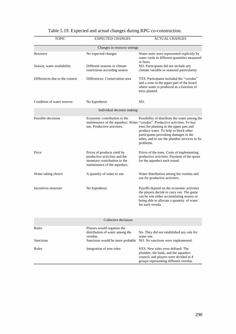
290
Table 5.19. Expected and actual changes during RPG co-construction.
TOPIC
EXPECTED CHANGES ACTUAL CHANGES
Changes in resource settings
Resource
No expected changes Water units were represented explicitly by
water cards in different quantities measured
in liters.
Season, water availability Different seasons or climate
restrictions according season
NO. Participants did not include any
climate variable or seasonal particularity
Differences due to the context Differences- Conservation area
YES. Participants included the “veredas”
and a zone in the upper part of the board
where water is produced as a function of
trees planted.
Condition of water sources
No hypothesis NO.
Individual decision making
Possible decisions Economic contribution to the
maintenance of the aqueduct. Water
use. Productive activities.
Possibility of distribute the water among the
“veredas”. Productive activities. To buy
trees for planting in the upper part and
produce water. To help or block other
participants provoking damages in the
tubes, and to use the plumber services to fix
problems.
Price Prices of products yield by
productive activities and the
monetary contribution to the
maintenance of the aqueduct.
Prices of the trees. Costs of implementing
productive activities. Payment of the quota
for the aqueduct each round.
Water taking choice A quantity of water to use. Water distribution among the veredas and
use for productive activities.
Incentives structure
No hypothesis Payoffs depend on the economic activities
the players decide to carry out. The game
can be win either accumulating money or
being able to allocate a quantity of water
for each vereda.
Collective decisions
Rules Players would organize the
distribution of water among the
veredas.
No. They did not established any rule for
water use.
Sanctions Sanctions would be more probable
NO. No sanctions were implemented.
Roles Integration of new roles YES. New roles were defined: The
plumber, the bank, and the aqueduct
council, and players were divided in 4
groups representing different veredas.
291
5.3.3 Outcomes of the water RPG action situation
As explained above the objective of the role game was to find better ways of water
distribution among people from the community. A player (vereda) could win the game
reaching any of these two goals: to accumulate 20 liters of water, to accumulate $40.000
COP. If collectively the veredas accumulate 100 liters of water, it is considered that the
game is won by all, meaning that the community has cooperated to maintain the
aqueduct and distribute the resource with equity.
The forest in the upper part of the board produces water for the veredas. When a
player plants 1 tree, it produces water only for the upper vereda (Tibita), if plants 2 then
generates water for Tibita and Espinales, if plants 3, the water reaches the vereda La
Glorieta, and if the number of trees planted is 4 then La Cuba receives water. Players
can plant trees that can be bought in the bank at $200 each. Water in the veredas can be
used to irrigation, domestic use and livestock, and each player can decide to implement
a productive activity (crop and/or livestock) for which he wins money, but also it needs
a certain amount of water to earn money. In each round each player must pay $100 to
the plumber in order to maintain the infrastructure and the provision of water. If a
player does not pay to the plumber in a given turn, the water is removed from the
corresponding vereda. Each player (vereda) starts the game with an endowment of
$8.500 COP. They can make any negotiation with other players. In each turn players
can move through the game board advancing a number of cells after throwing two dice,
and only can make actions when they are in the specific places. For example if they
want to purchase trees, they need to go until the bank cell in the lowest part of the
board, or if a player wants to plant a tree or distribute water manually among veredas he
must move until the corresponding cell.
The outcomes of the game in terms of water distribution and accumulated gains
are illustrated in table 5.23. The veredas located in the upper part of the watershed
accumulated more water than the downstream ones. The vereda that accumulated more
money was La Cuba, located in the lowest part of the watershed, but they couldn’t
accumulate the amount needed to win ($40.000). The Aqueduct Council accumulated an
important quantity of money and they did not invest in maintenance of the aqueduct or
in water provision, this is planting trees in the forest in the uppermost part of the
watershed or any other type of negotiation with players trying to induce a better
distribution of water among players. The players accumulated money or water but
didn´t tried to make a balance. In two of the veredas players constructed water
292
reservoirs that implied that each player of the vereda had to give 10 liters of water and
the owner received $10.000. The consequence of this action was that the accumulation
of water for the vereda was more difficult but the owner could make profits.
Two insights arise from the interactions among participants during the game. On
one hand, the cooperation among participants to distribute water among veredas
depends directly on the economic benefits players could have from that. On the other
side, the role of the plumber wasn´t played by any person, instead, the character was
represented by a token in the game that could be used by the players to fix infrastructure
problems. Each time the plumber was needed participants made comments regarding his
inefficiency and made fun of him. The plumber was identified as the character that
better represented the behavior of the Aqueduct Council. This attitude is interpreted, as
the general attitude towards rules of people of the region because finally they do what
they think and this is better independently of the formal prescriptions. Also this
behavior with the plumber is the result of the idea that the one who cares about the
common resource is someone else different to the users.
Table 5.23. Results of the role game
Player Water
(Liters)
Money
(COP)
Glorieta
55
1.000
Tibita
40 0
Espinales 25 0
La Cuba 15 29.000
Aqueduct Council
- 21.000
5.3.4 Institutional arrangements in the water SES
Formal rules
Tables 5.20 and 5.21 illustrate the formal rules classified according to ADICO rule
building blocks, and their AIM. Table 5.20 shows a set of rules at national scale, which
aim focus on the conservation of the resource, the declaration of water access as a
fundamental right of people, and the inclusion of water use in the planning at regional
293
and municipal scales. The deontic of rules is quite general and involves public instances
such as municipalities and the State in general. These prescriptions are classified as
rules because they mention sanctions, but without identifying and specifying them. The
second group of rules is the regulation of the aqueduct council. The attribute of these
rules is constrained to the users of the aqueduct. This regulation focuses in the definition
of prescriptions for the aqueduct operation, duties and rights of the users, maintenance
and subscription fees, and the positions and possible actions of users and aqueduct
council members.
According to the AIM of the rules, Table 5.21 shows the type of each rule in
terms of the part of the action situation it is affecting. Rules at National scale are scope
rules, they attempt to guarantee the outcomes in terms of water conservation, access and
resource use planning. The aqueduct association regulation gives prescription that affect
all the components of the local action situation. Three prescriptions are position rules
defining the actions that must take the participants occupying a given position focused
on maintenance, watershed protection, rights and duties of users and monitoring. Two
of the prescriptions are boundary rules that define who are the users and household
enter or exit conditions to the system. Two prescriptions are choice rules that specify the
actions of participants. Aggregation rules define how to control the link between actions
and outcomes, establishing the mechanisms for monitoring water use and connect new
users to the system. The prescription about monitoring affects the information that users
and the council have about water use, therefore this is a information rule. The statutes of
the aqueduct association include a set of prescriptions that define the prohibitions and
system of sanctions for the aqueduct’ users.
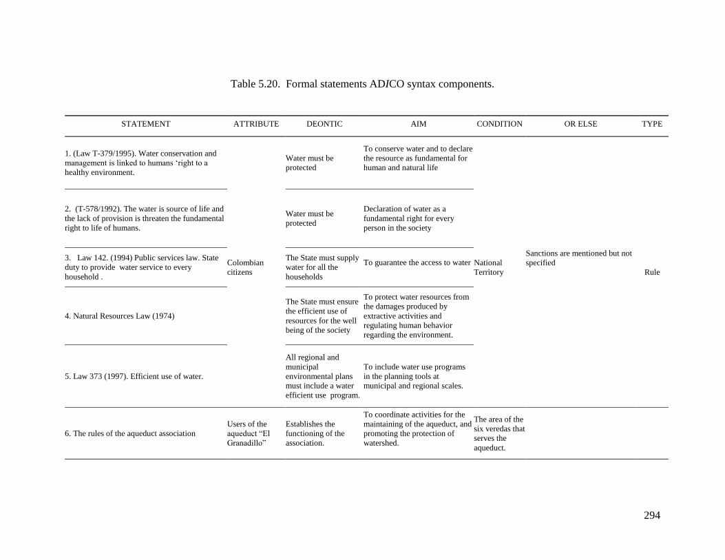
294
Table 5.20. Formal statements ADICO syntax components.
STATEMENT ATTRIBUTE DEONTIC AIM CONDITION OR ELSE TYPE
1. (Law T-379/1995). Water conservation and
management is linked to humans ‘right to a
healthy environment.
Colombian
citizens
Water must be
protected
To conserve water and to declare
the resource as fundamental for
human and natural life
National
Territory
Sanctions are mentioned but not
specified
Rule
2. (T-578/1992). The water is source of life and
the lack of provision is threaten the fundamental
right to life of humans.
Water must be
protected
Declaration of water as a
fundamental right for every
person in the society
3. Law 142. (1994) Public services law. State
duty to provide water service to every
household .
The State must supply
water for all the
households
To guarantee the access to water
4. Natural Resources Law (1974)
The State must ensure
the efficient use of
resources for the well
being of the society
To protect water resources from
the damages produced by
extractive activities and
regulating human behavior
regarding the environment.
5. Law 373 (1997). Efficient use of water.
All regional and
municipal
environmental plans
must include a water
efficient use program.
To include water use programs
in the planning tools at
municipal and regional scales.
6. The rules of the aqueduct association
Users of the
aqueduct “El
Granadillo”
Establishes the
functioning of the
association.
To coordinate activities for the
maintaining of the aqueduct, and
promoting the protection of
watershed.
The area of the
six veredas that
serves the
aqueduct.
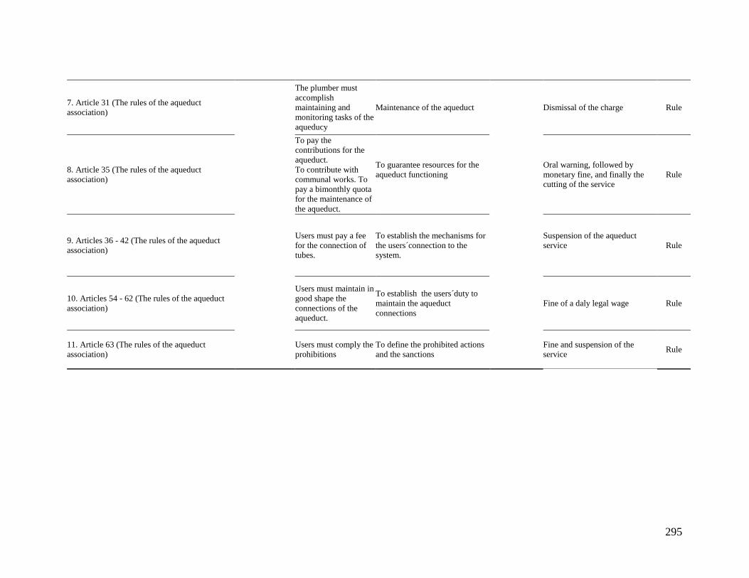
295
7. Article 31 (The rules of the aqueduct
association)
The plumber must
accomplish
maintaining and
monitoring tasks of the
aqueducy
Maintenance of the aqueduct Dismissal of the charge Rule
8. Article 35 (The rules of the aqueduct
association)
To pay the
contributions for the
aqueduct.
To contribute with
communal works. To
pay a bimonthly quota
for the maintenance of
the aqueduct.
To guarantee resources for the
aqueduct functioning
Oral warning, followed by
monetary fine, and finally the
cutting of the service
Rule
9. Articles 36 - 42 (The rules of the aqueduct
association)
Users must pay a fee
for the connection of
tubes.
To establish the mechanisms for
the users´connection to the
system.
Suspension of the aqueduct
service
Rule
10. Articles 54 - 62 (The rules of the aqueduct
association)
Users must maintain in
good shape the
connections of the
aqueduct.
To establish the users´duty to
maintain the aqueduct
connections
Fine of a daly legal wage Rule
11. Article 63 (The rules of the aqueduct
association)
Users must comply the
prohibitions
To define the prohibited actions
and the sanctions
Fine and suspension of the
service Rule
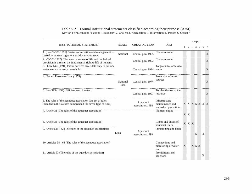
296
Table 5.21. Formal institutional statements classified according their purpose (AIM) Key for TYPE column: Position: 1, Boundary: 2, Choice: 3, Aggregation: 4, Information: 5, Payoff: 6, Scope: 7
INSTITUTIONAL STATEMENT SCALE CREATOR/YEAR AIM TYPE
1 2 3 4 5 6 7
1. (Law T-379/1995). Water conservation and management is
linked to humans´right to a healthy environment. National Central gov/ 1995
Conserve water
X
2. (T-578/1992). The water is source of life and the lack of
provision is threaten the fundamental right to life of humans.
National
Local
Central gov/ 1992 Conserve water
X
3. Law 142. (1994) Public services law. State duty to provide
water service to every household . Central gov/ 1994
To guarantee access to
water X
4. Natural Resources Law (1974)
Central gov/ 1974
Protection of water
sources X
5. Law 373 (1997). Efficient use of water.
Central gov/ 1997
To plan the use of the
resource X
6. The rules of the aqueduct association (the set of rules
included in the statutes comprehend the seven type of rules) Aqueduct
association/1993
Infrastructure
maintainance and
watershed protection.
X X X X X X X
7. Article 31 (The rules of the aqueduct association)
Local
Aqueduct
association/1993
Plumber duties
X X
8. Article 35 (The rules of the aqueduct association) Rights and duties of
aqueduct users X X X
9. Articles 36 - 42 (The rules of the aqueduct association) Functioning and costs
X X
10. Articles 54 - 62 (The rules of the aqueduct association) Connections and
monitoring of water
use
X X X X
11. Article 63 (The rules of the aqueduct association) Prohibitions and
sanctions X
297
Operational Rules
Operational rules in the aqueduct system are inferred from interviews and surveys. A first
observation is that all the interviewees recognized most of the formal rules of the aqueduct.
In this section I summarize the rules they recognized and express that users comply.
The use of water is constrained to households. Irrigation utilization is not permitted,
because the type of crops and climate conditions, historically have been managed with the
rain. According interviewees when summer is strong they can use water from the aqueduct
for livestock. The number of pipes that can be attached to the main tube per user is limited.
Accumulation of water from the tubes cannot be stocked in artificial ponds or tanks. Users
have to pay a maintenance fee each two months. There is a rotation scheme among
“veredas”, each two days the water is released to different “veredas”.
Persons do not know the aqueduct council formal statutes; they have the perception
that this is “a complicated issue that nobody understands”. One of the interviewees was the
president of the aqueduct council; he said that everybody knows the statutes. Formal rules
in use in the aqueduct “El Granadillo” seem to be recognized by all the interviewees. The
plumber said that there are no clear rules, but that the only sure thing is that he must control
that people do not waste water, using it for irrigation or ponds. As we already mentioned
before, the aqueduct “El Granadillo” works based on rules where the rotation scheme is
present among the different “veredas” and the fix quota, which is not an explicit rule. From
interviews, it is clear that the behavior of people that take more water, stoking in tanks or
ponds is one of the more morally sanctioned behavior; in fact, there is an explicit rule that
prohibits water stoking. In the speeches of most of the interviewees is the idea that people
must be careful with water use and make a rational use of the resource.
Rule compliance
One of the three women interviewed talks about rule compliance in term of how
things must be. She says, if she would be the president of the Aqueduct Council, she would
make sure “that the aqueduct would be equal for everybody”, not the way it works today,
according her; the rich people get more water than poor people. She illustrated this situation
with an example of one of the neighbors, giving the real names of the persons involved in
298
the situation. The same woman said that when someone breaks the rules nobody speaks,
they act as if nothing would have happened. She says, people act in this way to avoid
problems and having enemies. In contrast with this testimony, the plumber of the aqueduct
said that everybody comply the rules, even in summer months. Though his idea of
trustworthiness in this community is extremely low, he gave a vision of the aqueduct as a
system where everything works almost perfect. Regarding this topic, the president of the
aqueduct council said that sometimes people break rules, and that they do not apply strictly
the sanctions written in the statutes, he said, “we try to fix the problem talking with people
before apply the sanctions”. He said that sometimes it is necessary to call the “personero”
of the municipality to make a person to stick to the rules. Clearly they try to applied,
informally, the principle of graduated sanctions, the formal rule of the aqueduct regarding
rule breaking, is to impose a fine or cutting water supply, instead they call the attention of
the offender, first verbal, second they apply a fine, and third the service is suspended. The
president says that these sanctions are rarely implemented; they prefer to talk with people
first. This was confirmed by the plumber.
The purpose of the rules
Operative rules affect directly the action situation in which aqueduct users are immerse on
daily basis. The AIM of the rules in use indicates the elements of the action situation they
are regulating, and in turn, the behavior of participants. Five rules (7-11 in tables 5.21 and
5.22) types of operational rules are key means of structuring the interactions for aqueduct
users in reaching successful outcomes in water allocation. These are position, boundary,
choice, aggregation, information and payoff type of rules classified according their
objective.
Position rules: There are three main local positions: aqueduct users (households), the
plumber in charge of aqueduct maintenance and monitoring, and the president of the
aqueduct council. There are two positions that are external to the aqueduct system but they
have influence on the aqueduct. The first is the regional environmental authority45 that
formally has the function of protecting water sources, to control de management of
45 Corporación Autonoma Regional de Cundinamarca (CAR)

299
watersheds, and issuing water rights to rural local aqueducts. In the case study, and in
practice, the agency visits the zone, in average twice a year, and gathers part of the
community for planting trees in the upper part of the basing in order to protect water
sources. The other position has to do with the technical advice and monitoring of water
quality. The municipality fills this position. Usually this function is carried out after
political lobbying from the aqueduct council president.
Boundary rules. In this case the operative rules that define who are in the system coincide
with the formal prescription of the aqueduct rules. There are three boundary requirements:
1. Membership: Users of the aqueduct have to be part of the aqueduct organization
2. Fee: Payment of an entry fee is necessary to be member of the aqueduct.
3. Geographical: The household must be located in one of the six “veredas” covered
by the aqueduct.
Choice rules: These types of rules define the structure of the resource allocation. They
define the actions that appropriators can carry out in terms of space, time and technological
capabilities. Therefore in the system being analyzed the operational rules of this type are
the following:
1. Time: There is a rotation rule for the different “veredas” in water supply. Only in
summer season people can use it for livestock.
2. Space: The use of water is constrained to the households. Irrigation of crops is not
permitted with water from the aqueduct. The number of tubes for each household is
limited. Moreover there is a fixed quantity of water for each household.
3. Technology: Water cannot be stocked in reservoirs.
Information rules: When somebody breaks the rules nobody talks about that. Twice per
year the general assembly of the aqueduct, which is composed by all users, gathers and
delivers a report on the organization activities, problems and changes in the aqueduct
council.
Payoff rules. Two types of rules that affect the costs and benefits of the action situation are
present in the aqueduct system: maintenance and sanctions. People must pay a maintenance
fee every two months. Sanctions are graduated; the rule breakers are first addressed orally,
next time they have to pay a fine, and finally if they break the rule for third time the
aqueduct service is suspended.
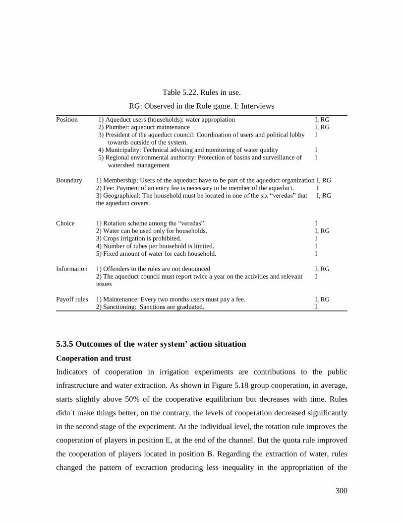
300
Table 5.22. Rules in use.
RG: Observed in the Role game. I: Interviews
Position 1) Aqueduct users (households): water appropiation
2) Plumber: aqueduct maintenance
3) President of the aqueduct council: Coordination of users and political lobby
towards outside of the system.
4) Municipality: Technical advising and monitoring of water quality
5) Regional environmental authority: Protection of basins and surveillance of
watershed management
I, RG
I, RG
I
I
I
Boundary 1) Membership: Users of the aqueduct have to be part of the aqueduct organization
2) Fee: Payment of an entry fee is necessary to be member of the aqueduct.
3) Geographical: The household must be located in one of the six “veredas” that
the aqueduct covers.
I, RG
I
I, RG
Choice 1) Rotation scheme among the “veredas”.
2) Water can be used only for households.
3) Crops irrigation is prohibited.
4) Number of tubes per household is limited.
5) Fixed amount of water for each household.
I
I, RG
I
I
I
Information
1) Offenders to the rules are not denounced
2) The aqueduct council must report twice a year on the activities and relevant
issues
I, RG
I
Payoff rules
1) Maintenance: Every two months users must pay a fee.
2) Sanctioning: Sanctions are graduated.
I, RG
I
5.3.5 Outcomes of the water system’ action situation
Cooperation and trust
Indicators of cooperation in irrigation experiments are contributions to the public
infrastructure and water extraction. As shown in Figure 5.18 group cooperation, in average,
starts slightly above 50% of the cooperative equilibrium but decreases with time. Rules
didn´t make things better, on the contrary, the levels of cooperation decreased significantly
in the second stage of the experiment. At the individual level, the rotation rule improves the
cooperation of players in position E, at the end of the channel. But the quota rule improved
the cooperation of players located in position B. Regarding the extraction of water, rules
changed the pattern of extraction producing less inequality in the appropriation of the
301
resource (Figure 5.19). During the first rounds of the base line, the levels of trust in others
explain the average group contributions. But as rounds passed, inequalities in extraction
eroded trust in the group leading to lessen the contributions. When rules were implemented
the extraction was redistributed but the behavior of contributions followed the same trend,
meaning that levels of trust decreased through the rounds.
The surveys showed a low level of trust among the community: 0,53 compared to
fishery village: 0.73, and forestry village: 0.63. The findings of the interviews could help to
explain the results of the survey regarding low levels of trust in the irrigation village. A
recent regulation from the Colombian Public Water Policy, demands that all rural
communitarian aqueducts must become a commercial enterprise or a legal cooperative. If
this condition is not meet the government will be in charge of the aqueduct administration.
The interpretation of the community is that the intention of government is the privatization
of water supply, with the consequent increase in prices and a water supply schema similar
to urban areas. The Aqueduct Council is trying to face this situation by adjusting the
statutes of the aqueduct to become a cooperative. As a consequence, in words of the
Aqueduct Council’s president, “people don’t want more workshops, researchers and
external projects in the zone, because they don’t help, they just take what they need”. This
situation contributes to reinforce the low levels of trust from community towards outside
actors and governmental regulators.
An initial hypothesis to the current institutional setting dynamics, in the irrigation site,
could be an action arena resulting of the combination of the following factors: 1) lack of
coordination between formal Colombian institutional arrangements at national, regional and
local scales. 2) The dominant agenda that feed policies at national scale is the liberalization
and privatization solutions, and clearly, it is influencing local scales. 3) Information about
local contexts does not flow towards national scale, and possibly interests at each scale are
different. There is no dialogue among governmental agencies, at national scale, in charge of
policies for the use and conservation of different resources. Policies are punctual and try to
address problems very specifically instead of integral approaches. 4) At local scale, trust
levels are extremely weak. 5) Trust in governmental institutions is low, but also trust, from
the state, in the capacity of local communities to manage by themselves their resources is
low. Then, in order to cope with an imposed institutional system, local organizations try to

302
defend their local institutions and their resource management way, by doing poor and
shortsighted adaptations.
This scenario produces low levels of cooperation reinforced by the low levels of
trust among members of the community and across scales of water management system’s
governance. Therefore, local participants of the action arena close the doors to external
actors as a reaction to the possibility of losing their property rights over water and
aqueduct. If the property rights are threatened the long term expectative and certainty is
compromised, therefore the action situation moves from a coordination game to a
prisoner’s dilemma. A possible interpretation of behavior in the second stage of
experiments is that participants saw the rules as a proxy of governmental agencies and the
level of rule compliance; 18% of rule breaking (Table 5.18) in property rights rule, is an
expression of this action situation’s equilibrium.
During the RPG, participants made jokes about the aqueduct council, making public
the low trust they feel in the council. The plumber was not used in the game, occasionally
players made fun of him, showing a direct identification his figure with the aqueduct
council. This position has a relevant symbolic value for users of the aqueduct because
during the RPG people attributed some characteristics such as inefficiency and negligence;
players forget his existence during the game. The organization that they create themselves
has a number of problems, which are represented in the plumber character.
From interviews it is possible to have a general picture about the levels of trust in
the community of the vereda Tibita Centro. Among the five interviewees there were two
persons that have arrived to the community seven years ago and the other three were born
in the place (natives). This fact allowed us to have two points of view regarding social
dynamics of the community. Natives tend to express their ideas about trustworthiness in
terms of water management. When it comes to the issue of controlling the amount of water
for each household, a woman, who lives in the upper part of the pipe, said that everybody is
responsible of paying its maintenance fee, and that people in general is aware about the
importance of fairness in water sharing. In contrast, the plumber of the aqueduct, said, on
one hand, that people in the six-monthly meeting of the aqueduct council usually ask about
money management, showing a lack of trust in the adequate use of the resources. On the
other hand he said that, in general, aqueduct’ users do not have many conflicts about
303
sharing water. When we asked if people trust in each other in this community, his answer
was clear: “One can’t trust even in one’s mother”.
The interviewees that have arrived to the place seven years ago expressed in a
straightforward manner their idea of low trustworthiness in the community. One of them
said: “each one look after of his own business … here one can’t trust in anybody, and you
can’t help anybody…here people is so selfish”. Interesting enough to be mentioned is the
fact that these persons talked about the reputation of the zone for having presence of
guerrillas some years ago. They left their home villages due to the lack of employment and
the worth of mouth said that in this vereda were more working opportunities, but it would
have to be careful due to the guerrilla issue. Regarding the aqueduct, a woman said that few
years ago she wanted to be president of the aqueduct council and she postulated her name
but she only got five votes from the four women present and her vote. She concludes: “in
this people zone is extremely “machista” (male chauvinist), they don’t trust in women for
the aqueduct management”.
Rules and general morality conformance
Context, history and institutional arrangements generate a particular action arena that, in
turn, produces a specific moral system. As in the previous cases, in this section I Table 5.24
illustrates the first and second level of morality conformance in the aqueduct´s action
situation
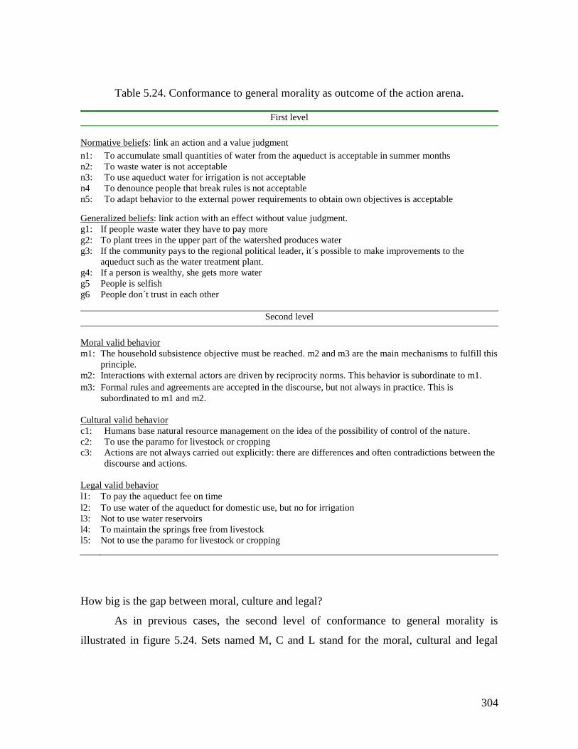
304
Table 5.24. Conformance to general morality as outcome of the action arena.
First level
Normative beliefs: link an action and a value judgment
n1: To accumulate small quantities of water from the aqueduct is acceptable in summer months
n2: To waste water is not acceptable
n3: To use aqueduct water for irrigation is not acceptable
n4 To denounce people that break rules is not acceptable
n5: To adapt behavior to the external power requirements to obtain own objectives is acceptable
Generalized beliefs: link action with an effect without value judgment.
g1: If people waste water they have to pay more
g2: To plant trees in the upper part of the watershed produces water
g3: If the community pays to the regional political leader, it´s possible to make improvements to the
aqueduct such as the water treatment plant.
g4: If a person is wealthy, she gets more water
g5 People is selfish
g6
People don´t trust in each other
Second level
Moral valid behavior
m1: The household subsistence objective must be reached. m2 and m3 are the main mechanisms to fulfill this
principle.
m2: Interactions with external actors are driven by reciprocity norms. This behavior is subordinate to m1.
m3: Formal rules and agreements are accepted in the discourse, but not always in practice. This is
subordinated to m1 and m2.
Cultural valid behavior
c1: Humans base natural resource management on the idea of the possibility of control of the nature.
c2: To use the paramo for livestock or cropping
c3: Actions are not always carried out explicitly: there are differences and often contradictions between the
discourse and actions.
Legal valid behavior
l1: To pay the aqueduct fee on time
l2: To use water of the aqueduct for domestic use, but no for irrigation
l3: Not to use water reservoirs
l4: To maintain the springs free from livestock
l5: Not to use the paramo for livestock or cropping
How big is the gap between moral, culture and legal?
As in previous cases, the second level of conformance to general morality is
illustrated in figure 5.24. Sets named M, C and L stand for the moral, cultural and legal
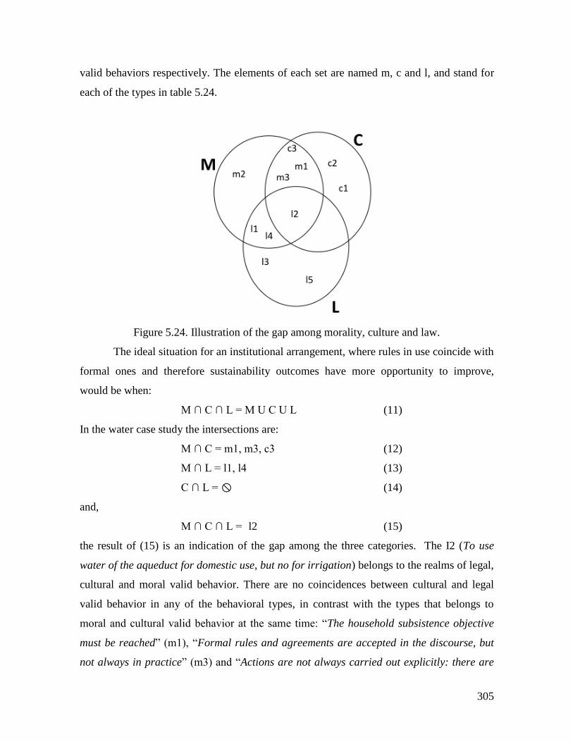
305
valid behaviors respectively. The elements of each set are named m, c and l, and stand for
each of the types in table 5.24.
Figure 5.24. Illustration of the gap among morality, culture and law.
The ideal situation for an institutional arrangement, where rules in use coincide with
formal ones and therefore sustainability outcomes have more opportunity to improve,
would be when:
M ∩ C ∩ L = M U C U L (11)
In the water case study the intersections are:
M ∩ C = m1, m3, c3 (12)
M ∩ L = l1, l4 (13)
C ∩ L = (14)
and,
M ∩ C ∩ L = l2 (15)
the result of (15) is an indication of the gap among the three categories. The I2 (To use
water of the aqueduct for domestic use, but no for irrigation) belongs to the realms of legal,
cultural and moral valid behavior. There are no coincidences between cultural and legal
valid behavior in any of the behavioral types, in contrast with the types that belongs to
moral and cultural valid behavior at the same time: “The household subsistence objective
must be reached” (m1), “Formal rules and agreements are accepted in the discourse, but
not always in practice” (m3) and “Actions are not always carried out explicitly: there are
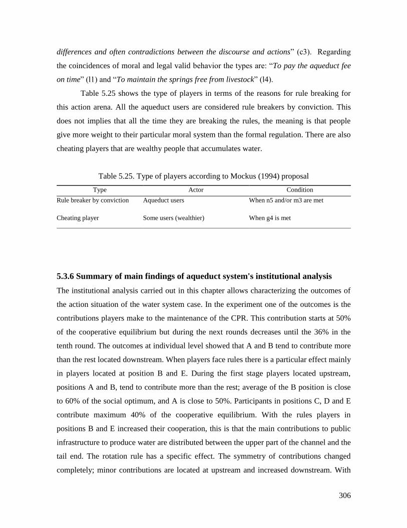
306
differences and often contradictions between the discourse and actions” (c3). Regarding
the coincidences of moral and legal valid behavior the types are: “To pay the aqueduct fee
on time” (l1) and “To maintain the springs free from livestock” (l4).
Table 5.25 shows the type of players in terms of the reasons for rule breaking for
this action arena. All the aqueduct users are considered rule breakers by conviction. This
does not implies that all the time they are breaking the rules, the meaning is that people
give more weight to their particular moral system than the formal regulation. There are also
cheating players that are wealthy people that accumulates water.
Table 5.25. Type of players according to Mockus (1994) proposal
Type Actor Condition
Rule breaker by conviction Aqueduct users When n5 and/or m3 are met
Cheating player Some users (wealthier) When g4 is met
5.3.6 Summary of main findings of aqueduct system's institutional analysis
The institutional analysis carried out in this chapter allows characterizing the outcomes of
the action situation of the water system case. In the experiment one of the outcomes is the
contributions players make to the maintenance of the CPR. This contribution starts at 50%
of the cooperative equilibrium but during the next rounds decreases until the 36% in the
tenth round. The outcomes at individual level showed that A and B tend to contribute more
than the rest located downstream. When players face rules there is a particular effect mainly
in players located at position B and E. During the first stage players located upstream,
positions A and B, tend to contribute more than the rest; average of the B position is close
to 60% of the social optimum, and A is close to 50%. Participants in positions C, D and E
contribute maximum 40% of the cooperative equilibrium. With the rules players in
positions B and E increased their cooperation, this is that the main contributions to public
infrastructure to produce water are distributed between the upper part of the channel and the
tail end. The rotation rule has a specific effect. The symmetry of contributions changed
completely; minor contributions are located at upstream and increased downstream. With
307
this rule is remarkable the increase in contributions of players in position E; slightly more
than 60% of the cooperation equilibrium. In summary what the property rights rule
produces is an exacerbation of the pattern of the first part of the experiment, while the
rotation rule generates a strong change in contributions symmetry.
Regarding the water extraction outcomes, the general pattern without rules, is a
decrease of extraction from upstream positions to the end of the channel, being players in
position A the ones who extract most of the resource. The rotation rule caused a significant
decrease in resource appropriation, while the property rights rule reduced the differences in
water extraction. In synthesis, the rules imply a tradeoff between efficiency and distribution
among players along the channel; this is the decrease in efficiency in water production are
compensated by earnings more equally distributed.
Rotation and quota or property rights rule where evenly elected among groups. Even
the groups that played with the rotation rule, which do not have the possibility to cheat,
produced a major decrease in the earnings: 24.6%. The groups that played the second stage
under property rights rule had a 18% of cheating behavior, but their decrease in gains, with
respect to base line, was much less than the other groups: 12.6%. This outcome is due to
the relative improvement in contributions of groups under quota rule versus rotation rule
that generated a bigger public good facilitating an increase in resource extraction, and the
more equal distribution of resource appropriation
On the side of the RPG outcomes, there are two main findings from the interactions
among participants during the game. First, the cooperation among participants to distribute
water among veredas depends directly on the economic benefits players could have from
that. Second, the plumber was identified as the character that better represented the
behavior of the Aqueduct Council. This attitude is interpreted, as the general attitude
towards rules of people of the region because finally they act according a local moral
system not always in tune with the formal rules. This behavior in the RPG with the plumber
is the result of the idea that the one who cares about the common resource is someone else
different to the users.
Regarding the rule compliance in the aqueduct system there are two important
insights. When someone is caught breaking a rule they apply an informal scheme of
graduated sanctions instead of applying the formal rule. From interviews and RPG seems
308
that the rules are applied differentially depending on the wealth of users. The surveys
showed a low level of trust among the community: 0,53 compared to fishery village: 0.73,
and forestry village: 0.63. This scenario produces low levels of cooperation reinforced by
the low levels of trust among members of the community and across scales of water
management system’s governance.
In the conclusions of the geographical and historical context (chapter 4) there is one
point that is explained by the institutional analysis. It illustrates the relation with the formal
rules of the inhabitants of this region: A relation of adaptation, from indigenous and later
the peasant mestizo, to the dominant power. This adaptive process implied strategies of
daily resistance processes in which norms, rules and agreements are accepted in the
discourse, but not in the practice. Several authors have documented this behavior in
religious and social arenas, where traditional practices are hidden in the externally imposed
behavior (Herrera, 2005). This relation has contributed to the construction of the moral
system that underlies the action arena interactions and outcomes. That’s why the aqueduct
users are classified as rule breakers by conviction. This is the expression of a particular
moral economy that they practice regarding the use of the resource. This is evidenced in the
items belonging to moral and cultural valid behavior, and shared by both, in contrast with
the few beliefs and moral valid behavior points shared by the legal valid behavior set.
5.4 Conclusions
I claim that the most important outcome of the action situation is the general level of
morality conformance as a result of long-term institutional arrangements. Individual and
collective moralities are fundamental for reaching or not high levels of cooperation and
trust regarding common resources use and management. Cultural frameworks include
morality as one of their elements to select, interpret and present information. Morality
offers value judgments about what is morally acceptable or not about specific situations
(Pahl-Wostl et al. 2008).
The fisheries case shows the biggest gap among morality, culture and law, which
reflects a historic trend of formal illegality and lack of legitimacy of formal rules. This fact
transforms the action arena in to a game in which the moral and cultural behaviors are
309
valid, but not the type of behavior that follows the formal law. Therefore, rule enforcement
and monitoring are only rare and external events that fishermen must avoid. In the forestry
case the discourse of local activists does not coincide with the daily life practices of the
population, in terms of the pretended ancestral collective use of the land. This fact makes
difficult an effective process of institutional arrangements crafting that leads to conflicts
among leaders of ACAPA. This is the partial cause of the deviation of some elements of the
culture and moral domains from the legal valid behavior. This point constitutes an
important factor affecting the institutions in the utilization of the forest and could be an
indicator of the distance between mental models of inhabitants of ACAPA and the formal
property regime regarding the territory. This dynamics gives clues about the problem in this
action situation: weakly enforced rights, recent history of new property regimes and weak
state institutions. In the water case the there are few types of behavior that are shared by the
three behavioral domains; moral, cultural and legal. Here, again the historical trend of a
colonial relation that ruled the interactions since the Spaniards arrival originated a
particular type of interactions in the action arena that produced and continues generating a
particular moral system as one of the most important outcomes. Therefore, the aqueduct
users are classified as rule breakers by conviction.
Finally, I want to make a brief note on the analysis carried out of the cultural, moral
and legal domains regarding the outcomes in each case study. A possible approach to the
rule compliance solution is that cultural, moral and legal behaviors coincide and the gap
among the three sets is very small. A more realistic vision is that each individual makes
decisions as a result of a permanent tension among the three domains. The process could be
a conciliating process among the three domains giving more weight to the options
according to the particular action arena and interests at stake.
310
6 MENTAL MODELS
6.1 Introduction
A central issue in natural resource management and evolution of institutions from the
perspective of complex adaptive systems is illustrated in what Holling et al. (2002) call the
worldviews or myths about nature that people hold, which have implications on policies,
institutions and decisions. These perceptions lead “...to different assumptions about
stability, different perceptions of the processes that affect that stability, and different
policies that are deemed appropriate.” (Holling et al. 2002). Behavioural patterns of actors
in natural resources use reflect values and preferences that drive decisions and levels of
cooperation in a SES. The cognitive underlying aspects of values, preferences, objectives
and actions associated to natural resources offer a rich perspective about the relation
between agents and a SES, as well as relevant insights for policy design (Walker et al.
2006, Jones et al. 2011, Stone-Jovicich et al. 2011).
Walker et al (2006) remark the importance of mental models studies because they
“provide the framework for perceiving and judging the direction and desirability of system
change” (8), they state that “mental models drive change in social-ecological systems, and
adaptability is enhanced through partially overlapping mental models of system structure
and function.” (8). Ostrom (2005) stressed the relation between institutions and mental
models regarding common pool resources, she uses an adapted version of the framework
proposed by Denzau and North (2000), to explain the relationships between information,
decisions and mental models, for explaining the central aspects of institutional analysis.
311
Research on mental models has focused on eliciting the structure of social
constructs that permits access, at least partially, to the underlying reasons for specific
problems in natural resource management. The relevance of mental models in SES
governance has been linked to the possibilities of communication among stakeholders
(Abel et al. 1998), the role of misperceptions of feedback from the ecosystem and
regeneration rates of resources (Moxnes 1998, 1998b, 2004), social learning processes
(Pahl-Wostl and Hare 2004), the role of heterogeneity of mental models among actors
(Ostrom 2005, Poteete et al. 2010), and its importance as drivers of desired change,
adaptability and ideas about stability in SESs (Walker et al. 2006).
Experimental economics has contributed to understand what are the important
variables and conditions that foster cooperation in common pool resources (CPR) use. CPR
experiments have shed light on appropriation and provision problems identifying factors
such as communication, endogenous rule crafting, and low and graduated sanctioning
among others, as relevant for improve cooperation (Ostrom et al. 1994). Traditional
experimental economics and behavioral sciences recognize the need of mental models
study: Vernon Smith (2008) remarks the fact that experimentalists interpret decisions of
subjects, in experiments, as if they think with the same logic of game theory, in brief that
“the subjects reason like economists.” He urges to study mental models and explanations of
experimental economics data assuming that people do not think, represent and process
information as economists think. Camerer (2003) calls for new directions in the research on
decision making: “Theorist analyze games in the form of matrices or trees but players
presumably construct internal representations that might barely resemble matrices or
trees” and he poses questions for future research “What do mental representations of games
look like?” While CPR experimental economics field offers generalizations about factors
and conditions under which agents could generate patterns of behaviour that favour
cooperation, mental models inquiry is contextual and idiosyncratic, and provides
explanations for behavioural patterns in specific case studies.
The fundamental problem I intend to address in this research is the cognitive
problem underlying common pool resources dilemmas in SESs. The aim is to link local
context, institutional arrangements and mental models in order to explain decision making
of resource users. The general research question is what are the relations between mental
312
model of resource users and the institutional and ecological landscapes they face. I want to
explore the hypothesis that the combination of these bodies of conceptual and practical
tools, experimental economics and mental models studies, produces explanations for
decision making in SESs.
The concept of mental models is useful in approaching cognitive structures and
processes underlying decisions of actors in a SES. Scholars from different fields, such as
cognitive sciences, political science and system dynamics, have provided a variety of
definitions of mental models (Craik, 1943, Axelrod 1976; Gentner, and Stevens 1983;
Johnson-Laird 1983; Senge 1990; Morgan et al. 2002). Sterman and Booth Sweeney
(2007) define a mental model as often implicit ideas about the “networks of causes and
effects that describe how a system operates, along with the boundary of the model (which
factors are considered endogenous, exogenous, or immaterial) and the time horizon
considered relevant.” (Sterman and Sweeney 2007, 215). Holland (1986) recognizes the
main characteristics of mental models mentioned by several authors:
“A useful general definition of mental models must capture several features inherent
in our informal definitions. First, a model must make it possible for the system to
generate predictions even though knowledge of the environment is incomplete.
Second, it must be easy to refine the model as additional information is acquired
without losing useful information already incorporated. Finally, the model must not
make requirements on the cognitive system’s processing capabilities that are
infeasible computationally.” (Holland et al. 1986, 30).
In this research I use the following operational definition: A mental model of a
given system is composed by a set of variables and relations among them, that allow people
to carry out mental simulations, evaluate outcomes, and make decisions that affect the
system, as well as building assumptions about stability of the system. The objective of a
mental model is to transform external information into decision outputs. What is in the
middle of the two can be seen as a black box, but also as something called “the processor”
(Kim, 2009). But the representations of mental models are not exactly the processor
(Weick, 1990), instead they are constructed from individual or collective observable
discourses or behaviours that reflect partially the processor. The assumptions about the
313
nature of the mental model that analysts make, are a function of the elicitation and
representation methods (Kim, 2009). It is important to give the definition of collective
mental models used in this study as well. Terms like cultural models, shared mental models
and collective mental models refer to the degree of shared understanding in a group of
people. The organizational researchers use also the term team mental model referring to the
same notion (Jones et al., 2011). In this dissertation the term collective mental model is
defined as a relatively shared representation of a system by a group of people, which is
composed by the individual mental models of the group members. The following quote
express accurately the importance of collective mental models in this dissertation: “The
expansion of mental models research from an individual to a collective focus stems from a
growing recognition that there is a social component to cognition at the individual level,
and that decision making occurs at a range of scales from an individual to group to
societal level” (Jones et al., 2011). I make two assumptions about the collective mental
models. The first is that a collective mental model not only is built through a social process,
but generates different social processes as well. Second, a collective mental model is a
collective phenomenon that differs from individuals’ mental models. When the method of
collective mental model elicitation is a group workshop, such as the RPG, the resulting
mental model structure can be understood as a negotiated belief structure. This resulting
structure is the product of and also is used for a political process of negotiation and
influence. Negotiation occurs in group, but also there is a considerably influence by
individual mental models of powerful participants when negotiated belief structures are
constructed (Walsh et al., 1988).
In the realm of natural resources management, the notion of mental models has been
used in natural resource management by Moxnes (1998, 1998b, 2004) in the study of
reindeer and fisheries decision-making and management in Norway. The author used
experiments based on system dynamics models to collect players’ decisions, and infer
mental models of participants from experimental data. Sterman and Booth Sweeney
(2007), and Sterman (2008) studied public understanding of global warming process,
eliciting mental models of people from data collected from questionnaires based on future
scenarios of global warming gas emissions. Abel et al. (1998) studied the role of mental
models in communication among researchers, extension officers and pastoralists about
314
resources management and ecosystem’s functioning in Australian rangelands. They used
interviews and content analysis to create causal diagrams as representation of mental
models. Ozesmi and Ozesmi (2004) proposed a methodology to elicit cognitive maps and
build ecological models based on people`s knowledge. With these maps the authors used
neural network computation to produce scenarios based on diverse policy options for
ecosystems management. Becu (2006) in a research about the local management of
watersheds in the north of Thailand used content analysis of interviews and Playable
Stories to formalize a collective representation of the watershed system. Dray et al. (2006)
presented a methodology to understand and merging stakeholders’ mental models to
produce a shared representation of the groundwater system in the Atoll of Tarawa in the
Republic of Kiribati, in order to build a computer assisted role-playing game. The authors
used individual interviews and content analysis to create associative networks of concepts
and relations, to produce a common ontology, and finally build a unified modeling
language (UML) class diagram to represent a formalized version of the common mental
model. Stone-Jovicich et al. (2011) and Mathevet et al. (2011) carried out research on the
level of sharing of mental models among relevant stakeholders regarding water
management in a watershed in South Africa, and the Camargue Biosphere Reserve in
France respectively. These studies combined consensus analysis (Romney et al. 1986) and
the ARDI method (Ettiene et al. 2011) to understand mental models and assessing the level
of heterogeneity among actors.
The purpose of this section is to understand the structure of mental models of SES’
users that participated in the RPG and interviewees. In this way I can build hypotheses
regarding their understanding of the cooperation dilemma they face in the experimental
setting and daily life. The importance of this question has to do with the question about
how the participants conceive their action situation, and what kind of model they utilize to
evaluate the potential outcomes, assuming that participants’ evaluative criteria are
embedded in the individual and collective mental model. Therefore, collective mental
models could explain the behavioural patterns produced by their decisions in economic
experiments.
Mental models were studied in the following way. After the experiments a series of
semi-structured interviews with key informants that participated in the experiments were
315
carried out. Once the recorded audio of interviews were translated into a word processor, I
proceeded to an open coding process and the construction of associative networks of
concepts and relations that allowed to create causal diagrams that represents the mental
models of interviewees. The method was inspired by the following studies: the cognitive
mapping from interviews, proposed by Axelrod (1976), Abel et al. (1998), Ozesmi and
Ozesmi (2004), and the content analysis and coding method suggested by Dray et al.
(2006), applying grounded theory development concepts and techniques (Strauss and
Corbin 2007, Coffey and Atkinson 1996).
This chapter starts with a description of the common methodology used in each case
study, following by the results and analysis for each one. Next, the results are presented
followed by a discussion. First, for each case study, I present the individual mental models
and then the collective mental models product of the analysis. Each case is composed by
three sections in which I discuss the results of the case studies mental models analysis. For
each village, first I show the number of variables and interviews used for the construction
of each individual mental model. I continue with an illustration of one of the individual
mental models, followed by the explanation of the collective mental model including the
role playing game (RPG) activities as one of the sources for the analysis. After that I
provide an interpretation of the mental models constructed for each case and its relation
with the SES’ context. And finally, the relation between mental models and institutional
arrangements is discussed.
6.2 Methodology
The modeling of a mental model can be expressed by distinguishing the target system (t), a
conceptual model of the system from the researchers’ perspective, C(t), and the user’s
mental model of the target system, M(t). It is fundamental to have into account that the
researcher builds a mental model (C) about the mental model of a given individual M(t),
therefore the result is C(M(t)) (Norman 1983). A mental model has predictive power, which
is rooted in the idea that the objective of any mental model is to permit understanding and
anticipation of the behavior of a given system; in other words, it should be possible for
people to “run” their models mentally. Norman (1983) gives a methodological important
advice for investigating and modeling mental models: getting much more reliable
316
information depends on how researcher elicits information. Generally, when people are
asked directly for explanations about actions, decisions and behavior, they give answers
according to their mental models about researcher’s expectations, therefore is much more
reliable to ask persons to describe activities rather than explanations. This suggestion was
applied when field interviews were carried out and complemented by Abel et al (1998)
guidelines for interviews. It is important to stress the underlying idea of the approach
followed in this research. Since a mental model is construct used in decision-making, its
complexity goes beyond quantitative data, and its main source of information is the
“Mental Data Base” (Forrester 1980) of people, therefore the analytical approach is
qualitative and relies in the content analysis. A mental model is theory in itself therefore I
used the grounded theory approach (Coffey & Atkinson, 1996; Corbin & Strauss, 2007) to
unveil its structure and to capture its complexity.
The methodological approach is composed by six phases: i) elicitation of mental
models, ii) the content analysis and coding of transcripts of interviews and different type of
workshops, iii) definition of variables and relations, iv) building of the networks of
concepts aiming to represent individual and collective mental models, v) formulation of
hypothesis, based on mental models, about behavior, and finally, vi) an assessment of the
hypothesis through comparison with experimental data.
6.2.1. Elicitation of mental models
The term elicitation is used here to refer to the process of acquiring the information and
data for the further construction of mental models. Three instruments were utilized to elicit
individual and collective mental models: the collective construction of role games, the
implementation of role games, and the semi-structured interviews with natural resource
users. The definition of mental models proposed above implies that they always are built
and work regarding a specific topic, therefore their study, in this case, was referred to rules,
resource dynamics, territory, governmental and NGOs agencies, and social organization.
All the activities were recorded with a voice recorder and a video camera.
1. Workshop 1: Feedback and discussion of experimental results. The discussion
about experimental results with participants in the experiments had also the objective of
317
eliciting the relevant variables and relations for participants in the experiments as well as
their rule preferences.
2. Workshop 2: RPG collective construction. During this activity participants made
modifications to the experimental design following an agenda proposed by facilitators. The
discussion dealt with the representation of the resource, the decisions that players must
make in the role game, the market, the rules of the game and the roles. The discussion about
each one of these topics contributed to elicit important variables, relations and dynamics
regarding the use of the resource and formal rules as well as rules in use. This activity
lasted two days of collective work.
3. Workshop 3: RPG Implementation. The participants in the construction of the
role game invited other villagers to run a session of the game. In contrast to the water case
that was characterized by the absence of external actors, in fishery and forestry cases,
representatives of the local and regional environmental authorities were invited to play in
the session. In the RPG communication was possible, therefore players expressed their
points of view and discussed key issues of resources use.
The knowledge elicited through these three workshops was used to build the
collective mental model of the group of users in each case study. The assumption was that
discussions about representations of the natural resource system, and the task of improve
such representations worked as effective indirect knowledge elicitation tools. The public
discussions on the different aspects of the resources use not only led to consensus about the
final representation of each issue, but also contributed to understand their collective beliefs
about different aspects of the SES.
4. Individual interviews. Individual semi-structured interviews were carried out
with ten key informants in each site. The interviewees were local leaders and lay resource
users. These interviews took place in two different moments of the research. The first five
were carried out after the experimental sessions, and the rest before the RPG activities.
Each interview lasted in average thirty minutes. The first group of interviews was focused
in rules, collective action, level of dependence of the resource, and resource maintenance.
Another set of interviews were carried out one year later and were focused in ecosystem
dynamics, actors involved in natural resource management, social organization and rule
dynamics. The questionnaire was carefully designed to elicit relations and variables by
318
asking for descriptions of activities and “what if…” questions following Normand (1983)
and Abel et al (1998).
The concrete result of the elicitation process is a data set generated in with the tools
described above. This information is converted in word processor files that are imported
into the software for content analysis.
6.2.2. Content analysis for mental models construction
The first step was to transcribe the digital voice recordings of: the feedback workshop, the
building and the role game testing workshops, and the interviews. The transcriptions were
carried out keeping exactly what interviewees said. Next the text was analyzed using
software for qualitative data analysis (ATLAS.ti®) (Muhr, 2010). This analysis is the core
of the methodology, which consists in the coding process. The analysis is based on the
concepts and methods of the grounded theory, defined as a method to develop theory from
systematically collected data and analyzed in a research process. The fundamental concept
is that the theory emerges from the empirical data; with this approach it is more probable
that grounded theories provide knowledge and understanding highly pertinent for guiding
action (Corbin and Strauss 2007). The notion of theory used here is that a system of
relations and variables allows understanding a phenomenon and making predictions about
potential behavior of the system. Therefore, I followed the coding process, the core method
of grounded theory, to build theory instead of testing it (Corbin and Strauss 2007) as a
mean to construct mental models.
This type of analysis, following Tesch (1990), is a process of de-contextualization
and re-contextualization. De-contextualization implies to take data off the context of the
field interview in a given environment with certain particularities, these transformations
occur when I transcribe the interview and it becomes a text in order to find a new sense by
discovering what lies behind that text.
The interview now is a function of a conceptual framework, meaning that the
content of the interview is analyzed in the light of the mental models’ conceptual
framework. This is that the task is the search of variables, causal relations among them, and
time delays among cause and effect. In this sense is that the re-contextualization occurs.
319
The process is carried out to infer the mental model that lies behind the discourse of each
individual.
The coding process is a form of making relationships between data and researcher’s
ideas about them. The codes are links between data and concepts and ideas, and in this
sense the codes are heuristics mechanisms (Coffey and Atkinson 1996). Codes are labels to
assign meaning units to the descriptive or inferential information collected during a study.
The codes are placed besides information chunks of several sizes. These information
fragments are words, sentences, or entire paragraphs. Codes can take the form of a direct or
complex category (Miles and Huberman 1994). Seidel and Keelle (1995) describe the
codification process as an analytical strategy that has three types of operations:
1. To identify relevant phenomena
2. To sample instances of these phenomena
3. To analyze these phenomena in order to find similarities, differences, patterns and
structures
The strategy is not the simple data counting process, instead, is a code allocation
process to identify and re-organize information, while posing questions and interpreting the
data.
The building theory process has three moments that lead to different outcomes:
description, conceptual organization, and theory formulation. In order to illustrate the
process I use an extract of an interview. The extract is taken from an interview with a
fisherman from Baru village (fisheries case study) translated to English from the original
carried out in Spanish. The underlined words and phrases in the quote below correspond to
the in vivo codes. After the quote I show the different codes that emerged from this extract.
“To me there are enough rules, I think the rules, as they are now, are fair, and if
people follow the rules, I think tomorrow we could survive better, maybe not us, but
our sons will have a better future […] I think if there are alternatives for taking
them [fishermen] out of the Park for extraction or other activities, and give them a
better opportunity decreasing the impact that we are causing, I think that the Park
could recover. But if there is no that option for decrease that impact, the Park never
320
will recover […] If we, fishermen, are offered with another work opportunity
different from fishing, then we could contribute to the preservation ”
The description is the basis of more abstract interpretations of data and theory
construction. It consists in an inductive procedure that relies on open coding process, which
consists in the allocation of concepts to the ideas expressed in the text. The in vivo coding
is part of a very first step of open coding. This coding refers to a procedure where the terms
are derived from the language of the interviewees (Coffey and Atkinson 1996). This is the
first approximation to variables of mental models. Labels taken from the interviewee exact
wording are used to assign more abstract concepts to groups of these in vivo codes. The
resulting concepts are the first version of variables. The next sentences are examples of in
vivo codes:
(1) I think the rules, as they ere now, are fair
(2) we could survive
(3) our sons will have a better future
(4) If we, fishermen, are offered with another work opportunity different from
fishing, then we could contribute to the preservation
(5) alternatives
(6) decreasing the impact that we are causing
(7) impact
The conceptual organization aims to build categories of concepts according to their
properties and dimensions. In this stage the data source are the set of codes produced in the
description part, as well as the quotes linked to them. Then, a process of axial coding is
necessary, which consists in the process of relating each category to its sub-categories.
Therefore the exercise occurs along the axis of each category and looks for relationships
between them (Corbin and Strauss 2007). Assigning to what type of mental model belongs
each group of categories, for example the concept “Rule compliance” is part of the mental
model of one individual about resource management rules. This is a category that groups
several concepts found in the open coding, and have been conceptualized as variables of the
321
mental model. In the example the “Rule compliance” is a variable that includes the concept
of “Legitimacy of rules”, which becomes a variable of the mental model as well.
(1) I think the rules, as they ere now, are fair (in vivo)
Legitimacy of rules (sampling of the phenomenon)
Rule compliance (analytical code)
The following example illustrates examples of in vivo codes that help to describe a
phenomenon such as “Future quality”, not only in this interview extract but also in several
interviews.
(2) we could survive (in vivo)
(3) our sons will have a better future (in vivo)
Future quality (phenomenon and analytical code)
The codes (4) and (5) show how in vivo and an instance of a phenomenon leads to a couple
of variables or analytical codes. It is important to remark that the code “Extraction” in this
extract does not appears explicitly in in vivo codes or in the part of the interview showed
above, but it aggregates a number of elements (quotes, and different types of codes) that
inform this variable through several interviews of the three case studies.
(4) If we, fishermen, are offered with another work opportunity different from
fishing, then we could contribute to the preservation (in vivo)
(5) alternatives (in vivo)
Productive alternatives (analytical code)
Extraction (analytical code)
Finally, the codes (6) and (7) illustrates that codes are nested from an abstract concept
(Resource) to direct in vivo components.
(6) decreasing the impact that we are causing (in vivo)
(7) impact (in vivo)
Park recovery (analytical code)
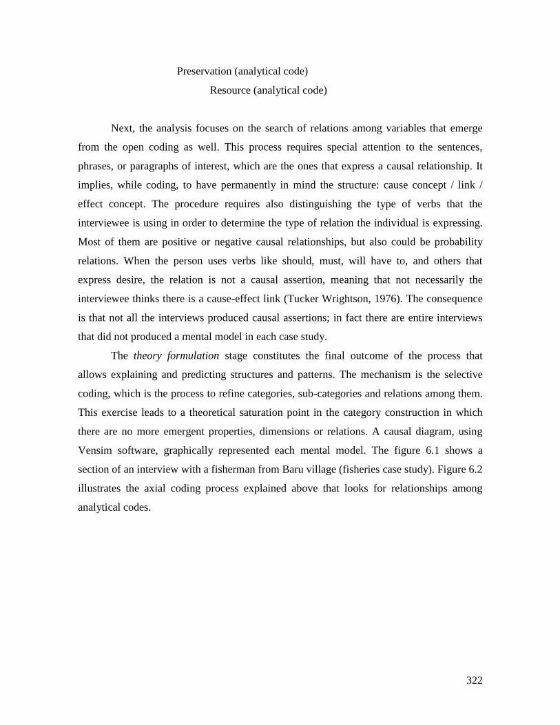
322
Preservation (analytical code)
Resource (analytical code)
Next, the analysis focuses on the search of relations among variables that emerge
from the open coding as well. This process requires special attention to the sentences,
phrases, or paragraphs of interest, which are the ones that express a causal relationship. It
implies, while coding, to have permanently in mind the structure: cause concept / link /
effect concept. The procedure requires also distinguishing the type of verbs that the
interviewee is using in order to determine the type of relation the individual is expressing.
Most of them are positive or negative causal relationships, but also could be probability
relations. When the person uses verbs like should, must, will have to, and others that
express desire, the relation is not a causal assertion, meaning that not necessarily the
interviewee thinks there is a cause-effect link (Tucker Wrightson, 1976). The consequence
is that not all the interviews produced causal assertions; in fact there are entire interviews
that did not produced a mental model in each case study.
The theory formulation stage constitutes the final outcome of the process that
allows explaining and predicting structures and patterns. The mechanism is the selective
coding, which is the process to refine categories, sub-categories and relations among them.
This exercise leads to a theoretical saturation point in the category construction in which
there are no more emergent properties, dimensions or relations. A causal diagram, using
Vensim software, graphically represented each mental model. The figure 6.1 shows a
section of an interview with a fisherman from Baru village (fisheries case study). Figure 6.2
illustrates the axial coding process explained above that looks for relationships among
analytical codes.
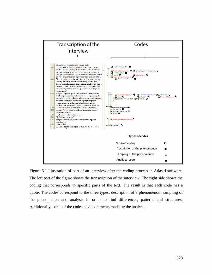
323
Figure 6.1 Illustration of part of an interview after the coding process in Atlas.ti software.
The left part of the figure shows the transcription of the interview. The right side shows the
coding that corresponds to specific parts of the text. The result is that each code has a
quote. The codes correspond to the three types: description of a phenomenon, sampling of
the phenomenon and analysis in order to find differences, patterns and structures.
Additionally, some of the codes have comments made by the analyst.
CodesTranscription of theinterview
“In vivo” coding
Description of the phenomenon
Sampling of the phenomenon
Analitical code
✚
★
★
★
★
★
★
✚
★
★
✚
✚
Types of codes
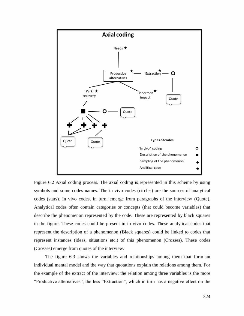
324
Figure 6.2 Axial coding process. The axial coding is represented in this scheme by using
symbols and some codes names. The in vivo codes (circles) are the sources of analytical
codes (stars). In vivo codes, in turn, emerge from paragraphs of the interview (Quote).
Analytical codes often contain categories or concepts (that could become variables) that
describe the phenomenon represented by the code. These are represented by black squares
in the figure. These codes could be present in in vivo codes. These analytical codes that
represent the description of a phenomenon (Black squares) could be linked to codes that
represent instances (ideas, situations etc.) of this phenomenon (Crosses). These codes
(Crosses) emerge from quotes of the interview.
The figure 6.3 shows the variables and relationships among them that form an
individual mental model and the way that quotations explain the relations among them. For
the example of the extract of the interview; the relation among three variables is the more
“Productive alternatives”, the less “Extraction”, which in turn has a negative effect on the
Axial coding
Productivealternatives
Needs
Park recovery
Fishermenimpact
Extraction
Quote
✚✚ ✚✚
QuoteQuote
Quote
“In vivo” coding
Description of the phenomenon
Sampling of the phenomenon
Analitical code
✚
★
Types of codes
★
★
★
★★
325
“Resource”; the more “extraction” the less “Resource”. The quote that supports this relation
in this part of the interview is:
“I think if there are alternatives for taking them [fishermen] out of the Park for
extraction or other activities, and give them a better opportunity decreasing that
impact that we are causing, I think that the Park could recover. But if there is no that
option for decrease that impact, the Park never will recover […] If we, fishermen, are
offered with another work opportunity different from fishing, then we could
contribute to the preservation ”
Figure 6.3 Variables and relations that form an individual mental model.
6.2.3. Network analysis and the building of the collective mental model
Once the variables and relationships were defined for individual mental models a
symmetric matrix was built for each one with the information of links between variables.
These matrixes were analyzed using the network analysis software Ucinet (Borgatti,
Variables and relations of the individual mental model
Detail of thecharacterization of therelation between two
variables
Quotation that links the twovariables and qualifies therelation in causality and polarity
326
Everett, & Freeman, 2002). The analysis was performed to have a better understanding of
the mental models structure. Two measures were calculated: degree centrality and
betweenness centrality (Freeman, 1979). The first is defined by the number of connections
a node has. And the second is the operation of weighting the number of pathways that run
through a node. This is an indicator of the intermediary position of each node; meaning that
the nodes with higher values of betweenness are very important in the network structure
because they control the most relevant communication flows (Webb & Bodin, 2008). A
graph of the network showing the degree for each variable was produced to know the
important regions of the network. In and out degree centrality were calculated to know the
influential (out degree) and dependent (in degree) variables of each model. The variables
with higher values were selected as the more influential or independent, and dependent
ones. Once identified these variables in the causal diagrams, they were used to produce
cause and effect trees with a facility of Vensim software (Ventana Systems, Inc., 2010).
The collective mental model for each case study was built by adding the individual
models and including a new model for the variables and relations elicited from the
transcripts of RPG activities and the feedback workshop. A core structure of the collective
model was defined with the variables that had the highest total degree and betweeness
values, and relationships that were present in more than one mental model. Finally the
variables and links generated in the collective activities were included as part of the
collective mental model because they were product of participants consensus in the group
activities. The result of this process is a diagram and an explanation about the variables and
cause-effect relationships that give an approximation about the logics, motivations and
structures behind the decision-making.
6.2.4. Discussion about behavior according mental models, and comparison
with behavior in economic experiments
The collective mental model obtained in the previous step was used to qualitatively
formulate behavioral hypotheses about the decision patterns in experiments. Decisions
during the final implementation of the RPG were used as indicators of the functioning of
these mental models in terms of players’ decisions.
327
Experimental data was examined by session and by individual looking for patterns
that allowed to define a typology of players in terms of different levels of cooperation using
extraction, contributions, and rule compliance decisions. Experimental data also was used
to derive other kind of indicators related with perception of the resource, trust, property and
others by examining individual survey information.
6.2.5. Relating mental models finding with institutional arrangements and SES’
context
The mental models contribute to find relevant variables in terms of intermediation and
degree for the decisions of common pool resources users. These findings are related with
the action situation outcomes (Chapter 6) and the context of each case study (Chapter 3).
For example in a given case study, rule compliance is relevant in terms of degree and
intermediation, and extraction decision depends on the opinions about rule compliance,
which in turn is shaped by a particular morality system and trust level, product of the action
situation. This situation has a more deep explanation in the particular context of
colonization and relationships with the government. At the end, the usefulness of the
approach points to management strategies, and the lessons are in how to influence or
manage those central variables having into account the rest of explanatory elements of
collective mental models and the particular relation with institutional arrangements.
The final analysis is a comparison between the collective mental models of each
case study looking for regularities, in order to establish patterns in mental models of
common pool resource users, and institutional arrangements. For the three cases, only one
of the individual mental models is explained and the rest are in annexes. The focus of the
Chapter are the collective mental models of each case.
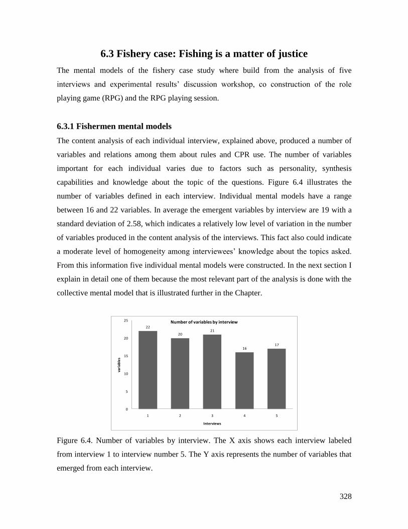
328
6.3 Fishery case: Fishing is a matter of justice
The mental models of the fishery case study where build from the analysis of five
interviews and experimental results’ discussion workshop, co construction of the role
playing game (RPG) and the RPG playing session.
6.3.1 Fishermen mental models
The content analysis of each individual interview, explained above, produced a number of
variables and relations among them about rules and CPR use. The number of variables
important for each individual varies due to factors such as personality, synthesis
capabilities and knowledge about the topic of the questions. Figure 6.4 illustrates the
number of variables defined in each interview. Individual mental models have a range
between 16 and 22 variables. In average the emergent variables by interview are 19 with a
standard deviation of 2.58, which indicates a relatively low level of variation in the number
of variables produced in the content analysis of the interviews. This fact also could indicate
a moderate level of homogeneity among interviewees’ knowledge about the topics asked.
From this information five individual mental models were constructed. In the next section I
explain in detail one of them because the most relevant part of the analysis is done with the
collective mental model that is illustrated further in the Chapter.
Figure 6.4. Number of variables by interview. The X axis shows each interview labeled
from interview 1 to interview number 5. The Y axis represents the number of variables that
emerged from each interview.
22
2021
1617
0
5
10
15
20
25
1 2 3 4 5
vari
able
s
Interviews
Number of variables by interview
329
Mental model 1 (MM1) Productive alternatives oriented
The mental model build from the first interview (Figure 6.5) has 22 variables.
Figure 6.5A portraits the causal diagram of the model. The arrows indicate the relation
among pairs of variables. The red arrows represent positive causal relations. The arrows
have a plus symbol besides in one extreme, meaning that a variation in the cause variable
produces a change in the consequence variable in the same direction. This is, an increase in
X produces and increase in Y, or a decrease in X produces a decrease in Y. The blue arrows
with a minus symbol represent a negative causal relation. This is, if the variable X
increases, the Y variable decreases, and also if X decreases, X increases. Black dotted
arrows represent relations different than causal. The resource variable is affected positively
by rule compliance and the area of reproduction zones. Industrial extraction and artisanal
fishing (extraction) affect negatively the resource, which in turn affects positively the
quality of the future of the village. The more monitoring, the highest rule compliance. Rule
legitimacy affects positively rule compliance. On the other side, the higher the level of
needs, and the more industrial extraction imply less rule compliance. The level of
cooperation is influenced positively by monitoring and awareness of fishermen, and
negatively by the level of needs of fishermen households. These needs affect positively the
levels of extraction, meaning that the more needs, the higher extraction. Productive
alternatives are a strongly influential variable. The increase in other sources of income
represented by this variable generates a decrease in household needs, fishing (extraction)
and the impact produced by fishermen on the ecosystem. In turn, this increase contributes
with the Park recuperation that generates more conservation of marine resources. The
demand of marine products triggers the increase of middlemen. And the transport
infrastructure could bring social problems to the village.
As a result of the network analysis (Figure 6.5B) the variable resource has the
highest degree followed by rule compliance and productive alternatives. Cooperation,
needs, Park recovery and extraction are important variables but their degree is lower. The
Table 6.1 shows, on the first column, the influential variables, which are the variables with
the highest values in out degree, meaning that they have are more relations that goes out
from them towards other variables in the model. The more influential variable in this model
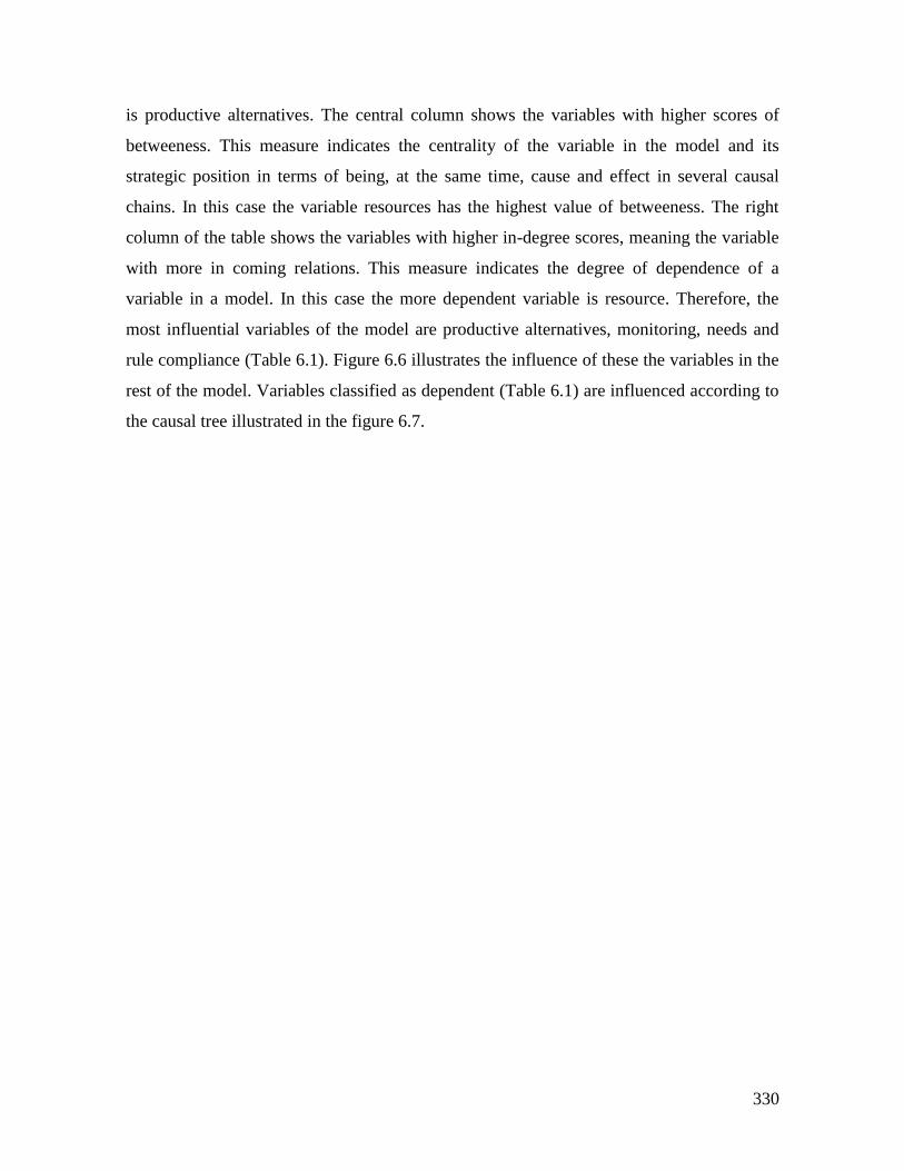
330
is productive alternatives. The central column shows the variables with higher scores of
betweeness. This measure indicates the centrality of the variable in the model and its
strategic position in terms of being, at the same time, cause and effect in several causal
chains. In this case the variable resources has the highest value of betweeness. The right
column of the table shows the variables with higher in-degree scores, meaning the variable
with more in coming relations. This measure indicates the degree of dependence of a
variable in a model. In this case the more dependent variable is resource. Therefore, the
most influential variables of the model are productive alternatives, monitoring, needs and
rule compliance (Table 6.1). Figure 6.6 illustrates the influence of these the variables in the
rest of the model. Variables classified as dependent (Table 6.1) are influenced according to
the causal tree illustrated in the figure 6.7.
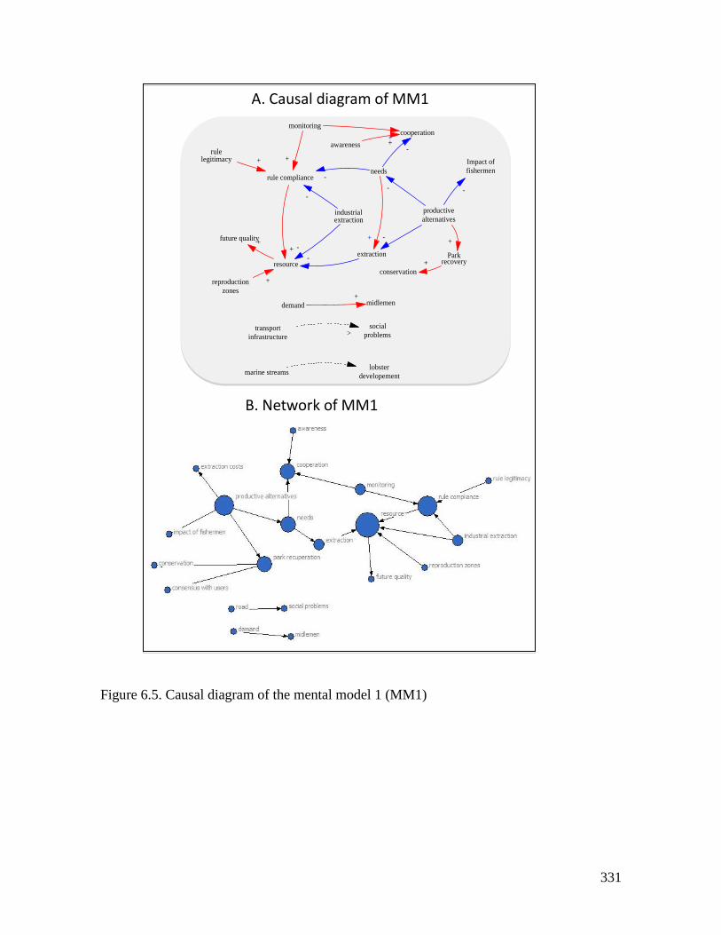
331
Figure 6.5. Causal diagram of the mental model 1 (MM1)
needs
extraction
cooperation
awareness
industrialextraction
-+
rule compliance -
-
resource
-+
-
rulelegitimacy
monitoring
+
+ +
future quality+
reproduction
zones
+
productive
alternatives
conservation
Parkrecovery
Impact of
fishermen
+
-
+
-
-
demand midlemen+
marine streamslobster
developement
transport
infrastructure
social
problems>
+
A. Causal diagram of MM1
B. Network of MM1
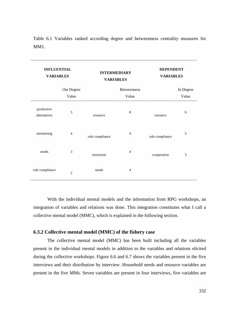
332
Table 6.1 Variables ranked according degree and betweenness centrality measures for
MM1.
INFLUENTIAL
VARIABLES
INTERMEDIARY
VARIABLES
DEPENDENT
VARIABLES
Out Degree
Value
Betweenness
Value
In Degree
Value
productive
alternatives
5
resource 8
resource 6
monitoring
4
rule compliance 4
rule compliance 5
needs
3
extraction 4
cooperation
5
rule compliance
2 needs 4
With the individual mental models and the information from RPG workshops, an
integration of variables and relations was done. This integration constitutes what I call a
collective mental model (MMC), which is explained in the following section.
6.3.2 Collective mental model (MMC) of the fishery case
The collective mental model (MMC) has been built including all the variables
present in the individual mental models in addition to the variables and relations elicited
during the collective workshops. Figure 6.6 and 6.7 shows the variables present in the five
interviews and their distribution by interview. Household needs and resource variables are
present in the five MMs. Seven variables are present in four interviews, five variables are
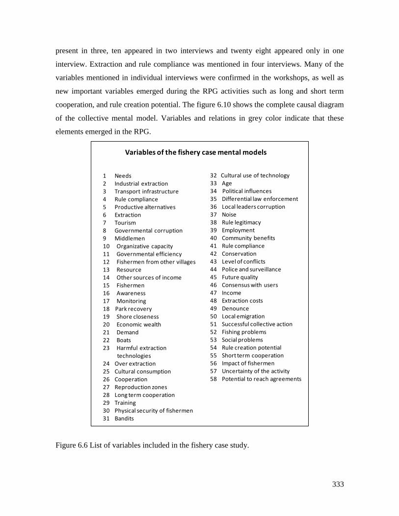
333
present in three, ten appeared in two interviews and twenty eight appeared only in one
interview. Extraction and rule compliance was mentioned in four interviews. Many of the
variables mentioned in individual interviews were confirmed in the workshops, as well as
new important variables emerged during the RPG activities such as long and short term
cooperation, and rule creation potential. The figure 6.10 shows the complete causal diagram
of the collective mental model. Variables and relations in grey color indicate that these
elements emerged in the RPG.
Figure 6.6 List of variables included in the fishery case study.
1 Needs2 Industrial extraction3 Transport infrastructure4 Rule compliance5 Productive alternatives6 Extraction7 Tourism8 Governmental corruption9 Middlemen10 Organizative capacity11 Governmental efficiency12 Fishermen from other villages13 Resource14 Other sources of income15 Fishermen16 Awareness17 Monitoring18 Park recovery19 Shore closeness20 Economic wealth21 Demand22 Boats23 Harmful extraction
technologies24 Over extraction25 Cultural consumption26 Cooperation27 Reproduction zones28 Long term cooperation29 Training30 Physical security of fishermen31 Bandits
32 Cultural use of technology33 Age34 Political influences35 Differential law enforcement36 Local leaders corruption37 Noise38 Rule legitimacy39 Employment40 Community benefits41 Rule compliance42 Conservation43 Level of conflicts44 Police and surveillance45 Future quality46 Consensus with users47 Income48 Extraction costs49 Denounce50 Local emigration51 Successful collective action52 Fishing problems53 Social problems54 Rule creation potential55 Short term cooperation56 Impact of fishermen57 Uncertainty of the activity58 Potential to reach agreements
Variables of the fishery case mental models
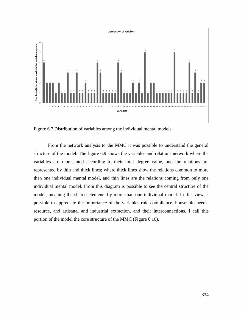
334
Figure 6.7 Distribution of variables among the individual mental models.
From the network analysis to the MMC it was possible to understand the general
structure of the model. The figure 6.9 shows the variables and relations network where the
variables are represented according to their total degree value, and the relations are
represented by thin and thick lines; where thick lines show the relations common to more
than one individual mental model, and thin lines are the relations coming from only one
individual mental model. From this diagram is possible to see the central structure of the
model, meaning the shared elements by more than one individual model. In this view is
possible to appreciate the importance of the variables rule compliance, household needs,
resource, and artisanal and industrial extraction, and their interconnections. I call this
portion of the model the core structure of the MMC (Figure 6.10).
4
2 2 2
1
2
1 1
3
1 1
3
1 1
2
1 1 1
4
3
1 1 1 1 1
4
3
1 1 1
2
1
2
1
5
1
2 2
1 1 1 1 1 1
5
1 1 1 1
4
1
3
1
2 2
0
1
2
3
4
5
6
1 2 3 4 5 6 7 8 9 10 11 12 13 14 15 16 17 18 19 20 21 22 23 24 25 26 27 28 29 30 31 32 33 34 35 36 37 38 39 40 41 42 43 44 45 46 47 48 49 50 51 52 53 54 55
Nu
mb
er o
f in
terv
iew
s in
wh
ich
th
e va
riab
le a
pp
ears
Variables
Distribution of variables
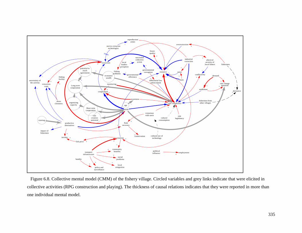
335
Figure 6.8. Collective mental model (CMM) of the fishery village. Circled variables and grey links indicate that were elicited in
collective activities (RPG construction and playing). The thickness of causal relations indicates that they were reported in more than
one individual mental model.
midlemen
rule compliance
rule changepotential
demand
-
+
+
+
productive
alternatives
needs
impact of
fishermen
Park
recovery
-
+-
differential law
enforcement
-
governmental
corruption
+
extraction
nocive extracton
technologies
reproduction
zones
-
-
police and
surveillance
bandits
+
transport
infrastructure
tourism
community
benefits+
resource
future
quality
+
local
emigration
social
problems
+
+
+
+
shore
closeness
fishing
facility
extraction
costs
-
+
consensus
with users
+
+
cultural use of
technology
cooperation
awareness
+
+
conflictivity
physical
security of
local fishers
-
+
cultural
consumption
-
monitoring
+
-
local
leaders
corruption
succesfull
collective
action-
-
governmental
efficiency
-
+
industrial
extraction
-
-
-
+
rule
legitimacy
+
fishermen from
other villages
-+
denounce
fishermen
-
fishing
problems-
political
influence employment+
-
+
+uncertainty of
the activity
-
+
+
noise-
+
-
income
fish price
+
+
boats
+
-
overextraction+
+
+
+
conservation+
-
+
-+
rule
creation
potential
-
organizing
capacity
Short term
cooperation
Long term
cooperation
potential to
reach
agreements
economic
wealth
+
-
+
+
+
+
+
+
age-
training
+
-
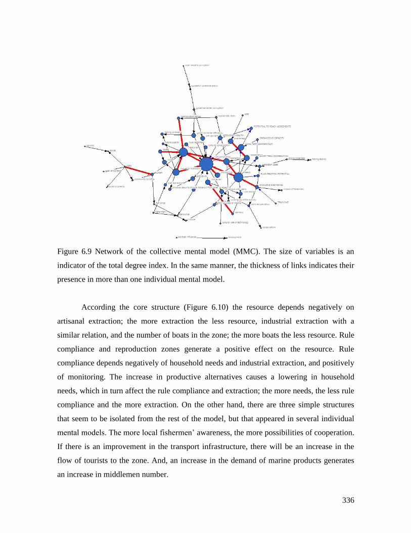
336
Figure 6.9 Network of the collective mental model (MMC). The size of variables is an
indicator of the total degree index. In the same manner, the thickness of links indicates their
presence in more than one individual mental model.
According the core structure (Figure 6.10) the resource depends negatively on
artisanal extraction; the more extraction the less resource, industrial extraction with a
similar relation, and the number of boats in the zone; the more boats the less resource. Rule
compliance and reproduction zones generate a positive effect on the resource. Rule
compliance depends negatively of household needs and industrial extraction, and positively
of monitoring. The increase in productive alternatives causes a lowering in household
needs, which in turn affect the rule compliance and extraction; the more needs, the less rule
compliance and the more extraction. On the other hand, there are three simple structures
that seem to be isolated from the rest of the model, but that appeared in several individual
mental models. The more local fishermen’ awareness, the more possibilities of cooperation.
If there is an improvement in the transport infrastructure, there will be an increase in the
flow of tourists to the zone. And, an increase in the demand of marine products generates
an increase in middlemen number.
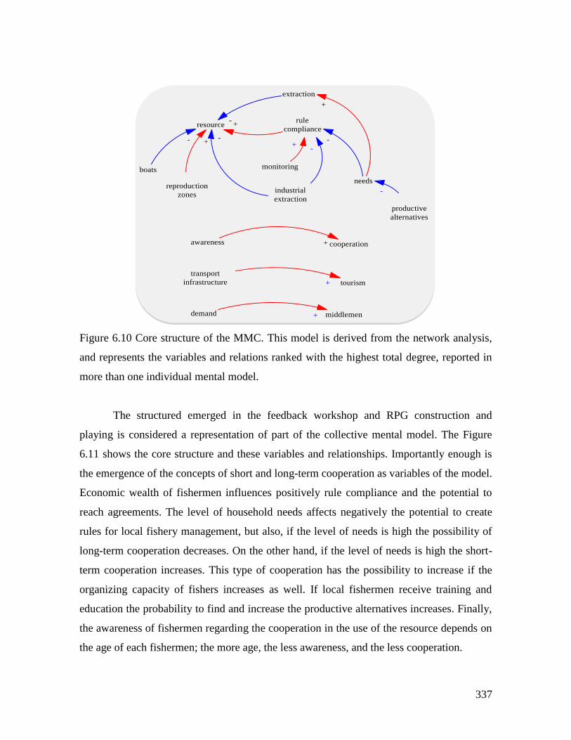
337
Figure 6.10 Core structure of the MMC. This model is derived from the network analysis,
and represents the variables and relations ranked with the highest total degree, reported in
more than one individual mental model.
The structured emerged in the feedback workshop and RPG construction and
playing is considered a representation of part of the collective mental model. The Figure
6.11 shows the core structure and these variables and relationships. Importantly enough is
the emergence of the concepts of short and long-term cooperation as variables of the model.
Economic wealth of fishermen influences positively rule compliance and the potential to
reach agreements. The level of household needs affects negatively the potential to create
rules for local fishery management, but also, if the level of needs is high the possibility of
long-term cooperation decreases. On the other hand, if the level of needs is high the short-
term cooperation increases. This type of cooperation has the possibility to increase if the
organizing capacity of fishers increases as well. If local fishermen receive training and
education the probability to find and increase the productive alternatives increases. Finally,
the awareness of fishermen regarding the cooperation in the use of the resource depends on
the age of each fishermen; the more age, the less awareness, and the less cooperation.
rule
complianceresource
extraction
needs
industrial
extraction
-+
-
+
-
monitoring
+
productive
alternatives
-
awareness cooperation+
reproduction
zones
+
demand middlemen+
-
tourism
transport
infrastructure +
boats
-
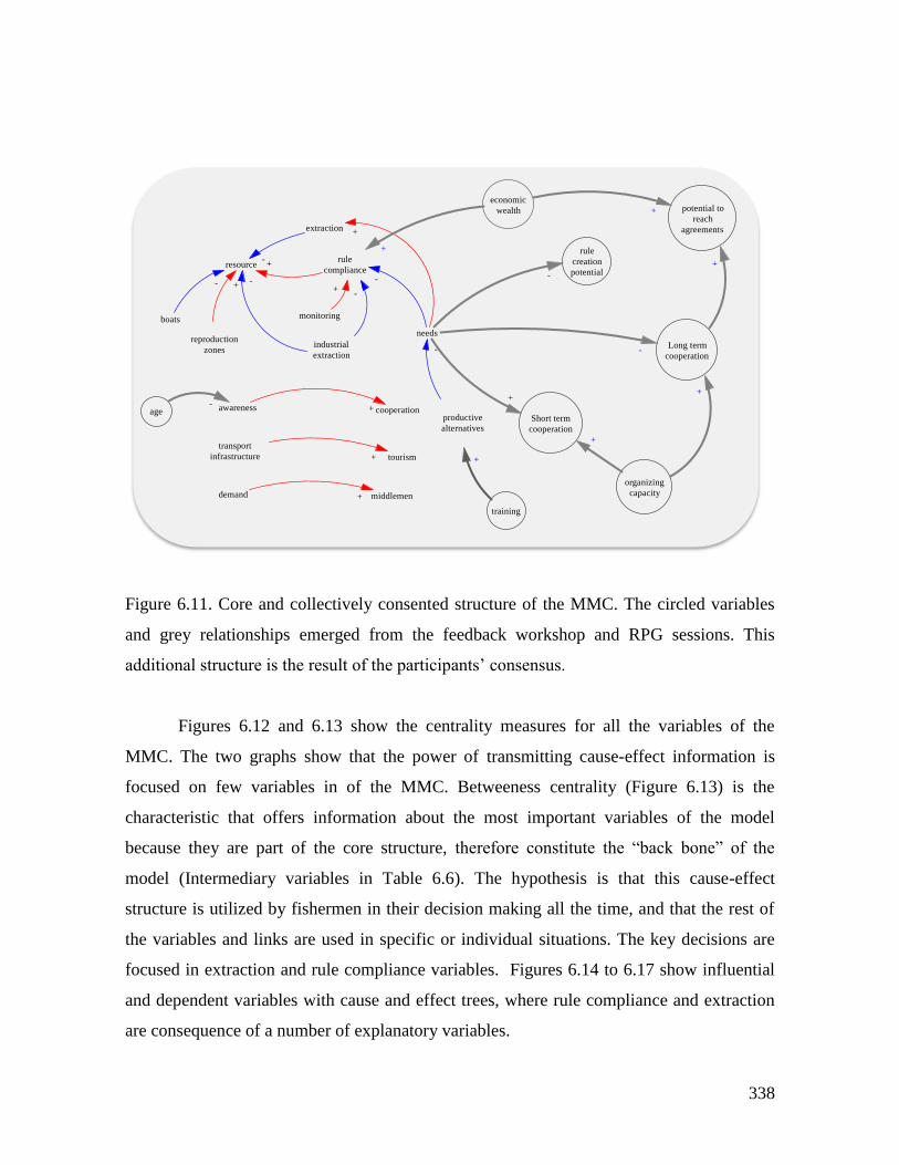
338
Figure 6.11. Core and collectively consented structure of the MMC. The circled variables
and grey relationships emerged from the feedback workshop and RPG sessions. This
additional structure is the result of the participants’ consensus.
Figures 6.12 and 6.13 show the centrality measures for all the variables of the
MMC. The two graphs show that the power of transmitting cause-effect information is
focused on few variables in of the MMC. Betweeness centrality (Figure 6.13) is the
characteristic that offers information about the most important variables of the model
because they are part of the core structure, therefore constitute the “back bone” of the
model (Intermediary variables in Table 6.6). The hypothesis is that this cause-effect
structure is utilized by fishermen in their decision making all the time, and that the rest of
the variables and links are used in specific or individual situations. The key decisions are
focused in extraction and rule compliance variables. Figures 6.14 to 6.17 show influential
and dependent variables with cause and effect trees, where rule compliance and extraction
are consequence of a number of explanatory variables.
rule
complianceresource
extraction
needs
industrial
extraction
-+
-
+
-
monitoring
+
productive
alternatives
-
awareness cooperation+
reproduction
zones
+
demand middlemen+
-
tourism
transport
infrastructure +
boats
-
age
rule
creation
potential
Short term
cooperation
organizing
capacity
Long term
cooperation
potential to
reach
agreements
training
-
+
+
+
+
economic
wealth
+
+
-
-
+
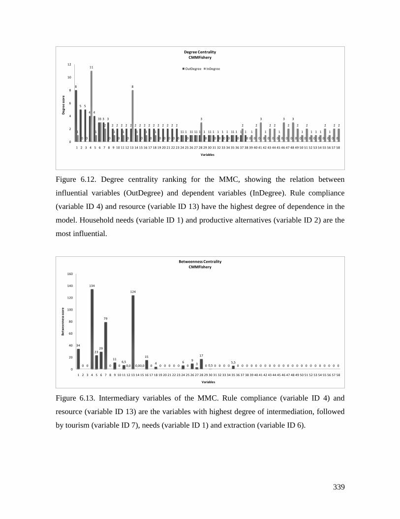
339
Figure 6.12. Degree centrality ranking for the MMC, showing the relation between
influential variables (OutDegree) and dependent variables (InDegree). Rule compliance
(variable ID 4) and resource (variable ID 13) have the highest degree of dependence in the
model. Household needs (variable ID 1) and productive alternatives (variable ID 2) are the
most influential.
Figure 6.13. Intermediary variables of the MMC. Rule compliance (variable ID 4) and
resource (variable ID 13) are the variables with highest degree of intermediation, followed
by tourism (variable ID 7), needs (variable ID 1) and extraction (variable ID 6).
8
5 5
4 4
3 3 3
2 2 2 2 2 2 2 2 2 2 2 2 2 2 2
1 1 1 1 1 1 1 1 1 1 1 1 1 1 1
0 0 0 0 0 0 0 0 0 0 0 0 0 0 0 0 0 0 0 0
1
0 0
11
1
3
2
0
1
0
1
0
8
1
0
1
0
1
0 0 0 0 0
1
0
1 1
3
0
1
0 0 0 0
1
0
2
0
1
2
3
1
2 2
1
3
2
3
2
1
2
1 1 1
2
1
2 2
0
2
4
6
8
10
12
1 2 3 4 5 6 7 8 9 10 11 12 13 14 15 16 17 18 19 20 21 22 23 24 25 26 27 28 29 30 31 32 33 34 35 36 37 38 39 40 41 42 43 44 45 46 47 48 49 50 51 52 53 54 55 56 57 58
De
gre
e s
core
Variables
Degree CentralityCMMFishery
OutDegree InDegree
34
0 0
134
2329
79
0
11
06,5
0,0
124
0,00,0
15
04
0 0 0 0 06
0
93
17
0 0,5 0 0 0 05,5
0 0 0 0 0 0 0 0 0 0 0 0 0 0 0 0 0 0 0 0 0 0 00
20
40
60
80
100
120
140
160
1 2 3 4 5 6 7 8 9 10 11 12 13 14 15 16 17 18 19 20 21 22 23 24 25 26 27 28 29 30 31 32 33 34 35 36 37 38 39 40 41 42 43 44 45 46 47 48 49 50 51 52 53 54 55 56 57 58
Be
twe
en
ne
ss s
core
Variables
Betweenness CentralityCMMFishery
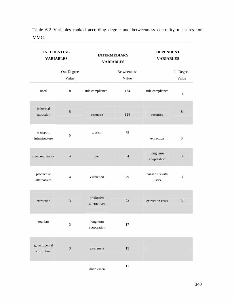
340
Table 6.2 Variables ranked according degree and betweenness centrality measures for
MMC.
INFLUENTIAL
VARIABLES
INTERMEDIARY
VARIABLES
DEPENDENT
VARIABLES
Out Degree
Value
Betweenness
Value
In Degree
Value
need
8
rule compliance
134
rule compliance
11
industrial
extraction
5
resource
124
resource 8
transport
infrastructure
5 tourism
79
extraction
3
rule compliance
4 need 34 long term
cooperation 3
productive
alternatives
4 extraction 29 consensus with
users 3
extraction
3
productive
alternatives
23 extraction costs 3
tourism
3
long term
cooperation
17
governmental
corruption
3 awareness 15
middlemen 11
341
cooperation
9
6.3.3 The collective mental model and the fishing socio ecological system
It is important to make a brief synthesis of the SES because the collective mental model is a
construct that is built and used in this context. As discussed in the Chapter 4 (Historical and
geographical context) the general characteristics of the resource system can be synthetized
as follows. The extension of the fishing grounds is about 40.000 of marine Ha, and its
boundaries as a CPR has been defined traditionally by a history of use of approximately
200 years. Its productivity can be classified as high in the coral reef zones that coincide
with the fishing spots. The units of the resource are highly mobile with a regeneration rate
more or less homogeneous during the year. Its predictability can be classified as low due to
its mobility and also the difficulty to directly observe the resource. Locals and
environmental agencies consider that the resource, currently, is overharvested. These
characteristics make the artisanal fishing an activity with high levels of uncertainty. The
resource system is at the same time part of a marine protected area (National Natural Park),
and also a CPR for the local fishermen. One of the main conflicts characterizing the system
is focused in the tension between ecosystem conservation and the artisanal extraction. The
first position held by the Natural Park policy and the second by the local fishermen. But
also among fishermen there are conflicts between the local fishermen association leaders.
This context and the traditional formal vision of environmental authorities has led to a
generalized mental model that I name “anarchic nature”, in line with Gunderson and
Holling (2001), meaning that the priority must be the conservation and extremely careful
use of ecosystems. The collective mental model is a construct that is built and used in the
context overviewed above. The next paragraphs illustrate how the mental model explains
the outcomes of the different action arenas analyzed in Chapter 5.
Though in figure 6.8 is possible to observe importance of the resource variable, the
figure 6.14 illustrates more clearly the position of the variable in a cause and effect tree
generated from the CMM. The resource depends on the extraction level, industrial
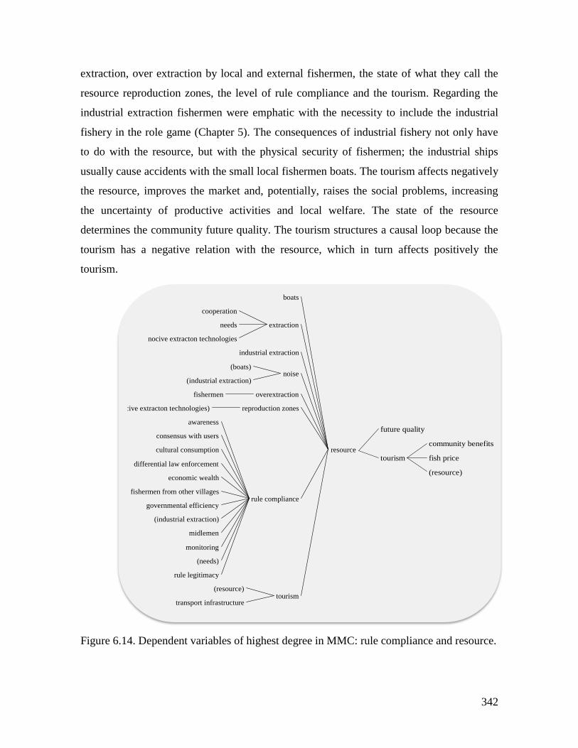
342
extraction, over extraction by local and external fishermen, the state of what they call the
resource reproduction zones, the level of rule compliance and the tourism. Regarding the
industrial extraction fishermen were emphatic with the necessity to include the industrial
fishery in the role game (Chapter 5). The consequences of industrial fishery not only have
to do with the resource, but with the physical security of fishermen; the industrial ships
usually cause accidents with the small local fishermen boats. The tourism affects negatively
the resource, improves the market and, potentially, raises the social problems, increasing
the uncertainty of productive activities and local welfare. The state of the resource
determines the community future quality. The tourism structures a causal loop because the
tourism has a negative relation with the resource, which in turn affects positively the
tourism.
Figure 6.14. Dependent variables of highest degree in MMC: rule compliance and resource.
resource
boats
extraction
cooperation
needs
nocive extracton technologies
industrial extraction
noise(boats)
(industrial extraction)
overextractionfishermen
reproduction zones(nocive extracton technologies)
rule compliance
awareness
consensus with users
cultural consumption
differential law enforcement
economic wealth
fishermen from other villages
governmental efficiency
(industrial extraction)
midlemen
monitoring
(needs)
rule legitimacy
tourism(resource)
transport infrastructure
resource
future quality
tourism
community benefits
fish price
(resource)
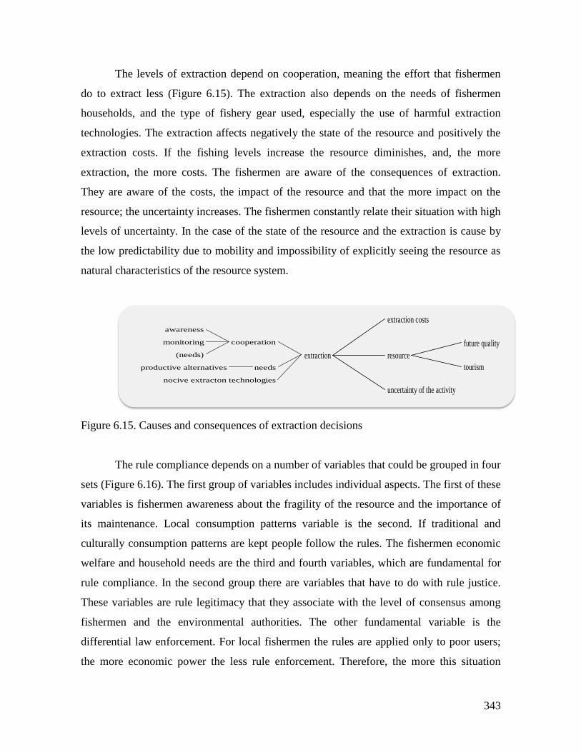
343
The levels of extraction depend on cooperation, meaning the effort that fishermen
do to extract less (Figure 6.15). The extraction also depends on the needs of fishermen
households, and the type of fishery gear used, especially the use of harmful extraction
technologies. The extraction affects negatively the state of the resource and positively the
extraction costs. If the fishing levels increase the resource diminishes, and, the more
extraction, the more costs. The fishermen are aware of the consequences of extraction.
They are aware of the costs, the impact of the resource and that the more impact on the
resource; the uncertainty increases. The fishermen constantly relate their situation with high
levels of uncertainty. In the case of the state of the resource and the extraction is cause by
the low predictability due to mobility and impossibility of explicitly seeing the resource as
natural characteristics of the resource system.
Figure 6.15. Causes and consequences of extraction decisions
The rule compliance depends on a number of variables that could be grouped in four
sets (Figure 6.16). The first group of variables includes individual aspects. The first of these
variables is fishermen awareness about the fragility of the resource and the importance of
its maintenance. Local consumption patterns variable is the second. If traditional and
culturally consumption patterns are kept people follow the rules. The fishermen economic
welfare and household needs are the third and fourth variables, which are fundamental for
rule compliance. In the second group there are variables that have to do with rule justice.
These variables are rule legitimacy that they associate with the level of consensus among
fishermen and the environmental authorities. The other fundamental variable is the
differential law enforcement. For local fishermen the rules are applied only to poor users;
the more economic power the less rule enforcement. Therefore, the more this situation
extraction
extraction costs
resource
future quality
tourism
uncertainty of the activity
extraction
cooperation
awareness
monitoring
(needs)
needsproductive alternatives
nocive extracton technologies
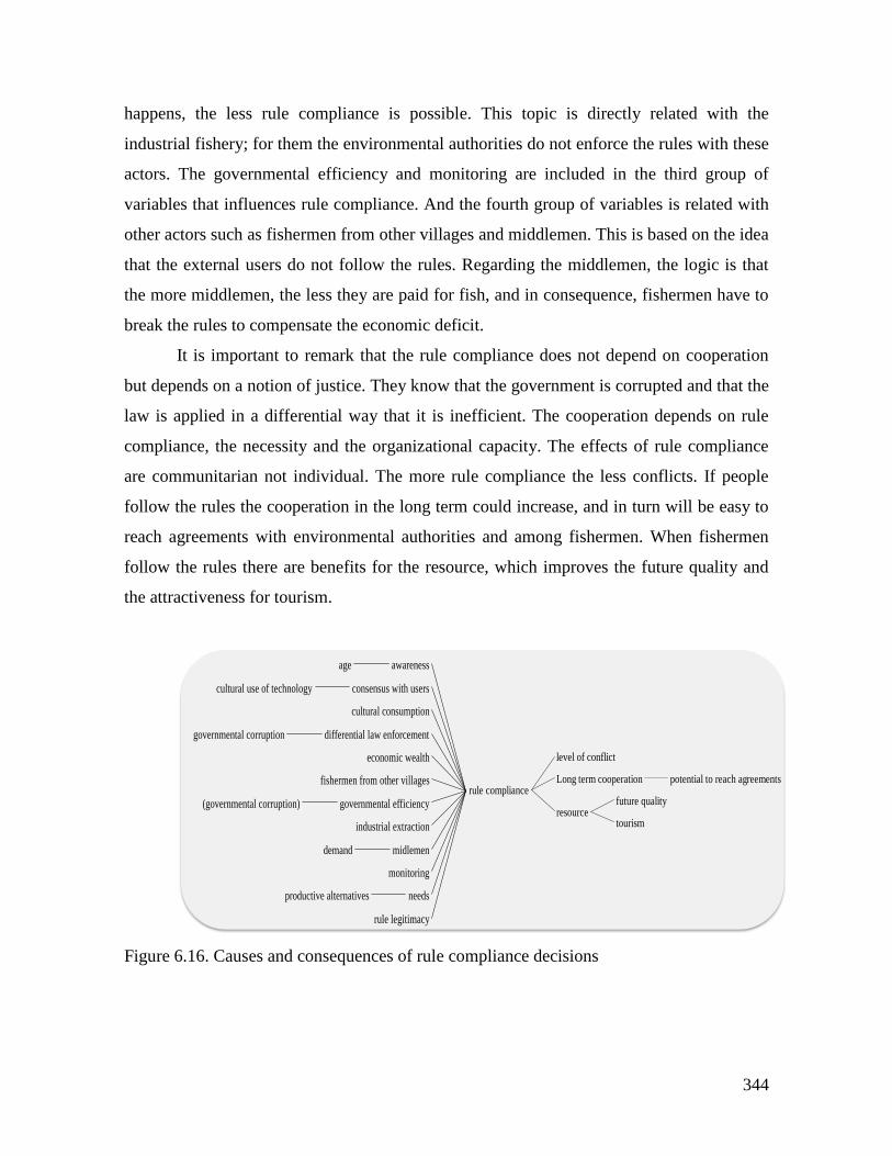
344
happens, the less rule compliance is possible. This topic is directly related with the
industrial fishery; for them the environmental authorities do not enforce the rules with these
actors. The governmental efficiency and monitoring are included in the third group of
variables that influences rule compliance. And the fourth group of variables is related with
other actors such as fishermen from other villages and middlemen. This is based on the idea
that the external users do not follow the rules. Regarding the middlemen, the logic is that
the more middlemen, the less they are paid for fish, and in consequence, fishermen have to
break the rules to compensate the economic deficit.
It is important to remark that the rule compliance does not depend on cooperation
but depends on a notion of justice. They know that the government is corrupted and that the
law is applied in a differential way that it is inefficient. The cooperation depends on rule
compliance, the necessity and the organizational capacity. The effects of rule compliance
are communitarian not individual. The more rule compliance the less conflicts. If people
follow the rules the cooperation in the long term could increase, and in turn will be easy to
reach agreements with environmental authorities and among fishermen. When fishermen
follow the rules there are benefits for the resource, which improves the future quality and
the attractiveness for tourism.
Figure 6.16. Causes and consequences of rule compliance decisions
rule compliance
awarenessage
consensus with userscultural use of technology
cultural consumption
differential law enforcementgovernmental corruption
economic wealth
fishermen from other villages
governmental efficiency(governmental corruption)
industrial extraction
midlemendemand
monitoring
needsproductive alternatives
rule legitimacy
rule compliance
level of conflict
Long term cooperation potential to reach agreements
resourcefuture quality
tourism
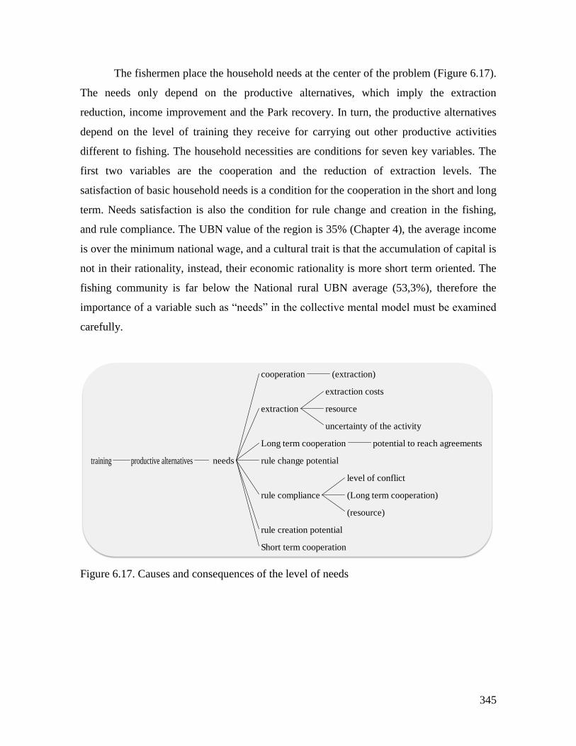
345
The fishermen place the household needs at the center of the problem (Figure 6.17).
The needs only depend on the productive alternatives, which imply the extraction
reduction, income improvement and the Park recovery. In turn, the productive alternatives
depend on the level of training they receive for carrying out other productive activities
different to fishing. The household necessities are conditions for seven key variables. The
first two variables are the cooperation and the reduction of extraction levels. The
satisfaction of basic household needs is a condition for the cooperation in the short and long
term. Needs satisfaction is also the condition for rule change and creation in the fishing,
and rule compliance. The UBN value of the region is 35% (Chapter 4), the average income
is over the minimum national wage, and a cultural trait is that the accumulation of capital is
not in their rationality, instead, their economic rationality is more short term oriented. The
fishing community is far below the National rural UBN average (53,3%), therefore the
importance of a variable such as “needs” in the collective mental model must be examined
carefully.
Figure 6.17. Causes and consequences of the level of needs
needsproductive alternativestraining needs
cooperation (extraction)
extraction
extraction costs
resource
uncertainty of the activity
Long term cooperation potential to reach agreements
rule change potential
rule compliance
level of conflict
(Long term cooperation)
(resource)
rule creation potential
Short term cooperation
346
The state of the resource, cooperation and rule compliance in the experiments
The variables influencing the resource that are present in the experimental arena are
extraction, over extraction, reproduction zones and rule compliance. The outcomes of the
experiments in terms of resource sustainability showed that all the fishing spots started in
good conditions but rapidly felt to a bad state. In the first state of the experiment, without
rules, this fall was faster than what happened in the second stage. According to the mental
model, the decisions that determine the resource’s state and that are included in the
experimental setting are extraction, rule compliance and reproduction zones.
In the experimental action arena (Chapter 5) the extraction of the resource is a proxy
of cooperation levels of the players. This is the less extraction implies more cooperation.
The outcomes of the experimental action arena were dominated by low levels of
cooperation in both stages. In the collective mental model there are two types of
cooperation: short and long term cooperation. Both variables depend positively on the
organizing capacity and also of the needs. When the level of needs increase the short-term
cooperation tends to increase but the long-term cooperation tends to decrease. The players
in the experimental action arena are in a short-term situation. The economic incentives
(game payoffs) could cover approximately one-day real wage that covers the basic
household needs. Therefore, they try to increase the short-term cooperation, but the
organizing capacity is low because they cannot communicate and this fact makes the
cooperation falls. The mental model also includes the monitoring as condition for
cooperation; when monitoring increases, cooperation increases and extraction decreases. In
the experiments, there was no monitoring in the first stage and the cooperation decreases. In
the second stage when rules where in place, the monitoring probability was relatively low
but it was different from zero, and cooperation tended to be stable (Figure 5.1 Chapter 5).
The rule compliance in the experiments was measured by the percentage of rule
breaking (Table 5.1 Chapter 5) where the random access rule had a 14,7% of rule breaking
and the rotation rule 12%. The working variables that condition rule compliance are
consensus with users, governmental efficiency, monitoring, needs and rule legitimacy.
Consensus with users which value is low, due to the lack of communication. The
governmental efficiency and monitoring are represented in this arena by the inspection
probability of the game (0,17 that was the probability of a result of six when a dice is
347
thrown), which is low; therefore the effect is that rule compliance is low. The household
needs play an important role because of the monetary incentives of the experiment that
makes the rule compliance decrease. The rule legitimacy could be understood as moderate
because though the players could vote for the rule to be applied in the game, they could not
design and discuss among players the rule. Therefore is a rule that is perceived as externally
imposed, therefore, the level of rule compliance tends to decrease.
The state of the resource, cooperation and rule compliance in the Role Playing Game
(RPG)
The decision variables present in the RPG action arena are the extraction (fishing effort),
fishing gear and fishing zone (Table 5.2 Chapter 5). The collective mental model includes
three variables that condition the resource extraction; cooperation, household needs and
harmful extraction technologies. These three variables are present in the RPG. The fishing
technologies included in the game had more harvesting capacity proportional to their
resource impact capacity, being the more negative the industrial fishery. In the RPG
participants used most of the time the trolling line; the gear that produced less impact. The
household needs played a central role in their decisions. According to the mental model the
household needs decrease if there are productive alternatives different to fishing, and if the
needs decrease, the extraction decreases. In the RPG when productive alternatives were
introduced participants effectively decrease their effort and the fishing spots started to
recover (see section 5.2.3, Chapter 5). The rule compliance was high in the RPG because
the variable consensus with users played a positive role in the increase of rule compliance.
The meaning of this variable in the mental model is that the rules have to be negotiated
between fishermen and the Park officers. In the RPG that was the situation; a Park officer
participated and discussed the options to decrease the pressure on the resource.
The collective mental model and the behavioral spectrum
The mental model is one of the inputs for the behavioral spectrum (see Chapter 2, section
2.6) of the fishermen in this SES. This behavior spectrum provides a typology of players in
which each type of behavior is supported by the result of the general morality conformance
level (see Chapter 5, section 5.2.5). The first two behavioral types (Table 5.8, Chapter 5)
348
that applies to the local fishermen are “Rule breaker by conviction” and “Rule breaker by
necessity or convenience”, which are directly related with the mental model variable: rule
compliance. There are three causal relations governing these behavioral types: 1) the more
needs, the less rule compliance, 2) the more consensus with users, the more rule
compliance, and 3) the higher the legitimacy of rules, higher rule compliance. The third
behavioral type: “Cheating player” is associated with the causal structure that links cultural
consumption with rule compliance. Here the variable cultural consumption refers to the
traditional extraction and household consumption of species that are not allowed today like
turtles, some gastropods (Strombus gigas) and fish reefs.
Finally it is important to stress the idea mentioned above regarding the relative
importance of household needs compared with the relevance of the variables related with
legitimacy of rules. Having in mind that the average UBN is low compared with the
National figure, I propose a hypothesis that could explain how the mental model and the
levels of morality conformance interact to produce the behavioral spectrum (see Figure
2.15 Chapter 2) explained in Chapter 5.
According to the CMM satisfaction of basic needs is marked by the uncertainty.
Fishermen know that the solution is not in the fishing game but outside of the sea. That is
the reason why fishermen focus on productive alternatives. The cooperation is not a
problem; they claim that the government must propose another “game”, because they know
that they will be excluded from the fishing activity. As a consequence locals are exploring
different options such as the territorial governance model of collective land titling and
communitarian councils, and the touristic productive option. The variables: consensus with
users, differential law enforcement, industrial extraction, governmental efficiency and rule
legitimacy can be classified as justice variables. Justice variables have an important weight
on rule compliance causes, and they are dispersed in different structures of the CMM
(Figure 6.16). The variable “needs” is strategically centrally located in the CMM. It is
easier to claim that decisions that lead to rule breaking are a function of basic needs
satisfaction, than placing on the spot justice issues that imply the reconfiguration of power
relations in the SES.
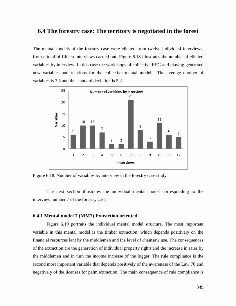
349
6.4 The forestry case: The territory is negotiated in the forest
The mental models of the forestry case were elicited from twelve individual interviews,
from a total of fifteen interviews carried out. Figure 6.18 illustrates the number of elicited
variables by interview. In this case the workshops of collective RPG and playing generated
new variables and relations for the collective mental model. The average number of
variables is 7,5 and the standard deviation is 5,2
Figure 6.18. Number of variables by interview in the forestry case study.
The next section illustrates the individual mental model corresponding to the
interview number 7 of the forestry case.
6.4.1 Mental model 7 (MM7) Extraction oriented
Figure 6.19 portraits the individual mental model structure. The most important
variable in this mental model is the timber extraction, which depends positively on the
financial resources lent by the middlemen and the level of chainsaw use. The consequences
of the extraction are the generation of individual property rights and the increase in sales by
the middlemen and in turn the income increase of the logger. The rule compliance is the
second most important variable that depends positively of the awareness of the Law 70 and
negatively of the licenses for palm extraction. The main consequence of rule compliance is
6
10 10
7
2 2
21
8
3
11
65
0
5
10
15
20
25
1 2 3 4 5 6 7 8 9 10 11 12
Var
iab
les
Interviews
Number of variables by interview
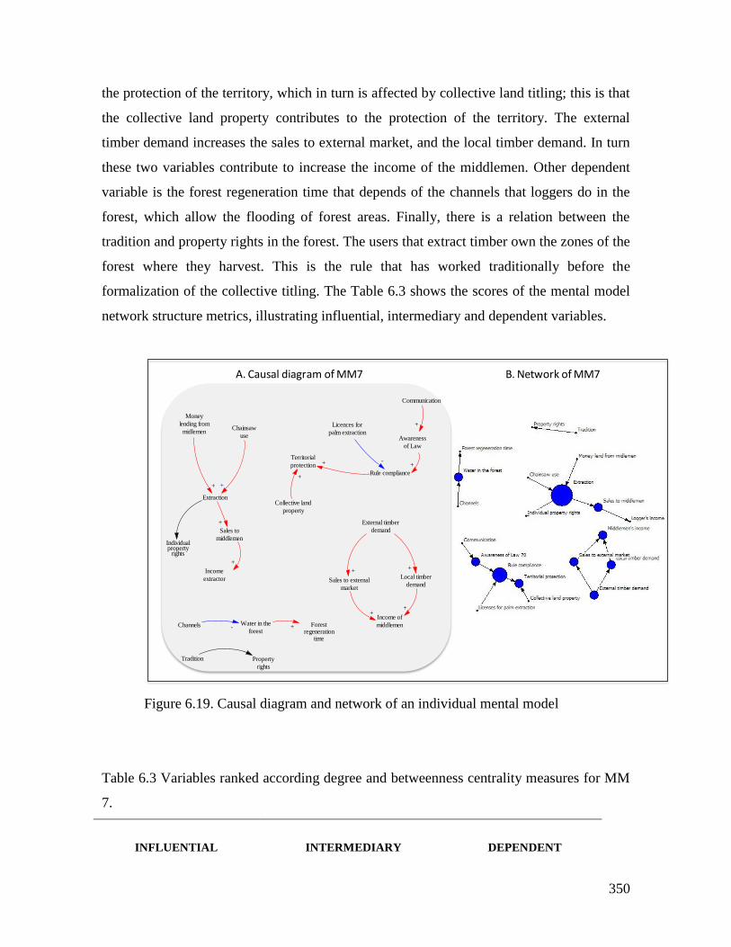
350
the protection of the territory, which in turn is affected by collective land titling; this is that
the collective land property contributes to the protection of the territory. The external
timber demand increases the sales to external market, and the local timber demand. In turn
these two variables contribute to increase the income of the middlemen. Other dependent
variable is the forest regeneration time that depends of the channels that loggers do in the
forest, which allow the flooding of forest areas. Finally, there is a relation between the
tradition and property rights in the forest. The users that extract timber own the zones of the
forest where they harvest. This is the rule that has worked traditionally before the
formalization of the collective titling. The Table 6.3 shows the scores of the mental model
network structure metrics, illustrating influential, intermediary and dependent variables.
Figure 6.19. Causal diagram and network of an individual mental model
Table 6.3 Variables ranked according degree and betweenness centrality measures for MM
7.
INFLUENTIAL
INTERMEDIARY
DEPENDENT
Money
lending from
midlemen
Extraction
+
Chainsaw
use
Individualproperty
rights
Sales to
middlemen
+
Income
extractor
+
Communication
Awareness
of Law
+
Rule compliance
+
Channels Water in the
forestForest
regenerationtime
- +
Licences for
palm extraction
-Territorial
protection +
Tradition Property
rights
Collective land
property
+
External timber
demand
Sales to external
market
Local timber
demand
+ +
Income of
middlemen
++
+
A. Causal diagram of MM7 B. Network of MM7
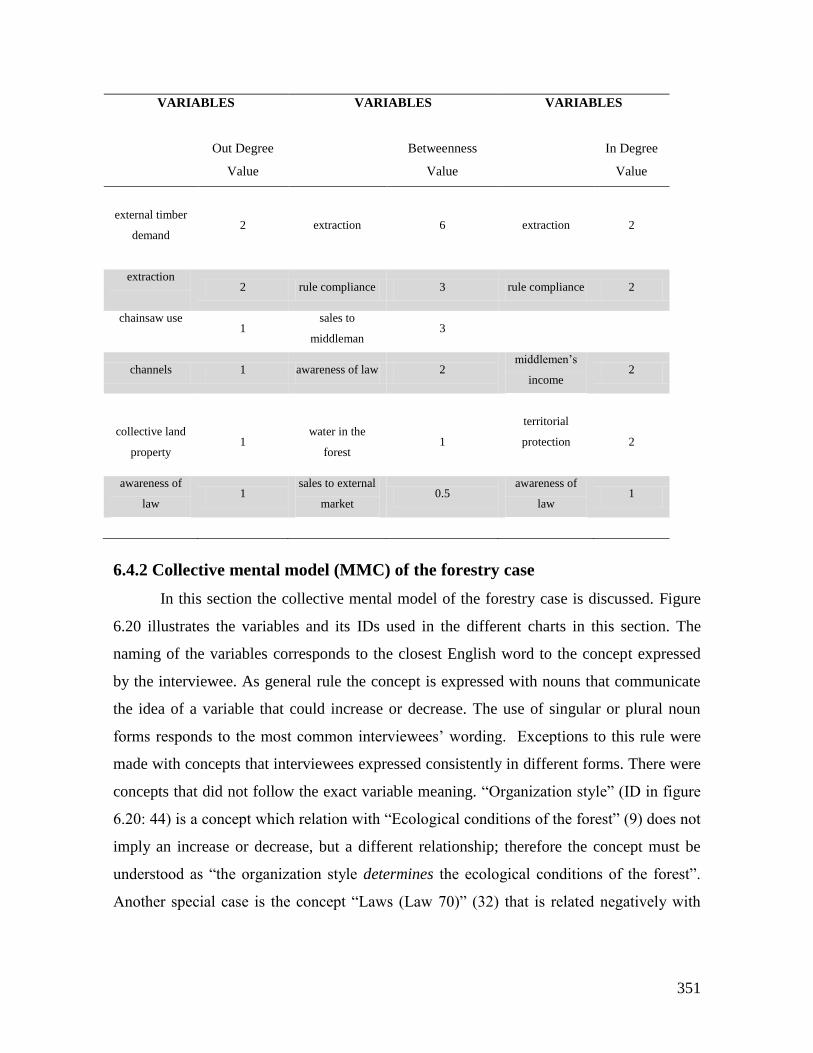
351
VARIABLES
VARIABLES VARIABLES
Out Degree
Value
Betweenness
Value
In Degree
Value
external timber
demand
2 extraction 6 extraction 2
extraction
2 rule compliance 3 rule compliance 2
chainsaw use
1
sales to
middleman 3
channels 1 awareness of law 2 middlemen’s
income 2
collective land
property 1
water in the
forest 1
territorial
protection
2
awareness of
law 1
sales to external
market 0.5
awareness of
law 1
6.4.2 Collective mental model (MMC) of the forestry case
In this section the collective mental model of the forestry case is discussed. Figure
6.20 illustrates the variables and its IDs used in the different charts in this section. The
naming of the variables corresponds to the closest English word to the concept expressed
by the interviewee. As general rule the concept is expressed with nouns that communicate
the idea of a variable that could increase or decrease. The use of singular or plural noun
forms responds to the most common interviewees’ wording. Exceptions to this rule were
made with concepts that interviewees expressed consistently in different forms. There were
concepts that did not follow the exact variable meaning. “Organization style” (ID in figure
6.20: 44) is a concept which relation with “Ecological conditions of the forest” (9) does not
imply an increase or decrease, but a different relationship; therefore the concept must be
understood as “the organization style determines the ecological conditions of the forest”.
Another special case is the concept “Laws (Law 70)” (32) that is related negatively with
352
“External extraction”. The meaning is that the existence of formal laws similar to Law 7046
decreases the possibilities of timber extraction by external actors to the Communitarian
Council ACAPA. The concept “Tradition” (62) is linked with three variables and its
relationship with each one is of different type. With the variable “Individual property
rights” (28) must be understood as “the land individual property rights are associated with
the tradition and vice versa”. Also there is a relation with “Property rights” (48) in a general
sense, meaning that the “tradition determines the property rights of the forest and the land”.
But the general character of the concept (property rights), without specification if they are
individual or collective, makes the assertion either open to free interpretation, or meaning
that the essence of the relation between these two concepts is that always, in a universal
sense, the traditional land and forest utilization determines the type of property rights. A
concept and relationship that reinforces this link is “Working in the land” (66), which
increases the rights over a specific area of the forest (“Individual property rights” (28). The
“Communitary council” (8) concept is linked with “Collective own rules crafting” (6). This
relationship must be understood as “the existence of the Communitary Council is the cause
of, or in this case, makes possible the collective own rules crafting”.
46 National Law that gives autonomy in territorial governance and collective land titling to the Communitarian
Councils in the Colombian Pacific region
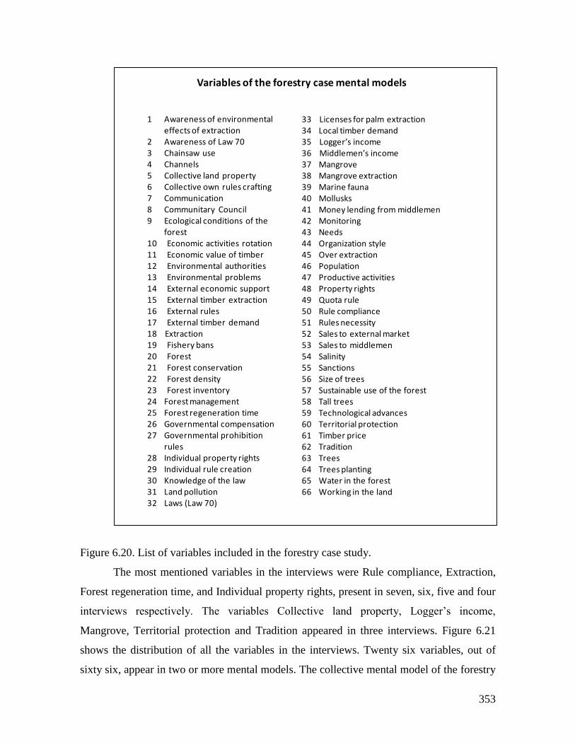
353
Figure 6.20. List of variables included in the forestry case study.
The most mentioned variables in the interviews were Rule compliance, Extraction,
Forest regeneration time, and Individual property rights, present in seven, six, five and four
interviews respectively. The variables Collective land property, Logger’s income,
Mangrove, Territorial protection and Tradition appeared in three interviews. Figure 6.21
shows the distribution of all the variables in the interviews. Twenty six variables, out of
sixty six, appear in two or more mental models. The collective mental model of the forestry
1 Awareness of environmental effects of extraction
2 Awareness of Law 703 Chainsaw use4 Channels5 Collective land property6 Collective own rules crafting7 Communication8 Communitary Council9 Ecological conditions of the
forest10 Economic activities rotation11 Economic value of timber12 Environmental authorities13 Environmental problems14 External economic support15 External timber extraction16 External rules17 External timber demand18 Extraction19 Fishery bans20 Forest21 Forest conservation22 Forest density23 Forest inventory24 Forest management25 Forest regeneration time26 Governmental compensation27 Governmental prohibition
rules28 Individual property rights29 Individual rule creation30 Knowledge of the law31 Land pollution32 Laws (Law 70)
33 Licenses for palm extraction34 Local timber demand35 Logger’s income36 Middlemen’s income37 Mangrove38 Mangrove extraction39 Marine fauna40 Mollusks41 Money lending from middlemen42 Monitoring43 Needs44 Organization style45 Over extraction46 Population47 Productive activities48 Property rights49 Quota rule50 Rule compliance51 Rules necessity52 Sales to external market53 Sales to middlemen54 Salinity55 Sanctions56 Size of trees57 Sustainable use of the forest58 Tall trees59 Technological advances60 Territorial protection61 Timber price62 Tradition63 Trees64 Trees planting65 Water in the forest66 Working in the land
Variables of the forestry case mental models
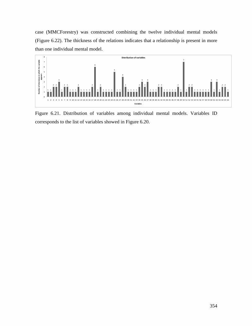
354
case (MMCForestry) was constructed combining the twelve individual mental models
(Figure 6.22). The thickness of the relations indicates that a relationship is present in more
than one individual mental model.
Figure 6.21. Distribution of variables among individual mental models. Variables ID
corresponds to the list of variables showed in Figure 6.20.
1 1
2 2
3
1
2 2
1 1 1
2
1 1 1 1
2
6
1
2
1 1 1 1
5
1 1
4
2
1 1 1 1
2
3
2
3
1 1 1
2 2
1 1 1 1 1
2
1
7
1
2 2
1 1 1 1 1 1
3
1
3
1
2 2
1
0
1
2
3
4
5
6
7
8
1 2 3 4 5 6 7 8 9 10 11 12 13 14 15 16 17 18 19 20 21 22 23 24 25 26 27 28 29 30 31 32 33 34 35 36 37 38 39 40 41 42 43 44 45 46 47 48 49 50 51 52 53 54 55 56 57 58 59 60 61 62 63 64 65 66
Nu
mb
er
of
inte
rvie
ws
in w
hic
h t
he
var
iab
le
app
ear
s
Variables
Distribution of variables
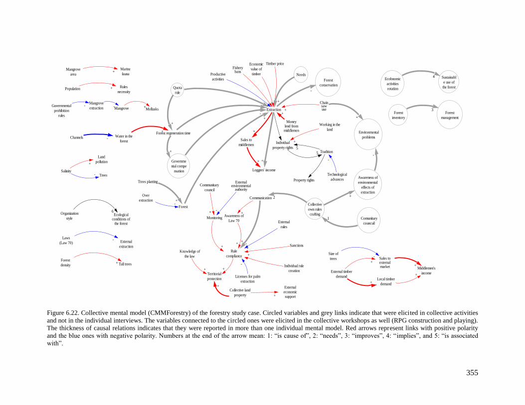
355
Figure 6.22. Collective mental model (CMMForestry) of the forestry study case. Circled variables and grey links indicate that were elicited in collective activities
and not in the individual interviews. The variables connected to the circled ones were elicited in the collective workshops as well (RPG construction and playing).
The thickness of causal relations indicates that they were reported in more than one individual mental model. Red arrows represent links with positive polarity
and the blue ones with negative polarity. Numbers at the end of the arrow mean: 1: “is cause of”, 2: “needs”, 3: “improves”, 4: “implies”, and 5: “is associated
with”.
Individual
property rightsTradition5
5
Mangrove
area
Marine
fauna+
Population Rules
necessity+
SalinityTrees
Land
pollution
-
+
Economic
value of
timber
Extraction
Knowledge of
the law
Mollusks
+
Territorial
protection
+
Mangrove +
Timber price
+
Monitoring
Rule
compliance
+
Forest
density Tall trees+
Channels Water in the
forest
Forest regeneration time
-
+
Laws
(Law 70) External
extraction
-
Guvernmental
prohibition
rules
Mangrove
extraction- -
Technological
advances
-
Organization
styleEcological
conditions ofthe forest
6
Collective land
property
Externaleconomicsupport+
Moneylend from
middlemen
+
Chainsawuse+
Sales to
middlemen
+
Loggers' income
+
Property rights
Awareness of
Law 70
Communication
+
+
Licenses for palm
extraction
-
+
+
External timber
demand
Sales toexternalmarket
+
Local timber
demand+
Middlemen's
income
+
+
Fisherybans
Productive
activities
+-
Forest
Trees planting
Over
extraction +-
External
rules
Individual rule
creation
-
+
Externalenvironmental
authority
-
Communitary
council
+
Sanctions+
Size of
trees-
Working in the
land
+
+
Needs
+
Quota
rule
-
+
+
+
Governme
ntal compe
nsation
+
-
Forest
conservation
-
Forest
inventory
Forest
management
3
Ecobnomic
activities
rotation
Sustainabl
e use of
the forest
4
Comunitary
councuil
Collective
own rules
crafting1
2
+
Awareness of
environmental
effects of
extraction+
Environmental
problems
-
+
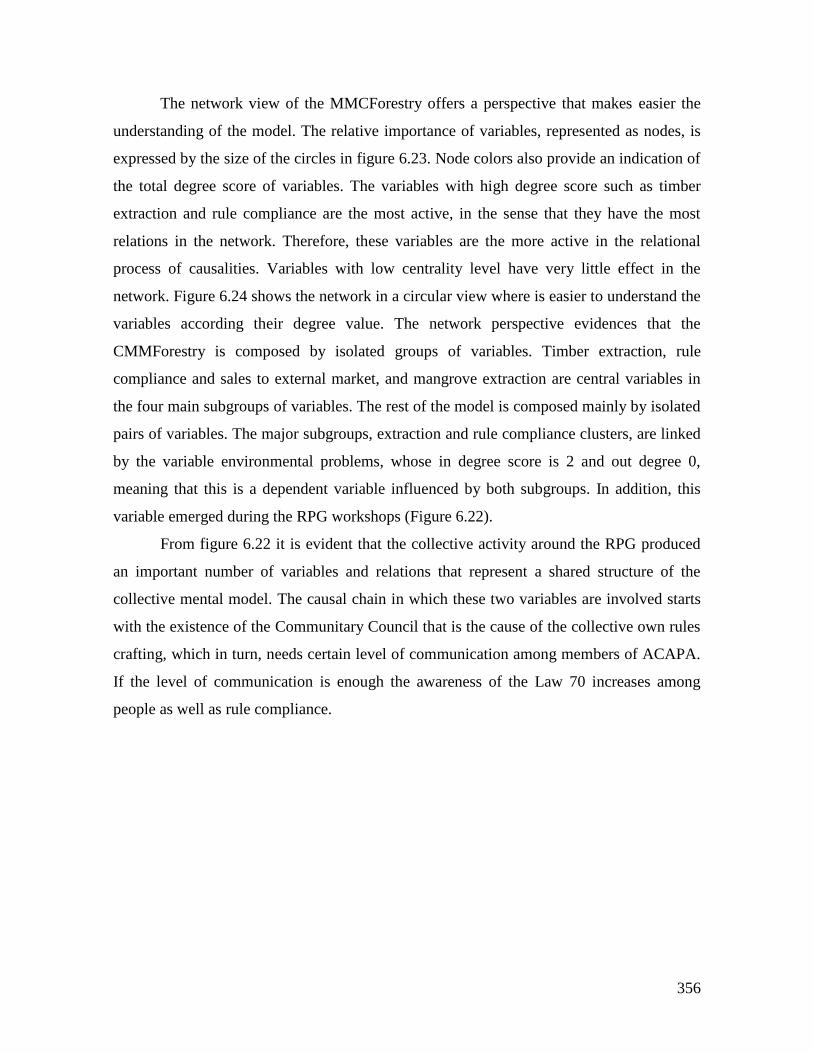
356
The network view of the MMCForestry offers a perspective that makes easier the
understanding of the model. The relative importance of variables, represented as nodes, is
expressed by the size of the circles in figure 6.23. Node colors also provide an indication of
the total degree score of variables. The variables with high degree score such as timber
extraction and rule compliance are the most active, in the sense that they have the most
relations in the network. Therefore, these variables are the more active in the relational
process of causalities. Variables with low centrality level have very little effect in the
network. Figure 6.24 shows the network in a circular view where is easier to understand the
variables according their degree value. The network perspective evidences that the
CMMForestry is composed by isolated groups of variables. Timber extraction, rule
compliance and sales to external market, and mangrove extraction are central variables in
the four main subgroups of variables. The rest of the model is composed mainly by isolated
pairs of variables. The major subgroups, extraction and rule compliance clusters, are linked
by the variable environmental problems, whose in degree score is 2 and out degree 0,
meaning that this is a dependent variable influenced by both subgroups. In addition, this
variable emerged during the RPG workshops (Figure 6.22).
From figure 6.22 it is evident that the collective activity around the RPG produced
an important number of variables and relations that represent a shared structure of the
collective mental model. The causal chain in which these two variables are involved starts
with the existence of the Communitary Council that is the cause of the collective own rules
crafting, which in turn, needs certain level of communication among members of ACAPA.
If the level of communication is enough the awareness of the Law 70 increases among
people as well as rule compliance.
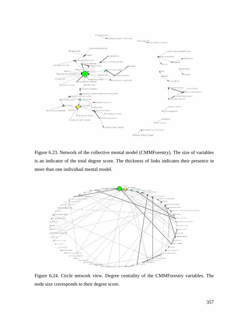
357
Figure 6.23. Network of the collective mental model (CMMForestry). The size of variables
is an indicator of the total degree score. The thickness of links indicates their presence in
more than one individual mental model.
Figure 6.24. Circle network view. Degree centrality of the CMMForestry variables. The
node size corresponds to their degree score.
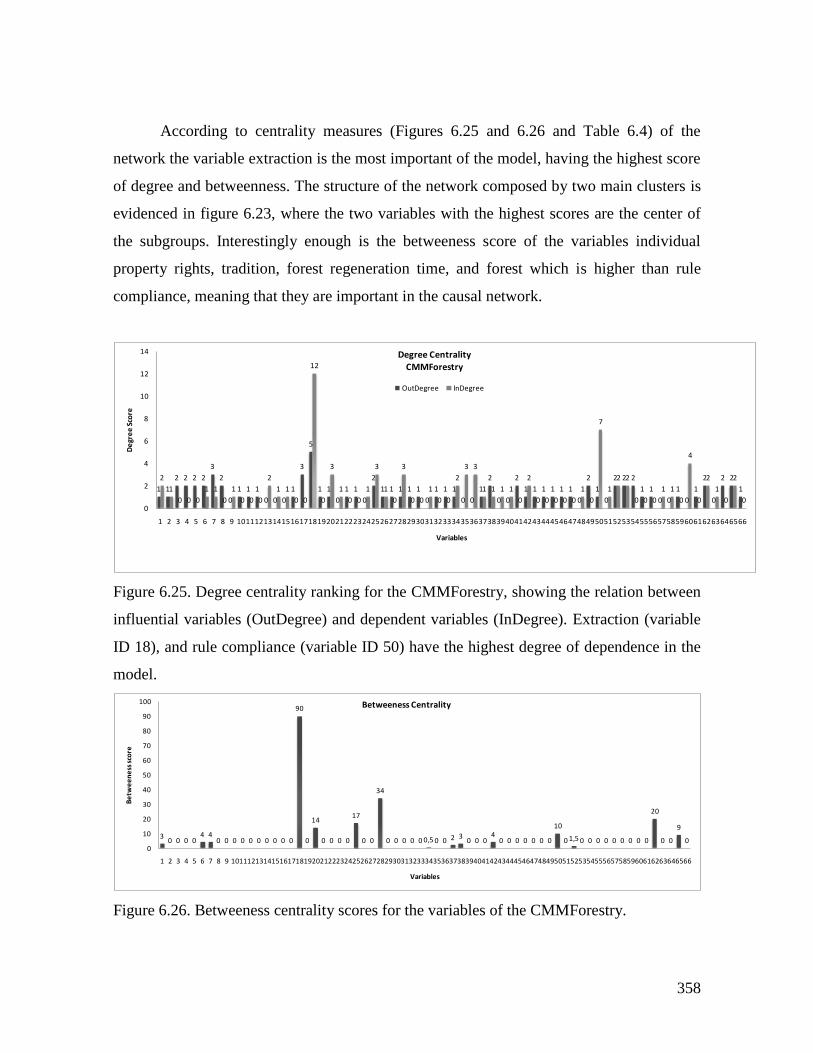
358
According to centrality measures (Figures 6.25 and 6.26 and Table 6.4) of the
network the variable extraction is the most important of the model, having the highest score
of degree and betweenness. The structure of the network composed by two main clusters is
evidenced in figure 6.23, where the two variables with the highest scores are the center of
the subgroups. Interestingly enough is the betweeness score of the variables individual
property rights, tradition, forest regeneration time, and forest which is higher than rule
compliance, meaning that they are important in the causal network.
Figure 6.25. Degree centrality ranking for the CMMForestry, showing the relation between
influential variables (OutDegree) and dependent variables (InDegree). Extraction (variable
ID 18), and rule compliance (variable ID 50) have the highest degree of dependence in the
model.
Figure 6.26. Betweeness centrality scores for the variables of the CMMForestry.
1 1
2 2 2 2
3
2
0
1 1 1
0 0 0
1
3
5
1 1
0
1 1
0
2
1 1 1 1 1
0
1 1 1
0 0
1
2
0 0
2
1 1 1 1 1 1
0
2
1
0
2 2 2
1 1
0 0
1
0
1
2
0
2 2
1
2
1
0 0 0
1 1
0
1
0 0 0
2
1 1
0 0
12
0
3
1
0 0
1
3
1
0
3
0 0
1
0 0
2
3 3
1 1 1 1
0
2
0 0 0 0 0
1
0
7
1
2 2
0 0 0
1 1
0
4
0
2
1
0
2
00
2
4
6
8
10
12
14
1 2 3 4 5 6 7 8 9 101112131415161718192021222324252627282930313233343536373839404142434445464748495051525354555657585960616263646566
De
gre
e S
core
Variables
Degree Centrality
CMMForestry
OutDegree InDegree
30 0 0 0
4 40 0 0 0 0 0 0 0 0 0
90
0
14
0 0 0 0
17
0 0
34
0 0 0 0 0 0,5 0 0 2 30 0 0
40 0 0 0 0 0 0
10
0 1,5 0 0 0 0 0 0 0 0 0
20
0 0
9
00
10
20
30
40
50
60
70
80
90
100
1 2 3 4 5 6 7 8 9 101112131415161718192021222324252627282930313233343536373839404142434445464748495051525354555657585960616263646566
Be
twe
en
ess
sco
re
Variables
Betweeness Centrality
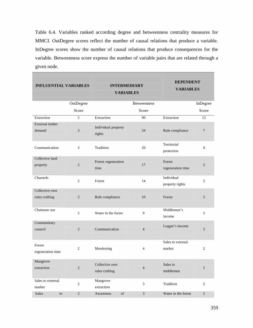
359
Table 6.4. Variables ranked according degree and betweenness centrality measures for
MMCI. OutDegree scores reflect the number of causal relations that produce a variable.
InDegree scores show the number of causal relations that produce consequences for the
variable. Betweenness score express the number of variable pairs that are related through a
given node.
INFLUENTIAL VARIABLES
INTERMEDIARY
VARIABLES
DEPENDENT
VARIABLES
OutDegree
Score
Betweenness
Score
InDegree
Score
Extraction 5 Extraction 90 Extraction 12
External timber
demand
3 Individual property
rights 34 Rule compliance 7
Communication 3 Tradition 20 Territorial
protection 4
Collective land
property
2 Forest regeneration
time 17
Forest
regeneration time 3
Channels
2 Forest 14
Individual
property rights 3
Collective own
rules crafting
2 Rule compliance 10 Forest 3
Chainsaw use
2 Water in the forest 9
Middlemen’s
income 3
Communitary
council
2 Communication 4 Logger’s income
3
Forest
regeneration time 2 Monitoring 4
Sales to external
market
2
Mangrove
extraction
2 Collective own
rules crafting 4
Sales to
middlemen 2
Sales to external
market 2
Mangrove
extraction 3 Tradition 2
Sales to 2 Awareness of 3 Water in the forest 2
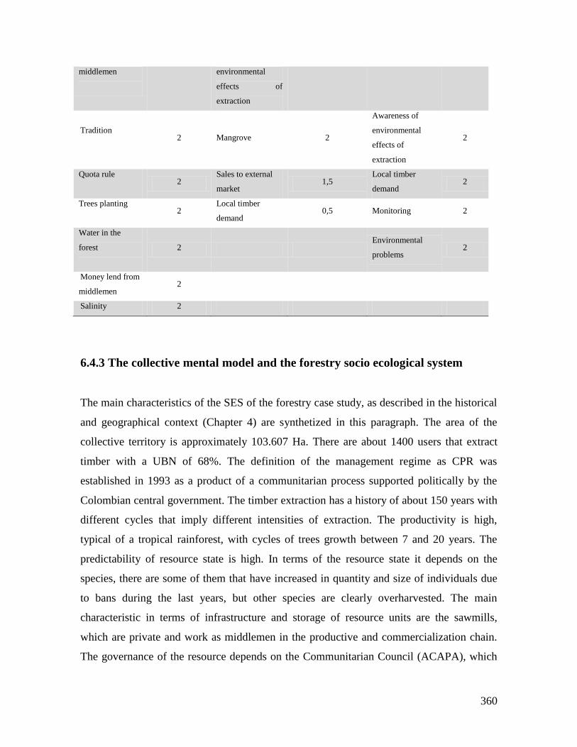
360
middlemen
environmental
effects of
extraction
Tradition
2 Mangrove 2
Awareness of
environmental
effects of
extraction
2
Quota rule
2
Sales to external
market 1,5
Local timber
demand 2
Trees planting
2
Local timber
demand 0,5 Monitoring 2
Water in the
forest
2 Environmental
problems 2
Money lend from
middlemen 2
Salinity 2
6.4.3 The collective mental model and the forestry socio ecological system
The main characteristics of the SES of the forestry case study, as described in the historical
and geographical context (Chapter 4) are synthetized in this paragraph. The area of the
collective territory is approximately 103.607 Ha. There are about 1400 users that extract
timber with a UBN of 68%. The definition of the management regime as CPR was
established in 1993 as a product of a communitarian process supported politically by the
Colombian central government. The timber extraction has a history of about 150 years with
different cycles that imply different intensities of extraction. The productivity is high,
typical of a tropical rainforest, with cycles of trees growth between 7 and 20 years. The
predictability of resource state is high. In terms of the resource state it depends on the
species, there are some of them that have increased in quantity and size of individuals due
to bans during the last years, but other species are clearly overharvested. The main
characteristic in terms of infrastructure and storage of resource units are the sawmills,
which are private and work as middlemen in the productive and commercialization chain.
The governance of the resource depends on the Communitarian Council (ACAPA), which
361
has a directive board with representatives of the different regions of the territory. It is
important to remark that the forest governance is only a part of the governance role of
ACAPA, which is a grass roots organization for the territorial governance with full
recognition of the Colombian Government. The use and management rules are collectively
defined, in line with the environmental state agency, but with very low monitoring capacity.
The main conflicts are of two kinds. On one hand there are internal conflicts among leaders
focused on diverse political objectives and corruption issues. On the other hand, there are
territorial governance conflicts with illegal armed groups. The region in general has been
used and managed traditionally under a mental model of nature balanced; meaning that the
ecosystems recover themselves no matter the strength of perturbations and extraction. The
collective mental model illustrates the way in which local users make decisions in this
context.
The forest depends on individual decisions linked to the extraction level, but also on
collective decisions related with trees planting. The communitarian dimension is highly
important because the state of the resource is linked to the social organization
consolidation. The state of the resource and the regeneration time depends on the existence
of a quota rule in order to limit the extraction. This quota rule does not exist currently, but
for the participants in the workshops if it would exist, will improve the resource condition.
If the density of trees increases, the number of tall trees increases and the regeneration will
be better. This allows the possibility to more extraction and also the community could
obtain benefits from the government. The collective mental model makes evident the
awareness about basic ecological forest dynamics. The mangroves contributes to increase
and maintains the marine fauna. If water salinity levels increase there are negative effects
on the forest state. Regarding the sustainable use and management of the resource, they
depend on the knowledge about the forest, and the possibility of productive activities
rotation.
According the CMMForestry timber extraction is a variable that depends of several
variables, but only influences at least four relevant variables (Figure 6.27). The extraction
depends on the forest conditions, but it is clearly market driven, which is represented in
variables such as timber price, other productive activities, and economic agreements with
middlemen. Other aspects that influence the extraction are the availability of technology,
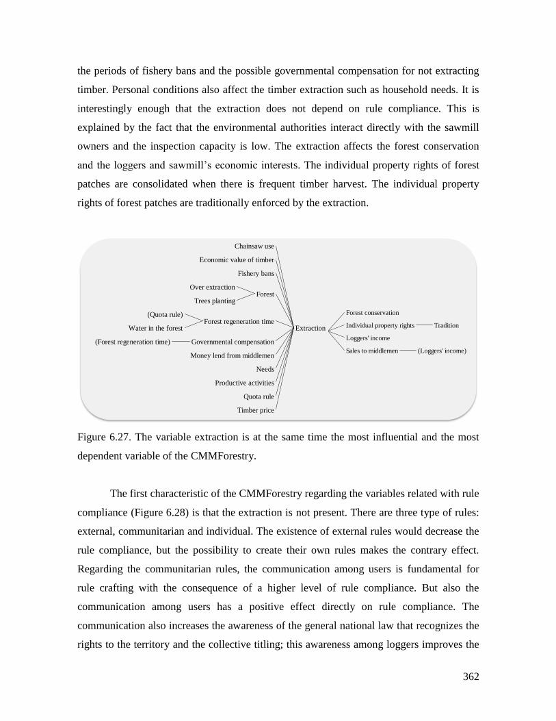
362
the periods of fishery bans and the possible governmental compensation for not extracting
timber. Personal conditions also affect the timber extraction such as household needs. It is
interestingly enough that the extraction does not depend on rule compliance. This is
explained by the fact that the environmental authorities interact directly with the sawmill
owners and the inspection capacity is low. The extraction affects the forest conservation
and the loggers and sawmill’s economic interests. The individual property rights of forest
patches are consolidated when there is frequent timber harvest. The individual property
rights of forest patches are traditionally enforced by the extraction.
Figure 6.27. The variable extraction is at the same time the most influential and the most
dependent variable of the CMMForestry.
The first characteristic of the CMMForestry regarding the variables related with rule
compliance (Figure 6.28) is that the extraction is not present. There are three type of rules:
external, communitarian and individual. The existence of external rules would decrease the
rule compliance, but the possibility to create their own rules makes the contrary effect.
Regarding the communitarian rules, the communication among users is fundamental for
rule crafting with the consequence of a higher level of rule compliance. But also the
communication among users has a positive effect directly on rule compliance. The
communication also increases the awareness of the general national law that recognizes the
rights to the territory and the collective titling; this awareness among loggers improves the
Extraction
Chainsaw use
Economic value of timber
Fishery bans
ForestOver extraction
Trees planting
Forest regeneration time(Quota rule)
Water in the forest
Governmental compensation(Forest regeneration time)
Money lend from middlemen
Needs
Productive activities
Quota rule
Timber price
Extraction
Forest conservation
Individual property rights Tradition
Loggers' income
Sales to middlemen (Loggers' income)
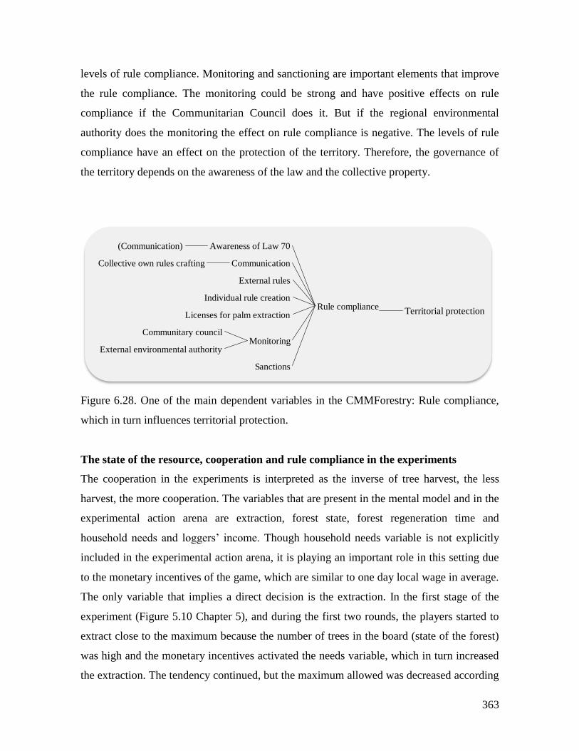
363
levels of rule compliance. Monitoring and sanctioning are important elements that improve
the rule compliance. The monitoring could be strong and have positive effects on rule
compliance if the Communitarian Council does it. But if the regional environmental
authority does the monitoring the effect on rule compliance is negative. The levels of rule
compliance have an effect on the protection of the territory. Therefore, the governance of
the territory depends on the awareness of the law and the collective property.
Figure 6.28. One of the main dependent variables in the CMMForestry: Rule compliance,
which in turn influences territorial protection.
The state of the resource, cooperation and rule compliance in the experiments
The cooperation in the experiments is interpreted as the inverse of tree harvest, the less
harvest, the more cooperation. The variables that are present in the mental model and in the
experimental action arena are extraction, forest state, forest regeneration time and
household needs and loggers’ income. Though household needs variable is not explicitly
included in the experimental action arena, it is playing an important role in this setting due
to the monetary incentives of the game, which are similar to one day local wage in average.
The only variable that implies a direct decision is the extraction. In the first stage of the
experiment (Figure 5.10 Chapter 5), and during the first two rounds, the players started to
extract close to the maximum because the number of trees in the board (state of the forest)
was high and the monetary incentives activated the needs variable, which in turn increased
the extraction. The tendency continued, but the maximum allowed was decreased according
Rule compliance
Awareness of Law 70(Communication)
CommunicationCollective own rules crafting
External rules
Individual rule creation
Licenses for palm extraction
MonitoringCommunitary council
External environmental authority
Sanctions
Rule compliance Territorial protection
364
to the state of the forest that was decreasing rapidly. According to the mental model, the
consequences of a high level of extraction are low forest conservation and high level of
loggers’ income. The forest conservation variable was not privileged due to the simplicity
of the experimental action arena and the short time horizon. Instead the household needs
variable was stronger than others.
The mental model also includes the variable quota rule, meaning that if a quota rule
exists the extraction decreases. In the second stage of the experiment when rules were in
place the extraction, in average, remained oscillating between 3 and two threes (Figure
5.10b, Chapter 5). Players could sustain this level of extraction across the ten rounds
because the resource state was enough high to allow this, which in turn was possible due to
some levels of rule compliance. According the mental model, rule compliance depends on
five variables that work in the experimental setting. They are communication, external
rules, individual rule creation, monitoring and sanctions. In the experiments the average
percentage of rule breaking was 48%. The communication increases the rule compliance,
but it was not allowed. The existence of external rules makes rule compliance decrease, in
the experiments the rules were externally perceived, therefore the percentage of rule
breaking increased. The mental model emphasizes the individual rule creation as a strong
cause in rule compliance increase. According to the mental model the monitoring and
sanctions increase the rule compliance. In the experiments the probability of monitoring
and sanctions was strong enough to increment the rule compliance to a level that allows
slowing the rate of resource decrease.
The state of the resource, cooperation and rule compliance in the Role Playing Game
(RPG)
In addition to the variables that conditioned the extraction in the experiments, in the RPG
(Section 5.3.3. Chapter 5) worked the timber price, the higher the price, and the higher the
extraction. The productive activities different from logging, the more possibility of
allocating effort to this activities such as agriculture and fishing, the less extraction. The use
of mechanized technologies to extract timber, such as the chainsaw, that permits to increase
the level of extraction. The existence of a rule that sets an extraction quota is a condition
that decreases the extraction. A governmental compensation aiming for not decrease the
365
extraction is also important. The money lending from middlemen to loggers is a definitive
condition for timber extraction. These variables were in place during the RPG. The loggers
in the RPG were of two types, one group declared that they used chainsaw and the others
used manual technologies. The first ones tried to allocate effort to fishing and agriculture
and the second allocated the effort to high levels of extraction. The timber price, which was
set by middlemen, and negotiated with loggers, played a fundamental role in the extraction
decisions. The timber extraction influences the state of the resource, the loggers’ income
that depends on the sales to the middlemen, and the property rights of the territory. In the
RPG was clear the creation of individual property rights of the forest as a function of the
level of extraction.
Regarding rule compliance in the RPG, the general regulation that was mentioned
has to do with the Law 7047. Most of the players discussed continuously about the territorial
protection and forest conservation as their main responsibility. One of the concrete rules
was about the prohibition of mangrove extraction for commercial use, rule that all the
players followed. In the mental model the awareness of Law 70 is one of the variables
determining the rule compliance. According the mental model the consequence of high
levels of rule compliance is the protection of the territory of the Communitarian Council.
The collective mental model and the behavioral spectrum
In the section 5.3.5 of Chapter 5 the behavioral spectrum of the typology of players is
discussed. The two types of players identified in this system are “Rule breakers by
necessity or convenience” and “Cheating players”. In the first category are the timber
loggers and the owners of sawmills (middlemen). And in the second category are the local
leaders. The mental model offers an explanation when some of the causal variables of
extraction and rule compliance are examined. When the level of household needs is high
for the loggers it is acceptable to change individually the rules (Table 5.16 Chapter 5). One
of the variables governing the extraction in the mental model is the need. But also this type
of behavior occurs when the middlemen demands timber under the minimum sizes that
formal environmental rules permit. In the mental model is explicit the timber price as driver
47 National Law that gives autonomy in territorial governance and collective land titling to the Communitarian
Councils in the Colombian Pacific region
366
of the extraction, which determines the middlemen demand. Rule compliance variable
depends on a variable called individual rule creation in the mental model. This is in tune
with one of the conditions of the type of behavior illustrated in Table 5.16 (Chapter 5): it is
acceptable for a person to change the rules. Regarding the behavior of the middlemen,
which justifies morally rule breaking in order to sustain their business. This is also
represented in the mental model in the positive relation between timber price and
extraction, and the importance of individual rule creation and the negative relation between
external rules and rule compliance. The justification for the rule breaking based on
necessity or convenience could be explained by the particular SES context. This is a high
level of UBN (68%) and also by the presence of timber price as driver of extraction and
rule compliance.
The second type of behavior; “Cheating player” is associated to local leaders, in the
sense that corruption is a very common problem among the Communitarian Council
ACAPA’s directive board members. The emphasis on individual rule creation and the
importance of the existence of local rules for high rule compliance could be part of the
explanation of this behavior.
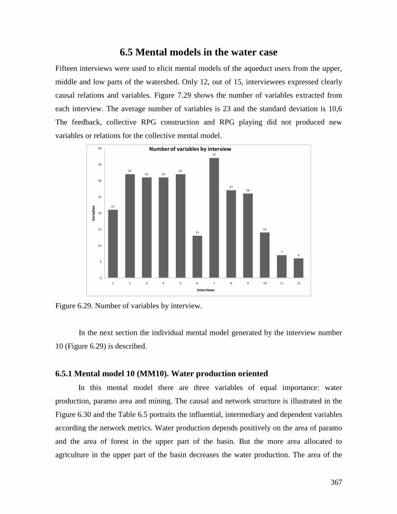
367
6.5 Mental models in the water case
Fifteen interviews were used to elicit mental models of the aqueduct users from the upper,
middle and low parts of the watershed. Only 12, out of 15, interviewees expressed clearly
causal relations and variables. Figure 7.29 shows the number of variables extracted from
each interview. The average number of variables is 23 and the standard deviation is 10,6
The feedback, collective RPG construction and RPG playing did not produced new
variables or relations for the collective mental model.
Figure 6.29. Number of variables by interview.
In the next section the individual mental model generated by the interview number
10 (Figure 6.29) is described.
6.5.1 Mental model 10 (MM10). Water production oriented
In this mental model there are three variables of equal importance: water
production, paramo area and mining. The causal and network structure is illustrated in the
Figure 6.30 and the Table 6.5 portraits the influential, intermediary and dependent variables
according the network metrics. Water production depends positively on the area of paramo
and the area of forest in the upper part of the basin. But the more area allocated to
agriculture in the upper part of the basin decreases the water production. The area of the
21
3231 31
32
13
37
2726
14
76
0
5
10
15
20
25
30
35
40
1 2 3 4 5 6 7 8 9 10 11 12
Va
ria
ble
s
Interviews
Number of variables by interview
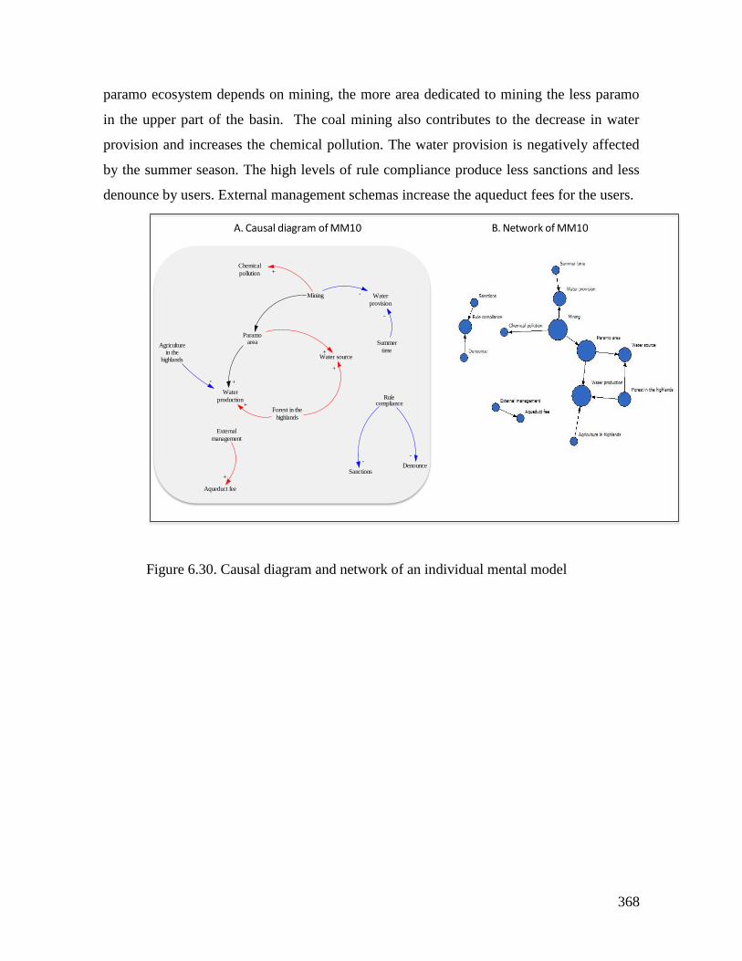
368
paramo ecosystem depends on mining, the more area dedicated to mining the less paramo
in the upper part of the basin. The coal mining also contributes to the decrease in water
provision and increases the chemical pollution. The water provision is negatively affected
by the summer season. The high levels of rule compliance produce less sanctions and less
denounce by users. External management schemas increase the aqueduct fees for the users.
Figure 6.30. Causal diagram and network of an individual mental model
Water
production
Agriculturein the
highlands
-
Paramoarea
+
Forest in the
highlands
+
Water source+
+
Chemical
pollution
Mining Water
provision
+
-
Summer
time
-
External
management
Aqueduct fee
+
Rulecompliance
DenounceSanctions
--
A. Causal diagram of MM10 B. Network of MM10
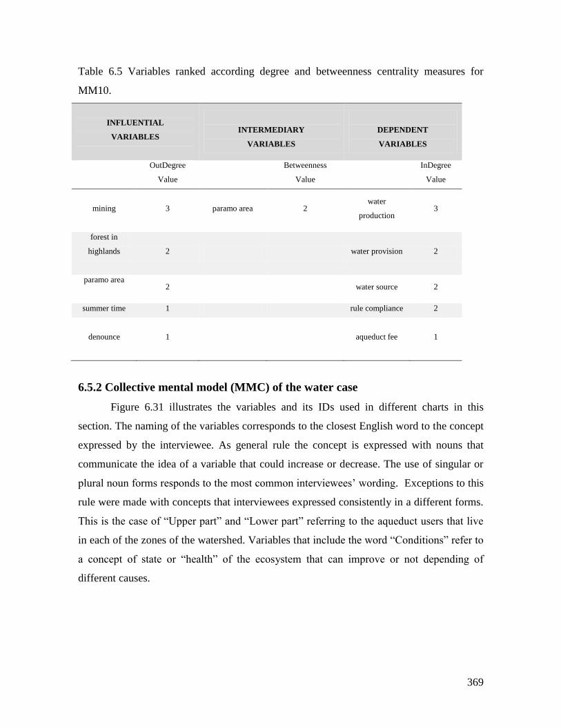
369
Table 6.5 Variables ranked according degree and betweenness centrality measures for
MM10.
INFLUENTIAL
VARIABLES
INTERMEDIARY
VARIABLES
DEPENDENT
VARIABLES
OutDegree
Value
Betweenness
Value
InDegree
Value
mining
3 paramo area 2 water
production 3
forest in
highlands
2 water provision 2
paramo area
2 water source 2
summer time 1 rule compliance 2
denounce 1
aqueduct fee
1
6.5.2 Collective mental model (MMC) of the water case
Figure 6.31 illustrates the variables and its IDs used in different charts in this
section. The naming of the variables corresponds to the closest English word to the concept
expressed by the interviewee. As general rule the concept is expressed with nouns that
communicate the idea of a variable that could increase or decrease. The use of singular or
plural noun forms responds to the most common interviewees’ wording. Exceptions to this
rule were made with concepts that interviewees expressed consistently in a different forms.
This is the case of “Upper part” and “Lower part” referring to the aqueduct users that live
in each of the zones of the watershed. Variables that include the word “Conditions” refer to
a concept of state or “health” of the ecosystem that can improve or not depending of
different causes.
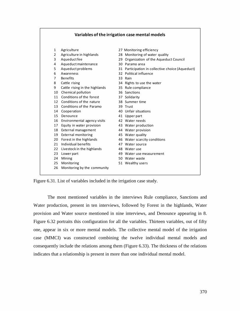
370
Figure 6.31. List of variables included in the irrigation case study.
The most mentioned variables in the interviews Rule compliance, Sanctions and
Water production, present in ten interviews, followed by Forest in the highlands, Water
provision and Water source mentioned in nine interviews, and Denounce appearing in 8.
Figure 6.32 portraits this configuration for all the variables. Thirteen variables, out of fifty
one, appear in six or more mental models. The collective mental model of the irrigation
case (MMCI) was constructed combining the twelve individual mental models and
consequently include the relations among them (Figure 6.33). The thickness of the relations
indicates that a relationship is present in more than one individual mental model.
1 Agriculture2 Agriculture in highlands3 Aqueduct fee4 Aqueduct maintenance5 Aqueduct problems6 Awareness7 Benefits8 Cattle rising9 Cattle rising in the highlands10 Chemical pollution11 Conditions of the forest12 Conditions of the nature13 Conditions of the Paramo14 Cooperation15 Denounce16 Environmental agency visits17 Equity in water provision18 External management19 External monitoring20 Forest in the highlands21 Individual benefits22 Livestock in the highlands23 Lower part24 Mining25 Monitoring26 Monitoring by the community
27 Monitoring efficiency28 Monitoring of water quality29 Organization of the Aqueduct Council30 Paramo area31 Participation in collective choice (Aqueduct)32 Political influence33 Rain34 Rights to use the water35 Rule compliance36 Sanctions37 Solidarity38 Summer time39 Trust40 Unfair situations41 Upper part42 Water needs43 Water production44 Water provision45 Water quality46 Water scarcity conditions47 Water source48 Water use49 Water use measurement50 Water waste51 Wealthy users
Variables of the irrigation case mental models
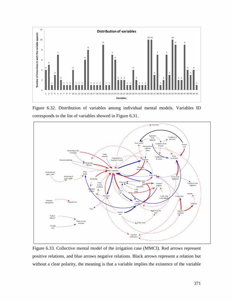
371
Figure 6.32. Distribution of variables among individual mental models. Variables ID
corresponds to the list of variables showed in Figure 6.31.
Figure 6.33. Collective mental model of the irrigation case (MMCI). Red arrows represent
positive relations, and blue arrows negative relations. Black arrows represent a relation but
without a clear polarity, the meaning is that a variable implies the existence of the variable
4
5
1
3
7
2
1 1 1
4
1 1 1
6
8
1 1 1 1
9
1 1
7
6
2 2 2
1 1
4
2
1 1 1
10 10
3
7
1
2
7
3
10
9
2 2
9
4
3
4
1
0
2
4
6
8
10
12
1 2 3 4 5 6 7 8 9 10 11 12 13 14 15 16 17 18 19 20 21 22 23 24 25 26 27 28 29 30 31 32 33 34 35 36 37 38 39 40 41 42 43 44 45 46 47 48 49 50 51
Nu
mb
er o
f in
terv
iew
s in
wic
h t
he
vari
able
ap
pea
rs
Variables
Distribution of variables
Organization of
Aqueduct Council
Awareness
Sanctions
+
+
Water source
Water waste
Upperpart
+
+
Water use
measurement
-
Rule compliance
Monitoring
Lower
part
Water use
-+
+
-
+
Forest in the
Highlamds
Water
production
Livestock in the
highlands
-
Denounce
Aqueduct
maintenance
+
Water needs
Right to use the
water+
+
Water
scarcity
conditions
+
Individual
benefits
+
+
Summer
time
+
Water
provision
+
-
Cooperation
-
+
Aqueduct
problems
+
Participation in
collective
choice
-
Agriculture
in the
highlands
-Conditions of the
Paramo
-
Conditions of
the nature
++
Conditions of
the forest
+
Mining
-
Unfair
situations
-
-
-
+
-
+
+
-
+
Monitoring
efficiency
+
Water
quality
+
Monitoring of
water quality
+
External monitoring
+
Monitoring by the
community
-
Environmental
agency visits
+
-
+
+
+
Agriculture
Cattle
rising
Solidarity
+
Benefits
+
Paramo
area
+
Trust
-
+
+
+
Chemical
pollution+
-
Cattle rising
in the higlands
+
-
+
++
-
+
-Extyernal
management Aqueduct fee+
+
Wealthy
users
Equity in water
provision-
Political
influence
-
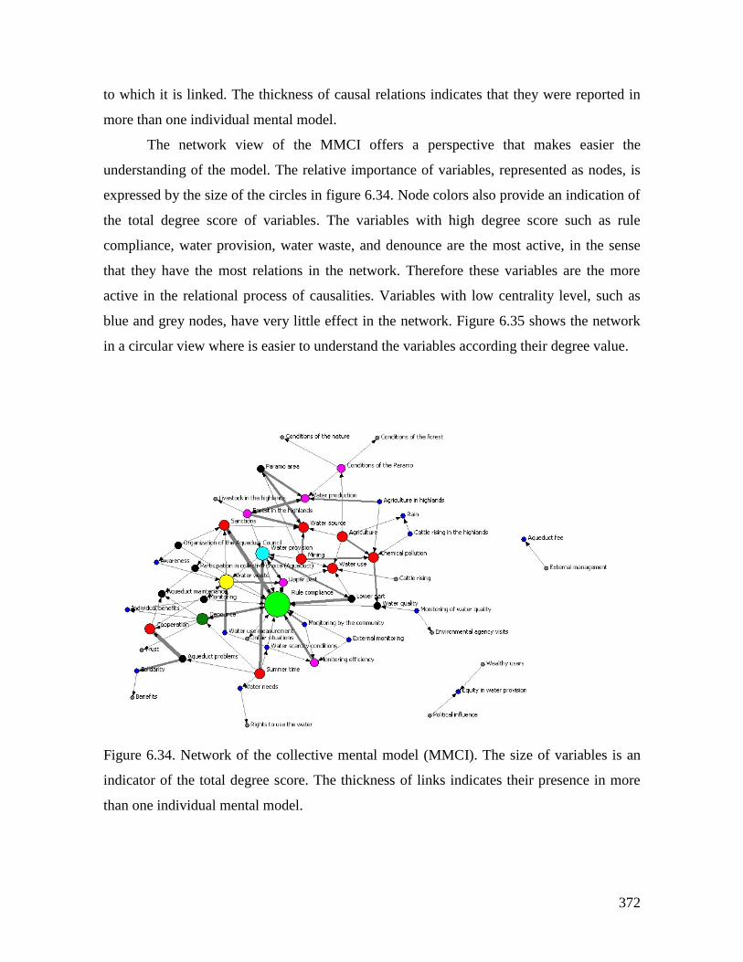
372
to which it is linked. The thickness of causal relations indicates that they were reported in
more than one individual mental model.
The network view of the MMCI offers a perspective that makes easier the
understanding of the model. The relative importance of variables, represented as nodes, is
expressed by the size of the circles in figure 6.34. Node colors also provide an indication of
the total degree score of variables. The variables with high degree score such as rule
compliance, water provision, water waste, and denounce are the most active, in the sense
that they have the most relations in the network. Therefore these variables are the more
active in the relational process of causalities. Variables with low centrality level, such as
blue and grey nodes, have very little effect in the network. Figure 6.35 shows the network
in a circular view where is easier to understand the variables according their degree value.
Figure 6.34. Network of the collective mental model (MMCI). The size of variables is an
indicator of the total degree score. The thickness of links indicates their presence in more
than one individual mental model.
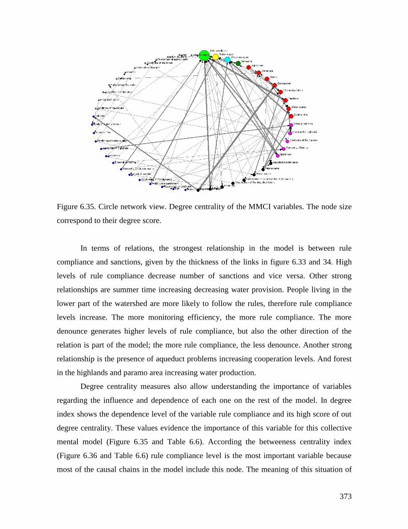
373
Figure 6.35. Circle network view. Degree centrality of the MMCI variables. The node size
correspond to their degree score.
In terms of relations, the strongest relationship in the model is between rule
compliance and sanctions, given by the thickness of the links in figure 6.33 and 34. High
levels of rule compliance decrease number of sanctions and vice versa. Other strong
relationships are summer time increasing decreasing water provision. People living in the
lower part of the watershed are more likely to follow the rules, therefore rule compliance
levels increase. The more monitoring efficiency, the more rule compliance. The more
denounce generates higher levels of rule compliance, but also the other direction of the
relation is part of the model; the more rule compliance, the less denounce. Another strong
relationship is the presence of aqueduct problems increasing cooperation levels. And forest
in the highlands and paramo area increasing water production.
Degree centrality measures also allow understanding the importance of variables
regarding the influence and dependence of each one on the rest of the model. In degree
index shows the dependence level of the variable rule compliance and its high score of out
degree centrality. These values evidence the importance of this variable for this collective
mental model (Figure 6.35 and Table 6.6). According the betweeness centrality index
(Figure 6.36 and Table 6.6) rule compliance level is the most important variable because
most of the causal chains in the model include this node. The meaning of this situation of
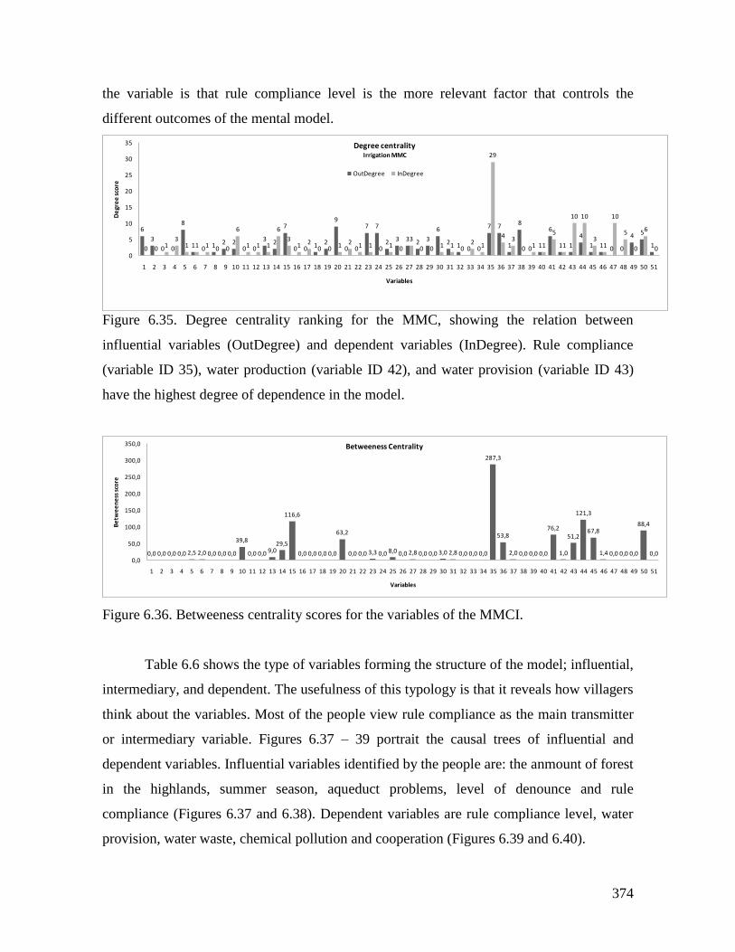
374
the variable is that rule compliance level is the more relevant factor that controls the
different outcomes of the mental model.
Figure 6.35. Degree centrality ranking for the MMC, showing the relation between
influential variables (OutDegree) and dependent variables (InDegree). Rule compliance
(variable ID 35), water production (variable ID 42), and water provision (variable ID 43)
have the highest degree of dependence in the model.
Figure 6.36. Betweeness centrality scores for the variables of the MMCI.
Table 6.6 shows the type of variables forming the structure of the model; influential,
intermediary, and dependent. The usefulness of this typology is that it reveals how villagers
think about the variables. Most of the people view rule compliance as the main transmitter
or intermediary variable. Figures 6.37 – 39 portrait the causal trees of influential and
dependent variables. Influential variables identified by the people are: the anmount of forest
in the highlands, summer season, aqueduct problems, level of denounce and rule
compliance (Figures 6.37 and 6.38). Dependent variables are rule compliance level, water
provision, water waste, chemical pollution and cooperation (Figures 6.39 and 6.40).
6
3
0 0
8
1 0 1 2 20 0
3 2
7
0 0 1 2
9
0 0
7 7
2 3 3 2 3
6
2 1 0 0
7 7
1
8
0 1
6
1 1
4
1 1 0 0
4 5
10 0 13
1 1 1 0 0
6
1 1 1
6
31 2
0 0 1 2 1 1 0 1 0
3
0 0 1 1 02 1
29
4 3
0 1 1
5
1
10 10
31
10
5
0
6
00
5
10
15
20
25
30
35
1 2 3 4 5 6 7 8 9 10 11 12 13 14 15 16 17 18 19 20 21 22 23 24 25 26 27 28 29 30 31 32 33 34 35 36 37 38 39 40 41 42 43 44 45 46 47 48 49 50 51
De
gre
e s
core
Variables
Degree centralityIrrigation MMC
OutDegree InDegree
0,0 0,0 0,0 0,0 2,5 2,0 0,0 0,0 0,0
39,8
0,0 0,0 9,029,5
116,6
0,0 0,0 0,0 0,0
63,2
0,0 0,0 3,3 0,0 8,0 0,0 2,8 0,0 0,0 3,0 2,8 0,0 0,0 0,0
287,3
53,8
2,0 0,0 0,0 0,0
76,2
1,0
51,2
121,3
67,8
1,4 0,0 0,0 0,0
88,4
0,00,0
50,0
100,0
150,0
200,0
250,0
300,0
350,0
1 2 3 4 5 6 7 8 9 10 11 12 13 14 15 16 17 18 19 20 21 22 23 24 25 26 27 28 29 30 31 32 33 34 35 36 37 38 39 40 41 42 43 44 45 46 47 48 49 50 51
Be
twe
en
ess
sco
re
Variables
Betweeness Centrality
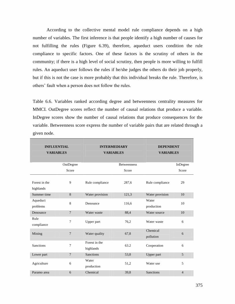
375
According to the collective mental model rule compliance depends on a high
number of variables. The first inference is that people identify a high number of causes for
not fulfilling the rules (Figure 6.39), therefore, aqueduct users condition the rule
compliance to specific factors. One of these factors is the scrutiny of others in the
community; if there is a high level of social scrutiny, then people is more willing to fulfill
rules. An aqueduct user follows the rules if he/she judges the others do their job properly,
but if this is not the case is more probably that this individual breaks the rule. Therefore, is
others’ fault when a person does not follow the rules.
Table 6.6. Variables ranked according degree and betweenness centrality measures for
MMCI. OutDegree scores reflect the number of causal relations that produce a variable.
InDegree scores show the number of causal relations that produce consequences for the
variable. Betweenness score express the number of variable pairs that are related through a
given node.
INFLUENTIAL
VARIABLES
INTERMEDIARY
VARIABLES
DEPENDENT
VARIABLES
OutDegree
Score
Betweenness
Score
InDegree
Score
Forest in the
highlands
9 Rule compliance 287,6 Rule compliance 29
Summer time 8 Water provision 121,3 Water provision 10
Aqueduct
problems 8 Denounce 116,6
Water
production 10
Denounce 7 Water waste 88,4 Water source 10
Rule
compliance 7 Upper part 76,2 Water waste 6
Mining 7 Water quality 67,8 Chemical
pollution 6
Sanctions 7 Forest in the
highlands 63.2 Cooperation 6
Lower part 7 Sanctions 53,8 Upper part 5
Agriculture 6 Water
production 51,2 Water use 5
Paramo area 6 Chemical 39,8 Sanctions 4
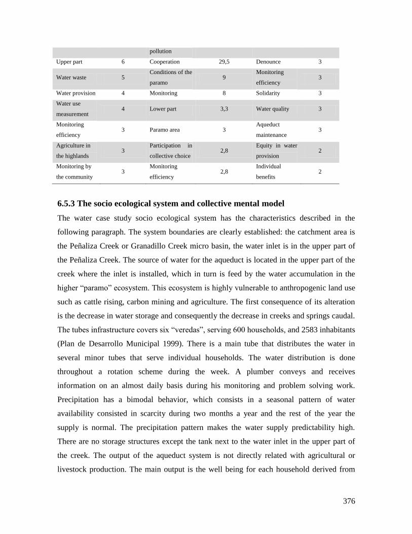
376
pollution
Upper part 6 Cooperation 29,5 Denounce 3
Water waste 5 Conditions of the
paramo 9
Monitoring
efficiency 3
Water provision 4 Monitoring 8 Solidarity 3
Water use
measurement 4 Lower part 3,3 Water quality 3
Monitoring
efficiency 3 Paramo area 3
Aqueduct
maintenance 3
Agriculture in
the highlands 3
Participation in
collective choice 2,8
Equity in water
provision 2
Monitoring by
the community 3
Monitoring
efficiency 2,8
Individual
benefits 2
6.5.3 The socio ecological system and collective mental model
The water case study socio ecological system has the characteristics described in the
following paragraph. The system boundaries are clearly established: the catchment area is
the Peñaliza Creek or Granadillo Creek micro basin, the water inlet is in the upper part of
the Peñaliza Creek. The source of water for the aqueduct is located in the upper part of the
creek where the inlet is installed, which in turn is feed by the water accumulation in the
higher “paramo” ecosystem. This ecosystem is highly vulnerable to anthropogenic land use
such as cattle rising, carbon mining and agriculture. The first consequence of its alteration
is the decrease in water storage and consequently the decrease in creeks and springs caudal.
The tubes infrastructure covers six “veredas”, serving 600 households, and 2583 inhabitants
(Plan de Desarrollo Municipal 1999). There is a main tube that distributes the water in
several minor tubes that serve individual households. The water distribution is done
throughout a rotation scheme during the week. A plumber conveys and receives
information on an almost daily basis during his monitoring and problem solving work.
Precipitation has a bimodal behavior, which consists in a seasonal pattern of water
availability consisted in scarcity during two months a year and the rest of the year the
supply is normal. The precipitation pattern makes the water supply predictability high.
There are no storage structures except the tank next to the water inlet in the upper part of
the creek. The output of the aqueduct system is not directly related with agricultural or
livestock production. The main output is the well being for each household derived from
377
receiving water regularly directly in the house mainly for domestic use. The governing
organization of the system is a communal association which members are all the users. The
aqueduct infrastructure is owned by the communal association; it is a common resource.
The aqueduct has a set of formal rules at the three levels: operational, collective choice and
constitutional. Monitoring and sanctioning processes are carried out by members of the
General Assembly and the plumber. In the rural zone of the Municipality of Lenguazaque,
where the aqueduct system is located, the UBM indicator is 36.4%. Land tenure trend in the
rural zone of the Municipality can be an indicator of land property in the zone covered by
the aqueduct system. Seventy six percent (76%) of the owners of rural land own areas
ranging between 0.5 and 5 Ha. The most probable trend is that properties will be less than
10 hectares in the short term. In terms of stability of the population, there are no data on
population mobility, but from interviews, one can conclude that there is a tendency of
young people to migrate to bigger cities. Before the aqueduct construction, in 1995, people
had to go to the creek and manually transport water to their homes. A milestone in the
decision for the organization of the aqueduct was a strong drought about 20 years ago and
several episodes of water contamination because of carbon mining. As a consequence,
leaders of the “veredas” gathered and decided to manage to build an aqueduct. Users of the
aqueduct invest in the system throughout the quota every two months. These contributions
are used to maintain infrastructure and pay the salary of the plumber. Conflicts arise
occasionally when some users stock water and the aqueduct council does not intervene, or
in cases that users try to appropriate water illegally. Lobbying activities with local and
regional politics is important because is the form of acquire public resources for
infrastructure maintaining or buying small land patches in the upper part of the watershed
for springs conservation. The general assembly gathers once per semester, but also,
occasionally users gather to plant trees or fix fences of communal land patches bought for
springs conservation.
The collective mental model conveys a particular perspective of the important
aspects (variables), for the users, and causal mechanisms regarding the water and aqueduct
use and management. There are three main influential variables that condition several
variables of the SES. The first is the existence and area of forest in the upper parts of the
watershed that affects the water production and provision, but also the presence of livestock
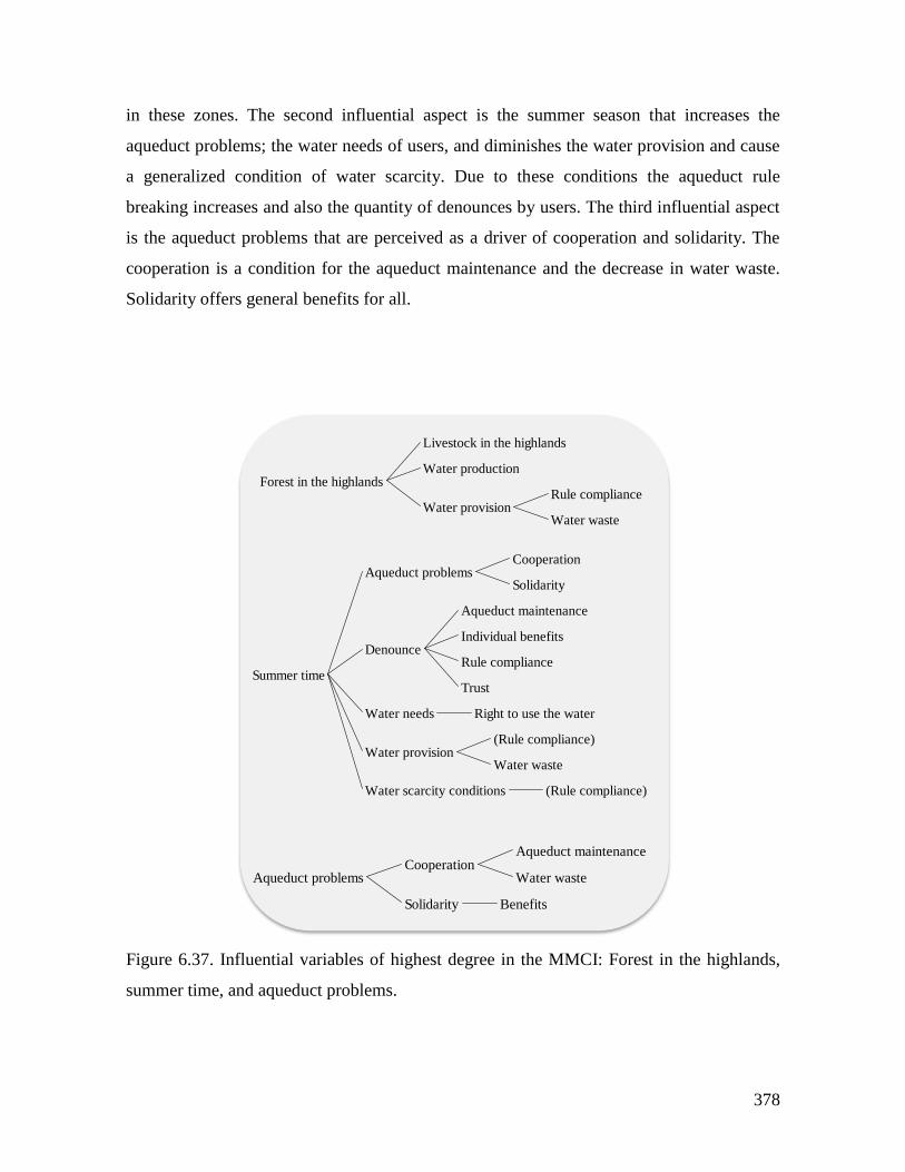
378
in these zones. The second influential aspect is the summer season that increases the
aqueduct problems; the water needs of users, and diminishes the water provision and cause
a generalized condition of water scarcity. Due to these conditions the aqueduct rule
breaking increases and also the quantity of denounces by users. The third influential aspect
is the aqueduct problems that are perceived as a driver of cooperation and solidarity. The
cooperation is a condition for the aqueduct maintenance and the decrease in water waste.
Solidarity offers general benefits for all.
Figure 6.37. Influential variables of highest degree in the MMCI: Forest in the highlands,
summer time, and aqueduct problems.
Forest in the highlands
Livestock in the highlands
Water production
Water provisionRule compliance
Water waste
Summer time
Aqueduct problemsCooperation
Solidarity
Denounce
Aqueduct maintenance
Individual benefits
Rule compliance
Trust
Water needs Right to use the water
Water provision(Rule compliance)
Water waste
Water scarcity conditions (Rule compliance)
Aqueduct problemsCooperation
Aqueduct maintenance
Water waste
Solidarity Benefits
379
Rule compliance has a high importance in this collective mental model. The
variables that condition that people follow the aqueduct rules belong to four types. The first
has to do with monitoring and sectioning. In general, the perspective is that any type of
monitoring increases the rule compliance, but if the monitoring is done by agencies external
to the community, the efficiency is higher than a monitoring carried out by the community.
Additionally the existence of sanctions increases the rule compliance. The second set of
variables inform about the relation between the geographical location in the watershed and
rule compliance. People living in the upper part of the basing tend to follow less the rules,
in contrast with the lower part where the rule compliance is higher. This is reflected in the
results of the water experiment (Chapter 5). When the rotation rule is used, which is similar
to what is happening in the SES for water distribution there was not rule breaking in
contrast with the quota rule that produced 18% of rule breaking. The third set of factors
affecting the rule compliance is related with the collective choice arena. The more
organized the aqueduct council, the higher the levels of rule compliance, and the more
opportunities to participate in the administration of the aqueduct, the better the rule
compliance. The fourth group of factors is related with the resource. Water quality affects
the rule compliance positively, but the scarcity creates incentives to break the rules. The
assurance of water provision decreases the possibility that users break the rules. And the
water wasting by other users discourages people to follow the rules. When rule compliance
improves denounces and sanctions decrease and the conflicts among users also.

380
Figure 6.38. Dependent variables of highest degree in MMC: rule compliance.
The variables more dependent in the CMM are water provision, water waste,
chemical pollution, and cooperation. The factors that affect positively the water provision
are the presence of forest in the upper part of the basin and the behavior of people located
in the lower part. In the water experiment (Chapter 5) when rotation rule where in place, the
contribution to water provision of players located at the end of the channel (lower part of
the basin) increased 60% of the cooperation equilibrium, above contributions of the A and
B players. And the negative effects are due to the mining activities, summer seasons and
the behavior of people from the upper zones of the watershed. The water waste is
something that depends of the awareness level of users, the levels of cooperation and the
Rule compliance
Denounce(Rule compliance)
Summer time
External monitoring
Lower part
Monitoring
Monitoring by the community
Monitoring efficiency
(External monitoring)
(Monitoring by the community)
Water use measurement
Organization of Aqueduct Council
Participation in collective choice
Sanctions
(Organization of Aqueduct Council)
(Participation in collective choice)
(Rule compliance)
(Water waste)
Unfair situations
Upper part
Water provision
Forest in the highlands
(Lower part)
Mining
(Summer time)
(Upper part)
Water qualityChemical pollution
Monitoring of water quality
Water scarcity conditions(Summer time)
Water waste
Awareness
Cooperation
(Upper part)
(Water provision)
(Water use measurement)
Rule compliance
Denounce
Aqueduct maintenance
Individual benefits
(Rule compliance)
Trust
Sanctions(Rule compliance)
Water source
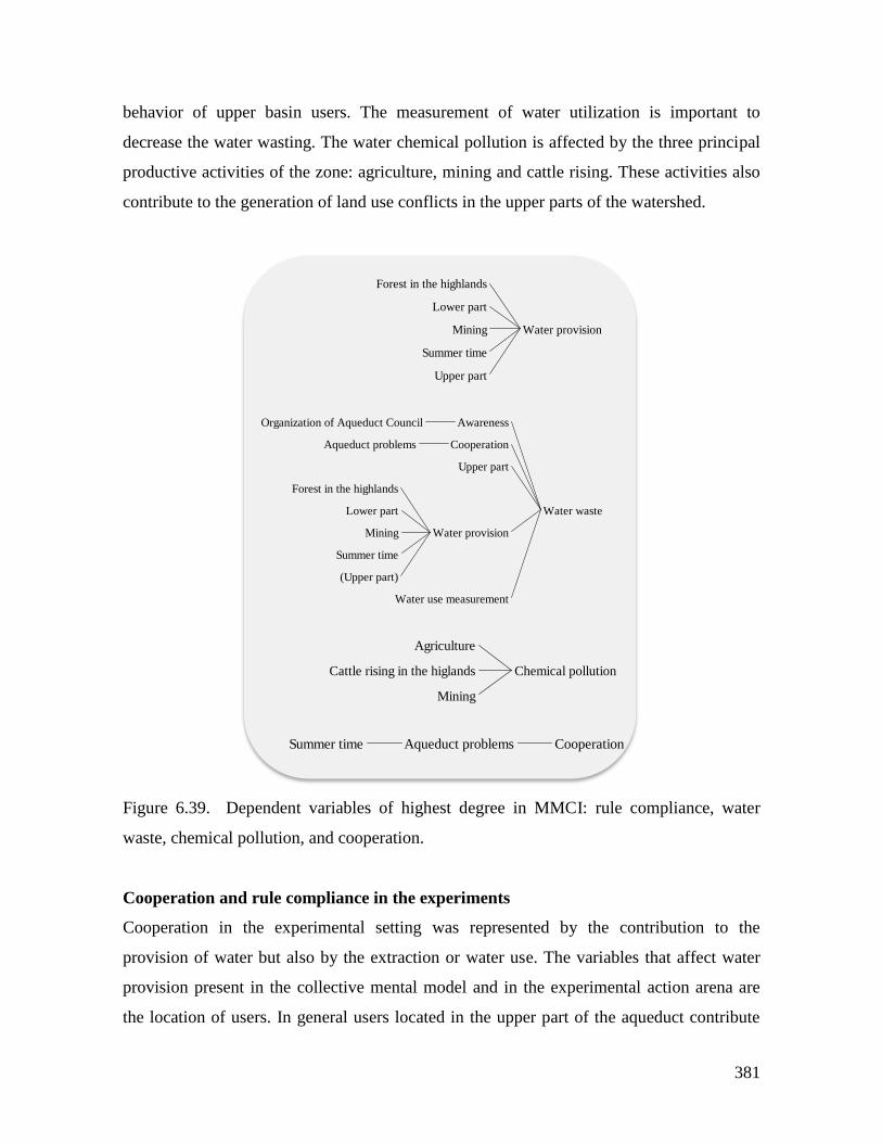
381
behavior of upper basin users. The measurement of water utilization is important to
decrease the water wasting. The water chemical pollution is affected by the three principal
productive activities of the zone: agriculture, mining and cattle rising. These activities also
contribute to the generation of land use conflicts in the upper parts of the watershed.
Figure 6.39. Dependent variables of highest degree in MMCI: rule compliance, water
waste, chemical pollution, and cooperation.
Cooperation and rule compliance in the experiments
Cooperation in the experimental setting was represented by the contribution to the
provision of water but also by the extraction or water use. The variables that affect water
provision present in the collective mental model and in the experimental action arena are
the location of users. In general users located in the upper part of the aqueduct contribute
Water provision
Forest in the highlands
Lower part
Mining
Summer time
Upper part
Water waste
AwarenessOrganization of Aqueduct Council
CooperationAqueduct problems
Upper part
Water provision
Forest in the highlands
Lower part
Mining
Summer time
(Upper part)
Water use measurement
Chemical pollution
Agriculture
Cattle rising in the higlands
Mining
CooperationAqueduct problemsSummer time
382
more to water provision, while users of the lower part contribute less. In the experiments
players located in the upper part (players in position A and B) contributed more than the
rest during the first stage of the experiments when there were no rules working (Figure 5.18
Chapter 5). The water use depends, in the mental model, of several variables, but in the
experimental action arena only the location (upper and lower part location). The effect on
water use is contrary to the effect on water provision. Users located in the upper part tend to
use more water than users in the lower part. In the experiment (Figure 5.19 Chapter 5) this
is the behavior of players across the channel regarding water extraction.
The mental model’s variables that affect the rule compliance and that are present in
the experimental action arena are location, external monitoring, monitoring by the
community, monitoring efficiency, sanctions, unfair situations and water provision. When
the rule of property rights was in place the rule breaking was relatively low (18%) (Table
5.18 Chapter 5). The variables sanctions, monitoring and water provision are the most
influencing in the rule compliance level that, in turn made the water extraction to be more
evenly distributed across the channel (Figure 5.19d Chapter 5).
Water provision, cooperation and rule compliance in the Role Playing Game (RPG
In the RPG of the aqueduct the main outcomes can be synthetized as follows. The players
of the upper part of the basin accumulated mainly water, while players in the lower part
accumulated money instead of water. The Aqueduct Council accumulated money but did
not invested in forest for water provision. All the players were focused on developing their
own strategies independently of the formal rules. The variables of the mental model that
influences rule compliance such as monitoring, sanctions and organization of the Aqueduct
Council have low levels that, in turn produced low levels of rule compliance. Now the
water provision, in addition to location in the basin, included the variable forest in the
highlands, which was increased only by the players located in the upper part of the basin.
The collective mental model and the behavioral spectrum
The typology of players identified for this case includes “Rule breakers by conviction” and
“Cheating players” (Thable 5.25 Chapter 5). To the first category belong the most part of
the aqueduct users, and to the second the wealthier users of the aqueduct. In this case rule
383
breaking by conviction is linked to the adaptation to external power requirements in order
to obtain own objectives. These objectives are focused in the satisfaction of household
needs. The mechanisms to reach them are several. The historical behavior according what
the formal rules and agreements are accepted in the discourse, but in practice the behavior
deviates from that. The reciprocity rule for the interactions with external actors is
fundamental for reaching their objectives. In the mental model there are elements that
permit explaining this behavior in terms of causal structures regarding rule compliance
(Section 5.4.5 Chapter 5). Regarding the monitoring and sanctions variables that affect rule
compliance it is important to remark variables that have a negative relation with rule
compliance. This if the variable level increases the rule compliance decreases. These are
the existence of unfair situations in the use of water, monitoring and sanctioning, and
external monitoring. Regarding the location, the persons that live in the upper part also
have a negative relation with rule compliance. The second category of behavior, “Cheating
player”, is characteristic of wealthier users that gets more water. In the mental model this
explicitly represented by the relation between unfair situations and rule compliance, not
only by the offender but also the situation generates low rule compliance in the rest o users.
In general it is possible to infer from the mental model that the resource is a public
good and a common good. The water is a right and there is not so much emphasis in water
scarcity only in the summer season when following the rules is more difficult. The
emphasis is more in the water waste as a lack of community awareness. The provision of
the resource depends on variables that the users consider external or out of their control
such as mining, forest areas and chemical pollution. To follow the rules in this system does
not implies a big effort and it has not to do directly with improve or not their monetary
income, it is related with the increase in their well being.
6.6 Conclusions
The variables rule compliance; resource state and extraction illustrate relevant findings of
the mental models study. Table 6.7 shows the total degree score of each variable for each
case. This is the total number of relations that includes the variable, which gives a proxy of
the importance of the variable in the collective mental model. Rule compliance has a high
value in the water case compared with the other two cases. This could be linked to the

384
successful management of the communitarian aqueduct. For the fishery case, rule
compliance has less importance reflecting that the central point is the inequality of rule
enforcement. The forestry case shows the lower importance for rule compliance. This is
according to the main characteristics of this system: forest use and management
subordinated to the market rules, high levels of corruption and unsatisfied basic needs
(UBN).
Regarding the resource, in the fishery the variable has the highest value reflecting
the importance of the activity and the awareness of its importance. In the forestry and water
the resource variable is not as important as in the fishery. The extraction variable is of high
importance in the forestry case, users are economically highly dependent on it and it is the
driver of the timber market.
The convergence of mental models has been proposed as one of the factors that
affect the potential for self-organization in CPR management (Poteete et al, 2010). This is,
the higher the level of homogeneity in the mental models in a group of individuals in a CPR
situation, the higher the possibilities that they could develop institutional arrangements for
a successful CPR management. Inspired by this idea a simple indicator of homogeneity was
developed for the three case studies. Based on the interviews that generated the mental
models for each case, a comparison between the total numbers of variables present in the
collective mental model, and the number of variables included in each individual mental
model was done. This calculation gives an indicator of similarity, in number of variables,
between the individual and the collective mental model. Therefore, if the indicator has a
value of 1, it means that the individual mental model has the same number of variables that
the collective one. On the contrary if the value is close to 0 the individual mental model has
very few variables. This indicator was calculated for each individual mental model and then
the average of this value for each case was calculated.
The value for the fishery case was 0,35; the forestry case gave a figure of 0,11 and
the water case a score of 0,45. The interpretation of this indicator is that the in the aqueduct
system the level of homogeneity is considerably higher than in the other cases. This could
reflect the success of the self-organization of the communitarian aqueduct (15 years), and
also can be confirmed by the high importance of the rule compliance variable in the
collective mental model (Table 6.7). The forestry case has a low homogeneity score, which
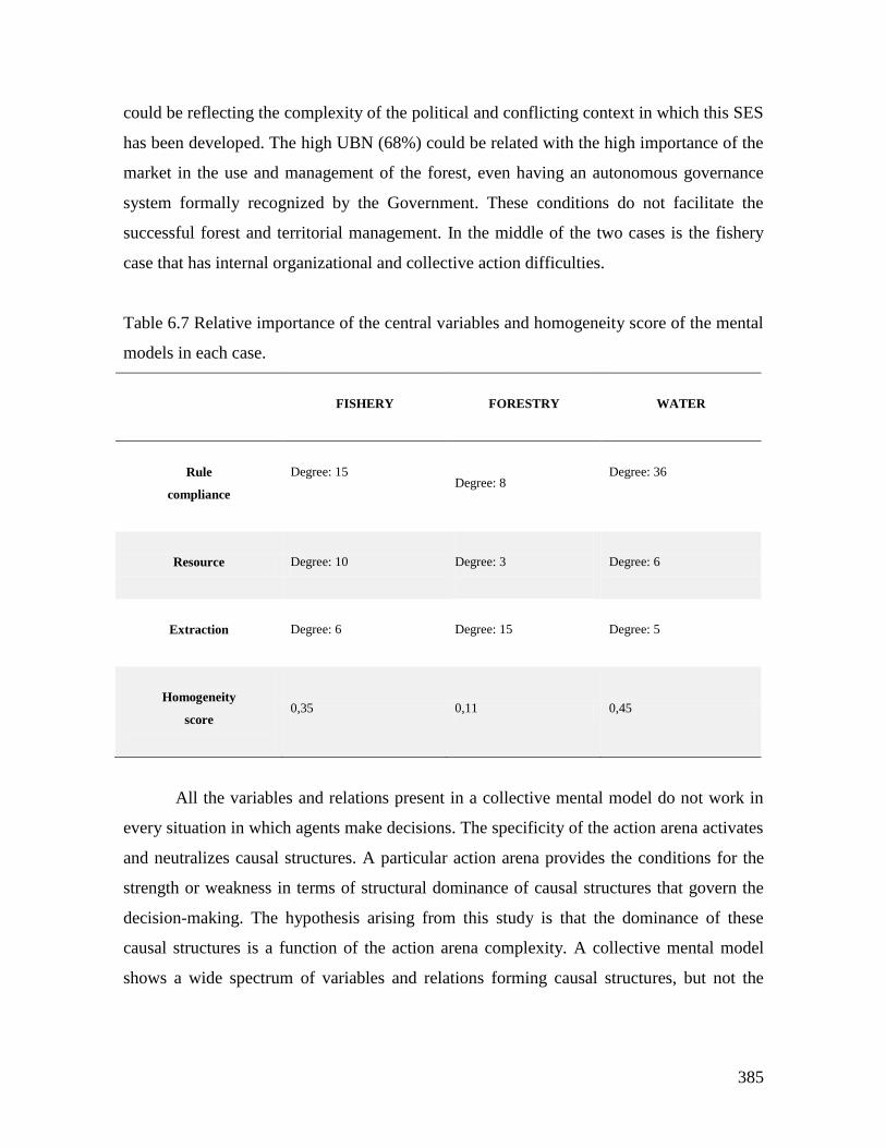
385
could be reflecting the complexity of the political and conflicting context in which this SES
has been developed. The high UBN (68%) could be related with the high importance of the
market in the use and management of the forest, even having an autonomous governance
system formally recognized by the Government. These conditions do not facilitate the
successful forest and territorial management. In the middle of the two cases is the fishery
case that has internal organizational and collective action difficulties.
Table 6.7 Relative importance of the central variables and homogeneity score of the mental
models in each case.
FISHERY
FORESTRY WATER
Rule
compliance
Degree: 15
Degree: 8
Degree: 36
Resource Degree: 10
Degree: 3
Degree: 6
Extraction
Degree: 6 Degree: 15 Degree: 5
Homogeneity
score
0,35 0,11 0,45
All the variables and relations present in a collective mental model do not work in
every situation in which agents make decisions. The specificity of the action arena activates
and neutralizes causal structures. A particular action arena provides the conditions for the
strength or weakness in terms of structural dominance of causal structures that govern the
decision-making. The hypothesis arising from this study is that the dominance of these
causal structures is a function of the action arena complexity. A collective mental model
shows a wide spectrum of variables and relations forming causal structures, but not the

386
entire model is used in the actors’ decisions in a given action arena and in a specific realm,
in this case common resources use and management.
387
7. DISCUSSION
The goal of the dissertation was to study the link between CPR management, mental
models and institutions. I intended to address the cognitive problem underlying common
pool resources dilemmas in social ecological systems. I developed this research from the
perspective according that natural resources management must include the understanding of
human systems relations, human values and cultural conceptions. The hypothesis driving
this research was that the actors involved in a CPR dilemma could have a different
understanding of the commons problem in contrast with the common assumptions
according that there is a relative high level of homogeneity among actors in the
understanding of CPR dilemmas. This perspective has had consequences in terms of
frequent policy failures discussed in the Chapter 1. The definition of problems in natural
resources management is fundamental for policy design, but an appropriate problem
definition depends on the effort for understanding the different types of knowledge and
world visions of actors involved. Heterogeneity of actor’s interests, values and priorities are
the superficial expressions of deep structured visions of the world. In order to explore this
problem I studied three case studies in Colombia, where CPR are central for the
communities. The CPR in these cases are fisheries, water and forestry resources. I intended
to link the local context, institutional arrangements and mental models in order to explain
decision making of resource users. The general research question was: what are the
relations between mental model of resource users and the institutional landscape and
ecological context they face?
In this final chapter I first offer a brief overview of the results of the conceptual
framework discussion of Chapter 2. I start by reviewing the lessons from the institutional
analysis. I particularly want to focus on the general morality conformance outcome of the
action arena. I make a discussion about the methodological lessons of the research for the
study of SES. In the next section I discuss the main lessons of the methodological approach
used in this dissertation. Finally I close the chapter with the main insight from the research.
388
7.1 The behavioral outcomes of the action arena
In the conceptual state of the art (Chapter 2) I developed a conceptual integration of the
theoretical elements that constitutes the behavior possibilities of CPR users as outcomes of
an action arena (Figure 2.15 Chapter 2). The proposal is that the ultimate behavioral
outcomes in an action arena have, on one hand, specific cooperation and trust levels, and on
the other hand, a specific behavior of CPR users regarding the level and reasons of rule
compliance. This behavioral spectrum includes rule breakers by conviction, by necessity or
convenience and cheating players . These ultimate behavioral outcomes are consequence of
another type of results: 1) which are the mental models, that are context dependent
constructs, and 2) a morality conformance system. In this structure the institutional
arrangements are shaped, on one side, by the mental models, and on the other side by the
moral system, which in turn is conditioned by cooperation and trust levels and the
behavioral spectrum. The institutional arrangements are also affected by this moral system,
and more directly the norms, endogenous rules and agreements.
In the next two sections, first I consider the main lessons from the institutional
analysis. And secondly, I discuss how the conceptual framework mentioned above worked
to study the relation among institutions and mental models. It is important to remark that in
the path to study this relation, I found that a fundamental dimension that was missing in the
initial approach of this research was the moral system, which I consider that is one of the
most important lessons from the study.
7.1.1 Lessons from the institutional analysis
Cooperation and trust levels are important behavioral outcomes of the action arena in CPR
dilemmas. The data used to understand cooperation and trust variables were obtained from
economic experiments, role playing games (RPG) and surveys and interviews. In the three
SESs cooperation has different forms and drivers. The definitions of trust and cooperation
are varied in the literature depending on the field and even an author could change his
notion depending on the type of problem addressed. For Luhmann (1982) trust is the
starting point for rule crafting in order to shape individual behavior. In this sense the trust
has the function of diminish the levels of social complexity. For the author trust is the most
effective way of diminish social complexity, and in this form appear more action
389
possibilities and less uncertainty regarding the outcomes. For experimentalists trust is
conceptualized as the support of cooperation, and trust has been defined as the “cognitive
belief that others will positively reciprocate one`s willingness to take a risk” (Levi, 2003:
379), or the “willingness to take some risk in relation to other individuals on the
expectation that the others will reciprocate” (Ostrom & Walker, 2003: 382). Users of the
three case studies investigated in this research seem to have similar notions of trust.
However the findings of this research are consistent with other studies in the sense that
trustworthiness levels have a big variability across cultures and across groups (Henrich
et al., 2001; Henrich, 2004). In the three SESs studied trust rests on particular moral
systems that produce the variability mentioned by Henrich and colleagues.
Cooperation, as a product of trust, is the final result of behavior. As I have
discussed in chapter 2, in line with Nowak (2006) and Nowak & Sigmund (1998),
cooperation entails five mechanisms (familiar selection, direct reciprocity, indirect
reciprocity, network reciprocity, and group selection) that are explained by the evolution of
the moral instinct (Haidt, 2007; Haidt and Kesebir 2010). In the three case studies of this
research cooperation has different expressions and levels.
In the fishing case, the cooperation is defined as the level of resource extraction, and
also is something that characterizes the relation among users. There are two types: short
and long term cooperation, which are in opposition. This is, the high levels of short-term
cooperation destroy the possibilities of the long-term cooperative behavior. The first type of
cooperation tries to fulfill immediate needs, and implies that users do not try to enforce
fishing rules. The long-term cooperation has to do with the resource used to generate
sustainability, and this is conditioned by two main factors: the consensus with
environmental authorities on one hand, and on the other, the real possibilities of alternative
income opportunities. This situation seems to be supported in the high levels of trust that
users perceive in their community.
In the forestry case, the cooperation also is defined in two ways; among actors, and
by the timber extraction levels. The trust levels in this SESs seems to be not as high as in
the fishing case, but still has a moderate level. This system shows a particular negative
relation between trust and rule compliance: the more trust among the community, the less
rule compliance is possible. One of the main drivers of cooperation in this case is the
390
market; the demand dynamics conditions the levels of cooperation. In this relation the role
of middlemen is vital by determining the levels and quality of timber extraction, and also
the rule compliance. The highly conflictive context of the SES, which has triggered
important levels of violence against the community by external illegal armed actors, has
had an important negative effect in the levels of cooperation at least in the last decade.
In the water case, the cooperation is defined by the level of water use, but also by
users’ contributions to the resource provision. Trust levels in this community are extremely
low, not only among the community, but also regarding external actors, public and private.
In this case there is a paradox, which consists in that it is the systems that better works in
terms of resource appropriation and provision. Therefore, the question is, if trust levels are
so low, why the aqueduct has worked for nearly 15 years? The answer can be a
combination of three different reasons. First, this system is the only that produce household
wellbeing, but it is not related directly with users’ income, the character of resource
dependence is different from the other two cases. For the second reason I use the hypothesis
posed by Hilton (2002) in relation to irrigation systems management: “The more closely a
clearly defined distribution pattern is adhered to, the more effective local resource
mobilization for recurrent costs is likely to be” (157). This covers the two main aspects of
water distribution that are volume and timing. The mentioned author states that there is a
positive relationship recognized in irrigation systems between the system trustworthiness
and the willingness to contribute, paying fees, and willingness to mobilize resources for the
system maintenance. The third reason has to do with the historical construction of a
particular moral system that has been built on the basis of individualism and low levels of
trust among the community, but with a high adaptive capacity and a necessity to develop
their own solutions independently from external public or private actors.
In the three case studies the structure of the experimental action arena for the three
cases generates strong incentives for individualistic behavior. The lack of communication
and the short-term monetary incentives push the system towards low cooperation and trust
levels. Rules are seen, in general, as externally imposed (though they are voted, they are not
self designed nor discussed or without reached a consensus), and do not increase
importantly the levels of cooperation.
391
Regarding the resulting behavioral spectrum outcome, the three case studies have
particular types subordinated to specific conditions (Mockus, 1994, 2002). In two of the
cases, fishing and water, the rule breaker by conviction type is subordinated to conditions
that has to do with the satisfaction of household needs and the legitimacy level, from the
perspective of users, of rules. The rule breaker by necessity or convenience, which was
found in the fishing and the forestry SESs, in both cases conditioned to the individual
needs, but in the forestry case, also to the market demand. In the three SESs studied the
cheating player is present. And it is conditioned to wealthy actors, local leaders except in
the water case. It is associated, in addition to some RPG direct users also to other actors
except in the water case.
As I stated in the conclusions of the chapter 2, the action arena’s outcomes is
characterized by three types of behaviors that can be grouped in moral, legal and cultural
domains feed this behavioral spectrum. Following the proposal of Mokus (2002) the
explanation of the relation between behavior and rules lies in the gap between law, morality
and culture, the analysis offers concrete results for the three case studies (figures 5.9, 5.16
and 5.24 of Chapter 5). In the fishing and water cases the intersection among the three
domains is equal to only one type of behavior that belongs to the legally valid behavior in
origin, but is accepted and followed morally and culturally. The percentage of shared
behaviors by the three domains in these two cases is of 9% with reference to the total
number of behavioral types. Things are different with the forestry case where this score
increases to the 23% where behaviors from the three domains are present in the common
space. This fact explains the low rule compliance level in the fishery and forestry systems.
In the water case, however, the low percentage does not give an explanation for the
satisfactory outcomes of the aqueduct functioning. Again there is an important difference
maybe due to the three reasons mentioned above to explain the low levels of cooperation
and the success of the system functioning.
But the percentage of coincidence can be misleading if one do not pay attention to
the content and meaning of what falls in the intersection. In the fishing case the confluence
of the three domains gives information about the “how to do things”, this is the choice rule
(Ostrom, 2005) in use which is one of the most relevant for resource sustainability: the
fishery gear that can be utilized. In the forestry case, what lies on the intersectionof the
392
three domains is a boundary rule (Ostrom, 2005), which defines who is the population that
can use the resource (Afrocolombian population belonging to the Communitarian Council
of ACAPA), but it does not say how to do the actions, how to cut timber, remember that in
this case the extraction is driven by the market rules and rule compliance is low. In the
water case the intersection is occupied by an element that is substantial for the aqueduct
functioning, which is the also, as in the fishing case, a choice rule (Ostrom, 2005). That is
to use the water only for domestic use, not for irrigation.
7.1.2 Lessons from the mental models study and its relation with institutional
arrangements
One of the more important lessons from the mental models study (chapter 6) is that all the
variables and relations present in a collective mental model do not work in every situation
in which agents make decisions. The specificity of the action arena activates and neutralizes
causal structures. A particular action arena provides the conditions for the strength or
weakness in terms of structural dominance of causal structures that govern the decision-
making. The hypothesis arising from this study is that the dominance of these causal
structures is a function of the action arena complexity. A collective mental model shows a
wide spectrum of variables and relations forming causal structures, but not the entire model
is used in the actors’ decisions in a given action arena and in a specific realm, in this case
common resources use and management. A word must be said to refer to the relation
between individual and collective mental models. A first characteristic of individual mental
models is that they are the building blocks of a collective mental model. An individual
mental model can be located in the periphery of a collective mental model or in the center,
this is, that it can be shared by most of the individuals (centered), or can reflect a
completely new set of variables and relations, which could be unique. The interpretation I
derive from this research is that even if a mental model is far from the center, the opinions
and decisions, collectively seen are fed in specific situations by this structure.
Tables 7.1 to 7.3 illustrate the relation among the operational rules, orientation of
relevant mental models structures, and the most relevant insights of the moral, culture and
law analysis. The comparison of the three systems shows first interesting difference in the
elements located at the intersection among moral, culture and law (Chapter 5) and the
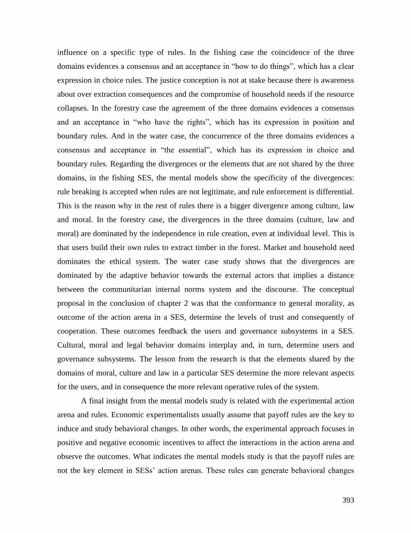
393
influence on a specific type of rules. In the fishing case the coincidence of the three
domains evidences a consensus and an acceptance in “how to do things”, which has a clear
expression in choice rules. The justice conception is not at stake because there is awareness
about over extraction consequences and the compromise of household needs if the resource
collapses. In the forestry case the agreement of the three domains evidences a consensus
and an acceptance in “who have the rights”, which has its expression in position and
boundary rules. And in the water case, the concurrence of the three domains evidences a
consensus and acceptance in “the essential”, which has its expression in choice and
boundary rules. Regarding the divergences or the elements that are not shared by the three
domains, in the fishing SES, the mental models show the specificity of the divergences:
rule breaking is accepted when rules are not legitimate, and rule enforcement is differential.
This is the reason why in the rest of rules there is a bigger divergence among culture, law
and moral. In the forestry case, the divergences in the three domains (culture, law and
moral) are dominated by the independence in rule creation, even at individual level. This is
that users build their own rules to extract timber in the forest. Market and household need
dominates the ethical system. The water case study shows that the divergences are
dominated by the adaptive behavior towards the external actors that implies a distance
between the communitarian internal norms system and the discourse. The conceptual
proposal in the conclusion of chapter 2 was that the conformance to general morality, as
outcome of the action arena in a SES, determine the levels of trust and consequently of
cooperation. These outcomes feedback the users and governance subsystems in a SES.
Cultural, moral and legal behavior domains interplay and, in turn, determine users and
governance subsystems. The lesson from the research is that the elements shared by the
domains of moral, culture and law in a particular SES determine the more relevant aspects
for the users, and in consequence the more relevant operative rules of the system.
A final insight from the mental models study is related with the experimental action
arena and rules. Economic experimentalists usually assume that payoff rules are the key to
induce and study behavioral changes. In other words, the experimental approach focuses in
positive and negative economic incentives to affect the interactions in the action arena and
observe the outcomes. What indicates the mental models study is that the payoff rules are
not the key element in SESs’ action arenas. These rules can generate behavioral changes

394
but in combination with other factors such as the legitimacy of rules in the fishing case, the
market, household needs and high levels of trust allowing the rule breaking in the forestry
case, and fairness in rule enforcement in the water case.
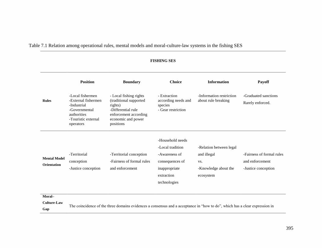
395
Table 7.1 Relation among operational rules, mental models and moral-culture-law systems in the fishing SES
FISHING SES
Rules
Position
Boundary
Choice
Information
Payoff
-Local fishermen
-External fishermen
-Industrial
-Governmental
authorities
-Touristic external
operators
- Local fishing rights
(traditional supported
rights)
-Differential rule
enforcement according
economic and power
positions
- Extraction
according needs and
species
- Gear restriction
-Information restriction
about rule breaking
-Graduated sanctions
Rarely enforced.
Mental Model
Orientation
-Territorial
conception
-Justice conception
-Territorial conception
-Fairness of formal rules
and enforcement
-Household needs
-Local tradition
-Awareness of
consequences of
inappropriate
extraction
technologies
-Relation between legal
and illegal
vs.
-Knowledge about the
ecosystem
-Fairness of formal rules
and enforcement
-Justice conception
Moral–
Culture-Law
Gap
The coincidence of the three domains evidences a consensus and a acceptance in “how to do”, which has a clear expression in
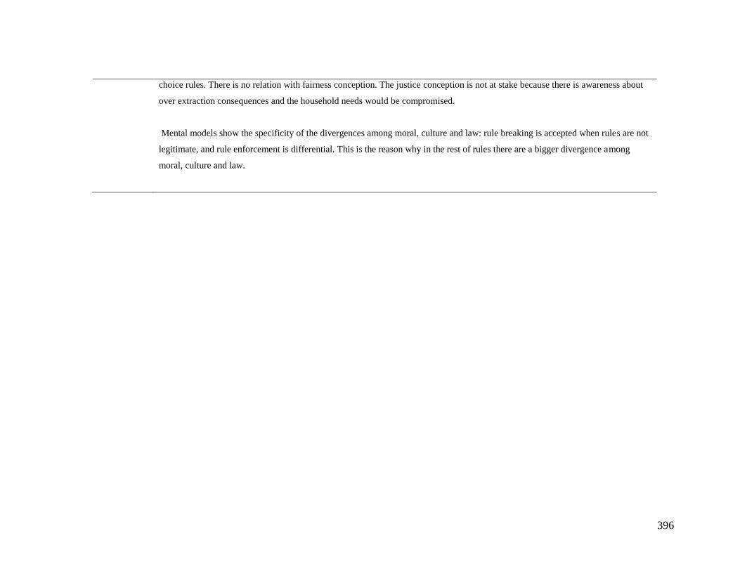
396
choice rules. There is no relation with fairness conception. The justice conception is not at stake because there is awareness about
over extraction consequences and the household needs would be compromised.
Mental models show the specificity of the divergences among moral, culture and law: rule breaking is accepted when rules are not
legitimate, and rule enforcement is differential. This is the reason why in the rest of rules there are a bigger divergence among
moral, culture and law.
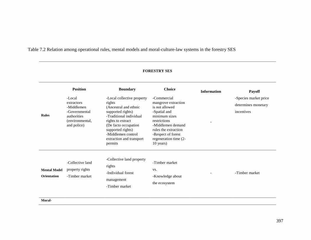
397
Table 7.2 Relation among operational rules, mental models and moral-culture-law systems in the forestry SES
FORESTRY SES
Rules
Position
Boundary
Choice
Information
Payoff
-Local
extractors
-Middlemen
-Governmental
authorities
(environmental,
and police)
-Local collective property
rights
(Ancestral and ethnic
supported rights)
-Traditional individual
rights to extract
(De facto occupation
supported rights)
-Middlemen control
extraction and transport
permits
-Commercial
mangrove extraction
is not allowed
-Spatial and
minimum sizes
restrictions
-Middlemen demand
rules the extraction
-Respect of forest
regeneration time (2-
10 years)
-
-Species market price
determines monetary
incentives
Mental Model
Orientation
-Collective land
property rights
-Timber market
-Collective land property
rights
-Individual forest
management
-Timber market
-Timber market
vs.
-Knowledge about
the ecosystem
- -Timber market
Moral-
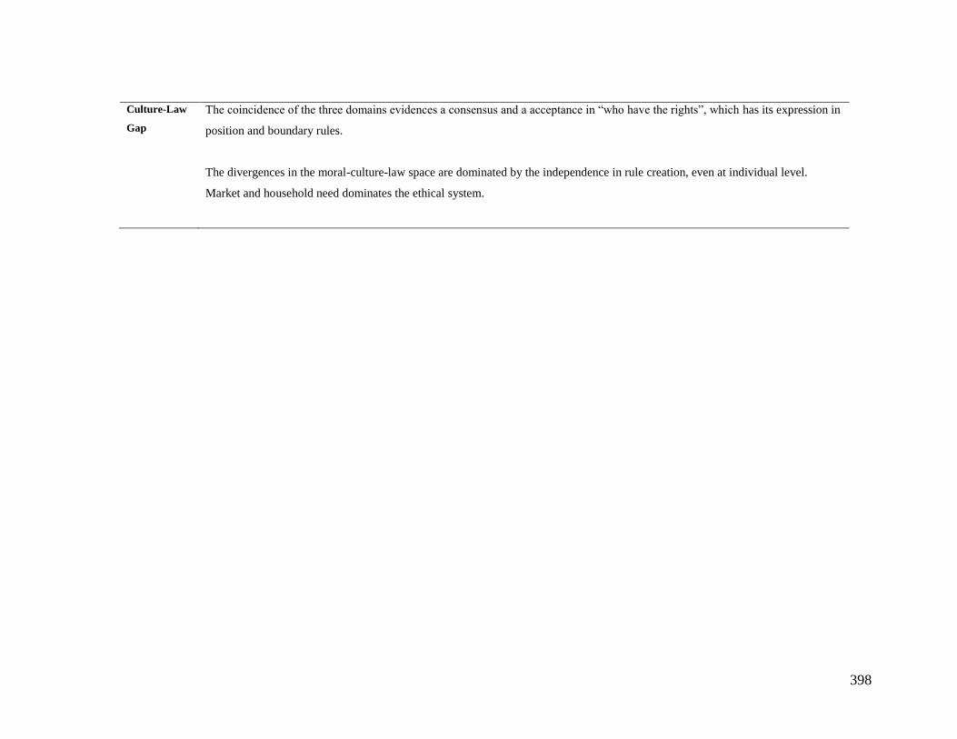
398
Culture-Law
Gap
The coincidence of the three domains evidences a consensus and a acceptance in “who have the rights”, which has its expression in
position and boundary rules.
The divergences in the moral-culture-law space are dominated by the independence in rule creation, even at individual level.
Market and household need dominates the ethical system.
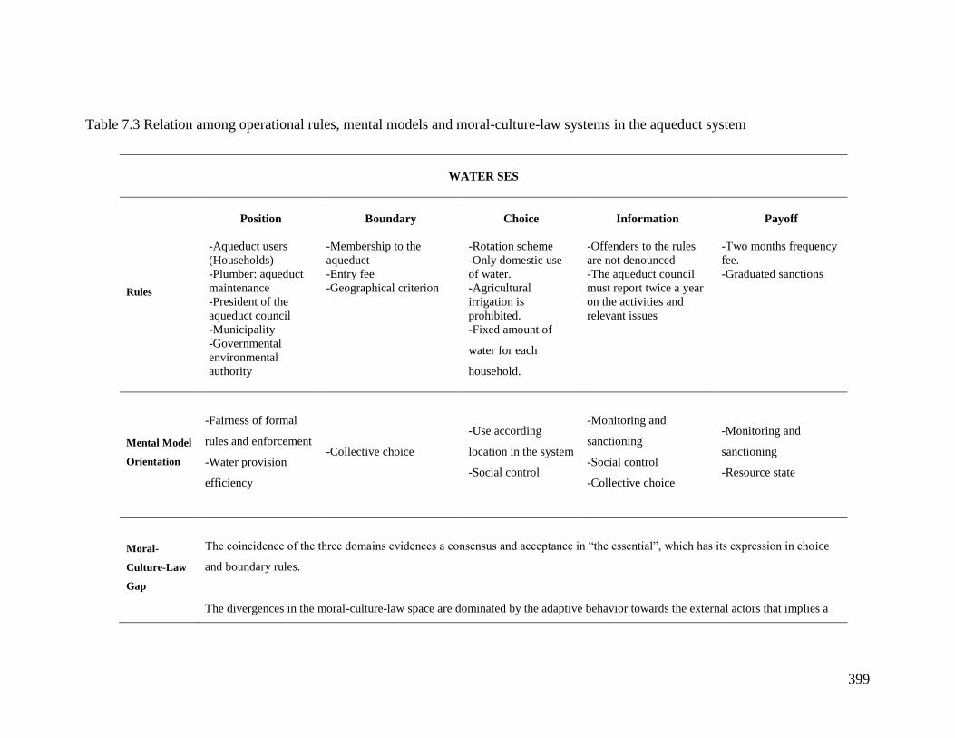
399
Table 7.3 Relation among operational rules, mental models and moral-culture-law systems in the aqueduct system
WATER SES
Rules
Position
Boundary
Choice
Information
Payoff
-Aqueduct users
(Households)
-Plumber: aqueduct
maintenance
-President of the
aqueduct council
-Municipality
-Governmental
environmental
authority
-Membership to the
aqueduct
-Entry fee
-Geographical criterion
-Rotation scheme
-Only domestic use
of water.
-Agricultural
irrigation is
prohibited.
-Fixed amount of
water for each
household.
-Offenders to the rules
are not denounced
-The aqueduct council
must report twice a year
on the activities and
relevant issues
-Two months frequency
fee.
-Graduated sanctions
Mental Model
Orientation
-Fairness of formal
rules and enforcement
-Water provision
efficiency
-Collective choice
-Use according
location in the system
-Social control
-Monitoring and
sanctioning
-Social control
-Collective choice
-Monitoring and
sanctioning
-Resource state
Moral-
Culture-Law
Gap
The coincidence of the three domains evidences a consensus and acceptance in “the essential”, which has its expression in choice
and boundary rules.
The divergences in the moral-culture-law space are dominated by the adaptive behavior towards the external actors that implies a
400
distance between the communitarian internal norms system and the discourse.
401
7.2 Methodological lessons
The methodological process of this research aimed to model a representation of the SESs in each
of the case studies and their explanations in cognitive terms. The starting point using a
researcher`s simple model of CPR dilemmas and SESs in the form of economic experiments
settings provided a useful initial reference point that allowed to acquire a particular perspective
of the problem studied. The collective construction of the RPG using such reference model was
effective not only to understand CPR users perspectives, but also to position researchers at the
same level of users and establish a productive dialogue. This dialogue produced different
versions of the action arena in which interactions occur. Though the RPG action arena
complemented by interviews and surveys provided a more complex model, they offer a sort of
static picture of the SES. The geographical and historical context research gave the essential
dimension to understand and unveil the roots of the so-called cognitive problem in CPR
management in the SESs studied. Experiments and RPG provide an action arena model but one
that resembles to be on the crest of the wave. The historical and geographic context provides the
richness of the longue durée in the sense of Fernand Braudel whose metaphor is quite
illustrative: the history is like the depth marine streams, but there are also, waves and storms in
the sea, they are the present events, the real change occurs when the marine streams change. I do
not claim that this study has documented as deep as the stream changes, but I believe that I have
studied at least the waves and their crests, and thanks to that I have discovered the importance of
moral systems in the dynamics of SESs.
The spirit of the methodological path followed in this research was inspired by the
ComMod perspective (Etienne, 2011), and a post-normal vision of science (Funtowitz and
Ravetz, 1994). From this perspective, SES management is a post-normal science issue because
there is a poor fit with conventional positivistic science that works better when systems are
bounded and easily controlled (Berkes and Berkes, 2009). The ultimate aim of this research was
to contribute to understand key elements for SES management, therefore the stance adopted was
the one mentioned above. The experiences carried out in each of the case studies did not close a
process like in a complete ComMod process due to logistics restrictions and contextual
conditions. It is fundamental for future research from the same perspective the involvement of a
formal process assessment tools in order to understand the effects of these kinds of interventions.
402
7.3 Commons, management and moral systems
Ostrom (1992) explains that there is no such thing like common pool resources, what happens is
that there are different management forms, one of these is their management as a common
property. The resource destruction depends on the way in which the property regime faces costs
and benefits distribution problems of the resource management. The first level of analysis to
address the cognitive problem in CPR management consists in the forms that governmental
authorities define the resource and the difference with the direct users understand and define the
problem. As a consequence, the situation in the practice is the existence of at least two
management styles superimposed. Management styles have assumptions about the right and
wrong practices, and about the type of desired SES, and the paths to achieve such system states.
The challenge is to understand the underlying logics of these styles, and this led to a deeper level
of analysis, which is the ethics, understood as the set of moral principles influencing and
governing behavior of human groups in charge of CPR management.
The main insight is that the issue cannot be treated as a simple divergence in
representations and variables taken into account by different actors; direct users and
governmental policy designers. The expectations at the beginning of this research consisted in
finding a sort of patterns of divergences in the understanding of the CPR dilemma across the
three case studies. But the research has shown that there are no patterns, at least at simple levels
such as more or less variables and relations defining used to define the problem. The problem is
more complex because it entails particular moral systems that are the product of particular
contexts and histories of the SESs. In terms of the conceptual framework used in this study, there
is a constant feedback from the action arena to the moral system as an outcome, but also this
moral system is shaping the action arena´s interactions, in order to produce trust and cooperation
levels and a behavioral spectrum. Therefore, in order to understand the behavioral outcomes in
CPR dilemmas, and designing policy interventions to improve CPR management, it is necessary
to understand the particular moral systems that are influencing also the contextual mental models
of SES’ actors.
403
8 CONCLUSIONS
In the introduction of this dissertation I proposed a research problem claiming that it was at the
core of the common pool resources management, and that was not enough investigated before.
The problem consists in the divergences between the CPR’ direct users, policy makers and
researchers on the nature of the CPR problems definition. This situation has been called a
cognitive conflict, because it implies different forms of understanding commons dilemmas,
which have consequences in the decisions, strategies and rules designed to overcome such
dilemmas. This problem led me to the central question of this research: What is the relation
between mental models and institutional arrangements in CPR management? In order to answer
this question I decided to examine three case studies in Colombia that could reflect the problem
in three classical CPR management: small scale fishing, water management and forestry. In the
process of disentangling the relation between these two (mental models and institutional
arrangements) variables I made a conceptual, methodological and empirical journey, which main
findings are synthetized in this chapter.
As a result of the revision of the conceptual state of the art regarding CPR dilemmas and
management, institutional analysis and Socio Ecological Systems (SESs), a conceptual
framework has proposed to guide the research. The SES approach has proved its usefulness to
frame and guide the study. Inside this framework the institutional analysis (IAD) has been used
to construct a unit of analysis (action arena) and propose a structure for the action arena`s
outcomes. This outcomes’ structure articulates mental models of resource users, moral systems,
institutional arrangements, and trust and cooperation levels that lead to behavioral types. The
conceptual revision allowed the definition of the elements that should be studied in each of the
relevant concepts mentioned above. For the mental models of the resource users, variables and
causal relations among them were the main variables to observe. For the institutional
arrangements, the IAD provides the concepts of action arena, interactions, outcomes rules in use
and typology of prescriptions (norms and rules). The IAD utilization also needed a decision
about the evaluative criteria to observe and discuss the outcomes. During the literature review
emerged the idea of the general morality conformance and trust and cooperation levels as
evaluative criteria. It was evident the gap in the commons research in examining the general
404
morality conformance. In short, the final analytical and conceptual tool is a proposal for the
outcomes structure briefly described above.
The SES approach works well to understand the role of the context in the action arena,
which is reflected in the outcomes. The geographic and historical context of the three case
studies has provided a clear perspective of the setting of each of the CPR case. The development
of this context was fundamental to understand the ecological and social dynamics of the cases as
well as the potential shocks that each SES could experience in the future. The use of the
diagnostic variables proposed by the SES framework allowed comparing the case studies in spite
of the different nature of the resource at stake. The comparison was carried out using the notion
of subsystems of a SES. They are resource system, resource units, governance system,
interactions, outcomes and potential shocks. Each of these subsystems has a set of second tier
variables that helps to compare the three case studies. The users and governance subsystems
guided the approach to the institutional analysis.
The institutional analysis showed that the most important outcome of the action situation
is the general level of morality conformance as a result of long-term institutional arrangements.
Individual and collective moralities are fundamental for reaching or not high levels of
cooperation and trust regarding common resources use and management. Cultural frameworks
include morality as one of their elements to select, interpret and present information. Morality
offers value judgments about what is morally acceptable or not about specific situations. In order
to relate morality with the institutional arrangements the different behavior al types of resource
users regarding rules and CPR management were interpreted as morally, culturally or legally
valid behavior. The development of the IAD showed that CPR users make daily compromises to
among the three types of valid behavior. As a reference point, and theoretically, when the
behavior of a group is at the same time morally, culturally and legally valid, the formal
institutions coincide with the rules in use, and the commons dilemma could be solved. The
central proposition is that a possible approach to the rule compliance solution is that cultural,
moral and legal behaviors coincide and the gap among the three sets is very small. A more
realistic vision is that each individual makes decisions as a result of a permanent tension among
the three domains. The process could be a conciliating process among the three domains giving
more weight to the options according to the particular action arena and interests at stake. In the
three SESs different types of gaps among morality, culture and law were found due to particular
405
historical and geographical contexts. In each of the case studies the findings could be synthetized
as follows.
The fisheries case shows the biggest gap among morality, culture and law, which reflects
a historic trend of formal illegality and lack of legitimacy of formal rules. This fact transforms
the action arena in to a game in which the moral and cultural behaviors are valid, but not the type
of behavior that follows the formal law. Therefore, rule enforcement and monitoring are only
rare and external events that fishermen must avoid.
In the forestry case the discourse of local activists does not coincide with the daily life
practices of the population, in terms of the pretended ancestral collective use of the land. This
fact makes difficult an effective process of institutional arrangements crafting that leads to
conflicts among leaders of ACAPA. This is the partial cause of the deviation of some elements
of the culture and moral domains from the legal valid behavior. This point constitutes an
important factor affecting the institutions in the utilization of the forest and could be an indicator
of the distance between mental models of inhabitants of ACAPA and the formal property regime
regarding the territory. This dynamics gives clues about the problem in this action situation:
weakly enforced rights, recent history of new property regimes and weak state institutions.
In the water case the there are few types of behavior that are shared by the three
behavioral domains; moral, cultural and legal. Here, again the historical trend of a colonial
relation that ruled the interactions since the Spaniards arrival originated a particular type of
interactions in the action arena that produced and continues generating a particular moral system
as one of the most important outcomes. Therefore, the aqueduct users are classified as rule
breakers by conviction.
The lesson is that the elements shared by the domains of moral, culture and law in a
particular SES determine the more relevant aspects for the users, and in consequence the more
relevant operative rules of the system.
The mental models study illustrated how the variables rule compliance; resource state and
extraction are fundamental for CPR users. As one of the results I proposed the notion of a
collective mental model, which consists in the aggregation of individual mental models of
resources users.
The importance of rule compliance for each case study could be explained as follows. Rule
compliance has a high value in the water case compared with the other two cases. This could be
linked to the successful management of the communitarian aqueduct. For the fishery case, rule
406
compliance has less importance reflecting that the central point is the inequality of rule
enforcement. The forestry case shows the lower importance for rule compliance. This is
according to the main characteristics of this system: forest use and management subordinated to
the market rules, high levels of corruption and unsatisfied basic needs (UBN). Regarding the
resource, in the fishery the variable is highly important reflecting the importance of the activity
and the awareness about it. In the forestry and water the resource variable is not as important as
in the fishery. The extraction variable is of high importance in the forestry case, users are
economically highly dependent on it and it is the driver of the timber market.
The convergence of mental models is one of the factors that affect the potential for self-
organization in CPR management. This is, the higher the level of homogeneity in the mental
models in a group of individuals in a CPR situation, the higher the possibilities that they could
develop institutional arrangements for a successful CPR management. A simple indicator of
homogeneity was developed for the three case studies. This calculation gives an indicator of
similarity, in number of variables, between the individual and the collective mental model.
Therefore, if the indicator has a value of 1, it means that the individual mental model has the
same number of variables that the collective one. On the contrary if the value is close to 0 the
individual mental model has very few variables. This indicator was calculated for each individual
mental model and then the average of this value for each case was calculated. The value for the
fishery case was 0,35; the forestry case gave a figure of 0,11 and the water case a score of 0,45.
The interpretation of this indicator is that the in the aqueduct system the level of homogeneity is
considerably higher than in the other cases. This could reflect the success of the self-organization
of the communitarian aqueduct (15 years), and also can be confirmed by the high importance of
the rule compliance variable in the collective mental model. The forestry case has a low
homogeneity score, which could be reflecting the complexity of the political and conflicting
context in which this SES has been developed. The high UBN (68%) could be related with the
high importance of the market in the use and management of the forest, even having an
autonomous governance system formally recognized by the Government. These conditions do
not facilitate the successful forest and territorial management. In the middle of the two cases is
the fishery case that has internal organizational and collective action difficulties.
The mental models study gives insight about the experimental action arena and rules.
Economic experimentalists usually assume that payoff rules are the key to induce and study
behavioral changes. In other words, the experimental approach focuses in positive and negative
407
economic incentives to affect the interactions in the action arena and observe the outcomes.
What indicates the mental models study is that the payoff rules are not the key element in SESs’
action arenas. These rules can generate behavioral changes but in combination with other factors
such as the legitimacy of rules in the fishing case, the market, household needs and high levels of
trust allowing the rule breaking in the forestry case, and fairness in rule enforcement in the water
case.
All the variables and relations present in a collective mental model do not work in every
situation in which agents make decisions. The specificity of the action arena activates and
neutralizes causal structures. A particular action arena provides the conditions for the strength or
weakness in terms of structural dominance of causal structures that govern the decision-making.
The hypothesis arising from this study is that the dominance of these causal structures is a
function of the action arena complexity. A collective mental model shows a wide spectrum of
variables and relations forming causal structures, but not the entire model is used in the actors’
decisions in a given action arena and in a specific realm, in this case common resources use and
management.
The mental models are highly contextual, and depend also on the moral system.
Cooperation and trust levels of commons users depend on these two systems. These levels
depend and also produce, in a feedback relation, different types of behavior called also
behavioral spectrum, when interactions are repetitive in time. The methodological framework
built for this research included, on one hand, economic experiments and individual surveys that
provided patterns of behavior of CPR users, and on the other collective construction of role
playing games as well as the role games implementation. These tools (role games) provided
contextual, rule crafting, and actor’s interactions information that was useful to understand the
behavioral patterns in the experimental action arena. In addition to that, in deep interviews were
carried out with key informants. The content analysis of the workshops and interviews allowed
carrying out the mental models study. The collective construction of the role games used as a
starting point the experimental settings, which were modified gradually and finally became a
more complex model of each SES. The methodology entailed a process of SES modeling,
starting from the experiments, which were designed by the researchers, and continued with a
more complex and shared (researchers and CPR users) representation of the SES. The use of
experiments and role games as intermediary objects allowed users to express through out these
objects instead of answer direct questions. This exercise produced relevant and complementary
408
information to conventional tools (surveys and interviews). But also the use of experiments and
role games construction and playing produced also reflection spaces to discuss among the CPR
users themselves. Finally, it is important to remark that though the analysis of the collected data
is difficult, the results proved to be useful to integrate the context to the micro variables of
behavior and mental models, as well as to explain behavioral patterns in experiments with
qualitative information.
409
REFERENCES
Abel, N., Ross, H., Herbert, A., Manning, M., Walker, P., & Wheeler, H. (1998). Mental Models
& Communication in Agriculture. Rural Industries Research and Development
Corporation (RIRDC.
Abella, F. (2001). Bases geohistóricas del Caribe Colombiano. En Respirando el Caribe.
Memorias de la Cátedra del Caribe colombiano. (A Castillo Mier.). Bogotá: Observatorio
del Caribe colombiano - Universidad del Atlantico - Ministerio de Cultura.
ACAPA. (2005). Gente de esteros, ríos y mar. Zonificación para la protección del territorio
colectivo de ACAPA. Bogotá: ASDI - Acción Social - Proyecto Protección de Tierras y
Patrimonio de la Población Desplazada.
Achard, F., Eva, H. D., Tibig, H.-J., Mayaux, P., Gallego, J., Richards, T., & otros, y. (2002).
Determination of Deforestation Rates of the World’s Humid Tropical Forests. Science,
297, 999-1002.
Acheson, J M. (2006). Institutional Failure in Resource Management. Annual Review of
Anthropology, 35, 117-134.
Acheson, James M. (2004). Capturing the Commons: Devising Institutions to Manage the Maine
Lobster Industry. UPNE.
Adams, W. M., Brockington, D., Dyson, J., & Vira, B. (2003). Managing Tragedies:
Understanding Conflict over Common Pool Resources. Science, 302.
Agrawal, A. (2001). Common property Institutions and Sustainable Governance of Resources.
World Development, 29, 1672.
Agrawal, A., Chhatre, A., & Hardin, R. (2008). Changing Governance of the World’s Forests.
Science, 320, 1462.
Almario, O. (2001). Tras las huellas de los renacientes. Por el laberinto de la etnicidad e
identidad de los grupos negros o «afrocolombianos» del pacifico sur. En Acción Colectiva,
estado y etnicidad en el Pacifico colombiano. Bogotá: Instituto Colombinao de
Antropología e Historia - Colciencias.
Anderies, J. M., Janssen, M. A., & Ostrom, E. (2004). A framework to analize the robustness of
social-ecological systems from an institutional perspective. Ecology and Society, 9.
410
Argyris, C., & Schon, D. A. (1974). Theory in Practice: Increasing Professional Effectiveness
(1.a ed.). Jossey-Bass.
Argyris, C., & Schon, D. A. (1995). Organizational Learning II: Theory, Method, and Practice.
FT Press.
Aristotle. (1977). Politics. (H. Rackham, trad.). Cambridge, Massachusetts: Harvard University
Press.
Arnold, C. A. (2001). Rethinking Moral Economy. American political Science Review, 95(1),
85-95.
Arnold, J. E., & Campbell, G. (1986). Collective Management of Hill Forests in Nepal: The
Community Forestry Development Project. En Proceedings of the Conference on Common
Property Resource Management, National Research Council (pp. 425-54). Washington,
DC: National Academy Press.
Axelrod, R. M. (1976). Structure of Decision: The Cognitive Maps of Political Elites. Princeton
Univ Pr.
Baland, J.-M., Bardhan, P., & Bowles, S. (2006). Inequality, Cooperation, and Environmental
Sustainability. Princeton University Press.
Baland, J.-M., & Platteau, J.-P. (2000). Halting Degradation of Natural Resources: Is there a
Role for Rural Communities? Oxford University Press, USA.
Barnaud, C. (2008). Équité, jeux de pouvoir et légitimité : les dilemmes d’une gestion concertée
des ressources renouvelables. Mise à l’épreuve d’une posture d’accompagnement critique
dans deux systèmes agraires des hautes terres du Nord de la Thaïlande (PhD dissertation
in Géographie humaine, èconomique et régionale). Université Paris X Nanterre.
Barreteau, O., & And others. (2003). Our Companion Modelling Approach. Recuperado marzo
3, 2012, a partir de http://jasss.soc.surrey.ac.uk/6/2/1.html
Barreteau, O., Bousquet F, Étienne M, Souchère V, & D’ Aquino P. (2011). Companion
modelling: a method of adaptive and participatory research. En Companion modelling: A
participatory Approach Supporting Sustainable Development (Étienne M (Ed).). Versailles
Cedex: Éditions Quae.
Barrows, R., & Roth, M. (1990). Land Tenure and Investment in African Agriculture: Theory
and Evidence. Journal of ModernAfrican Studies, 28(2), 265-297.
Becu, N. (2006). Identification et modélisation des représentations des acteurs locaux pour la
gestion des bassins versants. (PhD). University of Montpellier 2, Montpellier.
411
Beratan, K. K. (2007). A Cognitiona-based View of Decision Processes in Complex Social-
Ecological Systems. Ecology and Society, 12.
Berkes, F. (2007). Community-based conservation in a globalized world. Proceedings of the
National Academy of Sciences, 104(39), 15188 -15193. doi:10.1073/pnas.0702098104
Berkes, F., Colding, J., & Folke, C. (Eds.). (2003). Navigating Social-Ecological Systems:
Building Resilience for Complexity and Change (1st ed.). Cambridge University Press.
Berkes, F., Feeny, D., McCay, B. J., & Acheson, J. M. (1989). The benefits of the commons.
Nature, 340(6229), 91-93. doi:10.1038/340091a0
Berkes, F., Hughes, T. P., Steneck, R. S., Wilson, J. A., Bellwood, D. R., Crona, B., … Worm,
B. (2006). Globalization, Roving Bandits, and Marine Resources. Science, 311(5767),
1557-1558. doi:10.1126/science.1122804
Berkes, F., Mahon, R., McConney, P., Pollnac, R., & Pomeroy, R. (Eds.). (2001). Managing
Small-Scale Fisheries: Alternative Directions and Methods (1.a ed.). IDRC Books.
Berkes, Fikret. (1999). Sacred Ecology: Traditional Ecological Knowledge and Resource
Management. Taylor & Francis Group.
Berkes, Fikret, & Berkes, M. K. (2009). Ecological complexity, fuzzy logic, and holism in
indigenous knowledge. Futures, 41(1), 6-12. doi:10.1016/j.futures.2008.07.003
Berkes, Fikret, & Folke, C. (Eds.). (1998). Linking Social and Ecological Systems: Management
Practices and Social Mechanisms for Building Resilience (First Edition.). Cambridge
University Press.
Berry, S. (1992). Hegemony on a Shoestring: Indirect Rule and Acces to Agricultural Land.
Africa, 62(3), 327-355.
Biggs, H., Toit, du, Etienne, D., Jones, M., Leitch, N., Lynam, A., & T. (2008). A preliminary
exploration of two approaches for documenting «mental models» held by stakeholders in
the Crocodile Catchment. South Africa. CSIRO - INRA - Resilience Allience-South Adrican
National Parks-Water Research Commission. Water Rsearch Commission.
Borgatti, S., Everett, M., & Freeman, L. (2002). UCINET 6 For Windows: Software for Social
Network Analysis. Harvard, MA: Analytic Technologies.
Botsford, L. W., Castilla, J. C., & Peterson, C. H. (1997). The Management of Fisheries and
Marine Ecosystems. Science, 277(5325), 509-515. doi:10.1126/science.277.5325.509
Bousquet, F., Barreteau O, D’ Aquino P, Etienne M, Boissau E, Aubert, … Castella J-C. (2003).
Multi-agent systems and role games: collective learning processes for ecosystem
412
management. En Complexity and ecosystem management: the theory and practice of multi-
agent systems (Janssen M.). Northhampton: Edward Elgar Publishing. Cheltenham.
Bousquet, F., & Barreteau, O. (1999). An environmental modelling approach. The use of multi-
agents simulations. En Advances in Environmental and Ecological Modelling (F. Blasco
and A. Weill., pp. 113-122). Paris: Elsevier.
Bousquet, F., & Trebuil, G. (2005). Introduction to companion modeling and multi-agent
systems for integrated natural resource management in Asia. En Companion modeling and
multi agent systems for integrated natural resource management in Asia (Bousquet,
François and Trebuil, Guy.). Manila: International Rice Research Institute.
Bowles, S. (2006). Microeconomics: Behavior, Institutions, and Evolution. Princeton University
Press.
Bowles, S., & Gintis, H. (2004). The evolution of strong reciprocity: cooperation in
heterogeneous populations. Theoretical Population Biology, 65(1), 17-28.
doi:10.1016/j.tpb.2003.07.001
Brunet, R. (1990). Le déchiffrement du monde. En Géographie Universelle Tome 1. Paris:
Hachette/Reclus.
Brunet, R., Ferras, R., & Théry, H. (1993). Les mots de la géographie, dictionnaire critique.
Montpellier-Paris: RECLUS - La Documentation Française.
Cahuc, P. (1993). La nouvelle microéconomie. La Découverte.
Camerer, C. (2003). Behavioural studies of strategic thinking in games. Trends in Cognitive
Sciences, 7, 225-231.
CAR, C. A. R. de C. (2006). Plan de Ordenación de la Cuenca de los Ríos Ubaté y Suarez.
Diagnostico, Prospectiva y formulación de la cuenca hidrográfica de los Ríos Ubaté y
Suarez.
Cardenas, J C. (2001). How Do Groups Solve Local Commons Dilemmas? Lessons from
Experimental Economics in the Field. Environmental, Development and Sustainability, 2,
3-4.
Cardenas, J C. (2009). Experiments in Environment and Development. Annual Review of
Resource. Economics, 1, 157-182.
Cardenas, J. C. (2009). Dilemas de lo colectivo. Instituciones, pobreza y cooperación en el
manejo local de los recursos de uso común. Bogotá: Ediciones Uniandes. Recuperado a
partir de http://www.lalibreriadelau.com/a-p20485
413
Cardenas, Juan Camilo, Janssen, M. A., & Bousquet, F. (in press). Dynamics of Rules and
Resources: Three New Field Experiments on Water, Forests and Fisheries. En Handbook
on Experimental Economics and the Environment (John List and Michael Price.). Edward
Elgar Publisher.
Cardenas, Juan Camilo, & Ostrom, E. (2004). What do people bring into the game? Experiments
in the field about cooperation in the commons. Agricultural Systems, 82(3), 307-326.
doi:10.1016/j.agsy.2004.07.008
Castillo, D., & Saysel, A. K. (2005). Simulation of common pool resources field experiments: a
behavioral model of collective action. Ecological Economics, 55, 420-436.
Castillo, Daniel, Bousquet, F., Janssen, M. A., Worrapimphong, K., & Cardenas, J. C. (2011).
Context matters to explain field experiments: Results from Colombian and Thai fishing
villages. Ecological Economics, 70(9), 1609-1620. doi:10.1016/j.ecolecon.2011.05.011
Cendales, M., Zea, S., & Díaz, J. M. (2002). Geomorfología y Unidades ecológicas del complejo
de arrecifes de las Islas del rosario e Isla Barú (Mar Caribe, Colombia). . Revista de la
Academia Colombiana Ciencias Exactas, Físicas y Naturales. XXVI, 101, 497-510.
Chaiken, S., & Trope, Y. (Eds.). (1999). Dualprocess theories in social psychology. New York,
USA: Guilford Press.
Charnley, S., & Poe, M. R. (2007). Community Forestry in Theory and Practice: Where Are We
Now? *. Annual Review of Anthropology, 36, 301-336.
doi:10.1146/annurev.anthro.35.081705.123143
CINEP. (1998). Colombia País de Regiones (Vol. II). Bogotá: CINEP, Colciencias.
CIOH-CARDIQUE. (1998). Caracterización y Diagnóstico Integral de la Zona Costera
Comprendida desde Galerazamba y Bahía Barbacoas. Cartagena, Colombia.
CIP, & Consorcio para el Desarrollo Sostenible de la EcoregiónAndina. (n.d). Proyecto Cuencas
Andinas. Centro Internacional de la Papa. Recuperado a partir de
http://www.condesan.org/cuencasandinas/fuquene.htm
Coase, R. (1937). The Nature of the Firm. Economica, 4, 386-405.
Coffey, A. J., & Atkinson, P. A. (1996). Making Sense of Qualitative Data: Complementary
Research Strategies (1.a ed.). Sage Publications, Inc.
Colmenares, G. (1976). Historia económica y social de Colombia: 1537-1719. TM.
Cominelli, E., Galbiati, M., Tonelli, C., & Bowler, C. (2009). Water: the invisible problem.
EMBO reports, 10, 671-676.
414
Corbin, J., & Strauss, A. (2007). Basics of Qualitative Research: Techniques and Procedures for
Developing Grounded Theory (3rd ed.). Sage Publications, Inc.
Costanza, R., & Ruth, M. (1998). Using dynamic modeling to scope environmental problems and
build consensus. Environmental management, 22, 183-195.
Costanza, Robert, Cumberland, J. H., Daly, H., Goodland, R., & Norgaard, R. B. (1997). An
Introduction to Ecological Economics (1.a ed.). CRC Press.
Craik, K. J. W. (1943). The Nature of Explanation. CUP Archive.
Crawford, S., & Ostrom, E. (1995). A Grammar of Institutions. American political Review, 89,
582-600.
Daly, H. E., & Cobb, J. B. (1994). For The Common Good: Redirecting the Economy toward
Community, the Environment, and a Sustainable Future (2nd,Updated ed.). Beacon Press.
Daly, H. E., & Farley, J. (2010). Ecological Economics, Second Edition: Principles and
Applications (2.a ed.). Island Press.
DANE. (1993). Censo Nacional de Población y Vivienda. Depertamento Administrativo
Nacional de Estadística.
DANE. (2005). Censo Nacional de Población y Vivienda. Depertamento Administrativo
Nacional de Estadística.
Davidson, H., & Berkes, F. (2003). Navigating social-ecological systems: building resilience for
complexity and change. En Nature and society through the lens of resilience. Cambridge,
UK; New York: Cambridge University Press.
Deadman P. (1999). Modelling individual behaviour and group performance in an intelligent
agent-based simulation of the tragedy of the commons. Journal of Environmental
Management, 56, 159-172.
Debarbieux, B. (1995). Le lieu, le territoire et trois figures de rhétorique. L’Espace
géographique, (2), 97 -112.
Del Castillo, N. (1982). Esclavos negros en Cartagena y sus aportes léxicos. Bogotá: Instituto
Caro y Cuervo.
Del Valle, J. (1996). El medio biofísico de los bosques de guandal. En J. Del Valle & E.
Restrepo (eds.), Renacientes del guandal. «Grupos negros» de los ríos Satinga y
Sanquianga. Bogotá: UN-PBP.
Deneux, J.-F. (2006). Histoire de la pensée géographique. Paris: Belin.
Denzau, A., & North, D. (1994). Shared Mental Models: Ideologies and Institutions. Kyklos, 47,
415
3-31.
Di Meo, G. (2001). Géographie sociale et territoires. Paris: Nathan.
Dietz, T., Ostrom, E., & Stern, P. C. (2003). The Struggle to Govern the Commons. Science,
302.
DNP. (1996). Política de bosques (Documento COMPES No. 2834). Bogotá: Minambiente-
DNP-UPA.
Doyle, J. K., & Ford, D. N. (1999). Mental models concepts for system dynamics research.
System Dynamics Review, 15, 411-415.
Dray, A., Perez, P., Jones, N., Le_Page, C., D’Aquino, P., White, I., & T Auatabu. (2006). The
AtollGame experience: from knowledge engineering to a computer-assisted role playing
game. Journal of Artificial Societies and Social Simulations 9(1):6.
Du Toit, D. R., Biggs, H., & Pollard, S. (2011). The Potential Role of Mental Model
Methodologies in Multistakeholder Negotiations: Integrated Water Resources Management
in South Africa. Ecology and Society, 16(3). doi:10.5751/ES-04237-160321
Durán, C. . (2007). ¿Es nuestra isla para dos? Conflicto por el desarrollo y la conservación en
Islas del Rosario, Cartagena. Bogotá: Ediciones Uniandes.
Escobar, A. (1997). Politica Cultural y Biodiversidad: Estado, capital y Movimientos Sociales en
el Pacífico Colombiano. En Antropología en la Modernidad: Identidades, etnicidades y
movimientos sociales en Colombia. Bogotá: Instituto Colombiano de Antropología e
Historia.
Escobar, A. (2000). El lugar de la naturaleza y la naturaleza del lugar ¿globalización o
postdesarrollo? Colonialidad del Saber.
Etayo, F. (1968). Sinopsis estratigráfica de la región de Villa de Leiva y zonas próximas. U. I.
Santander, Ed.) Boletín de Geología, 21, 19-32.
Etienne, M., Du Toit, D. R., & Pollard, S. (2011). ARDI: A Co-construction Method for
Participatory Modeling in Natural Resources Management. Ecology and Society, 16(1).
Recuperado a partir de http://www.ecologyandsociety.org/vol16/iss1/art44/
Evans, J., Over, D. E., & Handley, S. J. (2003). A theory of hypothetical thinking. En D.
Hardman & Macchi (eds.), Thinking: psychological perspectives on reasoning, judgment
and decision making. Chichester, UK.: John Wiley.
FAO (Ed.). (1987). FAO Essays in memory of Jean Carroz. The Law and the Sea. Mélanges à la
mémoire de Jean Carroz. Le Droit et la Mer. Ensayos en memoria de Jean Carroz. El
416
Derecho y el Mar. Recuperado a partir de
http://www.fao.org/docrep/s5280T/s5280T00.htm
Feeny, D., Richards, J. F., & Tucker, R. P. (1988). Agricultural Expansion and Forest Depletion
in Thailand, 1900–1975. En World Deforestation in the Twentieth Century (pp. 425-54).
Durham, NC: Duke University Press.
Ferber, J. (1999). Multi-agent systems: An introduction to distributed artificial intelligence.
Addison-Wesley Professional.
Flórez, A. (2005). Una isla en un mar de sangre. El Valle de Ubaté dutante la violencia (And
Island in a sea of blood. The Ubaté Valley during La Violencia) (Centro Editorial
Javeriano CEJA - La Carreta Editores.). Bogotá.
Flórez, A., & Millán, C. (2007). Derecho a la Alimentación y al Territorio en el Pacífico
Colombiano. Diócesis de: Tumaco, Quibdo, Buenaventura y de Istmina. Vicariato
Apostolado de Guapi.
Floréz, J. (1991). La Escuela dela Economía Moral. Algunas de sus Limitaciones para el Analisis
de lo Político en lo Cmapesino. Cuadernos de Agroindustria y Enomía Rural, 26, 133-50.
Forrester, J. (1971). Counterintuitive behavior behavior of social systems. Technology Review,
73(3), 52-68.
Freeman, L. (1979). Centrality in social networks: Conceptual clarification. Social Networks,
1(3), 215-239.
Frey, B., Benz, M., & Stutzer, A. (2004). Introducing Procedural Utility: Not Only What, but
Also How Matters. Journal of Institutional and Theoretical Economics (JITE), 160(3).
Recuperado a partir de http://ideas.repec.org/a/mhr/jinste/urnsici0932-
4569(200409)1603_377ipunow_2.0.tx_2-x.html
Funtowicz, S., & Ravetz, J. (1994). The worth of a songbird: ecological economics as a post-
normal science. Ecological Economics, 10, 197-207.
Gadgil, M., & Berkes, F. (1991). Traditional resource management systems. Resource
Management and Organization, 8, 127-41.
Gentner, D., & Stevens, A. (1983). Mental Models. Lawrence Erlbaum Associates.
Giddens, A. (1987). Social theory and modern sociology. Stanford University Press.
Gintis, H. (2000). Beyond Homo economicus: evidence from experimental. Ecological
Economics, 35, 322.
Gintis, H., Bowles, S., Boyd, R., & Fehr, E. (2003). Explaining altruistic behavior in humans.
417
Evolution and Human Behavior, 24, 153-172.
Gleick, P. H. (2003). Water Use. Annual Review of Environment and Resources, 28, 275-314.
Guhl, E. (1982). Los páramos circundantes de la Sabana de Bogotá. Jardín Botánico «José
Celestino Mutis».
Gurung, T., Bousquet F, & Trebuil G. (2006). Companion modeling, Conflict resolution and
Institution Building: Sharing Irrigation Water in the Lingmuteychu. Ecology and Society,
11, 36.
Haidt, J. (2007). The New Synthesis in Moral Psychology. Science, 316(5827), 998-1002.
doi:10.1126/science.1137651
Haidt, J., & Kesebir, S. (2010). Morality. En Handbook of Social Psychology (5th Edition., pp.
797 - 832). Hobeken, NJ: Wiley.
Hardin, G. (1968). The Tragedy of the Commons. Science, 162, 1243-48.
Harris, S. G. (1994). Organizational Culture and Individual Sensemaking: A Schema-Based
Perspective. Organization Science, 5, 309-321.
Hauser, M. (2007). Moral Minds: The Nature of Right and Wrong. Harper Perennial.
Hautdidier, B. (2007). Bûcherons et dynamiques institutionnelles locales au Mali. Agro Paris
Tech.
Hayek, F. (1952). The Sensory Order: An Inquiry into the Foundations of Theoretical
Psychology. Chicago: University of Chicago Press.
Herrera, M. (2002). Ordenar para controlar. Ordenamiento espacial y control político en las
llanuras del Caribe y en los Andes centrales negroandinos. Siglo XVIII. Bogotá: Academia
Colombiana de Historia - Instituto Colombiano de Antropología e Historia.
Herrera, M. (2005). Muiscas y Cristianos: del biohote a la misa y el tránsito hacia una sociedad
individualista. En Muiscas, Representaciones Cartografías y Etnopoliticas de la memoria
(p. 380). Bogotá: Pontificia Universidad Javeriana.
Hilborn, R., Branch, T. A., Ernst, B., Magnusson, A., Minte-Vera, C. V., Scheuerell, M. D., &
Valero, J. L. (2003). State of the World’s Fisheries. Annual Review of Environment and
Resources, 28(1), 359-399. doi:10.1146/annurev.energy.28.050302.105509
Hilton, R. M. (2002). Institutional incentives for resource mobilization in farmaer-managed and
agency-managed irrigation systems. En Improving Irrigation Governance and
Management in Nepal (Shivakoti, G. and Ostrom E. (Eds)., p. 282). Oakland, California:
Institute of Contemporary Studies Press.
418
Hodgson, M. A. (1994). Hexagons for systems thinking. En J. D. W. Morecroft & J. D. Sterman
(eds.), Modeling for Learning Organisations (pp. 359-374). Portland, OR: Productivity
Press.
Hofstede, R. (2002). Los Páramos andinos; su diversidad, sus habitantes, sus problemas y sus
perspectivas. Un breve diagnóstico regional del estado de conservación de los páramos.
(Vol. II).
Holland, J. H., Holyoak, K. J., Nisbett, R. E., & Thagard, P. (1986). Induction: Processes of
Inference, Learning, and Discovery (Reprint.). A Bradford Book.
Holling, C., Gunderson, L., Gunderson, L. L., & Holling, C. S. (2002). In Quest of a Theory of
Adaptive Change. En Panarchy : understanding transformations in human and natural
systems. Washington, D.C: Island Press.
Holling, C. S., & Gunderson, L. H. (2002). Resilience and adaptive Cycles. En Panarchy.
Understanding Transformations in human and natural systems (p. 507. Washington: Island
Press.
Hubach, E. (1953). Geología de la Isla del Santuario. Isla de Fuquene. Santa Fé de Bogotá:
Servicio Geológico Nacional.
IDEAM. (1996). Unidades Geomorfològicas del Territorio Colombiano. Recuperado diciembre
3, 2007, a partir de http://www.ideam.gov.vo/publica/index4.htm
IGAC. (2002). Atlas de Colombia (5.a ed.). Bogotá: Instituto Geográfico Agustin Codazzi -
Imprenta _Nacional de Colombia.
Jackson, J. B. C., Kirby, M. X., Berger, W. H., Bjorndal, K. A., Botsford, L. W., Bourque, B. J.,
… Warner, R. R. (2001). Historical Overfishing and the Recent Collapse of Coastal
Ecosystems. Science, 293(5530), 629-637. doi:10.1126/science.1059199
Jager, W. (2000). Modelling Consumer Behavior.
Janssen, M. (2002). A Future of Surprises. En L. Gunderson & C. S. Holling (eds.), Panarchy :
understanding transformations in human and natural systems. Washington, D.C: Island
Press.
Janssen, M. A. (2003). Complexity and Ecosystem Management: The Theory and Practice of
Multi-Agent Systems (illustrated edition.). Edward Elgar Pub.
Janssen, M. A., Bousquet, F., Cardenas, J.-C., Castillo, D., & Worrapimphong, K. (2012). Field
experiments on irrigation dilemmas. Agricultural Systems, 109(0), 65-75.
doi:10.1016/j.agsy.2012.03.004
419
Janssen, M., Bousquet François, Cardenas Juan Camilo, Castillo Daniel, & Worrapimphong
Kobchai. (submitted). Breaking the Elected Rules in a Field Experiment on Forestry
Resources.
Janssen, M., Bousuquet, F., & Ostrom, E. (2011). A multimethod approach to study the
governance of social-ecological systems. Natures Sciences Sociétés.
doi:10.1051/nss/2011135
JICA. (2000). estudio sobre plan de mejoramiento ambiental regional para la cuenca de la laguna
Fúquene. . JICA. Agencia de cooperación internacional del Japón. CAR Corporación
Autónoma regional de Cundinamarca Colombia. CTI Engineering interantional co., Ltda.
Johnson-Laird, P. N. (Philip N. (1983). Mental Models: Towards a Cognitive Science of
Language, Inference, and Consciousness. Harvard University Press.
Jones, N. A., Ross, H., Lynam, T., Perez, P., & Leitch, A. (2011). Mental models: an
interdisciplinary synthesis of theory and methods. Ecology and Society, 16, 46.
Kim, H. (2009). In search of a mental model-like concept for group-level modeling. System
Dynamics Review, 25(3), 207-223.
Knight, F. (1921). Risk, Uncertainty, and Profit. New York: Houghton Mifflin and Co.
Langebaek, C. . (1995). Arqueología regional en el territorio Muisca: estudio de los Valles de
Fúquene y Susa. Regional Archeology in the Muisca Territory; a study of the Fúquene and
Susa Valleys. Pittsburgh; Santa Fé de Bogotá: University of Pittsburgh; Universidad de los
Anedes, Departamento de Antropología.
Laurin, S., Klein, J.-L., & Tardiff, C. (2001). Géographie et société, vers une géographie
citoyenne. En Géographie et société. Montréal: Presses de l’Université du Québec.
Le Page, C., Abrami G, Barreteau O, Becu N, Bommel P, Botta A, … Souchère V. (2011).
Models for sharing representations. En Companion modelling: A participatory Approach
Supporting Sustainable Development (Étienne M (Ed).). Versailles Cedex: Éditions Quae.
Leal, C., & Restrepo, E. (2003). Unos bosques sembrados de aserríos. Historia de la extracción
maderera en el Pacífico colombiano. Medellín: Editorial Universidad de Antioquia.
Leopold, A. (1949). A Sand County Almanac. Oxford University Press.
Levi, M. (2003). The transformation of a Skeptic: What Nonexperimentalists Can Learn from
Experimentalists. En Trust & Reciprocity. Interdisciplinary Lessons from Experimental
Research. New York: Russell Sage Foundation.
Levin, S. (2000). Fragile Dominion: Complexity and the Commons. Basic Books.
420
Liverman, D. M., & Vials, S. (2006). Neoliberalism and the Environment in Latin America.
Annual Review of Environment and Resources, 31, 327-363.
Lloyd, W. F. (1833). Two lectures on the Checks to Population. En Population, Evolution and
Birth Control. A College of Controversial readings. San Francisco.
Luce, R., & Raiffa, H. (1957). Games and Decisions. New York: John Wiley.
Luhmann, N. (1982). Trust and Power. John Wiley & Sons Inc.
Luteyn, J. (1999). Paramos: a checklist of plant diversity, geographical distribution, and
botanical literature (Vol. 84). USA: The New York Botanical Garden.
Martínez, J. (2006). Pacífico en llamas. Realidad socioeconómica de la costa nariñense. San
Juan de PAsto: Editorial Universitaria - Universidad de Nariño.
Mathevet, R., Etienne, M., Lynam, T., & Calvet, C. (2011). Water Management in the Camargue
Biosphere Reserve: Insights from Comparative Mental Models Analysis. Ecology and
Society, 16(1). Recuperado a partir de http://www.ecologyandsociety.org/vol16/iss1/art43/
Maya, D., Castillo, D., Ramos, P., & Roldan, A. M. (2004). Análisis de la Acción Colectiva para
el Manejo de Cuencas. Estudio Piloto: Cuenca de la Laguna de Fúquene. Informe final de
Investigación. Pontificia Universidad Javeriana; Proyecto Regional "Cuencas Andinas.
CONDESAN-REDCAPA-GTZ); Corporación Autónoma Regional.
Maya, L. (2004). Demografía historica de la trata por Cartagena 1533-1810. En Geografía
Humana de Collombia (Vol. VI Los Afrocolombianos). Instituto Colombiano de
Antropología e Historia ICANH.
McCay, B. J., & Acheson, J. M. (Eds.). (1990). The Question of the Commons: The Culture and
Ecology of Communal Resources. University of Arizona Press.
McLaughlin, D., & Arce, M. (1975). Mapa Geológico del Cuadrángulo K-11. Zipaquira:
Ingeominas.
McNeely, J. A. (1993). Economic incentives for conserving biodiversity: lessons for Africa.
AMBIO, XXII(2-3).
Meadows, D., Fiddaman, T., & Shannon, D. (1989). Fish Banks, Ltd. Hood House,University of
New Hampshire, Durham, NH 03824: Institute for Policy and Social Science Research.
Miles, M., & Huberman, M. (1994). Qualitative Data Analysis: An Expanded Sourcebook (2.a
ed.). Sage Publications, Inc.
Millennium Ecosystem Assessment. (2005). Ecosystems and Human Well-being: Biodiversity
Synthesis. Washington, DC.: World Resources Institute.
421
Mockus, A. (1994). Anfibios culturales y divorcio entre ley, moral y cultura. Análisis Político,
21.
Mockus, A. (2002). Co-existence as harmonization of law, morality and culture. Prospects,
32(1), 19-37.
Morecroft, John D. W., & Sterman, J. D. (2000). Modeling for Learning Organizations (1.a ed.).
Productivity Press.
Moxnes, E. (1998a). Not only the tragedy of the commons, misperceptions of bioeconomics.
Management Science, 44, 1234-1248.
Moxnes, E. (1998b). Overexploitation of renewable resources: The role of misperceptions.
Journal of Economic Behavior & Organization, 37, 107-127.
Moxnes, E. (2004). Misperceptions of basic dynamics: the case of renewable resource
management. System Dynamics Review, 20, 162.
Muhr, T. (2010). ATLAS.ti. Berlin: Scientific Software Development. Recuperado a partir de
http://www.atlasti.com/
Myers, R. A., & Worm, B. (2003). Rapid worldwide depletion of predatory fish communities.
Nature, 423(6937), 280-283. doi:10.1038/nature01610
Nash, J. F. (1950). Equilibrium points in n-person games. Proceedings of the National Academy
of Sciences, 36(1), 48-49. doi:10.1073/pnas.36.1.48
Norberg, J., Wilson, J., Walker, B., & Ostrom, E. (2008). Diversity an Resilience of Social-
Ecological Systems. En Complexity Theory for a Sustainable Future. New York: Columbia
University Press.
Norman, D. (1983). Some observations on Mental Models. En Mental Models (pp. 7-14).
Hillsdale: Hillsdale: Lawrence Erbaum Associates, Publishers.
North, D. (1994). Economic performance trhough time. American Economic Review, 84, 359-
368.
North, Douglas C. (2007). Para Entender el Proceso de Cambio Economico (unknown.).
NORMA.
North, Douglass C. (1990). Institutions, Institutional Change and Economic Performance.
Cambridge University Press.
Nowak, M. A. (2006). Five Rules for the Evolution of Cooperation. Science, 314(5805), 1560 -
1563. doi:10.1126/science.1133755
Nowak, M. A., & Sigmund, K. (1998). The dynamics of indirect reciprocity. Journal of
422
Theoretical Biology, 194, 561 - 574.
Olson, M. (1965). The Logic of Collective Action: Public Goods and the Theory of Groups
(Revised.). Harvard University Press.
Oslender, U. (1999). Espacio e identidad en el Pacífico colombiano. En De montes, ríos y
ciudades. Territorios e identidades de la gentenegra en Colombia. Santa Fé de Bogotá:
Fundación Natura - Ecofondo - Instituto Colombiano de Antropología.
Oslender, U. (2002). The Logic of the River: A Spatial Approach to Ethnic-Territorial
Mobilization in the Colombian Pacific Region. The Journal of Latin American
Anthropology, 2, 86-117.
Ospina, D. (2008). Reconstrucción histórica del sistema de extracción forestal en el Territorio
Colectivo del Consejo Comunitario ACAPA: los últimos 60 años (1950- presente).
Pontificia Universidad Javeriana, Facultad de Estudios Ambientales y Rurales, Carrera de
Ecología, Bogotá.
Ostrom, E. (1992). The Rudiments of a Theory of the Origins, Survival, and Performance of
Common-Property Institutions. En D. Bromley (ed.), Making the Commons Work. Theory,
Practice, and Policy (p. 339). Institute of Contemporary Studies Press.
Ostrom, Elinor. (1990). Governing the Commons: The Evolution of Institutions for Collective
Action. Cambridge University Press.
Ostrom, Elinor. (1998). A behavioral approach to the rational choice theory of collective action.
American Political Science Review, 92, 1-22.
Ostrom, Elinor. (2005). Understanding Institutional Diversity. Princeton University Press.
Ostrom, Elinor. (2006). The Institutional Analysis and Development Framework in Historical
Perspective. Retrieved 03 26, 2009, from Paper presented at the annual meeting of the.
American Political Science Association, Marriott, Loews Philadelphia, and the
Pennsylvania Convention Center, Philadelphia, PA Online <APPLICATION/PDF>.:
http://www.allacademic.com/meta/p152652_index.html.
Ostrom, Elinor. (2007). A diagnostic approach for going beyond panaceas. Proceedings of the
National Academy of Sciences, 104(39), 15181 -15187. doi:10.1073/pnas.0702288104
Ostrom, Elinor. (2009). A General Framework for Analyzing Sustainability of Social-Ecological
Systems. Science, 325, 419-422.
Ostrom, Elinor, Gardner, R., & Walker, J. (1994). Rules, Games, and Common-Pool Resources.
University of Michigan Press.
423
Ostrom, Elinor, & Walker, J. (2003). Trust And Reciprocity: Interdisciplinary Lessons For
Experimental Research (Russell Sage Foundation Series on Trust. Russell Sage
Foundation.
Ostrom, V., & Ostrom, E. (1977). Public Goods and Public Choices. En Alternatives for
Delivering Public Services: Toward Improved Performance (E. S. Savas., pp. 7-49).
Boulder, CO: Westview Press.
Oviedo, R. (1996). Historias de Gente Entintada. Bogotá: ICANH - PNR.
Ozesmi, U., & Ozesmi, S. (2004). Ecological models based on people’s knowledge: a multi-step
fuzzy cognitive mapping approach. Ecological Modelling, 176, 43-64.
Pahl-Wostl, C., Tàbara, D., Bouwen, R., Craps, M., Dewulf, A., Mostert, E., … Taillieu, T.
(2008). The importance of social learning and culture for sustainable water management.
Ecological Economics, 64(3), 484-495.
Parra, L. N., & Jaramillo, A. (2006). Geomorfología de la región del Patia. Revista Ambiental.
Agua, Aire y Suelo, 1, 14.
Pauly, D., Christensen, V., Dalsgaard, J., Froese, R., Jr, T., & F. (1998). Fishing Down Marine
Food Webs. Science, 279, 860.
PNNC. (2006). Plan de Manejo del Parque Nacional Natural Corales del Rosario y San bernardo
2005-2009. Parques Nacionales Naturales de Colombia. Territorial Caribe. Cartagena.
Poteete, A. R., Janssen, M. A., & Ostrom, E. (2010). Working Together: Collective Action, the
Commons, and Multiple Methods in Practice. Princeton University Press.
Prahl, H. ., & Erhardt, H. (1985). Colombia: corales y arrecifes coralinos. Bogotá: FEN.
Proyecto Páramo Andino. (2008). Diagnostico Sociocultural del Páramo de Rabanal. Instituto de
Instituto de Investigación de Recursos Biológicos Alexander Von Humboldt. Recuperado a
partir de http://www.humboldt.org.co/chmcolombia/servicios/jsp/paramos/
Raffestin, C. (1980). Pour une géographie du pouvoir. Paris: Litec.
Ramsay, M. (1996). Community, Culture, and Economic Development: The Social Roots of
Local Action. Albany: State University of New York Press.
Rapoport, A., & Chammah, A. M. (1965). Prisioner’s Dilema: A Study in Conflict and
Cooperation. University of Michigan Press.
Resilience Alliance. (n.d). Resilience Alliance. Recuperado mayo 13, 2008, a partir de
http://www.resalliance.org/
Restrepo, E. (1997). Unos bosques sembrados de aserríos: la industria maderera en el Pacífico
424
colombiano. Bogotá: Proyecto Biopacífico.
Restrepo, E. (2005). De paraíso de paz al infierno de guerra: Implicaciones del conflicto
armado en el proceso organizativo de «comunidades negras» del Pacífico nariñense.
ICANH.
Restrepo, E. (2010). Conflicto armado y proceso organizativo en el Pacífico sur colombiano.
Working paper.
Retaillé, D. (1997). Le monde du géographe. Paris: Editions des Pesses de sciences politiques.
Reyes, G., Guzman, G., Barbosa, G., & Zapata, G. (2001). Geología de las planchas 23
Cartagena y 29-30 Arjona. Escala 1 : 100.000. Memoria explicaticativa. Instituto de
Investigación e Información Geocientifica, Minero-ambiental y Nuclear.
Rivas, N. . (2001). Ley 70 y medio ambiente: El Caso del consejo comunitario ACAPA, Pacífico
Nariñense. En Acción Colectiva, Estado y Etnicidad en el Pacífico Colombiano (p. 310).
Bogotá: Instituto Colombinao de Antropología e Historia - Colciencias.
Romney, A. K., Weller, S. C., & Batchelder, W. H. (1986). Culture as consensus: a theory of
culture and informant accuracy. American Anthropologists, 88(2), 313-338.
Rosegrant, M. W., Ringler, C., & Zhu, T. (2009). Water for Agriculture: Maintaining Food
Security under Growing Scarcity. Annual Review of Environment and Resources, 34(1),
205-222. doi:10.1146/annurev.environ.030308.090351
Rubio, F. (2001). Plan de manejo y uso sostenible del páramo de Rabanal.
Rudd, M. A. (2004). An institutional framework for designing and monitoring ecosystem-based
fisheries management policy experiments. Ecological Economics, 48, 124.
Sarmiento, G., Gaviria, S., Hooghiemstra, H., Berrio, J. C., & Van_der_Hammen, T. (2008).
Landscape evolution and origin of Lake Fuquene (Colombia): Tectonics, erosion and
sedimentation processes during the Pleistocene. Geomorphology, 100, 563-575.
Schelling, T. (1960). The Strategy of Conflict. Cambrdige: Harvard University. Harvard
University Press.
Scott, P. J. C. (1977). The Moral Economy of the Peasant: Rebellion and Subsistence in
Southeast Asia. Yale University Press.
Scott, P. J. C. (1987). Weapons of the Weak: Everyday Forms of Peasant Resistance. Yale
University Press.
Scott, P. J. C. (1992). Domination and the Arts of Resistance: Hidden Transcripts (1st
Edition(PB).). Yale University Press.
425
Seidel, J., & Kelle, U. (1995). Different functions of coding in the analysis of textual data. En U.
Kelle (ed.), Computer-aided qualitative data analysis: theory, methods and practice (pp.
52-61). London: Sage.
Senge, P. M. (1990). The Fifth Discipline: The Art and Practice of the Learning Organization.
Random House.
Shepherd, G. (1992). Managing Africa’s Tropical Dry Forests: A Review of Indigenous Methods.
London: Overseas Development Institute.
Shipton, P. (1988). The Kenyan Land Tenure Reform: Misunderstandings in the Public Creation
of Private Property. En R. E. Downs & Reyna (eds.), Land and Society in Contemporary
Africa (pp. 91-135). Hanover, NH: University Press of New England.
Siegel, D. J. (2001). Towarsd an interpersonal neurobiology of the developing mind:attachement
relationships, «mindsight», and neural integration. Infant Mental Health Journal, 22, 67-
94.
Siegert, L. M. (2006). Análisis antropológico del impacto del turismo en las poblaciones raizales
en Santa Ana, isla de Barú (Tesis de pregrado). Universidad de los Andes, Bogotá.
Smith, E. R., & DeCoster, J. (2000). Dual process models in social and cognitive psychology:
conceptual integration and links to underlying memory systems. Personality and Social
Psychology Review, 4, 108-131.
Smith, V. (2008). Theory and Experiment: What are the questions? Journal of Economic
Behavior & Organization, doi:, 10-1016.
Steer Ruiz, R., & Et al. (1997). Documento base para la elaboracion de la «Politica nacional de
ordenamiento integrado de las zonas costeras colombianas» (Documento de consultoría
para el Miniterio del Medio Ambiente) (p. 390). Bogotá: Ministerio del Medio Ambiente.
Sterman, J. D. (2000). Business Dynamics: Systems Thinking and Modeling for a Complex World
with CD-ROM. McGraw-Hill/Irwin.
Sterman, J. D. (2008). Risk Communication on Climate:Mental Models and Mass Balance.
Science, 322, 532-533.
Sterman, J. D., & Sweeney, L. B. (2002). Cloudy skies: assessing public understanding of global
warming. System Dynamics Review, 18, 207-240.
Sterman, J. D., & Sweeney, L. B. (2007). Understanding public complacency about climate
change: adults’ mental models of climate change violate conservation of matter. Climatic
Change, 80, 213-238.
426
Stockholm Resilience Center. (nd). Recuperado octubre 29, 2009, a partir de
http://www.stockholmresilience.org/research/whatisresilience/resiliencedictionary.4.aeea4
6911a3127427980004355.html
Stokstad, E. (2008). A Second Chance for Rainforest Biodiversity. Science, 320, 1438.
Stokstad, E. (2009). Détente in the Fisheries War. Science, 324, 171.
Stone-Jovicich, S. S., Lynam, T., Leitch, A., & Jones, N. A. (2011). Using Consensus Analysis
to Assess Mental Models about Water Use and Management in the Crocodile River
Catchment, South Africa. Ecology and Society, 16(1). Recuperado a partir de
http://www.ecologyandsociety.org/vol16/iss1/art45/
Suchman, L., Trigg, R., & Blomberg, J. (2002). Working artefacts: ethnomethods of the
prototype. British Journal of Sociology, 53(2), 163-179.
Sukumar, R. (2008). Forest Research for the 21st Century. Science, 320, 1395.
Tesch, R. (1990). Qualitative Research: Analysis Types and Software Tools (1.a ed.). Routledge.
Thompson, E. P. (1971). The Moral Economy of the English Crowd in the 18th Century. Past &
Present, 50, 76-136.
Thomson, J., Feeny, D., & Oakerson, R. (1992). Common-Property Resource Management. En
D. Bromley (ed.), Making the Commons Work. Theory, Practice, and Policy (p. 339). San
Francisco: ICS Press.
Toro-Ramirez, A. . (2005). Esquema de Subducción del Pacífico Colombiano. Ingeominas.
Tucker Wrightson, M. (1976). The Documentary Coding Method. En Structure of Decision. The
Cognitive Maps of Political Elites (Robert Axelrod., p. 404). Princeton, New Jersey:
Princeton University Press.
Ulloa, C., & Rodriguez, E. (1991). Plancha 190-Chiquinquirá (Departamento de Boyacá).
memoria Explicativa. Ingeominas, Santa Fé de Bogot.
Van den Belt M. (2004). Mediated Modeling: A System Dynamics Approach To Environmental
Consensus Building (1.a ed.). Island Press.
Van Der Hammen, T. (1968). Climatic and vegetational succession in the Equatorial Andes of
Colombia. Colloquium Geographicum, 1, 187-194.
Van Lange, P. A. M., Liebran, W. B. G., Messick, D. M., & Wilke, H. A. M. (1992). Social
dilemmas: The state of the art. Introduction and literature review. En W. Liebrand, D.
Messick, & H. Wilke (eds.), Social Dilemmas. Theoretical issues and research findings.
Oxford/New York: Pergamon Press.
427
Velasco-Graciet, H. (2006). Territoires, mobilités et sociétés. Contradictions et enjeux
géographiques. Dossier d’habilitation à diriger des recherches ; Pessac : Université
Michel de Montaigne Bordeaux 3.
Vennix, J. (1996). Group Model Building: Facilitating Team Learning Using System Dynamics
(1.a ed.). Wiley.
Ventana Systems, Inc. (2010). VENSIM. Ventana Systems, Inc. Recuperado a partir de
http://www.vensim.com/index.html
Vieira Pak, M., & Castillo Brieva, D. (2010). Designing and implementing a Role-Playing
Game: A tool to explain factors, decision making and landscape transformation.
Environmental Modelling & Software, 25(11), 1322-1333.
doi:10.1016/j.envsoft.2010.03.015
Villa, W. (2004). El territorio de comunidades negras, la guerra en el Pacífico y los problemas de
desarrollo. En M. Pardo, C. Mosquera, & M. C. Ramírez (eds.), . Bogotá: ICANH - UN.
Von Neuman, J., & Morgenstern, O. (1994). Theory of Games and Economic Behavior.
Princeton NJ: Princeton University Press.
Wade, R. (2007). Village Republics: Economic Conditions for Collective Action in South India
(1.a ed.). Cambridge University Press.
Walker, B., Gunderson, L., Kinzig, A., Folke, C., Carpenter, S., & Schultz, L. (2006). A Handful
of Heuristics and Some Propositions for Understanding Resilience in Social-Ecological
Systems. Ecology and Society, 11 (1).
Walsh, J., Henderson, D., & Deighton, J. (1988). Negotiated belief structures and decision
performance: an empirical investigation. Organizational Behavior and Human Decision
Processes, 42, 194-216.
Webb, C., & Bodin, O. (2008). A network perspective on modularity and control of flow in
robust systems. En Complexity theory for a sustainable future (Jon Norberg and Graeme S.
Cumming., p. 315). New York: Columbia University Press.
Weber, J. (1995). gestion des resources reouvelables: fondements théoriques d’un programme de
reccherche (p. 21). CIRAD.
Weber, J., & Bailly, D. (1993). Prévoir, c’est gouverner. Natures-Sciences-Sociétés, 1(1), 59-64.
Weber, J., & Reveret, J.-P. (1993, octubre). Biens communs: les leurres de la privatisation. Une
Terre en Renaissance. Orstom et Le Monde Diplomatique, coll. Savoirs(No. 2).
West, R. (1957). The Pacific lowlands of Colombia: A Negroid Area of the American Tropics.

428
Baton Rouge: Louisiana State.
Westley, F., Carpenter, S. R., Brock, W. A., Holling, C. S., & Gunderson, L. H. (2002). Why
Systems of People and Nature Are Not Just Social and Ecological Systems. En Panarchy.
Understanding transformations in human and natural systems (p. 507. Washington: Island
Press.
White, A., & Martin, A. (2005). Who Owns the Word’s Forests? Forest Tenure and Public
Forests in Transition. En The Earthscan Reader in Forestry and Development. Routledge.
Worm, B., Hilborn, R., Baum, J. K., Branch, T. A., Collie, J. S., Costello, C., & otros, y. (2009).
Rebuilding Global Fisheries. Science, 325, 578.
Worm, Boris, Barbier, E. B., Beaumont, N., Duffy, J. E., Folke, C., Halpern, B. S., … Watson,
R. (2006). Impacts of Biodiversity Loss on Ocean Ecosystem Services. Science,
314(5800), 787-790. doi:10.1126/science.1132294
Zambrano, F. (2000). Historia del poblamiento del territorio de la región Caribe de Colombia. En
Poblamiento y ciudades del Caribe Colombiano.
429
APPENDIX I
Experimental Action Arenas
A simplified model of the fishery action arena: the fishery experiment
The fishery economic experiment described in chapter 3 (Methodological framework) constitutes
an action arena, which represents a basic CPR problem. The experimental setting is described in
detail in (Cardenas et al. in press). The following paragraphs give a description of such action
arena. In the experiment there is only one position, players that could be filled by five
participants, which are fishermen. Actions assigned to positions include fishing effort allocation
and deciding where to go fishing. The effort decision could be 0, 1 or 2, and the fishery spots are
A and B, where participants can make their spatial choice. Information available to positions is
the total effort put on each fishery place, as well as the payoffs according to the condition of each
fishery place. Communication among participants is not allowed and individual actions and
payoffs are not public. Information available to players is complete regarding the state of the
resource, but there is a considerable level of uncertainty on outcomes predictions in each round
of the game due mainly to the private character of the individual decisions.
Relevant variables in this game are state of fishing places A and B; high and low stock,
and individual earnings. Therefore the participants have a partial control over the outcomes
because the state of variables depends, not only on individual actions, but on the other four
participants. The external rewards or payoffs of the experiment (Table 3.3, payoff table on
methodological chapter) are a function of fishery spot’s condition. In the first stage of the
experiment there are no costs associated with the possible actions that produce benefits. But in
the second stage there are costs in the form of sanctions for breaking a given rule if a participant
is inspected at the end of a round.
As already explained in chapter 3, the second stage of the experiment introduces three
different rules that are chosen through voting by players before starting the round eleven. These
three rules are aimed to solve the commons problem and improve outcomes of the action arena.
430
The rules (lottery, rotation and quota) are choice and payoff rules affecting two structural
elements of the action arena: actions, and net costs and benefits. With any of the rules each
player has a probability of 1/6 of being inspected and if the player is not following the rule he
has to return his harvest. In this way the action has a cost caused by the sanction, and the payoffs
are affected.
A simplified model of the forestry action arena: the forestry experiment
The forestry experiment constitutes an action situation in which there is only one position:
logger, which is filled by five participants. These participants face a repeated game during
twenty rounds divided in two stages. Two actions are assigned to positions. In the first stage each
participant choose how many trees to harvest from the forest, with a maximum of five trees in
each round. At the beginning of the second stage they have to vote for a rule to play 10 more
rounds. The resource is constituted by 100 trees of the same species that has a 10% growth rate.
The information provided to players includes: the total number of trees harvested by the group in
each round, the forest growth rate, tokens earned by each tree harvested and a spatially explicit
representation of the forest, in which, each tree is represented by a magnetic token that is
removed or added according of the dynamics of the game in each round. In this way players
actually see the size of the common resource and its dynamics through the rounds. The number
of trees remaining in the forest, besides the graphical information, is announced at the end of
each round. Communication among players is not allowed.
The important variables in this game are the state of the resource (number of trees in the
forest), and individual earnings. The payoffs or benefits of the experiment are proportional to the
tokens earned by harvesting trees; each tree harvested is equivalent to one token, which has a
monetary value. In terms of costs, in the first part there are no costs for harvesting decisions. In
the second phase, the costs are present in the form of a probable fine (1/6 probability of
inspection) if a player is caught breaking a rule at the end of each round. As in the other two
experiments, in the second phase players have to choose among three rules: lottery, rotation and
property rights, aimed to maximize collective benefits and producing resource sustainability.
These are choice and payoff rules affecting actions and costs and benefits of the action situation.
This experiment is described in detail in chapter 3 and in Cardenas et al. (2008).
431
A stylized model of the water action arena: the water experiment
This action situation was conceptualized according to the essence of the dilemma in a typical
irrigation system. In this case the dilemma has a particular characteristic that consists in the
asymmetric character of the access to the resource. Users in the upper part of the basin have
access to the resource first, but also they access a resource in better conditions in terms of
quantity and quality. While the access possibilities of downstream users decrease in quantity and
potentially in quality when negative externalities such as pollution are produced by upstream
users. An experimental action situation was designed for five players (Juan Camilo Cardenas
et al., in press), and the interaction was repeated during 20 rounds, divided in two parts of 10
rounds each one. The resource (water) is provided according to the private investments of each
participant, once the players have contributed, an amount of water is produced that is available
for each player´s plot.
In this experiment there is only one position that is the player that could be filled by five
participants. Each participant has a plot and the plots are distributed along a channel that has
upper and lower ends, and are named with the letters A, B, C, D and E. The plots receive water
in order being first A and the last E. Once the total water produced according the collective
contributions, player situated in plot A decides privately the amount of water he wants to take.
From the remaining volume of water, the player situated in the plot B decides the volume of
water he wants to take, and so on, until the turn of the last player, who is located in the plot E.
The actions assigned to positions are two: how much tokens (between 0 and 10) to contribute to
the provision of water, and after all the participants have made their contribution, the next
decision is what volume of water to take from the available resource.
Public information available to the positions is the total water produced. Each participant,
according to his position on the channel, knows privately how much water is available for him.
Communication is no allowed among participants and individual decisions and payoffs are
private. There is a big uncertainty when trying to predict outcomes, first the quantity of water
produced, and the water available to extract. The level of uncertainty increases from upper part
of the channel to the lower part, this is the player in the position A has less uncertainty than the
rest of the players, until position E whose available water depends on the decisions of the
precedent participants. The individual benefits are produced by the addition of the tokens that
each participant keep and does not put in the public fund for generation of water, and the units of
water each one take, in his turn, from the available water.
432
The experiment is run during 20 rounds. During the first 10 rounds participants are not
allowed to communicate among themselves. This is the base line (first part or first stage). Before
starting the round 11 players are asked to vote anonymously for three proposed rules, and the
elected rule is implemented in rounds 11 to 20 (second part or stage). The rules are:
“Rule 1 (Lottery). Each round the order in which participants can collect from the
common resource is randomly drawn after everybody has made their decision how much
to invest in the water provision. Rule 2 (Rotation). There is a fixed rotation system of the
order in which people can collect from the common resource, starting with ABCDE in
round 1, then BCDEA, etc. Rule 3 (Property rights): Each participant receives the right
to use 20 percent of the common resource. The order to extract water remains the same
for all the rounds: ABCDE. A dice is thrown in each round. When 6 is thrown,
participants who collect a higher amount than the share of 20 percent have to pay back
the excess water harvested, and also pay a penalty of 6 additional tokens.” (Juan Camilo
Cardenas et al., in press).
The important variables in the experimental action situation are the contributions to the
public good that is transformed in units of water available for the group, the level of extraction
and payoffs. The control each participant has over the outcomes is low because the state of the
main variables depends not only of two kinds of decisions of other participants, but also of the
position in the channel that generates interdependency among participants. There are no costs
such as sanctions for certain type of decision in the first part of the experiment, but in the second
stage, one rule, out of three is voted to play another ten rounds. The rules affect actions and net
costs and benefits and are aimed to solve the commons dilemma in its provision and
appropriation dimensions.
433
APPENDIX II
Experimental Protocols
Recruitment letter
I am a professor/researcher of Andes University/ French Agricultural Research Centre for
International Development. I am conducting a research study to how people govern natural
resources collectively. Due to your experience with managing natural resources, your
participation is very important for this research. The exercise and the following workshop will
give important information for all of us including your community. The funding for this project
came from International Organizations and the Andes University/CIRAD.
Your participation in this study is voluntary. You earn 5 dollars by showing up at the exercises,
and can earn up to 40 dollars extra in the exercise depending on your decisions and those of the
other participants. You may leave the exercise at any time. However, if you decide to leave
before the exercise is over you will not receive what you earned. If you have any questions
concerning the research study, please contact me at ( ) ___- ____.

434
Forest game
We would like to thank you for accepting this invitation. We will spend about three hours
explaining the activity, playing and answering a short survey at the end. Let’s start.
The following exercise is a different and entertaining way to actively participate in a project
about individual decisions and natural resources. Besides participating in this exercise and
earning money, you will participate in a workshop in the coming days in order to jointly discuss
the exercise as well other topics about natural resources. The funds to cover these expenses have
been donated by a scientific body.
In this exercise it is intended to recreate a situation in which a group or family must make
decisions about the use of a forest. You have been selected to participate in a five person group
recruited from a group of people who have been subscribed to be willing to participate.
This exercise is different than exercies in which other persons in this community have played
already. Therefore, comments you have heard from other persons do not apply necessarily to this
exercise.
You will play several rounds equivalent, for example, to years or wood harvest seasons.
Let’s pretend this group has an area of forest with 100 initial resource units. Each round you
have to make a decision about how many resource units you want to harvest. You can harvest a
maximum of 5 units and minimum of 0 units of the resource.
[Visual explanation; we have a number of magnets on the board which represent the forest units.
The instructor shows what happens if a number of units are harvested]
Between the rounds the resource is regrowing. For each ten units of the existing resource, one
new unit is added for the next round.
435
[visual explanation; the monitor shows with the magnets that for each row of 10 magnets one
new magnet is added to the forest, use rows of 10 magnets on the board]. The forest cannot grow
to more than 100 units.
Each participant makes a harvest decision. Each harvest unit is equivalent to $0.50. For example,
if you harvest 50 units during 20 rounds you will receive $25.
When the size of the resource is less than 25 units, the maximum harvest is less than 5 units.
In the MAXIMUM HARVEST LEVEL TABLE, that is green, which will be distributed now
[MONITOR distributes the MAXIMUM HARVEST LEVEL TABLE at the same time he shows
a poster on the wall of the same table]. I will announce the maximum quantity of units you can
harvest according to the size of the resource at the beginning of the round and post it on the wall.
In order to make decisions in each round you must write down your decision on your YELLOW
DECISION SHEET, a number between 0 and the MAXIMUM HARVEST LEVEL depending
on the current resource level. [MONITOR shows the yellow decision sheet at the same time that
shows a poster on the wall with the same card]. Please check your player number on the yellow
decision sheet. This will be your player number from now on.
Observe that the sheet has a row with the round number. Next there is a row marked with “my
harvest decision”, in this space you will write down the harvest level you decided in this round.
It is very important to know that you must make your decisions privately. Therefore, you need to
write down the numbers on the decision sheet in private and you can not show them to the rest of
the group members. The MONITOR will collect the YELLOW DECISION SHEETS from all of
you and she or he will sum the total of units the group decided to harvest. When the monitor
announces the group harvest total I will write on the board the new resource level. You will then
get the decision sheets back for the next round.
Let us explain this with an example (Use visual explanation).

436
Suppose the current size of the resource is 68. Each of you decided to harvest 3 units, and thus a
total of 15 units. The resource size reduces to 53 (68-15) and then 10% of 53, which is 5 units, is
added, which leads to 58 units. Thus 15 units are harvested, and the size of the resource, after
regrowth, is reduced with 10 units. And each participant earned 3 points during this round.
For each 10 units of resource 1 unit is added. If there are no 10 units of resource we do not
increase the resource, it means if there are less than 10 units we do not add 1 unit more. If the
resource is less than 5 units, no units can be harvested any more. Now let’s continue with the
next round. Now the current size of the resource is 58 units. It means that the maximum harvest
allowed remains 10 units according to the MAXIMUM HARVEST LEVEL TABLE.
Again, each player decides how many units to harvest and again we calculate the resource
decreasing and its increase in a 10% for new level of the resource.
Now we are going to explain the YELLOW DECISION SHEET, the sheet the
MONITOR has handed in to you.
[Before we start the monitor will announce one additional rule for this group.]
To start the first round of the game we will organize the seats and desks in a circle where each of
you face outwards. The monitor will collect in each round your YELLOW DECISION SHEET.
Finally, to get ready to play the game, please let us know if you have difficulties reading or
writing numbers and one of the monitors will seat next to you to assist you with these. Also keep
in mind that from now on no conversation or statements should be made by you during the game
unless you are allowed to.
We will have first a few rounds of practice that will NOT count for the real earnings, just for
practicing of the game.
[up to three practice rounds are performed and questions are addressed during the practice]
The initial size of the resource is 100 units

437
[After the practice rounds announce that the initial size of the resource is again 100 units and that
the decisions are now real and affect the earnings]
438
INSTRUCTIONS FOR THE FOREST GAME
SECOND STAGE
[After 10 real rounds we let the participants vote for one of three rules.]
We give you the opportunity to start over the game with a different rule. I will describe three
rules and you write down on your VOTING CARD your favorite rule. The monitor will collect
the votes and count them. [If two rules get 2 votes, we do a new voting round with only these to
rules]
The rule which derives the most votes will be implemented.
Rule 1. With this rule only two participants can harvest each round. Who is allowed to harvest is
determined by drawing two cards with players numbers. The instructor writes down the player
numbers who are allowed on the board.
When someone harvest, but is not allowed to, this participant may get a penalty. Every round we
throw a dice after the decisions are made and the yellow sheets are turned in. If we throw a six an
inspector is in the forest and will catch the rule breakers, the participants who harvested in a turn
it was not allowed to. In that case the participant has to payback the harvest plus an extra 3 units.
If the dice shows any other number everybody keeps its earnings and we pass to the next round.
Rule 2. With this rule each participant will have its turn to extract forest unit. Only two
participants can harvest each round. In this way it will be a rotation scheme to extract forest
units. Each participant will be assigned randomly a turn card to extract forest units: The
extraction order is:
Round 1: extracts wood the players A, B
Round 2 extracts wood the players C, D
Round 3: extracts wood the players E, A
Round 4: extracts wood the players B, C
Round 5: extracts wood the players D, E
Round 6: extracts wood the players A, B
Round 7: extracts wood the players C, D
Round 8 extracts wood the players E, A
Round 9: extracts wood the players B, C
439
Round 10: extracts wood the players D, E
(explain explicitly that after this rule is chosen, players get randomly a character A, B, C, D or E.
player 1 may for example get turn D)
When someone harvest, but is not allowed to, this participant may get a penalty. Every round we
throw a dice after the decisions are made and the yellow sheets are turned in. If we throw a six an
inspector is in the forest and will catch the rule breakers, the participants who harvested in a turn
it was not allowed to. In that case the participant has to payback the harvest plus an extra 3 units.
So, if participant whose turn is A is writing down on the decision sheet to harvest 3 units when
only the player with turn C is allowed to harvest, we throw a dice, and when we throw a six,
participant with turn A do not get the units on its decision sheet, and we subtract an extra 3 from
the total collected units of player with turn A. If the dice shows any other number everybody
keeps its earnings and we pass to the next round.
Rule 3. Each of you can harvest legally 0, 1 or 2 units per round. If a participant writes a higher
amount than 2 on its YELLOW DECISION SHEET, he or she can be caught by the inspector
and has to pay a penalty. In every round we throw a dice. And when we throw a six, and the
participants who harvest more than 2 units in that round, do not get the units it wrote down on its
YELLOW DECISION SHEET, and we subtract an extra 3 units from it’s total so far.
Summary:
Rule 1: only 2 persons, randomly determined, allowed to harvest in each round.
Rule 2: only 2 persons, predetermined sequence, allowed to harvest in each round
Rule 3; a maximum of 2 units can be harvested in each round by any person
Do you have any questions about the rules?
Write down your favorite rule on the VOTING CARD, by writing a 1, a 2 or a 3. And turn it in
to the monitor
[When we determine the results of the voting the participants fill in the survey on the rules;

440
When we are determining the voting results, we ask you to fill in this survey about the rules we
just described].
441
INSTRUCTIONS FOR THE IRRIGATION GAME
FIRST STAGE
We would like to thank you for accept this invitation. We will spend about three hours
explaining the activity, playing and answering a short survey at the end. Let’s start.
The following exercise is a different and entertaining way to actively participate in a project
about individual decisions and natural resources. Besides participating in this exercise and
having the chance of earn money, you will participate in a workshop in the coming days in order
to jointly discuss the exercise as well other topics about natural resources. The funds to cover
these expenses have been donated by a scientific body.
In this exercise it is intended to recreate a situation in which a group or family must make
decisions about the use of water to irrigate its plots. You have been selected to participate in five
persons group among persons who have been subscribed to participate. This exercise is different
to others in which others persons have played already in this community. Therefore, comments
you have heard from other persons do not apply necessarily to this exercise. You will play
several rounds equivalent, for example, to years or irrigation seasons.
Each round consists of two decisions. First, each of you decide how much to contribute to a
public fund in order to maintain irrigation canals. The sum of the contributions will affect the
amount of water units available for the five players. The next decision is for each player to take
some part of the water units available. Each unit you collect during the game is equivalent to
$0.1. For example if you get 250 units during 20 rounds of the game you will receive $25.
We now discuss the first decision in detail. Each round you have 10 units to spend. You can
spend some of it in the public fund, and you can keep the rest. You can think of this as the
amount of labor you invest in the maintenance of the irrigation system. The level of this effort is
between 0 and 10. On the green TABLE OF AVAILABLE WATER QUANTITY and the poster
we show how much water will be available for the group of five players depending on the total
contributions.
[the MONITOR shows TABLE OF AVAILABLE WATER QUANTITY in the poster and
distribute the table to participants].
442
This table contains the information that you need to calculate the resulting size of the public fund
available depending on your contribution and those of the other 4 players. The decision of the
contribution is written down on the yellow DECISION SHEET like I will show you right now
and provided by the monitor [the Monitor shows the yellow decision sheet on the board].
The monitor calculates the level of the public fund and posts this amount on the board. The
Monitor will collect the yellow DECISION SHEETS of 5 participants and he will sum the total
units that the group decided to contribute to the public fund. We will write on the board the new
current size of the public fund.
[explanation: we may use coins or magnets to explain the allocation of the 10 units. We may use
as an illustration a pink pig where subjects put in their coins and the instructor can define the
total investment]
For example, everybody invest 2 units in the maintenance of the irrigation system, and keep the 8
other units for themselves. In that case no water is available to be distributed among the players.
As a result everybody ends up with 8 units at the end of that round.
Another example is that everybody invests 10 units in the maintenance of the irrigation system,
which leads to 100 units of water to be allocated among the 5 players.
Remember decisions are made private and everybody can decide on how much they want to
invest in maintenance.
After the first decision is made, the monitor collects the yellow sheets, and calculates the total
amount of water available. This amount will be written on the board. Next, all the players get
back their yellow decision sheets.
The next decision is to take a quantity of water for irrigation. Everybody has the same size of
land for irrigation. The money you earn is directly dependent on the water you take from the
public pool. Each one of you will receive, FOR EACH OF ALL FUTURE ROUNDS, randomly
a card marked with ONE of the following characters: A, B, C, D or E. The player who obtains
443
character A will be the first to decide how much water she/he takes to irrigate her/his plot. It
means that characters on the cards define the order in which the properties of each player are
situated through an irrigation canal [the monitor shows a draw in the board that represents the
situation].
The player who has the card with the letter A decides how much water to take and writes down
his/her decision on the YELLOW DECISION SHEET. [Monitor shows the allocation decision
spot on the yellow decision card on the poster on the wall]. The Monitor will subtract the
collected water from the available water and write the remaining amount of water on a WHITE
piece of paper to show this to player B, who has the second option to make a decision. This
process continues until player E has made a decision.
[example: given is an amount of water, represented as an amount of coins/magnets. The
instructor shows what happens if first player A takes from the pool, then B, etc.]
Then the next round starts with first turning in the contribution to the public fund.
It is very important to remember always that the decisions are absolutely individual, it means, the
numbers you write down on the game sheets are private and you must not show them to the
others members of the group.
Are there any questions about this? [MONITOR: pause to resolve questions.]
Remember that the units you earn depend on your own decisions and will become money at the
end of the exercise.
[Before we start, the monitor will announce one additional rule for this group.] To start the first
round of the game we will organize the seats and desks in a circle where each of you face
outwards. The monitor will collect in each round your YELLOW DECISION SHEETS. Finally,
to get ready to play the game, please let us know if you have difficulties reading or writing
numbers and one of the monitors will seat next to you to assist you with these. Also keep in mind
that from now on no conversation or statements should be made by you during the game unless
you are allowed to.
444
We will have first a few rounds of practice that will NOT count for the real earnings, just for
practicing of the game.
Now we will distribute the cards with the letters from A to E which we draw randomly from a
bag.
INSTRUCTIONS FOR THE IRRIGATION GAME
SECOND STAGE
After 10 real rounds we let the participants vote for one of three rules to take water for irrigation.
We give you the opportunity to start over the game with a different rule. I will describe three
rules and you write down on your VOTING CARD your favorite rule. The monitor will collect
the votes and count them. [If two rules get 2 votes, we do a new voting round with only these to
rules]
The rule which derives the most votes will be implemented.
Rule 1. In this rule we draw for each round, after you have contributed to the maintenance of the
irrigation system, and the monitor has announced the size of the water available, the order in
which you can take water for irrigation will be assigned randomly.
[5 color cards with player numbers 1-5 will be drawn from a non-transparent plastic bag]
Rule 2. There will be a fixed rotation in which you can collect water. This order is a 5 round
rotation system:
Round 1: ABCDE
Round 2: BCDEA
Round 3: CDEAB
Round 4: DEABC
Round 5: EABCD
Round 6: ABCDE
Round 7: BCDEA
Round 8: CDEAB
Round 9: DEABC
Round 10: EABCD
445
Rule 3: Each of you has a right of 20% of the water of the irrigation system. This amount is
calculated after the available water is announced. The order to extract water remains the same for
all the rounds: ABCDE. A dice is thrown in each round. When 6 is thrown, an inspector arrives
and will check the water extraction. The subject pays back the extra amount taken, and an extra
amount of 6 units if more than 20% is taken.
Summary:
Rule 1: randomly determined turn when to take water
Rule 2: rotating turns to take water
Rule 3: equal water rights
Are there any questions about the rules? [The Monitor pauses to answer questions]
Write down your favorite rule on the voting card, by writing a 1, a 2 or a 3. And turn it in to the
monitor.
446
INSTRUCTIONS FOR THE FISHERY GAME
FIRST STAGE
We would like to thank you for accepting this invitation. We will spend about three hours
explaining the activity, playing and answering a short survey at the end. Let’s start.
The following exercise is a different and entertaining way to actively participate in a project
about individual decisions and natural resources. Besides participating in this exercise and
having the chance of earn money, you will participate in a workshop in the coming days in order
to jointly discuss the exercise as well other topics about natural resources. The funds to cover
these expenses have been donated by a scientific body.
This exercise is intended to recreate a situation in which a group or family must make decisions
about the use of a fishery resource. You have been selected to participate in a group of five
persons among those who have been registered to participate. This exercise is different to others
in which others persons have played already in this community. Therefore, comments you have
heard from other persons do not apply necessarily to this exercise. You will play several rounds
equivalent, for example, to years or fishing seasons.
The resource is spread in two locations A and B. Each round you have to make a choice which
location to harvest, and whether to put in 0, 1 or 2 levels of effort. The resulting harvest from the
effort put in harvesting depends on the condition of the resource. The state of the resource
depends on the condition in the previous round and the amount of effort invested in the previous
round.
Depending on the condition of the resource the amount of fish is defined by the PAYOFF
TABLES for conditions LOW and HIGH. To be able to play you will receive the blue
PAYOFF TABLE equal to the one shown in the poster. [MONITOR: show PAYOFF TABLE in
poster and distribute PAYOFF TABLE to participants]. This table contains all the information
that you need to calculate the amount of resource units available depending on the current
resource level and the quantity of units harvested by the 5 participants of the group. Each
participant makes a harvest decision. Each harvest unit is equivalent to $0.25. For example, if
you harvest 100 units during 20 rounds you will receive $25.

447
When you chose to put your effort in a location with a high payoff situation, you can harvest 0, 7
or 8 depended whether you put in 0, 1 or 2 units of effort. The resource condition can change in
each fishing place. The condition depends on the decisions of others. The HIGH condition can
move to a LOW condition when FIVE or more units of effort are invested in a location. A LOW
condition can move to a HIGH condition when not more than ONE unit of effort is allocated in
the same fishing place for two successive rounds.
For example a HIGH PAYOFF TABLE will be a LOW PAYOFF TABLE in the next round
when 6 units of effort are applied in one location. A LOW PAYOFF TABLE will move into a
HIGH PAYOFF TABLE when no effort is invested in the location for two rounds.
At the beginning of each round, the monitor will announce the condition of the resource at each
of the two fishing locations. To play in each round you must write your decisions, a character A
or B , and a number 0, 1 or 2 on the YELLOW DECISION SHEET like the one I am about to
show you. [… MONITOR: show yellow decision sheets and show in the poster…]
It is very important that we keep in mind that the decisions are absolutely individual, that is, that
the numbers we write in the game card are private and that we do not show them to the rest of
members of the group. The monitor will collect the 5 sheets from all participants, and will define
the harvest for each individual and the condition of the resource in the next round.
When the monitor announces the harvest in each location and the conditions of the resource at
each location, we will write these conditions on the boards so that you know which payoff table
to use.
Remember that the units you earn depend on your own decisions and will become money at the
end of the exercise.
Let us explain this with an example.
[here we run a round with an example]

448
Are there any questions about this? [MONITOR: pause to resolve questions.]
Before we start, and once all players have understood the game completely, the monitor will
announce one additional rule for this group. To start the first round of the game we will organize
the seats and desks in a circle where each of you face outwards. The monitor will collect in each
round your YELLOW DECISION SHEETS. Finally, to get ready to play the game, please let us
know if you have difficulties reading or writing numbers and one of the monitors will seat next
to you to assist you with these. Also keep in mind that from now on no conversation or
statements should be made by you during the game unless you are allowed to.
We will have first a few rounds of practice that will NOT count for the real earnings, just for
practicing of the game.
In the first round you use the HIGH PAYOFF TABLE in each location.
INSTRUCTIONS FOR THE FISHERY GAME
SECOND STAGE
[After 10 real rounds we let the participants vote for one of three rules.]
We give you the opportunity to start over the game with a different rule. I will describe three
rules and you write down on your VOTING CARD your favorite rule. The monitor will collect
the votes and count them. [If two rules get 2 votes, we do a new voting round with only these to
rules]
The rule which derives the most votes will be implemented.
Rule 1. With this rule we draw randomly for each player a location the player is allowed to fish.
When we throw a 1, 2 or a 3 you can harvest in A. Otherwise you can harvest in B. Then you can
fill in your location and your effort on the yellow DECISION SHEET. We throw a dice each
round. When you harvest in a location which you are not allowed to, the result of the dice
throwing affect your payoff. When we throw a six an inspector comes to the region and check on
your locations. If you are located in a place you are not allowed to, you have to pay back the
harvest units. For example if the player harvests in the place A with 2 effort units when the
allowed place to fish is B and the dice yield 6, the player pays back the harvest.
449
Rule 2. Only one location is allowed to be fished in each round. There is a rotation
AABBAABBAABBAA of a ban where you are not allowed to harvest. It means that:
Round 1 ban in A
Round 2 ban in A
Round 3 ban in B
Round 4 ban in B
Round 5 ban in A
Round 6 ban in A
Round 7 ban in B
Round 8 ban in B
Round 9 ban in A
Round 10 ban in A
Thus in the fourth round you are not allowed to harvest in location B. When you harvest, but are
not allowed to, the throwing of a dice determines whether you need to pay a penalty. If we throw
a six, the penalty is to return back the harvest.
Rule 3: Each of you can put an effort of 0 or 1 per round. We throw a dice every round. If we
throw a six, an inspector comes to the region to check on your effort levels. If a participant writes
2 units of effort on its YELLOW DECISION SHEET, and the inspector is present, the
participant does not get the units it wrote down on its decision sheet.
Summary:
Rule 1: randomly determined location where to fish
Rule 2: rotating turns where to fish
Rule 3: maximum of 1 unit of effort per round.
Do you have any questions about the rules?
Write down your favorite rule on the VOTING CARD, by writing a 1, a 2 or a 3. And turn it in
to the monitor
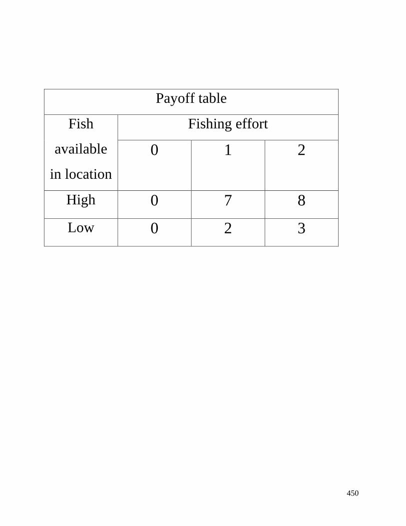
450
Payoff table
Fish
available
in location
Fishing effort
0 1 2
High 0 7 8
Low 0 2 3
451
Voting card Voting card
Player number 1 Player number 1
I vote for the rule
number
I vote for the rule
number
Voting card Voting card
Player number 2 Player number 2
I vote for the rule
number
I vote for the rule
number
Voting card Voting card
Player number 3 Player number 3
I vote for the rule
number
I vote for the rule
number
Voting card Voting card
Player number 4 Player number 4
I vote for the rule
number
I vote for the rule
number
Voting card Voting card
Player number 5 Player number 5
I vote for the rule I vote for the rule

452
number number
453
Player calculation sheet
Player no: Time:
Place:
Date:
Round A B C
My Decisions My points
Place Effort
(A/B) (0,1,2)
Practice 1
Practice 2
Practice 3
1
2
3
4
5
6
7
8
9
10
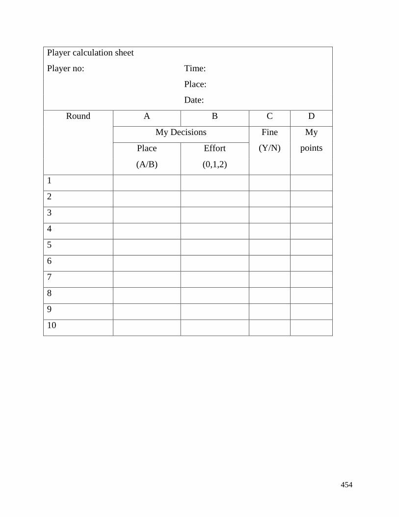
454
Player calculation sheet
Player no: Time:
Place:
Date:
Round A B C D
My Decisions Fine
(Y/N)
My
points Place Effort
(A/B) (0,1,2)
1
2
3
4
5
6
7
8
9
10
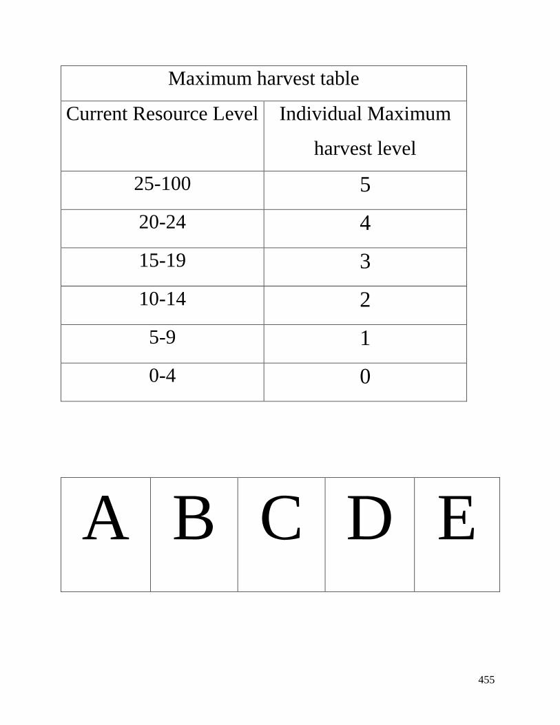
455
Maximum harvest table
Current Resource Level Individual Maximum
harvest level
25-100 5
20-24 4
15-19 3
10-14 2
5-9 1
0-4 0
A B C D E

456
1 2 3 4 5

457
Player calculation sheet
Player no: Time:
Place:
Date:
Round My Harvest Decision
Practice 1
Practice 2
Practice 3
1
2
3
4
5
6
7
8
9
10
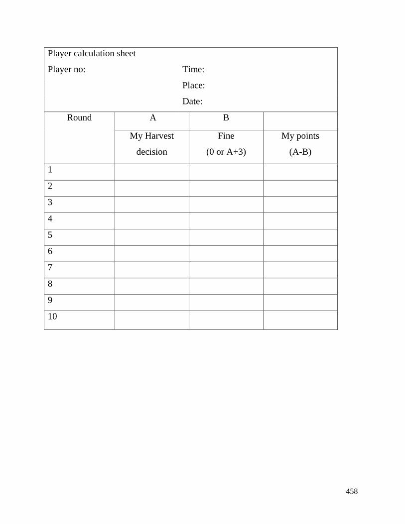
458
Player calculation sheet
Player no: Time:
Place:
Date:
Round A B
My Harvest
decision
Fine
(0 or A+3)
My points
(A-B)
1
2
3
4
5
6
7
8
9
10
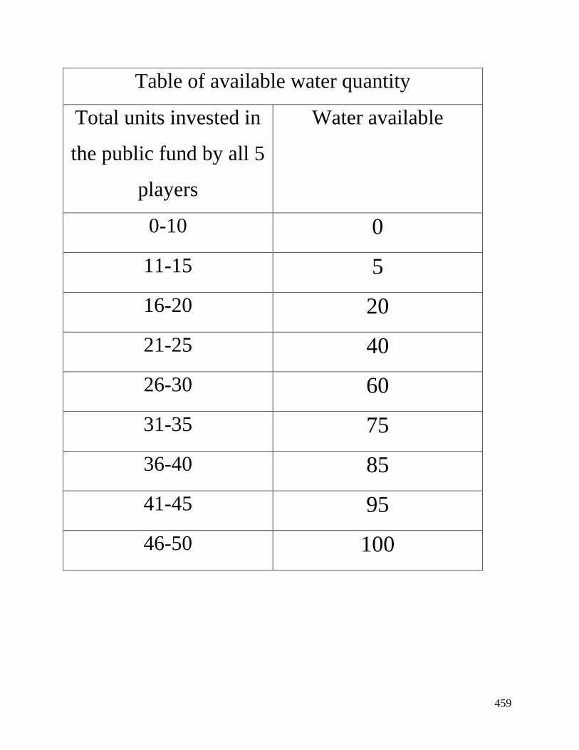
459
Table of available water quantity
Total units invested in
the public fund by all 5
players
Water available
0-10 0
11-15 5
16-20 20
21-25 40
26-30 60
31-35 75
36-40 85
41-45 95
46-50 100
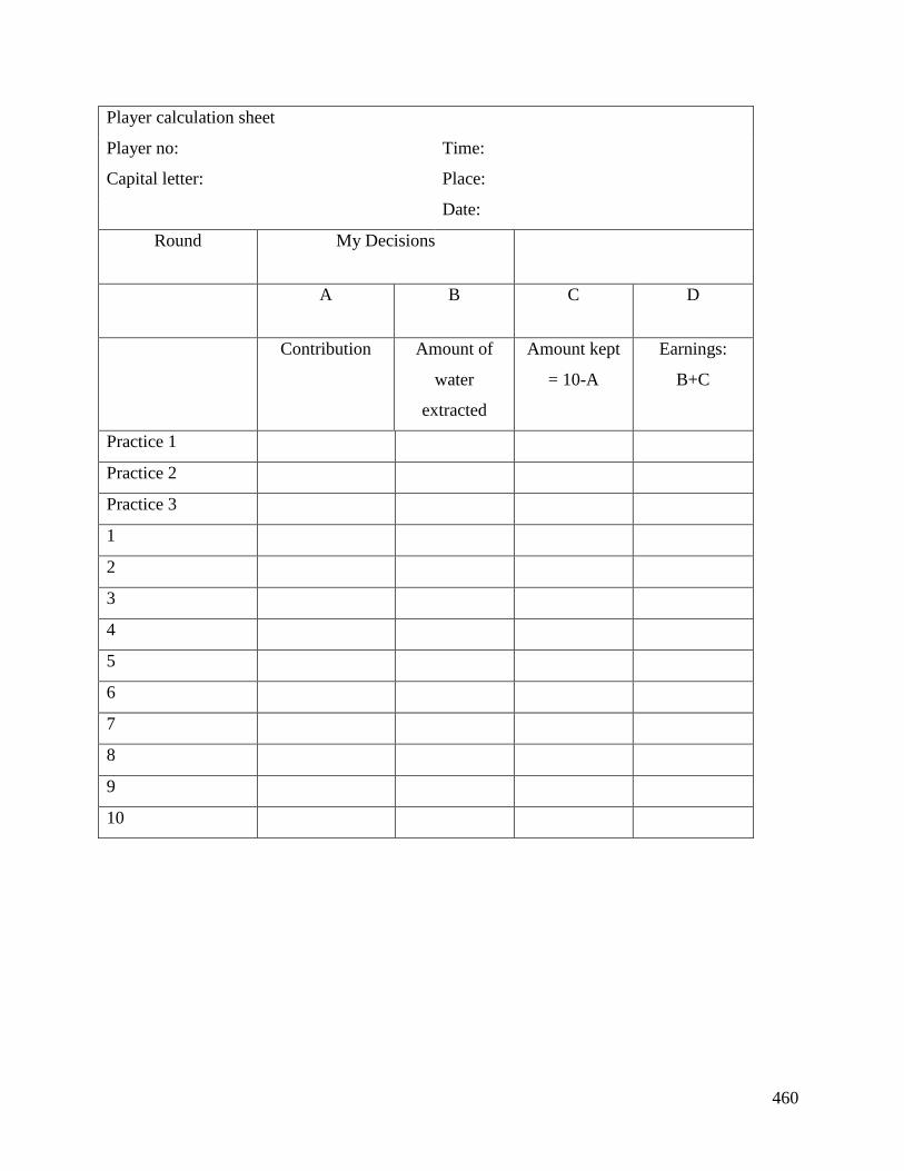
460
Player calculation sheet
Player no:
Capital letter:
Time:
Place:
Date:
Round My Decisions
A B C D
Contribution Amount of
water
extracted
Amount kept
= 10-A
Earnings:
B+C
Practice 1
Practice 2
Practice 3
1
2
3
4
5
6
7
8
9
10
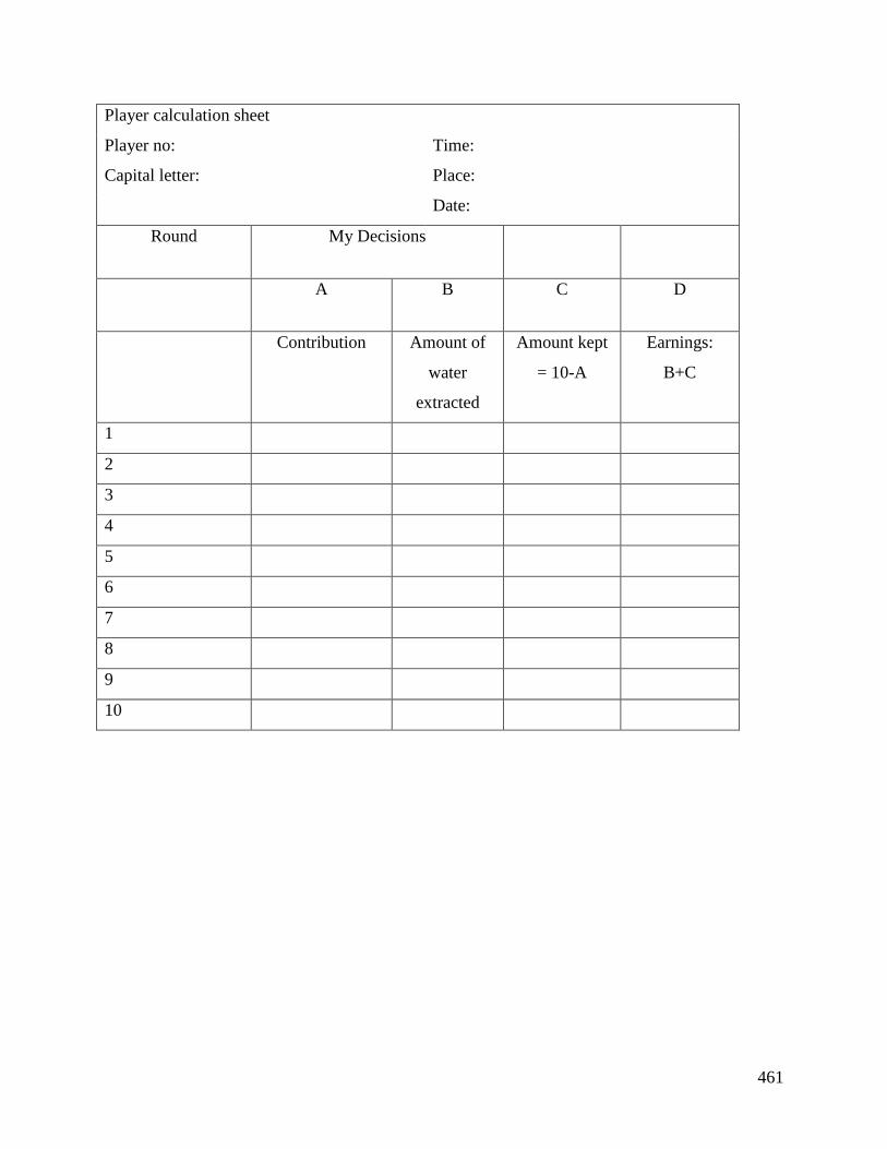
461
Player calculation sheet
Player no:
Capital letter:
Time:
Place:
Date:
Round My Decisions
A B C D
Contribution Amount of
water
extracted
Amount kept
= 10-A
Earnings:
B+C
1
2
3
4
5
6
7
8
9
10
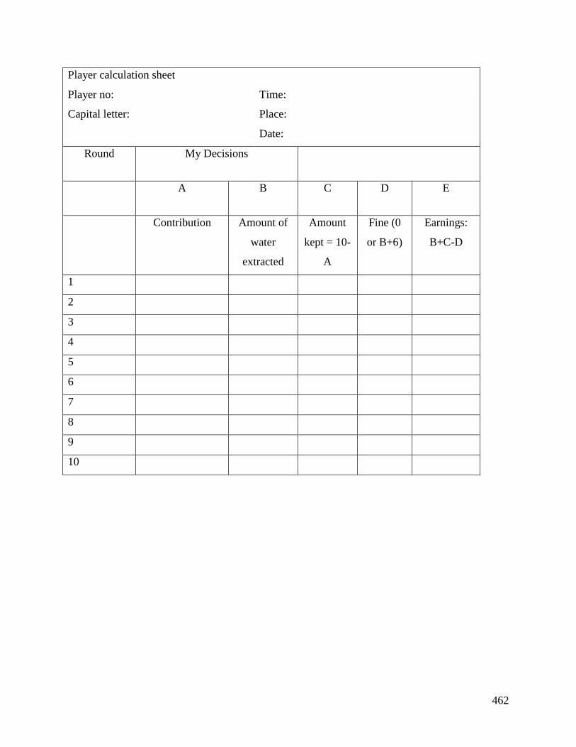
462
Player calculation sheet
Player no:
Capital letter:
Time:
Place:
Date:
Round My Decisions
A B C D E
Contribution Amount of
water
extracted
Amount
kept = 10-
A
Fine (0
or B+6)
Earnings:
B+C-D
1
2
3
4
5
6
7
8
9
10

463
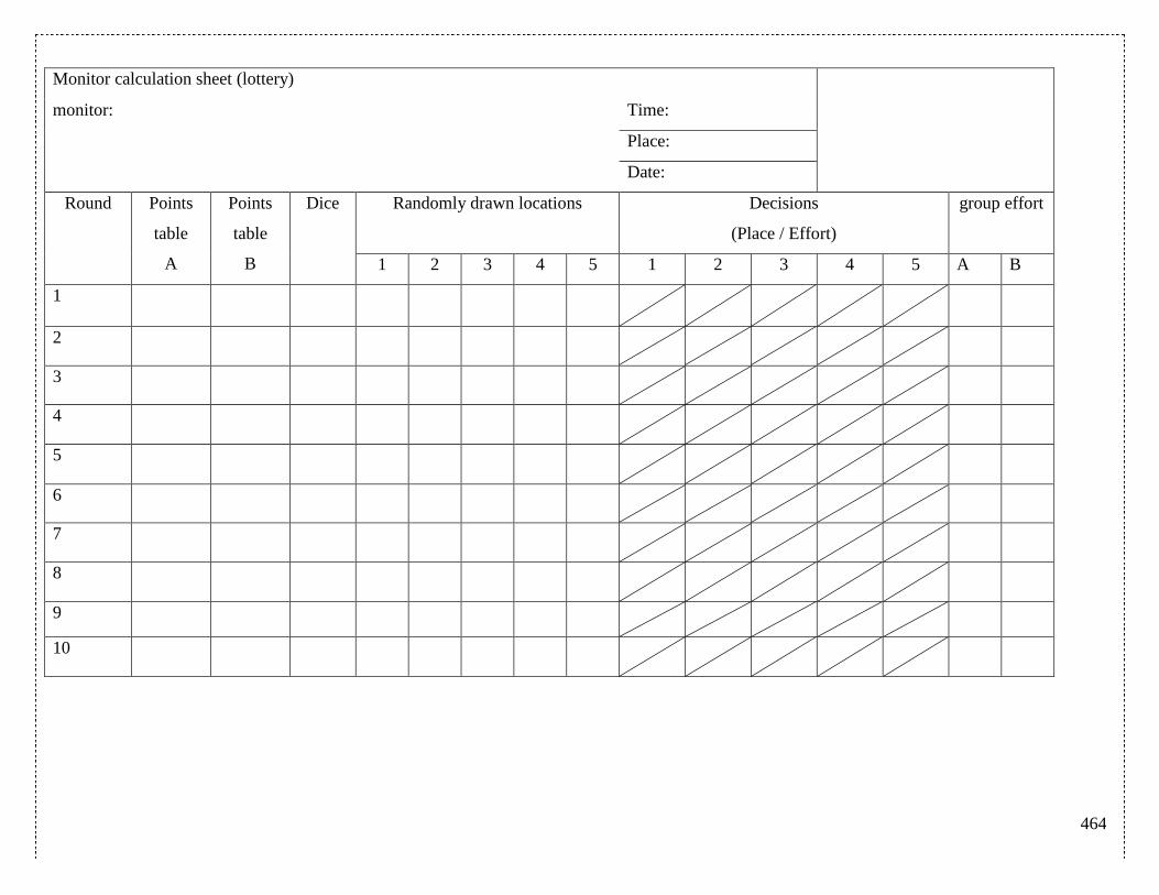
464
Monitor calculation sheet (lottery)
monitor: Time:
Place:
Date:
Round Points
table
A
Points
table
B
Dice Randomly drawn locations Decisions
(Place / Effort)
group effort
1 2 3 4 5 1 2 3 4 5 A B
1
2
3
4
5
6
7
8
9
10
465
Monitor calculation sheet (rotation of banning)
monitor: Time:
Place:
Date:
Round Points
table
A
Points
table
B
Dice Banned location Decisions
(Place / Effort)
Group effort
1 2 3 4 5 A B
1 A
2 A
3 B
4 B
5 A
6 A
7 B
8 B
9 A
10 A
466
Monitor calculation sheet (maximum 1 unit of effort)
monitor: Time:
Place:
Date:
Round Points table
A
Points table
B
Dice
(6? Yes or no)
Decisions
(Place / Effort)
Group effort
1 2 3 4 5 A B
1
2
3
4
5
6
7
8
9
10
467
Monitor calculation sheet Votes No. Rule
monitor: Time: 1 2 3
Place: Round 1
Date: Round 2
Round Points
table
A
Points table
B
Decisions
(Place / Effort)
C
group effort
1 2 3 4 5 A B
Pract 1
Pract 2
Pract 3
1
2
3
4
5
6
7
8
9
10
468
Monitor calculation sheet Votes Rule numbers
monitor: Time: 1 2 3
Place: Round 1
Date: Round 2
Round Resource
size
(A)
Maximum
individual
harvest level
Harvest decisions B C
1 2 3 4 5 Group total
forest
Remaining
forest
(A-B)
Regrowth of
forest
(0.1*C)
Pract 1
Pract 2
Pract 3
1
2
3
4
5
6
7
8
9
10
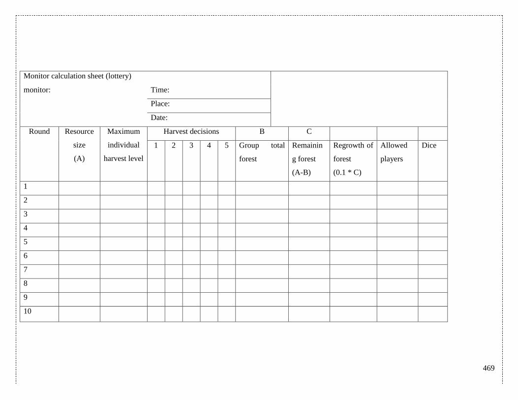
469
Monitor calculation sheet (lottery)
monitor: Time:
Place:
Date:
Round Resource
size
(A)
Maximum
individual
harvest level
Harvest decisions B C
1 2 3 4 5 Group total
forest
Remainin
g forest
(A-B)
Regrowth of
forest
(0.1 * C)
Allowed
players
Dice
1
2
3
4
5
6
7
8
9
10
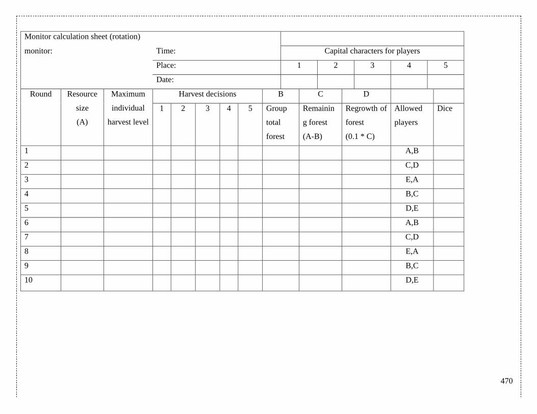
470
Monitor calculation sheet (rotation)
monitor: Time: Capital characters for players
Place: 1 2 3 4 5
Date:
Round Resource
size
(A)
Maximum
individual
harvest level
Harvest decisions B C D
1 2 3 4 5 Group
total
forest
Remainin
g forest
(A-B)
Regrowth of
forest
(0.1 * C)
Allowed
players
Dice
1 A,B
2 C,D
3 E,A
4 B,C
5 D,E
6 A,B
7 C,D
8 E,A
9 B,C
10 D,E

471
Monitor calculation sheet (maximum harvest 2)
monitor: Time:
Place:
Date:
Round Resource
size
(A)
Maximum
individual
harvest level
Harvest decisions B C
1 2 3 4 5 Group
total forest
Remaining
forest
(A-B)
Regrowth of
forest
(0.1 * C)
Dice
1
2
3
4
5
6
7
8
9
10
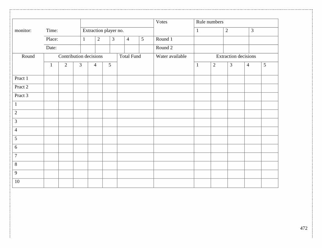
472
Votes Rule numbers
monitor: Time: Extraction player no. 1 2 3
Place: 1 2 3 4 5 Round 1
Date: Round 2
Round Contribution decisions Total Fund Water available Extraction decisions
1 2 3 4 5 1 2 3 4 5
Pract 1
Pract 2
Pract 3
1
2
3
4
5
6
7
8
9
10
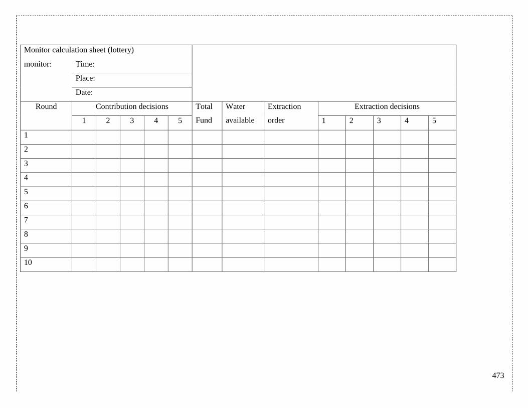
473
Monitor calculation sheet (lottery)
monitor: Time:
Place:
Date:
Round Contribution decisions Total
Fund
Water
available
Extraction
order
Extraction decisions
1 2 3 4 5 1 2 3 4 5
1
2
3
4
5
6
7
8
9
10
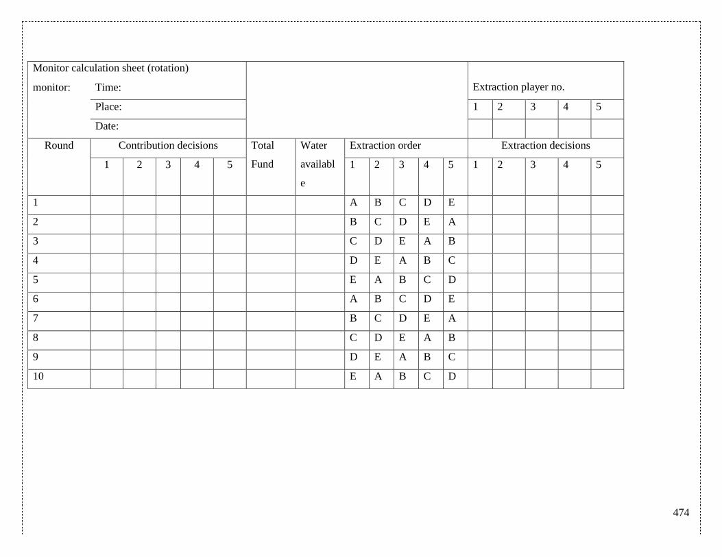
474
Monitor calculation sheet (rotation)
Extraction player no. monitor: Time:
Place: 1 2 3 4 5
Date:
Round Contribution decisions Total
Fund
Water
availabl
e
Extraction order Extraction decisions
1 2 3 4 5 1 2 3 4 5 1 2 3 4 5
1 A B C D E
2 B C D E A
3 C D E A B
4 D E A B C
5 E A B C D
6 A B C D E
7 B C D E A
8 C D E A B
9 D E A B C
10 E A B C D
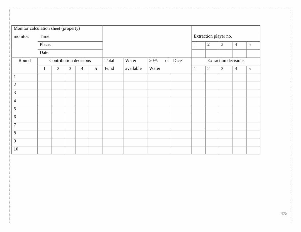
475
Monitor calculation sheet (property)
Extraction player no. monitor: Time:
Place: 1 2 3 4 5
Date:
Round Contribution decisions Total
Fund
Water
available
20% of
Water
Dice Extraction decisions
1 2 3 4 5 1 2 3 4 5
1
2
3
4
5
6
7
8
9
10
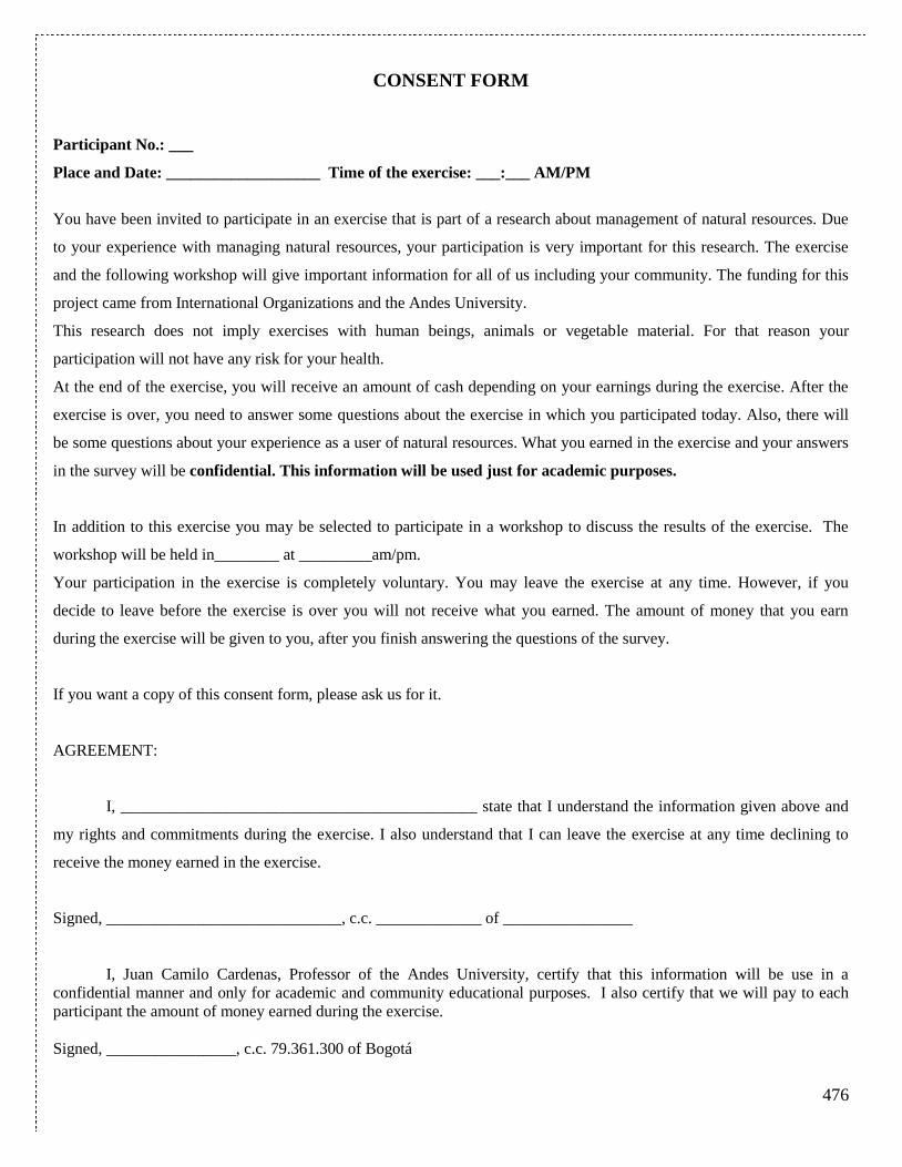
476
CONSENT FORM
Participant No.: ___
Place and Date: ___________________ Time of the exercise: ___:___ AM/PM
You have been invited to participate in an exercise that is part of a research about management of natural resources. Due
to your experience with managing natural resources, your participation is very important for this research. The exercise
and the following workshop will give important information for all of us including your community. The funding for this
project came from International Organizations and the Andes University.
This research does not imply exercises with human beings, animals or vegetable material. For that reason your
participation will not have any risk for your health.
At the end of the exercise, you will receive an amount of cash depending on your earnings during the exercise. After the
exercise is over, you need to answer some questions about the exercise in which you participated today. Also, there will
be some questions about your experience as a user of natural resources. What you earned in the exercise and your answers
in the survey will be confidential. This information will be used just for academic purposes.
In addition to this exercise you may be selected to participate in a workshop to discuss the results of the exercise. The
workshop will be held in________ at _________am/pm.
Your participation in the exercise is completely voluntary. You may leave the exercise at any time. However, if you
decide to leave before the exercise is over you will not receive what you earned. The amount of money that you earn
during the exercise will be given to you, after you finish answering the questions of the survey.
If you want a copy of this consent form, please ask us for it.
AGREEMENT:
I, ____________________________________________ state that I understand the information given above and
my rights and commitments during the exercise. I also understand that I can leave the exercise at any time declining to
receive the money earned in the exercise.
Signed, _____________________________, c.c. _____________ of ________________
I, Juan Camilo Cardenas, Professor of the Andes University, certify that this information will be use in a
confidential manner and only for academic and community educational purposes. I also certify that we will pay to each
participant the amount of money earned during the exercise.
Signed, ________________, c.c. 79.361.300 of Bogotá
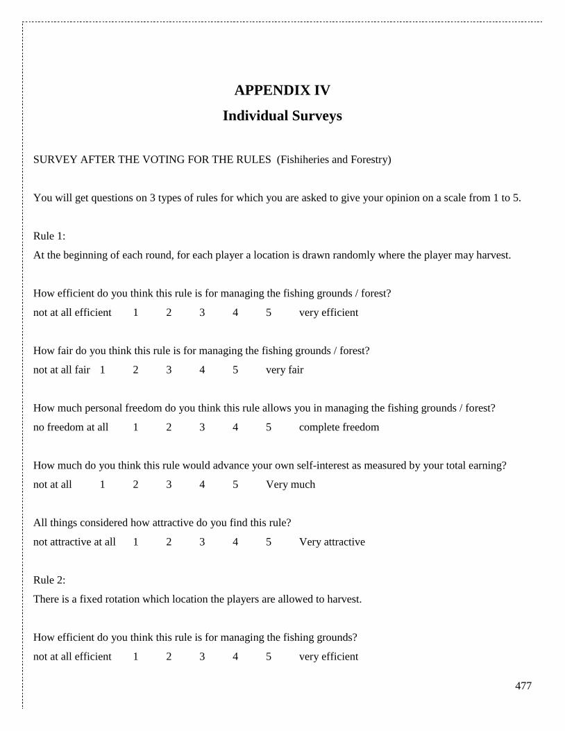
477
APPENDIX IV
Individual Surveys
SURVEY AFTER THE VOTING FOR THE RULES (Fishiheries and Forestry)
You will get questions on 3 types of rules for which you are asked to give your opinion on a scale from 1 to 5.
Rule 1:
At the beginning of each round, for each player a location is drawn randomly where the player may harvest.
How efficient do you think this rule is for managing the fishing grounds / forest?
not at all efficient 1 2 3 4 5 very efficient
How fair do you think this rule is for managing the fishing grounds / forest?
not at all fair 1 2 3 4 5 very fair
How much personal freedom do you think this rule allows you in managing the fishing grounds / forest?
no freedom at all 1 2 3 4 5 complete freedom
How much do you think this rule would advance your own self-interest as measured by your total earning?
not at all 1 2 3 4 5 Very much
All things considered how attractive do you find this rule?
not attractive at all 1 2 3 4 5 Very attractive
Rule 2:
There is a fixed rotation which location the players are allowed to harvest.
How efficient do you think this rule is for managing the fishing grounds?
not at all efficient 1 2 3 4 5 very efficient
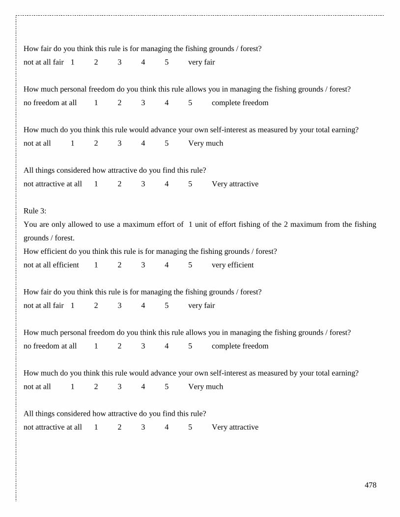
478
How fair do you think this rule is for managing the fishing grounds / forest?
not at all fair 1 2 3 4 5 very fair
How much personal freedom do you think this rule allows you in managing the fishing grounds / forest?
no freedom at all 1 2 3 4 5 complete freedom
How much do you think this rule would advance your own self-interest as measured by your total earning?
not at all 1 2 3 4 5 Very much
All things considered how attractive do you find this rule?
not attractive at all 1 2 3 4 5 Very attractive
Rule 3:
You are only allowed to use a maximum effort of 1 unit of effort fishing of the 2 maximum from the fishing
grounds / forest.
How efficient do you think this rule is for managing the fishing grounds / forest?
not at all efficient 1 2 3 4 5 very efficient
How fair do you think this rule is for managing the fishing grounds / forest?
not at all fair 1 2 3 4 5 very fair
How much personal freedom do you think this rule allows you in managing the fishing grounds / forest?
no freedom at all 1 2 3 4 5 complete freedom
How much do you think this rule would advance your own self-interest as measured by your total earning?
not at all 1 2 3 4 5 Very much
All things considered how attractive do you find this rule?
not attractive at all 1 2 3 4 5 Very attractive
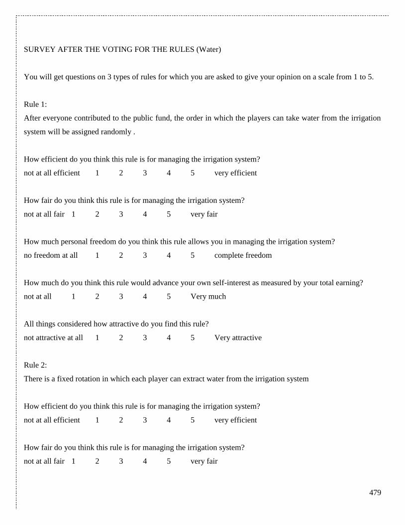
479
SURVEY AFTER THE VOTING FOR THE RULES (Water)
You will get questions on 3 types of rules for which you are asked to give your opinion on a scale from 1 to 5.
Rule 1:
After everyone contributed to the public fund, the order in which the players can take water from the irrigation
system will be assigned randomly .
How efficient do you think this rule is for managing the irrigation system?
not at all efficient 1 2 3 4 5 very efficient
How fair do you think this rule is for managing the irrigation system?
not at all fair 1 2 3 4 5 very fair
How much personal freedom do you think this rule allows you in managing the irrigation system?
no freedom at all 1 2 3 4 5 complete freedom
How much do you think this rule would advance your own self-interest as measured by your total earning?
not at all 1 2 3 4 5 Very much
All things considered how attractive do you find this rule?
not attractive at all 1 2 3 4 5 Very attractive
Rule 2:
There is a fixed rotation in which each player can extract water from the irrigation system
How efficient do you think this rule is for managing the irrigation system?
not at all efficient 1 2 3 4 5 very efficient
How fair do you think this rule is for managing the irrigation system?
not at all fair 1 2 3 4 5 very fair

480
How much personal freedom do you think this rule allows you in managing the irrigation system?
no freedom at all 1 2 3 4 5 complete freedom
How much do you think this rule would advance your own self-interest as measured by your total earning?
not at all 1 2 3 4 5 Very much
All things considered how attractive do you find this rule?
not attractive at all 1 2 3 4 5 Very attractive
Rule 3:
Each player has a right of one fifth of the water. The order to collect units remains the same for all the rounds:
ABCDE. A random number between 1 and 6 is drawn, and when a 6 is drawn, players who take more than
allowed have to pay this back, plus a penalty of 6 units.
How efficient do you think this rule is for managing the irrigation system?
not at all efficient 1 2 3 4 5 very efficient
How fair do you think this rule is for managing the irrigation system?
not at all fair 1 2 3 4 5 very fair
How much personal freedom do you think this rule allows you in managing the irrigation system?
no freedom at all 1 2 3 4 5 complete freedom
How much do you think this rule would advance your own self-interest as measured by your total earning?
not at all 1 2 3 4 5 Very much
All things considered how attractive do you find this rule?
not attractive at all 1 2 3 4 5 Very attractive
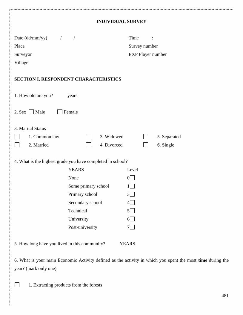
481
INDIVIDUAL SURVEY
Date (dd/mm/yy) / / Time :
Place Survey number
Surveyor EXP Player number
Village
SECTION I. RESPONDENT CHARACTERISTICS
1. How old are you? years
2. Sex Male Female
3. Marital Status
1. Common law 3. Widowed 5. Separated
2. Married 4. Divorced 6. Single
4. What is the highest grade you have completed in school?
YEARS Level
None 0
Some primary school 1
Primary school 3
Secondary school 4
Technical 5
University 6
Post-university 7
5. How long have you lived in this community? YEARS
6. What is your main Economic Activity defined as the activity in which you spent the most time during the
year? (mark only one)
1. Extracting products from the forests
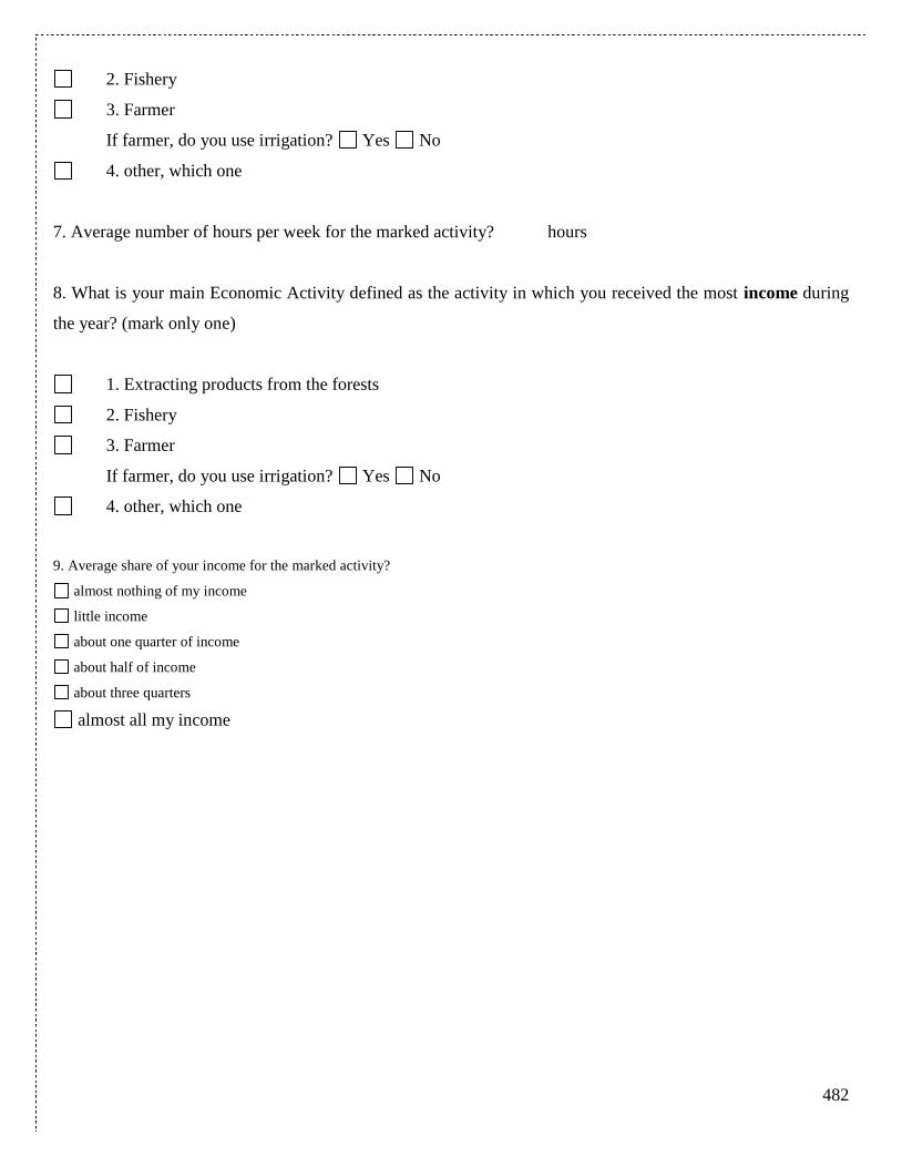
482
2. Fishery
3. Farmer
If farmer, do you use irrigation? Yes No
4. other, which one
7. Average number of hours per week for the marked activity? hours
8. What is your main Economic Activity defined as the activity in which you received the most income during
the year? (mark only one)
1. Extracting products from the forests
2. Fishery
3. Farmer
If farmer, do you use irrigation? Yes No
4. other, which one
9. Average share of your income for the marked activity?
almost nothing of my income
little income
about one quarter of income
about half of income
about three quarters
almost all my income

483
SECTION II. HOUSEHOLD CHARACTERISTICS
1. Number of people (adults and children) in your household including yourself
2. How long has your family (ancestors) lived in this community? YEARS
3. Have you or any in your household participated in voluntary work related to managing,
conserving, or monitoring the common pool of natural resources in your village during the
last year?
Yes, how many days per year? No
4. The dwelling that this household occupies is:
1. Owned and totally paid for
2. Owned and being paid for
3. Inheritance or gift
4. Right of possession
5. Rented
6. Transferred or loaned
7. Other form
5. Are you or anyone from your household the owner of this land you live in?
Yes. How many hectares (acres)?
No
484
SECTION III. COLLECTIVE ACTION
1. Please tell me whether in general you agree or disagree with the following statements:
1 Strongly Agree 2 Agree 3 Disagree 4 Strongly disagree
1. Most people in this village are basically honest and can be
trusted. 1. 2. 3. 4.
2. People in this village are mostly interested in their own well-
being
1. 2. 3. 4.
3. Members of this village are always more trustworthy than
those in other villages. 1. 2. 3. 4.
4. In this village one has to be alert, or someone will take
advantage of you. 1. 2. 3. 4.
5. If I have a problem there is always someone in this village to
help you.
1. 2. 3. 4.
6. I do not pay attention to the opinions of others in the village. 1. 2. 3. 4.
7. Most people in this village are willing to help if you need it. 1. 2. 3. 4.
8. This village has prospered in the last five years. 1. 2. 3. 4.
9. I feel accepted as a member of this village
1. 2. 3. 4.
10. If you lose a pig or chicken someone in the village would
help look for it or would return it to you. 1. 2. 3. 4.
2. How much influence do you think people like yourself can have in making this village a
better place to live?
1. A lot
2. Some
3. Not very much
4. None
485
5. Don’t know/not sure
3. If there was a problem related to natural resource use in this community, how likely is
that people will cooperate to try to solve the problem?
1. Very likely
2. Somewhat likely
3. Neither likely nor unlikely
4. Somewhat unlikely
5. Very unlikely
4. How often in the past year have you joined others in the village to address a issue related
to the use of a common resource, like ?
Fishery Water management
Forest
1. Never
2. Once
3. A couple of times
4. Frequently
5. Give examples of these activities?
-
-
-
486
SECTION IV. QUESTIONS AFTER THE EXERCISES
1. How satisfied were you with the earnings during the exercises?
1. I was completely dissatisfied
2. I was not satisfied
3. I was somewhat satisfied
4. I was satisfied
5. I was very satisfied
2. Did you understand the instructions of the exercises?
1. I did not understood anything
2. I did understand only a bit of the instructions
3. I did understood half of the instructions
4. I did understood most of the instructions
5. I did understood everything
3. Were you paying attention to the behavior of the other participants?
yes no
4. Were your decisions influenced by behavior of others?
yes no
5. If you had the chance to return to the start of the 2nd
stage, right before we changed the
rules of the game to lottery/rotation/property rights, would you have preferred to maintain
the rules unchanged and continue playing the same way as in the 1st stage?
yes, I would have preferred not changing the rules for the 2nd
stage.
no, I would have preferred to have the rules changed to the rule we in fact used.
no, I would have preferred to have the rules change to another rule
(Describe here)_____________________________________________________
__________________________________________________________________
487
__________________________________________________________________
6. Does this exercises represent in a simplified form any experiences you have faced in this
village?
1. Nothing at all
2. A little bit
3. More or less
4. Yes, in a major way
5. Yes, completely
Do you have some final remarks on the exercises? You can write them here:
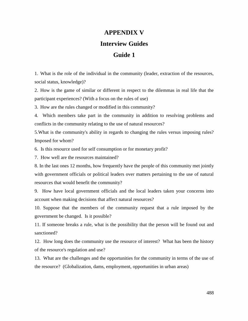
488
APPENDIX V
Interview Guides
Guide 1
1. What is the role of the individual in the community (leader, extraction of the resources,
social status, knowledge)?
2. How is the game of similar or different in respect to the dilemmas in real life that the
participant experiences? (With a focus on the rules of use)
3. How are the rules changed or modified in this community?
4. Which members take part in the community in addition to resolving problems and
conflicts in the community relating to the use of natural resources?
5.What is the community's ability in regards to changing the rules versus imposing rules?
Imposed for whom?
6. Is this resource used for self consumption or for monetary profit?
7. How well are the resources maintained?
8. In the last ones 12 months, how frequently have the people of this community met jointly
with government officials or political leaders over matters pertaining to the use of natural
resources that would benefit the community?
9. How have local government officials and the local leaders taken your concerns into
account when making decisions that affect natural resources?
10. Suppose that the members of the community request that a rule imposed by the
government be changed. Is it possible?
11. If someone breaks a rule, what is the possibility that the person will be found out and
sanctioned?
12. How long does the community use the resource of interest? What has been the history
of the resource's regulation and use?
13. What are the challenges and the opportunities for the community in terms of the use of
the resource? (Globalization, dams, employment, opportunities in urban areas)
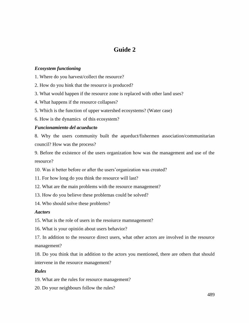
489
Guide 2
Ecosystem functioning
1. Where do you harvest/collect the resource?
2. How do you hink that the resource is produced?
3. What would happen if the resource zone is replaced with other land uses?
4. What happens if the resource collapses?
5. Which is the function of upper watershed ecosystems? (Water case)
6. How is the dynamics of this ecosystem?
Funcionamiento del acueducto
8. Why the users community built the aqueduct/fishermen association/communitarian
council? How was the process?
9. Before the existence of the users organization how was the management and use of the
resource?
10. Was it better before or after the users’organization was created?
11. For how long do you think the resource will last?
12. What are the main problems with the resource management?
13. How do you believe these problemas could be solved?
14. Who should solve these problems?
Aactors
15. What is the role of users in the resoiurce mamnagement?
16. What is your opinión about users behavior?
17. In addition to the resource direct users, what other actors are involved in the resource
management?
18. Do you think that in addition to the actors you mentioned, there are others that should
intervene in the resource management?
Rules
19. What are the rules for resource management?
20. Do your neighbours follow the rules?
490
25. Does everybody follow the rules?
26. Do you follow the rules?
27 What happens if someone does not follow the rules?
28. Who is in charge of monitoring rules compliance?
29. How is the monitoring working?
30. Do you think rule monitoring must change or not?
31. Is it better that someone from the community monitor sor someone external?
32. What happens if someone does not follow the rules?
33. In case of resource scarcity people would follow the rules that control the extraction?
34. Would you denounce someone that does not follows the rules?
35. Whaqt happens when someone break the rules and other persons know the infraction?
36. Her, usually people trust in the others?
37. Do you trust in the others?
38. Do you think that others trust in you?
39. When there are problems with the resource, people cooperate? How?
40. Who has property rigths of the resource?
41. Is there some relation between productive activities and the resource use?
42. Young people are more likely to stay in the village or they try to leave the zone?
43. How this relation affects the resource maintenance?
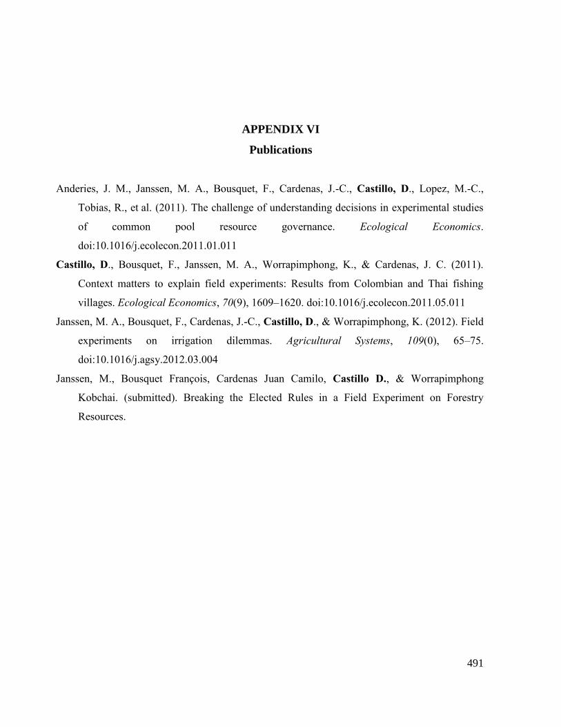
491
APPENDIX VI
Publications
Anderies, J. M., Janssen, M. A., Bousquet, F., Cardenas, J.-C., Castillo, D., Lopez, M.-C.,
Tobias, R., et al. (2011). The challenge of understanding decisions in experimental studies
of common pool resource governance. Ecological Economics.
doi:10.1016/j.ecolecon.2011.01.011
Castillo, D., Bousquet, F., Janssen, M. A., Worrapimphong, K., & Cardenas, J. C. (2011).
Context matters to explain field experiments: Results from Colombian and Thai fishing
villages. Ecological Economics, 70(9), 1609–1620. doi:10.1016/j.ecolecon.2011.05.011
Janssen, M. A., Bousquet, F., Cardenas, J.-C., Castillo, D., & Worrapimphong, K. (2012). Field
experiments on irrigation dilemmas. Agricultural Systems, 109(0), 65–75.
doi:10.1016/j.agsy.2012.03.004
Janssen, M., Bousquet François, Cardenas Juan Camilo, Castillo D., & Worrapimphong
Kobchai. (submitted). Breaking the Elected Rules in a Field Experiment on Forestry
Resources.
492
ABSTRACT
The main question that addresses this research is about the role of mental models in
the institutional arrangements for common pool resource management. The central
idea is that there is a cognitive conflict when different actors define use and
management problems of common pool resources. Mental models are used for
institutional design. Several actors, to structure commons problems, use different
mental models. Mental models influence institutions and policies intended to solve
such problems. The conceptual framework of the study included commons
dilemmas, neo institutionalism approaches, institutional analysis and development
(IAD) socio ecological systems and mental models concepts. Three case studies in
Colombia (South America) were chosed to study the above question: an artisanal
fishermen place in Caribbean (Barú), a communitarian aqueduct in the Andes
(Lenguazque), and a forestry community in the Pacific coast (Salahonda). In order
to explore the research question a multimethod framework was designed that
included a first phase of economic experiments, surveys and interviews with
resource users. The experiments were designed to capture the commons dilemma in
each case: fishing, water and forestry. These experiemnts simulated also the
dynamic complexity of each of the resources. The experiments also simulated three
types of voted rules as solution to the cooperation dilemma. Resource users from
the three case studies participated in the experiments. A second field phase was
carried out using the companion modeling approach (ComMod) approach. The
experimental setting was used to start a co-construction of a role playing game with
a group of users in each village. Once the new game was designed a group of users
were invited to play the new game. Additionally, a new set of interviews was
applied. An institutional analysis and a mental models study was carried out for
each of the cases. The evaluative criteria of the action arena were trust and
cooperation levels and morality conformance. Among the more relevant findings is
the necessity of including the study of morality systems to understand the relation
between decision-making, rule design and compliance, and mental models. A
conceptual framework for evaluate the outcomes of the action arena is proposed.
The central point is the idea that the morality system is at the same time an outcome
of interactions, but also it feedsback the interactions in the action arena. This system
produces especific levels of trust and cooperation, which are also influenced by
contextual mental models of resource users. In order to address commons
management is central to understand the gap between morality, culture and legal
valid behavior in a community.

493
RÉSUMÉ