SUBDIVISION REGS COVER PAGE
40
TOWN OF WILLIAMSTON, NORTH CAROLINA John T. Boykin, Jr. Town Administrator Daniel a. manning town attorney Donald w. Christopher zoning administrator SUBDIVISION REGULATIONS ADOPTED April 6, 1992
Transcript of SUBDIVISION REGS COVER PAGE

TOWN OF WILLIAMSTON, NORTH CAROLINA
John T. Boykin, Jr. Town Administrator
Daniel a. manning town attorney
Donald w. Christopher zoning administrator
SUBDIVISION REGULATIONS
ADOPTED April 6, 1992
i
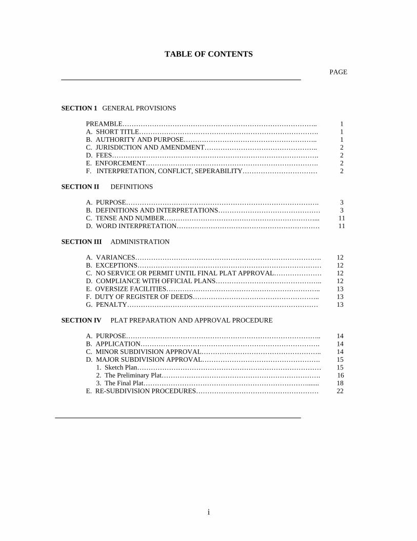
TABLE OF CONTENTS
PAGE
SECTION 1 GENERAL PROVISIONS PREAMBLE………………………………………………………………………….. 1 A. SHORT TITLE……………………………………………………………………. 1 B. AUTHORITY AND PURPOSE………………………………………………….. 1 C. JURISDICTION AND AMENDMENT………………………………………….. 2 D. FEES………………………………………………………………………………. 2 E. ENFORCEMENT…………………………………………………………………. 2 F. INTERPRETATION, CONFLICT, SEPERABILITY…………………………… 2 SECTION II DEFINITIONS A. PURPOSE…………………………………………………………………………. 3 B. DEFINITIONS AND INTERPRETATIONS……………………………………… 3 C. TENSE AND NUMBER…………………………………………………………... 11 D. WORD INTERPRETATION……………………………………………………… 11 SECTION III ADMINISTRATION A. VARIANCES………………………………………………………………………. 12 B. EXCEPTIONS……………………………………………………………………… 12 C. NO SERVICE OR PERMIT UNTIL FINAL PLAT APPROVAL………………… 12 D. COMPLIANCE WITH OFFICIAL PLANS……………………………………….. 12 E. OVERSIZE FACILITIES………………………………………………………….. 13 F. DUTY OF REGISTER OF DEEDS……………………………………………….. 13 G. PENALTY………………………………………………………………………… 13 SECTION IV PLAT PREPARATION AND APPROVAL PROCEDURE A. PURPOSE………………………………………………………………………….. 14 B. APPLICATION……………………………………………………………………. 14 C. MINOR SUBDIVISION APPROVAL…………………………………………….. 14 D. MAJOR SUBDIVISION APPROVAL……………………………………………. 15 1. Sketch Plan……………………………………………………………………… 15 2. The Preliminary Plat……………………………………………………………. 16 3. The Final Plat………………………………………………………………....... 18 E. RE-SUBDIVISION PROCEDURES……………………………………………… 22
ii
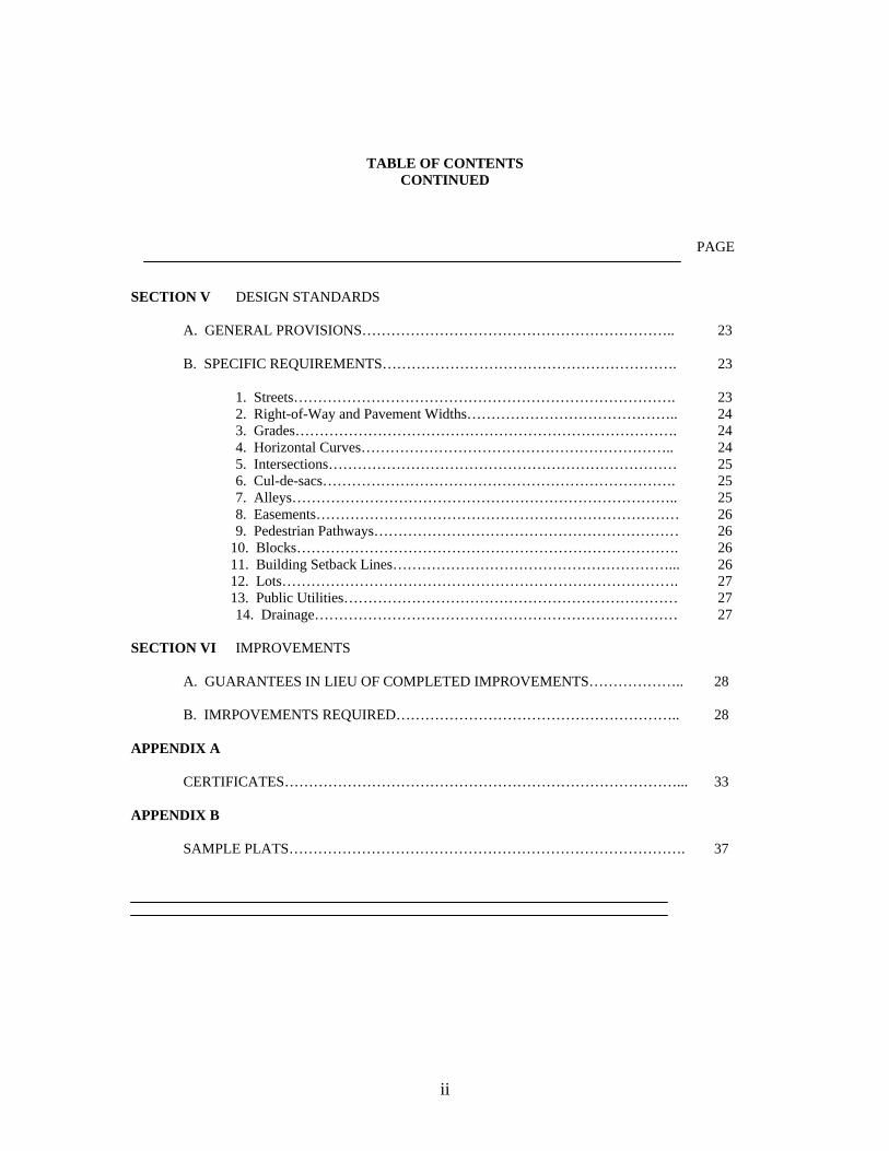
TABLE OF CONTENTS CONTINUED
PAGE
SECTION V DESIGN STANDARDS A. GENERAL PROVISIONS……………………………………………………….. 23 B. SPECIFIC REQUIREMENTS……………………………………………………. 23 1. Streets……………………………………………………………………. 23 2. Right-of-Way and Pavement Widths…………………………………….. 24 3. Grades……………………………………………………………………. 24 4. Horizontal Curves……………………………………………………….. 24 5. Intersections……………………………………………………………… 25 6. Cul-de-sacs………………………………………………………………. 25 7. Alleys…………………………………………………………………….. 25 8. Easements………………………………………………………………… 26 9. Pedestrian Pathways……………………………………………………… 26 10. Blocks……………………………………………………………………. 26 11. Building Setback Lines…………………………………………………... 26 12. Lots………………………………………………………………………. 27 13. Public Utilities…………………………………………………………… 27 14. Drainage………………………………………………………………… 27 SECTION VI IMPROVEMENTS A. GUARANTEES IN LIEU OF COMPLETED IMPROVEMENTS……………….. 28 B. IMRPOVEMENTS REQUIRED………………………………………………….. 28 APPENDIX A CERTIFICATES………………………………………………………………………... 33 APPENDIX B SAMPLE PLATS………………………………………………………………………. 37
1
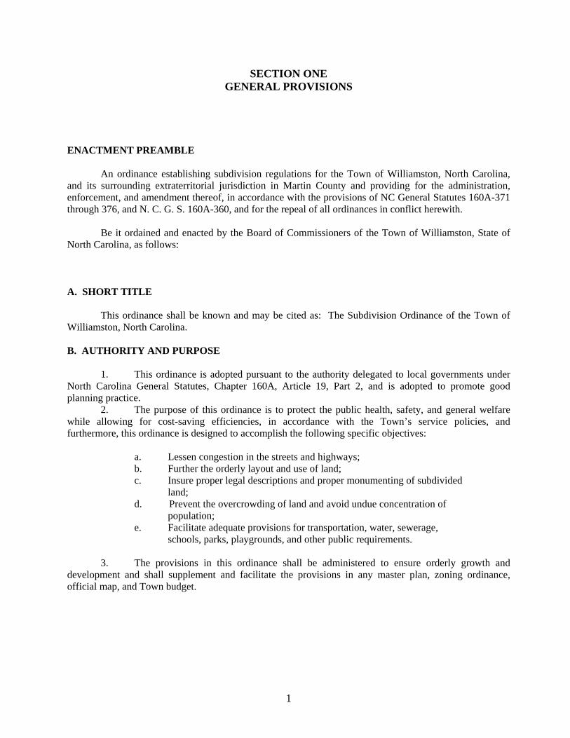
SECTION ONE GENERAL PROVISIONS
ENACTMENT PREAMBLE An ordinance establishing subdivision regulations for the Town of Williamston, North Carolina, and its surrounding extraterritorial jurisdiction in Martin County and providing for the administration, enforcement, and amendment thereof, in accordance with the provisions of NC General Statutes 160A-371 through 376, and N. C. G. S. 160A-360, and for the repeal of all ordinances in conflict herewith. Be it ordained and enacted by the Board of Commissioners of the Town of Williamston, State of North Carolina, as follows: A. SHORT TITLE This ordinance shall be known and may be cited as: The Subdivision Ordinance of the Town of Williamston, North Carolina. B. AUTHORITY AND PURPOSE 1. This ordinance is adopted pursuant to the authority delegated to local governments under North Carolina General Statutes, Chapter 160A, Article 19, Part 2, and is adopted to promote good planning practice. 2. The purpose of this ordinance is to protect the public health, safety, and general welfare while allowing for cost-saving efficiencies, in accordance with the Town’s service policies, and furthermore, this ordinance is designed to accomplish the following specific objectives: a. Lessen congestion in the streets and highways; b. Further the orderly layout and use of land; c. Insure proper legal descriptions and proper monumenting of subdivided land;
d. Prevent the overcrowding of land and avoid undue concentration of population;
e. Facilitate adequate provisions for transportation, water, sewerage, schools, parks, playgrounds, and other public requirements. 3. The provisions in this ordinance shall be administered to ensure orderly growth and development and shall supplement and facilitate the provisions in any master plan, zoning ordinance, official map, and Town budget.
2
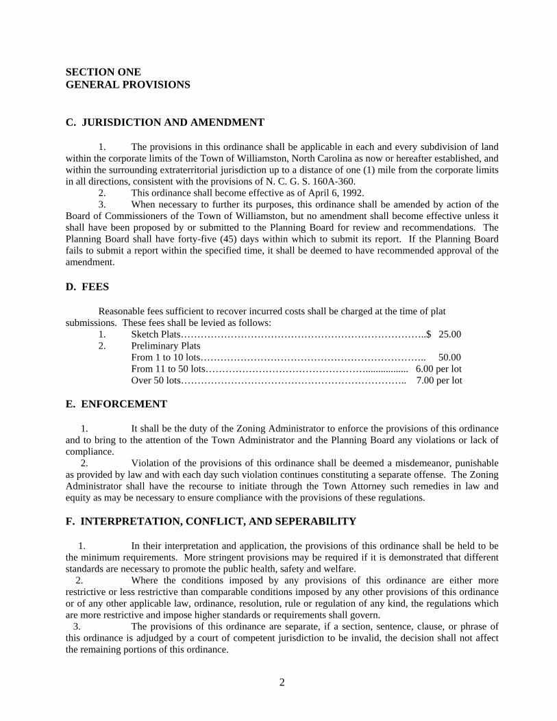
SECTION ONE GENERAL PROVISIONS C. JURISDICTION AND AMENDMENT 1. The provisions in this ordinance shall be applicable in each and every subdivision of land within the corporate limits of the Town of Williamston, North Carolina as now or hereafter established, and within the surrounding extraterritorial jurisdiction up to a distance of one (1) mile from the corporate limits in all directions, consistent with the provisions of N. C. G. S. 160A-360. 2. This ordinance shall become effective as of April 6, 1992. 3. When necessary to further its purposes, this ordinance shall be amended by action of the Board of Commissioners of the Town of Williamston, but no amendment shall become effective unless it shall have been proposed by or submitted to the Planning Board for review and recommendations. The Planning Board shall have forty-five (45) days within which to submit its report. If the Planning Board fails to submit a report within the specified time, it shall be deemed to have recommended approval of the amendment. D. FEES Reasonable fees sufficient to recover incurred costs shall be charged at the time of plat submissions. These fees shall be levied as follows: 1. Sketch Plats………………………………………………………………..$ 25.00 2. Preliminary Plats From 1 to 10 lots………………………………………………………….. 50.00 From 11 to 50 lots…………………………………………................. 6.00 per lot Over 50 lots………………………………………………………….. 7.00 per lot E. ENFORCEMENT 1. It shall be the duty of the Zoning Administrator to enforce the provisions of this ordinance and to bring to the attention of the Town Administrator and the Planning Board any violations or lack of compliance. 2. Violation of the provisions of this ordinance shall be deemed a misdemeanor, punishable as provided by law and with each day such violation continues constituting a separate offense. The Zoning Administrator shall have the recourse to initiate through the Town Attorney such remedies in law and equity as may be necessary to ensure compliance with the provisions of these regulations. F. INTERPRETATION, CONFLICT, AND SEPERABILITY 1. In their interpretation and application, the provisions of this ordinance shall be held to be the minimum requirements. More stringent provisions may be required if it is demonstrated that different standards are necessary to promote the public health, safety and welfare. 2. Where the conditions imposed by any provisions of this ordinance are either more restrictive or less restrictive than comparable conditions imposed by any other provisions of this ordinance or of any other applicable law, ordinance, resolution, rule or regulation of any kind, the regulations which are more restrictive and impose higher standards or requirements shall govern. 3. The provisions of this ordinance are separate, if a section, sentence, clause, or phrase of this ordinance is adjudged by a court of competent jurisdiction to be invalid, the decision shall not affect the remaining portions of this ordinance.
3
SECTION TWO DEFINITIONS
A. PURPOSE Unless otherwise expressly stated, the following terms shall, for the purposes of this ordinance, have the meaning herein indicated. B. DEFINITIONS Administrative Officer. The governmental officer charged with administering development regulations. Aisle. The traveled way by which cars enter and depart parking spaces. Alley. A public or private street primarily designed to serve as secondary access to the side or rear of those properties whose principal frontage is on some other street. Applicant. A developer submitting an application for development. Application. The application form and all accompanying documents required by ordinance for approval of a subdivision plat or site plan. Approving Authority. The Planning Board for some minor subdivisions or Board of Commissioners for all others, unless a different agency is designated by ordinance. Bicycle Lane. A lane at the edge of a roadway reserved and marked for the exclusive use of bicycles. Bicycle Path. A pathway usually separated from the roadway, designed specifically to satisfy the physical requirements of biking. Block. A parcel of land intended for urban purposes, which is entirely surrounded by public streets, highways, railroad right-of-ways, public walks, parks or green strips, rural land or drainage channels or a combination thereof. Buffer. An area within a property or site, generally adjacent to and parallel with the property line, either consisting of natural existing vegetation or created by the use of trees, shrubs, fences, or berms, designed to limit continuously the view of adjacent sites or properties. Building Setback Line. (See Setback). Channel. The bed and banks of a natural stream which convey the constant or intermittent flow of the stream. Cluster Development. A development approach in which building lots may be reduced in size and building sited closer together, usually in groups or clusters, provided that the total development density does not exceed that which could be constructed on the site under conventional zoning and subdivision regulations. The additional land that remains undeveloped is then preserved and maintained as open space or recreational land.
4
SECTION TWO DEFINITIONS Common Open Space. Land within or related to a development, not individually owned nor dedicated for public use, which is designed and intended for the common use or enjoyment of the residents of the development. It may include complementary structures and improvements. Construction Cul-de-Sac. A temporary, graveled circle with a minimum 35 foot width at the end of an unfinished street in an approved phased development and intended to provide interim vehicular circulation for a period not to exceed 5 years. Corner Lot. A lot abutting two (2) or more streets at the street intersections. Cul-de-Sac. A local street with only one outlet and having the other end for the reversal of traffic movement. See Street. Culvert. A structure designed to convey a watercourse not incorporated in a closed drainage system under a road or pedestrian walk. Curb. A vertical or sloping edge of a roadway. Dedication. An act transmitting property or interest thereto for a public purpose such as recreation areas or public rights-of-way in a subdivision. Density. The permitted number of dwelling units per gross acre of land to be developed. Design Standards. Standards that set forth specific improvement requirements. Detention Basin. A manmade or natural water collector facility designed to collect surface and subsurface water in order to impede its flow and to release the same gradually at a rate not greater that that prior to the development of the property, into natural or manmade outlets. Developer. The legal or beneficial owner or owners of a lot or of any land included in a proposed development. Also, the holder of an option or contract to purchase, or any other person having enforceable proprietary interest in such land. Development. A planning or construction project involving substantial property improvement and, usually, a change of land-use character within the site; the act of using land for building or extractive purposes. Development Regulation. Zoning, subdivision, site plan, official map, flood plan regulation, or other governmental regulation of the use and development of land. Double Frontage Lot. A continuous lot having the same depth as the width of the block and which is accessible from both streets upon which it fronts. Divided Street. A street having an island or other barrier separating moving lanes. Drainage. The removal of surface water or groundwater from land by drains, grading, or other means. Drainage Facility. Any component of the drainage system. Drainage System. The system through which water flows from the land, including all watercourses, waterbodies, and wetlands.
5
SECTION TWO DEFINITIONS Driveway. A paved or unpaved area used for ingress or egress of vehicles, and allowing access from a street to a building or other structure or facility. Drop Manhole. A manhole provided for inspection and maintenance of sewers where an incoming sewer is considerably higher than the outgoing. See current Town policy for Standard Specifications. Easement. A right-of-way granted, but not dedicated, for limited use of private land for a public or quasi-public purpose and within which the owner of the property shall not erect any permanent structures. Environmental Constraints. Features, natural resources, or land characteristics that are sensitive to improvements and may require conservation measures or the application of creative development techniques to prevent degradation or the environment, or may require limited development, or in certain instances may preclude development. Erosion. The detachment and movement of soil or rock fragments, or the wearing away of the land surface by water, wind, ice or gravity. Escrow. A deed, a bond, money, or a piece of property delivered to a third person to be delivered by him to the grantee only upon fulfillment of a condition. Exempt Subdivision. See Subdivision. Extraterritorial Jurisdiction (ETJ). Territory surrounding a locality’s corporate limits which by ordinance has been established in accordance with NC G.S. 160A-360 as the area in which land use regulations will be enforceable by the locality. Fence. An artificially constructed barrier of wood, masonry, stone, wire, metal, or any other manufactured material or combinations of materials. Final Approval. The official action of the planning board taken on a preliminary approved major subdivision or site plan, after all conditions, engineering plans, and other requirements have been completed or fulfilled and the required improvements have been installed or guarantees properly posted for their completion, or approval conditioned upon the posting of such guarantee. Final Plat. The final map of all or a portion of a subdivision which is presented for final approval. Frontage. See Lot Frontage. General Development Plan. A plan outlining general, rather than detailed, development intentions. It describes the basic parameters of a major development proposal, rather than giving full engineering details. As such, it allows general intentions to be proposed and discussed without the extensive costs involved in submitting a detailed proposal. (See Sketch Plan). Governing Body. The chief legislative body of the municipality. Grade. The slope of a street or other public way, specified in percentage (%) terms.
6
SECTION TWO DEFINITIONS Group Development. A development comprising two or more buildings such as a group of apartments, where the land is not subdivided into customary streets and lots. Ground Cover. A planting of low-growing plants or sod that in time forms a dense mat covering the area, preventing soil from being blown or washed away and the growth of unwanted plants. Gutter. A shallow channel usually set along a curb or the pavement edge of a road for purposes of catching and carrying off runoff water. Impervious Surface. A surface that has been compacted or covered with a layer of material so that it is highly resistant to infiltration by water. Impoundment. A body of water, such as a pond, confined by a dam, dike, floodgate, or other barrier. Improvement. Any manmade, immovable item which becomes part of, placed upon, or is affixed to, real estate. Individual Sewage Disposal System. A septic tank, seepage tile sewage disposal system, or any other approved sewage treatment device serving a single unit. Island. In street design, a raised area, usually curbed, placed to guide traffic and separate lanes, or used for landscaping, signing, or lighting. Lateral Sewers. Pipes conducting sewage from individual buildings to larger pipes called collector, trunk, or interceptor sewers that usually are located in street or other right-of-ways. Lot. A designed parcel, tract, or area of land established by a plat or otherwise as permitted by law and to be used, transferred, developed, or built upon as a unit. Lot Area. The size of a lot measured within the lot lines and expressed in terms of acres or square feet. Lot Frontage. That portion of a lot extending along a street line. Main. In any system of continuous piping, the principal artery of the system in which branches may be connected. Maintenance Guarantee. Any security which may be required and accepted by a governmental agency to ensure that necessary improvements will function as required for a specific period of time. Major Subdivision. Any subdivision not classified as a minor subdivision. Manhole. An inspection chamber whose dimensions allow easy entry and exit and underground working room for a person inside. See current Town policy for Standard Specifications. Master Plan. A comprehensive long-range plan intended to guide the growth and development of a community or region. Includes analysis, recommendations, and proposals for the community’s population, economy, housing, transportation, community facilities, and land use. Median. That portion of a divided highway separating lanes of traffic proceeding in opposite directions.
7
SECTION TWO DEFINITIONS Minor Subdivision. A subdivision of land of not more than 4 lots, provided that such subdivision does not involve a planned development, any new street, or the extension of a utility or other municipal facility. Official Map or Plans. Any maps or plans officially adopted by the Planning Board or Town Board of Commissioners as a guide for the development of Williamston and its surrounding area, consisting of maps, charts and text. Off-Site. Located outside the lot lines of the lot in question but within the property (of which the lot is a part) that is the subject of a development application, or on a contiguous portion of a street or right-of-way. Off-Street Parking Space. A parking space provided in a parking lot, parking structure, or private driveway. Off-Tract. Not located on the property that is the subject of a development application nor on a contiguous portion of a street or right-of-way. On-Site. Located on the lot in question. On-Street Parking Space. A parking space that is located on a dedicated street right-of-way. On-Tract. Located on the property that is the subject of a development application or on the contiguous portion of a street or right-of-way. Open Space. Any parcel or area of land or water essentially unimproved and set aside, dedicated, designated, or reserved for the public or private use or enjoyment or for the use and enjoyment of owners and occupants of land adjoining or neighboring such open space. Parking Lane. A lane usually located on the sides of streets, designed to provide on-street parking for vehicular traffic. Perc Test. (Percolation Test). A test designed to determine the ability of ground to absorb water, and sometimes used to determine the suitability of a soil for drainage or for the use of a septic system. Performance Guarantee. Any security that may be accepted by a municipality as a guarantee that the improvements required as part of an application for development are satisfactorily completed. Permanent Marker. An iron pipe not less than tree-fourths (3/4) of an inch in diameter and thirty (30) inches long. Permanent Monuments. Concrete monuments not less than four (4) inches in diameter or square and three (3) feet long. Pervious Surface. A surface that permits full or partial absorption of storm water.

8
SECTION TWO DEFINITIONS Planned Unit Development. An area of a minimum contiguous size as specified by ordinance, to be planned, developed, operated, and maintained as a single entity containing one or more structures to accommodate commercial or office uses, or both, and appurtenant common areas and other uses incidental to the predominant uses. Planning Board. The duly designated planning board of the municipality, county, or region. Plat. A map or maps of a subdivision or site plan. Potable Water Supply. Water suitable for drinking or cooking purposes. Pre-Application Conference. An initial meeting between developers and municipal representatives which affords developers the opportunity to present their proposals informally. Preliminary Approval. The conferral of certain rights prior to final approval after specific elements of a development plan have been agreed upon by the planning board and the applicant. Preliminary Subdivision Plat. A map indicating the proposed layout of a development and related information that is submitted for preliminary approval. Public Open Space. An open space area conveyed or otherwise dedicated to a municipality, municipal agency, board of education, state or county agency, or other public body for recreational or conservational buses. PUD. See Planned Unit Development. Reservation. An act which sets aside property in a subdivision as required by a local government for a public purpose such as a school site or a recreation area, with the understanding that this property will be condemned by the Town and taken with just compensation. The local government has 18 months from the date of final approval of a subdivision to begin condemnation proceedings or the subdivider may treat the land as freed of the reservation. Residential Access Street. The lowest order of residential street. Provides frontage for access to private lots, and carries traffic having destination or origin on the street itself. Designed to carry traffic at slowest speed. Traffic volume should not exceed 250 ADT at any point of traffic concentration. The maximum number of housing units should front on this class of street. Residential Collector. The highest order of residential street (See Street Hierarchy). . Conducts and distributes traffic between minor streets and major streets. Since its function is to promote free traffic flow, access to homes and parking should be prohibited. Collectors should be designed to prevent use as shortcuts by non-neighborhood traffic. Total traffic volume should not exceed 3,000 ADT. Residential Density. The number of dwelling units per gross acre of residential land area including streets, easements, and open space portions of a development. Retaining Wall. A structure erected between lands of different elevation to protect structures or to prevent the washing down or erosion of earth from the upper slope level. Retention Basin. A pond, pool, or basin used for the permanent storage of water runoff.
9
SECTION TWO DEFINITIONS Right-of-Way. A strip of land occupied or intended to be occupied by overhead or underground public service facilities such as streets, crosswalks, railroads, roads, telecommunication lines, electric transmission lines, gas pipelines, water mains, sanitary or storm sewer mains, shade trees, or for another special use. Screen. A structure or planting consisting of fencing, berms, or evergreen trees or shrubs providing a continuous view obstruction within a site or property. Sedimentation. A deposit of soil that has been transported from its site of origin by water, ice, wind, gravity, or other natural means as a product of erosion. Septic System. An underground wastewater disposal system with a septic tank used for the decomposition of domestic wastes. Septic Tank. An underground watertight receptacle that receives the discharge of sewage. Setback. The distance between the street right-of-way line and the front line of a building or any projection thereof, excluding uncovered steps. Sewer. Any pipe conduit used to collect and carry away sewage or stormwater runoff from the generating source to treatment plants or receiving streams. Shoulder. The graded part of the right-of-way that lies between the edge of the main pavement (main traveled way) and the curbline. Sidewalk (area). A paved path provided for pedestrian use and usually located at the side of a road within the right-of-way. Sight Triangle. A triangular-shaped portion of land established at street intersection in which nothing is erected, placed, planted, or allowed to grow in such a manner as to limit or obstruct the sight distance of motorists entering or leaving the intersection. Sketch Plan. A rough plan of a proposed subdivision or other development. Stormwater Detention. A provision for storage of stormwater runoff and the controlled release of such runoff during and after a flood or storm. Stormwater Retention. A provision for storage of stormwater runoff. Street. Any street, avenue, boulevard, road, parkway, drive, cul-de-sac, or other roadway. 1. MAJOR STREET: A street or highway which is used for moving heavy traffic volumes or high-speed traffic, or both, or which has been designated as a major thoroughfare on the Major Street Plan. 2. MINOR STREET: A street whose primary purpose is to provide access to adjacent properties and which is designed in a manner that will discourage use by through traffic. 3. COLLECTOR STREET: A minor street which collects traffic from other minor streets and serves as the most direct route to a major street or a community facility.
10
SECTION TWO DEFINITIONS 4. MARGINAL ACCESS STREET: A minor street, located beside a limited access street or highway or a railroad, which provides access to abutting properties, provides protection from through traffic, and controls access. 5. CUL-DE-SAC. A minor street having one (1) end open to vehicular traffic and having one (1) end permanently terminated by a vehicular turn-around. Street Hardware. The mechanical and utility systems within a street right-of-way, such as hydrants, manhole covers, traffic lights and signs, utility poles and lines, and parking meters. Street Hierarchy. The conceptual arrangement of streets based upon function. A hierarchical approach to street design classifies streets according to function, from high-traffic arterial roads down to streets whose function is residential access. Systematizing street design into a road hierarchy promotes safety, efficient land use, and residential quality. Street Loop. A street that has its only ingress and egress at two points on the same subcollector or subcollector street. Subdivider. Any person, firm, or corporation who subdivides or develops any land deemed to be a subdivision herein. Subdivision. The division of a tract or parcel of land into two or more lots, building sites, or other divisions of land for the purpose of sale or building development (whether immediate or future) and shall include all division of land involving the dedication of a new street or a change in existing streets, but the following shall not be included within this definition nor be subject to the regulations authorized by NC G.S. 160A-376: (1) the combination or recombination of portions of previously subdivided and recorded lots where the total number of lots is not increased and the resultant lots are equal to or exceed the standards of the municipality as show in its subdivision regulations; (2) divisions of land where all resulting parcels are greater than 10 acres in size and where not street right-of-way dedication is involved, (3) public acquisition by purchase of strips of land for the widening or opening of streets; (4) division of a tract in single ownership whose entire area is no greater than two acres into not more than three lots, where no street right-of-way dedication is involved and where the resultant lots are equal to or exceed the standards of the municipality, as shown in its subdivision regulations. Subgrade. The prepared earthen surface beneath a road. Topsoil. The original upper layer of soil material which is usually darker and richer than the subsoil. Variance. A waiver from compliance with a specific provision of the zoning ordinance granted to a particular property owner because of the practical difficulties or unnecessary hardship that would be imposed by the strict application of that provision of the ordinance. The granting of variances from zoning regulations is the responsibility of the Zoning Board of Adjustments. Variances from subdivision regulations shall be the responsibility of the Board of Commissioners.
11
SECTION TWO DEFINITIONS C. TENSE AND NUMBER The present tense, includes the future tense, and the future tense includes the present tense. The singular number includes the plural number and the plural number includes the singular number. D. WORD INTERPRETATION For the purpose of this ordinance certain words shall be interpreted as follows: The word “may” is permissive. The words “shall” and “will” are mandatory. The word “building” includes the word “structure”. The word “Town” shall mean the ““Town of Williamston”, a municipal corporation of the State of North Carolina.” The word “Ordinance” and “Regulations” shall mean the “Official Subdivision Regulations for the Town of Williamston, North Carolina.” The words “Planning Board” shall mean the “Town of Williamston Planning and Zoning Board.” The words “Town Board” shall mean the “Board of Commissioners of the Town of Williamston, North Carolina.” The words “Register of Deeds” shall mean the “Recorder of Deeds for Martin County, North Carolina.”

12
SECTION THREE ADMINISTRATION
A. VARIANCES The Board of Commissioners may approve subdivision plats which vary from the requirements of design, but not of procedure or improvements, contained in these regulations upon the recommendations of the Planning Board. Where topography or other existing physical conditions are such that compliance with the requirements of this ordinance would cause an unusual and unnecessary hardship on the subdivider above and beyond what other subdividers would meet, the minimum requirements as set forth in this ordinance may be varied, provided that such variation will not have the effect of nullifying the interest and purpose of these regulations. B. EXCEPTIONS The standards and requirements of this ordinance may be modified by recommendations of the Planning Board to the Board of Commissioner s in the case of a plan and program for a group, cluster, or planned unit development, which is the judgment of the Board, provides adequate public spaces and improvements for the circulation, recreation, light, air, and service needs of the tract when fully developed and populated, and which also provides such covenants or other legal provisions as will assure conformity to and achievement of the proposed Development Plan. The subdivider must submit a written request stating the reason(s) for each modification. The Planning Board and Town Board may require such conditions as will, in its judgment, preserve the spirit and intent of these regulations. These conditions may include, but shall not be limited to: surety, performance, or maintenance bonds; affidavits, covenants, or other legal instruments as will secure conformity to and achievement of the plan. Any modification thus recommended and authorized is required to be entered in writing in the Minutes of the Planning Board and of the Board of Commissioners and the reasoning on which the departure was justified set forth. The time limitations otherwise applying to the approval process shall be suspended pending approval or disapproval of the proposed modification. C. NO SERVICE OR PERMIT UNTIL FINAL PLAT APPROVAL No street shall be constructed, nor shall any street lighting, water, or sewer be extended to or connected with any subdivision of land nor shall any permit be issued by any administrative agency or department of the Town of Williamston, for the construction of any building or other improvement requiring a permit unless and until the requirements set forth in this ordinance have been compiled with and the same approved by the Town of Williamston. D. COMPLIANCE WITH OFFICIAL PLANS When a tract to be subdivided embraces any part of a proposed major or minor thoroughfare, parkway, or boulevard designated in Official Maps and Plans, the proposed way should be platted and dedicated by the subdivider in the location and at the width specified.

13
SECTION THREE ADMINISTRATION To insure orderly development of the community in accordance with the general principles set forth in the land development plan, the Planning Board may require that the subdivider dedicate open spaces for such public purposes as parks and playgrounds for residents of the proposed subdivision. The Town may also require that the subdivider reserve open spaces for such public purposes as schools or fire stations. The Town will have an option to buy reserved land at the fair market value for a period of six (6) months from the date of submission of the preliminary plan. E. TOWN COSTS WHEN OVERSIZE FACILITIES ARE REQUIRED Whenever the Planning Board requires that the developer install improvements or facilities that are either larger, more costly, or not normally required by this ordinance, the municipality shall participate in the extra cost one hundred percent (100%). The subdivider shall be required to pay only the portion of the cost of construction that would equal the cost of an improvement required to serve only the subdivision, as determined by the Board of Commissioners. The purpose of this action is to guarantee compliance with official Town plans and also to preserve equal protection to all the developers in the Town. F. DUTY OF THE REGISTER OF DEEDS The Town of Williamston shall file a copy of this ordinance with the Register of Deeds of Martin County. The Register of Deeds shall not thereafter file or record a plat of subdivision located within the territorial jurisdiction of the Town of Williamston without the approval of the legislative body as required in this ordinance. The landowner shown on a subdivision plat submitted for recording, or his authorized agent, shall sign a statement on the plat stating whether or not any land shown thereon is within the territorial jurisdiction of the Town of Williamston as defined herein. The filing or recording of a plat of a subdivision without the approval of the Town Board of Commissioners as required by this ordinance shall be null and void. The Clerk of Superior Court of Martin County shall not order or direct the recording of a plat where such recording would be in conflict with this section. G. PENALTY The following penalties proposed in the General Statues of North Carolina (160A-375) shall prevail. Any person who, being the owner or agent of the owner of any land located within the platting jurisdiction granted to the municipality (G. S. 160A-360) thereafter transfers or sells such land before such plat has been approved by said legislative body and recorded in the Office of the Register of Deeds, shall be guilty of a misdemeanor and shall be subject to a penalty fine of up to $500 per offense or 30 days in jail, and the description by metes and bounds in the instrument of transfer or other document used in the process of selling or transferring shall not exempt the transaction from such penalties. Said municipality, through its Town attorney or other official designed by its local legislative body, may enjoin such transfer or sale by action for injunction.
14
SECTION FOUR PLAT PREPARATION AND APPROVAL PROCEDURE
A. PURPOSE The purpose of this section is to establish the procedure for local government review and action on applications for subdivisions. The procedure is intended to provide orderly and expeditious processing of applications. B. APPLICATION An application for development shall include the items specified in the provisions below along with a fee calculated according to the fee schedule listed in Section One. A subdivision application shall be complete for purposes of commencing the applicable time period for action when so certified by the Zoning Administrator. In the event that such certification of the application is not made within thirty (30) days of the date of its submission, the application is deemed complete after the thirty (30) days unless it lacks information listed on the checklist and the Zoning Administrator has notified the applicant in writing of the deficiencies of the application within the thirty (30) day period. Before forwarding the preliminary plat to the Planning Board for action, the Zoning Administrator, on behalf of the Planning Board, shall refer copies of the plat and any accompanying information to those public officials and agencies which are concerned with new development, including where applicable, the Director of Public Works, the Building Inspector, Fire Chief, and the District Engineer of the North Carolina Department of Transportation for review and recommendations. These agencies shall have a period of ten (10) working days to complete their review and return comments to the Zoning Administrator. The Planning Board may subsequently require additional information not specified in the ordinance as is reasonably necessary in order to make an informed decision; however, the application shall not be deemed incomplete for consideration purposes for lack of such additional information. The subdivider may request a preapplication conference to discuss his proposal with the Zoning Administrator prior to submitting an application. This conference will be an informal meeting for the purpose of clarifying intentions and requirements. C. MINOR SUBDIVISION APPROVAL Minor subdivisions of land shall be those set forth in the Definitions in Section Two. The approval process for minor subdivisions shall be as follows:
1. Any applicant requesting approval of a proposed minor subdivision as defined in this ordinance shall submit to the Zoning Administrator (5) copies of the items required on the final plat (Section Four, D. 3), together with an application form, the application fee, and evidence that no taxes or assessments are outstanding against the property. 2. The application shall be declared complete or incomplete by the Zoning Administrator within thirty (30) days from the date of its submission according to the provisions of this ordinance. 3. The application shall be forwarded to the Planning Board for review. If the minor subdivision is approved by the Planning Board, no further approval shall be required. If the Planning Board shall not vote in favor, or if a variance is requested, the full approval process for major subdivisions must be followed. If the Planning Board takes no action within forty-five (45) days of the time an application is declared complete by the Zoning Administrator, then the minor
15
SECTION FOUR PLAT PREPARATION AND APPROVAL PROCEDURE
subdivision shall be considered recommended for approval and the subdivider may submit his plat to the Board of Commissioners for consideration. 4. All approved plats shall be recorded by the Zoning Administrator in the office of the Martin County Register of Deeds within 30 days after approval. Any such plat must be signed by the Chairperson of the Planning Board and the Mayor. The Board of Commissioners may for good cause extend the period allowed for recording for an additional period not to exceed 275 days. 5. The zoning requirements and general terms and conditions, whether conditional or otherwise, upon which minor subdivision approval was granted shall not be changed for a period of two (2) years after the date of minor subdivision approval in accordance with NC G.S. 160A-385.1. 6. The Zoning Administrator, without the necessity of submission to the Planning Board, may approve a minor subdivision involving only one (1) lot upon which is situated an existing structure not requiring the issuance of a building permit for occupancy.
D. MAJOR SUBIDIVISION APPROVAL For all major subdivisions of land, the following procedure shall hereafter be followed in the submission, review of, and action upon all subdivision plats for lands within the Subdivision Jurisdiction of Williamston, North Carolina. 1. THE SKETCH PLAN (Optional)
Before the subdivider makes application for approval of the preliminary plat, a sketch plan of the proposed subdivision may be prepared and submitted to the Williamston Planning Board for review. The sketch shall be drawn at a scale of not less than two hundred (200) feet to one (1) inch. The sketch plan and application fee shall be submitted to the Zoning Administrator not less than 7 working days prior to the regularly scheduled meeting of the Planning Board at which the sketch plan will be reviewed. Contents of the Sketch Plan The sketch plan shall contain or be accompanied by the following information: 1. The proposed name and location of the subdivision. 2. The name and address of the owner and the subdivider. 3. The total acreage in the tract to be subdivided. 4. The tentative street and lot arrangement. 5. The approximate rights-of-way, easements, and lot lines. 6. The average lot area and approximate number of lots. 7. The existing uses of land throughout the subdivision.
16
SECTION FOUR PLAT PREPARATION AND APPROVAL PROCEDURE 8. The zoning classification of the tract. 9. A vicinity map showing the general location of the parcel. Planning Board Review
At the time the sketch plan is submitted, it shall be reviewed by the Zoning Administrator for general compliance with the requirements of this ordinance and placed on the agenda of the next regular meeting of the Planning Board; the subdivider or his representative shall discuss plans for development of the proposed subdivision; the Planning Board shall advise the subdivider as to the regulations which pertain to the proposed development and the procedure the subdivider should follow in preparing and submitting subdivision plats. This stage does not constitute approval. 2. THE PRELIMINARY PLAT (Required) The subdivider shall have a preliminary plat prepared for submission to the Planning Board. Five (5) copies of the proposed subdivision plat and of any required supplemental material shall be submitted to the Zoning Administrator, along with the application fee. The preliminary plat shall be prepared be a registered surveyor, engineer, or qualified land planner. Contents of the Preliminary Plat The preliminary plat shall be drawn to a scale not greater than two hundred (200) feet to one (1) inch and shall contain or be accompanied by the following information: 1. The scale, north point, and date. 2. The proposed name of the subdivision.
3. The name and address of the owner, the subdivider, and of the registered surveyor, or engineer, or qualified land planner. 4. A vicinity map showing the location of the proposed subdivision, the accurate boundary of the subdivision, and existing or proposed streets. 5. The names and locations of adjoining subdivisions and streets, the location and ownership of adjoining unsubdivided property, and the location of town limits, if falling within or immediately adjoining the tract. 6. The existing zoning classification of the tract. 7. The boundaries of the tract to be subdivided with all bearings and distances indicated; and the proposed location and width of streets, alleys, easements, and other rights-of-way and setback lines and approximate lot dimensions. 8. The location of existing buildings, railroads, and bridges.
17
SECTION FOUR PLAT PREPARATION AND APPROVAL PROCEDURE 9. The land contour with vertical intervals of five (5) feet.
10. The location of all marshes, water, water courses, ditches, drainage channels, and sub-surface drainage structures, and the proposed method of disposing of all runoff from the proposed subdivision, and the location and size of all drainage easements relating thereof, whether they are located within or outside of the proposed plat. 11. The plans for sanitary sewers, storm sewers, water mains, culverts, electric and gas lines, and other surface and subsurface structures and pipelines existing within or immediately adjacent to the proposed subdivision, showing connections to existing systems or proposals for developing new water supply, storm drainage, and sewage disposal systems. Storm and sanitary sewer profiles, cross-sections, and sizes shall be provided. 12. The right-of-way of streets, pavement widths and grades, and street names. Street profiles and cross-sections shall be provided. 13. The lot lines, lot dimensions, lot and block numbers, and minimum building setback lines along street rights-of-way. 14. Areas to be used for purposes other than residential, if any, with the purpose, location, and dimensions of each indicated. 15. The total acreage in the tract, average in public or other land usage, and average lot size, total number of lots, and linear feet in streets. 16. A letter station that a Preliminary Evaluation of the property’s water supply and septic potential has been completed by the Environmental Health Section of the Martin County Health Department if municipal service is not available. 17. Any other supplemental material or information considered by either the subdivider or the Planning Board to be pertinent to the review of the preliminary plat.
Zoning Administrator Action
a. The Zoning Administrator shall review the preliminary plat for compliance with the requirements above. If any required information is not included, the subdivider shall be notified in writing of the non-compliance, and no further action will take place until the subdivider complies. b. When the plat shall meet all information requirements, the Zoning Administrator shall certify the completeness of the application by date and signature and shall distribute copies of the plat to the agencies listed under Section Four B. “Application”, for their review and comments. These agencies shall have 10 working days from the certification of completeness to reply. All comments shall become a part of the application package. c. After the 10 day agency review period, the Zoning Administrator shall provide copies of the preliminary plat and agency comments to members of the Town Board of Commissioners as a preview and opportunity to comment.
18
SECTION FOUR PLAT PREPARATION AND APPROVAL PROCEDURE Planning Board Action
a. The Planning Board shall review and take final action on each preliminary plat within sixty (60) days of the date on which the application is declared complete by the Zoning Administrator. All agency comments shall be included as part of the application package forwarded to the Planning Board for consideration. Failure of the Planning Board to take action in the specified time shall be grounds for the subdivider to submit the preliminary plat to the Town Board of Commissioners for review. b. Upon completion of the preliminary plat review, the Planning Board shall approve, approve conditionally, or disapprove the plat.
(1) If the preliminary plat is approved, approval shall be noted on three (3) copies of the plat by the Planning Board Chairman. One (1) of these copies shall be transmitted to the subdivider, one (1) copy shall be placed in the application file, and one (1) copy shall be retained by the Planning Board. (2) In the case of conditional approval, the reasons for conditional approval and the conditions to be met shall be specified in writing. One (1) copy of such reasons and conditions shall be filed with the copy of the plat retained by the Planning Board and another shall be given to the subdivider. The Planning Board may require the subdivider to submit a revised preliminary plat with all recommended changes made before approving the plat. (3) When a preliminary plat is disapproved, the Planning Board shall specify the reasons for such actions in writing. One (1) copy of such reasons shall be retained by the Planning Board, and one (1) copy shall be given to the subdivider. If the preliminary plat is disapproved, the subdivider may make the recommended changes and submit a revised preliminary plat.
c. Upon approval of the preliminary plat by the Planning Board, the subdivider may proceed with the preparation of the final plat. 3. THE FINAL PLAT (Required) The subdivider shall submit five (5) copies of the final plat (one [1] drawn in ink on film or mylar for recording in the Register of Deeds Office; and four [4] additional copies) to the Zoning Administrator not less than fourteen (14) days prior to the regularly scheduled meeting of the Planning Board at which the plat is to be considered for final approval.
19
SECTION FOUR PLAT PREPARATION AND APPROVAL PROCEDURE Time of Submission
The final plat of the proposed subdivision shall be submitted to the Planning Board and the Board of Commissioners for final approval within one (1) year of the date on which the preliminary plat was approved. If not submitted for final approval within such time the preliminary plat shall be considered as shaving been disapproved unless the Board of Commissioners agrees to an extension of time. Drafting The final plat shall conform substantially to the preliminary plat as it was approved; and shall comply with the provisions of the Section 47-30.1 of the North Carolina General Statutes. The final plat shall be prepared by a registered surveyor or engineer and shall be drawn at a scale not greater than two hundred (200) feet to one (1) inch. Contents of the Final Plat The final plat shall constitute only that portion of the approved preliminary plat which the subdivider proposes to record within 30 days; such portion shall conform to all requirements of this ordinance and shall show the following information as a supplement to the approved preliminary plat: 1. The exact boundary lines of the tract to be subdivided fully dimensioned by lengths and
bearings, and the location of boundary lines of adjoining lands, with adjacent subdivisions identified by official names.
2. The accurate locations and descriptions of all monuments, markers, and control points. 3. Sufficient engineering data to determine readily and reproduce on the ground every straight
or curved boundary line, street line, lot line, right-of-way line, and setback line, including linear dimensions, bearings, or deflection angles, radii, arcs, chords, central angles, and tangent distances for the center line of curved streets and curved property lines that are not the boundary of curved streets. All dimensions shall be measured to the nearest one tenth (1/10) of a foot and all angles to the nearest minute.
4. The location of all rights-of-way, easements, and areas to be dedicated to public use with
the purpose of each stated. 5. The location, purpose, and dimensions of areas to be used for purposes other than
residential and public. 6. The blocks numbered consecutively throughout the entire subdivision and the lots
numbered consecutively through each block.
20
SECTION FOUR PLAT PREPARATION AND APPROVAL PROCEDURE
7. The width, and names where appropriate of all proposed streets and alleys, and of all adjacent streets, alleys, and easements which shall be properly located.
8. The plans for water mains, sanitary sewers, and storm sewers showing sizes, cross-
sections, and profiles, as required by the Planning Board in its preliminary approval. 9. The name of the subdivision, the owner, and the surveyor or engineer. 10. The date of the survey and plat preparation, a north arrow, and graphic scale. 11. The deed restrictions proposed for the subdivision, if any. 12. Any other information considered by either the subdivider or the Planning Board to be
pertinent to the review of the final plat. 13. The following certifications shall also appear on each copy of the final plat submitted to
the Planning Board by the subdivider (see text in Appendix A): a. Certificate of Approval by the Planning Board, signed by the Chairman. b. Certificate of Ownership and Dedication, signed by owner(s). c. Certificate of Approval of the Design and Installation or Guarantee of Installation of
Streets, Utilities, and Other Required Improvements, signed by the Town Administrator and the Public Works Supervisor.
d. Certificate of Survey and Mapping, signed and sealed by surveyor or engineer. e. Certificate of Approval by the Town Board of Commissioners signed by the Mayor.
14. Reference to any separate instruments, including restrictive covenants, filed in the Register of Deeds Office which directly affect the land being subdivided.
Planning Board Action
1. The Planning Board shall review the final plat for conformance to the Development Plan of
the Town of Williamston, the requirements of this ordinance, and any other specifications which were agreed upon at the time of the review of the preliminary plat.
2. During its review of the final plat, the Planning Board may request that the Town Board
appoint an engineer or surveyor to check the accuracy of the subdivision layout and the final plat. If substantial errors are found, the surveying costs shall be charged to the subdivider. The final plat shall be checked for conformity with the preliminary plat.
21
SECTION FOUR PLAT PREPARATION AND APPROVAL PROCEDURE
3. The Planning Board shall act upon the final plat within sixty (60) days after it has been submitted for final approval. A specified additional time may be mutually agreed to if additional information is required. If the Planning Board fails to take action in the allotted time or to mutually agree to a time extension, the subdivider may apply directly to the Board of Commissioners for final plat review.
4. If the final plat is disapproved by the Planning Board, the reasons for such action shall be
stated in writing. The reasons for disapproval shall refer specifically to those parts of the Development Plan or ordinance, or regulation with which the plat does not comply. One (1) copy of such reasons and one (1) copy of the proposed subdivision plat shall be retained by the Planning Board. One (1) copy of such reasons with the tracing and remaining prints of the proposed subdivision shall be transmitted to the subdivider. The subdivider may make the recommended changes after which a revised final plat may be submitted to the Planning Board.
5. When the Planning Board approves the final plat, such approval shall be indicated on each
copy of the plat by the signed Planning Board Certificate of Approval. The final plat shall then be submitted to the Town Board of Commissioners for final review.
Action by Town Board of Commissioners
1. The final plat shall be submitted to the Town Board of Commissioners for their action. The Town Board of Commissioners shall consider the recommendations made by the Planning Board and shall approve or disapprove the final plat within forty-five (45) days of the final action by the Planning Board.
2. The approval of the final plat and acceptance of the public ways, easements, and other land
dedicated to public use shall be shown on the original and on four (4) prints of the final plat by the Certificate of Approval of the Town Board of Commissioners. The original tracing of the plat shall be recorded by the Zoning Administrator in the Martin County Registry, one (1) print shall be kept in the application records by the Zoning Administrator, one (1) print shall be returned to the subdivider; one (1) print shall be filed with the Town Clerk, and one (1) print shall become a permanent record of the Planning Board.
3. The zoning requirements and general terms and conditions, whether conditional or
otherwise, upon which major subdivision approval was granted shall not be changed for a period of two (2) years after the date of minor subdivision approval in accordance with NC G.S. 160A-385.1.
4. If the final plat is disapproved by the Town Board of Commissioners, the reasons for
disapproval shall be stated in writing. One (1) copy of such reasons shall be retained by the Board of Commissioners, one (1) copy shall be transmitted to Planning Board, and one (1) copy shall be given to the subdivider.
Recording of Plat
After final approval of the plat and the affixing of all required signatures, the original mylar of the final plat shall be recorded by the Zoning Administrator in the Martin County Registry within thirty (30) days of approval by the Williamston Town Board of Commissioners.
22
SECTION FOUR PLAT PREPARATION AND APPROVAL PROCEDURE E. RE-SUBDIVISION PROCEDURES If no lots in an approved subdivision have been sold, the land can be re-subdivided by following the same procedure, rules, and regulations as prescribed herein for an original subdivision. If lots have been sold, the land may be re-subdivided provided that (1) no lot or tract of land shall be created or sold that is smaller than the size shown on the approved plan; (2) drainage easements and rights-of-way shall not be changed; (3) street alignment and block sizes shall not be changes; (4) the character of the area shall be maintained. If, in the opinion of the Planning Board, any variance from the approved plan offers a substantial improvement over the approved plan and will not be detrimental in any way to the previous lot purchasers in the subdivision, the Planning Board may waive the above stipulations.
23
SECTION FIVE DESIGN STANDARDS
A. GENERAL PROVISIONS Land subject to flooding and land deemed by the Planning Board to be uninhabitable for other reasons shall not be platted for residential occupancy, or for such other uses as may increase danger to health, life, or property, or aggravate the flood hazard. Such land within a proposed subdivision shall be set aside for such uses as will not be endangered by periodic or occasional flooding, or will not produce unsatisfactory living conditions.
1. The precise boundaries of the flood plain areas of the Town and its extraterritorial limits shall be determined by existing floor insurance maps.
B. SPECIFIC REQUIREMENTS The following standards for urban design shall be minimum requirements; where other official engineering and public works standards and specifications are more stringent, such higher standards shall be used. 1. STREETS
a. The arrangement, character, extent, width, grade, and location of all streets shall conform to all of the elements of official plans for the community and shall be designed in accordance with the provisions of this ordinance. b. Minor streets shall be laid out so that their use by through traffic will be discouraged. c. There shall be no private streets platted in any subdivision. Every subdivided property shall be served from a publicly dedicated street. d. When a planned subdivision is adjacent to a major highway, the Planning Board may require a marginal access street to provide access for lots fronting on the arterial street or highway. e. Proposed streets which are obviously in alignment with other existing and named streets shall bear the assigned name of the existing streets. In no case, shall the name for proposed streets duplicate or be phonetically similar to existing street names. f. The street pattern shall be such as to cause no hardship in the subdividing of adjacent properties. g. Reserve strips controlling access to streets shall be prohibited except where their control is placed in the Town under conditions approved by the Planning Board and acceptable to the subdivider. h. Curb and gutter improvements shall be installed by the developer for all new streets inside the corporate limits according to the town’s standard specifications. Unless specified as a condition by the Town, curb and gutter will not be required for new streets outside the corporate limits.
24
SECTION FIVE DESIGN STANDARDS 2. RIGHT-OF-WAY AND PAVEMENT WIDTHS
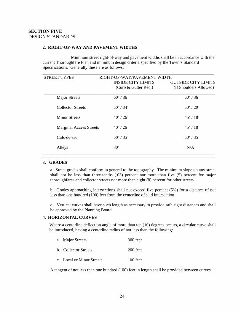
Minimum street right-of-way and pavement widths shall be in accordance with the current Thoroughfare Plan and minimum design criteria specified by the Town’s Standard Specifications. Generally these are as follows:
_______________________________________________________________________________ STREET TYPES RIGHT-OF-WAY/PAVEMENT WIDTH
INSIDE CITY LIMITS OUTSIDE CITY LIMITS (Curb & Gutter Req.) (If Shoulders Allowed)
_______________________________________________________________________________ Major Streets 60’ / 36’ 60’ / 36’ Collector Streets 50’ / 34’ 50’ / 20’ Minor Streets 40’ / 26’ 45’ / 18’ Marginal Access Streets 40’ / 26’ 45’ / 18’ Culs-de-sac 50’ / 35’ 50’ / 35’ Alleys 30’ N/A _______________________________________________________________________________ _______________________________________________________________________________ 3. GRADES
a. Street grades shall conform in general to the topography. The minimum slope on any street shall not be less than three-tenths (.03) percent nor more than five (5) percent for major thoroughfares and collector streets nor more than eight (8) percent for other streets. b. Grades approaching intersections shall not exceed five percent (5%) for a distance of not less than one hundred (100) feet from the centerline of said intersection. c. Vertical curves shall have such length as necessary to provide safe sight distances and shall be approved by the Planning Board.
4. HORIZONTAL CURVES
Where a centerline deflection angle of more than ten (10) degrees occurs, a circular curve shall be introduced, having a centerline radius of not less than the following: a. Major Streets 300 feet b. Collector Streets 200 feet c. Local or Minor Streets 100 feet
A tangent of not less than one hundred (100) feet in length shall be provided between curves.
25
SECTION FIVE DESIGN STANDARDS 5. INTERSECTIONS Street Intersections shall be laid out as follows:
a. Streets shall intersect as nearly as possible at right angles, and no street shall intersect at less than seventy-five (75) degrees.
b. Intersections with an arterial street shall be at least eight hundred (800) feet apart measured
from centerline to centerline, and intersections with an expressway shall be controlled and determined by the Planning Board.
c. Property lines at street intersections shall be curved with a minimum radius of fifteen (15)
feet and where the angle of street intersection is less than seventy-five (75) degrees, the Planning Board may require a greater radius. Where a street intersects a highway, the design standards of the State of North Carolina Highway Commission shall apply.
d. Street jogs with centerline offsets of less than one hundred twenty-five (125) feet shall be
avoided.
6. CUL-DE-SAC
A cul-de-sac shall not exceed five hundred (500) feet in length measured from the entrance to the center of the turn-around. A street designed to be permanently closed shall be provided at the closed end with a turn-around having a minimum right-of-way diameter of one hundred (100) feet and a minimum travel surface diameter of seventy (70) feet or a circular driveway twenty (20) feet wide around an island improved with suitable landscaping. Adequate sewer and water line right-of-way should be reserved to eliminate waterline dead ends and to provide sewerage outfalls.
7. ALLEYS
a. Alleys shall be discouraged, but may be allowed in commercial and industrial sections. The Planning Board may require alleys in these areas to provide for service access, such as off-street loading, unloading, and parking consistent with and adequate for the uses proposed.
b. The width of an alley to service commercial and industrial areas shall be not less than
thirty (3) feet. Dead end alleys, if allowed, shall be provided with adequate turn-around facilities at the dead end as determined by the Planning Board.
c. Alleys are not permitted in residential districts except when the Planning Board determines
special conditions warrant a secondary means of access. No alley shall front on a major street.
26
SECTION FIVE DESIGN STANDARDS 8. EASEMENTS Utility and other easements shall be provided as follows:
a. Where a subdivision is transversed by a water course, drainage way, channel, or stream, there shall be provided a storm easement or drainage right-of-way conforming substantially with the lines of such water course, and such further width or construction, or both, as will be adequate for the purpose, as determined by the Planning Board.
b. Unless a developer can specifically show that such are not needed to meet Town standards
for utilities or drainage, easements not less than ten (10) feet wide, centered on lot lines for both underground and aboveground facilities, for use by both public and private utilities shall be provided along each rear lot line. A five (5) foot easement along side lot lines, of individual lots may be required where necessary for use by public and private utilities.
9. PEDESTRIAN PATHWAYS
a. The Planning Board may require pedestrian easements for walkways, bicycle paths, etc., to be provided through the interior of blocks having a length greater than eight hundred (800) feet where such easements are needed to provide adequate pedestrian circulation, or access to schools, shopping centers, churches or transportation facilities. Pedestrian easements shall be at least four (4) feet wide and shall be laid out along property lines. Such pathways shall be part of the street right-of-way when associated with streets.
b. Lakes, ponds, creeks, and similar areas within the Town will be accepted for maintenance
only if such acceptance is recommended by the Planning Board and approved by the Board of Commissioners.
10. BLOCKS Blocks shall be laid out with special attention given to the type of use contemplated.
a. Block lengths shall not exceed eight hundred (800) feet without a variance, nor in any case be greater than fifteen hundred (1,500) feet; nor shall blocks be less than four hundred (400) feet in length. If variance is granted for a block design greater than eight hundred (800) feet, the Planning Board shall require pedestrian pathway to be located in a central position.
b. Blocks shall have a sufficient width to allow two (2) tiers of lots of minimum depth.
Blocks may consist of single tier lots where such are required to separate residential development from through vehicular traffic or nonresidential uses.
11. BUILDING SETBACK LINES
The minimum building setback or the distance between the street right-of-way line and the building line shall not be less than that prescribed in the Zoning Ordinance for the Town of Williamston for the appropriate zone or zones in which the subdivision exists.
27
SECTION FIVE DESIGN STANDARDS 12. LOTS a. Lot sizes, shapes, and locations shall be made with due regard to topographic conditions, contemplated use, and the surrounding area. Every lot shall front or abut a street for a distance of at least fifty (50) feet. b. Where public water and sewer facilities are available, every lot shall be required to utilize the municipal services and all lots shall contain not less than the area prescribed in the Zoning Ordinance of the Town of Williamston for the appropriate zone or zones in which the subdivision exists. c. Residential lots in areas of the extraterritorial jurisdiction where public sewer and water facilities are not available shall have a minimum size of at least twenty thousand (20,000) square feet in area, unless approved by the county Environmental Health Specialist. d. Corner lots for residential use shall have an extra width of ten (10) feet to permit adequate building setback from side streets. e. Double frontage and reverse frontage lots shall be avoided except where necessary to separate residential development from through traffic on nonresidential uses. f. Side lot lines shall be substantially at right angles or radial to street lines. g. Depth and width of properties laid out for commercial or industrial uses shall be adequate to provide for the off-street service and parking facilities required by the type of use and development contemplated. 13. PUBLIC UTILITIES Water and sewer utilities shall be provided in accordance with requirements of the N. C. Division of Environmental Management, the Division of Environmental Health, and Williamston Town Standard Specifications. 14. DRAINAGE Stormwater runoff shall be addressed in accordance with requirements of the N.C. Division of Environmental Management and with Town Standard Specifications.
28
SECTION SIX IMPROVEMENTS
Final plats for all subdivisions shall not be approved until all the required improvements listed in this section have been installed or the subdivider has guaranteed to the satisfaction of the Town Board of Commissioners that such improvements will be installed. All improvements will be made in conformity with the requirements and standards set forth in this ordinance and the Town of Williamston Standard Specifications. All improvements shall be inspected and approved by the Public Works Supervisor and the Town Administrator as conforming to the requirements of the Town. All improvement specifications of the Town of Williamston are on file in the Office of the Town Clerk. No municipal services or facilities will be extended or furnished by the Town of Williamston to any subdivision established hereafter either inside or outside the Corporate Limits until the subdivider has installed the required improvements listed in this section or has guaranteed to the satisfaction of the Board of Commissioners of the Town of Williamston that such improvements will be installed. A. GUARANTEES IN LIEU OF COMPLETED IMPROVEMENTS No final subdivision plat shall be approved by the Town Board of Commissioners or accepted for record by the Register of Deeds of Martin County until the required improvements have been constructed in a satisfactory manner and approved by the Town Administrator or, in lieu of such prior construction, the Town Board of Commissioners may accept a bond with surety and condition satisfactory to the town in an amount equal to the estimated cost of the installation. The Public Works Supervisor will be asked to estimate the cost of improvements. The Town may also accept in lieu of bond a certified check or cash deposit with the Town of Williamston equal to the estimated cost of the installation. With either of these guarantees, improvements may be made and utilities installed without cost to the Town or County in the event of default by the subdivider. A contract shall be entered into between the Town and the developer detailing the terms and methods of guarantees. The owner of the subdivision shall require the contractor constructing streets, curbs, gutter, sidewalks, drainage facilities, or water and sewer lines to give bond guaranteeing the work against defects. B. IMPROVEMENTS REQUIRED Permanent Survey Reference Markers Permanent survey reference markers shall be installed in all subdivisions in accordance with North Carolina General Statutes 39-32.1 through 39-32.4 and the following requirements:

29
SECTION SIX IMPROVEMENTS Permanent Concrete Monuments
Permanent concrete monuments four (4) inches in diameter or square, three (3) feet long, shall be placed at not less than two (2) corners of the subdivision, provided that additional monuments shall be placed where necessary so that no point within the subdivision lies more than five hundred (500) feet from a monument. Two (2) or more of the required monuments shall be designed as concrete corners. The top of each monument shall have an indented cross metal pin, or metal plats to identify properly the location of the point. All monuments shall be shown on the final plat.
Steel or Iron Markers
Steel or iron markers shall be set at all lot and property corners and at all other survey points not marked by monuments. Such markers shall be set at points of curve, points of tangency, reference points, and points of intersection. Survey markers shall be at least three-fourths (3/4) inches in diameter, and shall be sunk vertically into the ground until the top is approximately four (4) inches above the finished grade, except in sidewalks, streets, and other similar surfaces where the markers shall be flush with such surface.
Street Paving
All new streets shall be paved in accordance with design standards listed in Section Five, B. 2 and the Town’s Standard Specifications manual.
Street Grading
The subdivider of any subdivision designed to be used for residential, commercial, industrial, or other purposes shall clear and grade all streets according to prevailing specifications of the Town of Williamston. The Public Works Supervisor shall provide such criteria to a subdivider during the preliminary plat review process, or before at the subdivider’s request. Street grading may not be substituted for street paving improvements.
Street Name Markers (Signs)
Street name markers (signs) shall be provided at all street intersections and at any other point within the subdivision as deemed necessary by the Town. The placement and construction of such signs shall conform to specifications of the Town of Williamston and shall be installed by the Town. No name shall duplicate or be phonetically similar to any currently existing street.

30
SECTION SIX IMPROVEMENTS Water Supply
Every lot in every subdivision within the town limits of Williamston shall be supplied by the developer with water from the Town of Williamston. The water system shall be constructed by the developer in accordance with the water services policies of the Town of Williamston and under the supervision of the Town Public Works Supervisor. Where public water service is available, lots shall be required to utilize municipal service. All individual water supplies outside the town limits shall be located, constructed, and operated in accordance with standards and specifications of the North Carolina Division of Environmental Health. Minimum line size and design flow requirements shall be in accordance with Town Standard Specifications and the Division of Environmental Health.
Fire Hydrants
The subdivider shall install fire hydrants as recommended by the Fire Chief where a public water supply is available.
Sewage Disposal
Where a subdivision is within the town limits, the subdivider shall provide connection to the sewer system of the Town of Williamston in order to provide sewer service to every lot within the subdivision. Sewer connections shall be constructed under the supervision and approval of the Public Works Supervisor. Where public sewer service is available, lots shall be required to utilize municipal service. Where public sewer service is not available, proposed sites for individual sewage disposal systems outside the town limits shall be investigated by an environmental Health Specialist with the Martin County Environmental Health Section to determine whether or not such individual facilities are feasible. Approval of the County Environmental Health Specialist must be in writing. When individual sewage disposal systems are allowable, the minimum lot size shall be twenty thousand (20,000) square feet. If the need is demonstrated by the results of percolation tests and subsoil investigations, the minimum lot sizes may be increased to the needed size. Smaller lots may be considered if allowed by State law or regulations.
Surface Water Drainage
A plan to accommodate stormwater runoff shall be a required part of every major subdivision plat approved by the Board of Commissioners and shall be in accordance with all State regulations governing stormwater runoff and Town Standard Specifications. (1) No surface water shall empty into a sanitary sewer.

31
SECTION SIX IMPROVEMENTS
(2) Where, in the opinion of the Town Planning Board or Board of Commissioners, a public stormwater sewer is reasonably accessible, before a subdivision is approved and accepted, the subdivider shall connect with the public storm sewer system. He shall provide all grading and all structure necessary to carry the water to the public storm drainage system. Drainage and construction of drainage structures shall conform to town specifications and standards. (3) Where a public storm drainage system is not accessible, before a subdivision is approved and accepted by the Town of Williamston, the subdivider shall do all grading and provide all drainage structures necessary to properly carry the water to locations approved in the final plat. (4) Where drainage ditches exceed grades of four percent (4%), the ditches shall be improved in accordance with town standards. (5) For all major subdivisions, a professional evaluation of the proposed drainage plan shall be provided by the Developer, including a Statement of Impact describing the effects of the proposed drainage system on downstream drainage based on the ten-year storm flow. If the Statement of Impact finds adverse impacts on downstream flows, the developer must provide a plan to mitigate such adverse impacts.
Sidewalks
Sidewalks may be required along officially designated major thoroughfares and may be required along any minor or collector street where considerable pedestrian traffic is expected. Sidewalks shall be constructed in the street right-of-way and installed in accordance with specified town standards by the Town Board of Commissioners.
Street Trees
It is recommended that trees be planted along the streets in all subdivisions. The planting of trees is considered a service to be expected of the subdivider, as well as good business practice. Trees are a protection against excessive heat and glare and enhance the attractiveness and value of property. Trees shall be planted inside the property line where they are less subject to injury, decrease the change of motor accidents, and enjoy more favorable conditions for growth.
Electrical and Telephone Service
All electrical, telephone, and telegraph utility main and service connections shall be installed according to Town Standard Specifications and prevailing practices of companies providing such services.

32
SECTION SIX IMPROVEMENTS Street Lights
Street lights shall be required at intervals and within design standards in accordance with prevailing Town Standard Specifications as well as the standards of the power company.
Curb and Gutter
Curb and gutter shall be routinely installed by the subdivider for all new streets inside the City Limits, and for any other new streets as a condition placed by the Town, according to existing Town Standard Specifications.
Dumpster Pads
Concrete dumpster pads shall be repaired in all subdivisions except single family residential according to Town Standard Specifications.
33
APPENDIX A
CERTIFICIATIONS Forms for final certification: The following certificates shall be lettered or rubber stamped on the final plat in such a manner as to insure legible reproduction:
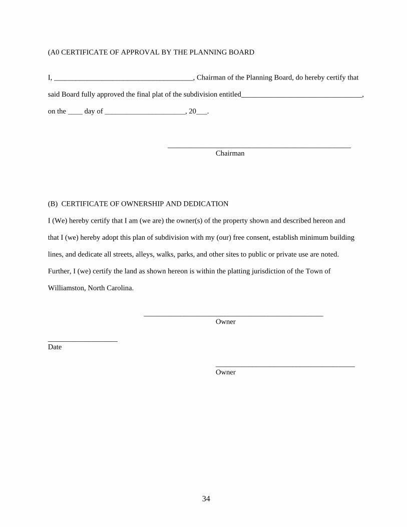
34
(A0 CERTIFICATE OF APPROVAL BY THE PLANNING BOARD I, ______________________________________, Chairman of the Planning Board, do hereby certify that said Board fully approved the final plat of the subdivision entitled_________________________________, on the ____ day of ______________________, 20___. __________________________________________________ Chairman (B) CERTIFICATE OF OWNERSHIP AND DEDICATION I (We) hereby certify that I am (we are) the owner(s) of the property shown and described hereon and that I (we) hereby adopt this plan of subdivision with my (our) free consent, establish minimum building lines, and dedicate all streets, alleys, walks, parks, and other sites to public or private use are noted. Further, I (we) certify the land as shown hereon is within the platting jurisdiction of the Town of Williamston, North Carolina. _________________________________________________ Owner ___________________ Date ______________________________________ Owner

35
(C) CERTIFICATION OF APPROVAL OF THE INSTALLATION AND CONSTRUCTION OF STREETS, UTILITIES, AND OTHER REQUIRED IMPROVEMENTS I do hereby certify (1) that streets, utilities and other required improvements have been installed in an acceptable manner and according to town specifications and standards in the subdivision entitled _________________________________________, or (2) that a guarantee of the installations of the required improvements in an amount or manner satisfactory to the Town of Williamston has been received. ________________ __________________________________________ Date Town Administrator (if improvements are not installed) ________________ __________________________________________ Date Public Works Supervisor (if improvements are installed) (D) CERTIFICATE OF ACCURACY I hereby certify that the plan shown and described hereon is a true and correct survey to the accuracy required by the Williamston Planning Board and that the monuments and markers have been placed in accordance with Williamston’s Subdivision Regulations. ___________________ _____________________________________________ Date Registered Engineer or Surveyor
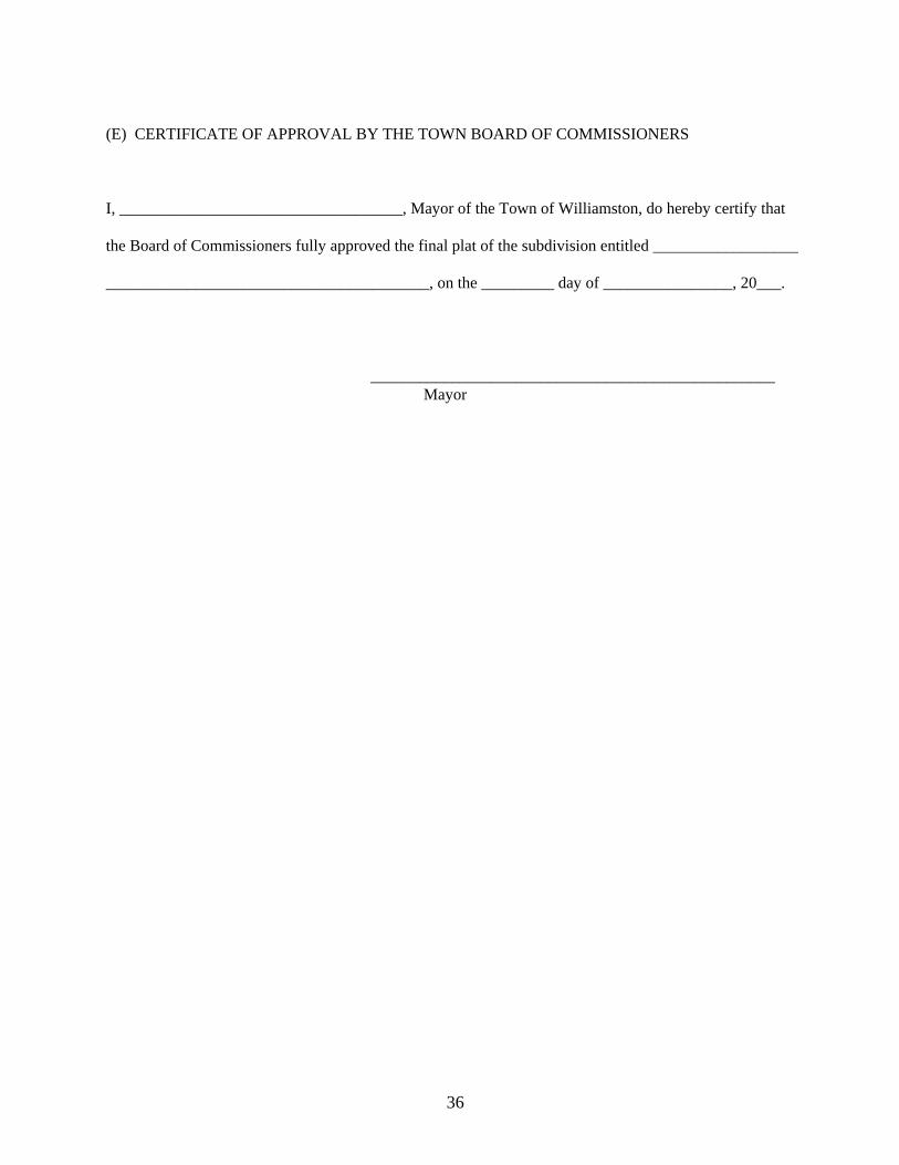
36
(E) CERTIFICATE OF APPROVAL BY THE TOWN BOARD OF COMMISSIONERS I, ___________________________________, Mayor of the Town of Williamston, do hereby certify that the Board of Commissioners fully approved the final plat of the subdivision entitled __________________ ________________________________________, on the _________ day of ________________, 20___. __________________________________________________ Mayor
37
APPENDIX B
SAMPLE PLATS The following plats are intended to be simple examples which show some of the plat requirements listed in this document. No example herein addresses all situations nor specifically satisfies all of the Town of Williamston’s requirements. Developers are encouraged to work closely with the administrator of this ordinance and with their own design professionals in order to fully comply with stated requirements.