STATUS OF THE EUMETSAT SATELLITE PROGRAMMES...STATUS OF THE EUMETSAT SATELLITE PROGRAMMES . TOWARDS...
39
STATUS OF THE EUMETSAT SATELLITE PROGRAMMES TOWARDS THE NEXT GENERATION METEOROLOGICAL SATELLITES Kenneth Holmlund EUMETSAT P. Schlüssel, R. Stuhlmann, L. Schüller, J. Schmetz, M. Cohen S. Rota, D. Klaes R. Munro, F. Montagner, C. Hanson, J. Grandell And many other contributors from EUMETSAT and its partners
Transcript of STATUS OF THE EUMETSAT SATELLITE PROGRAMMES...STATUS OF THE EUMETSAT SATELLITE PROGRAMMES . TOWARDS...

STATUS OF THE EUMETSAT SATELLITE PROGRAMMES
TOWARDS THE NEXT GENERATION METEOROLOGICAL SATELLITES
Kenneth Holmlund EUMETSAT
P. Schlüssel, R. Stuhlmann, L. Schüller, J. Schmetz, M. Cohen S. Rota, D. Klaes
R. Munro, F. Montagner, C. Hanson, J. Grandell And many other contributors
from EUMETSAT and its partners

2 AMS 2016 Session 2.4
EUMETSAT’S MISSION
The primary objective is to establish, maintain and exploit European operational meteorological satellite systems, taking into account as far as possible the recommendations of the WMO A further objective is to contribute to operational
climate monitoring and detection of global climatic changes Through fulfilling these objectives, contribute to
environmental monitoring, where interactions with the ocean and the atmosphere are involved

3 AMS 2016 Session 2.4
METOP -A and -B (LOW-EARTH, SUN – SYNCHRONOUS ORBIT) EUMETSAT POLAR SYSTEM/INITIAL JOINT POLAR SYSTEM
JASON-2 (LOW-EARTH, 63° INCL. NON SYNCHRONOUS ORBIT) OCEAN SURFACE TOPOGRAPHY MISSION
METEOSAT SECOND GENERATION -8.-9.-10, MSG-4 (-11) (GEOSTATIONARY ORBIT) TWO-SATELLITE SYSTEM: - METEOSAT-11: IN-ORBIT BACKUP - METEOSAT-10: FULL DISK IMAGERY MISSION AT 0° (15 MN) - METEOSAT-9: RAPID SCAN SERVICE OVER EUROPE AT 9.5°E (5 MN) - METEOSAT- 8: BACK UP AT 3.5°E
METEOSAT – 7 (1st GENERATION) (GEOSTATIONARY ORBIT) INDIAN OCEAN DATA COVERAGE MISSION AT 57°5 E (UNTIL END 2016)
Current EUMETSAT satellite fleet
4 AMS 2016 Session 2.4
MTG-I-1 : IMAGERY
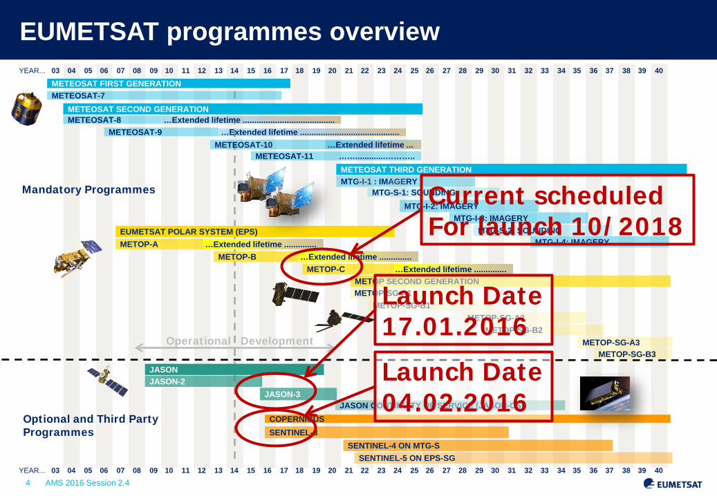
EUMETSAT programmes overview 03 04 05 06 07 08 09 10 11 12 13 14 15 16 17 18 19 20 21 22 23 24 25 26 27 28 29 30 31 32 33 34 35 36 37 38 39 40 YEAR...
METEOSAT FIRST GENERATION
METEOSAT SECOND GENERATION
METEOSAT THIRD GENERATION
EUMETSAT POLAR SYSTEM (EPS)
METEOSAT-7
METEOSAT-8 METEOSAT-9
METEOSAT-10 METEOSAT-11 …….............………..
MTG-S-1: SOUNDING MTG-I-2: IMAGERY
MTG-I-3: IMAGERY MTG-S-2: SOUNDING
MTG-I-4: IMAGERY METOP-A METOP-B
METOP-C METOP SECOND GENERATION METOP-SG-A1
JASON JASON-2
JASON-3 JASON CONTINUITY OF SERVICE (JASON-CS)
COPERNICUS SENTINEL-3
SENTINEL-4 ON MTG-S SENTINEL-5 ON EPS-SG
03 04 05 06 07 08 09 10 11 12 13 14 15 16 17 18 19 20 21 22 23 24 25 26 27 28 29 30 31 32 33 34 35 36 37 38 39 40
Mandatory Programmes
Optional and Third Party Programmes
YEAR...
METOP-SG-B1 METOP-SG-A2
METOP-SG-B2 METOP-SG-A3
METOP-SG-B3 Operational Development
…Extended lifetime .............. …Extended lifetime ..............
…Extended lifetime ..............
…Extended lifetime ...
…Extended lifetime ........................................ …Extended lifetime ...........................................
Current scheduled For launch 10/2018
Launch Date 17.01.2016
Launch Date 04.02.2016

5 AMS 2016 Session 2.4
METOP -A and -B (LOW-EARTH, SUN – SYNCHRONOUS ORBIT) EUMETSAT POLAR SYSTEM/INITIAL JOINT POLAR SYSTEM
Sentinel -3a (LOW-EARTH, SUN-SYNCHRONOUS ORBIT) Copernicus Global Marine and Land Environment Mission Operated by EUMETSAT
METEOSAT SECOND GENERATION -9, -10, -11 (GEOSTATIONARY ORBIT) TWO-SATELLITE SYSTEM: - METEOSAT-11: IN-ORBIT BACKUP - METEOSAT-10: FULL DISK IMAGERY MISSION AT 0° (15 MN) - METEOSAT-9: RAPID SCAN SERVICE OVER EUROPE AT 9.5°E (5 MN)
METEOSAT -8 (2nd GENERATION) (GEOSTATIONARY ORBIT) INDIAN OCEAN DATA COVERAGE MISSION AT 40° E (TBD June 2016)
Current EUMETSAT satellite fleet – Extrapolated end 2016
JASON-2, -3 (LOW-EARTH, 63° INCL. NON SYNCHRONOUS ORBIT) OCEAN SURFACE TOPOGRAPHY MISSION

6 AMS 2016 Session 2.4
1=VIS0.6
2=WV6.2
3=IR10.8
12=HRV
From MVIRI on MTP...
Slide: 6
Meteosat-7 is the last Located over - Indian Ocean - until end of 2016

7 AMS 2016 Session 2.4
1=VIS0.6 2=VIS0.8
3=NIR1.6
4=IR3.8 5=WV6.2 6=WV7.3 7=IR8.7
8=IR9.7 9=IR10.8 10=IR12.0 11=IR13.4
12=HRV
Slide: 7
From MVIRI on MTP to SEVIRI on MSG...

8 AMS 2016 Session 2.4
Multi-Mission Calibration and Monitoring System
Proposing development of Multi-Mission Calibration and Monitoring System (MuMiCS) To integrate monitoring systems for onboard, vicarious and inter-calibration For GEO and LEO sensors in different spectral bands Concept Engineering Change Proposal (ECP) will be submitted early 2015
SSCC
DCCs
Moon Example of the VIS06 band on MSG2/SEVIRI.Grey/black big dots: SSCC gains. Black smalldots: gains as available in Level 1.5 imageheaders (derived from SSCC). Blue dots: lunarcalibration. Magenta: DCC gains
Relative scale

ESTEC 23 January 2015
2011 July 25 11:30-12:30 Upper Layer (ice) COT scaled 0-11

ESTEC 23 January 2015
2011 July 25 11:30-12:30 Lower Layer (water) COT scaled 0-42

ESTEC 23 January 2015
2011 July 25 11:30-12:30 RGB 0.6, 0.8, 8-7-11
CTP: Ice blue, water green, COT represented by vertical bar 75/150 hPa COT-1
2-Layer Winds?

12 AMS 2016 Session 2.4
Atmospheric and Imagery Applications
Meteosat Second Generation – Development Highlights
• Use of the OCA heights to set AMV altitudes (operational readiness only after MSG-4 launch)
Traditional AMV product (CLA heights) AMV product (OCA heights)
Improved heights over Sahara jet
Identification of multi-layer situations

13 AMS 2016 Session 2.4
Volcanic Ash 2011 June to August

14 AMS 2016 Session 2.4
Scientific development for future / enhanced products (3) Coccolithophore blooms from the geostationary orbit ?

15 AMS 2016 Session 2.4
Met-8 super-rapid scans 2.5 min experiment
15 minutes Repeat Cycle
5 minutes Repeat Cycle
2.5 minutes Repeat Cycle

16 AMS 2016 Session 2.4
Meteosat Third Generation Continuation and enhancement of service from
geostationary orbit in 2020 – 2040
Twin satellite in-orbit configuration:
MTG A: optical imagery and lightning mission MTG B: sounding mission
Flies the Copernicus Sentinel-4 instrument
Two sets of successive satellites (4+2) for 20 years of operations
=> More today at 11:45!
17 AMS 2016 Session 2.4
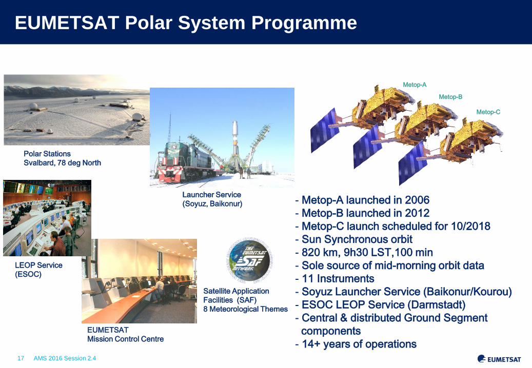
EUMETSAT Polar System Programme
Slide: 17 EUM/LEO/VWG/11/0587, EPS Day, 7th September 2011
- Metop-A launched in 2006 - Metop-B launched in 2012 - Metop-C launch scheduled for 10/2018 - Sun Synchronous orbit - 820 km, 9h30 LST,100 min - Sole source of mid-morning orbit data - 11 Instruments - Soyuz Launcher Service (Baikonur/Kourou) - ESOC LEOP Service (Darmstadt) - Central & distributed Ground Segment components - 14+ years of operations
Metop-A
Metop-B
Metop-C
Polar Stations Svalbard, 78 deg North
EUMETSAT Mission Control Centre
Launcher Service (Soyuz, Baikonur)
LEOP Service (ESOC)
Satellite Application Facilities (SAF) 8 Meteorological Themes

18 AMS 2016 Session 2.4
The EUMETSAT polar system as part of the initial joint polar system shared with the US
• Coordinated programmes • Exchange of instruments • Coordinated operations, data and services • Only Metop provides mid-morning service •And now China has committed to the early morning orbit
19 AMS 2016 Session 2.4
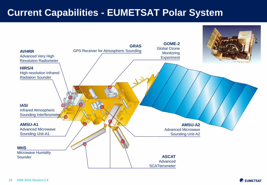
Current Capabilities - EUMETSAT Polar System
GOME-2 Global Ozone
Monitoring Experiment
GRAS GPS Receiver for Atmospheric Sounding AVHRR
Advanced Very High Resolution Radiometer
HIRS/4 High-resolution Infrared Radiation Sounder
IASI Infrared Atmospheric Sounding Interferometer
AMSU-A1 Advanced Microwave Sounding Unit-A1
MHS Microwave Humidity Sounder ASCAT
Advanced SCATterometer
AMSU-A2 Advanced Microwave
Sounding Unit-A2

20 AMS 2016 Session 2.4
Q1 PPF v5 Q1 OEM v6 Q1 First Guess v6
Southern oceans Intertrop. oceans 21-25/02/2014 21-25/02/2014
Results: T. August, M. Crapeau, T. Hultberg, X. Calbet
Atmospheric Profiling Hyperspectral Infrared L2 - IASI L2 v6 Temperature vs ECMWF ANA

21 AMS 2016 Session 2.4
Q3 PPF v5
Q3 First Guess v6
Southern oceans Intertrop. oceans 21-25/02/2014 21-25/02/2014
Atmospheric Profiling Hyperspectral Infrared L2 - IASI L2 v6 Temperature vs ECMWF ANA
Results: T. August, M. Crapeau, T. Hultberg, X. Calbet
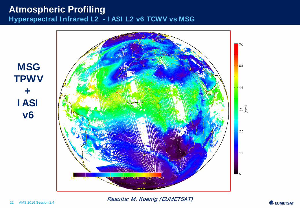
22 AMS 2016 Session 2.4 Results: M. Koenig (EUMETSAT)
MSG TPWV
+ IASI v6
Atmospheric Profiling Hyperspectral Infrared L2 - IASI L2 v6 TCWV vs MSG

23 AMS 2016 Session 2.4
Towards a IASI CO Profile product: a premiere
x1018 molec/cm2
CO Total column - Pollution over China, 12 January 2013
The IASI L2 processor v6 implements the FORLI-CO algorithm developed at ULB/LATMOS (O3M-SAF CDOP-2)
a priori (climatology)
retrieved CO profile
Boynard et al, 2014, GRL Credits: ULB/ LATMOS
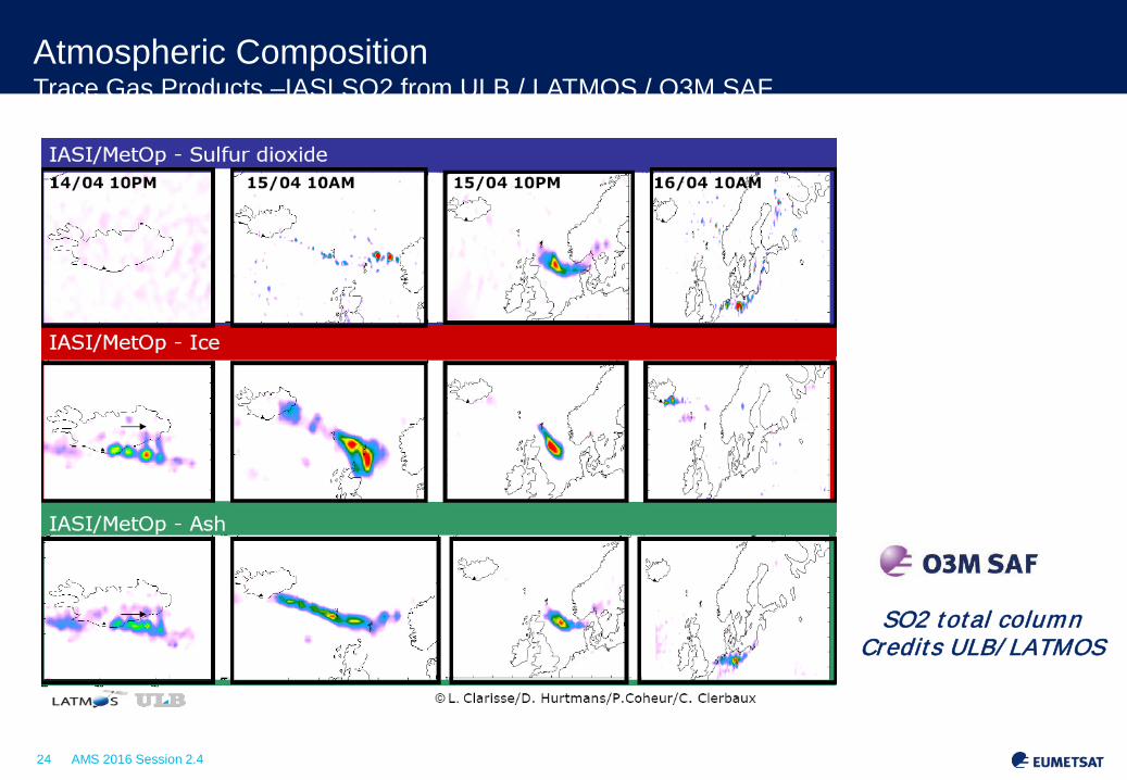
24 AMS 2016 Session 2.4 Slide: 24
SO2 total column Credits ULB/ LATMOS
Atmospheric Composition Trace Gas Products –IASI SO2 from ULB / LATMOS / O3M SAF
25 AMS 2016 Session 2.4
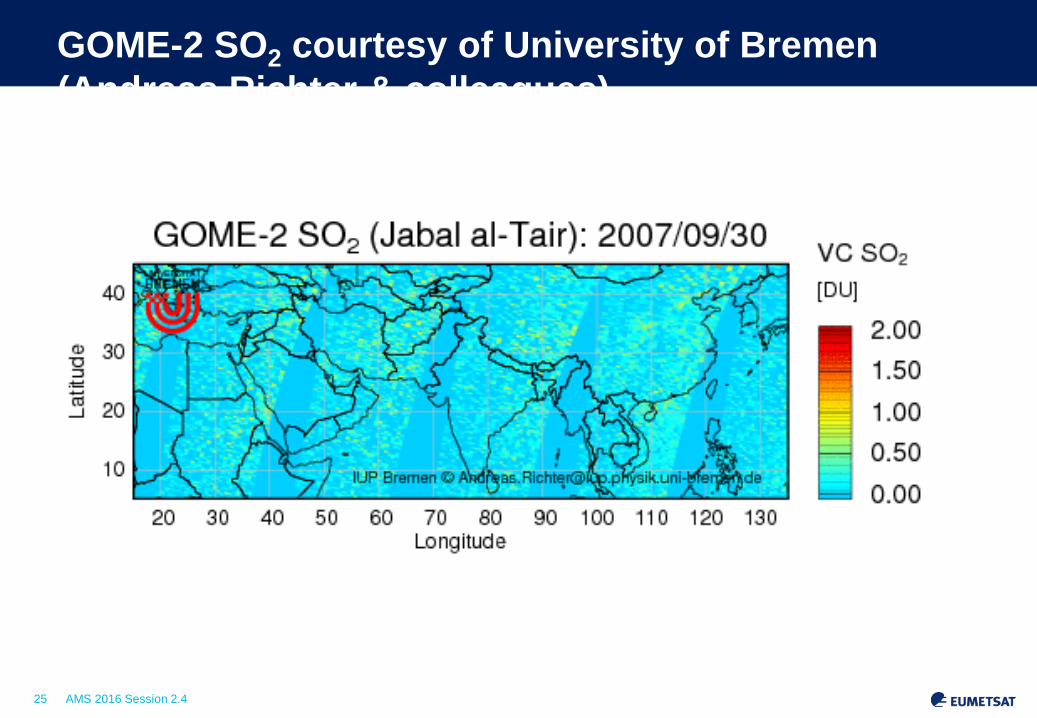
GOME-2 SO2 courtesy of University of Bremen (Andreas Richter & colleagues)

26 AMS 2016 Session 2.4
GO (operational)
GO (reprocessing)
WO (reprocessing)
Scientific development for future / enhanced products Wave optics for retrieval of GRAS profiles
Wave optics gives more data in the lowest 5 km... ...without increasing stdevs... negative biases of GO removed
Surface
Uncertainty in NWP reference data
Under investigation; can be improved

27 AMS 2016 Session 2.4
Aerosol: PMAp (GOME-2 + AVHRR) Metop A & B combined
AOD (PMAp – METOP A & B)
Ocean = Operational retrieval Land = test retrieval in development
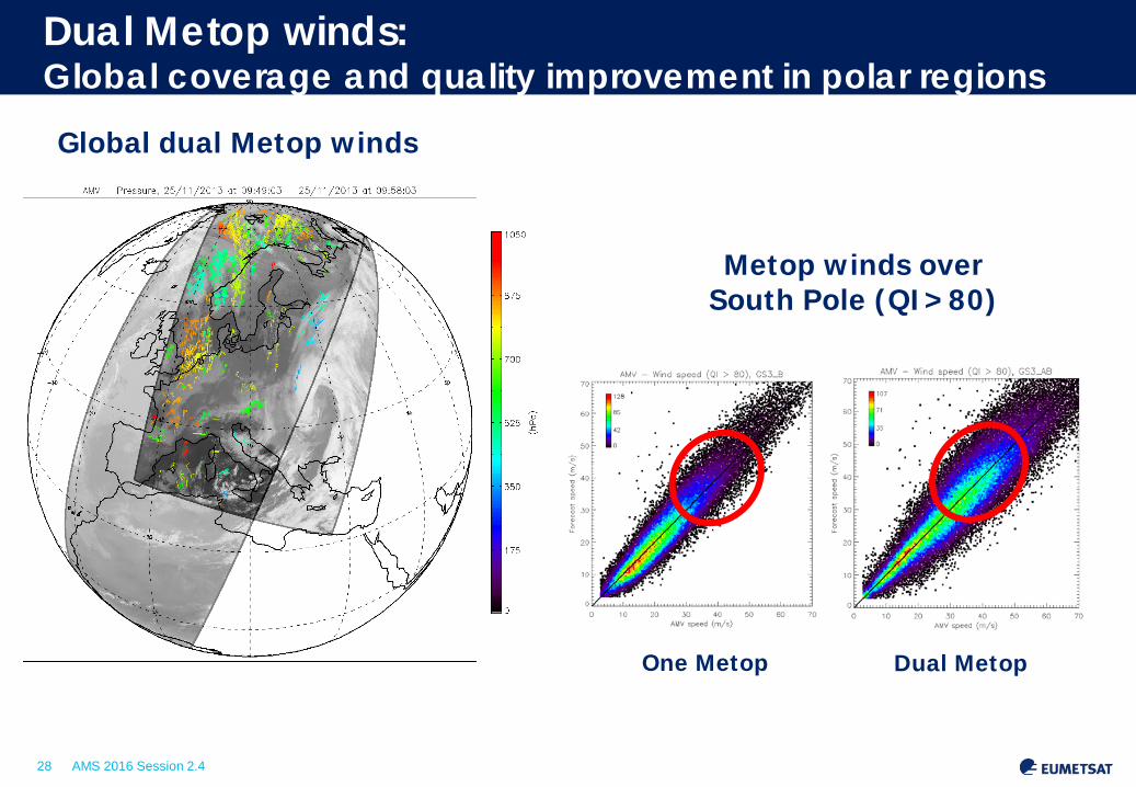
28 AMS 2016 Session 2.4
Dual Metop
Metop winds over South Pole (QI>80)
Dual Metop winds: Global coverage and quality improvement in polar regions
One Metop
Global dual Metop winds

29 AMS 2016 Session 2.4
Metop-B is in the same orbital plane as Metop-A
Metop-A
Metop-B
Metop-A
Morning Orbit Equator crossing time: 09:30 LST Orbit phasing: 48.93 min.
Metop-C in 2018

30 AMS 2016 Session 2.4
AVHRR winds
Single Metop polar, 17/09/2014, 1:31-1:52 Global AVHRR, 18/09/2014, 9:04-9:46
31 AMS 2016 Session 2.4
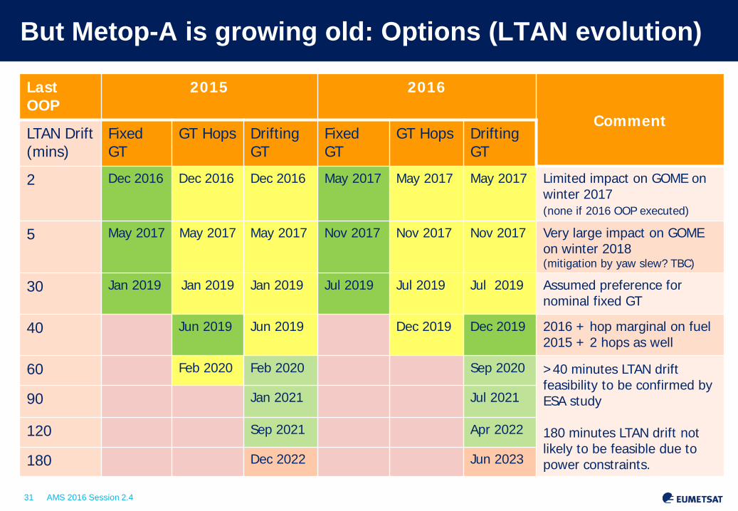
But Metop-A is growing old: Options (LTAN evolution)
Last OOP
2015 2016
Comment LTAN Drift (mins)
Fixed GT
GT Hops Drifting GT
Fixed GT
GT Hops Drifting GT
2 Dec 2016 Dec 2016 Dec 2016 May 2017 May 2017 May 2017 Limited impact on GOME on winter 2017 (none if 2016 OOP executed)
5 May 2017 May 2017 May 2017 Nov 2017 Nov 2017 Nov 2017 Very large impact on GOME on winter 2018 (mitigation by yaw slew? TBC)
30 Jan 2019 Jan 2019 Jan 2019 Jul 2019 Jul 2019 Jul 2019 Assumed preference for nominal fixed GT
40 Jun 2019 Jun 2019 Dec 2019 Dec 2019 2016 + hop marginal on fuel 2015 + 2 hops as well
60 Feb 2020 Feb 2020 Sep 2020 >40 minutes LTAN drift feasibility to be confirmed by ESA study 180 minutes LTAN drift not likely to be feasible due to power constraints.
90 Jan 2021 Jul 2021
120 Sep 2021 Apr 2022
180 Dec 2022 Jun 2023

32 AMS 2016 Session 2.4
EPS Second Generation
Continuation and enhancement of service from mid morning polar orbit in 2021 – 2040
Twin satellite in-orbit configuration:
Metop-SG A: optical imagery and sounding mission Flies the Copernicus Sentinel-5 instrument
Metop-SG B: microwave imaging mission
Two series of 3 successive satellites for 21 years of operations
European contribution to the Joint Polar System (JPS) shared with the US/NOAA => More today at 11:45!

33 AMS 2016 Session 2.4
MONITORING THE OCEAN IN SUPPORT OF COPERNICUS

34 AMS 2016 Session 2.4
Sentinel-3 Satellite and Payload First launch S-3a 4 February 2016
SLSTR: Sea and Land Surface
Temperature Radiometer
SRAL: Synthetic Aperture Radar Altimeter
OLCI: Ocean and Land Colour Instrument
MWR: Micro-Wave Radiometer
LRR: Laser Retro-Reflector
DORIS: Doppler Orbitography and Radiopositionning Integrated by Satellite
STM: Surface Topography Mission = SRAL + MWR

35 AMS 2016 Session 2.4
Sentinel-3 Marine product contents
Level 2 OLCI: • Normalised water surface reflectance • Algal pigment concentration for open and
for coastal waters • Total suspended matter concentration • Diffuse attenuation coefficient • Coloured dissolved matter absorption • Photosynthetically active radiation • Integrated water vapour • Aerosol optical depth • Aerosol Angström exponent
Level 2 SLTSR: • Sea surface temperature (L2P GHRSST standard)
Level 2 SRAL: • Sea/coastal zone surface height • Significant wave height • Wind speed • Backscatter coefficient σ0 • Sea ice height, freeboard • Total water, liquid water (from MWR)
Level 1B: SLTSR (radiance, BT at TOA) and OLCI (radiance at TOA) and SRAL(waveforms)
(ESA and EUMETSAT)

36 AMS 2016 Session 2.4
From Jason-2 to Jason-3 (launch 17 Jan 2016) Global sea level rise IPCC projections: Uncertainties
Observational evidence: Unique Climate Data Record
Global mean sea level during the altimetry era has risen at a nearly constant rate since 1993 (+- 3 mm/year) . Relatively consistent despite large regional interannual variations and accelerations in the melting of land ice.

37 AMS 2016 Session 2.4
Combining Sentinel-3 & Jason altimetry for operational oceanography and climate change monitoring
(Courtesy CNES/CLS/ESA)
Sentinel 3 Jason-3 and Jason-CS/Sentinel 6

38 AMS 2016 Session 2.4
Why has the western Pacific risen 3 times faster? Why has sea level dropped near the U.S. West Coast? How will regional sea level change in the future?
Mean sea level trends : regional differences 1993 - 2012

39 AMS 2016 Session 2.4
THANK YOU – QUESTIONS?