Parc national des...
58
Provisional Master Plan Parc national des Lacs-Guillaume-Delisle-et-à-l’Eau-Claire
Transcript of Parc national des...

P r o v i s i o n a l M a s t e r P l a n
Parc national desLacs-Guillaume-Delisle-et-à-l’Eau-Claire

P r o v i s i o n a l M a s t e r P l a n
Parc national desLacs-Guillaume-Delisle-et-à-l’Eau-Claire
This document was prepared by the:
Ministère du Développement durable, de l’Environnement et des ParcsDirection du patrimoine écologique et des parcsService des Parcs
Édifice Marie-Guyart675, boulevard René-Lévesque Est, 4e étageQuébec (Québec) G1R 5V7
Written by Stéphane Cossette
Cartography Jean Berthiaume André Lafrenière
Translation Tearza Snider
Layout André Lafrenière
Photographs David Boudreau Stéphane Cossette Robert Fréchette Jean Gagnon Jonathan Tessier
ACKNOWLEDGEMENT
This document was produced with the participation of many collaborators:
Kativik Regional Government Michael Barrett Josée Brunelle Robert Fréchette Sandy Gordon Laina Grey Peter Tookalook
Northern Village of Umiujaq Paulusie Cookie Jobie Crow Charlie Kumarluk Willie Kumarluk Alec Niviaxie Josuah Salla Davidee Sappa Robbie Tookalook
Northern Village of Kuujjuarapik Luckassie Inukpuk Sarah Quaraq Alec Tuckatuck
Northern Village of Whapmagoostui Georges Masty John Petagumskum père Sandy Petagumskum
Ministère du Développement durable, del’Environnement et des Parcs Serge Alain Jean Boisclair David Boudreau Raymonde Pomerleau
Makivik Corporation Mylène Larivière
Dépôt légalBibliothèque et Archives nationales du Québec, 2008ISBN 978-2-550-52709-1 (version imprimée) 978-2-550-52710-7 (PDF)
II
P r o v i s i o n a l M a s t e r P l a n

III
Parc na t i onal d e s Lacs -Gui l laume -Del i s l e - e t -à - l ’Eau -Cla i re
Table of contentsFOREWORD V
INTRODUCTION 1
THE PURPOSE OF CREATING THE PARK 1
HISTORY OF THE PARK’S CREATION 2
THE PROVISIONAL MASTER PLAN 5
HARVESTING RIGHTS OF THE BENEFICIAIRIES OF THE JAMES BAY AND NORTHERNQUÉBEC AGREEMENT 5
1 CURRENT SITUATION 7 1.1 TERRITORY UNDER STUDY 7
1.2 THE NATURAL REGIONS REPRESENTED 7
1.3 SITUATION OF THE REGION 11 1.3.1 LAND REGIME 11 1.3.2 USE OF THE TERRITORY 11
1.4 STATUS REPORT SUMMARY 12 1.4.1 CLIMATIC CONDITIONS 12 1.4.2 NATURAL HERITAGE 13 1.4.3 CULTURAL HERITAGE 15
1.5 HERITAGE STATUS 16
1.6 SERVICE PROFILE 16
2 SITUATIONAL ANALYSIS AND DIAGNOSIS 17 2.1 DEVELOPMENT POTENTIAL AND CONSTRAINTS 17 2.1.1 THE HUDSONIAN CUESTAS 18 2.1.2 THE RIVERS PLATEAU 21 2.1.3 THE GREAT LAKES PLATEAU 21
2.2 THE PROPOSED BOUNDARY 22
2.3 CONSERVATION THREATS 22
2.4 CHALLENGES 25

IV
P r o v i s i o n a l M a s t e r P l a n
3 CONSERVATION AND DEVELOPMENT CONCEPT 27 3.1 MANAGEMENT ORIENTATIONS 28 3.1.1 CONSERVATION 28 3.1.2 DEVELOPMENT OF THE NATURAL AND CULTURAL HERITAGE 30 3.1.3 PROTECTION OF THE RIGHTS OF BENEFICIARIES OF THE JBNQA 31 3.1.4 SAFETY 31 3.1.5 ADMINISTRATION AND REGIONAL DEVELOPMENT 31
3.2 ZONING 32 3.2.1 MAXIMUM PRESERVATION ZONES 32 3.2.2 PRESERVATION ZONES 32 3.2.3 AMBIENCE ZONES 35 3.2.4 SERVICE ZONES 35
3.3 PARK DEVELOPMENT 36 3.3.1 VISITOR CENTRE AND SERVICES 36 3.3.2 ACCESS TO THE PARK 36 3.3.3 ACTIVITIES 39 3.3.4 LODGING 42 3.3.5 PRIORITIES FOR BUILDING FACILITIES 44
CONCLUSION 45
BIBLIOGRAPHY 47
MAP LIST Map 1: The Network of Parks and Natural Regions 3 Map 2: Territory Under Study 9 Map 3: Landscape Units 19 Map 4: The Proposed Boundary 23 Map 5: Zoning 33 Map 6: Development Concept 37

V
Parc na t i onal d e s Lacs -Gui l laume -Del i s l e - e t -à - l ’Eau -Cla i re
Foreword
Since the enactment of the Parks Act in 1977, the government of Québec has created 22 national parks. These parks were created on the basis of criteria established by the World Conservation Union, as such, the forestry, mining and energy resources of a park are protected from com-mercial and industrial development. This means that hunting is also prohibited, as is the transi-tion of oil and gas pipelines and power transmission lines. The purpose of these measures is to protect territories and to safeguard their natural heritage for future generations.
The government of Québec’s commitment to creating the Parc national des Lacs-Guillaume-Delisle-et-à-l’Eau-Claire is in keeping with two major agreements it has signed onto. On April 9, 2002, the Makivik Corporation, Kativik Regional Government (KRG) and govern-ment of Québec signed a partnership agreement to broaden the economic and community development of the Nunavik territory (Sanarrutik). In an effort to bolster Nunavik’s tourist development, proposals were made to create the Parc national des Lacs-Guillaume-Delisle-et-à-l’Eau-Claire and Parc national des Monts-Torngat-et-de-la-Rivière-Koroc, located on the eastern shore of Ungava Bay, today known as the Parc national Kuururjuaq. This park was also created as part of the Québec Strategy on Protected Areas, the aim of which is to grant a legal protection status to 8% of Québec’s land.


Introduction
The shores of Hudson Bay hold a number of well-guarded se-crets. Sheltered from view by the most imposing system of cuestas in Québec, Lac Guillaume-Delisle is linked to Hudson Bay through a narrow corridor. Waters from several rivers spill into this lake, including Rivière à l’Eau Claire, which derives from the large water mass of Lac à l’Eau Claire. Lac à l’Eau Claire formed as the result of a meteorite impact and contains islands that feature flora unique to this location. Further east, an estimated 150 km from Hudson Bay, there is a unique wild-life feature that is exclusive in Québec: a population of seals that live in the freshwaters of Lacs des Loups Marins.
This enormous region has been occupied for thousands of years by two indigenous peoples: the Inuit and Cree. Both na-tions lived side by side and shared resources in the region to ensure their survival. The vast territory of the future Parc na-tional des Lacs-Guillaume-Delisle-et-à-l’Eau-Claire will make it Québec’s largest park.
THE PURPOSE OF CREATING THE PARKUnder its 1982 Parks Policy, the Ministère des Loisirs, de la Chasse et de la Pêche (MLCP) announced plans to develop a
network of parks, the focus of which would be to protect the representative or exceptional components of Québec’s natural heritage.
By creating the Parc national des Lacs-Guillaume-Delisle-et-à-l’Eau-Claire, the Ministère du Développement durable, de l’Environnement et des Parcs (MDDEP), plans to protect a territory that is a representative sampling of the natural re-gions of the Hudson Cuestas (B38) and Hudson Plateau (B37) (see Map 1). The park will also safeguard elements of the biodiversity of natural provinces H (Low Hills of the Grande Rivière) and I (Central Plateau of Northern Québec) as they are defined in the ecological reference framework (Li and Ducruc, 1999). Creating the park will also promote explora-tion and tourism in the region. The Inuit and Cree will also be closely involved in the park’s protection and development. An agreement will be concluded with the Kativik Regional Government, detailing responsibilities for park operations.
1
Photo : Stéphane Cossette, MDDEP
Parc na t i onal d e s Lacs -Gui l laume -Del i s l e - e t -à - l ’Eau -Cla i re

P r o v i s i o n a l M a s t e r P l a n
2
HISTORY OF THE PARK’S CREATIONThe idea to create a park in the Lac Guillaume-Delisle and Lac à l’Eau Claire region dates back to the early 1980s. Several years earlier in 1977, Québec introduced framework legisla-tion that would enable it to create parks based on criteria rec-ognized by the World Conservation Union. From this moment on and up until the beginning of the 1980s, the Ministère du Tourisme, de la Chasse et de la Pêche, which handled park matters at the time, revised the boundaries and vocations of existing parks. It developed a policy and tools that would fa-cilitate selection of sites to achieve its long-term objectives. It also designated among the other territories under its respon-sibility, those which it wished to incorporate into the system of Québec parks. The system was established on solid founda-tions thanks to this planning exercise.
In 1982, a working group (Pitsiataugik) from the MLCP draft-ed a list of several regions in northern Québec that could be granted the status of protected land. These regions were se-lected on the basis of their spectacular features, the diversity of their biological and physical components and their excep-tional and rare appeal. This planning exercise led to setting aside, among others, three regions that required protected status: lakes Guillaume-Delisle and à l’Eau Claire as a park, and Lacs des Loups Marins as an ecological reserve.
Over the period 1980-1986, the government created 14 parks south of the 49th parallel, in the part of Québec most heavily exposed to natural resource development and under the most environmental stress. It then declared a moratorium on new park creation in an effort to consolidate and develop estab-lished parks.
In 1989, the MLCP tabled a memorandum before the Comité ministériel permanent de l’aménagement, du développement régional et de l’environnement (COMPADRE) (permanent ministerial committee on land use, regional development and environment), which detailed sites of interest within the prov-ince that were located north of the 49th parallel, in order that the Ministère de l’Énergie et des Ressources list them as park projects in the public land use plan that was being prepared at the time. The goal was to protect lands that were representa-tive of natural regions in northern Québec or that offer par-ticular attractions, from development of forestry, mining and energy resources, until the government of Québec was ready to allocate legal park status to such lands.
In 1990, subsequent to an interministerial consultation, the COMPRADRE endorsed 18 projects submitted and requested that the Ministère de l’Énergie et des Ressources include these sites in the public land use plan.
In 1991, the region surrounding Lac à l’Eau Claire was part of the first group of lands set aside for park creation and there-fore were excluded from eligibility for mine staking, carto-graphic representation, mining research, and mining explor-ation under an ministerial order issued by the Ministère de l’Énergie et des Ressources (M.O. 91-192 [August 7, 1991], 1992 G.O.2., 4573, eff. 1991-07-11). In 1992, the region sur-rounding Lac Guillaume-Delisle was set aside according to the same conditions (M.O. 92-170 [July 15, 1992], 1992 G.O.2., 4596, eff. 1992-06-18). The same year, the MLCP unveiled its plan of action entitled “La nature en héritage.” An important step in the recent history of Québec parks, this plan made pro-visions to substantially increase the amount of land protected by park status. The plan’s contents detailed the intention of the Ministère to create the Parc national des Lacs-Guillaume-Delisle-et-à-l’Eau-Claire in Nunavik and its desire for the lo-cal community to participate in its development and manage-ment. The Ministère underscored its intention to first consult the communities concerned and to ensure compliance of its projects with regard to the James Bay and Northern Québec Agreement (JBNQA).
Meetings were then set up with the various committees aris-ing out of the JBNQA. In 1994, the Hunting, Fishing and Trap-ping Coordinating Committee subsequently passed a resolu-tion to support park projects in a nordic environment, insofar as the harvesting rights of beneficiaries were to be respected, as provided in Chapter 24 of the JBNQA and the Act respect-ing hunting and fishing rights in the James Bay and New Qué-bec territories (R.S.Q., c. D-13.1). Discussions were also held with the Kativik Environmental Advisory Committee (KEAC) and Kativik Environmental Quality Commission (KEQC).
In 1996, the KRG was mandated with development of the Nunavik territory and issued the Master Plan for Land Use in the Kativik Region, which listed all park projects in this part of Québec, including the Parc national des Lacs-Guillaume-Delisle-et-à-l’Eau-Claire. The plan received approval follow-ing a KRG Council resolution in 1998.
The KRG was very closely involved in preparing the park project. Following initial involvement in creation of the Parc


5
Parc na t i onal d e s Lacs -Gui l laume -Del i s l e - e t -à - l ’Eau -Cla i re
national des Pingualuit, the KRG was granted additional responsibilities to create parks in Nunavik, as set forth in an agreement with the Société de la faune et des parcs du Québec in June 2002. In accordance with the agreement, the Parc national des Lacs-Guillaume-Delisle-et-à-l’Eau-Claire would be created and the KRG would be responsible for carrying out work to build facilities and development, as well as managing park operations, activities and services.
To formalize discussions during the process leading up to creation of the Parc national des Lacs-Guillaume-Delisle-et-à-l’Eau-Claire, a working group was set up in 2002. This committee is comprised of representatives from the Ministère du Développement durable, de l’Environnement et des Parcs and several interest groups, including the KRG, the Northern Villages of Umiujaq and Kuujjuarapik, Landholding Corpora-tions, the Makivik Corporation and two representatives from the Cree nation of Whapmagoostui. The working group en-courages the participation of local and regional organizations to help advance the project. Inventory work conducted by the KRG and MDDEP parks service was carried out in cooper-ation with the local community during the summers of 2004 and 2005. The project that was tabled for public consultation therefore developed in close cooperation with the citizens of the three communities and was bolstered by their wealth of knowledge.
THE PROVISIONAL MASTER PLANThe process to produce the Provisional Master Plan is the standard course of action in land use development projects. To begin the process, a planning team collected scientific data on the natural, archeological and historical resources in the area under study. Accessibility, services, conservation, economic development and tourism objectives in the local community were also assessed to ensure that the proposed park would fit with the services that are available in the region. A description of the land use and tenure rounded out the data. This informa-tion was gathered in an accompanying document prepared by the KRG entitled “Status Report.”
The data analysis detailed in the Status Report separated the more fragile sectors from those with greater development po-tential. On the basis of this information, the optimal perimeter of the park could be established for the park to fulfill its role. Once all of the components had been examined, guidelines to preserve the natural and cultural heritage were drafted, along
with policies to be followed regarding the activities and servi-ces that will be offered.
This Provisional Master Plan, prepared by the Direction du patrimoine écologique et des parcs of MDDEP, reflects rec-ommendations made by representatives of the communities of Umiujaq, Kuujjuarapik and Whapmagoostui. An important role has also been given to the involvement of Inuit and Cree in creation of the development concept, not only through the participation of members of the working group, but through the participation of principal users of the territory. This will ensure that attention will be given to their concerns regarding the presence of park visitors and activities they will be allowed to carry out. Their knowledge of the territory is also essential to ensure that facilities are placed in safe locations.
The upcoming public hearing, scheduled in accordance with the Parks Act (R.S.Q., c. P 9), will be an opportunity for the public to voice opinions and comments to improve the Provisional Master Plan. Once the KEQC authorizes the project, it will be submitted to the government. Whereupon, an order will be issued to proceed with the park’s creation. The final version of the master plan will serve as the framework to ensure that the conservation initiatives park administrators introduce to preserve the park’s natural and cultural heritage remain an ongoing concern
HARVESTING RIGHTS OF THE BENEFICIAIRIES OF THE JAMES BAY AND NORTHERN QUÉBEC AGREEMENTSince the Parc national des Lacs-Guillaume-Delisle-et-à-l’Eau-Claire is located on territory governed by the Agreement, it is important to clarify that in compliance with Chapter 24 of the JBNQA and the Act respecting hunting and fishing rights in the James Bay and New Québec territories (R.S.Q., c. D-13.1), bene-ficiaries will retain harvesting rights within park boundaries. Visitors who are not beneficiaries of the JBNQA, however, are subject to the provisions of the Parks Act, which under section 7 a) prescribes that “Notwithstanding any provision of law, hunting or trapping of every kind is prohibited in the park.”


7
Parc na t i onal d e s Lacs -Gui l laume -Del i s l e - e t -à - l ’Eau -Cla i re
1.1 TERRITORY UNDER STUDYThe territory that is being examined for the Parc national des Lacs-Guillaume-Delisle-et-à-l’Eau-Claire project is located near the community of Umiujaq. The territory stretches from 55°30’ to 57°00’ north latitude and from 72°00’ to 77°00’ west longitude, and includes the watersheds of Lac Guillaume-Delisle and Rivière Nastapoka (see Map 2).
1.2THE NATURAL REGIONSREPRESENTEDThe Parc national des Lacs-Guillaume-Delisle-et-à-l’Eau-Claire project represents two natural regions: Hudson Cuestas (B38) and Hudson Plateau (B37). The territory under study also borders on the southern part of the natural region of the Ungava Plateau (B39).
The natural region of the Hudson Cuestas stretches along the shoreline of Hudson Bay from the Manitounuk passage near Kuujjuarapik-Whapmagoostui to the Nastapoka passage, ap-proximately halfway between Umiujaq and Inukjuak. The cuestas are asymmetrical hills that were shaped by the effects of erosion. The cuestas have a gradual slope (dip slope) that plunges towards the sea but on the other side, facing the land interior; they consist of spectacular escarpments (scarps). The stratigraphic layering of rock produces extraordinary colour patterns (pink, red, green, white and black) along slopes. After glaciers melted, the Tyrrell Sea submerged the territory under an estimated 280 m of water and when the sea retreated, it left a series of remarkable elevated markings of ancient sea lev-els. The region is particularly rich in plant species. Around the periphery of Lac Guillaume-Delisle, a forest of white spruce thrives in a protected maritime environment that is sheathed in dense fog during the summer months. The dip slopes of cuestas, however, are populated by distressed stands of sparse black spruce and larch. This situation is attributed to constant exposure to harsh winds blowing in off Hudson Bay.
11 Current situation
Photo : Jean Gagnon, MDDEP

P r o v i s i o n a l M a s t e r P l a n
8
The natural region of the Hudson Plateau, covering an esti-mated 170,000 km², represents a large portion of Québec. This highland is tilted slightly east to west and has an average elevation of 300 m. Large lakes, including Lac à l’Eau Claire and Lacs des Loups Marins, stretch across the plateau that is traversed by great rivers. A covering of thin layers of glacial deposits overlays the region’s gneissic and granitic substrate. In the western portion along the coastal fringe, the post-glacial marine transgression of the Tyrrell Sea left signs in the form of marine shale and sand deposits in the lower reaches of valleys. Over the plateau, changes in vegetation are gradual and ex-tend in latitude: the area south of Grande rivière de la Baleine is a boreal forest environment, but north of the river, regions gradually give way to broad expanses of forest tundra.


11
Parc na t i onal d e s Lacs -Gui l laume -Del i s l e - e t -à - l ’Eau -Cla i re
The territory is also used for other purposes, namely tourist activities, vacationing, mining exploration, scientific research and conservation of the natural heritage. All these uses of the territory are controlled by rights issued by the government of Québec.
Tourism ActivitiesThe territory under study includes eight outfitters camps, which do not hold exclusive rights. Three outfitters camps are located on the shores of Lac à l’Eau Claire, the other five out-fitters camps are located along Rivière Nastapoka. Some out-fitter activities are consistent with the activities and services allowed in Québec’s national parks. Therefore, the ecotourism and fishing activities that outfitters provide will be allowed to continue within the park. Sport hunting, however, will be pro-hibited.
Independent adventurers spend time in the territory from time to participate in whitewater adventures. Ecotourism compan-ies also provide guide services to explore Lac Guillaume-Delisle and Rivière à l’Eau Claire.
VacationingA lease for vacationing purposes has been issued by the Ministère des Ressources naturelles et de la Faune in a sec-tor located on the shore of Lac Rousselin, between Lac à l’Eau Claire and Lac D’Iberville, where a cabin has been built.
Mining ActivityMining activities including staking, exploration and mining, are prohibited over an estimated 70% of the territory under study. Mining activity is allowed in the Rivière Nastapoka sec-tor. In fact, mining exploration activities were being carried out as this document is being written. Active mineral titles cover an area of 319 km².
Scientific ResearchThe territory under study has hosted a number of scientific research projects led by the Centre d’études nordiques, which is a research centre consisting of researchers from Université Laval, Université du Québec à Rimouski and the Centre Eau-Terre-Environnement of the Institut national de la recherche scientifique. The Centre conducts research in the natural sci-ences field and studies changes that can occur as a result of weather, natural disturbances and human activity over an area and time, and how these changes affect physical environments
1.3SITUATION OF THE REGIONThe administrative region of Nord-du-Québec is divided into two separate subregions, James Bay and Nunavik. The line of the 55th parallel separates them, with Nunavik occupying the north-ern position. Nunavik, which covers an area of 500,164 km², has 14 Inuit communities and one Cree community scattered along the coastline, as well as one Naskapi community. The closest village to the territory under study is Umiujaq, located approximately 8 km from the northern tip of Lac Guillaume-Delisle.
1.3.1 LAND REGIMEThe region of Nunavik is subject to the application of the land regime defined in the JBNQA. Under the regime, the territory is divided into three land categories, which determine how land can be used, along with the terms and conditions and respon-sibilities for management.
Immediately adjacent to the territory under study, Category I lands are owned by the Anniturvik Landholding Corporation of Umiujaq and Sakkuq Landholding Corporation of Kuujjuarapik, except for what lays beneath the ground. The lands edge around the limits of the villages and include the zone of influence where traditional activities are intense. There are also Category II lands, which are lands belonging to the province, where the Inuit have exclusive hunting, fishing and trapping rights. The boundaries of these lands are defined according to the availability of resour-ces that the Inuit can access, guaranteeing their right to harvest. The remainder of the territory consists of Category III lands. These lands also belong to the province, where the Inuit and Cree can hunt, fish and trap but do not have exclusive rights (Beauchemin, 1992).
1.3.2 USE OF THE TERRITORYFour communities use the territory under study for trad-itional subsistence activities: Inukjuak, Umiujaq, Kuujjuarapik and Whapmagoostui. The Inuit of Kuujjuarapik, Inukjuak and Umiujaq live mainly in the coastal and Lac Guillaume-Delisle sector. The Cree of Whapmagoostui are active primarily in the Lac à l’Eau Claire and Lacs des Loups Marins area. The Cree have traplines1 in the territory under study.
1 Cree trapline: any location where, by tradition or under the super-Cree trapline: any location where, by tradition or under the super-vision of a Cree tallyman, activities related to the exercising of the right to harvest are carried out (R.S.Q., c. D 13.1).

P r o v i s i o n a l M a s t e r P l a n
12
1.4 STATUS REPORT SUMMARYThis section is a summary of the document entitled “Parc national des Lacs-Guillaume-Delisle-et-à-l’Eau-Claire Project: Status Report” prepared by the KRG. The reader may consult this document if more detailed information is required.
1.4.1 CLIMATIC CONDITIONSDue to the size of the territory under study for the Parc national des Lacs-Guillaume-Delisle-et-à-l’Eau-Claire project and the diversity of the environments within the territory, there are variations in climate between zones near Hudson Bay, the land interior and the region near Lac à l’Eau Claire. Regardless of the location within the territory, the wind chill factor is felt year-round. This is an important factor visitors must consider when preparing for a stay in the park.
The variation in regional weather conditions follows a gradi-ent that drops as you travel south to north and west to east. Throughout the territory, variations in weather conditions manifest themselves in the landscape by a more favourable cli-mate in valleys, where vegetation is uniform and more varied, compared to barren hills with no trees or where tucking bush (krummholz) take root. The presence of Hudson Bay cools the weather in spring and summer, but warms it slightly in fall and winter. The frost-free season lasts approximately 70 days in the Lac Guillaume-Delisle sector, and an estimated 50 days in the Lac à l’Eau Claire sector.
The high cuestas towering above Lac Guillaume-Delisle pro-vide a natural protection against exposure to cold winds com-ing in off Hudson Bay and improve local weather conditions.
Summer is short and weather is unstable due to a recurrent arctic front above the coast. The average daily temperature is approximately 10°C in July and August, with a maximum high of 30°C and minimum low of 5°C. Due to the proxim-ity of Hudson Bay, the Lac Guillaume-Delisle sector receives more precipitation and experiences more fog, except in win-ter, when water is frozen. June and November are the months with the most precipitation (74%). Fog is a frequent occur-rence along the Hudson Bay coastline during summer and can sometimes disrupt air travel.
and northern ecosystems. The Centre d’études nordiques has a research station in Kuujjuarapik-Whapmagoostui, an out-post facility in Radisson, and has access to three check stations in the field, including one at Lac à l’Eau Claire. The KRG has signed a lease with the Centre that allows it to use KRG build-ings for research projects. The Centre d’études nordiques also operates a network of 80 climatological and geocryology sta-tions that have been set up throughout the region from the boreal forest to the High Arctic, but are concentrated mainly in Québec’s arctic. Four of these stations are found within the territory under study.
Conservation of the HeritageThe Committee on the Status of Endangered Wildlife in Canada has deemed the beluga population in eastern Hudson Bay to be endangered and the government of Québec has added beluga to the list of species likely to be designated threatened or vulnerable. This species congregates at the mouth of Petite rivière de la Baleine and Rivière Nastapoka. To help protect beluga, Fisheries and Oceans Canada has created sanctuaries at these locations. They are areas where hunting is prohibited; other activities that do not interfere with beluga are allowed.
Hydroelectric PotentialWith the signing of the Partnership Agreement on Economic and Community Development in Nunavik, Québec made a commitment to assess the hydroelectric potential north of the 55th parallel. On this matter, six rivers with enormous poten-tial have been targeted, including Rivière Nastapoka, which flows through the territory under study and originates at Lacs des Loups Marins.
Due to their relative proximity, Hydro-Québec is planning de-velopment projects to generate hydroelectric power from the Grande rivière de la Baleine and Rivière Nastapoka simultan-eously (to save on costs to build roads and power transmission lines). It is important to note that development of the complex at Grande rivière de la Baleine continues to remain a poten-tial Hydro-Québec project. In 2007, Hydro-Québec officially abandoned development of the Nottaway-Broadback-Rupert complex, but did not withdraw the provisions of the James Bay and Northern Québec Agreement that apply to Grande rivière de la Baleine.

13
Parc na t i onal d e s Lacs -Gui l laume -Del i s l e - e t -à - l ’Eau -Cla i re
Although the first frosts occur in September, continuous win-ter freezing temperatures set in between mid-October and mid-November. Winter is the sunniest season when atmos-pheric conditions are stable. Ice cover on Hudson Bay im-proves atmospheric conditions, but interferes with the regu-lating effect the sea has on the weather. Air masses from the west bring high-pressure cells that are accompanied with cold, dry and windy weather. January and February are the cold-est months, with an average daily temperature of - 24°C and extreme lows of - 50°C, not including the wind chill factor. The presence of pack ice on Hudson Bay reduces evaporation and hence precipitation. Between December and March, an estimated 75 cm of snow falls in Inukjuak and 113 cm in Kuuj-juarapik. By comparison, 263 cm falls in Québec City over the same period. Due to the prevalence and high speed of winds, snow sweeps across the region. Average snow cover during March is approximately 40 cm in Kuujjuarapik.
1.4.2 NATURAL HERITAGEThe natural heritage of the Parc national des Lacs-Guillaume-Delisle-et-à-l’Eau-Claire has a variety of components that are representative of the natural regions of the Hudson Cuestas and Hudson Plateau.
The Landscape and FormationThe territory under study is part of the Canadian Shield. On the whole, the plateau shows little sign of glacial wear compared to other regions of the Canadian Shield, such as the Torngat Mountains or the coast of the Hudson Strait, where deep fjords and valleys dissect ancient peneplains. Despite some similarity with landscapes of the Hudson Plateau, the land is remarkably different in the Lacs des Loups Marins sector, Lac à l’Eau Claire sector and Lac Guillaume-Delisle sector.
The topography of the ridge between Umiujaq and the portion of the territory under study located south of Petite rivière de la Baleine falls within the definition of cuestas, which are strata of rock gently sloping in one direction, consisting of consoli-dated sediments that are susceptible to erosion and covered by an outcrop of resistant beds. The cuestas were formed by ero-sion along lines of loose material that has exposed an irregular topography. This is the largest system of cuestas in Québec. Along the shores of Lac Guillaume-Delisle, ridges rise to an elevation of 420 m and on either side of the mouth of Petite rivière de la Baleine, elevation is 350 to 400 m.
Immediately to the east of the escarpment that fringes Hudson Bay, part of the Earth’s crust has dropped to form what is known as a graben. The depression that was formed has been filled in part by the waters of Lac Guillaume-Delisle. Most of the land around the lake’s edge is covered by a thick layer of unconsolidated deposits. The graben and Eau Claire Plateau converge where faults run along the sub-stratum. The drop of the sub-stratum has caused boulders to rise up due to isostatic compensation around the graben, creating horsts. The escarpment that has resulted is striking and a focal point of the landscape.
The Eau Claire Plateau contains the Lac à l’Eau Claire sec-tor and the entire area between the river valleys of Rivière Nastapoka and Petite rivière de la Baleine. The topography of the plateau varies little. The average difference in eleva-tion is 50 to 100 m between hilltops, inter-stream areas and low areas. Valleys in the plateau are narrow and shallow. The Lac à l’Eau Claire sector features a landscape covered by a lake, surrounded by small isolated hills that are set off by the surrounding plateau. An estimated 287 million years ago, a double meteorite impact struck the Earth’s crust and cre-ated two side-by-side circular depressions. Lac à l’Eau Claire is the second largest natural lake in Québec, covering an area of 1,226 km2.
The Loups Marins Plateau occupies the eastern and northern portions of the territory and ends approximately at the line that separates the drainage basin of the Nastapoka and à l’Eau Claire rivers. The physical geography of the Loups Marins pla-teau differs from the rest of the territory under study due to the large number of lakes scattered over an area in excess of 100 km2. Another distinguishing feature of this sector is the coverage of glacial deposits that are intersected by long eskers and give a smooth appearance to the overall landscape.Photo : Jean Gagnon, MDDEP

P r o v i s i o n a l M a s t e r P l a n
14
VegetationDifferent kinds of environment are present in the territory under study, but lichen heaths, exposed soil and scrubland in lowland areas dominates (38%). In this type of environment, trees account for less than 10% of the area. Black spruce-li-chen forests and black spruce-moss stands cover respectively 14.6% and 9.5% of the territory under study.
Botanical exploration of the territory under study began in the late XIXth century. Since the arrival of the Centre d’études nordiques, focus has been on the regions of lakes Guillaume-Delisle and Eau Claire and several thousands of specimens have been collected.
Collections and inventories conducted by Dignard (2007) provide a relatively accurate profile of vascular plant species within the territory under study. The annotated listing in-cludes 504 taxa. Overall, two-thirds of the vascular species present in the territory are classified as boreal. Along the same latitude, however, the distributions of boreal and arctic spe-cies differ according to sector. There is a higher proportion of boreal characteristics in the Lac à l’Eau Claire sector. Since the Lac Guillaume-Delisle sector experiences harsher weather conditions and more significant thermal shifts due to the prox-imity of Hudson Bay, arctic species make up most of the island and coastal plant flora. Further inland, flora consists mainly of boreal species. Due to the weather, topographical features and abundance of arctic taxa present, the cuestas and some ex-posed islands on Lac Guillaume-Delisle and the central islands of Lac à l’Eau Claire can be considered arctic enclaves.
The transitional location of the territory under study, in the
heart of the zone where the boreal region makes the shift to the subarctic, explains the large number of plant species grow-ing at the limit of their Québec-Labrador distribution range within the territory. In all, 39 species are growing at their northern limit, seven at their southern limit, seven at their land interior limit to the east and one at the western limit of its distribution range in North America.
Throughout the territory under study and based primarily on the frequency of harvests, there are 51 species of rare vascular taxa present in the region. Of this number, 35 are present in the Lac Guillaume-Delisle sector, six in the Rivière à l’Eau Claire sector and 16 in the Lac à l’Eau Claire sector. The higher proportion of rare species in the Lac Guillaume-Delisle sector can be attributed mainly to the presence of basic sedimentary rock, a larger number and variety of habitats, more contrast-ing weather conditions, the lake’s brackish waters and the salt water of Hudson Bay.
Ten species of vascular taxa in the Lac Guillaume-Delisle sec-tor are likely to be designated threatened or vulnerable in Québec.
WildlifeThe vast area of the territory under study and the diversity of habitats support a wide variety of wildlife species. According to the distribution maps consulted, the territory is home to 38 species of mammals, 131 bird species and 42 species of fish. The presence of two species of amphibians has been confirmed and four others are potentially present, along with one species of reptile.
The population of beluga in eastern Hudson Bay regularly visits the territory under study. Rivière Nastapoka and Petite rivière de la Baleine are two major estuary zones where large numbers of beluga commune between mid-July and late August, during the summer moulting season. A smaller number of beluga also venture into Lac Guillaume-Delisle and converge in Kilualuk Bay.
The portion of the territory under study that is exposed to the sea contains three species of seals, one of which lives 150 km inland. This is the population of harbour seals in the Lacs des Loups Marins region, which is estimated to be fewer than 500 individuals. The population is concentrated mainly in Lacs des Loups Marins, Petit lac des Loups Marins and Lac D’Iberville.
Photo : Jean Gagnon, MDDEP

15
Parc na t i onal d e s Lacs -Gui l laume -Del i s l e - e t -à - l ’Eau -Cla i re
1.4.3 CULTURAL HERITAGEThe Cree and Inuit have lived in the territory under study for thousands of years. The amount of information available about both groups, however, is unequal. Although the sequences of Inuit occupation are relatively well documented, less information exists about the indigenous occupation sequences in Québec’s subarctic region. In the case of both groups, the earliest occupation sites date back to 4000 BC. A number of Native and Inuit archeological sites dating back to different periods have been documented within the territory under study.
Although both groups occupy the territory under study, the first explorers to come to the sector indicated that the bound-ary lakes Guillaume-Delisle, à l’Eau Claire and Petit lac des Loups Marins form was the border that separated these two nations. Due to the contrasting lifestyles of the Cree and Inuit, there was little contact between them. The Inuit lived along the coastline to hunt marine mammals. The Cree lived inland where there was greater forest cover.
In 1670, the arrival of the Hudson Bay Company in North America marked a new era where major changes occurred among the Native people of James Bay and Hudson Bay. Due to the fur trade, the economy became focused on trapping, and land use patterns changed. Trading posts became new hubs of activity. The first trading posts were established mainly in the James Bay region. For most of the XVIIIth century, the trad-ing post located on Rivière Eastmain was the only permanent settlement on the east coast of James Bay and Hudson Bay.
The territory contains species of land mammals typical of the region, including caribou, moose, black bear and a variety of small mammals. The territory under study is also ideal habitat for the wolverine, a threatened species in Québec, and the Canadian lynx.
Of the 131 bird species that potentially inhabit the territory under study, the presence of 51 species has been confirmed, some of which warrant special attention. The territory lies within the migratory route of the Canada goose and snow goose, which use the area as flock grounds. The harlequin duck, a species likely to be designated threatened or vulnerable in Québec, has been observed in the past, particularly in the area of the Northern Village of Umiujaq, near the Goulet, along the tributaries of Lac Guillaume-Delisle, including the Nord, à l’Eau Claire and De Troyes rivers. The presence of Barrow’s goldeneye (a species likely to be designated threatened or vulnerable in Québec) has also been confirmed in Lac Guillaume-Delisle and in the downstream portion of the Petite rivière de la Baleine watershed, but no nesting site has been found. The presence of the golden eagle and bald eagle, two species designated vulnerable in Québec, has been confirmed. The golden eagle nests between the Grande rivière de la Baleine and Rivière Nastapoka. The best nesting sites for this species are along the cliffs near Petite rivière de la Baleine. The bald eagle nests in the tops of mature trees near a body of water.
Lac Guillaume-Delisle teams with marine and freshwater species of ichtyofauna. Artic char and brook trout compete for habitat in the lake. Brook trout, however, dominate all of the lake’s tributaries, except one small tributary on the west side of the lake. An item of interest is the fact that Rivière Nastapoka has a population of landlocked salmon. Although the estuary portion of the river contains brackish water, this species of salmon is considered to be landlocked because of its features and because it behaves like freshwater salmon. This is the only population of salmon on the east coast of Hudson Bay.
It is also important to acknowledge the population of amphib-ians and reptiles in the territory under study. The presence of the American toad and wood frog has been confirmed in the Lac Guillaume-Delisle sector. Four other amphibians could also inhabit the territory, including the blue-spotted salaman-der, and one reptile, the common garter snake. Photo : David Boudreau, MDDEP

P r o v i s i o n a l M a s t e r P l a n
16
Meetings with the Inuit and Cree during the planning phase of the park, revealed that there are no sacred locations in the territory under study. The Inuit of Umiujaq did, however, list some sites of cultural importance, mainly because traditional subsistence activities are carried out in these areas, particularly in Kilualuk Bay and Lac Pamiallugusiup in the Lac Guillaume-Delisle sector. The Cree of Whapmagoostui who live in the ter-ritory also identified two sites, one at Lac Guillaume-Delisle, the other at Lac à l’Eau Claire, where, in the past, certain indi-viduals sensed the presence of something. The individuals who provided this information indicated that these sites require no particular protection or classification. They expressed only the wish that any visitors who have the same type of experience at these sites disclose this information to park authorities.
1.5HERITAGE STATUS
Most of the natural heritage of the territory under study for the Parc national des Lacs-Guillaume-Delisle-et-à-l’Eau-Claire project is pristine. In some locations, however, there are signs of past occupation, particularly mining exploration. A number of oil drums have been spotted along Rivière à l’Eau Claire and remnants of buildings are still present on the Hudson Bay coast near the mouth of Petite rivière de la Baleine. Intensive beluga hunting between 1854 and 1868 caused a sharp decline of the beluga population in eastern Hudson Bay. Over this period, 8,294 beluga were slaughtered (Reeves and Mitchell, 1987). Today, the beluga population is an estimated 3,100 individuals.
1.6SERVICE PROFILE
Other than the presence of outfitting operations, there is no other service activity within the territory.
To encourage development of the territory, the Hudson Bay Company decided to set up its first northern-most trading post, located on Cairn Island in Lac Guillaume-Delisle. It also chose to mine a lead-bearing deposit on the shore of Petite rivière de la Baleine, near the mouth of the river. Business, however, was poor. Mining the lead deposit yielded little return and the fur trade failed to meet expectations since Natives in the region hunted mainly caribou and trapped little for fur. Trade with the Inuit also never materialized. In 1756, activities were transferred to Petite rivière de la Baleine, but were no more successful. In 1759, the Hudson Bay Company made the decision to shut down its trading post at Petite rivière de la Baleine.
It was not until the end of the XVIIIth century that activities began to take off in the sector, due mainly to hunting for beluga at the mouth of the Petite rivière de la Baleine. No permanent settlement was built however. Because beluga hunting de-pended on weather conditions, fortunes were not particularly good, which lead to the shutdown of this activity in 1821.
In the early 1840s, the Hudson Bay Company made contact with the Inuit for the first time and trading was prolific. Trade was initially carried out in Fort George (Chisasibi), but the Hudson Bay Company again decided to open a trading post in Petite rivière de la Baleine where trade with the Inuit would become concentrated. The hunt for beluga began to make a resurgence and was more successful. Compared to a total 423 beluga in 1854, the number hunted was well over 1,500 in 1860. Intensive harvesting caused stocks to decline quickly and in 1879 the activity came to a halt, but the trading post remained open for another twenty years.
In 1921, the Hudson Bay Company decided to reopen a trad-ing post at Lac Guillaume-Delisle near the former settlement on Cairn Island. One year later, the Revillon Frères company set up for business next door. Due to economic hardship dur-ing this period, the Hudson Bay Company bought out the Re-villon Frères trading post in 1926 and continued to operate until 1942, before moving facilities to the south shore of Lac Guillaume-Delisle near the business of an independent trader, George Papp, who had arrived in the region in 1938. Between 1940 and 1950, both trading posts were in operation, but the Hudson Bay Company purchased George Papp’s business in 1954 and transferred all of the buildings to the Papp site, where operations continued only briefly. The Company closed down operations on Lac Guillaume-Delisle in 1956.

17
Parc na t i onal d e s Lacs -Gui l laume -Del i s l e - e t -à - l ’Eau -Cla i re
A review of literature and ground surveys revealed compon-ents of the natural and cultural heritage that are representative of the natural regions that require protection, but also the rare or fragile components that warrant particular attention. The analysis revealed the following information.
2.1 DEVELOPMENT POTENTIAL AND CONSTRAINTSThe territory under study for the Parc national des Lacs-Guillaume-Delisle-et-à-l’Eau-Claire project contains a num-ber of components that are remarkable due to their size, con-dition, degree of representativeness or exceptional character
22 Situational analysis and diagnosis
within the natural region. These important characteristics have to do mainly with the physiographic geology, hydrography, vegetation, wildlife or archeology of the territory. The scenic aspect and panoramic appeal of certain sites has also been con-sidered. The territory does, however, contain some obstacles that must be considered when determining the boundary of the park and planning its development.
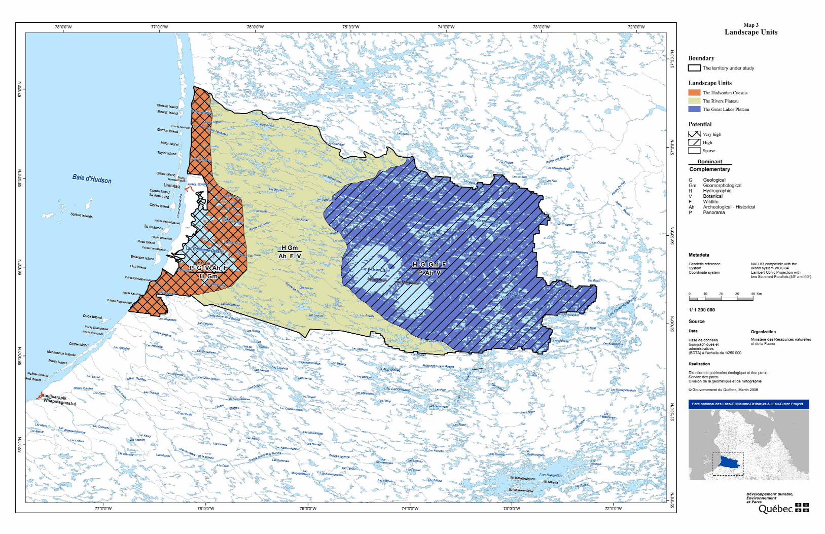
Based on a study of these factors, the territory under study can be divided into three separate landscape units: the Hudsonian Cuestas, the Rivers Plateau and the Great Lakes Plateau (see Map 3). Each unit is unique in this vast region for the excep-tional characteristics it features.
Photo : Stéphane Cossette, MDDEP

P r o v i s i o n a l M a s t e r P l a n
18
2.1.1 THE HUDSONIAN CUESTASThe Hudsonian Cuestas occupy the extreme western part of the territory under study. This is the most spectacular vista point available to visitors. The prominence of the cliffs that shape the face of cuestas is striking, reminiscent of the landscapes of canyons in the U.S. southwest. The distinctive topography of the cuestas offers a unique vantage point from the highest crests to marvel at the enormity of the Hudson Plateau and Hudson Bay. From high ridges, visitors can view the irregular features of the cuesta escarpments, complete with cataclinal valleys, and survey the layers of rock that shape this unique Québec landscape.
One of the cataclinal valleys is submerged and forms the chan-nel that links Lac Guillaume-Delisle to Hudson Bay. The corri-dor is known as the Goulet and is of undisputable visual inter-est. The Goulet is 5 km long, 300 to 600 m wide and fringed by cliffs 200 m high. Venturing through the corridor, however, is not advised. It is through this narrow corridor that tidal cur-rents penetrate Lac Guillaume-Delisle. The current is strong enough in the channel to prevent ice from forming in winter.
Further east, visitors have a view of the barrier that protects this sector from harsh winds sweeping off Hudson Bay. This protection, along with sediments from the inflowing sea, con-tributes to the diversification of habitats in this sector. This landscape unit contains the largest number of diverse habitats. A number of large peatlands are also present in the sector.
Sinking of the archean basement in the Lac Guillaume-Delisle sector has caused boulders to rise up due to isostatic compen-sation, creating horsts. Colline Kaamachistaawaasaakaaw is a perfect example. From the top of this hill, visitors can survey Lac Guillaume-Delisle and the different shades of rocks that
shape the Hudsonian Cuestas. The tributaries that flow into Lac Guillaume-Delisle have also experienced the effect of this drop. River mouths, particularly Rivière à l’Eau Claire and Rivière De Troyes, feature extraordinary waterfalls.
This section of the territory is rich in history. In the past, trading posts on Lac Guillaume-Delisle and Petite rivière de la Baleine once stood here. The presence of trading posts encouraged trade between Natives and Eurocanadians, but also between the Cree and Inuit. Lac Guillaume-Delisle was the departure point for early explorers who journeyed across the peninsula to Ungava Bay. This route included travelling along Rivière à l’Eau Claire, Lac à l’Eau Claire, Lacs des Loups Marins and Rivière aux Mélèzes. Signs of the portage trails that were once used are still visible today.
Given all of these attractions, the Hudsonian Cuestas land-scape unit is a special attraction that will draw visitors to the Parc national des Lacs-Guillaume-Delisle-et-à-l’Eau-Claire.
This landscape unit does, however, pose some obstacles to de-velopment, due mainly to poor soil drainage and steep rocky cliffs.
The relatively flat terrain and presence of marine sediments prevents the flow of water. Travel over the terrain is therefore difficult in summer and ill-suited for construction of facilities. Permafrost in this landscape unit is discontinuous. Palsa, fro-zen mounds, mud circles or polygonal ground are all indica-tors of the presence of permafrost.
The rocks that form the cuestas are particularly brittle, except the top layer, which is basalt. Evidence of numerous rock slides is visible near the walls. Ledges are also ideal nesting ground for birds of prey such as the golden eagle and peregrine falcon. Some rare plant species have also taken root along ledges.
Photo : Jean Gagnon, MDDEP


21
Parc na t i onal d e s Lacs -Gui l laume -Del i s l e - e t -à - l ’Eau -Cla i re
2.1.2 THE RIVERS PLATEAUThe landscape unit of the Rivers Plateau features powerful rivers that flow in a westerly direction. The largest rivers are, from north to south, Nastapoka, du Nord, au Caribou, à l’Eau Claire, De Troyes and Guérin. Rivière Nastapoka flows 400 km and is the longest. This is the only river that does not flow into Lac Guillaume-Delisle. The rivers that do flow into Lac Guillaume-Delisle are smaller, generally less than 110 km long (De Troyes and du Nord rivers). These rivers surge through the plateau in a chain of waterfalls and cascades that whitewater enthusiasts will enjoy. Rivière au Caribou is calmer than the aforementioned rivers and shows large meanders at a distance of 15 km from its outlet.
The topography of this landscape unit is relatively uniform. The general elevation of the terrain varies between 250 and 300 m, the average difference in ground level is 50 to 100 m between the highest and lowest elevations. The plateau is relatively dissected. Valleys are narrow and shallow and their lower portions are broader.
Vegetation in this sector is dominated by lichens. There are, however, some stands of black spruce, particularly south of Rivière à l’Eau Claire and large tracts of muskeg flank Ri-vière De Troyes.
The main obstacles to development of the Rivers Plateau unit are land use. In the northern portion, some mineral titles are active in the Rivière Nastapoka watershed. The Rivière Nastapoka also has potential for construction of hydroelectric power facilities.
2.1.3 THE GREAT LAKES PLATEAUThis landscape unit is unique for the large lakes in the region. Five of the six lakes in the park are located in this landscape unit and expand over 100 km2 (the sixth lake is Lac Guillaume-Delisle, covering an area of 691 km2). Lac à l’Eau Claire cov-ers an area of 1,226 km2, making it the second largest natural lake in Québec after Lac Mistassini. Lac à l’Eau Claire is the only lake with a relatively well-defined shape. Because this lake formed as the result of a double meteorite impact, it is ex-tremely deep (178 m). The irregular shape and size of Lacs des Loups Marins, Petit lac des Loups Marins and Lac D’Iberville appear to be attributable to surface deposits, rather than the structure of the underlying rock mass.
Lac à l’Eau Claire is a distinctive feature in itself, because of its meteorite origin and size. The lake is a veritable inland sea that can affect local climate. The distribution of plant species attests to the effects this body of water has on the region. Although the lake’s shorelines are populated mainly by boreal species, the flora of the central islands in the western basin of the lake is characteristically arctic, making the islands an arctic enclave. Protected layers of limestone dating back to the Ordovician period (500 million years) are visible on Atkinson, Kamiskutanikaw and Wiskichanikw islands. These rocks were shielded from erosion because the crater was so deep.
The presence of freshwater seals in the Great Lakes Plateau, a rare occurrence anywhere the world, is of particular interest. Little is known about the origin or number of freshwater seals in the area, but they are believed to have originated from a population of marine seals that came inland with movement of the Tyrrell Sea, and then became trapped in the waters of Lacs des Loups Marins when the Tyrrell Sea retreated some 8,000 to 3,000 years ago. Today, the population is estimated to be fewer than 500 individuals. This species has been observed in Lac Bourdel, Lacs des Loups Marins, Lac Pikutachikw, Petit lac des Loups Marins and even Lac à l’Eau Claire.
The Great Lakes Plateau unit poses a few technical obstacles to development of the territory. The first pertains to use of the territory, since the hydroelectrical potential of Rivière Nastapoka also affects Lacs des Loups Marins. The second is the sector’s remoteness and difficulty accessing it. The centre of the western basin of Lac à l’Eau Claire is approximately 130 km away from Umiujaq and the eastern tip of the territory under study is approximately 260 km from Umiujaq.
Photo : Stéphane Cossette, MDDEP
P r o v i s i o n a l M a s t e r P l a n
22
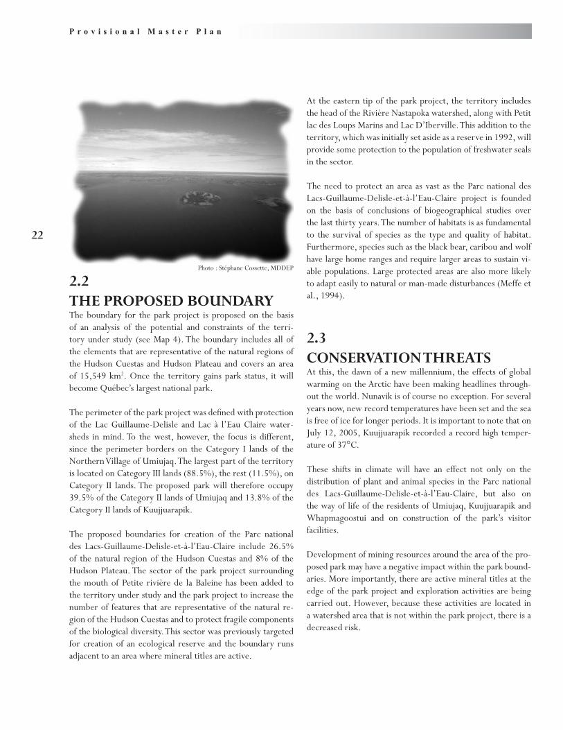
At the eastern tip of the park project, the territory includes the head of the Rivière Nastapoka watershed, along with Petit lac des Loups Marins and Lac D’Iberville. This addition to the territory, which was initially set aside as a reserve in 1992, will provide some protection to the population of freshwater seals in the sector.
The need to protect an area as vast as the Parc national des Lacs-Guillaume-Delisle-et-à-l’Eau-Claire project is founded on the basis of conclusions of biogeographical studies over the last thirty years. The number of habitats is as fundamental to the survival of species as the type and quality of habitat. Furthermore, species such as the black bear, caribou and wolf have large home ranges and require larger areas to sustain vi-able populations. Large protected areas are also more likely to adapt easily to natural or man-made disturbances (Meffe et al., 1994).
2.3CONSERVATION THREATSAt this, the dawn of a new millennium, the effects of global warming on the Arctic have been making headlines through-out the world. Nunavik is of course no exception. For several years now, new record temperatures have been set and the sea is free of ice for longer periods. It is important to note that on July 12, 2005, Kuujjuarapik recorded a record high temper-ature of 37°C.
These shifts in climate will have an effect not only on the distribution of plant and animal species in the Parc national des Lacs-Guillaume-Delisle-et-à-l’Eau-Claire, but also on the way of life of the residents of Umiujaq, Kuujjuarapik and Whapmagoostui and on construction of the park’s visitor facilities.
Development of mining resources around the area of the pro-posed park may have a negative impact within the park bound-aries. More importantly, there are active mineral titles at the edge of the park project and exploration activities are being carried out. However, because these activities are located in a watershed area that is not within the park project, there is a decreased risk.
2.2THE PROPOSED BOUNDARYThe boundary for the park project is proposed on the basis of an analysis of the potential and constraints of the terri-tory under study (see Map 4). The boundary includes all of the elements that are representative of the natural regions of the Hudson Cuestas and Hudson Plateau and covers an area of 15,549 km2. Once the territory gains park status, it will become Québec’s largest national park.
The perimeter of the park project was defined with protection of the Lac Guillaume-Delisle and Lac à l’Eau Claire water-sheds in mind. To the west, however, the focus is different, since the perimeter borders on the Category I lands of the Northern Village of Umiujaq. The largest part of the territory is located on Category III lands (88.5%), the rest (11.5%), on Category II lands. The proposed park will therefore occupy 39.5% of the Category II lands of Umiujaq and 13.8% of the Category II lands of Kuujjuarapik.
The proposed boundaries for creation of the Parc national des Lacs-Guillaume-Delisle-et-à-l’Eau-Claire include 26.5% of the natural region of the Hudson Cuestas and 8% of the Hudson Plateau. The sector of the park project surrounding the mouth of Petite rivière de la Baleine has been added to the territory under study and the park project to increase the number of features that are representative of the natural re-gion of the Hudson Cuestas and to protect fragile components of the biological diversity. This sector was previously targeted for creation of an ecological reserve and the boundary runs adjacent to an area where mineral titles are active.
Photo : Stéphane Cossette, MDDEP


25
Parc na t i onal d e s Lacs -Gui l laume -Del i s l e - e t -à - l ’Eau -Cla i re
2.4CHALLENGESTo date, the processes involved in creating the Parc national des Lacs-Guillaume-Delisle-et-à-l’Eau-Claire have taken place in a spirit of cooperation between the different interests repre-sented by the working group. Managing a park of this size is a challenge in itself, considering the difficulty accessing it and the costs associated with employee transportation. Once the park is created, administrators will face the following chal-lenges:
Ensure that the park’s ecological integrity, culture and •landscape heritage are preserved and protected.
Ensure that the activities and services available in the •park do not interfere with the harvesting rights of beneficiaries of the JBNQA.
Maintain an integrated environmental management •framework throughout the region.
Encourage the local Inuit and Cree communities to •protect the park’s natural and cultural heritage.
Provide a quality ecotourism product that will cater to •visitors.
Bolster economic benefits to local communities.•


27
Parc na t i onal d e s Lacs -Gui l laume -Del i s l e - e t -à - l ’Eau -Cla i re
The proposed conservation and development concept for the Parc national des Lacs-Guillaume-Delisle-et-à-l’Eau-Claire is based on a series of findings:
With an area covering more than 15,000 km• 2, the Parc national des Lacs-Guillaume-Delisle-et-à-l’Eau-Claire will be the largest park created in Québec to date.There is very little human activity in the park and the •level of ecological integrity is high.The territory has a wide variety of flora, fauna and •landform attractions.Climate changes have an impact on the distribution •of plant and animal species, as well as traditional Inuit and Cree activities.The ties that bond the Inuit and Cree to nature are an •important aspect of the reality of the region.The territory has a number of archeological sites and •great potential for exploration of new sites.
33 Conservation and development concept
The territory is of extreme historical importance be-•cause the Hudson Bay Company was present here for so many years.Under the JBNQA, beneficiaries of the agreement •are ensured harvesting rights, which distinguishes this park from Québec’s southern parks where wildlife har-vesting is prohibited, except sport fishing.The territory includes Category II lands.•Although the 55• th parallel is the administrative boundary of Cree and Inuit territories, the Cree of Whapmagoostui use the territory of the park. The territory is located far from large population cen-•tres and there are risks associated with this type of re-moteness.The region’s tourism lacks diversity.•Over a number of years, the Centre d’études nordiques •has gained expertise within the territory through the research projects it has conducted.
Photo : Jonathan Tessier

P r o v i s i o n a l M a s t e r P l a n
28
All aspects of park management must focus first and foremost on safeguarding the park’s ecological integrity, in other words, efforts will be make to preserve indigenous species and eco-systems, as well as the natural processes that shape and bring them together. Efforts will also be made to preserve the integ-rity of other types of heritage, namely the cultural and land-scape heritage. In Nunavik, the consensus is that the KRG will oversee efforts to preserve ecological integrity, in compliance with the conservation principle defined in Chapter 24 of the JBNQA.
Management orientations and the zoning plan can also serve as the basis for establishing long-term actions to achieve har-monious results, without harming the park’s prized features or the traditional activities of beneficiaries of the JBNQA.
3.1MANAGEMENT ORIENTATIONSConsultations between park administrators and the commun-ities concerned will be required to ensure protection of the natural, cultural and landscape heritage of the Parc national des Lacs-Guillaume-Delisle-et-à-l’Eau-Claire. The conserva-tion principle, which means preserving the inherent rights of the Inuit and Cree. Park management, must also include the firm cooperation of hunters, anglers and trappers who prac-tise traditional activities within the region.
To achieve these goals, once the park is created, a harmon-ization committee will be set up. The committee will consist of representatives from the Northern Villages of Umiujaq and Kuujjuarapik, the Anniturvik Landholding Corporation of Umiujaq, the Sakkuq Landholding Corporation of Kuuj-juarapik, the Cree nation of Whapmagoostui, the KRG, the Makivik Corporation, local association of hunters, anglers and trappers and the MDDEP. The role of the committee will be to discuss results that have been achieved and difficulties experienced once agreements related to the park’s creation have been implemented, make recommendations to the park’s superintendent for development of activities and services, and examine proposed scientific projects within the park. The committee will also play an important role to ensure that the harvesting rights of beneficiaries of the JBNQA are main-tained in the park. The committee will serve as the instrument through which the interests involved ensure that activities car-ried out in the park do not interfere with traditional Inuit and Cree subsistence activities.
The management orientations that are detailed in this docu-ment will serve to guide the actions of park administrators on issues of conservation, development, respect for the har-vesting rights of beneficiaries of the JBNQA, safety and ad-ministration.
3.1.1 CONSERVATIONThe document entitled “La politique sur les parcs. La con-servation” (MDDEP, pending) reaffirms the importance of al-lowing visitors to access Québec national parks to explore and recognize a park’s rich heritage. This document also lists three fundamental principles on which park conservation is based:
Conservation takes priority over development.•All aspects of heritage must be preserved.•Any decision made must be based on the precaution-•ary2 principle.
The integrity of an ecosystem is deemed to be preserved if:
its structure and function remain unchanged•its components and natural processes are likely to con-•tinue to existhuman activity and facilities do not interfere with an •ecosystem’s limited ability to support activities or level of activity, even after activities have finished
Enforcing the precautionary principle will help to manage the territory. This principle defines the approach that an adminis-trator must take when activities are believed to have an impact
2 As defined in section 6 of the Sustainable Development Act (R.S.Q., c. D-8.1.1).
Photo : Stéphane Cossette, MDDEP

29
Parc na t i onal d e s Lacs -Gui l laume -Del i s l e - e t -à - l ’Eau -Cla i re
on the heritage. This should not, however, be interpreted as an encouragement for restriction, but rather as an incentive to actively manage risks. Park management procedures will also be adapted to accommodate the northern environment. The park will have a heritage conservation plan to define firm courses of action to accommodate this need.
The general orientations to conserve and protect the natural cultural and landscape heritage are as follows:
Enforce the precautionary principle in all park develop-•ment activities, by respecting the carrying capacity of the natural environment.Conduct an assessment to determine how introducing •visitor and lodging facilities will impact the environment and communities, in accordance with guidelines issued by the Kativik Environmental Quality Commission.Improve awareness about the park’s heritage.•Examine stress that is generated as a result of park use •and stress from outside of the park that threatens or could threaten the heritage.Incorporate traditional Inuit and Cree knowledge in all •initiatives.Introduce procedures to monitor the status of the •park’s heritage.Use ecologically-sound operating practices.•
Administrators of the Parc national des Lacs-Guillaume-Delisle-et-à-l’Eau-Claire will have at their disposal certain tools to support their heritage and protection efforts. These tools include research, monitoring procedures and environ-mental stewardship programs.
ResearchResearch is an important service in national parks and is the perfect tool to achieve the heritage conservation objective. Research certifies that ecosystems and biodiversity within a park are managed correctly. It also helps to ensure that de-velopment initiatives do not endanger a region’s ecological integrity.
Given the representative nature of national parks and the degree to which natural and cultural heritage are protected, parks are ideal locations for research projects. Projects can be initiated by a park or by educational and research institutions. An information document will be made available to educa-tional and research institutions that would like to conduct re-
search projects informing them of the procedure to follow to receive an authorization.
Scientific research will be high on the agenda of the Parc national des Lacs-Guillaume-Delisle-et-à-l’Eau-Claire. There-fore, a research plan that prioritizes relevant study issues will be prepared once the park has been created. A research plan will be subsequently prepared in cooperation with the KRG and various partners, including the Centre d’études nordiques. The plan will take into account the Qaujisarvik network, the purpose of which is to oversee research activities in Nunavik. The following general orientations will apply when a research plan is drawn up:
Priority will be given to projects that focus on solving •park management problems.Projects that will provide additional insight into the •park’s natural and cultural heritage will be given pri-ority.Projects that add to the park’s educational program •will be endorsed.Projects that are accepted must be approved by com-•munities in the region and, where possible, must incor-porate traditional knowledge.
Monitoring Heritage StatusEcological integrity is not something that is static. Variations in ecological integrity are measurable. The status of an ecosystem can change and continue to preserve its ecological integrity if the changes it undergoes are acceptable or simply a part of nature. The heritage conservation plan will also target issues associated with management of the park’s natural and cultural heritage in relation to activities that are proposed and the facilities available. Indicators must be introduced to monitor the “health status” of the park’s main ecosystems and to verify their ability to evolve, develop and adapt to changes. The biological and ecological pro-cesses that control them will also be monitored to determine the ability of flora and fauna to adapt to stressors and regenerate. The heritage conservation plan will ensure that measures are taken to avoid or mitigate impacts once development takes place in the park.
Monitoring programs and research adapted to the park situation and possible future emergencies park superintendents may en-counter will help to adjust, change or prohibit certain park activ-ities and provide remedies to restore disturbed habitats.

P r o v i s i o n a l M a s t e r P l a n
30
The following orientations will apply when monitoring proced-ures are drafted:
Create partnerships with experienced researchers.•Incorporate traditional Inuit and Cree knowledge.•
Environmental StewardshipGovernment agencies and national parks in particular must sup-port environmentally friendly practices that are above reproach. Environmental stewardship will contribute to the “greening” of park management initiatives because it will promote procedures based on efficiency and conservation.
The following general environmental stewardship orientations will apply to the Parc national des Lacs-Guillaume-Delisle-et-à-l’Eau-Claire:
Minimize local greenhouse gas emissions.•Limit the amount of drinking water used for sanitation •purposes.Develop effective methods to treat small amounts of •wastewater, which are also adapted to the climate.Minimize the amount of waste generated by encouraging •reduction, reuse and recycling.Comply with and exceed standards when purchasing, •handling and storing petroleum products.Erect energy-efficient buildings.•Encourage use of certified building materials, such as the •FSC standard for forestry products.
3.1.2 DEVELOPMENT OF THE NATURAL ANDCULTURAL HERITAGEFor visitors, the mission of Québec’s national parks will become apparent through the activities and services that are available to them. Like other national park networks elsewhere in the world, this mission consists of ensuring the conservation of representative or exceptional features of the natural heritage and promoting local heritage by offering exploration activities that show consideration for the heritage and its related culture (Société de la faune et des parcs du Québec, 2002).
The type of activities and services available in Québec national parks is based on the three following principles:
Activities and services must exert a minimum accept-•able impact on the heritage.
Activities and services must promote discovery of the •heritage.Activities and services must promote accessibility.•
These three principles must be considered an inseparable unit. The first principle, however, takes precedence, pursuant with requirements set forth in section 3.1.1 of this document. Therefore, an activity or service that does not comply with the first principle is not in harmony with the purpose of Québec national parks. In addition to compliance with these three principles, the activities and services that are offered must not conflict with traditional Cree and Inuit activities.
In an effort to promote learning, the park will have an edu-cation strategy, which will serve as the reference framework to plan and develop educational activities. The strategy will describe the client groups and objectives of the educational activity, themes that will have to be developed and the edu-cational methods proposed. The educational strategy will also target short-term and medium-term initiatives that must be achieved.
The program of recreational and educational activities in the Parc national des Lacs-Guillaume-Delisle-et-à-l’Eau-Claire will comply with the following orientations:
Educational activities will be based on, among other •things, the expertise acquired by the Centre d’études nordiques and on traditional Inuit and Cree know-ledge.Educational activities will focus on establishing a close •and significant bond between visitors and the protected heritage to foster an interest to explore the diversity of the heritage and the role and value of this diversity.
Photo : Robert Fréchette, ARK

31
Parc na t i onal d e s Lacs -Gui l laume -Del i s l e - e t -à - l ’Eau -Cla i re
Educational activities will encourage visitors to make a •firm commitment to the conservation mission.The educational activities that are provided must be •centred on a recreational-educational method and an environmental education approach.Educational activities will promote the Inuit and Cree •cultures and underscore how both nations were able to live together within the territory.Educational activities should be designed for school •groups and could be incorporated into the Nunavik school curriculum.Educational activities will raise visitor awareness about •the importance of complying with park regulations.Activities and services will be geared mainly to visitors •who have experience in remote environments and who are used to exposure to harsh weather conditions. Al-though, some services can be adapted to groups who require more supervision or who seek more comfort.The recreational activities and services offered will be •based on the vulnerability of the natural heritage, the distances that have to be travelled and the few number of visitors expected.
3.1.3 PROTECTION OF THE RIGHTS OFBENEFICIARIES OF THE JBNQAAlthough it has been clearly established that the JBNQA super-sedes the Parks Act, which guarantees that beneficiaries of the agreement can continue their traditional activities within the park, the fact remains that traditional activities that are prac-tised alongside activities available to visitors may affect the way of life of the Inuit or Cree. During the planning phase of the park project, the Inuit of Umiujaq expressed concern about the presence of visitors in some sectors of the park, not only for fear of a poor understanding of their way of life, but for safety reasons.
The activities and services available in the Parc national des Lacs-Guillaume-Delisle-et-à-l’Eau-Claire are not expected to significantly impact the harvesting rights of Cree and Inuit. Park administrators will therefore have to adjust the types of activities and services offered to visitors on the basis of where and when traditional activities are carried out.
The following orientations will guide administrators to ensure that the rights of beneficiaries of the JBNQA are respected within the park:
Use of the harmonization committee as a consultation •mechanism between various interests to ensure that the rights of beneficiaries of the JBNQA are protected.Examine the option of introducing a procedure to •monitor traditional activities.Notify visitors that they may come across Cree and •Inuit who are practising traditional subsistence activ-ities in the park.
3.1.4 SAFETYThe territory of the Parc national des Lacs-Guillaume-Delisle-et-à-l’Eau-Claire abounds with many natural hazards due to the presence of cliffs, cold water, rugged weather and wildlife. As a result of the isolation and remoteness, even a small ac-cident could endanger the lives of victims. Even if help can be contacted quickly, it could take several hours or days before assistance arrives, weather permitting and provided a helicop-ter is available.
The park will have an emergency response plan that will detail the names of individuals in charge and define procedures in the event of incidents that may jeopardize the safety of park users or the quality of the environment. The following policies will guide administrators of the Parc national des Lacs-Guillaume-Delisle-et-à-l’Eau-Claire on safety matters:
Adopt an approach aimed at prevention to avoid ac-•cidents. Encourage visitors who have little experience or lim-•ited technical knowledge to hire local guides.
3.1.5 ADMINISTRATION AND REGIONALDEVELOPMENTThe participation of Inuit in developing and managing parks in Nunavik is a formal commitment on the part of the Québec government that was made on April 9, 2002, during the signing of the Partnership Agreement on Economic and Community Development in Nunavik. A specific agreement will also be concluded with the KRG to transfer responsibility of park activities and services to the KRG, along with responsibility for building and maintaining facilities. In the case of the Parc national des Lacs-Guillaume-Delisle-et-à-l’Eau-Claire, participation will be broadened to include the Cree nation of Whapmagoostui.
Although the initial focus of Québec’s national parks is to preserve heritage, park projects also benefit the local econ-
P r o v i s i o n a l M a s t e r P l a n
32
available, changes will be made to the zoning plan to ensure compliance with the park’s conservation mandate.
The Parc national des Lacs-Guillaume-Delisle-et-à-l’Eau-Claire project includes four categories of zones: maximum preservation zones, preservation zones, ambience zones and service zones.
3.2.1 MAXIMUM PRESERVATION ZONESThree maximum preservation zones have been set aside within the Parc national des Lacs-Guillaume-Delisle-et-à-l’Eau-Claire project. These zones cover a total area of 31,6 km2, repre-senting approximately 0,1% of the park’s area. Therefore, no activity and no harvesting will be allowed in these zones, ex-cept for beneficiaries of the JBNQA. Scientific research and some educational activities may be authorized by the park superintendent, under certain conditions and on presentation of a detailed description of the project, demonstrating that the techniques in use comply with the park’s conservation object-ives.
The purpose of the first two maximum preservation zones is to ensure maximum protection of the cliffs located on either side of Petite rivière de la Baleine. Covering an area of 30 km2, these zones protect an important nesting habitat for the pere-grine falcon and golden eagle. The cliffs are also a site of inter-est for vascular and invascular plant species. The cliffs contain large numbers of calcicole species and rare species in Canada likely to be designated threatened or vulnerable in Québec.
The third maximum preservation zone includes four small islands in Lac Guillaume-Delisle. Together, the islands cover a total area of 1,6 km2. This maximum preservation zone will protect a site of interest for invascular plant species, more spe-cifically mosses, as well as a nesting habitat of the common eider.
3.2.2 PRESERVATION ZONESMost of the area (11 952,8 km2, representing 77%) of the territory of the Parc national des Lacs-Guillaume-Delisle-et-à-l’Eau-Claire will be designated preservation. Visitors will be instructed not to interfere with the most vulnerable com-ponents and no motorized vehicles or sport fishing will be al-lowed. Huts will be built and camping will be allowed along long hiking trails. The use of huts and camps will be governed by an environmental code of ethics that will be defined in the Heritage Conservation Plan.
omy. For a small community such as Umiujaq, the economic benefits generated by park activities will be important. The following policies will apply to administration and regional development:
Encourage the hiring of residents of Umiujaq, •Kuujjuarapik and Whapmagoostui.Call on local businesses to manage certain activities •or services.Work in cooperation with local organizations.•Continue to involve local associations in the park’s de-•velopment.Provide training that is adapted to the needs of jobs •that are available.
3.2ZONINGA zoning plan sets out the legal guidelines necessary to deter-mine park protection and development targets for each unit in the park. This is the first step to fulfilling the policies listed in the section above. It is also important to underscore the fact that guidelines and regulations associated with the zoning plan have no bearing on harvesting rights granted to beneficiaries of the JBNQA.
The zoning plan of the Parc national des Lacs-Guillaume-Delisle-et-à-l’Eau-Claire (see Map 5) includes the following components:
Representation of components of the natural region.•The presence of sensitive habitats or, where this is not •the case, sectors that have a greater carrying capacity.The presence or potential presence of rare plant or •wildlife species or species that are deemed threatened or vulnerable.The presence of archeological sites or burial grounds.•The presence of sacred places or sites of cultural im-•portance.Current use of the territory by the residents of Umiu-•jaq, Kuujjuarapik and Whapmagoostui.Facilities present within the territory.•The relative difficulty accessing the territory.•The anticipated number of visitors.•
The zoning plan has been drafted based on current knowledge of the territory. Over time and as new information becomes


35
Parc na t i onal d e s Lacs -Gui l laume -Del i s l e - e t -à - l ’Eau -Cla i re
The last two ambience zones will be located east of Lac à l’Eau Claire and will include Lac Rousselin and an unnamed lake east of Lac D’Iberville. Although no development in the sector is expected in the short term, designation as an ambience zone will allow future access to the sector by seaplane and access to current facilities.
3.2.4 SERVICE ZONESService zones will cover a small area of the park project (7,5 km2). This zoning category was allocated to these areas because they have a superior carrying capacity and because of the existing occupation. These sites are set aside for use as the main points of access to the park and to build lodging facilities that offer more amenities and services. The areas can also be used to store material to operate the park or to set up automated weather forecasting stations. The Parc national des Lacs-Guillaume-Delisle-et-à-l’Eau-Claire project contains four service zones.
The first is located on the eastern shore of Lac Guillaume-Delisle, at the mouth of Rivière à l’Eau Claire. This location is ideal for development of the historical heritage this sector has to offer, because it was an important meeting place. Manage-ment of this zone will require particular attention due to the presence of archeological sites.
The second service zone is located at the outlet of Lac à l’Eau Claire. The buildings of an outfitting operation currently oc-cupy the site. This is the ideal starting point for a canoe or kayak expedition along Rivière à l’Eau Claire.
The third service zone is also located on the edge of Lac à l’Eau Claire, on the north shore of the western basin of the lake. Buildings belonging to the KRG currently occupy the site and are used mainly for scientific research purposes.
The fourth service zone is located east of Lac D’Iberville on the edge of an unnamed lake and includes, among other things, existing buildings that belong to an outfitter operation. Desig-nation as a service zone will meet the long-term needs that may arise for development of the Petit lac des Loups Marins sector. Before any development takes place in this sector, how-ever, more information about the population of freshwater seals will be required.
3.2.3 AMBIENCE ZONESAmbience zones will be subject to less restrictive exploration of the park. Unlike, preservation zones, motorized vehicles can be used for transportation (plane, snowmobile and boat) and different types of lodging facilities are allowed. Sport fish-ing will be allowed in bodies of water that are located within an ambience zone. Ambience zones cover the main traffic cor-ridors through which visitors travel to the park’s main points of interest. The Parc national des Lacs-Guillaume-Delisle-et-à-l’Eau-Claire project includes six ambience zones, covering an area of 3 557 km2, or 22,9% of the territory.
The first ambience zone follows the corridor of the Petite rivière de la Baleine and extends 200 m on either side of the river. This zone will provide access to this history-rich sector. It will also provide an unprecedented view of the spectacular landscape of the Hudson Cuestas.
The second ambience zone surrounds Lac Guillaume-Delisle, except for its islands, which will be zoned preserva-tion, a 15 km tract of land stretching from the shoreline of the lake, and a portion of the Caribou and De Troyes rivers. Lac Guillaume-Delisle is used extensively by residents of Umiujaq for traditional subsistence activities. Although the lake can be accessed through the ambience zone, restrictions may apply in some locations or during certain periods of the year to prevent conflicts over use of the area. This situation applies particularly to Kilualuk Bay, southwest of Lac Guillaume-Delisle, which is an important location for beluga hunting. During hunting season, visitors will be allowed to access this location only in the company of a guide, for safety reasons.
The third ambience zone, which will serve as a link between Lac Guillaume-Delisle and Lac à l’Eau Claire, extends on either side of Rivière à l’Eau Claire. This zone includes the his-torical route Natives and early explorers used to travel from the Hudson Bay coastline to Ungava Bay. The sector continues to be used today by the Cree of Whapmagoostui to travel to Lac à l’Eau Claire by snowmobile in winter.
The fourth ambience zone includes Lac à l’Eau Claire, except for its islands, which will be zoned preservation. This zone ex-tends beyond the shorelines of the lake to include a sector used mainly by the Cree of Whapmagoostui, near Rivière Noonish. The sector was also used by outfitters for angling activities.

P r o v i s i o n a l M a s t e r P l a n
36
3.3PARK DEVELOPMENTThe territory of the Parc national des Lacs-Guillaume-Delisle-et-à-l’Eau-Claire is notable for its virtually pristine natural environment. It is therefore only fitting that its development reflects this intrinsic wealth, uncommon in the modern world. The development concept offers an original ecotourism product to explore the park’s main attractions, including Lac Guillaume-Delisle and Lac à l’Eau Claire. It also prioritizes conservation of the region’s extraordinary natural heritage that is representative of the natural regions of the Hudson Cuestas and Hudson Plateau. To avoid adding facilities in the park, the MDDEP wants to purchase existing buildings, such as outfitter camps and a vacation cabin, and use them for park purposes. Until the facilities have been purchased, their owners will be allowed to continue to pursue activities in accordance with the Parks Act.
The main components of the park’s development concept are de-tailed in Map 6, and the equipment required is described in the sections that follow.
3.3.1 VISITOR CENTRE AND SERVICESThe Northern Village of Umiujaq will be the principal point of service for the park. The village will serve as the park’s outpost, where visitors can receive information about their visit to the park and where they can rent special gear. A location will be chosen in the village to establish a visitor and service centre, which will also house the park’s administrative services. A site will also be selected to build a warehouse for use as a facility to maintain and store equipment.
A second visitor and service centre will also be established in Kuujjuarapik-Whapmagoostui. This location will provide visitors basic information about their stay in the park, mainly for the Lac à l’Eau Claire sector, but may also provide information about how to access the Petite rivière de la Baleine and Lac Guillaume-Delisle sectors by boat or snowmobile.
To maintain control of activities and for safety reasons, visitors will be required to register before entering the park and sign out upon leaving.
3.3.2 ACCESS TO THE PARKAccess to this large territory is the framework of the entire development concept for the Parc national des Lacs-Guillaume-Delisle-et-à-l’Eau-Claire project. There are a number of ways
to access the territory, which vary according to season and the sector visitors would like to explore. The villages of Umiujaq, Kuujjuarapik and Whapmagoostui will be the main points of entry. All three villages are accessible only by plane, from Montréal or from villages connected to the James Bay Road.
From these villages, the principal means of transportation to access the park are plane, boat and snowmobile. The park can also be accessed using a helicopter, but this type of transpor-tation will be reserved mainly for park management needs. The high cost of chartering a helicopter and limited passenger space make it less suitable than a plane for carrying visitors and luggage.
The Lac Guillaume-Delisle and Petite rivière de laBaleine SectorThe main access route to this sector of the park is from the vil-lage of Umiujaq, but it can also be accessed from Kuujjuarapik. An existing road links the village of Umiujaq to the northern tip of Lac Guillaume-Delisle. This road, however, will have to be improved and completed for safety reasons. In addition to providing access to the park, this road will make it easier for residents of Umiujaq to access the park. Given the relatively short distance between the village and the northern tip of the lake, which is approximately 10 km, the sector can even be ac-cessed by travel on foot. A floating dock will be built at the end of the road. This will be the point of departure for excursions by boat or sea kayak.
In summer, the Lac Guillaume-Delisle and Petite rivière de la Baleine sector can also be accessed by boat from the coastline of Hudson Bay by entering the lake through the Goulet channel. From Umiujaq, it takes approximately one hour to travel to the Goulet, and five and a half hours from Kuujjuarapik, weather permitting.
In winter, the sector can be accessed by snowmobile, since the frozen lake makes travel easier. Individuals travelling on Lac Guillaume-Delisle, however, should be accompanied by a guide. Some locations are hazardous in winter due to open water or thin ice. This is particularly true in the case of the Goulet and in areas around river mouths.


39
Parc na t i onal d e s Lacs -Gui l laume -Del i s l e - e t -à - l ’Eau -Cla i re
This provisional master plan proposes development of a small portion of the territory for some current popular recreational activities. Visitors who would like to take part in activities other than those listed in this document, will be required to obtain authorization from the park’s superintendent, who will examine applications in accordance with park policy regarding activities and services. Visitors will also not be restricted to locations indicated on the map to participate in activities that are allowed within the park. Visitors can prepare their own itinerary to tour different areas of the park, in accordance with restrictions that apply to each zone. Visitors can plan the type of excursion with or without the presence of a guide. Visitors who venture into the territory without a guide and for an ex-tended period will be required to prove that they have the skills necessary to do so and that they have the equipment needed to ensure survival. Weather conditions, terrain and encounters with wild animals are factors that can complicate an outing. When they register, visitors will be required to submit a copy of their itinerary to park officials. This will simplify search ef-forts in the event emergency assistance is required.
The Lac à l’Eau Claire SectorThe main point of entry to Lac à l’Eau Claire is through the Northern Village of Whapmagoostui, where visitors will find experienced guides. The sector can also be accessed through Umiujaq.
During summer, the Lac à l’Eau Claire sector will be accessible by bush plane or seaplane, in designated locations only. A terrace is currently in use to land bush planes (Twin Otter planes), but to simplify park operations, the option to develop an airstrip in the service zone on the north shore of the western basin of the lake should be examined, near existing buildings. Two locations have also been set aside for access by seaplane on Lac à l’Eau Claire. The first is located at the outlet of the lake, the second is located southwest of the eastern basin of the lake. These points of entry will provide access to facilities planned nearby. In the company of a guide, visitors can also travel over the lake by motor boat to explore points of interest.
During winter, the Lac à l’Eau Claire sector can be accessed by plane, but snowmobile is the most cost-efficient means of travel. The main access route to the lake is to follow Rivière à l’Eau Claire, which is the historical route used by early explor-ers. According to Cree tallymen who use the route, the trail will have to be marked out, because it is used less often these days. If weather conditions are favourable, visitors can travel from Umiujaq to Lac à l’Eau Claire in one day.
3.3.3 ACTIVITIESAs with all Québec parks, exploring and enjoying the Parc national des Lacs-Guillaume-Delisle-et-à-l’Eau-Claire will depend on recreational and educational activities. Education will be the most effective means of facilitating and encouraging exploration, by explaining the significance of certain natural features and landscapes to visitors.
To explore landscapes and appreciate the wealth of biological diversity, a variety of outdoor activities will be available to vis-itors. These activities will also serve as a means to access points of interest. Since water figures prominently in the park, water activities such as sea kayaking, canoeing and motor boat ex-cursions will be offered in summer. Hiking will also be avail-able, but in conjunction with other activities. In winter, nordic skiing, paraskiing, snowshoeing and dogsledding will provide memorable excursions over frozen surfaces and in snow-laden valleys.
Photo : Jonathan Tessier

P r o v i s i o n a l M a s t e r P l a n
40
the age and condition of buildings, the structures should be re-inforced to ensure safety of the premises.
Whitewater AdventuresWhether it is in a canoe, kayak or inflatable raft, the territory of the Parc national des Lacs-Guillaume-Delisle-et-à-l’Eau-Claire is a prime location for several days of whitewater adventures. Rivière à l’Eau Claire offers significant potential for this type of activity. This is a river that offers a high degree of difficulty due to the presence of category RIII and RIV rapids, drops and heads. Visitors who wish to avoid these obstacles, however, can follow portage trails, which can sometimes be long, for example, at the end of the course near Lac Guillaume-Delisle. Although portage trails have been used numerous times in the past, they will have to be clearly marked along the river for the safety of less experi-enced paddlers.
Canoeists who prefer calmer waters can follow the historical route early explorers used to travel between these two huge lakes. The route includes travel along the à l’Eau Claire and De Troyes rivers and over a series of lakes between the rivers to avoid rougher waters. The route, which can be travelled in both directions, does require a number of portages however. Individ-uals who seek more adventure can extend their trip by taking the route early explorers used to travel to Ungava Bay, by way of Lac à l’Eau Claire, Lacs des Loups Marins and Rivière aux Mélèzes.
Sea KayakingLarge bodies of waters such as Lac Guillaume-Delisle and Lac à l’Eau Claire are ideal for sea kayaking activities. In addition to physical activity, sea kayaking provides an opportunity for visitors to travel to different hot spots in the park.
At the northern tip of Lac Guillaume-Delisle, a floating dock will be available to visitors to launch boats and will serve as the departure point for excursions. Travel is easier on the eastern part of the lake, especially in windy conditions. On the lake, kayakers will have the opportunity to observe beluga and seals as they survey the steep cliffs that fringe the western shore-line.
Kayaking activities on Lac à l’Eau Claire can begin at facilities located at the outlet of the lake. Visitors can then follow the north shore and navigate between islands for protection from the wind and high waves. Caution should be exercised when travelling to the central islands due to the distance and surging waves during strong winds.
EducationIn the Parc national des Lacs-Guillaume-Delisle-et-à-l’Eau-Claire, education will be the principle medium to introduce visitors to the park’s natural and cultural heritage. Visitor edu-cation will also focus on the importance of their involvement to conserve the park’s heritage and ensure compliance with park regulations.
Through education, visitors will:
Understand the underlying objectives that are part of •the reason national parks were created and their contri-bution to the network of protected areas in Québec.Identify with and respect the way of life of the Inuit and •Cree who rely on the resources of the territory.Absorb themselves in atmospheres unique to the park’s •wide open spaces.Understand the risks involved with certain types of ac-•tivities.
Efforts will also be made to educate the residents of Umiujaq, Kuujjuarapik and Whapmagoostui. This will help advance and preserve traditions unique to the Inuit and Cree culture. An edu-cation program geared particularly to young people will also be introduced.
The educational initiatives that park administrators introduce will focus on the natural, cultural and landscape heritage of the Parc national des Lacs-Guillaume-Delisle-et-à-l’Eau-Claire. Attention will also centre on heritage attractions located in areas around the park.
Visitor education will begin in the villages of Umiujaq and Kuujjuarapik-Whapmagoostui where a permanent exhibit will be on display in the visitor and service centre. The purpose of the exhibit will be to encourage visitors to explore the park’s main attractions and learn about some of the aspects of the park’s rich cultural heritage and the surrounding communities.
In addition to the exhibit, administrators will be using other types of media to highlight the heritage of the region and park: guided or self-guided tours, brochures, posters in shelters, in-terpretive talks, live demonstrations, activities to share Inuit and Cree culture, etc. Interpretation activities of historical heritage will focus attention on the fur trade within the park. The pres-ence of buildings on the south shore of Lac Guillaume-Delisle is an asset when interpretation or tour activities are planned. Given

41
Parc na t i onal d e s Lacs -Gui l laume -Del i s l e - e t -à - l ’Eau -Cla i re
cluding those on the à l’Eau Claire and De Troyes rivers. This is also where visitors can begin retracing the historical portage trail travelling up Rivière à l’Eau Claire to its source.
The development potential for hiking along Lac à l’Eau Claire is not as good. The unchanging landscape can make hiking monotonous, especially over long distances. At some high points along the shoreline, however, hikers can view the vast-ness of the lake’s water mass. The central islands of the lake also feature remarkable phenomena associated with freezing temperatures and ice movement
Sport FishingSport fishing will be a secondary activity in the Parc national des Lacs-Guillaume-Delisle-et-à-l’Eau-Claire and will be available only in ambience zones. Visitors will therefore be allowed to fish on Lac Guillaume-Delisle, Rivière à l’Eau Claire, Rivière de Troyes and on Lac à l’Eau Claire. It is important to note that in addition to holding a provincial fishing licence, visitors who would like to fish on Lac Guillaume-Delisle or another body of water located on Category II lands will be required to receive authorization from the Landholding Corporations of Umiujaq or the Landholding Corporation of Kuujjuarapik, depending on the sector chosen.
Skiing and SnowshoeingIn winter, ice and snow cover make travel through the park easier. In the Lac Guillaume-Delisle sector, travel can be haz-ardous along the edge of cliffs. As winds blows snow, significant amounts of snow can accumulate along ledges and result in ava-lanches. Further inland, conditions vary according to wind ex-posure. Along valley floors, snow is more abundant but lighter. More exposed areas have less snow, but it is more compact and offers less adherence. Sturdy crampons are therefore a must.
Exploring the plateau between Lac Guillaume-Delisle and Lac à l’Eau Claire will be easier during longer outings with these types of activities. Visitors who have less experience using navi-gational equipment will be able to follow the marked snow-mobile trail. Over time, however, additional skiing and snow-shoeing trails may be marked out.
ParaskiingParaskiing is an activity that is growing in popularity through-out Québec and can be practised in summer (using water skis or wakeboard) or winter (using skis or snowboard). Due to cold water temperatures in summer, however, this sport will be
HikingHiking is definitely an activity that most park visitors will be able to access, since it requires little special equipment and no particular technique. The sectors of Lac Guillaume-Delisle and Petite rivière de la Baleine offer the best potential for this activity due to the variety of landscapes and unparalleled view-points available. Hiking along the dip slopes of cuestas is made easier with the almost total absence of high vegetation and a uniform layer of basalt. From the highest ridges, visitors can survey the vastness of the Hudson Plateau. At the foot of the cliffs that plummet into the Petite rivière de la Baleine, vis-itors can observe beluga as they commune during the month of August. Not far from Lac Qasigialik (Petite rivière de la Ba-leine), a series of hills devoid of vegetation provides an excel-lent vantage point to view the cliffs and examine how erosion has shaped this part of the territory.
Hiking trails will also be available along the eastern shoreline of Lac Guillaume-Delisle. The breaking point between the pla-teau and the graben of the lake is particularly evident along rivers. The topography has created picturesque waterfalls, in-
Photo : Jean Gagnon, MDDEP
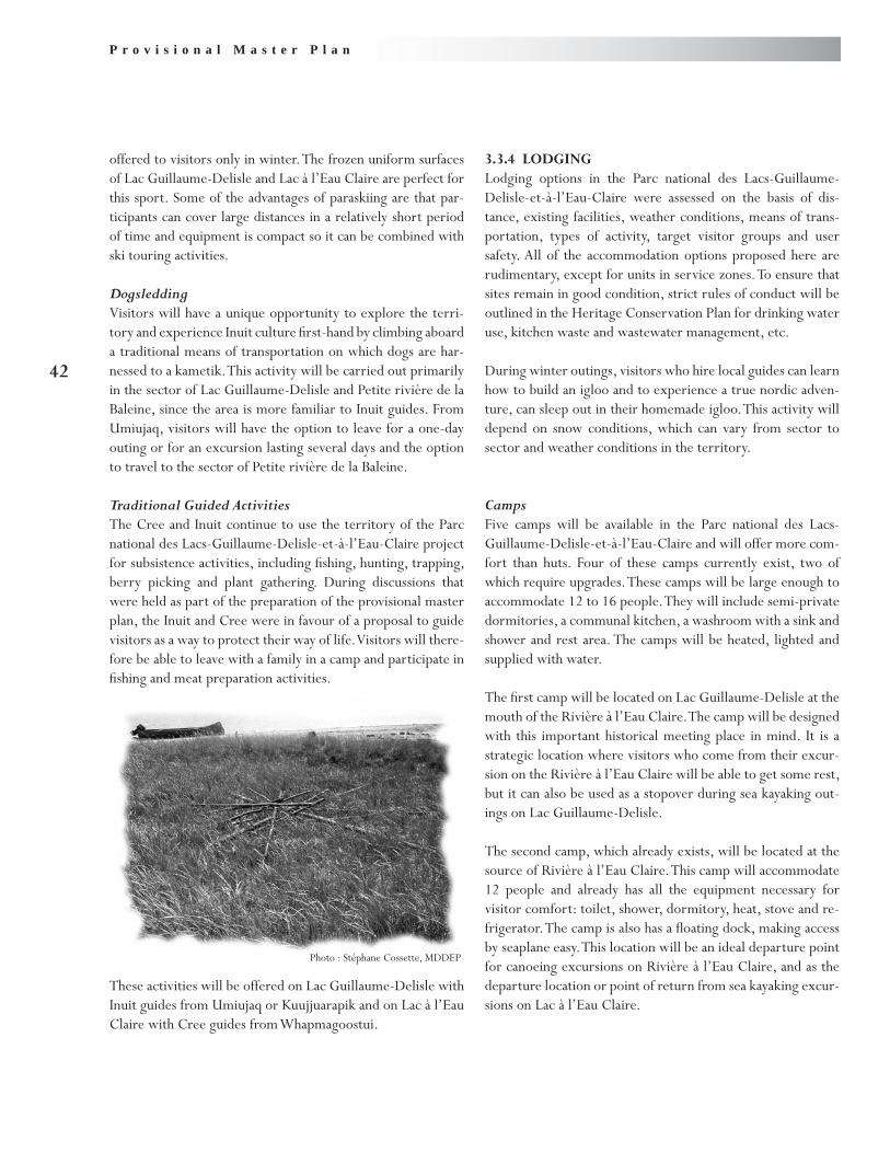
P r o v i s i o n a l M a s t e r P l a n
42
offered to visitors only in winter. The frozen uniform surfaces of Lac Guillaume-Delisle and Lac à l’Eau Claire are perfect for this sport. Some of the advantages of paraskiing are that par-ticipants can cover large distances in a relatively short period of time and equipment is compact so it can be combined with ski touring activities.
DogsleddingVisitors will have a unique opportunity to explore the terri-tory and experience Inuit culture first-hand by climbing aboard a traditional means of transportation on which dogs are har-nessed to a kametik. This activity will be carried out primarily in the sector of Lac Guillaume-Delisle and Petite rivière de la Baleine, since the area is more familiar to Inuit guides. From Umiujaq, visitors will have the option to leave for a one-day outing or for an excursion lasting several days and the option to travel to the sector of Petite rivière de la Baleine.
Traditional Guided ActivitiesThe Cree and Inuit continue to use the territory of the Parc national des Lacs-Guillaume-Delisle-et-à-l’Eau-Claire project for subsistence activities, including fishing, hunting, trapping, berry picking and plant gathering. During discussions that were held as part of the preparation of the provisional master plan, the Inuit and Cree were in favour of a proposal to guide visitors as a way to protect their way of life. Visitors will there-fore be able to leave with a family in a camp and participate in fishing and meat preparation activities.
These activities will be offered on Lac Guillaume-Delisle with Inuit guides from Umiujaq or Kuujjuarapik and on Lac à l’Eau Claire with Cree guides from Whapmagoostui.
3.3.4 LODGINGLodging options in the Parc national des Lacs-Guillaume-Delisle-et-à-l’Eau-Claire were assessed on the basis of dis-tance, existing facilities, weather conditions, means of trans-portation, types of activity, target visitor groups and user safety. All of the accommodation options proposed here are rudimentary, except for units in service zones. To ensure that sites remain in good condition, strict rules of conduct will be outlined in the Heritage Conservation Plan for drinking water use, kitchen waste and wastewater management, etc.
During winter outings, visitors who hire local guides can learn how to build an igloo and to experience a true nordic adven-ture, can sleep out in their homemade igloo. This activity will depend on snow conditions, which can vary from sector to sector and weather conditions in the territory.
CampsFive camps will be available in the Parc national des Lacs-Guillaume-Delisle-et-à-l’Eau-Claire and will offer more com-fort than huts. Four of these camps currently exist, two of which require upgrades. These camps will be large enough to accommodate 12 to 16 people. They will include semi-private dormitories, a communal kitchen, a washroom with a sink and shower and rest area. The camps will be heated, lighted and supplied with water.
The first camp will be located on Lac Guillaume-Delisle at the mouth of the Rivière à l’Eau Claire. The camp will be designed with this important historical meeting place in mind. It is a strategic location where visitors who come from their excur-sion on the Rivière à l’Eau Claire will be able to get some rest, but it can also be used as a stopover during sea kayaking out-ings on Lac Guillaume-Delisle.
The second camp, which already exists, will be located at the source of Rivière à l’Eau Claire. This camp will accommodate 12 people and already has all the equipment necessary for visitor comfort: toilet, shower, dormitory, heat, stove and re-frigerator. The camp is also has a floating dock, making access by seaplane easy. This location will be an ideal departure point for canoeing excursions on Rivière à l’Eau Claire, and as the departure location or point of return from sea kayaking excur-sions on Lac à l’Eau Claire.
Photo : Stéphane Cossette, MDDEP
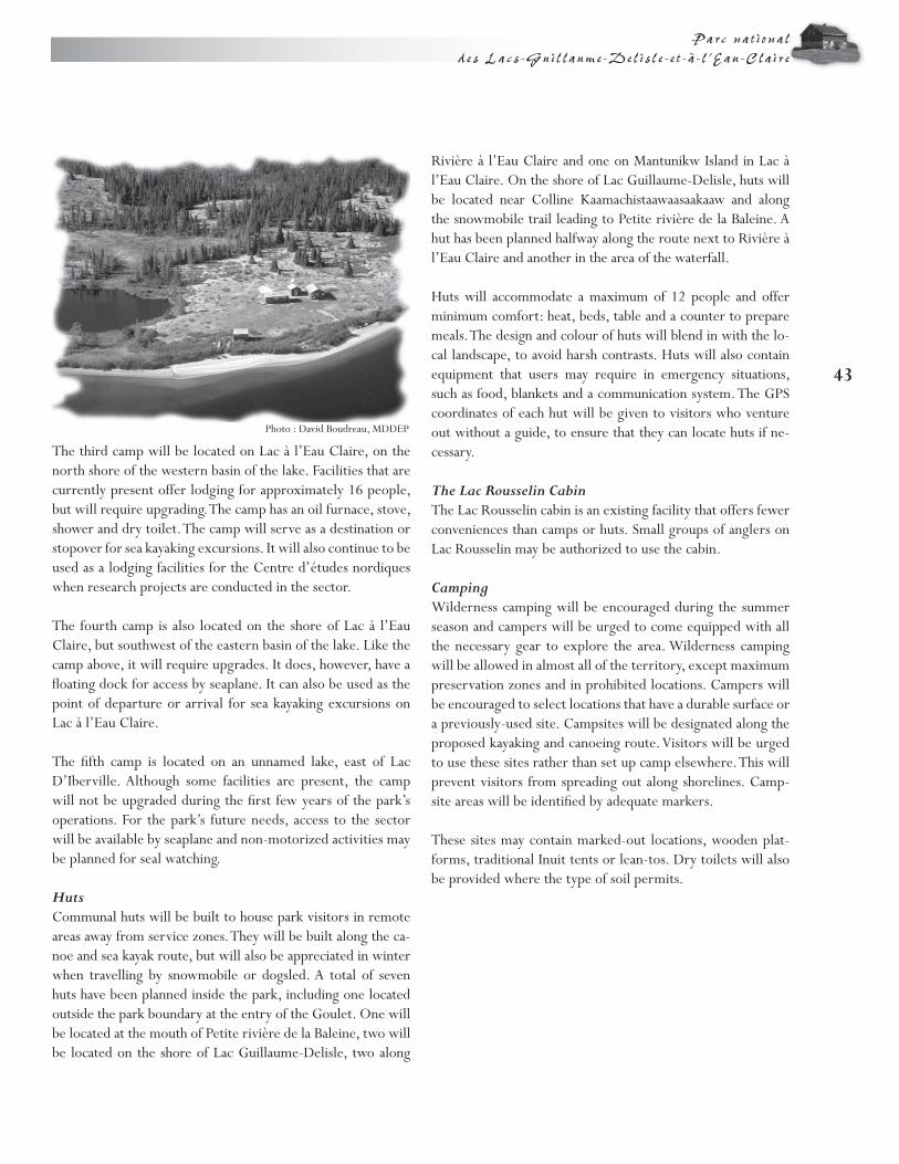
43
Parc na t i onal d e s Lacs -Gui l laume -Del i s l e - e t -à - l ’Eau -Cla i re
Rivière à l’Eau Claire and one on Mantunikw Island in Lac à l’Eau Claire. On the shore of Lac Guillaume-Delisle, huts will be located near Colline Kaamachistaawaasaakaaw and along the snowmobile trail leading to Petite rivière de la Baleine. A hut has been planned halfway along the route next to Rivière à l’Eau Claire and another in the area of the waterfall.
Huts will accommodate a maximum of 12 people and offer minimum comfort: heat, beds, table and a counter to prepare meals. The design and colour of huts will blend in with the lo-cal landscape, to avoid harsh contrasts. Huts will also contain equipment that users may require in emergency situations, such as food, blankets and a communication system. The GPS coordinates of each hut will be given to visitors who venture out without a guide, to ensure that they can locate huts if ne-cessary.
The Lac Rousselin CabinThe Lac Rousselin cabin is an existing facility that offers fewer conveniences than camps or huts. Small groups of anglers on Lac Rousselin may be authorized to use the cabin.
CampingWilderness camping will be encouraged during the summer season and campers will be urged to come equipped with all the necessary gear to explore the area. Wilderness camping will be allowed in almost all of the territory, except maximum preservation zones and in prohibited locations. Campers will be encouraged to select locations that have a durable surface or a previously-used site. Campsites will be designated along the proposed kayaking and canoeing route. Visitors will be urged to use these sites rather than set up camp elsewhere. This will prevent visitors from spreading out along shorelines. Camp-site areas will be identified by adequate markers.
These sites may contain marked-out locations, wooden plat-forms, traditional Inuit tents or lean-tos. Dry toilets will also be provided where the type of soil permits.
The third camp will be located on Lac à l’Eau Claire, on the north shore of the western basin of the lake. Facilities that are currently present offer lodging for approximately 16 people, but will require upgrading. The camp has an oil furnace, stove, shower and dry toilet. The camp will serve as a destination or stopover for sea kayaking excursions. It will also continue to be used as a lodging facilities for the Centre d’études nordiques when research projects are conducted in the sector.
The fourth camp is also located on the shore of Lac à l’Eau Claire, but southwest of the eastern basin of the lake. Like the camp above, it will require upgrades. It does, however, have a floating dock for access by seaplane. It can also be used as the point of departure or arrival for sea kayaking excursions on Lac à l’Eau Claire.
The fifth camp is located on an unnamed lake, east of Lac D’Iberville. Although some facilities are present, the camp will not be upgraded during the first few years of the park’s operations. For the park’s future needs, access to the sector will be available by seaplane and non-motorized activities may be planned for seal watching.
HutsCommunal huts will be built to house park visitors in remote areas away from service zones. They will be built along the ca-noe and sea kayak route, but will also be appreciated in winter when travelling by snowmobile or dogsled. A total of seven huts have been planned inside the park, including one located outside the park boundary at the entry of the Goulet. One will be located at the mouth of Petite rivière de la Baleine, two will be located on the shore of Lac Guillaume-Delisle, two along
Photo : David Boudreau, MDDEP

P r o v i s i o n a l M a s t e r P l a n
44
3.3.5 PRIORITIES FOR BUILDING FACILITIESConsidering that a visitor centre and lodging facilities have to be built and local constraints that prevent materials from be-ing transported and given the brief season during which con-struction can take place, all of the necessary facilities cannot be built in one year. Short-term efforts should therefore focus on the following:
Building the visitor and services centre and a ware-•house.Upgrading the road to access Lac Guillaume-Delisle.•Building camps at the mouth of Rivière à l’Eau Claire •and Petite rivière de la Baleine.Building huts along Rivière à l’Eau Claire.•Reinforcement of trading post buildings located on the •south shore of Lac Guillaume-Delisle.
These facilities will provide basic services for the first visitors to Parc national des Lacs-Guillaume-Delisle-et-à-l’Eau-Claire. Over the medium and long term, other facilities can be built to meet lodging needs, based on growth in the number of vis-itors.

45
Parc na t i onal d e s Lacs -Gui l laume -Del i s l e - e t -à - l ’Eau -Cla i re
Creation of the Parc national des Lacs-Guillaume-Delisle-et-à-l’Eau-Claire is a valuable addition to the network of Québec parks and protected areas, given the representative nature of the park and its breathtaking landscapes. With a proposed per-imeter that extends over 15,000 km2, the park will protect a large portion of the territory and Québec’s heritage. This will be the largest national park ever created in Québec.
The territory targeted by this vast park, located east of Hudson Bay, will preserve all aspects of the tributaries of Lac Guillaume-Delisle, including Québec’s second largest natural lake: Lac à l’Eau Claire. The park’s size and location will provide visitors an opportunity to experience a variety of
environments, including the boreal forest, taiga and tundra. These contrasting environments also feature an assortment of plant and animal species. The territory is also unique for its cultural diversity, since the Inuit and Cree learned how to live together, share resources and ensure their survival.
Mindful of the fragile nature of the region’s ecosystems and traditional Inuit and Cree activities, the provisional master plan favours a cautious development approach. By entrusting park management to the Inuit of Nunavik, the government of Québec will ensure that park development will be consistent with their vision and values, which are firmly anchored in their culture.
Conclusion
Photo : Stéphane Cossette, MDDEP


47
Parc na t i onal d e s Lacs -Gui l laume -Del i s l e - e t -à - l ’Eau -Cla i re
Beauchemin, G. “L’univers méconnu de la Convention de la Baie James et du Nord québécois. The Unknown James Bay and Northern Québec Agreement.” Forces (97), pp. 14-35, 1992.
Dignard, N. La flore vasculaire du territoire du projet de parc national des Lacs-Guillaume-Delisle-et-à-l’Eau-Claire, Nunavik, Québec. Direction de la recherche forestière. Québec: Ministère des Ressources naturelles et de la Faune, , 2007.
Kativik Regional Government. Plan directeur d’aménagement des terres de la région Kativik. Kuujjuaq: Kativik Regional Government, 1998.
Parc national des Lacs-Guillaume-Delisle-et-à-l’Eau-Claire Project: Status Report. Service des ressources renouvelables, de l’environnement et de l’aménagement du territoire, Section des parcs. Kuujjuaq: Kativik Regional Government. (In preparation)
Li, T., and J.-P. Ducruc. Les provinces naturelles. Niveau I du cadre écologique de référence du Québec. Québec: Ministère de l’Environnement, 1999.
Meffe, G. K., C. Caroll et al. Principles of Conservation Biology, Sunderland, Massachusetts: Sinauer Associates Inc., 1994.
Ministère du Développement durable, de l’Environnement et des Parcs. La politique sur les parcs : La conservation. Direction du patrimoine écologique et des parcs, Service des parcs. Québec: Gouvernement du Québec. (In preparation)
Ministère du Loisir, de la Chasse et de la Pêche. Les parcs québécois, 1. La politique. Direction générale du plein air et des parcs. Québec: Gouvernement du Québec, 1982.
Pitsiataugik... “Que l’on te protège,” second edition. Direction de l’aménagement, Service de la planification du réseau. Québec: Gouvernement du Québec, 1985.
Les parcs québécois, 7. Les régions naturelles. Direction générale du plein air et des parcs. Québec: Gouvernement du Québec, 1986.
La nature en héritage: Plan d’action sur les parcs. Direction générale du plein air et des parcs. Québec: Gouvernement du Québec, 1992..
Reeves, R. R., and E. Mitchell. “History of white whale (Delphinapterus leucas) exploitation in eastern Hudson Bay and James Bay,” Can. Spec. Publ. Fish. Aquat. Sci., No. 95, 1987.
Secrétariat aux affaires autochtones. James Bay and Northern Québec Agreement and Complementary Agreements, 2nd ed. Sainte-Foy: Les Publications du Québec, 2006.
Société de la faune et des parcs du Québec. La politique sur les parcs: Les activités et les services. Direction de la planification des parcs Québec: Gouvernement du Québec, 2002.
Bibliography


Photograph credits:David Boudreau, MDDEPStéphane Cossette, MDDEPRobert Fréchette, Kativik Regional Government Jean Gagnon, MDDEPJonathan Tessier
For information, contact the Centre d’informa-tion du ministère du Développement durable,de l’Environnement et des Parcs :
Telephone : 418 521-3830 1 800 561-1616 (toll free)
Fax : 418 646-5974
E-mail : [email protected]
Internet : www.mddep.gouv.qc.ca
This
pape
r con
tains
100
% o
f pos
t con
sum
er fi
bre.
7052
A-08
-04