MARQUETTE TRAIL 50 Marquette, Michigan 2013 -...
1
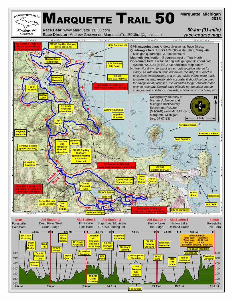
50-km (31-mile) race-course map Race Beta: www.MarquetteTrail50.com Race Director: Andrew Grosvenor, [email protected] Marquette, Michigan 2013 GPS waypoint data: Andrew Grosvenor, Race Director Quadrangle beta: USGS 1:24,000-scale, 1975, Marquette, Michigan quadrangle, 20-foot contours Magnetic declination: 5 degrees west of True North Coordinate beta: Latitude/Longitude geographic coordinate system, WGS 84 (or NAD 83) horizontal map datum Notice: Not drawn to exact scale; route location altered for clarity. As with any human endeavor, this map is subject to omissions, inaccuracies, and errors. While efforts were made to make this map reasonably accurate, it should not be used for navigational purposes. It is intended for general reference only on race day. Consult race officials for the latest course changes, trail conditions, hazards, advisories, corrections, etc. 600' 500' 400' 300' 200' 100' 000' 600' 500' 400' 300' 200' 100' 000' 31.0 mi 25.2 mi 21.7 mi 14.6 mi 10.6 mi 5.0 mi 0.0 mi Aid Station 3—Mile14.6 Sugar Loaf Mountain, Parking Lot Start 0.00 & Finish 31.0 Aid Station 2—Mile 10.6 Forestville Pole Barn Hogback Mountain Top of The World Harlow Lake CR 550 Big Bay Highway (paved crossing & shoulder traverse) Sugarloaf Mountain Little Presque Isle Point Harlow Creek (foot bridge) Lake Superior City of Marquette Presque Isle Park Partridge Island Little Presque Isle Cartography courtesy of Michael A. Neiger and Michigan Backcountry Search and Rescue (MibSAR) www.MibSAR.com, Marquette, Michigan (rev. 07-07-13) N 1 Mile Wetmore Landing CR 550 Big Bay Highway CR 550 Big Bay Highway Aid Station 1 Dead River Steel Grate Bridge Aid Station 2 Forestville Pole Barn Aid Station 4 Harlow Lake 1st Bridge Aid Station 3 Sugar Loaf Mountain CR 550 Parking Lot Start Forestville Pole Barn Finish Forestville Pole Barn Aid Station 5 Harlow Lake Railroad Grade 5.0 mi 5.6 mi 4.0 mi 7.1 mi 3.5 mi 5.8 mi CR 550 Highway Crossing Wetmore Landing RR Track Crossing Junction with Hogback Mountain return loop Sugarloaf Mountain Lake Superior Shoreline Top of The World Powerline Crossing Ore Dock Breakwall MARQUETTE TRAIL 50 Hogback Mountain Rock Quarry Dead River Bridge Dam & Penstock Tube Wooden Bridge Sand Pit Dead River Oxbow Kirby’s Bridge RR Track Crossing Old RR Grade Crossing Lily Pond Footbridge Little Presque Isle Point CR 550 Highway Crossing Harlow Lake Bareback Mountain Old RR Grade Crossroads Start Finish Active Railroad Grade Crossing Dead River Bridge Wooden Bridge Dam & Penstock Tube Sand Pit Kirby’s Bridge Dead River Oxbow Rock Quarry Powerline Crossing Powerline Crossing Forestville Road (gravel crossing) Junction with Hogback Mountain return loop Lily Pond RR Grade Crossing (abandoned) Aid Station 4—Mile 21.7 Harlow Lake Road, 1st Bridge Aid Station 5—Mile 25.2 Harlow Lake Railroad Grade (abandoned) CR 550 Big Bay Highway (paved crossing) Active Railroad Grade Crossing Aid Station 1—Mile 5.0 Dead River, Steel Grate Bridge Wetmore Pond Tourist Park Elevation Beta Total gain: +2692 feet Total loss: -2684 feet Change: +8 feet Elevation above L. Superior Bareback Mountain
Transcript of MARQUETTE TRAIL 50 Marquette, Michigan 2013 -...
50-km (31-mile)race-course map
Race Beta: www.MarquetteTrail50.com
Race Director: Andrew Grosvenor, [email protected]
Marquette, Michigan2013
GPS waypoint data: Andrew Grosvenor, Race Director
Quadrangle beta: USGS 1:24,000-scale, 1975, Marquette,
Michigan quadrangle, 20-foot contours
Magnetic declination: 5 degrees west of True North
Coordinate beta: Latitude/Longitude geographic coordinate
system, WGS 84 (or NAD 83) horizontal map datum
Notice: Not drawn to exact scale; route location altered for
clarity. As with any human endeavor, this map is subject to
omissions, inaccuracies, and errors. While efforts were made
to make this map reasonably accurate, it should not be used
for navigational purposes. It is intended for general reference
only on race day. Consult race officials for the latest course
changes, trail conditions, hazards, advisories, corrections, etc.
600'
500'
400'
300'
200'
100'
000'
600'
500'
400'
300'
200'
100'
000'31.0 mi25.2 mi21.7 mi14.6 mi10.6 mi5.0 mi0.0 mi
Aid Station 3—Mile14.6
Sugar Loaf Mountain, Parking Lot
Start 0.00 & Finish 31.0
Aid Station 2—Mile 10.6
Forestville Pole Barn
Hogback
Mountain
Top of
The World
Harlow
Lake
CR 550 Big Bay
Highway
(paved crossing
& shoulder
traverse)
Sugarloaf
Mountain
Little Presque
Isle Point
Harlow Creek
(foot bridge)
Lake Superior
City of Marquette
Presque Isle Park
Partridge Island
Little Presque Isle
Cartography courtesy of
Michael A. Neiger and
Michigan Backcountry
Search and Rescue
(MibSAR) www.MibSAR.com,
Marquette, Michigan
(rev. 07-07-13)
N
1 Mile
Wetmore Landing
CR 550
Big Bay Highway
CR 550
Big Bay Highway
Aid Station 1
Dead River Steel
Grate Bridge
Aid Station 2
Forestville
Pole Barn
Aid Station 4
Harlow Lake
1st Bridge
Aid Station 3
Sugar Loaf Mountain
CR 550 Parking Lot
Start
Forestville
Pole Barn
Finish
Forestville
Pole Barn
Aid Station 5
Harlow Lake
Railroad Grade
5.0 mi 5.6 mi 4.0 mi 7.1 mi 3.5 mi 5.8 mi
CR 550
Highway
CrossingWetmore
Landing
RR Track
CrossingJunction
with
Hogback
Mountain
return loop
Sugarloaf
Mountain
Lake Superior
Shoreline Top of
The World
Powerline
Crossing
Ore Dock
Breakwall
MARQUETTE TRAIL 50
Hogback Mountain
Rock
Quarry
Dead
River
Bridge
Dam &
Penstock
Tube
Wooden
Bridge
Sand
Pit
Dead
River
Oxbow
Kirby’s
Bridge
RR Track
Crossing
Old RR
Grade
Crossing
Lily
Pond
Footbridge
Little
Presque
Isle
Point
CR 550
Highway
Crossing
Harlow
Lake
Bareback
Mountain
Old
RR
Grade
Crossroads
StartFin
ish
Active Railroad
Grade Crossing Dead
River
Bridge
Wooden Bridge
Dam &
Penstock
Tube
Sand Pit
Kirby’s Bridge
Dead
River
Oxbow
Rock
Quarry
Powerline
Crossing
Powerline
Crossing
Forestville Road
(gravel crossing)
Junction
with
Hogback
Mountain
return loop
Lily
Pond
RR Grade
Crossing
(abandoned)
Aid Station 4—Mile 21.7
Harlow Lake Road, 1st Bridge
Aid Station 5—Mile 25.2
Harlow Lake Railroad
Grade (abandoned)
CR 550 Big Bay Highway
(paved crossing)
Active Railroad
Grade Crossing
Aid Station 1—Mile 5.0
Dead River, Steel Grate Bridge
Wetmore
Pond
Tourist
Park
Elevation BetaTotal gain: +2692 feetTotal loss: -2684 feetChange: +8 feet
Elevation above L. Superior
Bareback
Mountain