Les îles de ciels (« Sky islands...
28
Les îles de ciels (« Sky islands »)
Transcript of Les îles de ciels (« Sky islands...

Les îles de ciels (« Sky islands »)

Qu’est-ce qu’une île de ciel ?
❏
❏
❏
❏
http://wildsonora.com

Localisation : où se trouve les îles de ciel ?
https://sites.oxy.edu/mccormack/McCormack/picks/McCormack_2009_sky_islands_REVIEW.pdfhttp://madrean.org/images/sky-islands-thumb.jpg

→
Madrean Sky Islands

Comment sont-elles formées ?❏
❏
❏
❏
❏
❏
http://www.solpass.org/6ss/Images/NorthAmericanRegionlabel435x438.gif

Géologie❏
❏
❏
❏
❏
❏
Simone Dumas (2017), Notes de cours HIver 2017 - Déformation.
https://geology.com/rocks/pictures/welded-tuff.jpg

Hydrologie des “Sky islands”
❏
❏
❏
❏
https://toolkit.climate.gov/sites/default/files/styles/large/public/Warming_Drying_SkyIslands.jpg?itok=EneMWBvJ

❏
❏
❏
Arroyos
https://upload.wikimedia.org/wikipedia/commons/thumb/5/5d/Sonoran_Desert_Arroyo_Sahuarita_Arizona_2013.jpg/1200px-Sonoran_Desert_Arroyo_Sahuarita_Arizona_2013.jpg
https://upload.wikimedia.org/wikipedia/commons/thumb/3/32/GobiFlood.JPG/1200px-GobiFlood.JPG

Zones de végétation en fonction de l’altitude
❏
❏
❏
❏
❏
❏
http://www.rickbrusca.com/http___www.rickbrusca.com_index.html/The_Sky_Islands_files/SkyIslandBiomesFigF_6-10-13.png
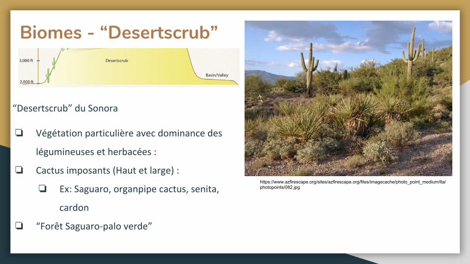
Biomes - “Desertscrub”
❏
❏
❏
❏
https://www.azfirescape.org/sites/azfirescape.org/files/imagecache/photo_point_medium/lta/photopoints/082.jpg

Biomes - “Desert Grassland”
❏
❏
❏
❏
http___www.rickbrusca.com_index.html/The_Sky_Islands_files/Desert%20Grassland,%20Molino%20Basin,%20AZ%20Trail.jpg
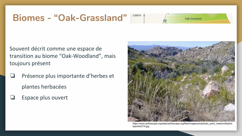
Biomes - “Oak-Grassland”
❏
❏
https://www.azfirescape.org/sites/azfirescape.org/files/imagecache/photo_point_medium/lta/photopoints/214.jpg

Biomes - “Oak-Woodland”
❏
https://www.azfirescape.org/sites/azfirescape.org/files/dsc01211.jpg

Biomes - Chaparral
❏
❏
https://cals.arizona.edu/yavapai/graphics/azintchaparral.jpg
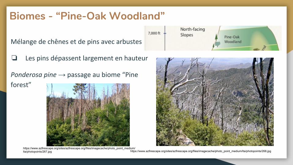
Biomes - “Pine-Oak Woodland”
❏
→
https://www.azfirescape.org/sites/azfirescape.org/files/imagecache/photo_point_medium/lta/photopoints/268.jpghttps://www.azfirescape.org/sites/azfirescape.org/files/imagecache/photo_point_medium/lta/photopoints/267.jpg
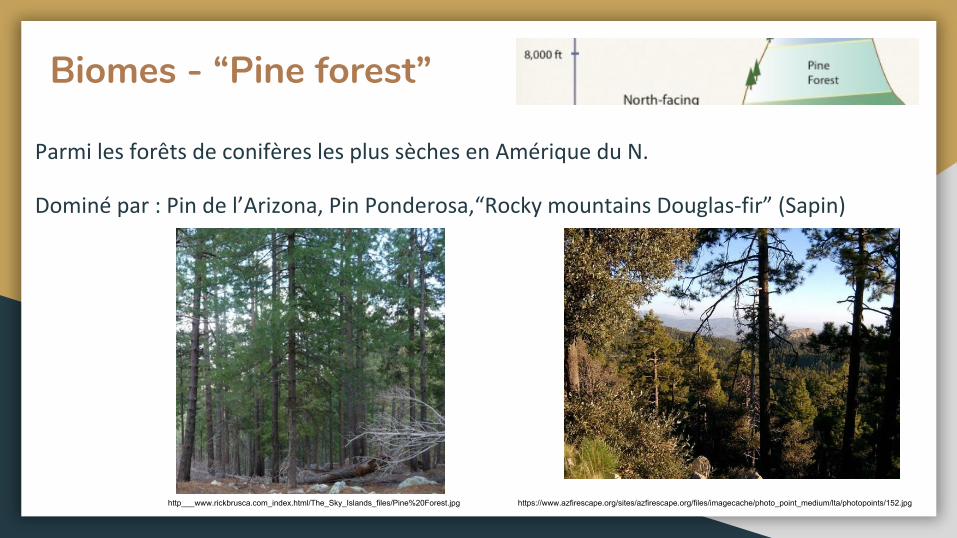
Biomes - “Pine forest”
https://www.azfirescape.org/sites/azfirescape.org/files/imagecache/photo_point_medium/lta/photopoints/152.jpghttp___www.rickbrusca.com_index.html/The_Sky_Islands_files/Pine%20Forest.jpg
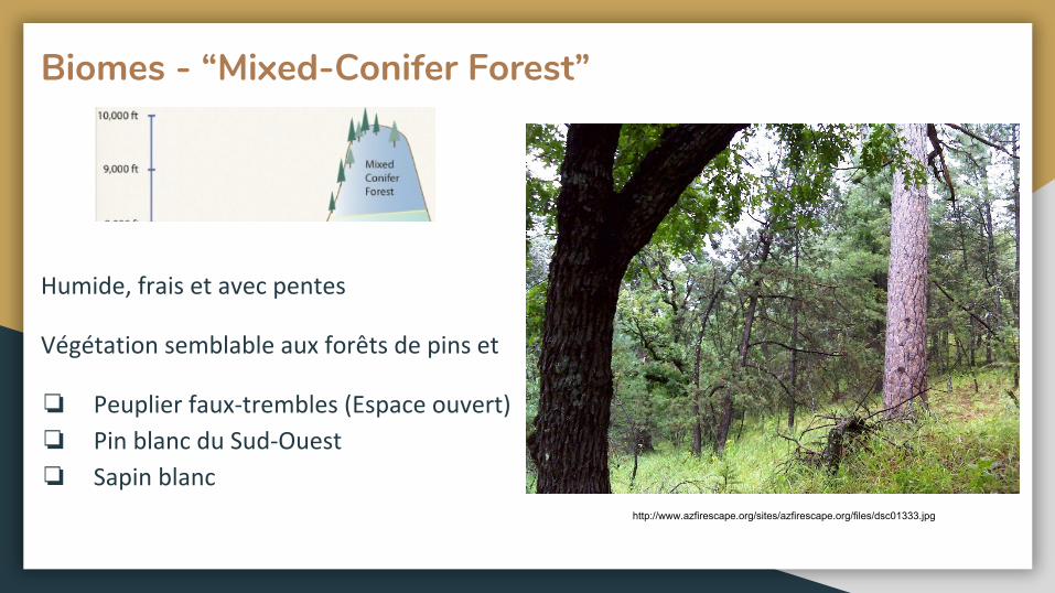
Biomes - “Mixed-Conifer Forest”
❏
❏
❏
http://www.azfirescape.org/sites/azfirescape.org/files/dsc01333.jpg
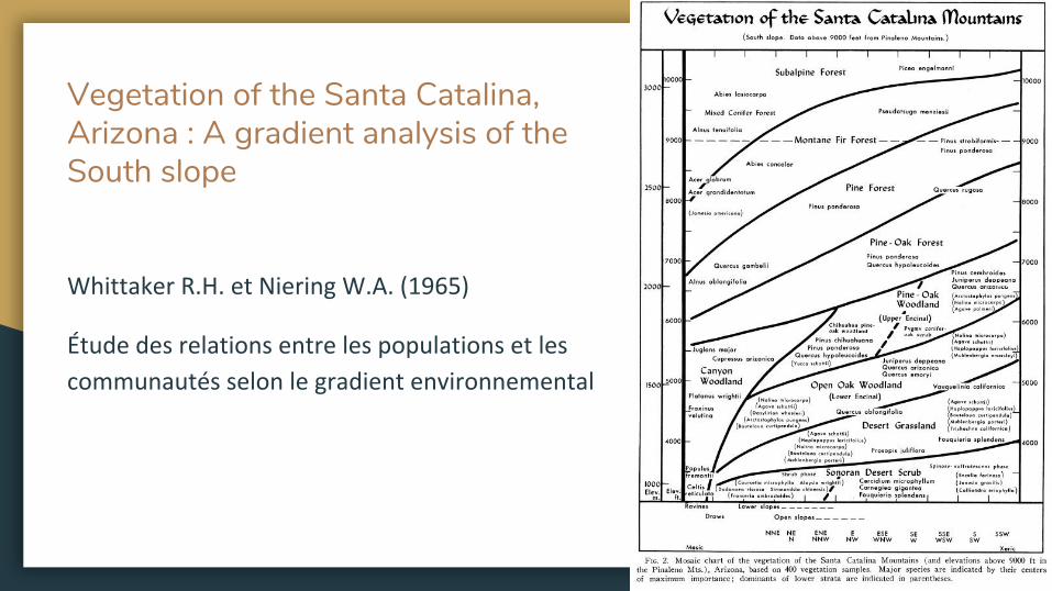
Vegetation of the Santa Catalina, Arizona : A gradient analysis of the South slope

Biodiversité et Biogéographie
❏
❏
❏
❏
❏
❏
Sources des images: https://www.gannett-cdn.com/-mm-/0c1b3b666dec79bbdaec3cac85dd7767f36e0297/c=0-47-1953-1515&r=x404&c=534x401/local/-/media/2016/06/21/Phoenix/Phoenix/636021285636519811-bighorn.jpghttp://www.ejphoto.com/images_AZ/AZ_PrairieDog01.jpghttp://www.saguaro-juniper.com/i_and_i/mammals/javelina/06-11_5886.jpg
Gabriel Blouin-Demers, (2018). Notes de cours BIO3503 - Écologie des déserts - Reptiles (11)
Sceloporus jarrovi


❏
❏
❏ ⅔

Migration et corridors
❏
https://upload.wikimedia.org/wikipedia/commons/7/76/Gilarivermap.pnghttps://upload.wikimedia.org/wikipedia/commons/2/28/Ocelot.jpg

Impacts des changements climatiques
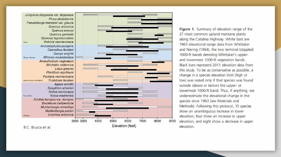
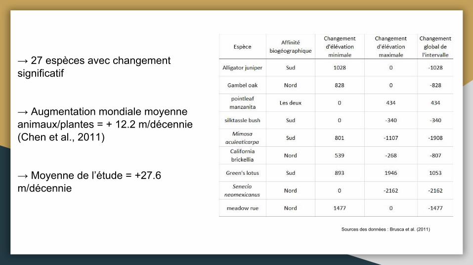
→ 27 espèces avec changement significatif
→ Augmentation mondiale moyenne animaux/plantes = + 12.2 m/décennie (Chen et al., 2011)
→ Moyenne de l’étude = +27.6 m/décennie
Sources des données : Brusca et al. (2011)

Impacts des changements climatiques
❏
❏❏

https://tucsonherpsociety.org/wp-content/uploads/2013/09/Bunchgrass-lizard-Huachuca-Mtns-AZ2-D41-1024x745.jpg

Références:
Baker M.B. Jr., DeBano L.F., Ffolliott F., (1994). Hydrology and Watershed Management in the Madrean Archipelago. Biodiversity and Management of the Madrean Archipelago: The Sky Islands of Southwestern United States and Northwestern Mexico. USDA Forest service. pp: 329-337
Brusca R.C., Wiens J., Meyer W.M., Eble J., Franklin K., Overpeck J.T., Moore W. (2013). Dramatic response to climate change in the Southwest: Robert Whittaker’s 1963 Arizona Mountain plant transect revisited. Ecology and Evolution. Vol. 3(10), pp: 3307-3319.
Coe S.J., Finch D.M., Friggens M.M., (2012). An assessment of climate change and the vulnerability of wildlife in the Sky Islands of the Southwest. Gen. Tech. Rep. RMRS-GTR-273. Fort Collins, CO: U.S. Department of Agriculture, Forest Service, Rocky Mountain Research Station. 208p.
Hendrixson B.E., Guice A.V., Bond J.E. (2015). Integrative species delimitation and conservation of tarantulas (Araneae, Mygalomorphae, Theraphosidae) from a North American Biodiversity hotspot. Insect conservation and Diversity. Vol. 8, pp: 120-131
P. McLaughlin, Steven. (1994). An Overview of the Flora of the Sky Islands, Southeastern Arizona: Diversity, Affinities, and Insularity. Ldv Forum - LDV.
Ober K.A., Connolly C.T. (2015). Geometric morphometric and phylogenetic analyses of Arizona Sky Island populations of Scaphinotus peteris Roeschke (Coleoptera: Carabidae). Zoological Journal of the Linnean Society. Vol.175, pp: 107-118.
Whittaker R.H., Niering W.A. (1965). Vegation of the Santa Catalina Mountains, Arizona: A gradient analysis of South slope. Ecology. Vol. 46, No. 4, pp: 429-452.
Sitographie:
https://www.fs.fed.us/wildflowers/beauty/Sky_Islands/index.shtml
https://www.terrain.org/articles/21/skroch.htm
https://en.wikipedia.org/wiki/Arroyo_(creek)
https://serc.carleton.edu/vignettes/collection/36633.html
https://geochange.er.usgs.gov/sw/impacts/geology/arroyos/
https://www.sonorandesert.org/learning-more/wildlife-linkages-2/oracle-road-wildlife-crossings-2/
https://www.skyislandalliance.org/wp-content/uploads/2014/11/10-Fall-Corridors.pdf
http://www.rickbrusca.com/
http://www.madrean.org/symbfauna/
https://www.azfirescape.org/catalina/landscape_types