L'analyse de données matricielles dans une base de données ... · L'analyse de données...
26
L'analyse de données matricielles dans une base de données géospatiale: L'approche PostGIS Raster Boreal Avian Modelling Project Pierre Racine Professionnel de recherche Professionnel de recherche Centre d’étude de la forêt Département des sciences du bois et de la forêt Université Laval Centre d’information topographique Ressources naturelles Canada Sherbrooke - Janvier 2011
Transcript of L'analyse de données matricielles dans une base de données ... · L'analyse de données...
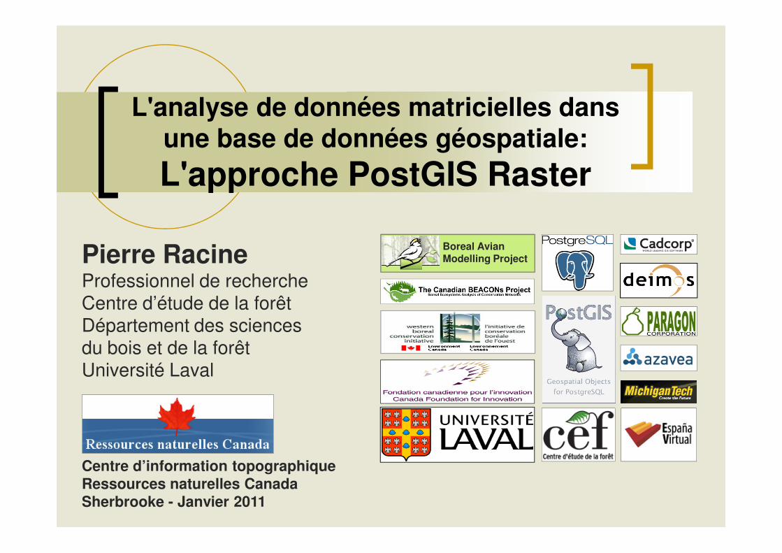
L'analyse de données matricielles dans une base de données géospatiale: L'approche PostGIS Raster
Boreal AvianModelling ProjectPierre Racine
Professionnel de rechercheProfessionnel de rechercheCentre d’étude de la forêtDépartement des sciences du bois et de la forêtUniversité Laval
Centre d’information topographiqueRessources naturelles Canada Sherbrooke - Janvier 2011
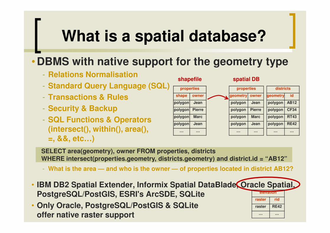
What is a spatial database?• DBMS with native support for the geometry type
- Relations Normalisation- Standard Query Language (SQL)- Transactions & Rules- Security & Backup - SQL Functions & Operators
properties
shape owner
polygon Jean
polygon Pierre
polygon Marc
properties
geometry owner
polygon Jean
polygon Pierre
polygon Marc
shapefile spatial DB
districts
geometry id
polygon AB12
polygon CF34
polygon RT43- SQL Functions & Operators (intersect(), within(), area(), =, &&, etc…)
- What is the area — and who is the owner — of properties located in district AB12?
• IBM DB2 Spatial Extender, Informix Spatial DataBlade, Oracle Spatial, PostgreSQL/PostGIS, ESRI's ArcSDE, SQLite
• Only Oracle, PostgreSQL/PostGIS & SQLiteoffer native raster support
polygon Marc
polygon Jean
… …
polygon Marc
polygon Jean
… …
SELECT area(geometry), owner FROM properties, districts WHERE intersect(properties.geometry, districts.geometry) and district.id = “AB12”
polygon RT43
polygon RE42
… …
elevation
raster rid
raster RE42
… …
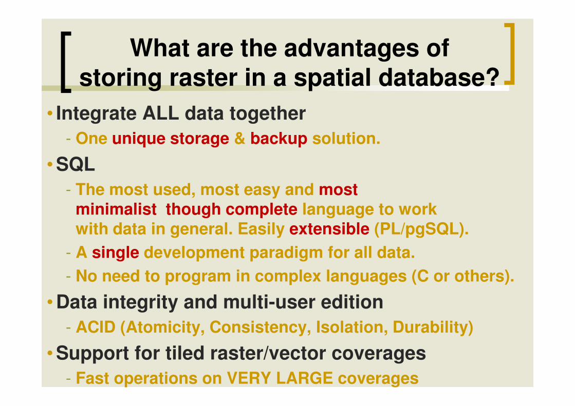
What are the advantages of storing raster in a spatial database?
• Integrate ALL data together- One unique storage & backup solution.
• SQL- The most used, most easy and most
minimalist though complete language to work minimalist though complete language to work with data in general. Easily extensible (PL/pgSQL).
- A single development paradigm for all data.- No need to program in complex languages (C or others).
• Data integrity and multi-user edition- ACID (Atomicity, Consistency, Isolation, Durability)
• Support for tiled raster/vector coverages- Fast operations on VERY LARGE coverages

Introducing PostGIS Raster
• Support for rasters in the PostGIS spatial database- RASTER is a new native base type like the PostGIS GEOMETRY type- Implemented very much like and as easy to use as the GEOMETRY
type� One row = one raster� One table = one coverage
- Integrated as much as possible with the GEOMETRY type- Integrated as much as possible with the GEOMETRY type� SQL API easy to learn for usual PostGIS users� Full raster/vector analysis capacity taking nodata value into account.� Seamless when possible.
- First release with future PostGIS 2.0• Development Team
- Current: Jorge Arevalo, Pierre Racine, Mateusz Loskot, Regina & Leo Obe
- Past: Sandro Santilli, David Zwarg• Funding
- Steve Cumming through a Canada Foundation for Innovation grant- Deimos Space, Cadcorp, Michigan Tech Research Institute, Azavea, OSGeo
Chapter 13 on PostGIS Raster
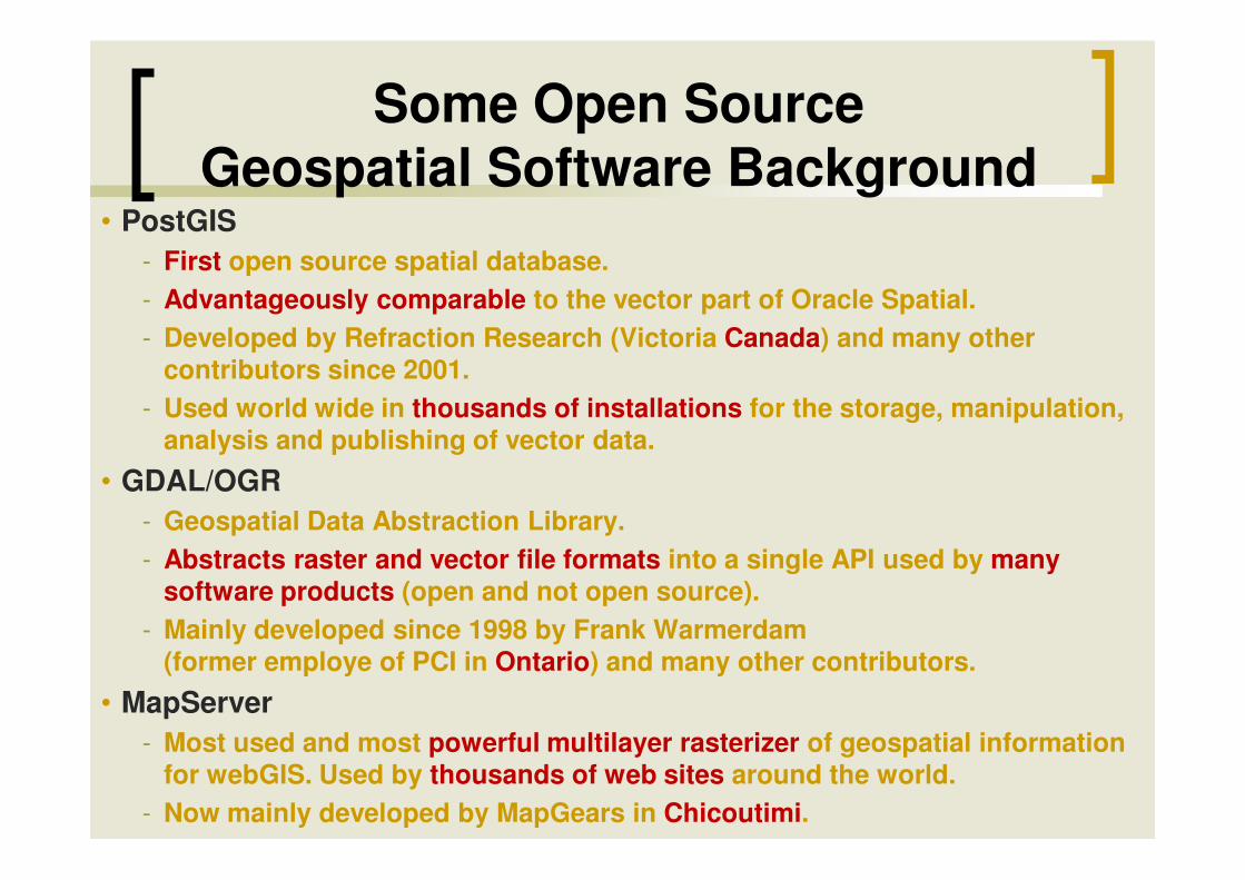
Some Open Source Geospatial Software Background
• PostGIS- First open source spatial database.- Advantageously comparable to the vector part of Oracle Spatial.- Developed by Refraction Research (Victoria Canada) and many other
contributors since 2001.- Used world wide in thousands of installations for the storage, manipulation,
analysis and publishing of vector data.analysis and publishing of vector data.
• GDAL/OGR- Geospatial Data Abstraction Library.- Abstracts raster and vector file formats into a single API used by many
software products (open and not open source).- Mainly developed since 1998 by Frank Warmerdam
(former employe of PCI in Ontario) and many other contributors.
• MapServer- Most used and most powerful multilayer rasterizer of geospatial information
for webGIS. Used by thousands of web sites around the world.- Now mainly developed by MapGears in Chicoutimi.
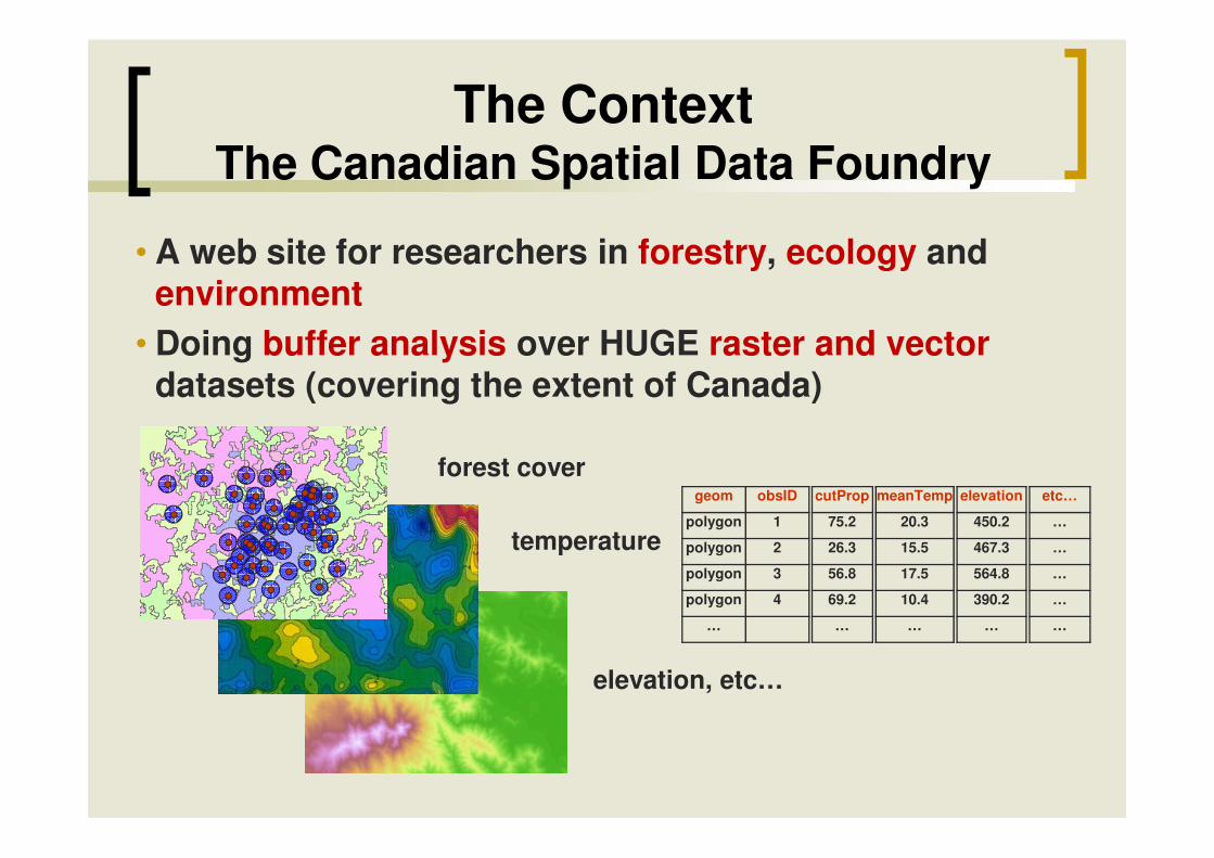
• A web site for researchers in forestry, ecology and environment
• Doing buffer analysis over HUGE raster and vector datasets (covering the extent of Canada)
The ContextThe Canadian Spatial Data Foundry
elevation, etc…
temperature
forest covergeom obsID
polygon 1
polygon 2
polygon 3
polygon 4
…
meanTemp
20.3
15.5
17.5
10.4
…
elevation
450.2
467.3
564.8
390.2
…
etc…
…
…
…
…
…
cutProp
75.2
26.3
56.8
69.2
…

Strategies for Implementing theBase Buffering Process
We need code for…
• vector storage & manipulation
StrategyA
database
Bdatabase
Cdatabase
Strategy C (implementing raster as a native type into PostGIS) is a more elegant and generic solution
answering many more GIS problems
• raster storage & manipulation
• analysis processes
outsidedatabase
specifichomemade application
database(non-native
support)
specifichomemade application
database(native support)
database
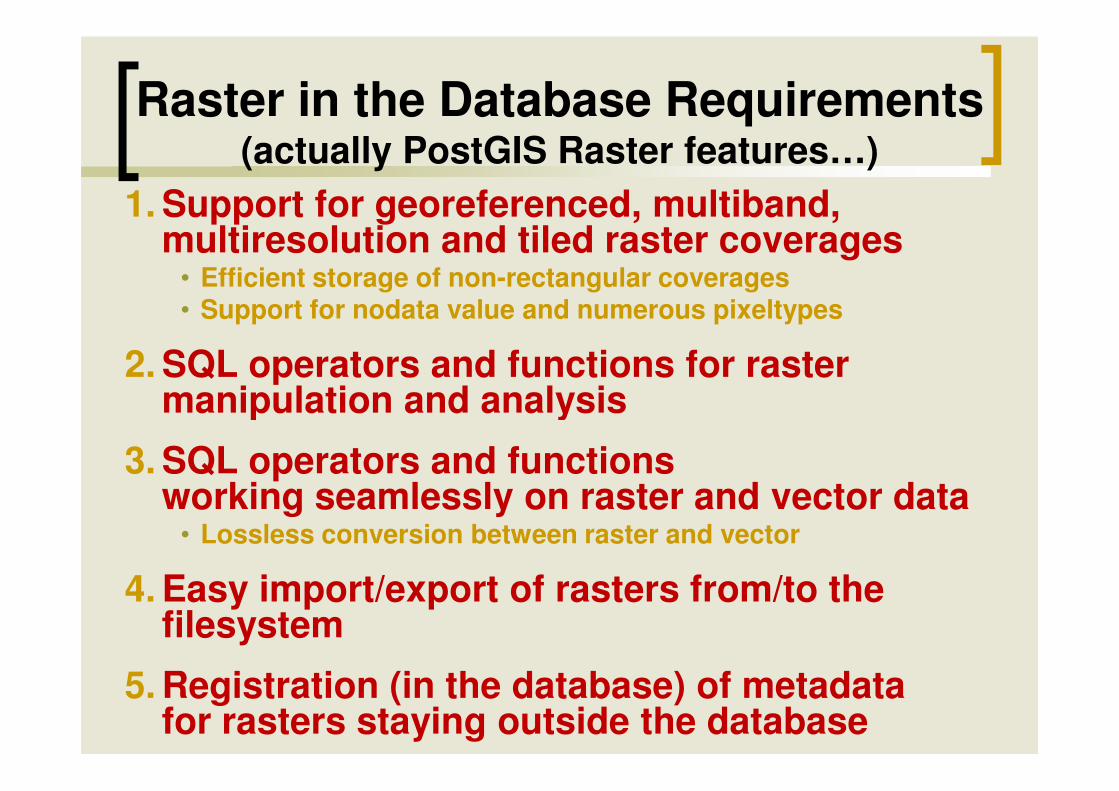
Raster in the Database Requirements(actually PostGIS Raster features…)
1. Support for georeferenced, multiband, multiresolution and tiled raster coverages
• Efficient storage of non-rectangular coverages• Support for nodata value and numerous pixeltypes
2. SQL operators and functions for raster manipulation and analysismanipulation and analysis
3. SQL operators and functions working seamlessly on raster and vector data
• Lossless conversion between raster and vector
4. Easy import/export of rasters from/to the filesystem
5. Registration (in the database) of metadata for rasters staying outside the database
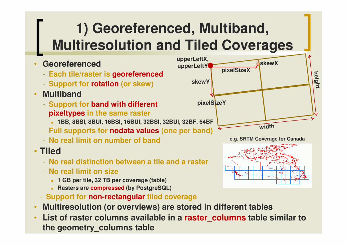
• Georeferenced- Each tile/raster is georeferenced- Support for rotation (or skew)
• Multiband- Support for band with different
pixeltypes in the same raster� 1BB, 8BSI, 8BUI, 16BSI, 16BUI, 32BSI, 32BUI, 32BF, 64BF
1) Georeferenced, Multiband, Multiresolution and Tiled Coverages
upperLeftX, upperLeftY
pixelSizeX
pixelSizeY
skewX
skewY
� 1BB, 8BSI, 8BUI, 16BSI, 16BUI, 32BSI, 32BUI, 32BF, 64BF
- Full supports for nodata values (one per band)- No real limit on number of band
• Tiled - No real distinction between a tile and a raster- No real limit on size
� 1 GB per tile, 32 TB per coverage (table)� Rasters are compressed (by PostgreSQL)
- Support for non-rectangular tiled coverage• Multiresolution (or overviews) are stored in different tables• List of raster columns available in a raster_columns table similar to
the geometry_columns table
e.g. SRTM Coverage for Canada
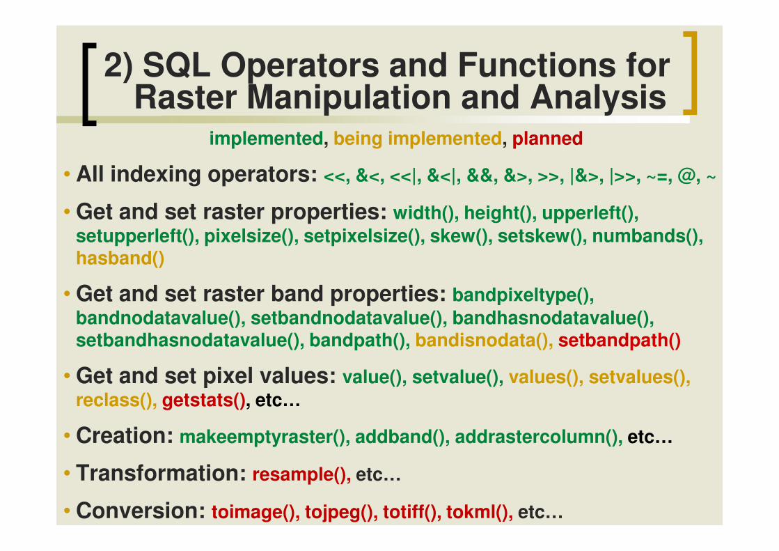
2) SQL Operators and Functions for Raster Manipulation and Analysis
implemented, being implemented, planned
• All indexing operators: <<, &<, <<|, &<|, &&, &>, >>, |&>, |>>, ~=, @, ~
• Get and set raster properties: width(), height(), upperleft(), setupperleft(), pixelsize(), setpixelsize(), skew(), setskew(), numbands(), hasband()
• Get and set raster band properties: bandpixeltype(), bandnodatavalue(), setbandnodatavalue(), bandhasnodatavalue(), setbandhasnodatavalue(), bandpath(), bandisnodata(), setbandpath()
• Get and set pixel values: value(), setvalue(), values(), setvalues(), reclass(), getstats(), etc…
• Creation: makeemptyraster(), addband(), addrastercolumn(), etc…
• Transformation: resample(), etc…
• Conversion: toimage(), tojpeg(), totiff(), tokml(), etc…
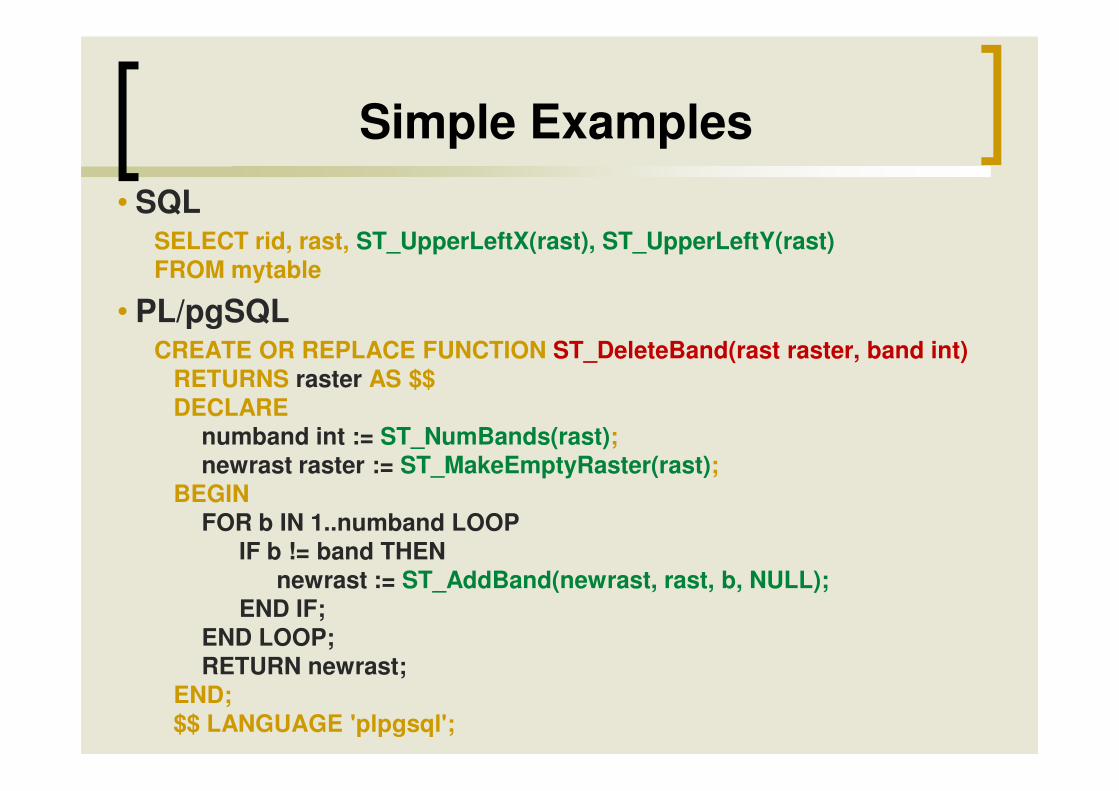
Simple Examples• SQL
SELECT rid, rast, ST_UpperLeftX(rast), ST_UpperLeftY(rast) FROM mytable
• PL/pgSQLCREATE OR REPLACE FUNCTION ST_DeleteBand(rast raster, band int)
RETURNS raster AS $$DECLAREDECLARE
numband int := ST_NumBands(rast);newrast raster := ST_MakeEmptyRaster(rast);
BEGINFOR b IN 1..numband LOOP
IF b != band THENnewrast := ST_AddBand(newrast, rast, b, NULL);
END IF;END LOOP;RETURN newrast;
END;$$ LANGUAGE 'plpgsql';

3) SQL Operators and Functions Working Seamlessly on Raster and Vector
The time is past when we wanted to work on raster data differently than on vector data!
We just want to work on COVERAGES!(in whatever format they are: vector, raster, TIN, point cloud, etc…)
• Seamless raster versions of existing geometry functions: srid(), setsrid(), convexhull(), envelope(), isempty(), union(), area(), is valid(), setsrid(), convexhull(), envelope(), isempty(), union(), area(), is valid(), centroid(), transform(), rotate(), scale(), translate(), etc…
• Easy raster to vector conversion functions: dumpaspolygons(), polygon(), pixelaspolygon(), pixelaspolygons(), etc…
• Easy vector to raster conversion functions: asraster(), toraster(),interpolate(), etc…
• Major vector-like analysis functions working with rasters: intersection(), intersects(), within(), contains(), overlaps(), etc…
• Major raster-like analysis functions working with vectors: mapalgebra(), clip(), etc…
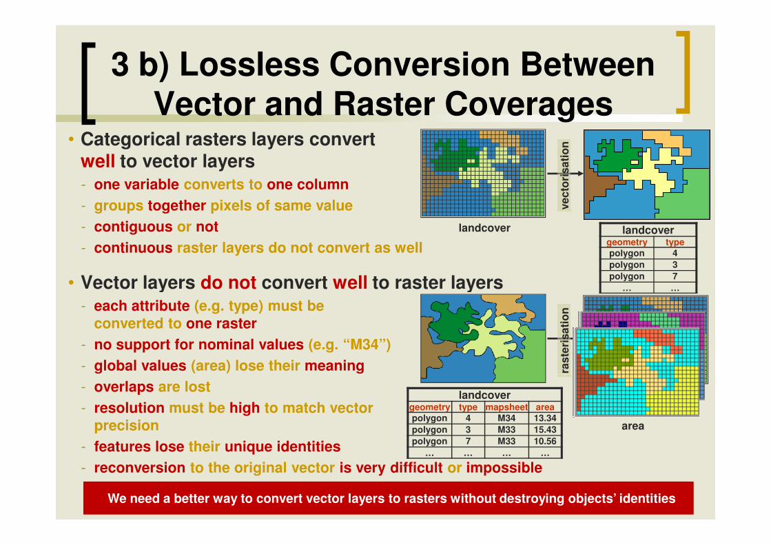
• Categorical rasters layers convert well to vector layers- one variable converts to one column- groups together pixels of same value- contiguous or not- continuous raster layers do not convert as well
• Vector layers do not convert well to raster layers
3 b) Lossless Conversion Between Vector and Raster Coverages
vect
oris
atio
n
landcovergeometry typepolygon 4polygon 3polygon 7
landcover
landcover
• Vector layers do not convert well to raster layers- each attribute (e.g. type) must be
converted to one raster- no support for nominal values (e.g. “M34”)- global values (area) lose their meaning- overlaps are lost- resolution must be high to match vector
precision- features lose their unique identities- reconversion to the original vector is very difficult or impossible
rast
eris
atio
n
polygon 7… …
landcovergeometry type mapsheet areapolygon 4 M34 13.34polygon 3 M33 15.43polygon 7 M33 10.56
… … … …
mapsheetarea
We need a better way to convert vector layers to rasters without destroying objects’ identities

• In a vector layer, each object has its own identitylandcover
geometry type mapsheet areapolygon 4 M34 13.34polygon 3 M33 15.43polygon 7 M33 10.56polygon 9 M34 24.54polygon 5 M33 23.43polygon 2 M32 12.34
… … … …
3 b) Lossless Conversion Between Vector and Raster Layers
• In a raster layer converted from a vector layer, each object should also conserve its own identity
- Each “raster object” has its own georeference- Black pixels are “nodata values”- Like vectors, raster objects may or may not overlap- Raster algorithms can be used on the whole layer after a “blend” of the objects into a single raster
landcoverraster type mapsheet arearaster 4 M34 13.34raster 3 M33 15.43raster 7 M33 10.56raster 9 M34 24.54raster 5 M33 23.43raster 2 M32 12.34
… … … …
Rasters become just another way to store geographic features in a more expressive
vector object-oriented-like style

• The goal is to be able to do overlay operation on coverages the same way we are used to do them on vector coverage but without worrying if data are stored in vector format or raster format.
ST_Intersection (implemented)
covergeom ctype
polygon 4polygon 3polygon 5polygon 2
observationgeom obsidpoint 24point 31point 45
… …
resultgeom obsid ctype
polygon 24 4polygon 53 3polygon 24 5polygon 23 2
∩∩∩∩ �
area10.3411.2314.239.45
observgeom obsid
polygon 24polygon 31polygon 45
… …
coverraster ctyperaster 4raster 3raster 5raster 2
- ST_Intersects takes nodata value into account. - Great simplification of applications concepts and graphical user interfaces- See the tutorial on the PostGIS Raster wiki…
polygon 2… …
… … polygon 23 2… … …
SELECT ST_Intersection(ST_Buffer(observ.geom, 1000), cover.geom) as geom, obsid, ctypeFROM observation, coverWHERE ST_Intersects(ST_Buffer(observation.geom, 1000), cover.geom)
9.45…
SELECT obsid, geom, ctype, ST_Area( geom ) as area FROM (
) foo
… … raster 2… …
(gv).geom, (gv).val, (gv).geomgv,
, ctyperast
rast
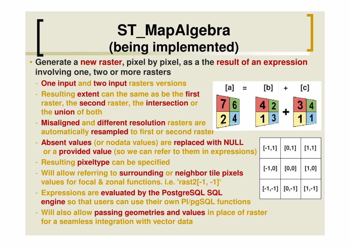
ST_MapAlgebra (being implemented)
• Generate a new raster, pixel by pixel, as a the result of an expressioninvolving one, two or more rasters - One input and two input rasters versions- Resulting extent can the same as be the first
raster, the second raster, the intersection or the union of both
- Misaligned and different resolution rasters are
[a] = [b] + [c]
- Misaligned and different resolution rasters are automatically resampled to first or second raster
- Absent values (or nodata values) are replaced with NULLor a provided value (so we can refer to them in expressions)
- Resulting pixeltype can be specified- Will allow referring to surrounding or neighbor tile pixels
values for focal & zonal functions. i.e. 'rast2[-1, -1]‘- Expressions are evaluated by the PostgreSQL SQL
engine so that users can use their own Pl/pgSQL functions- Will also allow passing geometries and values in place of raster
for a seamless integration with vector data
[-1,1]
[-1,0]
[-1,-1]
[0,1]
[0,0]
[0,-1]
[1,1]
[1,0]
[1,-1]

ST_MapAlgebra(being implemented)
• Example 1: Reclassifying pixel values (one raster version)- SELECT ST_MapAlgebra(rast, 'CASE WHEN rast < 0 THEN 0
ELSE rast END')
FROM elevation
• Example 2: Computing the mean + some personnal adjustment (two
-4
-1
-2
2
-4
0
0
2
1
0
0
0
2
0
0
0
2
1
• Example 2: Computing the mean + some personnal adjustment (two rasters version)
- SELECT ST_MapAlgebra(elev1.rast, elev2.rast, 'rast1 + rast2) / 2 + MyAdjustment(rast1, rast2)', '32BF', 'INTERSECTION') FROM elev1, elev2 WHERE ST_Intersects(elev1.rast, elev2.rast)
• You can also intersect or mergerasters, create raster aggregates, and many funny things!
-4
-1
-2
2
-4
0
0
2
1
-10
-2
-5
0
-12
-2
0
2
1
0
-4.5
-6
0
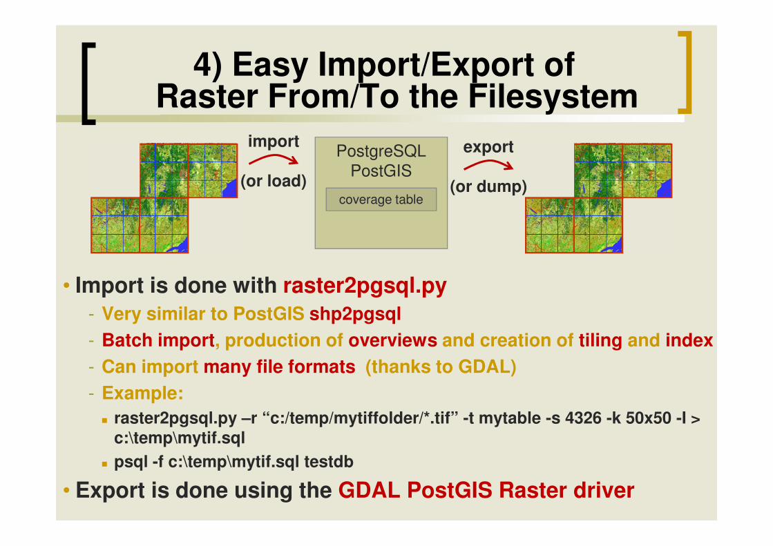
4) Easy Import/Export of Raster From/To the Filesystem
PostgreSQLPostGIS
coverage table
import
(or load)
export
(or dump)
• Import is done with raster2pgsql.py• Import is done with raster2pgsql.py- Very similar to PostGIS shp2pgsql- Batch import, production of overviews and creation of tiling and index- Can import many file formats (thanks to GDAL)- Example:
� raster2pgsql.py –r “c:/temp/mytiffolder/*.tif” -t mytable -s 4326 -k 50x50 -I > c:\temp\mytif.sql
� psql -f c:\temp\mytif.sql testdb
• Export is done using the GDAL PostGIS Raster driver
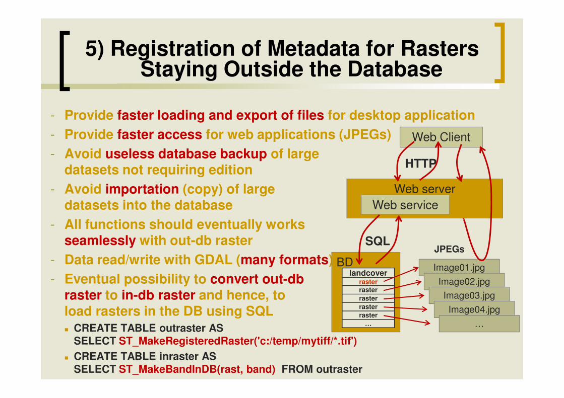
5) Registration of Metadata for Rasters Staying Outside the Database
- Provide faster loading and export of files for desktop application- Provide faster access for web applications (JPEGs)- Avoid useless database backup of large
datasets not requiring edition- Avoid importation (copy) of large
datasets into the database
Web Client
Web serverWeb service
HTTP
datasets into the database- All functions should eventually works
seamlessly with out-db raster- Data read/write with GDAL (many formats)- Eventual possibility to convert out-db
raster to in-db raster and hence, toload rasters in the DB using SQL� CREATE TABLE outraster AS
SELECT ST_MakeRegisteredRaster('c:/temp/mytiff/*.tif') � CREATE TABLE inraster AS
SELECT ST_MakeBandInDB(rast, band) FROM outraster
BDlandcover
rasterrasterrasterrasterraster
…
Web service
SQL
Image01.jpg
JPEGs
Image02.jpgImage03.jpgImage04.jpg
…
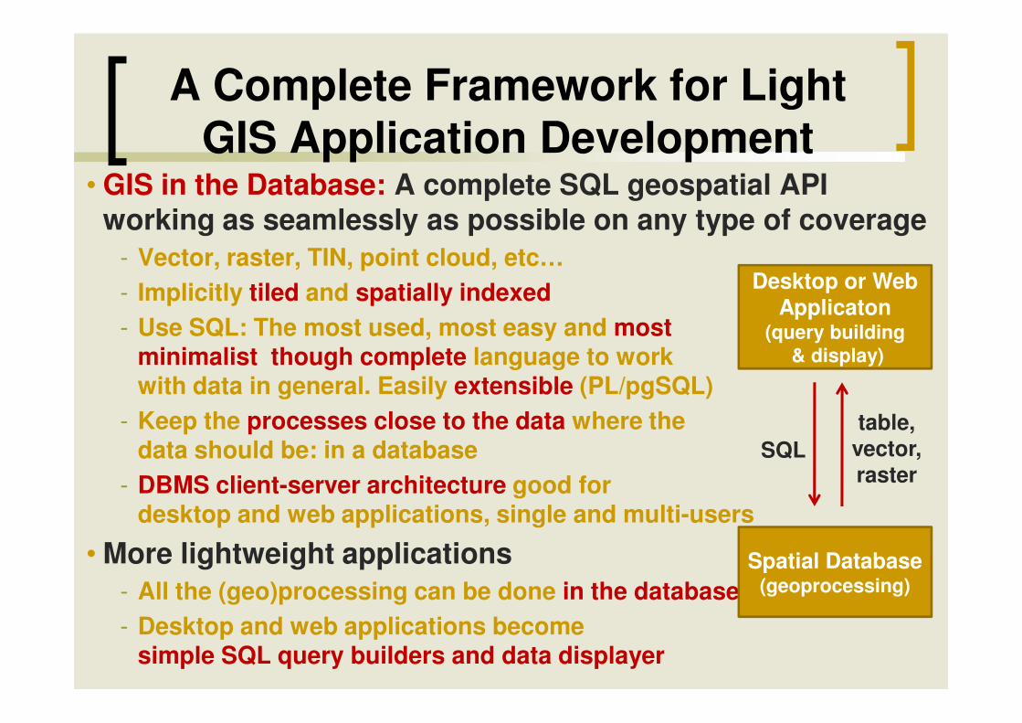
A Complete Framework for Light GIS Application Development
• GIS in the Database: A complete SQL geospatial API working as seamlessly as possible on any type of coverage
- Vector, raster, TIN, point cloud, etc…- Implicitly tiled and spatially indexed- Use SQL: The most used, most easy and most
minimalist though complete language to work
Desktop or Web Applicaton
(query building& display)minimalist though complete language to work
with data in general. Easily extensible (PL/pgSQL)- Keep the processes close to the data where the
data should be: in a database- DBMS client-server architecture good for
desktop and web applications, single and multi-users
• More lightweight applications- All the (geo)processing can be done in the database- Desktop and web applications become
simple SQL query builders and data displayer
& display)
Spatial Database(geoprocessing)
SQLtable,
vector,raster
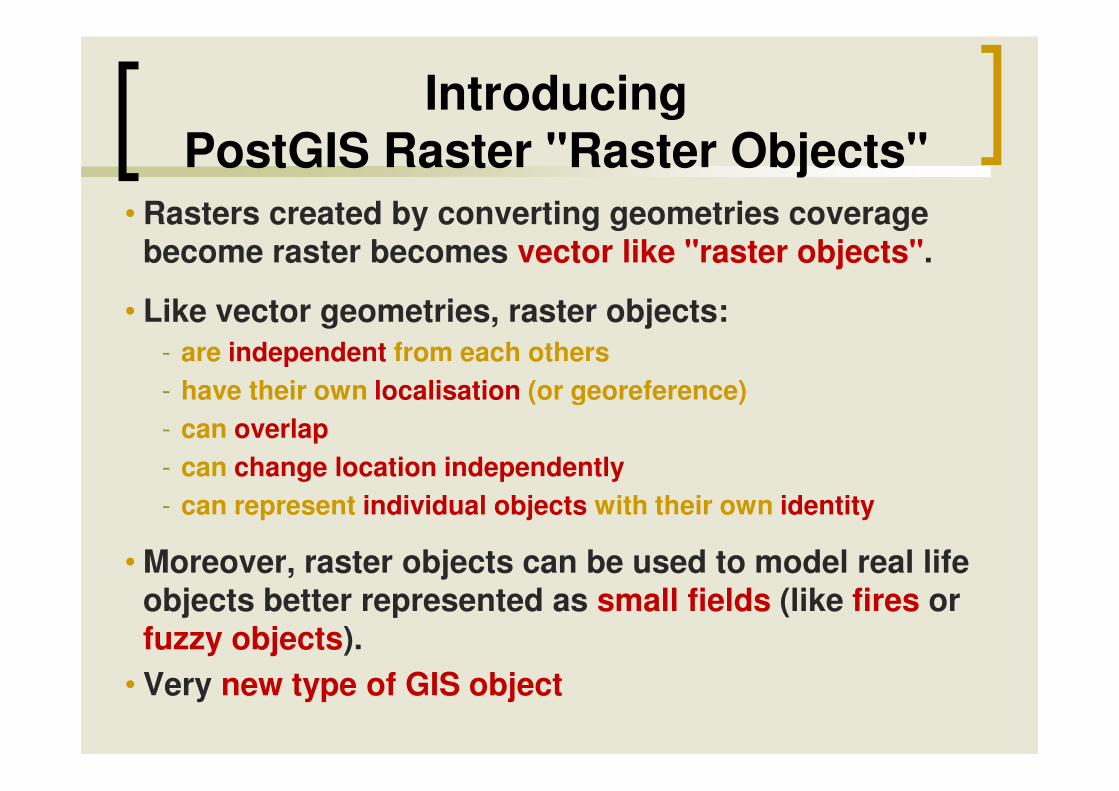
Introducing PostGIS Raster "Raster Objects"
• Rasters created by converting geometries coverage become raster becomes vector like "raster objects".
• Like vector geometries, raster objects:- are independent from each others- have their own localisation (or georeference)- have their own localisation (or georeference)- can overlap- can change location independently- can represent individual objects with their own identity
• Moreover, raster objects can be used to model real life objects better represented as small fields (like fires or fuzzy objects).
• Very new type of GIS object
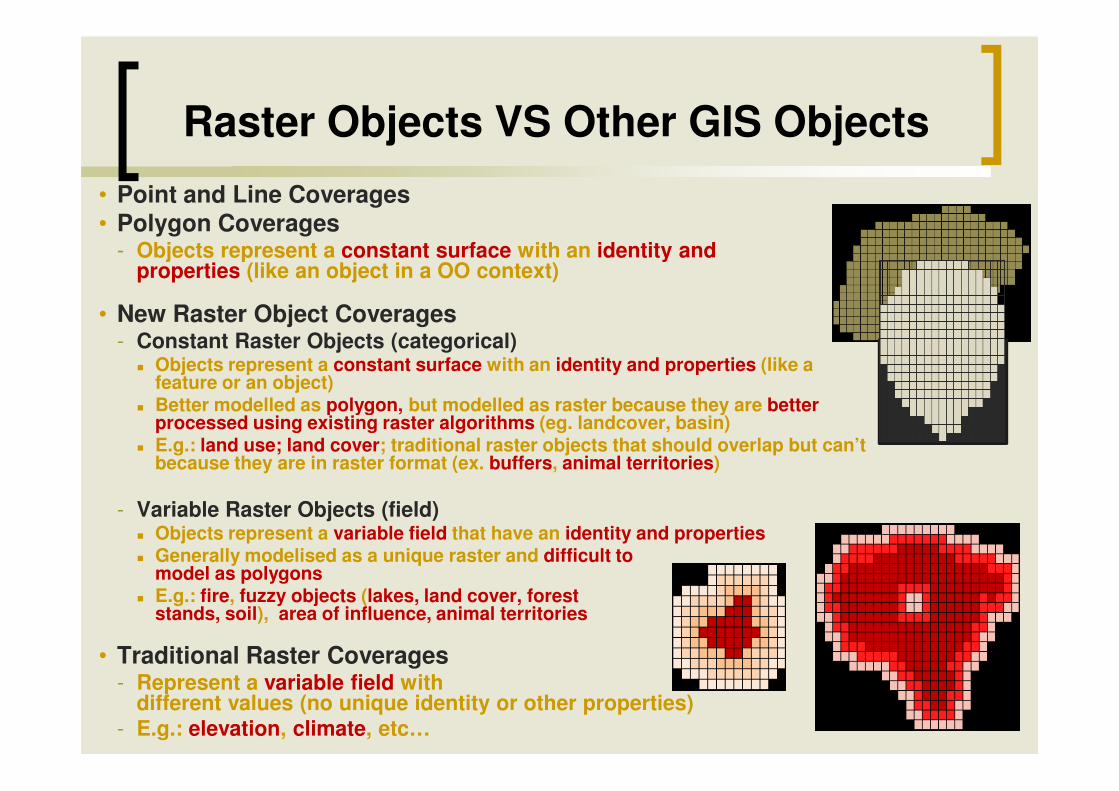
Raster Objects VS Other GIS Objects• Point and Line Coverages• Polygon Coverages
- Objects represent a constant surface with an identity and properties (like an object in a OO context)
• New Raster Object Coverages- Constant Raster Objects (categorical)
� Objects represent a constant surface with an identity and properties (like a feature or an object)Better modelled as polygon, but modelled as raster because they are better � Better modelled as polygon, but modelled as raster because they are better processed using existing raster algorithms (eg. landcover, basin)
� E.g.: land use; land cover; traditional raster objects that should overlap but can’t because they are in raster format (ex. buffers, animal territories)
- Variable Raster Objects (field)� Objects represent a variable field that have an identity and properties� Generally modelised as a unique raster and difficult to
model as polygons� E.g.: fire, fuzzy objects (lakes, land cover, forest
stands, soil), area of influence, animal territories
• Traditional Raster Coverages- Represent a variable field with
different values (no unique identity or other properties)- E.g.: elevation, climate, etc…
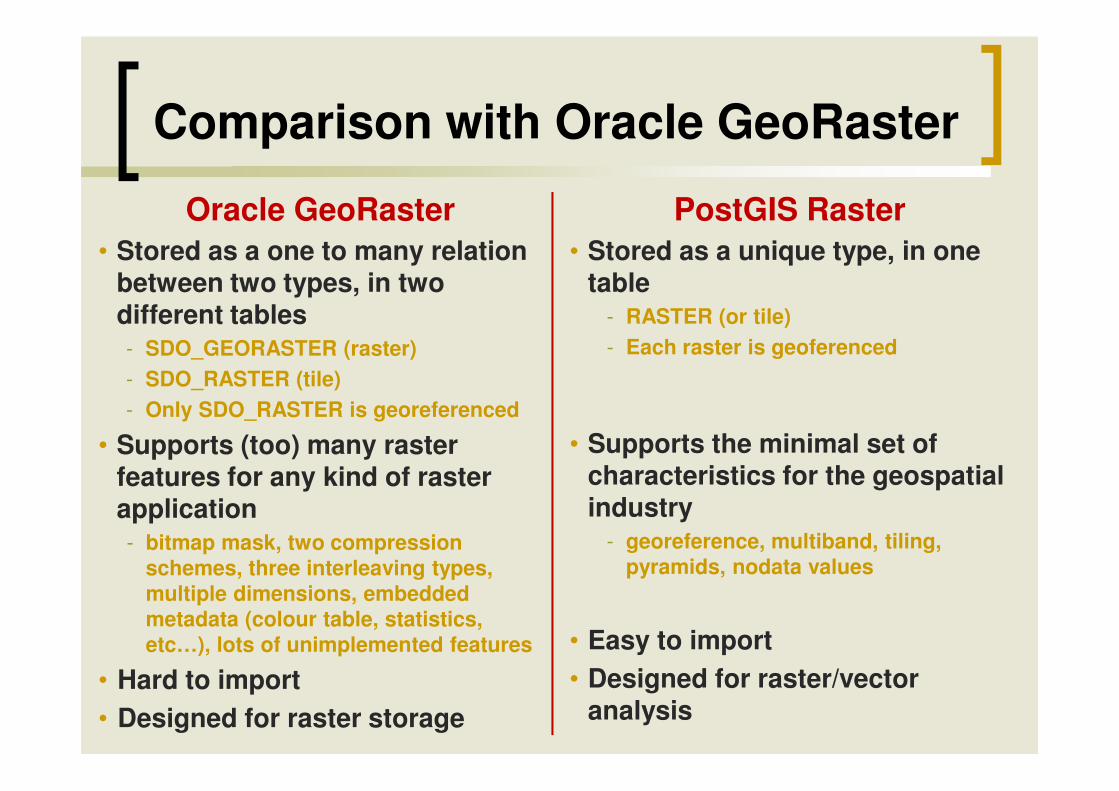
Comparison with Oracle GeoRaster
Oracle GeoRaster• Stored as a one to many relation
between two types, in twodifferent tables- SDO_GEORASTER (raster)- SDO_RASTER (tile)
PostGIS Raster• Stored as a unique type, in one
table- RASTER (or tile)- Each raster is geoferenced
- Only SDO_RASTER is georeferenced
• Supports (too) many raster features for any kind of raster application- bitmap mask, two compression
schemes, three interleaving types, multiple dimensions, embedded metadata (colour table, statistics, etc…), lots of unimplemented features
• Hard to import• Designed for raster storage
• Supports the minimal set of characteristics for the geospatialindustry
- georeference, multiband, tiling, pyramids, nodata values
• Easy to import• Designed for raster/vector
analysis
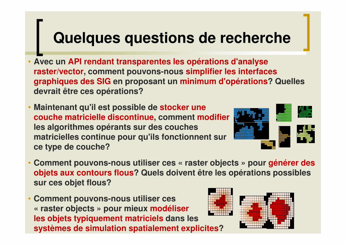
Quelques questions de recherche• Avec un API rendant transparentes les opérations d'analyse
raster/vector, comment pouvons-nous simplifier les interfaces graphiques des SIG en proposant un minimum d'opérations? Quelles devrait être ces opérations?
• Maintenant qu'il est possible de stocker une couche matricielle discontinue, comment modifierles algorithmes opérants sur des couches les algorithmes opérants sur des couches matricielles continue pour qu'ils fonctionnent sur ce type de couche?
• Comment pouvons-nous utiliser ces « raster objects » pour générer des objets aux contours flous? Quels doivent être les opérations possibles sur ces objet flous?
• Comment pouvons-nous utiliser ces « raster objects » pour mieux modéliser les objets typiquement matriciels dans les systèmes de simulation spatialement explicites?
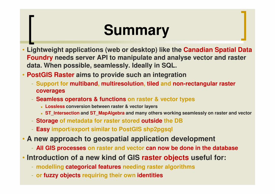
Summary• Lightweight applications (web or desktop) like the Canadian Spatial Data
Foundry needs server API to manipulate and analyse vector and raster data. When possible, seamlessly. Ideally in SQL.
• PostGIS Raster aims to provide such an integration- Support for multiband, multiresolution, tiled and non-rectangular raster
coverages- Seamless operators & functions on raster & vector types- Seamless operators & functions on raster & vector types
� Lossless conversion between raster & vector layers� ST_Intersection and ST_MapAlgebra and many others working seamlessly on raster and vector
- Storage of metadata for raster stored outside the DB- Easy import/export similar to PostGIS shp2pgsql
• A new approach to geospatial application development- All GIS processes on raster and vector can now be done in the database
• Introduction of a new kind of GIS raster objects useful for:- modelling categorical features needing raster algorithms- or fuzzy objects requiring their own identities

Thanks!
http://trac.osgeo.org/postgis/wiki/WKTRaster
Boreal AvianModelling Project


![[DAF 2015] L'analyse des données cross-canal chez vente-privee.fr](https://static.fdocuments.fr/doc/165x107/55bddaa2bb61eb00788b4786/daf-2015-lanalyse-des-donnees-cross-canal-chez-vente-priveefr.jpg)