
Information and Communication Technologies EASYWAY ...
24
Information and Communication Technologies EASYWAY OPERATING ENVIRONMENTS Deployment guideline ICT-DG01 | VERSION 01-02-00 | JANUARY 2012 COORDINATOR: RISTO KULMALA
Transcript of Information and Communication Technologies EASYWAY ...
Information and Communication Technologies
EASYWAY OPERATING ENVIRONMENTS
Deployment guideline ICT-DG01 | VERSION 01-02-00 | JANUARY 2012
COORDINATOR: RISTO KULMALA

Contributors Coordinator Risto Kulmala, Finnish Transport Agency, [email protected]
Coordinator support (name, organisation, country, email-address):
• Satu Innamaa, VTT, Finland, [email protected] • Jonas Sundberg, Sweco, Sweden, [email protected] • Christian Udin, Sweco, Sweden, [email protected]
Technical experts - revision process 2011 (company/organisation, country, name, email-address)
• Jürgen Neugebauser, Intrasys, Germany, [email protected] • Alain Reme, CETE MED, France, [email protected] • Reiner Dölger, Ministerium für Wirtschaft, Verkehr, Landwirtschaft und Weinbau, Germany,

3
ESG6 – INFORMATION AND COMMUNICATION TECHNOLOGIES
ICT-DG01 – EASYWAY OPERATING ENVIRONMENTS
COORDINATOR: RISTO KULMALA
ew-ict-dg01_operatingenvironments_01-02-00.docx 01/01/2012 3/24
EasyWay Operating Environments at a glance
WHAT ARE OPERATING ENVIRONMENTS?
The scope of EasyWay is to provide Core European Services to the European road users. These services are harmonized in content and functionality, but also in their availability: The road users shall be able to expect a certain services offer in a specific road environment. In order to provide a basis for the harmonization process EasyWay needs a tool to define such environments in an agreed manner. This tool is the Operating Environments – a set of pre-defined road environments combining physical layout of the road and network typology with traffic characteristics.
In essence, EasyWay has agreed on a set of 18 pre-defined Operating Environments (OE) where each OE is a combination of three criteria:
• Physical characteristics – Motorways, other 3/4 lane roads or 2-lane roads • Network typology – Corridor, Network, Link or Critical spot • Traffic characteristics – Traffic flow and road safety situations (with optional additions)
WHY DO EASYWAY PARTNERS BENEFIT FROM A ROAD NETWORK CLASSIFICATION
Classification means that EasyWay partners describe their actual road network as Operating Environments. By classifying their network into Operating Environments, the partner gets an immediate link between the actual road and the status of Core European Services as the EasyWay Deployment Guidelines provide a recommended service composition and design for each Operating Environment. Furthermore, network classification will give EasyWay partners a powerful tool to assess the current situation and discuss national and European deployment needs and strategies ahead.
HOW IS THE NETWORK CLASSIFICATION MADE?
Establish a task force
The first step in the process is to establish a task force (recommended 2-4 people) within the concerned road operator organization to decide on which background information to use, which criteria for flow and safety to use etc. This operation environments classification document gives suggestions on how to accomplish this, including a range of threshold values that are recommended to be applied in order to ensure a harmonized approach.
Road network definition
The next step in the classification process is to decide on the extent of the road network concerned – The EasyWay road network. In general this is the same as the TEN-T Road Network, with addition of other key road network elements, interfaces to urban networks etc. The precise extension of the network is decided by the EasyWay partner concerned. All elements will be matched with a common and gapless map database..
Classification
Classification is made through a link-by-link (from one exit/major junction to another exit/major junction) analysis supported by a dedicated excel-tool. By defining the value of the three criteria (above), the tool will provide the resulting Operating Environment in the excel table.

4
ESG6 – INFORMATION AND COMMUNICATION TECHNOLOGIES
ICT-DG01 – EASYWAY OPERATING ENVIRONMENTS
COORDINATOR: RISTO KULMALA
ew-ict-dg01_operatingenvironments_01-02-00.docx 01/01/2012 4/24
What resources are needed for road network classification?
According to the experiences of several EasyWay partners, a “typical” national partner’s road network will result in 200-500 links, 2-3 experts are able to carry out the classification within a few (2-4) working days when preparations (the first step) have been made.
How are the results used?
Following classification, an EasyWay partner will have a tool to compare the actual situation on its network with the recommended levels from the EasyWay Deployment Guidelines. This information can constitute valuable input to the partner deployment planning process as it reflects agreed European priorities. The partner can also use the network model to compile information on existing service implementations, service levels etc. which will further increase the value of the work. It is the aim of the EasyWay Technical Coordination Team to develop the excel tool further in this direction, and also to link it to a comprehensive map tool. A common map can display the state of development or planning on a pan-European scale with unambiguous reference to single network elements.
On the EasyWay European level, the results will be compiled and provide important information: Which are the Operating Environments in Europe, how are they distributed and how large part of the network do they constitute? This information will provide input for assessment of the remaining potential of the different Core European Services, and thus contribute to the EasyWay ITS Deployment Road Map. The aim is also to use the network model as the background for results compilation and reporting.

ew-ict-dg01_operatingenvironments_01-02-00.docx 01/01/2012 5/24
Table of Content 1 Introduction ............................................................................................................................................ 8
1.1 Objectives and scope of the document .............................................................................................. 8
1.2 Motivation for use of Operating Environments within EasyWay ......................................................... 8
1.3 Organisation of the Operating Environments classification in EasyWay .............................................. 8
2 EasyWay Operating Environments .......................................................................................................... 9
2.1 Understanding the classification criteria and attributes ................................................................... 10
2.1.1 Physical characteristics ................................................................................................................ 10
2.1.2 Network typology ........................................................................................................................ 11
2.1.3 Traffic flow impact ....................................................................................................................... 11
2.1.4 Road safety concerns ................................................................................................................... 12
2.1.5 Other attributes ........................................................................................................................... 12
2.2 Carrying out the classification in practice ......................................................................................... 13
2.2.1 Basic principles ............................................................................................................................ 13
2.2.2 Using the Excel support tool ........................................................................................................ 14
2.3 Reporting the classification .............................................................................................................. 16
3 Annex A: Reporting the Operating Environment classifications ............................................................ 20
4 Annex B: Use of Operating Environments for Service Level definition .................................................. 22

ew-ict-dg01_operatingenvironments_01-02-00.docx 01/01/2012 6/24
List of figures and tables Figure 1: Example of the contents of the excel worksheet for classification of EasyWay network into operating environments. Note that for map use, the start and the end points should be indicated by specific map attributes such as e.g. coordinates. ................................................................................................................... 15
Figure 2: The colour scheme to be used for the operating environments in the maps. ...................................... 16
Figure 3: Operating environments in Finland..................................................................................................... 17
Table 1: EasyWay operating environments for Core European ITS Services. ...................................................... 10
Table 2: Total lengths of road sections in each operating environment (example) ............................................ 18

ew-ict-dg01_operatingenvironments_01-02-00.docx 01/01/2012 7/24
List of abbreviations EW EasyWay
ICT Information and Communication Technologies
OE Operating Environment
TERN Trans-European Road Network

8
ESG6 – INFORMATION AND COMMUNICATION TECHNOLOGIES
ICT-DG01 – EASYWAY OPERATING ENVIRONMENTS
COORDINATOR: RISTO KULMALA
ew-ict-dg01_operatingenvironments_01-02-00.docx 01/01/2012 8/24
1 Introduction 1.1 Objectives and scope of the document
The aim of this document is to support and advise EasyWay partners in their classification of their EasyWay network into Operating Environments for EasyWay services.
By adopting the procedures specified in this document, the EasyWay partners will maximise the consistency of the operating environment classification throughout EasyWay
1.2 Motivation for use of Operating Environments within EasyWay
Operating Environments find their use in different ways within EasyWay: They are used in the Deployment Guidelines to describe the feasibility of different services in relation to the different environments on the EasyWay road network, and they are also used in the Road Map process as the basis for describing network extension and service level development concerning the Core European ITS services. Some examples of their use are illustrated in the Annex 2 of the document.
Operating Environments and deployment priorities
By describing the critical spots and the sections with most severe problems and concerns, the operating environments can be used in selection of the parts of the road network for improvement measures as well as for prioritising between the different road segments and connections when the road operator is implementing different measures.
Operating Environments and Service Levels –Tools for deployment planning
Operating Environments can also be used to steer and harmonise the implementation of Core ITS Services by the road operators in order to achieve harmonised service composition and harmonised service levels within a certain Operating Environment. To achieve this, there needs to be a description per Core ITS Service on adequate service levels to be applied in different Operating Environments.
Application of Operating Environments in Deployment Guidelines
EasyWay will use the definition of Operating Environments in the Deployment Guidelines in order to guide towards a harmonised service composition. The definition of service levels for European services in relation to Operating Environments will be developed further in the Deployment Guidelines.
Operating Environments in the Road Map process
By using the Operating Environments as the basis for the Road Map, rather than the physical road network, project partners can discuss deployment priorities in relation to an abstract network model, and then bring this information back into their national planning process. By adding the dimension of service level improvements and the dimension of time, the basic information required for an ITS deployment road map is in place.
1.3 Organisation of the Operating Environments classification in EasyWay
The Operating Environments (OE) classification work is coordinated by the OE Task Force operating under ICT Expert and Studies Group ESG6 in EasyWay,
Each EasyWay member state will nominate at least one contact person to be responsible for the OE classification work in their member state and for managing the liaison between partner-specific, national and EasyWay OE classification activities.
Experiences indicate that the technical classification of the national EasyWay network into operating environments will require only a few expert-days, after the national classification criteria have been agreed upon. The agreement on classification criteria may, however, demand much work and many discussions, if there are several EasyWay partners in the country with their own classification practices.

9
ESG6 – INFORMATION AND COMMUNICATION TECHNOLOGIES
ICT-DG01 – EASYWAY OPERATING ENVIRONMENTS
COORDINATOR: RISTO KULMALA
ew-ict-dg01_operatingenvironments_01-02-00.docx 01/01/2012 9/24
2 EasyWay Operating Environments The operating environments are defined as a combination of the following key factors:
• physical characteristics of the road section
• road section network typology
• traffic flow impact and/or road safety concerns
In addition, a specific road section may be characterized by attributes such as recurring weather problems, a particular sensitivity for environmental impacts or particular importance for freight transport. The classification method allows for such attributes to be added to the operating environment identified.
Full information on the operating environments can be found in the most recent version of the “Operating Environments for EasyWay Services1” available in the EasyWay Deployment Guidelines package.
The operating environments proposed for EasyWay Core European ITS services are defined in a step-by-step approach, in which a road operator can allocate a road or a section of a road (a network element), taking into account the indicators listed above. It has to be noted that the Operating Environments are obtained through a qualitative and sequential approach, in order to make it simple and easily used in any part of the road network.
The general layout is defined according to letter code to the different physical characteristics (following a slightly modified TELTEN1 approach):
• C for critical spots (bridges, tunnels, reversible lane sections, etc.)
• T for motorways
• R for roads
• S for motorway corridors or networks
• N for road corridors or networks
• P for peri-urban road networks
1 Ref TELTEN / TELTEN 2, Ertico 1997
10
ESG6 – INFORMATION AND COMMUNICATION TECHNOLOGIES
ICT-DG01 – EASYWAY OPERATING ENVIRONMENTS
COORDINATOR: RISTO KULMALA
ew-ict-dg01_operatingenvironments_01-02-00.docx 01/01/2012 10/24
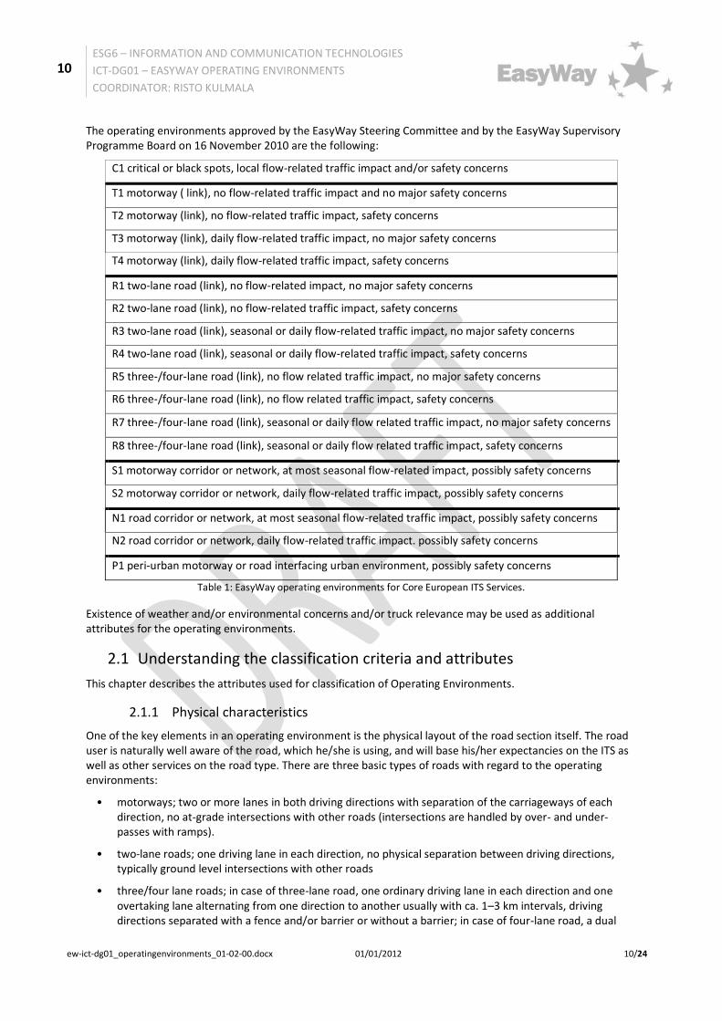
The operating environments approved by the EasyWay Steering Committee and by the EasyWay Supervisory Programme Board on 16 November 2010 are the following:
C1 critical or black spots, local flow-related traffic impact and/or safety concerns
T1 motorway ( link), no flow-related traffic impact and no major safety concerns
T2 motorway (link), no flow-related traffic impact, safety concerns
T3 motorway (link), daily flow-related traffic impact, no major safety concerns
T4 motorway (link), daily flow-related traffic impact, safety concerns
R1 two-lane road (link), no flow-related impact, no major safety concerns
R2 two-lane road (link), no flow-related traffic impact, safety concerns
R3 two-lane road (link), seasonal or daily flow-related traffic impact, no major safety concerns
R4 two-lane road (link), seasonal or daily flow-related traffic impact, safety concerns
R5 three-/four-lane road (link), no flow related traffic impact, no major safety concerns
R6 three-/four-lane road (link), no flow related traffic impact, safety concerns
R7 three-/four-lane road (link), seasonal or daily flow related traffic impact, no major safety concerns
R8 three-/four-lane road (link), seasonal or daily flow related traffic impact, safety concerns
S1 motorway corridor or network, at most seasonal flow-related impact, possibly safety concerns
S2 motorway corridor or network, daily flow-related traffic impact, possibly safety concerns
N1 road corridor or network, at most seasonal flow-related traffic impact, possibly safety concerns
N2 road corridor or network, daily flow-related traffic impact. possibly safety concerns
P1 peri-urban motorway or road interfacing urban environment, possibly safety concerns
Table 1: EasyWay operating environments for Core European ITS Services.
Existence of weather and/or environmental concerns and/or truck relevance may be used as additional attributes for the operating environments.
2.1 Understanding the classification criteria and attributes
This chapter describes the attributes used for classification of Operating Environments.
2.1.1 Physical characteristics
One of the key elements in an operating environment is the physical layout of the road section itself. The road user is naturally well aware of the road, which he/she is using, and will base his/her expectancies on the ITS as well as other services on the road type. There are three basic types of roads with regard to the operating environments:
• motorways; two or more lanes in both driving directions with separation of the carriageways of each direction, no at-grade intersections with other roads (intersections are handled by over- and under-passes with ramps).
• two-lane roads; one driving lane in each direction, no physical separation between driving directions, typically ground level intersections with other roads
• three/four lane roads; in case of three-lane road, one ordinary driving lane in each direction and one overtaking lane alternating from one direction to another usually with ca. 1–3 km intervals, driving directions separated with a fence and/or barrier or without a barrier; in case of four-lane road, a dual

11
ESG6 – INFORMATION AND COMMUNICATION TECHNOLOGIES
ICT-DG01 – EASYWAY OPERATING ENVIRONMENTS
COORDINATOR: RISTO KULMALA
ew-ict-dg01_operatingenvironments_01-02-00.docx 01/01/2012 11/24
carriageway road with separation of the two carriageways of two lanes each allowing also at-grade intersections
Only lanes for automobiles (including dedicated bus lanes) are included in the counting of lanes. If there are more than two lanes in at least one of the driving directions, but it is not a case of being a motorway, the road should be classified among the three/four lane roads. Hard shoulders should not be counted as lanes, even if used as temporary driving lanes.
In addition to the road types described above, the TERN has some physically distinct sections, which set special requirements to road services including ITS. Such sections are:
• tunnels, bridges, sections with reversible lanes, interchanges, junctions of restricted capacity between different basic types of roads other sections with exceptional characteristics. These types of infrastructure have been inserted in a general category of “critical spots” or “black spots” (see following section) where not only traffic problems may exist but also special services have to be applied.
2.1.2 Network typology
The road section concerned may also have a need for special service levels related to its role in the transport network. The roles important for the ITS service provision include:
• corridor; the road section is part of a long corridor connecting major cities and other key locations such as major ports including in total at least two alternative routes, of which at least one usually is a motorway. An additional requirement of a corridor is that the network or road operator manage the corridor as such at least in some of their network operation plans and schemes; i.e. if the road sections of the corridor are managed and operated (totally) independently of one another (except for using the alternative route for detour during incidents), the road sections are treated as links and spots.
• road/motorway network; grid of roads, motorways or a mix of roads and motorways.. As above with corridors, the road sections in a network should be operated by traffic management and/or information tools as a network, and not only as totally independent elements. If the same road element is part of both a corridor and a network, the typology of road/motorway network is the recommended choice.
• peri-urban network; the road section is part of a motorway or road network integrating the TERN with the road/street network of major conurbations. Typically, a ring road round an urban area is a part of this kind of network.
• link, a road/motorway section connecting two locations (spot or a node of a network/road such as city, port, etc) on the EasyWay network while not constituting a part of a corridor or road/motorway nor peri-urban network. A location separating two links is sometimes an intersection or any other place on the road/motorway, where the characteristics of the road/motorway change in such a way that the operating environment or its attributes will also change. This can happen for instance if the traffic volume suddenly increases or decreases drastically at an intersection, the road climate changes abruptly, etc.
• spot (or short stretch); a specific part of the road/motorway differing from the surrounding part of the TERN (critical bends, uphill section, tunnels, bridges, interchanges etc.) especially with regard to the need of specific ITS solutions.
This typology is a basis for defining operating environments and assigning a letter code to each type. Traffic flows and safety (see next points) will provide further details (distinguished with numbers).
Note that any section of the road/motorway can only belong to one typology. This is to ensure the summing up of the network lengths based on the Operating Environments.
2.1.3 Traffic flow impact
Observe that both for traffic flow impact and safety concerns, the road section is treated as a whole, consisting of both driving directions, even though in some cases the conditions might vary from one direction to the other. Again, this is done to ensure correct summing up of network lengths. If, however, a partner insists on

12
ESG6 – INFORMATION AND COMMUNICATION TECHNOLOGIES
ICT-DG01 – EASYWAY OPERATING ENVIRONMENTS
COORDINATOR: RISTO KULMALA
ew-ict-dg01_operatingenvironments_01-02-00.docx 01/01/2012 12/24
treating the directions as separate, this is allowed as long as this treatment is carried out consistently in the whole network of the country in question and specifically reported.
The existence of traffic flow impact is related to the actual flow situation on the specific road section in terms of traffic volumes.
It is quite obvious that ITS service levels need to be linked to the volume of traffic and how it varies in time. EasyWay aims at setting quantitative thresholds for annual average daily traffic (AADT) to set up the categories for traffic flow impact. This is described accordingly:
• daily traffic related impact; recurring congestion problems can affect traffic at least almost each working day, and incidents may also be quite frequent. If AADT is on motorways at least 12,500 veh/day per lane (i.e. 50,000 on 2+2, and 75,000 on 3+3 lane motorway) and on other roads at least 9,000 veh/day per lane (i.e. 18,000 on a 1+1 and 36,000 on a 2+2 lane road), the road should always be in this category.
• seasonal traffic related impact; severe traffic concerns can exist but only seasonally, for instance during weekends during vacation times and holidays. Note that the current operating environments do not explicitly address seasonal problems on motorway links. If such, however, exist, these roads should be included in the operating environments with daily problems.
• no traffic related impact; traffic related problems are infrequent and are usually caused only by major incidents or events. If AADT is on motorways less than 6,000 veh/day per lane (i.e. 24,000 on 2+2, and 36,000 on 3+3 lane motorway) and on other roads less than 4,000 veh/day per lane (i.e. 8,000 on a 1+1 and 16,000 on a 2+2 lane road), the road should always be in this category.
Note that the thresholds above leave room for EasyWay member states to use their own thresholds set according to national criteria. Naturally, also local circumstances can motivate deviation from the general principles and thresholds for specific road segments.
2.1.4 Road safety concerns
The existence of road safety concerns is related to the actual situation on the specific road section.
Two safety categories are to be used:
• safety concerns; accident rates are considered high or severe outcomes are expected from any crashes according to EasyWay partner; this can be due to e.g. severe weather problems related to snow, ice, fog and/or strong cross-winds affect traffic considerably and frequently – especially in the wintertime. Other reasons for this classification may be high percentage of heavy traffic, existence of vulnerable road users at the road side, risk of severe consequences on isolated mountain roads, old-fashioned or inadequate road design, etc.
There are three methods used to identify a section with safety concerns:
1) Road sections, where the long-term (preferable at least five-year average) severe accident rate (accidents/109 veh-km) is 30% higher than the country average,
2) Road sections, where the long-term fatality density (fatalities/100 road-km) is 30% higher than the country average, and
3) Road sections, where the EuroRAP rating is less than 3 stars (in scale 1-5).
The first method is recommended as the one most closely related to the safety experienced by the driver. Naturally, local circumstances can motivate deviation from the afore-mentioned methods and thresholds for specific road segments.
• no major safety related concerns; problems affecting road safety considerably are only occasional and infrequent.
2.1.5 Other attributes
The actual operating environments are determined on the basis of the attributes listed above. In addition to these, the EasyWay partners may also voluntarily choose to use additional criteria for classifying their road

13
ESG6 – INFORMATION AND COMMUNICATION TECHNOLOGIES
ICT-DG01 – EASYWAY OPERATING ENVIRONMENTS
COORDINATOR: RISTO KULMALA
ew-ict-dg01_operatingenvironments_01-02-00.docx 01/01/2012 13/24
network. Such additional attributes are most likely related to weather, environmental and heavy goods transport concerns. These attributes are elaborated upon below.
2.1.5.1 Existence of weather problems
The road/motorway is classified as having critical weather related problems, if severe weather problems related to snow, ice, fog and/or strong cross-winds affect traffic considerably and frequently - especially in the wintertime.
2.1.5.2 Existence of environmental concerns
The road/motorway section has critical environment concerns if it is passing through a area sensitive to environmental (pollution, noise) impact or affected by regulations such as groundwater areas, parks, residential areas, schools, playgrounds, etc.
2.1.5.3 Truck transport relevance
The link, corridor or network is of particular importance for freight transport. The proportion of heavy goods vehicles of all traffic or the average daily number of heavy goods vehicles are regarded as high by the EasyWay partner or the road/motorway is leading to a major logistics hub such as a port, airport (cargo), freight village etc.
2.2 Carrying out the classification in practice
2.2.1 Basic principles
This section describes how the EasyWay partners should classify their EasyWay road networks into EasyWay Operating Environments. The definition of what constitutes the EasyWay network is the one used by the EasyWay partner in question.
Note that if the EasyWay partner cannot classify a specific road section into any of the Operating Environment categories given in the document, the partner should choose the Operating Environment best fitting the specific road section, and to inform the authors of this document of the characteristics of all such sections poorly fitting into the current Operating Environments. Such cases will be considered when future versions of the Operating Environments are being proposed and when this classification guidance document is being updated. It should be noted that the ultimate goal is to achieve a consistent European methodology for classifying the EasyWay network into Operating Environments.
The classification method proposed takes into account the possibility of a later integration of the operating environment classification with a map-tool, allowing for network classification to be displayed through an EasyWay map-tool.
In practice, it seems to be easier to classify the EasyWay networks into operating environments criteria by criteria, as often each criteria is best dealt with by a specific expert. A congestion expert can easily classify the network by traffic flow impact, whereas another expert on safety will quickly classify the whole network according to the existence of safety concerns.
The whole EasyWay network is to be classified. For the classification, the network is to be divided into sections according to the basic factors determining the operating environment – physical layout, network typology, traffic flow impact and safety concerns as well as the additional attributes (weather, environment, freight), which the EasyWay partner chooses to use. This means that a new section could start each time, when the category of at least one of these factors and attributes changes. This may result in road sections of very varying health (from hundreds of metres to hundreds of kilometres). The EasyWay partners may also cut the sections also at other points, according to their own uses and preferences. The general recommendation is to use motorway exits and major junctions as the points of division for the road network, because this will simplify some later procedures such as map-matching. Hence, a road section normally runs from one exit/junction to another, but not necessarily the next one.
14
ESG6 – INFORMATION AND COMMUNICATION TECHNOLOGIES
ICT-DG01 – EASYWAY OPERATING ENVIRONMENTS
COORDINATOR: RISTO KULMALA
ew-ict-dg01_operatingenvironments_01-02-00.docx 01/01/2012 14/24
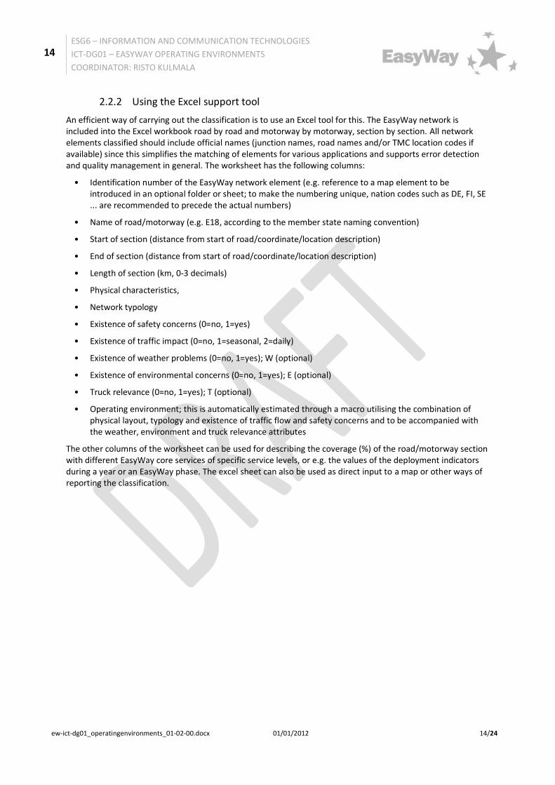
2.2.2 Using the Excel support tool
An efficient way of carrying out the classification is to use an Excel tool for this. The EasyWay network is included into the Excel workbook road by road and motorway by motorway, section by section. All network elements classified should include official names (junction names, road names and/or TMC location codes if available) since this simplifies the matching of elements for various applications and supports error detection and quality management in general. The worksheet has the following columns:
• Identification number of the EasyWay network element (e.g. reference to a map element to be introduced in an optional folder or sheet; to make the numbering unique, nation codes such as DE, FI, SE ... are recommended to precede the actual numbers)
• Name of road/motorway (e.g. E18, according to the member state naming convention)
• Start of section (distance from start of road/coordinate/location description)
• End of section (distance from start of road/coordinate/location description)
• Length of section (km, 0-3 decimals)
• Physical characteristics,
• Network typology
• Existence of safety concerns (0=no, 1=yes)
• Existence of traffic impact (0=no, 1=seasonal, 2=daily)
• Existence of weather problems (0=no, 1=yes); W (optional)
• Existence of environmental concerns (0=no, 1=yes); E (optional)
• Truck relevance (0=no, 1=yes); T (optional)
• Operating environment; this is automatically estimated through a macro utilising the combination of physical layout, typology and existence of traffic flow and safety concerns and to be accompanied with the weather, environment and truck relevance attributes
The other columns of the worksheet can be used for describing the coverage (%) of the road/motorway section with different EasyWay core services of specific service levels, or e.g. the values of the deployment indicators during a year or an EasyWay phase. The excel sheet can also be used as direct input to a map or other ways of reporting the classification.

15
ESG6 – INFORMATION AND COMMUNICATION TECHNOLOGIES
ICT-DG01 – EASYWAY OPERATING ENVIRONMENTS
COORDINATOR: RISTO KULMALA
ew-ict-dg01_operatingenvironments_01-02-00.docx 01/01/2012 15/24
If this will be done, the specifications for coverage will be provided at a later stage. An example of the excel sheet is given in Figure 1.
Figure 1: Example of the contents of the excel worksheet for classification of EasyWay network into operating environments. Note that for map use, the start and the end points should be indicated by specific map attributes such as
e.g. coordinates.
16
ESG6 – INFORMATION AND COMMUNICATION TECHNOLOGIES
ICT-DG01 – EASYWAY OPERATING ENVIRONMENTS
COORDINATOR: RISTO KULMALA
ew-ict-dg01_operatingenvironments_01-02-00.docx 01/01/2012 16/24
2.3 Reporting the classification
There are two main ways to report the classification in addition to the use of the Excel document as the final outcome. The target should be to connect the report directly to the classification of the operating environments in the Excel tool, so that the reports are more or less automatically generated after the data from the EasyWay network has been properly filled into the Excel worksheet.
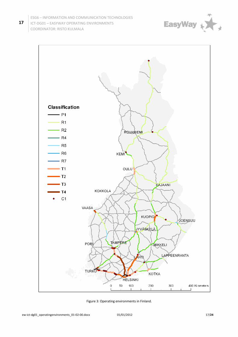
The first way of reporting is to use a map. Figure 3 indicates an example of classifying the road networks into operating environments on a map. Note that the traffic volumes in Finland (figure example) are so low resulting in so rare congestion problems that none of the parallel connections are today operated as corridors. The choice of the mapping software should comply with the mapping requirements of the overall EasyWay deployment monitoring and reporting being provided by the EasyWay Secretariat.
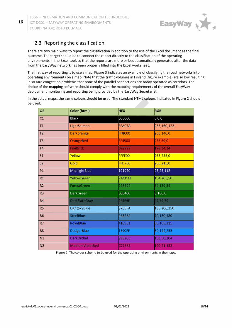
In the actual maps, the same colours should be used. The standard HTML colours indicated in Figure 2 should be used:
OE Color (html) HEX RGB
C1 Black 000000 0,0,0
T1 LightSalmon FFA07A 255,160,122
T2 Darkorange FF8C00 255,140,0
T3 OrangeRed FF4500 255,69,0
T4 FireBrick B22222 178,34,34
S1 Yellow FFFF00 255,255,0
S2 Gold FFD700 255,215,0
P1 MidnightBlue 191970 25,25,112
R1 YellowGreen 9ACD32 154,205,50
R2 ForestGreen 228B22 34,139,34
R3 DarkGreen 006400 0,100,0
R4 DarkSlateGray 2F4F4F 47,79,79
R5 LightSkyBlue 87CEFA 135,206,250
R6 SteelBlue 4682B4 70,130,180
R7 RoyalBlue 4169E1 65,105,225
R8 DodgerBlue 1E90FF 30,144,255
N1 DarkOrchid 9932CC 153,50,204
N2 MediumVioletRed C71585 199,21,133
Figure 2: The colour scheme to be used for the operating environments in the maps.
17
ESG6 – INFORMATION AND COMMUNICATION TECHNOLOGIES
ICT-DG01 – EASYWAY OPERATING ENVIRONMENTS
COORDINATOR: RISTO KULMALA
ew-ict-dg01_operatingenvironments_01-02-00.docx 01/01/2012 17/24
Figure 3: Operating environments in Finland.
18
ESG6 – INFORMATION AND COMMUNICATION TECHNOLOGIES
ICT-DG01 – EASYWAY OPERATING ENVIRONMENTS
COORDINATOR: RISTO KULMALA
ew-ict-dg01_operatingenvironments_01-02-00.docx 01/01/2012 18/24
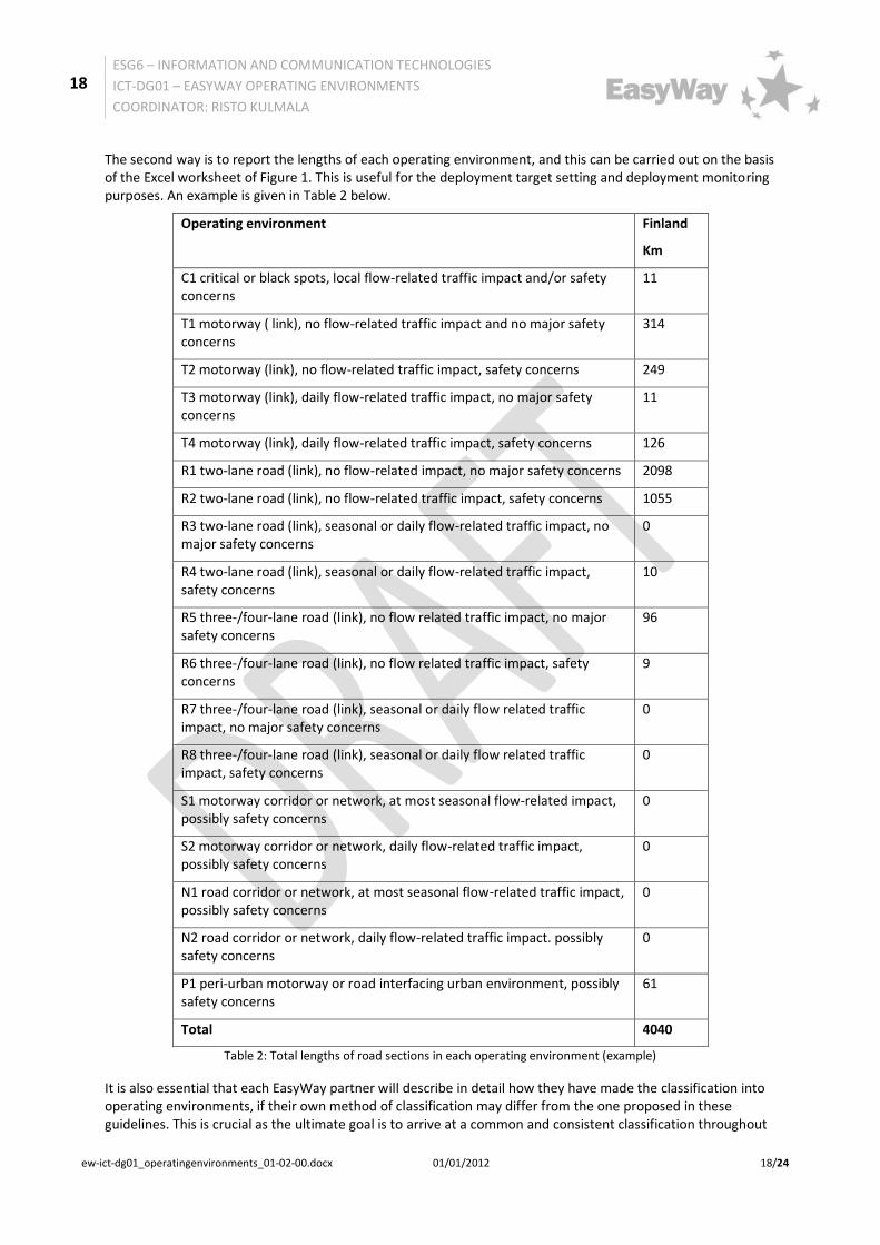
The second way is to report the lengths of each operating environment, and this can be carried out on the basis of the Excel worksheet of Figure 1. This is useful for the deployment target setting and deployment monitoring purposes. An example is given in Table 2 below.
Operating environment Finland
Km
C1 critical or black spots, local flow-related traffic impact and/or safety concerns
11
T1 motorway ( link), no flow-related traffic impact and no major safety concerns
314
T2 motorway (link), no flow-related traffic impact, safety concerns 249
T3 motorway (link), daily flow-related traffic impact, no major safety concerns
11
T4 motorway (link), daily flow-related traffic impact, safety concerns 126
R1 two-lane road (link), no flow-related impact, no major safety concerns 2098
R2 two-lane road (link), no flow-related traffic impact, safety concerns 1055
R3 two-lane road (link), seasonal or daily flow-related traffic impact, no major safety concerns
0
R4 two-lane road (link), seasonal or daily flow-related traffic impact, safety concerns
10
R5 three-/four-lane road (link), no flow related traffic impact, no major safety concerns
96
R6 three-/four-lane road (link), no flow related traffic impact, safety concerns
9
R7 three-/four-lane road (link), seasonal or daily flow related traffic impact, no major safety concerns
0
R8 three-/four-lane road (link), seasonal or daily flow related traffic impact, safety concerns
0
S1 motorway corridor or network, at most seasonal flow-related impact, possibly safety concerns
0
S2 motorway corridor or network, daily flow-related traffic impact, possibly safety concerns
0
N1 road corridor or network, at most seasonal flow-related traffic impact, possibly safety concerns
0
N2 road corridor or network, daily flow-related traffic impact. possibly safety concerns
0
P1 peri-urban motorway or road interfacing urban environment, possibly safety concerns
61
Total 4040
Table 2: Total lengths of road sections in each operating environment (example)
It is also essential that each EasyWay partner will describe in detail how they have made the classification into operating environments, if their own method of classification may differ from the one proposed in these guidelines. This is crucial as the ultimate goal is to arrive at a common and consistent classification throughout

19
ESG6 – INFORMATION AND COMMUNICATION TECHNOLOGIES
ICT-DG01 – EASYWAY OPERATING ENVIRONMENTS
COORDINATOR: RISTO KULMALA
ew-ict-dg01_operatingenvironments_01-02-00.docx 01/01/2012 19/24
EasyWay and its different partners. In order to reach a consensus it is essential that all involved understand the routines and cultures applied by each partner and their reasons for such ways of applications.
The template for reporting the classifications are given as Report 2 in Annex I of the document.
20
ESG6 – INFORMATION AND COMMUNICATION TECHNOLOGIES
ICT-DG01 – EASYWAY OPERATING ENVIRONMENTS
COORDINATOR: RISTO KULMALA
ew-ict-dg01_operatingenvironments_01-02-00.docx 01/01/2012 20/24
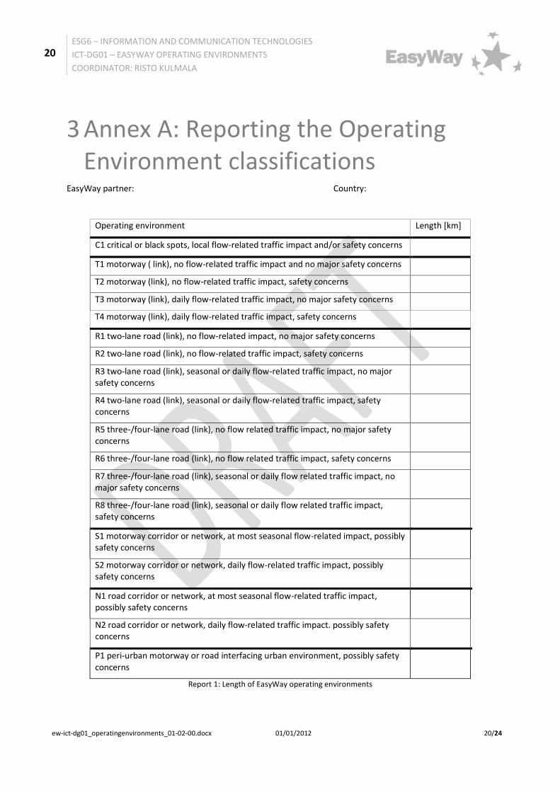
3 Annex A: Reporting the Operating Environment classifications
EasyWay partner: Country:
Operating environment Length [km]
C1 critical or black spots, local flow-related traffic impact and/or safety concerns
T1 motorway ( link), no flow-related traffic impact and no major safety concerns
T2 motorway (link), no flow-related traffic impact, safety concerns
T3 motorway (link), daily flow-related traffic impact, no major safety concerns
T4 motorway (link), daily flow-related traffic impact, safety concerns
R1 two-lane road (link), no flow-related impact, no major safety concerns
R2 two-lane road (link), no flow-related traffic impact, safety concerns
R3 two-lane road (link), seasonal or daily flow-related traffic impact, no major safety concerns
R4 two-lane road (link), seasonal or daily flow-related traffic impact, safety concerns
R5 three-/four-lane road (link), no flow related traffic impact, no major safety concerns
R6 three-/four-lane road (link), no flow related traffic impact, safety concerns
R7 three-/four-lane road (link), seasonal or daily flow related traffic impact, no major safety concerns
R8 three-/four-lane road (link), seasonal or daily flow related traffic impact, safety concerns
S1 motorway corridor or network, at most seasonal flow-related impact, possibly safety concerns
S2 motorway corridor or network, daily flow-related traffic impact, possibly safety concerns
N1 road corridor or network, at most seasonal flow-related traffic impact, possibly safety concerns
N2 road corridor or network, daily flow-related traffic impact. possibly safety concerns
P1 peri-urban motorway or road interfacing urban environment, possibly safety concerns
Report 1: Length of EasyWay operating environments

21
ESG6 – INFORMATION AND COMMUNICATION TECHNOLOGIES
ICT-DG01 – EASYWAY OPERATING ENVIRONMENTS
COORDINATOR: RISTO KULMALA
ew-ict-dg01_operatingenvironments_01-02-00.docx 01/01/2012 21/24
EasyWay partner: Country:
Method used in classification and any problems encountered and ways used to solve them (provide sufficient detail so that any other expert could also use the method)
Reason for choice of method
Road name, start and end point
Physical characteristics of road
Network typology
Traffic flow characteristics and impact
Safety concerns
Existence of weather problems
Existence of environmental concerns
Truck relevance
Provision of maps
Report 2: methods of classification of the operating environments
22
ESG6 – INFORMATION AND COMMUNICATION TECHNOLOGIES
ICT-DG01 – EASYWAY OPERATING ENVIRONMENTS
COORDINATOR: RISTO KULMALA
ew-ict-dg01_operatingenvironments_01-02-00.docx 01/01/2012 22/24
4 Annex B: Use of Operating Environments for Service Level definition
This annex gives some examples on the use of operating environments.
The first example shows how the operating environments are used in describing the service levels of core EasyWay ITC services.
The second example is about individual services and their service level requirements. The example attempts to illustrate that the same service levels tend to apply to very many operating environments.
The third example tries to show how the operating environments can be used to set service levels to ICT infrastructures. These kinds of decisions are being regularly made by the EasyWay partners. In such a case, the service level demanded in an operating environment depends on the different services provided in the operating environment, and the decision maker can with the help of such analysis choose the level of service aimed for.
Example 1: Use in EasyWay Deployment Guidelines
The EasyWay Deployment Guidelines present the Levels of Service in each operating environments such as below for Weather information services.
Note that in these descriptions, M stands for the minimum and O for the optimum level of service. As seen from the example, it may be useful to combine all Operating Environments having the same level of service in order to simplify the table.
Example 2: ITS Services A and B
One way to describe the service or quality level requirements for ITS services which depend on the operating environment is shown in Table A2-1. Based on the ITS services (e.g. ITS service A and B) the relevant operating environment is assigned to each service and the minimum service level requirements are defined with the help of 5 parameters. This description is particularly suitable if the minimum service level requirements are similar for different operating environments.
C1 T1 T2 T3 T4 R1 R2 R3 R4 R5 R6 R7 R8 S1 S2 N1 N2 P1
C
Information available is capable of
being provided independent of
language
O
B
Data available is capable of being
provided in a common and shared
language (English).
M O OM O OM O OM O O OM O OM OM OM OM OM OM
AOne fixed language (all official
languages)M M M M OM M M
CNeighbouring and beyond
information provider exchange
BInformation exchange to
neighbouring onlyO O O O O O O O O O O O O O O O O O
A No information exchange M M M M M M M M M M M M M M M M M M
C
Additional information on local
routes with impact on the TEN-T road
network
O
BExchange and use for strategic non
TEN-T road network (key roads)O O O O O O O O O O O O O O O O O
ANone (only information on TEN-T road
network)M M M M M M M M M M M M M M M M M M
CWeather information and weather
warning nowcast and forecastO O O O O O O O O O O O
BWeather information and weather
warningM O M O M O M O M O M O M M M M M M
A Weather Information M M M M M M
M Minimum LoS recommended O Optimum LoS recommended
OM Minimum = Optimum NA Non applicable / non relevant
TIS-DG06:
WEATHER INFORMATION SERVICESEasyWay OPERATING ENVIRONMENT
Criteria for the Levels of Service
Recommendations for LoS per OE:
User Interface
Neighbouring
Provision
Local and
secondary
Network
Information
Level of
information

23
ESG6 – INFORMATION AND COMMUNICATION TECHNOLOGIES
ICT-DG01 – EASYWAY OPERATING ENVIRONMENTS
COORDINATOR: RISTO KULMALA
ew-ict-dg01_operatingenvironments_01-02-00.docx 01/01/2012 23/24
Table A2-1. Minimum service levels for two ITS Services in different operating environments in EasyWay
Example 3: ICT infrastructure for many services
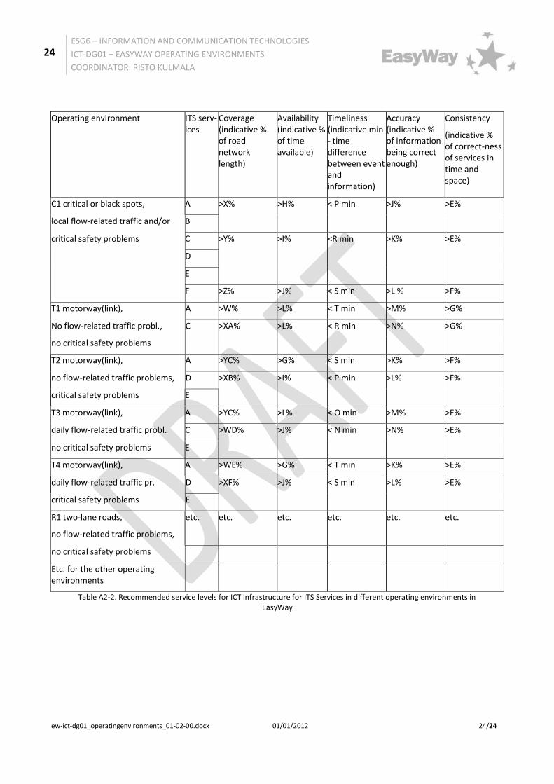
A further possibility to describe the minimum service level requirements for ITS services, depending on the operating environment, is shown in Table A2-2. Based on the operating environment, various ITS services are assigned. For these ITS services, the respective minimum service levels are also defined by using the 5 parameters. The minimum service levels are defined separately for each ITS service.
ITS service
Operating environment
Coverage (indicative % of road network length)
Availability (indicative % of time available)
Timeliness (indicative min - time difference between event and information)
Accuracy (indicative % of information being correct enough)
Consistency (indicative % of correctness of services in time and space)
A All except for R1-R2
>X% >A% < B min >D% >E%
R1, R2 >Y% >A% < C min >D% >F%
B C1 with surround-ings
>W% >G% < I min >K% >M%
Other >Z% >H% < j min >L% >N%
24
ESG6 – INFORMATION AND COMMUNICATION TECHNOLOGIES
ICT-DG01 – EASYWAY OPERATING ENVIRONMENTS
COORDINATOR: RISTO KULMALA
ew-ict-dg01_operatingenvironments_01-02-00.docx 01/01/2012 24/24
Operating environment ITS serv-ices
Coverage (indicative % of road network length)
Availability (indicative % of time available)
Timeliness (indicative min - time difference between event and information)
Accuracy (indicative % of information being correct enough)
Consistency
(indicative % of correct-ness of services in time and space)
C1 critical or black spots, A >X% >H% < P min >J%
>E%
local flow-related traffic and/or B
critical safety problems C >Y% >I% <R min
>K% >E%
D
E
F >Z% >J% < S min >L % >F%
T1 motorway(link), A >W% >L% < T min >M% >G%
No flow-related traffic probl., C
>XA% >L% < R min >N%
>G%
no critical safety problems
T2 motorway(link), A >YC% >G% < S min >K% >F%
no flow-related traffic problems, D >XB% >I% < P min >L%
>F%
critical safety problems E
T3 motorway(link), A >YC% >L% < O min >M% >E%
daily flow-related traffic probl. C >WD% >J% < N min >N%
>E%
no critical safety problems E
T4 motorway(link), A >WE% >G% < T min >K% >E%
daily flow-related traffic pr. D >XF% >J% < S min >L%
>E%
critical safety problems E
R1 two-lane roads,
no flow-related traffic problems,
etc. etc. etc. etc. etc. etc.
no critical safety problems
Etc. for the other operating environments
Table A2-2. Recommended service levels for ICT infrastructure for ITS Services in different operating environments in EasyWay