Current works of the Expert Group Geodesy of EuroGeographics TWG minutes/36-Prague2004/23... · •...
29
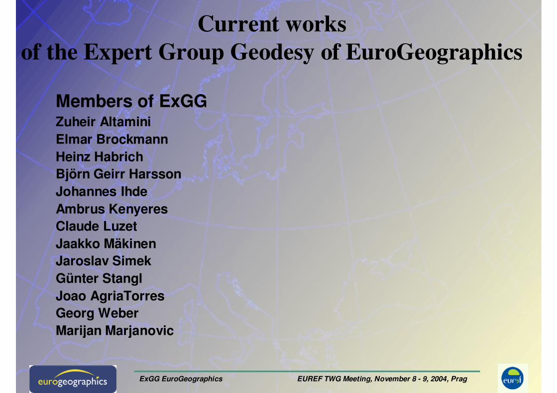
ExGG EuroGeographics EUREF TWG Meeting, November 8 - 9, 2004, Prag Current works of the Expert Group Geodesy of EuroGeographics Members of ExGG Zuheir Altamini Elmar Brockmann Heinz Habrich Björn Geirr Harsson Johannes Ihde Ambrus Kenyeres Claude Luzet Jaakko Mäkinen Jaroslav Simek Günter Stangl Joao AgriaTorres Georg Weber Marijan Marjanovic
Transcript of Current works of the Expert Group Geodesy of EuroGeographics TWG minutes/36-Prague2004/23... · •...
ExGG EuroGeographics EUREF TWG Meeting, November 8 - 9, 2004, Prag
Current works
of the Expert Group Geodesy of EuroGeographics
Members of ExGGZuheir AltaminiElmar BrockmannHeinz HabrichBjörn Geirr HarssonJohannes IhdeAmbrus Kenyeres Claude Luzet Jaakko MäkinenJaroslav SimekGünter StanglJoao AgriaTorresGeorg WeberMarijan Marjanovic
ExGG EuroGeographics EUREF TWG Meeting, November 8 - 9, 2004, Prag
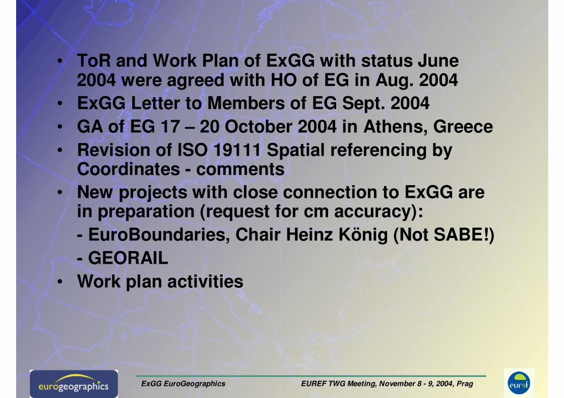
• ToR and Work Plan of ExGG with status June 2004 were agreed with HO of EG in Aug. 2004
• ExGG Letter to Members of EG Sept. 2004• GA of EG 17 – 20 October 2004 in Athens, Greece• Revision of ISO 19111 Spatial referencing by
Coordinates - comments• New projects with close connection to ExGG are
in preparation (request for cm accuracy): - EuroBoundaries, Chair Heinz König (Not SABE!)- GEORAIL
• Work plan activities
ExGG EuroGeographics EUREF TWG Meeting, November 8 - 9, 2004, Prag
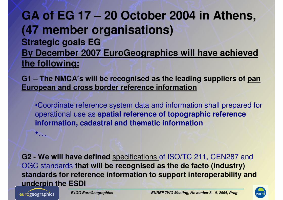
GA of EG 17 – 20 October 2004 in Athens, (47 member organisations)Strategic goals EGBy December 2007 EuroGeographics will have achieved the following:
G1 – The NMCA’s will be recognised as the leading suppliers of pan European and cross border reference information
•Coordinate reference system data and information shall prepared for
operational use as spatial reference of topographic reference information, cadastral and thematic information•…
G2 - We will have defined specifications of ISO/TC 211, CEN287 and
OGC standards that will be recognised as the de facto (industry)standards for reference information to support interoperability andunderpin the ESDI
ExGG EuroGeographics EUREF TWG Meeting, November 8 - 9, 2004, Prag
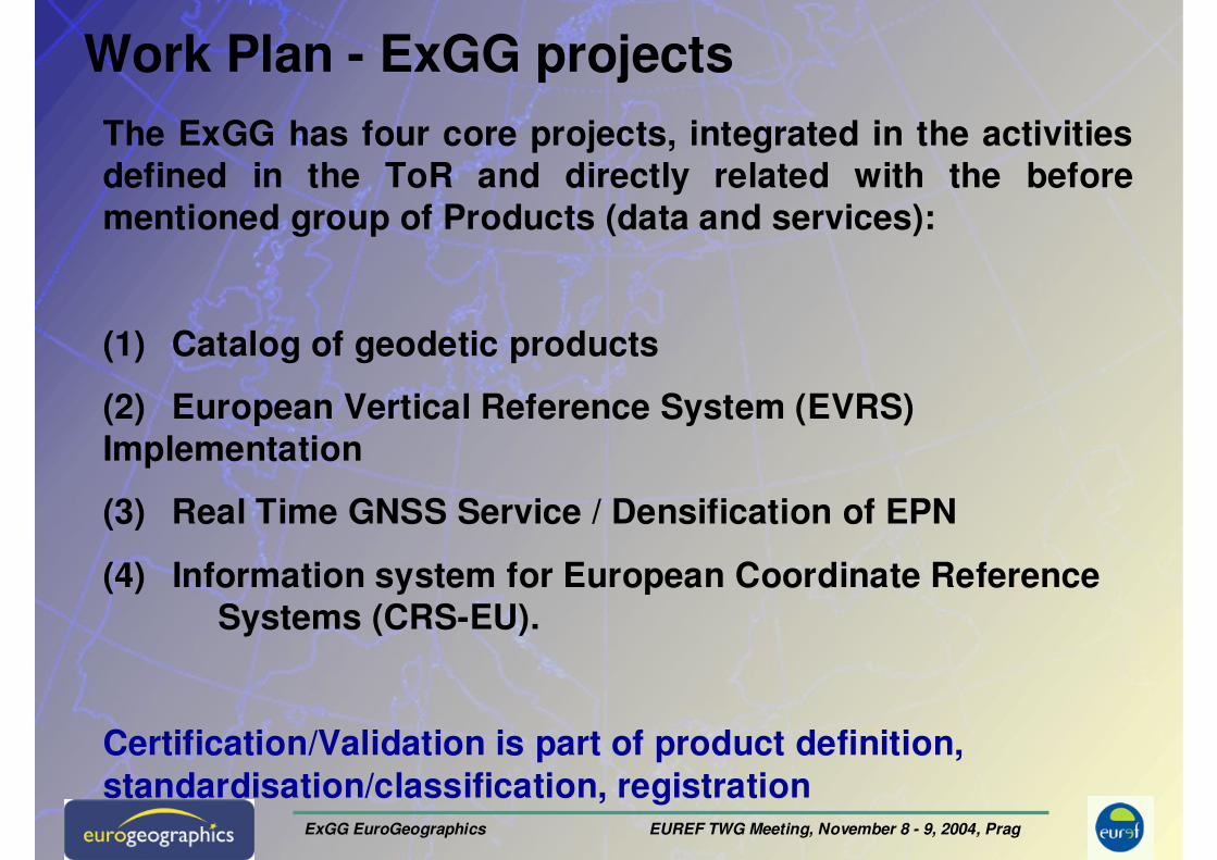
Work Plan - ExGG projects
The ExGG has four core projects, integrated in the activities defined in the ToR and directly related with the before mentioned group of Products (data and services):
(1) Catalog of geodetic products
(2) European Vertical Reference System (EVRS) Implementation
(3) Real Time GNSS Service / Densification of EPN
(4) Information system for European Coordinate Reference Systems (CRS-EU).
Certification/Validation is part of product definition, standardisation/classification, registration
ExGG EuroGeographics EUREF TWG Meeting, November 8 - 9, 2004, Prag
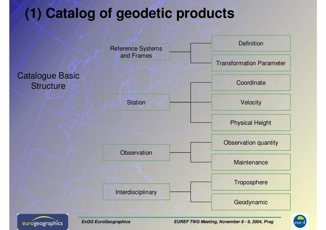
(1) Catalog of geodetic products
Reference Systems and Frames
Station
Observation
Interdisciplinary
Definition
Transformation Parameter
Coordinate
Velocity
Troposphere
Geodynamic
Physical Height
Observation quantity
Maintenance
Catalogue Basic
Structure
ExGG EuroGeographics EUREF TWG Meeting, November 8 - 9, 2004, Prag
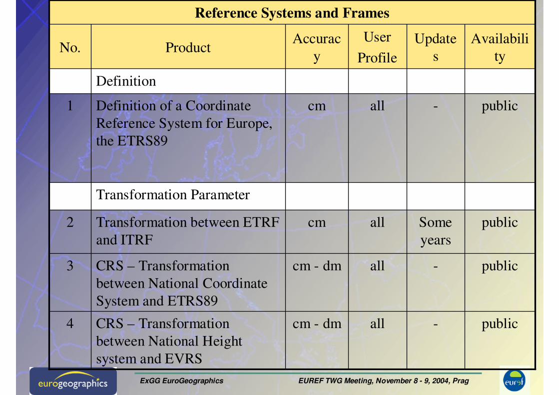
Product Catalogue
public-allcm - dmCRS – Transformation
between National Height
system and EVRS
4
public-allcm - dmCRS – Transformation
between National Coordinate
System and ETRS89
3
Reference Systems and Frames
publicSome
years
allcmTransformation between ETRF
and ITRF
2
Transformation Parameter
public-allcmDefinition of a Coordinate
Reference System for Europe,
the ETRS89
1
Definition
Availabili
ty
Update
s
User
Profile
Accurac
yProductNo.
ExGG EuroGeographics EUREF TWG Meeting, November 8 - 9, 2004, Prag
Product Catalogue
ITRF
ETRF
ITRF
ITRF
Referen
ce
Frame
GNSS
GNSS
combine
d
GNSS
Geodetic
Techniq
ue
3
some
years
some
years
3
weeks
Latenc
y
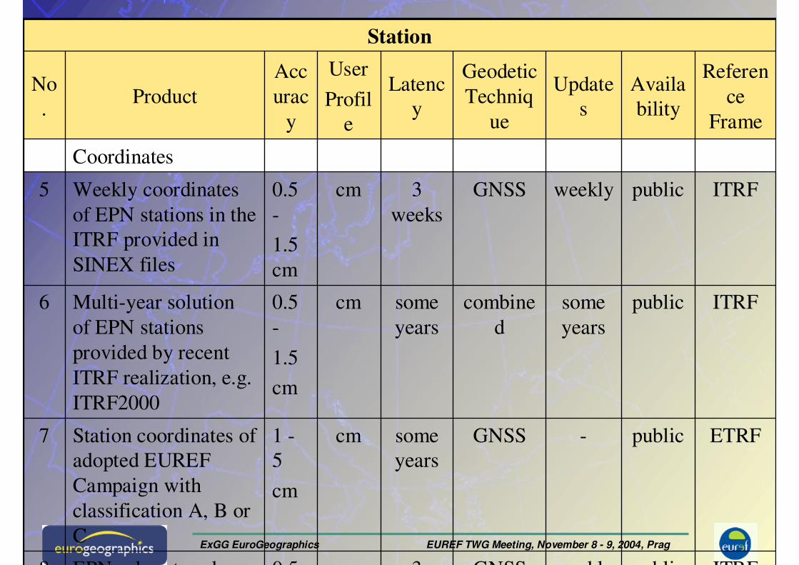
publicweeklycm0.5 EPN sub-network 8
Station
public-cm1 -
5
cm
Station coordinates of
adopted EUREF
Campaign with
classification A, B or
C
7
publicsome
years
cm0.5
-
1.5
cm
Multi-year solution
of EPN stations
provided by recent
ITRF realization, e.g.
ITRF2000
6
publicweeklycm0.5
-
1.5
cm
Weekly coordinates
of EPN stations in the
ITRF provided in
SINEX files
5
Coordinates
Availa
bility
Update
s
User
Profil
e
Acc
urac
y
ProductNo
.
ExGG EuroGeographics EUREF TWG Meeting, November 8 - 9, 2004, Prag
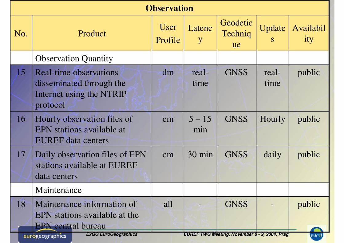
Product Catalogue
public-GNSS-allMaintenance information of
EPN stations available at the
EPN central bureau
18
GNSS
GNSS
GNSS
Geodetic
Techniq
ue
30 min
5 – 15
min
real-
time
Latenc
y
Maintenance
Observation
publicdailycmDaily observation files of EPN
stations available at EUREF
data centers
17
publicHourlycmHourly observation files of
EPN stations available at
EUREF data centers
16
publicreal-
time
dmReal-time observations
disseminated through the
Internet using the NTRIP
protocol
15
Observation Quantity
Availabil
ity
Update
s
User
ProfileProductNo.
ExGG EuroGeographics EUREF TWG Meeting, November 8 - 9, 2004, Prag
Product Catalogue
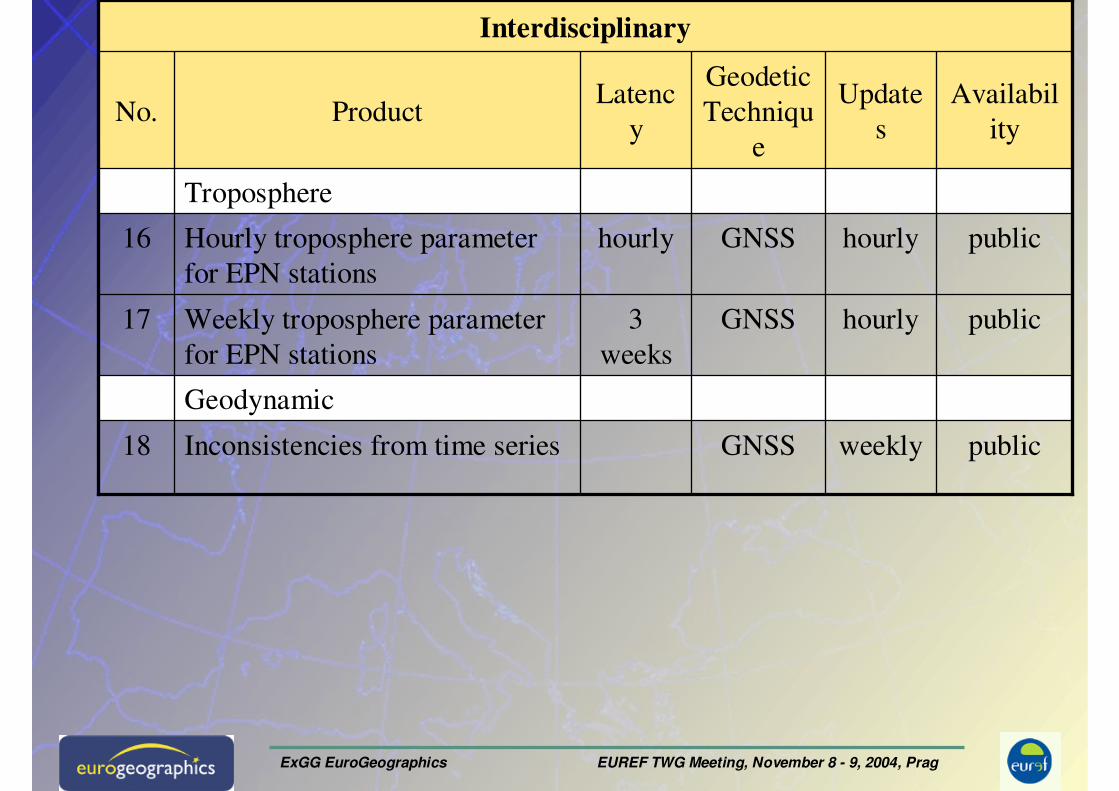
publicweeklyGNSSInconsistencies from time series18
GNSS
GNSS
Geodetic
Techniqu
e
3
weeks
hourly
Latenc
y
Geodynamic
Interdisciplinary
publichourlyWeekly troposphere parameter
for EPN stations
17
publichourlyHourly troposphere parameter
for EPN stations
16
Troposphere
Availabil
ity
Update
sProductNo.
ExGG EuroGeographics EUREF TWG Meeting, November 8 - 9, 2004, Prag
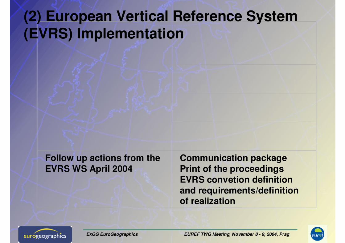
Follow up actions from the EVRS WS April 2004
Communication packagePrint of the proceedingsEVRS convetion definition and requirements/definition of realization
(2) European Vertical Reference System (EVRS) Implementation
ExGG EuroGeographics EUREF TWG Meeting, November 8 - 9, 2004, Prag
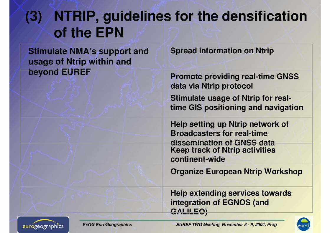
(3) NTRIP, guidelines for the densification of the EPN
Stimulate NMA’s support and usage of Ntrip within and beyond EUREF
Spread information on Ntrip
Promote providing real-time GNSS data via Ntrip protocol
Stimulate usage of Ntrip for real-time GIS positioning and navigation
Help setting up Ntrip network of Broadcasters for real-time dissemination of GNSS dataKeep track of Ntrip activities continent-wide
Organize European Ntrip Workshop
Help extending services towards integration of EGNOS (and GALILEO)

ExGG EuroGeographics EUREF TWG Meeting, November 8 - 9, 2004, Prag
(4) Information system for geodetic CRS, transformation parameters CRS-EU
Preparation of information for describing European and national height reference systems and extension of the CRS data base
Preparation of information for describing European and national height reference systems
Letter to NMA’s
Extension of the CRS data base by height information
Concept for geoid information
On-line transformation
ExGG EuroGeographics EUREF TWG Meeting, November 8 - 9, 2004, Prag
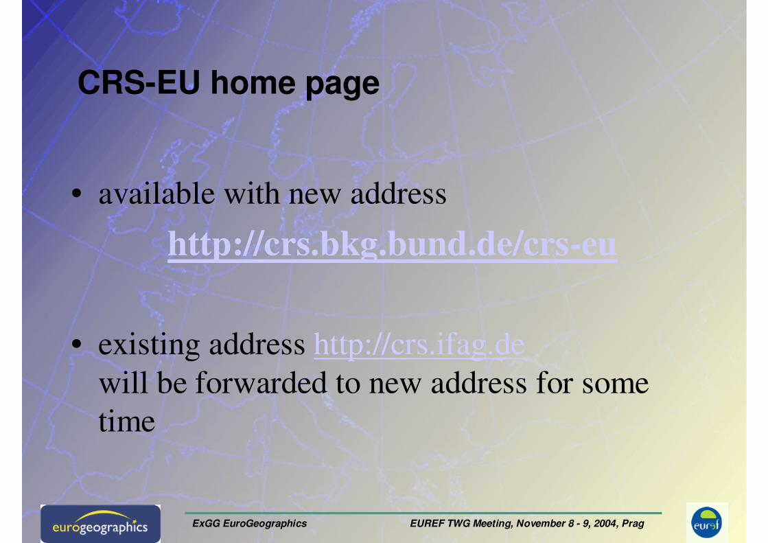
CRS-EU home page
• available with new address
http://crs.bkg.bund.de/crs-eu
• existing address http://crs.ifag.de
will be forwarded to new address for some
time
ExGG EuroGeographics EUREF TWG Meeting, November 8 - 9, 2004, Prag
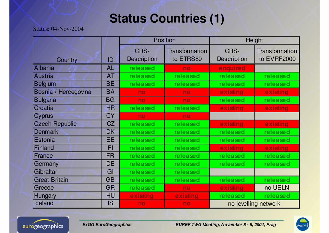
Status Countries (1)Status: 04-Nov-2004
CRS-
Description
Transformation
to ETRS89
CRS-
Description
Transformation
to EVRF2000
Albania AL released no enquiredAustria AT released released released releasedBelgium BE released released released releasedBosnia / Hercegovina BA no no existing existingBulgaria BG no no released releasedCroatia HR released released existing existingCyprus CY no noCzech Republic CZ released released existing existingDenmark DK released released released releasedEstonia EE released released released releasedFinland FI released released existing existingFrance FR released released released releasedGermany DE released released released releasedGibraltar GI released releasedGreat Britain GB released released released releasedGreece GR released no existing no UELN
Hungary HU existing existing released releasedIceland IS no no no levelling network
Country ID
Position Height
ExGG EuroGeographics EUREF TWG Meeting, November 8 - 9, 2004, Prag
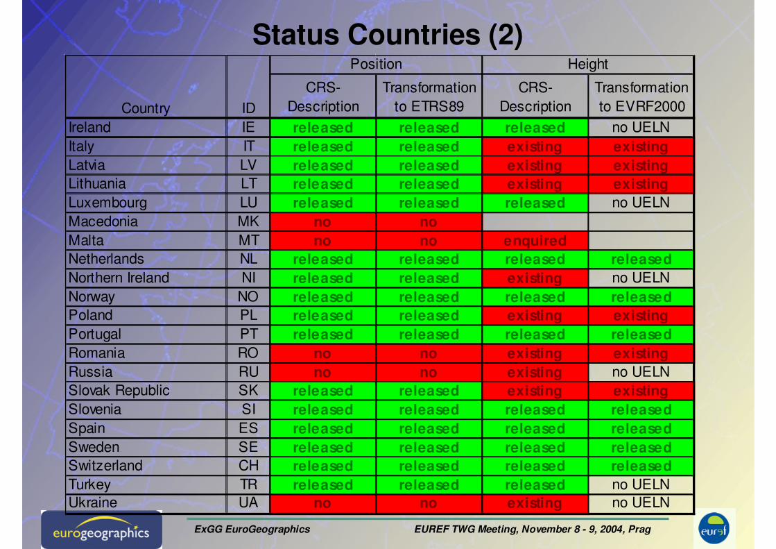
Status Countries (2)
CRS-
Description
Transformation
to ETRS89
CRS-
Description
Transformation
to EVRF2000
Ireland IE released released released no UELN
Italy IT released released existing existingLatvia LV released released existing existingLithuania LT released released existing existingLuxembourg LU released released released no UELN
Macedonia MK no noMalta MT no no enquiredNetherlands NL released released released releasedNorthern Ireland NI released released existing no UELN
Norway NO released released released releasedPoland PL released released existing existingPortugal PT released released released releasedRomania RO no no existing existingRussia RU no no existing no UELN
Slovak Republic SK released released existing existingSlovenia SI released released released releasedSpain ES released released released releasedSweden SE released released released releasedSwitzerland CH released released released releasedTurkey TR released released released no UELN
Ukraine UA no no existing no UELN
Country ID
Position Height
ExGG EuroGeographics EUREF TWG Meeting, November 8 - 9, 2004, Prag
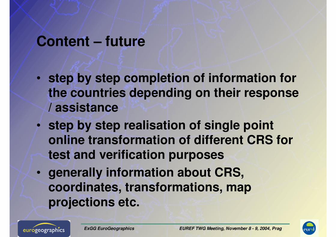
Content – future
• step by step completion of information for the countries depending on their response/ assistance
• step by step realisation of single point online transformation of different CRS for test and verification purposes
• generally information about CRS, coordinates, transformations, map projections etc.
ExGG EuroGeographics EUREF TWG Meeting, November 8 - 9, 2004, Prag
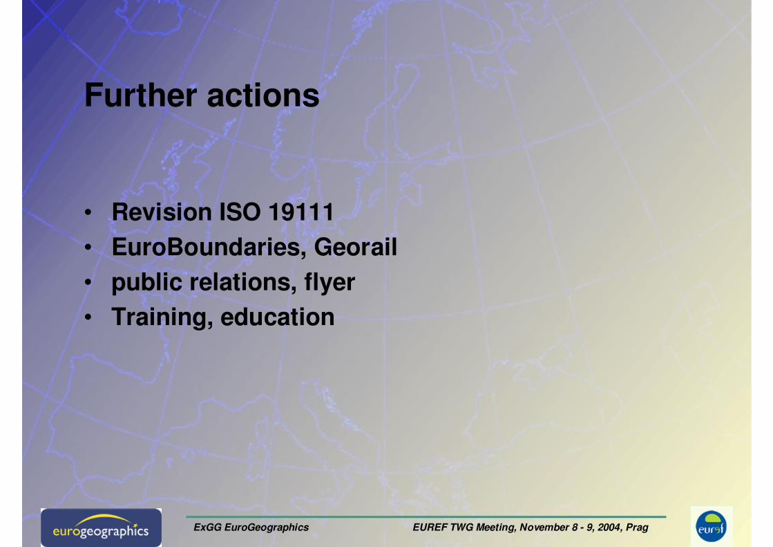
Further actions
• Revision ISO 19111
• EuroBoundaries, Georail
• public relations, flyer
• Training, education
ExGG EuroGeographics EUREF TWG Meeting, November 8 - 9, 2004, Prag
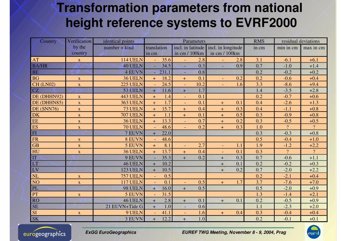
identical points Parameters RMS residual deviations Country Verification
by the
country number + kind translation
in cm incl. in latitude in cm / 100km
incl. in longitude in cm / 100km
in cm min in cm max in cm
AT x 114 UELN - 35.6 - 2.8 - 2.8 3.1 -6.1 +6.1
BA/HR 40 UELN - 34.5 - 0.3 - 0.9 0.7 -1.0 +1.4
BE 4 EUVN - 231.1 - 0.8 0.2 -0.2 +0.2
BG x 36 UELN + 18.2 + 0.1 - 0.2 0.2 -0.6 +0.4
CH (LN02) x 225 UELN - 24.5 - 10.2 - 1.6 3.3 -8.6 +9.4
CZ 53 UELN + 11.6 + 1.7 1.4 -3.5 +2.8
DE (DHHN92) x 443 UELN + 1.4 - 0.1 0.2 -0.7 +0.6
DE (DHHN85) x 363 UELN + 1.7 - 0.1 + 0.1 0.4 -2.6 +1.3
DE (SNN76) x 73 UELN + 15.7 + 0.4 + 0.3 0.4 -1.1 +0.8
DK x 707 UELN + 1.1 + 0.1 + 0.5 0.3 -0.9 +0.8
EE x 36 UELN + 13.3 - 0.7 + 0.2 0.3 -0.5 +0.5
ES x 70 UELN - 48.6 - 0.2 + 0.3 1.0 ? ?
FI 7 EUVN + 22.0 0.3 -0.3 +0.8
FR x 8 EUVN - 48.6 0.5 -0.4 +1.0
GB x 5 EUVN + 8.1 - 2.7 - 1.1 1.9 -1.2 +2.2
HU x 36 UELN + 13.7 + 0.4 - 0.1 0.3 ? ?
IT 9 EUVN - 35.3 + 0.2 + 0.3 0.7 -0.6 +1.1
LT 46 UELN + 10.2 + 0.1 0.2 -0.2 +0.3
LV 123 UELN + 10.5 + 0.2 0.7 -2.0 +2.2
NL x 757 UELN - 0.5 0.2 -2.1 +0.4
NO x 117 UELN - 0.1 - 0.5 + 1.7 3.7 -7.6 +7.0
PL 98 UELN + 16.0 + 0.5 0.5 -2.0 +0.9
PT x 5 EUVN - 31.5 1.3 -1.4 +2.1
RO 46 UELN + 2.8 + 0.1 + 0.1 0.2 -0.5 +0.9
SE 21 EUVN+Tide G + 1.0 - 0.6 1.1 -2.3 +2.0
SI x 9 UELN - 41.1 - 1.6 + 0.4 0.3 -0.4 +0.4
SK 3 EUVN + 12.2 + 1.0 0.2 -0.1 +0.1
Transformation parameters from nationalheight reference systems to EVRF2000
ExGG EuroGeographics EUREF TWG Meeting, November 8 - 9, 2004, Prag
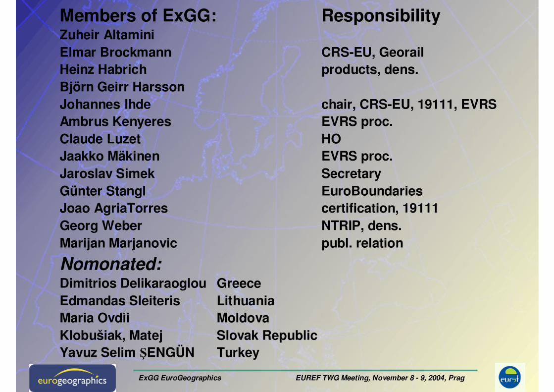
Members of ExGG: ResponsibilityZuheir AltaminiElmar Brockmann CRS-EU, GeorailHeinz Habrich products, dens.Björn Geirr HarssonJohannes Ihde chair, CRS-EU, 19111, EVRSAmbrus Kenyeres EVRS proc.Claude Luzet HOJaakko Mäkinen EVRS proc.Jaroslav Simek SecretaryGünter Stangl EuroBoundariesJoao AgriaTorres certification, 19111Georg Weber NTRIP, dens.Marijan Marjanovic publ. relation
Nomonated:Dimitrios Delikaraoglou GreeceEdmandas Sleiteris LithuaniaMaria Ovdii MoldovaKlobušiak, Matej Slovak RepublicYavuz Selim ŞENGÜN Turkey
ExGG EuroGeographics EUREF TWG Meeting, November 8 - 9, 2004, Prag
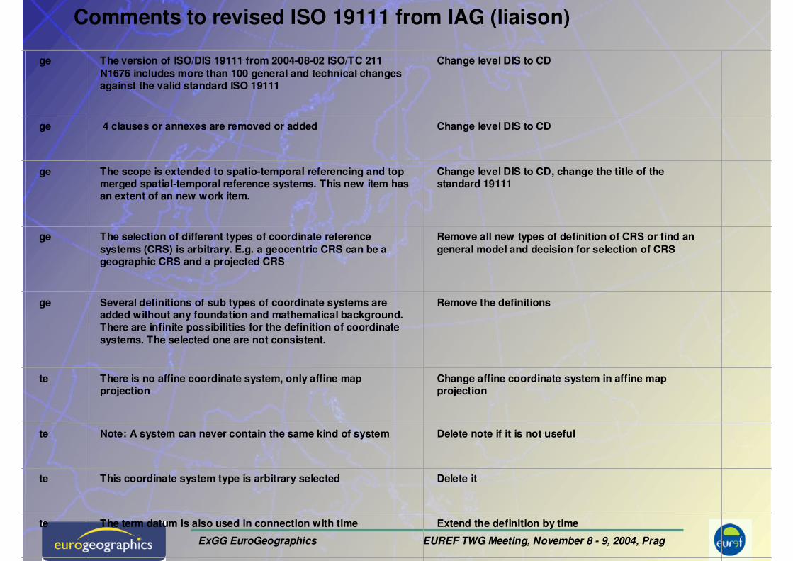
projection projection
te Note: A system can never contain the same kind of system
Delete note if it is not useful
te This coordinate system type is arbitrary selected Delete it
te The term datum is also used in connection with time Extend the definition by time
te A coordinate reference system has an origin orientation and scale
Delete reference
te For description of a position in a coordinate system sometimes thousands of measurements necessary in dependence of accuracy
Delete “of measurements or”
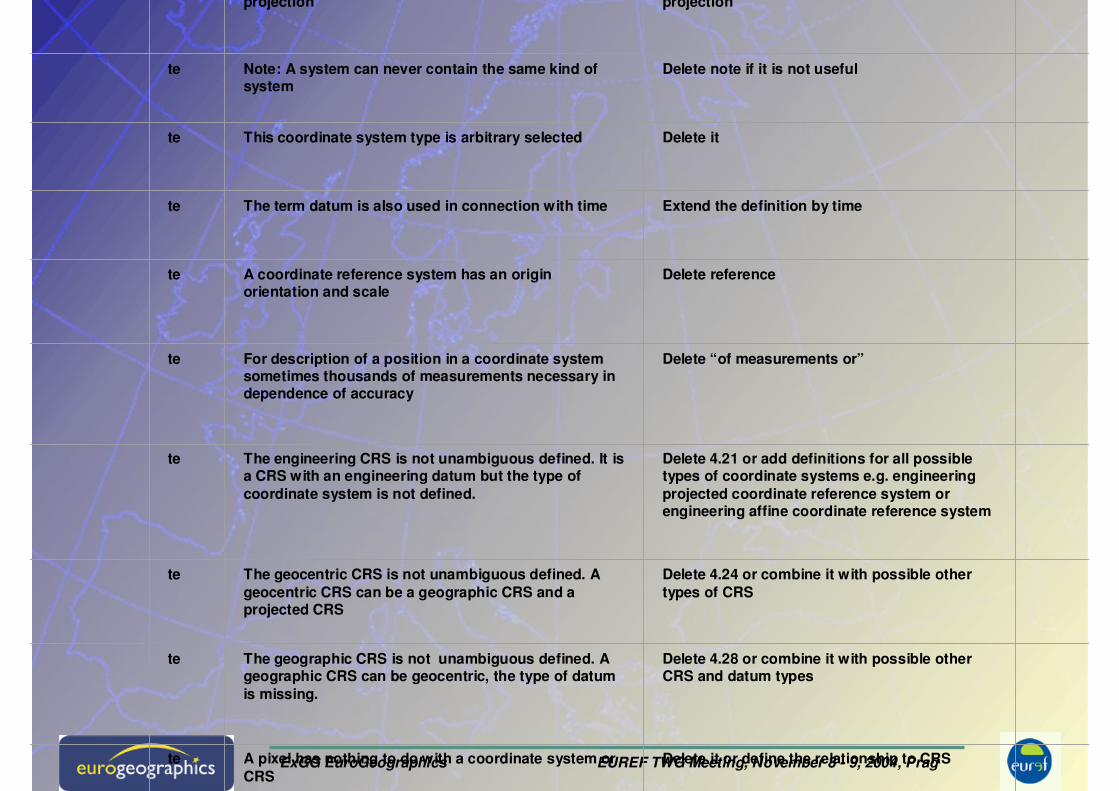
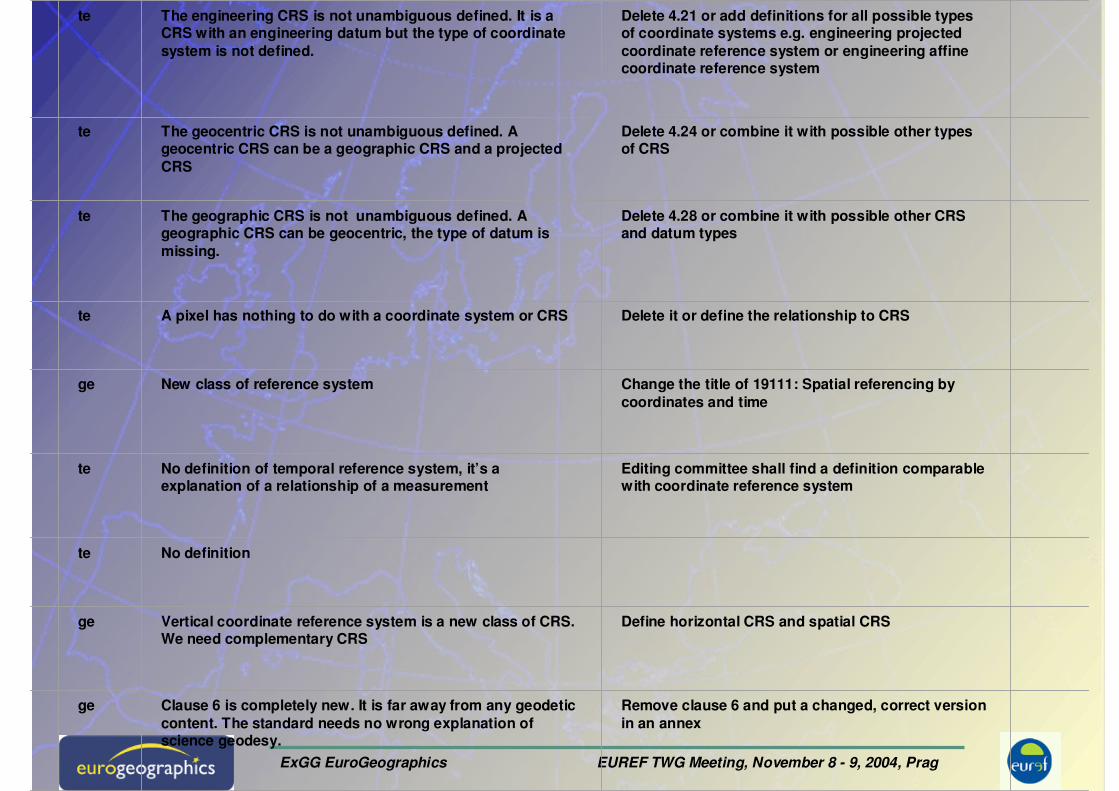
te The engineering CRS is not unambiguous defined. It is a CRS with an engineering datum but the type of coordinate system is not defined.
Delete 4.21 or add definitions for all possible types of coordinate systems e.g. engineering projected coordinate reference system or engineering affine coordinate reference system
te The geocentric CRS is not unambiguous defined. A geocentric CRS can be a geographic CRS and a projected CRS
Delete 4.24 or combine it with possible other types of CRS
te The geographic CRS is not unambiguous defined. A geographic CRS can be geocentric, the type of datum is missing.
Delete 4.28 or combine it with possible other CRS and datum types
te A pixel has nothing to do with a coordinate system or CRS
Delete it or define the relationship to CRS
ExGG EuroGeographics EUREF TWG Meeting, November 8 - 9, 2004, Prag
te The engineering CRS is not unambiguous defined. It is a CRS with an engineering datum but the type of coordinate system is not defined.
Delete 4.21 or add definitions for all possible types of coordinate systems e.g. engineering projected coordinate reference system or engineering affinecoordinate reference system
te The geocentric CRS is not unambiguous defined. A geocentric CRS can be a geographic CRS and a projected CRS
Delete 4.24 or combine it with possible other types of CRS
te The geographic CRS is not unambiguous defined. A geographic CRS can be geocentric, the type of datum is missing.
Delete 4.28 or combine it with possible other CRS and datum types
te A pixel has nothing to do with a coordinate system or CRS Delete it or define the relationship to CRS
ge New class of reference system Change the title of 19111: Spatial referencing by coordinates and time
te No definition of temporal reference system, it’s a explanation of a relationship of a measurement
Editing committee shall find a definition comparable with coordinate reference system
te No definition
ge Vertical coordinate reference system is a new class of CRS. We need complementary CRS
Define horizontal CRS and spatial CRS
ge Clause 6 is completely new. It is far away from any geodetic content. The standard needs no wrong explanation of science geodesy.
Remove clause 6 and put a changed, correct version in an annex
ExGG EuroGeographics EUREF TWG Meeting, November 8 - 9, 2004, Prag
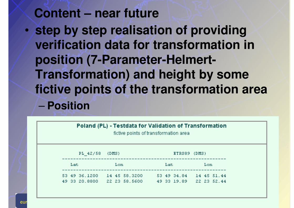
Content – near future• step by step realisation of providing
verification data for transformation in position (7-Parameter-Helmert-Transformation) and height by some fictive points of the transformation area– Position
ExGG EuroGeographics EUREF TWG Meeting, November 8 - 9, 2004, Prag
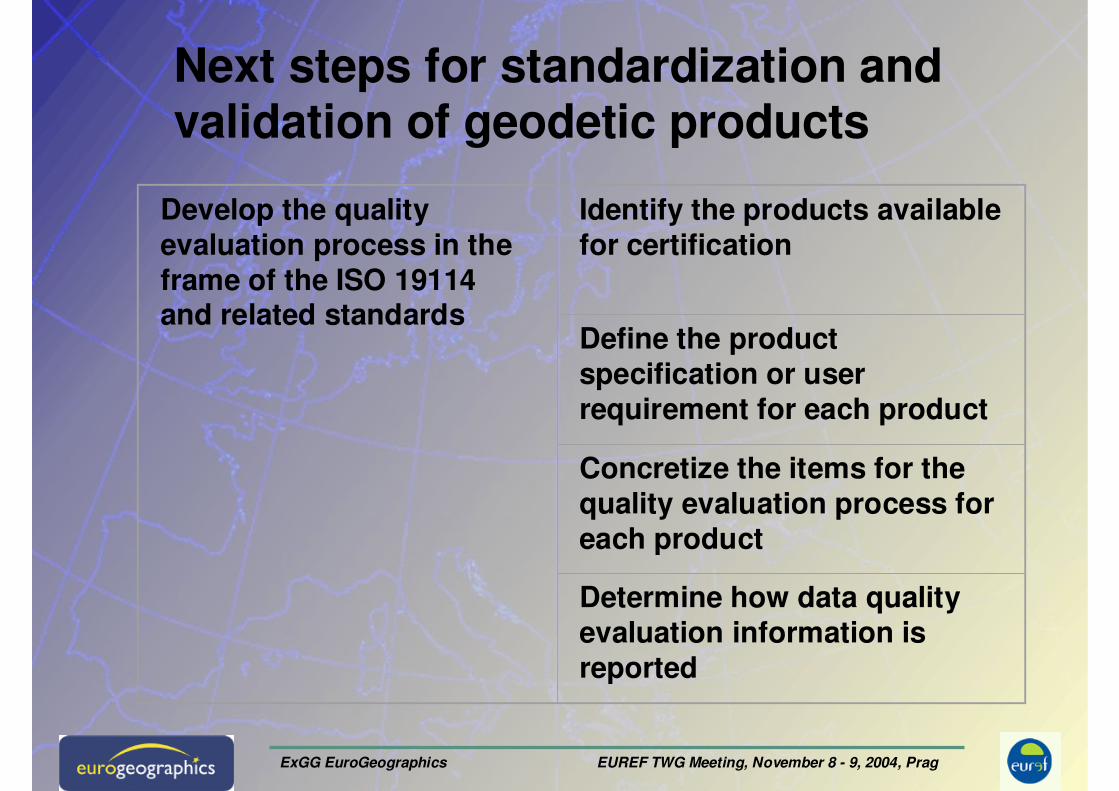
Next steps for standardization and validation of geodetic products
Develop the quality evaluation process in the frame of the ISO 19114 and related standards
Identify the products available for certification
Define the product specification or user requirement for each product
Concretize the items for the quality evaluation process for each product
Determine how data quality evaluation information is reported
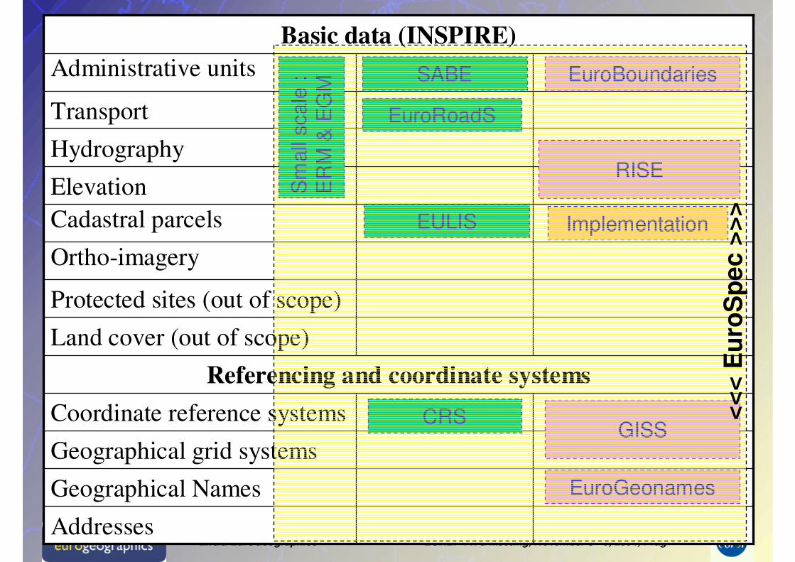
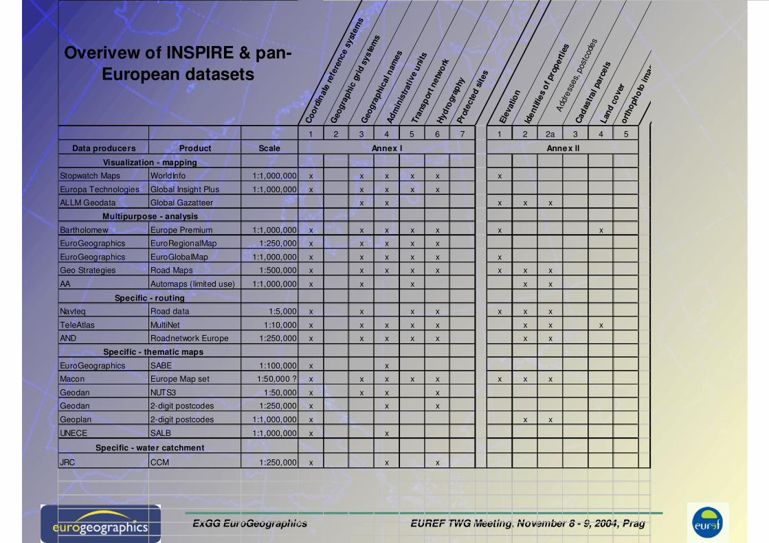
ExGG EuroGeographics EUREF TWG Meeting, November 8 - 9, 2004, PragAddresses
Geographical Names
Geographical grid systems
CRSCoordinate reference systems
Referencing and coordinate systems
Land cover (out of scope)
Protected sites (out of scope)
Ortho-imagery
Cadastral parcels
Elevation
Hydrography
Transport
Administrative units
Basic data (INSPIRE)
Sm
all
scale
:
ER
M &
EG
M
SABE
CRS
EuroBoundaries
RISE
GISS
EuroGeonames
EuroRoadS
ImplementationEULIS
<<
< E
uro
Sp
ec>
>>
ExGG EuroGeographics EUREF TWG Meeting, November 8 - 9, 2004, Prag
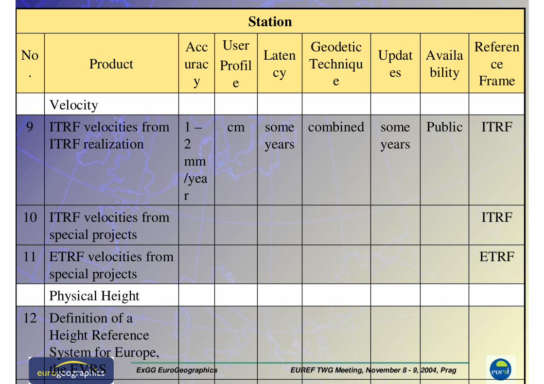
Product Catalogue
UELN13
Definition of a
Height Reference
System for Europe,
the EVRS
12
ETRF
ITRF
ITRF
Referen
ce
Frame
combined
Geodetic
Techniqu
e
some
years
Laten
cy
Physical Height
Station
ETRF velocities from
special projects
11
ITRF velocities from
special projects
10
Publicsome
years
cm1 –
2
mm
/yea
r
ITRF velocities from
ITRF realization
9
Velocity
Availa
bility
Updat
es
User
Profil
e
Acc
urac
y
ProductNo
.
ExGG EuroGeographics EUREF TWG Meeting, November 8 - 9, 2004, Prag
• The main project’s objective is to create ‘EuroBoundaries’, the Definitive European National Boundaries, as a database. This would cover at least the EU, ideally the whole European continent (40+ countries).
• The ‘EuroBoundaries’ DB would be of the highest available accuracy, the target being an accuracy of 1 meter or better. However, resolution requirements must be flexible in terms of accuracy, in order to be consistent with actual data availability.
• The boundary data model shall include the boundary marks, the boundary line and topographic features associated with the boundary. Each point or segment would be attributed (‘metadated’), in terms of providing information about the source of the data, the estimated accuracy, the time-stamp, a unique identifier, status (disputed, jointly defined, …).
• All features and objects will be given ETRS89 co-ordinates, and possibly other co-ordinates in the official national system(s).
EuroBoundaries
ExGG EuroGeographics EUREF TWG Meeting, November 8 - 9, 2004, Prag
Letter to 41 of 47 members of EG Sept. 2004
Contents/Respond:• Terms of reference and a working plan (information)• Asking to confirm the present memberships of ExGG• Inviting the EG members to nominate new ExGG
membersNomination of:Dimitrios Delikaraoglou GreeceEdmandas Sleiteris LithuaniaMaria Ovdii MoldovaKlobušiak, Matej Slovak RepublicYavuz Selim ŞENGÜN Turkey
• Provide missing information for CRS-EU meta data base and confirmation of existing data
Two answers
ExGG EuroGeographics EUREF TWG Meeting, November 8 - 9, 2004, Prag
Coo
rdin
ate
refe
renc
e sy
stem
s
Geo
grap
hic
grid
sys
tem
s
Geo
grap
hica
l nam
esA
dmin
istr
ativ
e u
nits
Tran
spor
t net
wo
rkH
ydro
grap
hyPr
otec
ted
site
s
Elev
atio
nId
entif
ies
of p
rope
rtie
s
A
ddre
sses,
post
code
s
Cad
astr
al p
arce
lsLa
nd c
ove
ror
thop
hoto
imag
es
Overivew of INSPIRE & pan-European datasets
1 2 3 4 5 6 7 1 2 2a 3 4 5
Data producers Product Scale
Stopwatch Maps WorldInfo 1:1,000,000 x x x x x x
Europa Technologies Global Insight Plus 1:1,000,000 x x x x x
ALLM Geodata Global Gazatteer x x x x x
Bartholomew Europe Premium 1:1,000,000 x x x x x x x
EuroGeographics EuroRegionalMap 1:250,000 x x x x x
EuroGeographics EuroGlobalMap 1:1,000,000 x x x x x x
Geo Strategies Road Maps 1:500,000 x x x x x x x x
AA Automaps (limited use) 1:1,000,000 x x x x x
Navteq Road data 1:5,000 x x x x x x x
TeleAtlas MultiNet 1:10,000 x x x x x x x x
AND Roadnetwork Europe 1:250,000 x x x x x x x
EuroGeographics SABE 1:100,000 x x
Macon Europe Map set 1:50,000 ? x x x x x x x x
Geodan NUTS3 1:50,000 x x x x
Geodan 2-digit postcodes 1:250,000 x x x
Geoplan 2-digit postcodes 1:1,000,000 x x x
UNECE SALB 1:1,000,000 x x
JRC CCM 1:250,000 x x x
Annex ll
Specific - routing
Multipurpose - analysis
Annex l
Specific - thematic maps
Specific - water catchment
Visualization - mapping
ExGG EuroGeographics EUREF TWG Meeting, November 8 - 9, 2004, Prag
ge The version of ISO/DIS 19111 from 2004-08-02 ISO/TC 211 N1676 includes more than 100 general and technical changes against the valid standard ISO 19111
Change level DIS to CD
ge 4 clauses or annexes are removed or added Change level DIS to CD
ge The scope is extended to spatio-temporal referencing and top merged spatial-temporal reference systems. This new item has an extent of an new work item.
Change level DIS to CD, change the title of the standard 19111
ge The selection of different types of coordinate reference systems (CRS) is arbitrary. E.g. a geocentric CRS can be a geographic CRS and a projected CRS
Remove all new types of definition of CRS or find an general model and decision for selection of CRS
ge Several definitions of sub types of coordinate systems are added without any foundation and mathematical background. There are infinite possibilities for the definition of coordinate systems. The selected one are not consistent.
Remove the definitions
te There is no affine coordinate system, only affine map projection
Change affine coordinate system in affine map projection
te Note: A system can never contain the same kind of system Delete note if it is not useful
te This coordinate system type is arbitrary selected Delete it
te The term datum is also used in connection with time Extend the definition by time
Comments to revised ISO 19111 from IAG (liaison)