Contribution de l'Espagne à la - IHO · Contribution de l'Espagne à la 8ème Conférence CHAtO...
21
EAtHC8-8D Contribution de l'Espagne à la 8 ème Conférence CHAtO Spanish Contribution to the 8 th EAtHC Conference.
Transcript of Contribution de l'Espagne à la - IHO · Contribution de l'Espagne à la 8ème Conférence CHAtO...
EAtHC8-8D
Contribution de l'Espagne à la 8ème Conférence CHAtO
Spanish Contribution to the 8th EAtHC Conference.

1
PART I REVISION OF CONCLUSIONS ADOPTED DURING THE 7TH EAtHC CONFERENCE AT LISBON. Conclusion No 1 Conclusion No 2 Conclusion No 3 Conclusion No 4 Conclusion No 5 Conclusion No 6 Conclusion No 7 Conclusion No 8 Conclusion No 9 Conclusion No 10 Conclusion No 11 Conclusion No 12
No action required. Spain is not participating in that Working Group. Spain is currently a member of one RENC. It has been taken into account. There are contacts with the EAtHC representative. No action required. It has been taken into account. No action required. A list of private companies is available in the Spanish contribution. There is a proposal from the CHATINTCHART Co-ordinator (France). Please find a similar proposal in the Spanish contribution. The problem of the lack of co-operation between existing RENCs has been dealt with at the IC-ENC Steering Committee. There are fluent relations with the NAVAREA II co-ordinator.

2
PART II 2.1 NEW TECHNIQUES AND EQUIPMENT 2.1.1 Hydrography: Since 1995 the Instituto Hidrográfico de la Marina has been carrying out hydrographic surveys using multi-beam echo sounders in the Spanish EEZ one month a year, through Hydrographic Commissions on board RV “Hespérides”. From 1995 to 1997 survey works were focused in waters around the Balearic Islands within the Mediterranean Sea project, for 40556 km. In September 1998 it was started the survey of the Canary Island, covering 100000 km overall in 1998, 1999 and 2000. In 2001, 2002 and 2003 there were surveys in the area of Galicia. Data captured by EM 12 and EM 1002 sounders are processed at the IHM since 1997, so as to obtain Bathymetric Maps at scale 1:200000 as well as fair sheets for cartographic updating. Software used for this process was HIPS (bathymetry) and SIPS (reflectivity) by Caris Universal Ltd, at we consider that up to date is fully covers our requirement for cartographic production. We should note that according to out experience, workstations for processing must be high performance hardware, so that the work is seamless and speedy (always considering the slowness intrinsic to high accuracy processing). On 27 February 2004 the Spanish Navy received the second hydrographic small craft, named “Escandallo”. This small craft is similar to previous “Astrolabio”, and comes fitted with EA 3000D echosounder. The following have been surveyed by the “Astrolabio” small craft using multi-beam echo sounder: - Entrance channel, ports and anchorages in Cádiz, Zona Franca and Estación Naval de Puntales. - Rota Navy Base. - Entrance, anchorage and port of Ceuta. - Entrance and ria of Huelva. - Entrance, anchorage and port of Ferrol. The “Escandallo” small craft has completed the entrance, anchorage and port of A Coruña. Both small crafts are expected to continue with the multi-beam surveying of entrances and main ports of the Iberian Peninsula. HV Pollux has been decommissioned, and on 10 September 2004 HV Castor will be likewise decommissioned.

3
A new deep water (up to 5000 deep) multi-beam echo sounder EM-300 is being fitted onboard HV Tofiño. The calibration and final testing of the equipment is scheduled for September 2004, and after this calibration the aforementioned multi-beam echo sounder will start surveying the waters of the Straits of Gibraltar. Please find attached figures depicting the status of hydrographic surveys.

4
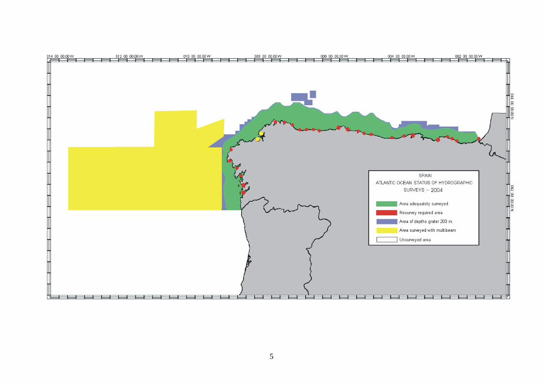
5
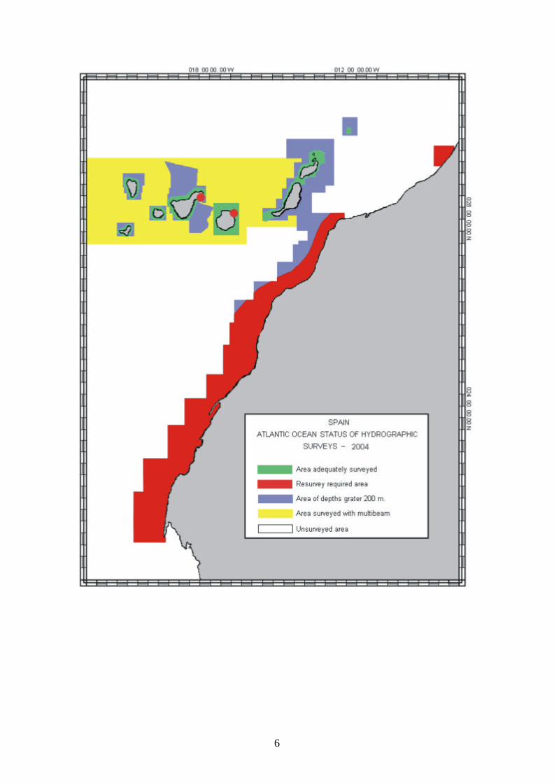
6

7

8
2.1.2 Geodesy and Photogrammetry: The replacement of the old photogrammetric analogical plotters by digital stations is being accomplished. So far, two digital stations are now completely operative, and a third one is expected to be received shortly. A new geodetic tools software has been built recently and is now being tested. It is to replace the old program which ran in DOS. This new program allows to solve several geodetic problems, such as transformation between different datums and projections, field surveying management and connection to field marks databases.

9
2.2 TECHNICAL ASSISTANCE, TRAINING AND CO-OPERATION A collaboration project with the Royal Moroccan Navy is scheduled for 2005, to continue with joint surveys in Nautical Chart 105 (INT 3150) started on 2001. Spain was designated as leader of the Pilot Project within the collaborations programmed during the “Sea Power Symposium”, held in Venice in 1999.
10
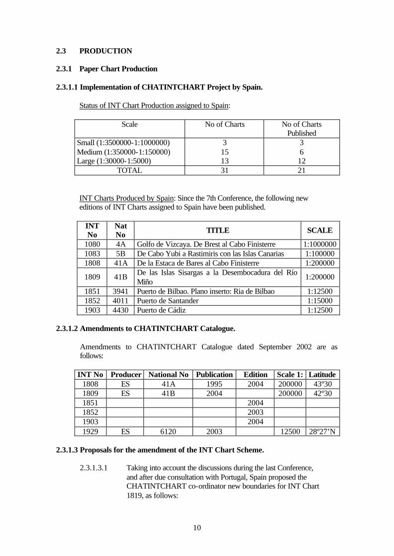
2.3 PRODUCTION 2.3.1 Paper Chart Production 2.3.1.1 Implementation of CHATINTCHART Project by Spain. Status of INT Chart Production assigned to Spain:
Scale No of Charts No of Charts Published
Small (1:3500000-1:1000000) Medium (1:350000-1:150000) Large (1:30000-1:5000)
3 15 13
3 6 12
TOTAL 31 21 INT Charts Produced by Spain: Since the 7th Conference, the following new editions of INT Charts assigned to Spain have been published.
INT No
Nat No TITLE SCALE
1080 4A Golfo de Vizcaya. De Brest al Cabo Finisterre 1:1000000 1083 5B De Cabo Yubi a Rastimiris con las Islas Canarias 1:100000 1808 41A De la Estaca de Bares al Cabo Finisterre 1:200000
1809 41B De las Islas Sisargas a la Desembocadura del Río Miño
1:200000
1851 3941 Puerto de Bilbao. Plano inserto: Ria de Bilbao 1:12500 1852 4011 Puerto de Santander 1:15000 1903 4430 Puerto de Cádiz 1:12500
2.3.1.2 Amendments to CHATINTCHART Catalogue.
Amendments to CHATINTCHART Catalogue dated September 2002 are as follows:
INT No Producer National No Publication Edition Scale 1: Latitude 1808 ES 41A 1995 2004 200000 43º30 1809 ES 41B 2004 200000 42º30 1851 2004 1852 2003 1903 2004 1929 ES 6120 2003 12500 28º27’N
2.3.1.3 Proposals for the amendment of the INT Chart Scheme. 2.3.1.3.1 Taking into account the discussions during the last Conference, and after due consultation with Portugal, Spain proposed the CHATINTCHART co-ordinator new boundaries for INT Chart 1819, as follows:
11
INT No Nat No Scale 1: N Limit S Limit E Limit W Limit
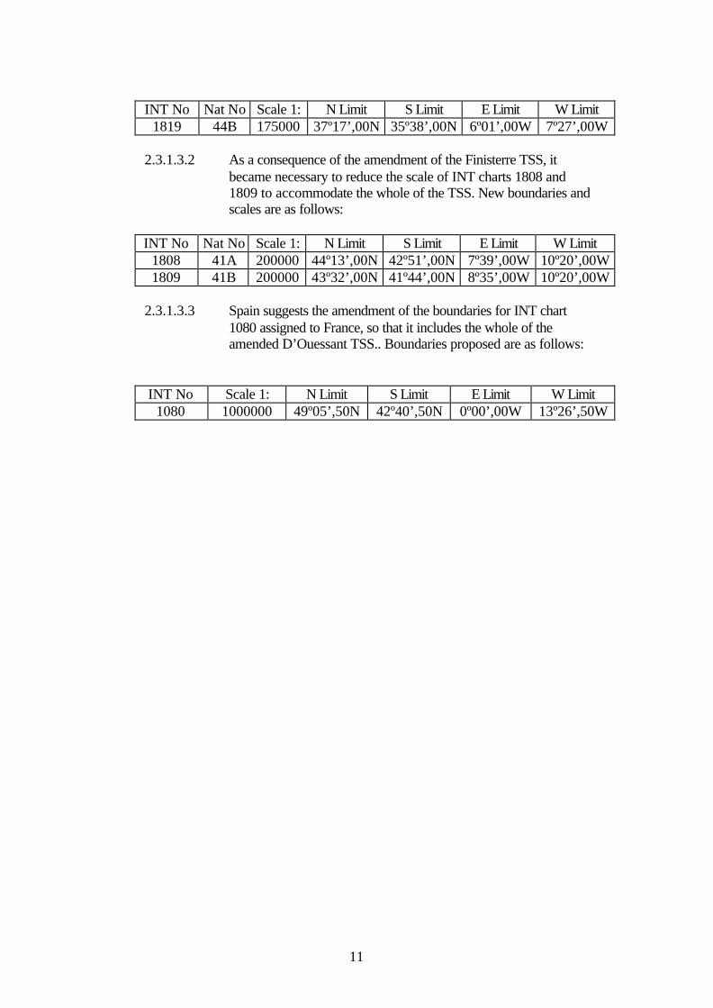
1819 44B 175000 37º17’,00N 35º38’,00N 6º01’,00W 7º27’,00W 2.3.1.3.2 As a consequence of the amendment of the Finisterre TSS, it became necessary to reduce the scale of INT charts 1808 and 1809 to accommodate the whole of the TSS. New boundaries and scales are as follows:
INT No Nat No Scale 1: N Limit S Limit E Limit W Limit 1808 41A 200000 44º13’,00N 42º51’,00N 7º39’,00W 10º20’,00W 1809 41B 200000 43º32’,00N 41º44’,00N 8º35’,00W 10º20’,00W
2.3.1.3.3 Spain suggests the amendment of the boundaries for INT chart 1080 assigned to France, so that it includes the whole of the amended D’Ouessant TSS.. Boundaries proposed are as follows:
INT No Scale 1: N Limit S Limit E Limit W Limit 1080 1000000 49º05’,50N 42º40’,50N 0º00’,00W 13º26’,50W

12
2.3.2. Digital Chart Production.
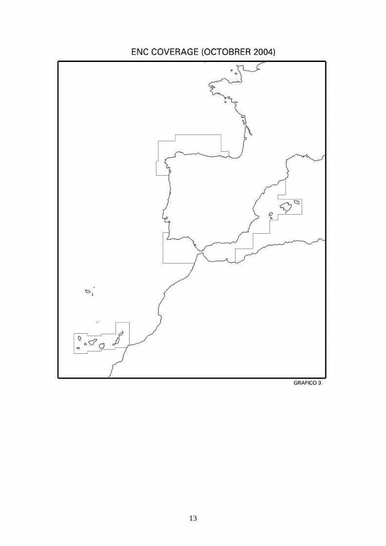
2.3.2.1 ENC Cartography. ENC Production
Current status of Spanish (Atlantic and Mediterranean) ENC production is as follows:
Purpose 1 Purpose 2 Purpose 3 Purpose 4 Purpose 5 Overall
- 3 16 33 37 89
Distribution ENCs and updates are made available to mariners through the International Centre for ENC. For further information please check www.ic-enc.org
13

14
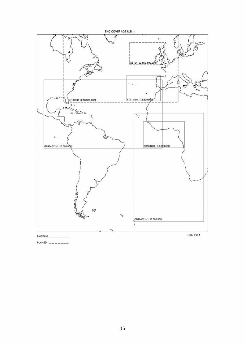
2.3.3. Small – Scale ENC The need for small scale ENCs to help in planning routes has been stated repeatedly in the past. Currently there are already small scale ENCs produced by United Kingdom and Portugal that cover the area of this Hydrographic Commission. Considering the above and from the WEND Principles and the Guidelines for the Establishment of ENC Production Boundaries, it would be convenient the establishment and assignation of small scale ENC production boundaries. Navigational Purpose 1. Currently there are the following ENCs Navigational Purpose 1: (see attached graphic)
Charts Produced INT Chart Reference Scale GB 104012 INT 12 1:10000000 PT 111101 1:2500000 GB 104021 INT 21 1:10000000 GB 104209 INT 209 1:3500000
Charts Planned INT Chart Reference Scale
GB 104011 INT 11 1:10000000 GB 104102 INT 102 1:3500000
This situation can be considered as satisfactory, although it could be improved by adding cells at bigger scales within the selfsame navigational purpose. Navigational Purpose 2. The CHATINTCHART scheme lists the series of charts 1080, 1081, 1082, 1083, 1084, 1085, 2086, 2087, 2088 and 2089, with scales at 1:1000000 or 1:1100000. Considering the recommendations on consistency in IHB Circular Letter No 47/2004, these charts should be at Compilation Scale 700000 and included under Usage Band 2. Consequently, it is proposed the adoption of this scheme for ENC production; Usage Band 2, with boundaries similar to those assigned in the attached graphic.
15
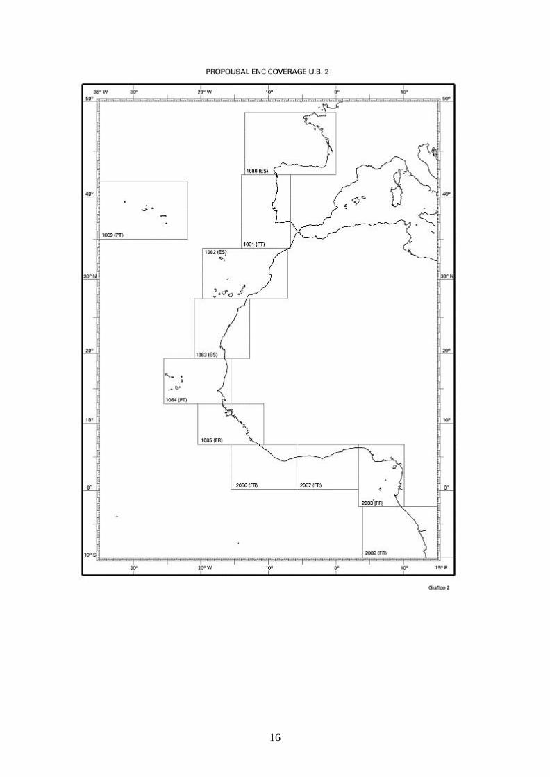
16

17
2.4 OCEANOGRAPHY Digital Tide Tables Tide tables in digital format have been produced. Also, permanent tidemeters established at the ports of Pasajes and Burela have been removed. New equipment for oceanographic data acquisition A rosette for real-time CTD has been purchased, as well a fluorometer for Chlorophyll measurements and a PAR radiometer to compute light extinguishing curves. Bathitermographic tracings have been inputted into the new Oceanographic System Information (SIO) Database, both from Fleet units and from data captured in several oceanographic cruises using CTD, Sound Velocity Profilers and XBT. Processing of multi-beam data using CARIS HIPS & CARIS SIPS Digital processing of data captured by the sidescan sonar Klein 2000 is continued. The use of CARIS SIPS processing software allows for an output which is standardized and compatible with the output from other branches of the Instituto Hidrográfico, as well as the access to shared cartographic tools.

18
2.5 MARITIME SAFETY INFORMATION Current situation of the broadcasting of Maritime Safety Information (MSI) can be summarized as follows: Notices to Mariners : - Co-ordinator: IHM acts as the Co-ordinator for coastal and local radio warnings. - Means: - NAVTEX stations (under SASEMAR) - OM and VHF stations (under TELEFONICA) Any information that the Instituto Hidrográfico de la Marina, in its capacity as National Co-ordinator for Radio Navigational Warnings, considers as relevant for vessels sailing the Navarea II Area and French coastal waters is submitted via fax to FRANAUT (Navarea II Co-ordinator). Conversely, FRANAUT provides us as ETABHYDROC BREST via telex over the SACOMAR network any maritime safety information relevant for Spanish coastal waters and the Navarea III coverage area. Consequently, there is a fluid exchange of information maintained between both Co-ordinators. Likewise, if the Instituto Hidrográfico learns of any event of relevance for maritime safety in seas of another country within Navarea II Zone, both the country and the Navarea II Co-ordinator are duly informed. SAR: - Co-ordinator: SASEMAR through its National Centre and Zonal, Regional and Local Centres. - Means: NAVTEX stations and broadcasting stations of SASEMAR Centres, as well as OM VHF TELEFONICA Coastal Stations.

19
2.6 SCHOOLING AND TRAINING 2.6.1 Technical Assistance and Training The School of Hydrography, based in the Instituto Hidrográfico, is tasked with the training of Navy hydrographic staff of all ranks as stated in chapter 18 of the OMD no 132/82 dated 29 April which approves its Rules. A series of reforms had the School become established in the Instituto Hidrográgico in 1974 to teach both the courses for Hydrographic Surveyor and Specialization for Officers already taught at the Instituto, and the course of Access to the Ranks of Petty Officer and for Sailors previously taught at the Hydrographic Vessel TOFIÑO. Training of hydrographic staff is achieved through different courses of Training and Enhancement on four levels of training, as follows: * Hydrographic Surveying Officer, which enables him to carry out tasks of Technical-Facultative Management at the Instituto Hidrográfico de la Marina. * Specialization in Hydrography for Officers, for them to direct hydrographic surveys on Hydrographic Commissions and Vessels. This course has been acknowledged with category “A” on hydrographic competence in accordance with IHO publication S-47. * Specialization for Petty Officers, technical training to operate systems and equipment on Vessels and at the Instituto Hidrográfico. This course has been acknowledged with category “B” on hydrographic competence in accordance with IHO publication S-47. * Navy staff specialized in Handling and Navigation, for them to carry out auxiliary tasks in hydrographic surveys. Courses taught to Spanish Officers and Petty Officers are regularly attended by staff from foreign navies under the “Collaboration Program with Foreign Countries in Military Training” of the Spanish Ministry of Defense. Also, workshops are available for personnel from other areas (mainly personnel on board warships), that is workshops on “Trisponder”, “Differential GPS”, “Side Scan Sonar” and “Acoustics and Sound Propagation”.

20
2.7. COPYRIGHT In compliance with Conclusion no 9 of the 7th EAtHC Conference, the list of companies which have signed agreements with the IHM are the following: - Transas Marine. - C-Map. - Garmin.


![La Lauseta : almanach du patriote latin pour l'Espagne, la France, [...] 1877](https://static.fdocuments.fr/doc/165x107/577cda551a28ab9e78a56781/la-lauseta-almanach-du-patriote-latin-pour-lespagne-la-france-.jpg)