Bibliographie des Enseignants et Chercheurs de l'UAC
29
Transcript of Bibliographie des Enseignants et Chercheurs de l'UAC


Gilbert T. LALEYE. et al.
Int. J. Biol. Sci.
(Onli RESEARCH PAPER
Seasonal variability of thedrilling artesian common Zagnanado and Zogbodomey in central Benin .
Gilbert Tite LALЀYÊ 1 *, Léonce Firmin DOVONONHOUSSOU
1École Doctorale Pluridisciplinaire "Espaces, Cultures et Développement", Faculté des Lettres, Arts et Sciences Humaines/Université d’Abomey-Calavi(UAC) Courriel : [email protected] 04 BP 848 Cotonou97 53 00 04 2Laboratoire d’Etude et de Recherche en Chimie Appliquée,Calavi(UAC) Courriel: [email protected] 01 BP 315 Cotonou 3Département de Géographie et Aménagement du Territoire (DGAT/UAC) et Centre Béninois de la Recherche Scientifique et Technique (CBRST) ,04 BP 1132 Cotonou 4Laboratoire Pierre Pagney – Climat-Eauet Sciences Humaines/Université d’[email protected] 5Laboratoire de recherche en Biochimie et en Toxicologie de l’Environnement, Département de Biochimie et de Biologie Cellulaire, Faculté de Science et Technique, Université d’AbomeyCourriel: [email protected]
Dynamic Network for Research Works
DNetRW © 2015 http://www.dnetrw.com
International Journal of Biological Sciences (IJBS)
ISSN: 2313(Onli http://www.dne
Vol. 02, No. 02
OPEN ACCESS
Seasonal variability of the quality of water sources and drilling artesian common Zagnanado and Zogbodomey in
Léonce Firmin DOVONON2 ; Thierry Hervé AZONHÊHOUSSOU4 ; Patrick A. EDORH5
"Espaces, Cultures et Développement", Faculté des Lettres, Arts et Sciences
Calavi(UAC) Courriel : [email protected] 04 BP 848 Cotonou
Laboratoire d’Etude et de Recherche en Chimie Appliquée, Ecole Polytechnique d’Abomey-Calavi/ Université d’AbomeyCourriel: [email protected] 01 BP 315 Cotonou
Département de Géographie et Aménagement du Territoire (DGAT/UAC) et Centre Béninois de la Recherche Scientifique et Technique (CBRST) ,04 BP 1132 Cotonou-Bénin
Eau-Écosystèmes-Développement Durable (LACEEDE)/ ", Faculet Sciences Humaines/Université d’Abomey-Calavi(UAC ) BP 1338 Abomey-Calavi-
Laboratoire de recherche en Biochimie et en Toxicologie de l’Environnement, Département de Biochimie et de Biologie Cellulaire, Faculté de Science et Technique, Université d’Abomey- Calavci, 03 BP 0994 Cotonou - Bénin
P a g e | 1
2015
International Journal of Biological Sciences (IJBS)
ISSN: 2313-3740 (Online) http://www.dnetrw.com
2, P. 01-26, 2015
OPEN ACCESS
quality of water sources and drilling artesian common Zagnanado and Zogbodomey in
Thierry Hervé AZONHÊ3 Christophe S.
"Espaces, Cultures et Développement", Faculté des Lettres, Arts et Sciences Calavi(UAC) Courriel : [email protected] 04 BP 848 Cotonou-Benin : cell 229
Calavi/ Université d’Abomey-
Département de Géographie et Aménagement du Territoire (DGAT/UAC) et Centre Béninois de la Recherche
Développement Durable (LACEEDE)/ ", Faculté des Lettres, Arts -Benin. Courriel :
Laboratoire de recherche en Biochimie et en Toxicologie de l’Environnement, Département de Biochimie et de Biologie Bénin
Gilbert T. LALEYE. et al. P a g e | 2
Int. J. Biol. Sci. 2015
DNetRW © 2015 http://www.dnetrw.com
Keywords: artesian water sources; water artesian wells; hydrochemistry; Zagnanado-Zogbodomey
region
Abstract The basins of rivers Ouémé and Zou were selected to better understand the relationships between the waters of artesian springs and artesian water wells in the region Zagnanado and Zogbodomey. From physicochemical analyzes (temperature, pH, electrical conductivity, major cations and anions) on water samples taken from both the artesian springs and artesian wells, the chemical signature of each water system been established. The results show that drilling water has a relatively acidic pH. Against by the sources have a pH close to neutrality. Of the rainy season to the dry season, is observed dynamics of geochemical facies in the waters of artesian wells, while it remains unchanged for almost all water artesian springs. . The waters of artesian springs have a chemical signature similar to that of artesian wells with an overlay that varies according to climatic events and fracturing phenomena, which allow the rapid transport of water through the bedrock. This reflects the existence of favorable conditions to trade flows between the river system and the continuous aquifers. Corresponding Author’s Email: [email protected]
Gilbert T. LALEYE. et al. P a g e | 3
Int. J. Biol. Sci. 2015
DNetRW © 2015 http://www.dnetrw.com
I.INTRODUCTION
In both municipalities, the average rate of
access to the water distribution network
(SONEB) barely reaches 40% (BIA 2012).
Groundwater is the main source of drinking
water for people not connected to the
drinking water network (WETHE et al.,
2003). However, comprehensive
hydrochemical characteristics are unknown.
Hence the need for more research on the
quality and functioning of the most stressed
water resources today. This study aims to
improve knowledge on water sources and
drilling artesian most exploited in the
middle of study. From physicochemical
analyzes (temperature, pH, electrical
conductivity, major cations and anions) on
water samples, the chemical signature of
each water system was established. As part
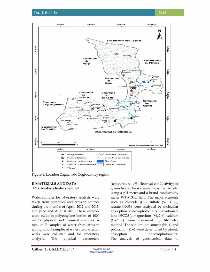
of the study consists of Commons
Zagnanado and Zogbodomey in Benin is
between 6 ° 56 'and 7 ° 30' North latitude
and 2 ° 05 'and 2 25'de East longitude and
covers an area of 1575 km² [Figure 1]. The
presence of low topographic areas (valleys,
depressions) and the captive nature of the
aquifer Turonian-Coniacian and Eo-
Paleocene promote groundwater seepage at
several points in the two municipalities.
Artesian springs and development artesian
wells thus created an important source of
supply for the populations of the two towns.
The relief of the town Zogbodomey is
characterized by a plain and a plateau that
covers 3/5 of the area of the town, with an
elevation of about 137 m between the
highest point in the northern part of the
town and the lowest point on the south-
eastern tip (BIA 2012). This tray is located
north of the depression of the Lama whose
average altitude is 50 m and width ranging
from 5 km west 25 km to the east. Thus, the
slopes are generally there less than 5%. The
relief of the town Zagnanado is
characterized by plains and plateaus causing
an elevation of about 270 m between the
highest point in the northern part of the
town and the lowest point in the southern
tip. The slopes are generally there for less
than 5%, but nearly 4% of the area is
characterized by slopes with a gradient
greater than 15% (SDAC, 2012).
The rainfall in the two municipalities of sub-
equatorial. The analysis of rainfall and
temperature in Bohicon station and
Zagnanado (1980-2012) reveals that the
monthly averages are respectively 1132.9
mm and 1064 mm and 28 ° C.
Gilbert T. LALEYE. et al. P a g e | 4
Int. J. Biol. Sci. 2015
DNetRW © 2015 http://www.dnetrw.com
Figure 1: Location-Zagnanado Zogbodomey region
II MATERIALS AND DATA 2.1 -: Analysis hydro chemical
Water samples for laboratory analysis were
taken from boreholes and artesian sources
during the months of April, 2012 and 2013,
and June and August 2013. These samples
were made in polyethylene bottles of 1000
ml for physical and chemical analyzes. A
total of 7 samples of water from artesian
springs and 5 samples of water from artesian
wells were collected and for laboratory
analysis. The physical parameters
(temperature, pH, electrical conductivity) of
groundwater books were measured in situ
using a pH meter and a brand conductivity
meter WTW 340i field. The major elements
such as chloride (Cl-), sulfate (SO 4 2-),
nitrate (NO3) were analyzed by molecular
absorption spectrophotometry. Bicarbonate
ions (HCO3-), magnesium (Mg2 +), calcium
(Ca2 +) were measured by titrimetry
method. The sodium ion content (Na +) and
potassium (K +) were determined by atomic
absorption spectrophotometer.
The analysis of geochemical data to
Gilbert T. LALEYE. et al. P a g e | 5
Int. J. Biol. Sci. 2015
DNetRW © 2015 http://www.dnetrw.com
determine the processes and sources of
mineralization of groundwater is heavily
based on statistical techniques (Guler et al.,
2002). It is in our case the principal
component analysis (PCA).
2.2-: Principal Component Analysis (PCA) But alone does not allow statistical analysis
to identify the process and sources of
mineralization. We used the ion ratios to
complete our study. The Piper diagram was
used to define the chemical profile of the
water.
PCA is a statistical techniques increasingly
employed on several variables in order to
identify the factors controlling the variability
of geochemical data. The CPA helps to
simplify and organize a wide variety of data.
It provides useful generalizations that lead
to significant insights. The advantage of PCR
is that all the variables in a series of data can
be performed simultaneously, and much
more easily than is possible with traditional
conventional methods of comparison of the
variables in the diagrams in two dimensions
(x, y) or in three dimensions (x, y, z). Most
statistical techniques requires a normal
distribution of data, but this requirement
does not relate to the CPA because this
technique is based exclusively on correlation
matrices or covariances. Data on
groundwater rarely normally distributed.
The purpose of the ACP is to identify the
variables that define the most mineralization
of water, the way the ions group together
and the different groups that emerge. In our
case, the explanatory variables of the groups
are the variables used previously for ACP
.The projection of individuals in a factorial
design offers the advantage of
understanding the similarity or the contrast
between the characteristics of individuals
and the sources of their variability (Canceill
M. and Landreau A., 1978). The applicability
of this exploratory technique is based on the
choice of the number of axes representing
the maximum inertia kept with the
minimum possible factors. In general, the
PCR a region is only valid when the factorial
study splans retain at least 70% of
information (Faillat 1986; Biemi 1992). Below
this limit, we consider that the study of the
region did not take into account a large
amount of information. Multivariate
analysis was performed using the software
SPSS 17.0, XL STAT. Version 2012. Results of
the study are presented through the binary
diagrams, spatio-temporal analysis and
statistical processing.
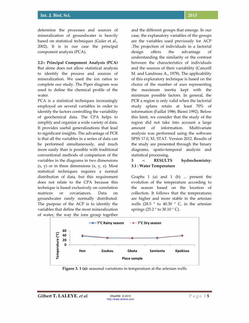
3 -: RESULTS hydrochemistry: 3.1 : Water Temperature Graphs 1 (a) and 1 (b) ... present the
evolution of the temperature according to
the season based on the location of
collection. It follows that the temperatures
are higher and more stable in the artesian
wells (28.5 ° to 40.30 ° C, in the artesian
springs (25.2 ° to 30.10 ° C).
Figure 3. 1 (a): seasonal variations in temperature at the artesian wells
0
20
40
60
Hon Zoukou Gbata Samionta Kpokissa
Te
mp
era
ture
(°C
)
Place sample
T°C Rainy season T°C Dry season
Gilbert T. LALEYE. et al. P a g e | 6
Int. J. Biol. Sci. 2015
DNetRW © 2015 http://www.dnetrw.com
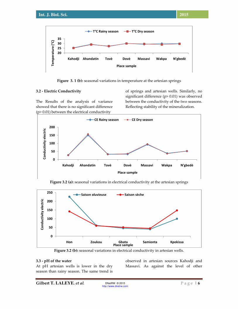
Figure 3. 1 (b): seasonal variations in temperature at the artesian springs
3.2 - Electric Conductivity
The Results of the analysis of variance
showed that there is no significant difference
(p> 0.01) between the electrical conductivity
of springs and artesian wells. Similarly, no
significant difference (p> 0.01) was observed
between the conductivity of the two seasons.
Reflecting stability of the mineralization.
Figure 3.2 (a): seasonal variations in electrical conductivity at the artesian springs
Figure 3.2 (b): seasonal variations in electrical conductivity in artesian wells.
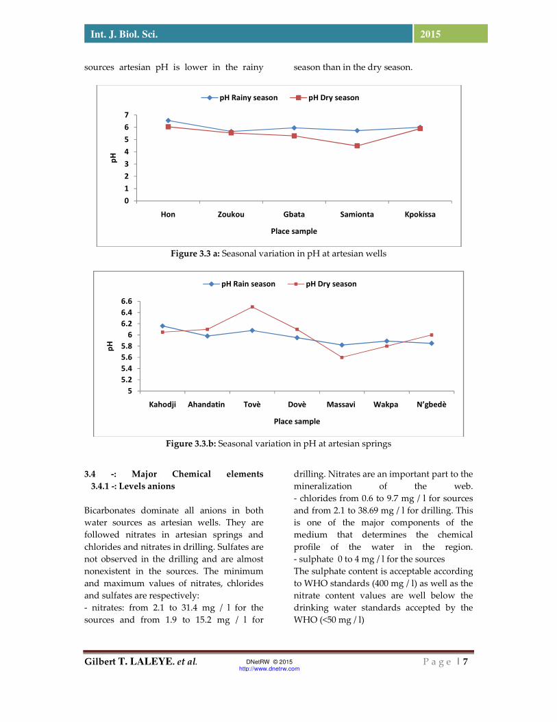
3.3 - pH of the water At pH artesian wells is lower in the dry
season than rainy season. The same trend is
observed in artesian sources Kahodji and
Massavi. As against the level of other
20
25
30
35
Kahodji Ahandatin Tovè Dovè Massavi Wakpa N’gbedè
Te
mp
era
ture
(°C
)
Place sample
T°C Rainy season T°C Dry season
0
50
100
150
200
Kahodji Ahandatin Tovè Dovè Massavi Wakpa N’gbedè
Co
nd
uct
ivit
y e
lect
ric
Place sample
CE Rainy season CE Dry season
0
50
100
150
200
250
Hon Zoukou Gbata Samionta Kpokissa
Co
nd
uct
ivit
y e
lect
ric
Place sample
Saison pluvieuse Saison sèche
Gilbert T. LALEYE. et al. P a g e | 7
Int. J. Biol. Sci. 2015
DNetRW © 2015 http://www.dnetrw.com
sources artesian pH is lower in the rainy season than in the dry season.
Figure 3.3 a: Seasonal variation in pH at artesian wells
Figure 3.3.b: Seasonal variation in pH at artesian springs
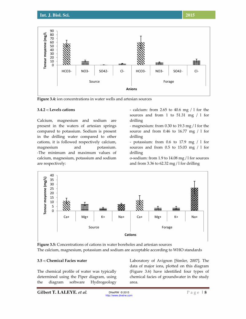
3.4 -: Major Chemical elements 3.4.1 -: Levels anions Bicarbonates dominate all anions in both
water sources as artesian wells. They are
followed nitrates in artesian springs and
chlorides and nitrates in drilling. Sulfates are
not observed in the drilling and are almost
nonexistent in the sources. The minimum
and maximum values of nitrates, chlorides
and sulfates are respectively:
- nitrates: from 2.1 to 31.4 mg / l for the
sources and from 1.9 to 15.2 mg / l for
drilling. Nitrates are an important part to the
mineralization of the web.
- chlorides from 0.6 to 9.7 mg / l for sources
and from 2.1 to 38.69 mg / l for drilling. This
is one of the major components of the
medium that determines the chemical
profile of the water in the region.
- sulphate 0 to 4 mg / l for the sources
The sulphate content is acceptable according
to WHO standards (400 mg / l) as well as the
nitrate content values are well below the
drinking water standards accepted by the
WHO (<50 mg / l)
0
1
2
3
4
5
6
7
Hon Zoukou Gbata Samionta Kpokissa
pH
Place sample
pH Rainy season pH Dry season
5
5.2
5.4
5.6
5.8
6
6.2
6.4
6.6
Kahodji Ahandatin Tovè Dovè Massavi Wakpa N’gbedè
pH
Place sample
pH Rain season pH Dry season
Gilbert T. LALEYE. et al. P a g e | 8
Int. J. Biol. Sci. 2015
DNetRW © 2015 http://www.dnetrw.com
Figure 3.4: ion concentrations in water wells and artesian sources
3.4.2 -: Levels cations
Calcium, magnesium and sodium are
present in the waters of artesian springs
compared to potassium. Sodium is present
in the drilling water compared to other
cations, it is followed respectively calcium,
magnesium and potassium.
-The minimum and maximum values of
calcium, magnesium, potassium and sodium
are respectively:
- calcium: from 2.65 to 40.6 mg / l for the
sources and from 1 to 51.31 mg / l for
drilling
- magnesium: from 0.30 to 19.3 mg / l for the
source and from 0.46 to 16.77 mg / l for
drilling
- potassium: from 0.6 to 17.9 mg / l for
sources and from 0.5 to 15.03 mg / l for
drilling
o-sodium: from 1.9 to 14.08 mg / l for sources
and from 3.36 to 62.32 mg / l for drilling
Figure 3.5: Concentrations of cations in water boreholes and artesian sources
The calcium, magnesium, potassium and sodium are acceptable according to WHO standards
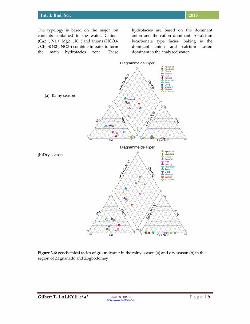
3.5 -: Chemical Facies water The chemical profile of water was typically
determined using the Piper diagram, using
the diagram software Hydrogeology
Laboratory of Avignon [Simler, 2007]. The
data of major ions, plotted on this diagram
(Figure 3.6) have identified four types of
chemical facies of groundwater in the study
area.
0102030405060708090
HCO3- NO3- SO42- Cl- HCO3- NO3- SO42- Cl-
Source Forage
Te
ne
ur
mo
ye
nn
e (
mg
/L
Anions
0
5
10
15
20
25
30
35
40
Ca+ Mg+ K+ Na+ Ca+ Mg+ K+ Na+
Source Forage
Te
ne
ur
mo
ye
nn
e (
mg
/L)
Cations
Gilbert T. LALEYE. et al. P a g e | 9
Int. J. Biol. Sci. 2015
DNetRW © 2015 http://www.dnetrw.com
Diagramme de Piper
Mg
SO
4+Cl+
NO
3
Ca
Na+K
CO
3+HCO
3
Cl+NO3
SO
4
Ca+M
g
0
100 0
100
0100 0 100
0
100 0
100
0 0
100
100
Massavi
KpokissaSamiontaGbataZoukouHonKahodjiAhandatinToveDoveMassaviWakpaN'Gbede
Diagramme de Piper
Mg
SO
4+C
l+N
O3
Ca
Na+K
CO
3+H
CO
3
Cl+NO3
SO
4
Ca+M
g
0
100 0
100
0100 0 100
0
100 0
100
0 0
100
100
KpokissaSamiontaGbataZoukouHonKahodjiAhandatinToveDoveMassaviWakpaN'Gbede
The typology is based on the major ion
contents contained in the water. Cations
(Ca2 +, Na +, Mg2 +, K +) and anions (HCO3-
, Cl-, SO42-, NO3-) combine in pairs to form
the main hydrofacies zone. These
hydrofacies are based on the dominant
anion and the cation dominant: A calcium
bicarbonate type facies, baking is the
dominant anion and calcium cation
dominant in the analyzed water.
(a) Rainy season
(b)Dry season
Figure 3.6: geochemical facies of groundwater in the rainy season (a) and dry season (b) in the
region of Zagnanado and Zogbodomey

Gilbert T. LALEYE. et al. P a g e | 10
Int. J. Biol. Sci. 2015
DNetRW © 2015 http://www.dnetrw.com
Table 3.1: Seasonal geochemical facies of water sources and artesian wells in Zogbodomey and
Zagnanado
Geochemical facies Rainy season Dry season
And chlorinated lime
magnesium
(Cl-Ca-Mg)
- Source de Kahodji
-Forage de Samionta
-Forage de Gbata
- Forage de zoukou
Calcium bicarbonate and
magnesium
(Ca-Mg-HCO3)
- Forage de Hon
- Source de Ahandadin
- Source de N’gèdè
-Source de Massavi
-Source de Dovè
-Source de Wakpa
-Source de Tovè
-Source de Ahandatin
-Source de Dovè
-source de N’gbèdè
-Source de Massavi
-Source de Tovè
-Source de Wakpa
Sodium bicarbonate and
potassium (Na-K-HCO3)
-
Forage de Samionta
-Forage de Kpokissa
-Forage de Gbata
-Forage de Zoukou
-Source de kahodji
the sodium chloride (Na-Cl-no3)
-Forage de Hon
-forage de Kpokissa
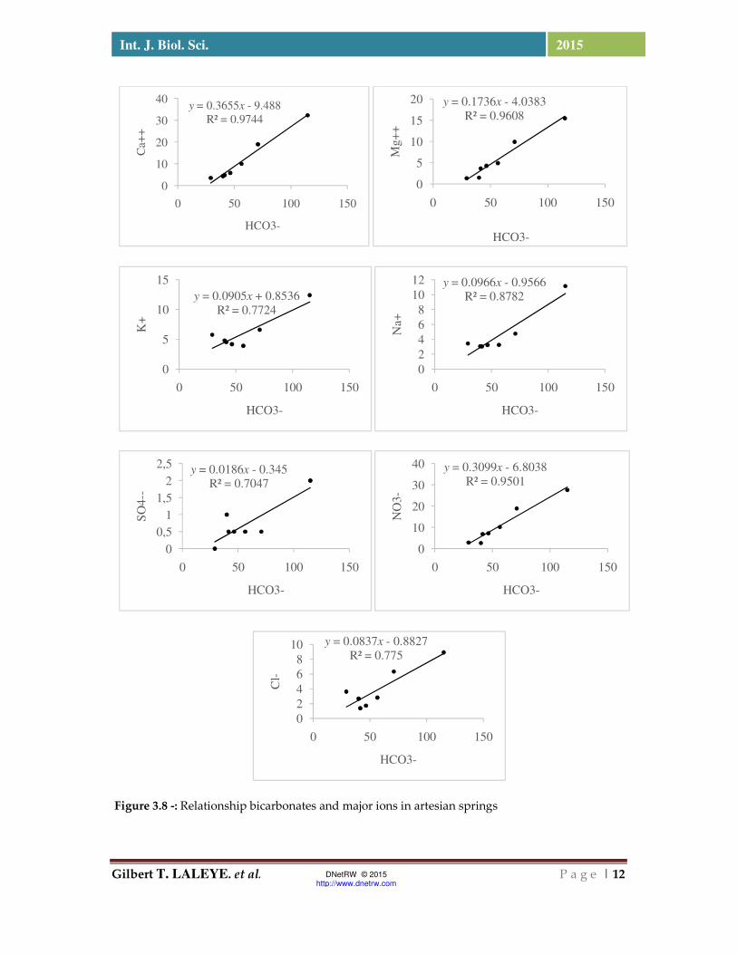
3.6 -: Major ion Relationship bicarbonates Figures 3.7 and 3.8 show the relationships
between the major cation contents
individually and bicarbonates in the water
sources and wells. A linear correlation
between the Mg 2+, Na +, and especially the
Ca 2+ ion with bicarbonates in the waters of
artesian springs. This increasing trend is less
meaning with potassium. If it is accepted
that the Mg 2+ ion mostly comes from
silicate weathering mafic minerals, a
significant portion of Ca2 +, Na +, and K +
has an origin dependent hydrolysis
minerals. This confirms the dominant role in
the chemistry of carbonates. Bicarbonates
are produced following the transfer of CO2
by water infiltration, by hydrolysis reaction
which allows on one hand, the formation of
HCO3- and second, increasing the pH
assuming evolution in a closed environment.
This is the basis of these facts that the use
according hydrogéoloques (Babaye, 2012),
HCO3- or pH to link the contact water-rock,
and the production of ion in water. So the
water remains in contact with the rocks over
the hydrolysis time to perform normally
etpar Therefore, the more water will be
mineralized. The relationship is not linear
with the same ions in the water holes, but it
is significant.

Gilbert T. LALEYE. et al. P a g e | 11
Int. J. Biol. Sci. 2015
DNetRW © 2015 http://www.dnetrw.com
y = 0.0208x2 - 2.5103x + 83.633
R² = 0.7887
0
10
20
30
40
50
60
0 20 40 60 80 100
Ca+
+
HCO3-
y = 0.0016x2 - 0.0785x + 1.2942
R² = 0.5675
0
2
4
6
8
10
0 50 100
Mg+
+
HCO3-
y = -0.0002x2 + 0.0997x - 1.3777
R² = 0.4343
0
2
4
6
8
10
0 50 100
K+
HCO3-
y = 0.496x - 3.7855
R² = 0.9573
0
10
20
30
40
50
0 50 100
Na+
HCO3-
0
0,2
0,4
0,6
0,8
1
0 50 100
SO
4--
HCO3-
y = -0.0007x2 - 0.0262x + 11.787
R² = 0.6745
0
5
10
15
0 50 100
NO
3-
HCO3-
y = 0.0063x2 - 0.42x + 10.279
R² = 0.7655
0
5
10
15
20
25
30
0 20 40 60 80 100
Cl-
HCO3-
Figure 3.7 -: Relationship bicarbonates and major ions in artesian wells
Gilbert T. LALEYE. et al. P a g e | 12
Int. J. Biol. Sci. 2015
DNetRW © 2015 http://www.dnetrw.com
y = 0.3655x - 9.488
R² = 0.9744
0
10
20
30
40
0 50 100 150
Ca+
+
HCO3-
y = 0.1736x - 4.0383R² = 0.9608
0
5
10
15
20
0 50 100 150
Mg+
+
HCO3-
y = 0.0905x + 0.8536R² = 0.7724
0
5
10
15
0 50 100 150
K+
HCO3-
y = 0.0966x - 0.9566R² = 0.8782
0
2
4
6
8
10
12
0 50 100 150N
a+HCO3-
y = 0.0186x - 0.345R² = 0.7047
0
0,5
1
1,5
2
2,5
0 50 100 150
SO
4--
HCO3-
y = 0.3099x - 6.8038R² = 0.9501
0
10
20
30
40
0 50 100 150
NO
3-
HCO3-
y = 0.0837x - 0.8827R² = 0.775
0
2
4
6
8
10
0 50 100 150
Cl-
HCO3-
Figure 3.8 -: Relationship bicarbonates and major ions in artesian springs
Gilbert T. LALEYE. et al. P a g e | 13
Int. J. Biol. Sci. 2015
DNetRW © 2015 http://www.dnetrw.com
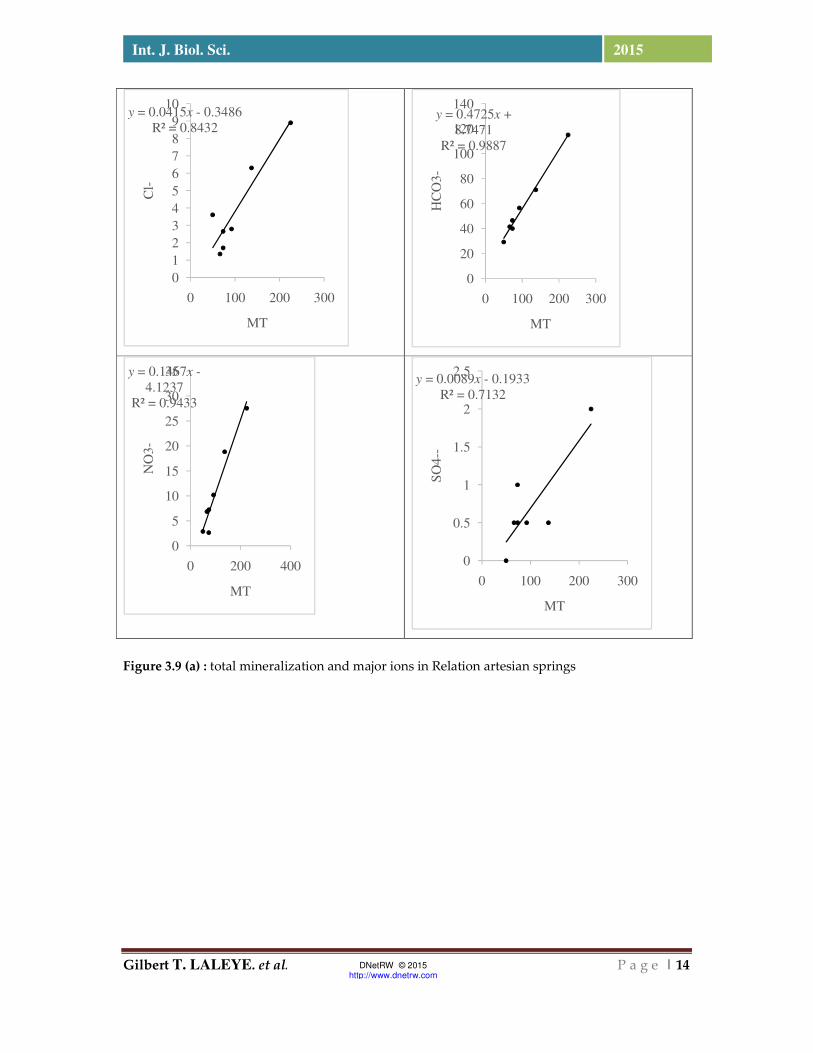
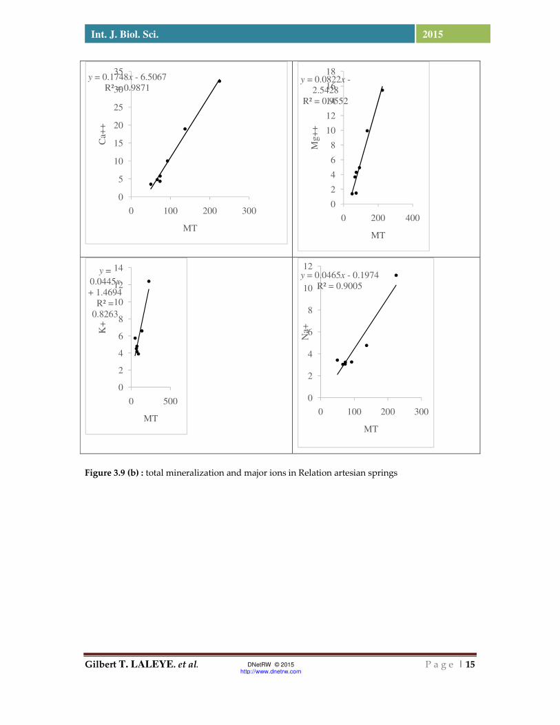
3.7-: total mineralization and major ions in the sources Relationship Figures 3.9 and 3.10 show the proportion of
each ion in the mineralization of waters.
These results highlight the alkano earth Ca2
+ Mg2 + are strongly related to the total
mineralization of water artesian springs (R2
= 0.98 and R2 = 0.95). The Na + also displays
a remarkable connection with the total
mineralization (R2 = 0.90), then comes the K
+ ion with (R2 = 0.82). This order is different
in water wells that show a wide importance
of the Na + ion then comes after the Ca2 +
ion and then ion Mg 2+. At the anions, there
is the preponderance of HCO3- ion over
other anions (NO3-, Cl- SO4-) in water
sources that are abundant accidentally. The
frequency of the Cl ion and its regular layout
reveals its dominance on NO3- ion and its
significant importance in the total
mineralization of water from artesian wells.
Gilbert T. LALEYE. et al. P a g e | 14
Int. J. Biol. Sci. 2015
DNetRW © 2015 http://www.dnetrw.com
Figure 3.9 (a) : total mineralization and major ions in Relation artesian springs
y = 0.0415x - 0.3486
R² = 0.8432
0
1
2
3
4
5
6
7
8
9
10
0 100 200 300
Cl-
MT
y = 0.4725x +
8.7471
R² = 0.9887
0
20
40
60
80
100
120
140
0 100 200 300
HC
O3-
MT
y = 0.1467x -
4.1237
R² = 0.9433
0
5
10
15
20
25
30
35
0 200 400
NO
3-
MT
y = 0.0089x - 0.1933
R² = 0.7132
0
0.5
1
1.5
2
2.5
0 100 200 300
SO
4--
MT
Gilbert T. LALEYE. et al. P a g e | 15
Int. J. Biol. Sci. 2015
DNetRW © 2015 http://www.dnetrw.com
Figure 3.9 (b) : total mineralization and major ions in Relation artesian springs
y = 0.1748x - 6.5067
R² = 0.9871
0
5
10
15
20
25
30
35
0 100 200 300
Ca+
+
MT
y = 0.0822x -
2.5428
R² = 0.9552
0
2
4
6
8
10
12
14
16
18
0 200 400
Mg+
+
MT
y =
0.0445x
+ 1.4694
R² =
0.8263
0
2
4
6
8
10
12
14
0 500
K+
MT
y = 0.0465x - 0.1974
R² = 0.9005
0
2
4
6
8
10
12
0 100 200 300
Na+
MT

Gilbert T. LALEYE. et al. P a g e | 16
Int. J. Biol. Sci. 2015
DNetRW © 2015 http://www.dnetrw.com
Figure 3.10 (a) : total mineralization and major ions in Relation artesian springs
y = 0.0002x2 - 0.0958x
+ 16.67
R² = 0.8169
0
2
4
6
8
10
12
0 200 400 600
NO
3-
MT
y = -0.0005x2 +
0.3406x - 24.003
R² = 0.9553
0
5
10
15
20
25
30
35
0 200 400 600
Cl-
MT
y = -0.0011x2 +
0.6307x + 4.8828
R² = 0.9701
0
20
40
60
80
100
120
0 200 400 600
HC
O3-
MT
0
0.5
1
0 200 400 600
SO
4--
MT
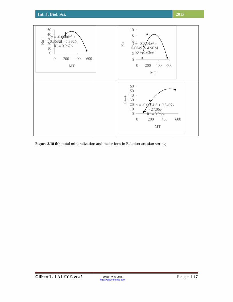
Gilbert T. LALEYE. et al.
Int. J. Biol. Sci.
Figure 3.10 (b) : total mineralization
y = -0.0006x2 +
0.3637x - 7.3926
R² = 0.9676
0
10
20
30
40
50
0 200 400 600
Na+
MT
DNetRW © 2015 http://www.dnetrw.com
total mineralization and major ions in Relation artesian spring
600
y = -0.0001x2 +
0.0849x - 4.9674
R² = 0.6266
0
2
4
6
8
10
0 200 400 600
K+
MT
y = -0.0004x2 + 0.3407x
- 27.063
R² = 0.9660
10
20
30
40
50
60
0 200 400
Ca+
+MT
P a g e | 17
2015
x
600

Gilbert T. LALEYE. et al. P a g e | 18
Int. J. Biol. Sci. 2015
DNetRW © 2015 http://www.dnetrw.com
3.8 - Binary Relations between sodium and chloride
In the event that the sodium and chloride ions
have originated seawater thanks to the
contributions of the rains (the study area is
approximately 150 km from the Atlantic
coast), the ion ratio Cl / Na + (ion ratio in mg /
l on mg / l) should be identical to that of
seawater, therefore close to 1.8. These ions
ratio Cl / Na + are significantly below this
value for all drilling and artesian springs in
the rainy season and were above 1.8 for the
following drilling Hon (1.98), Zoukou (2 , 74)
and Gbata (2.02) in the dry season. At the
artesian springs, always dry season, we got to
Kahodji (1.96) and Massavi (2.54) Table 3.2
Table 3.2: Evolution of chloride contents based on sodium contents.
Rainy
season
Param Hon Zoukou Gbata Samionta Kpokissa
Cl- 23,8 2,2 2,2 2,1 5,7
Na+ 62,32 5,5 42,23 40,34 56,86
cl-/Na 0,38 0,4 0,05 0,05 0,10
Dry
season
Param Hon Zoukou Gbata Samionta Kpokissa
Cl- 21,3 9,23 8,52 8,52 38,69
Na+ 10,74 3,36 4,2 6,77 28,94
cl-/Na 1,98 2,74 2,02 1,25 1,34
Rainy
season
Param Kahodji Ahandatin Tovè Dovè Massavi Wakpa N’gbedè
Cl- 2,6 8,1 2,6 1,7 4,7 0,6 2,28
Na+ 4,51 8,23 4,03 3,07 6,41 4,17 3,75
Cl-/Na 0,57 0,98 0,64 0,55 0,73 0,14 0,61
Dry season
Param Kahodji Ahandatin Tovè Dovè Massavi Wakpa N’gbedè
Cl- 4,6 9,7 2,7 1,7 7,9 2,1 3,3
K+ 2,34 14,08 2,1 3,4 3,1 1,9 2,75
Cl-/Na 1,96 0,68 1,28 0,5 2,54 1,11 1,2
Gilbert T. LALEYE. et al. P a g e | 19
Int. J. Biol. Sci. 2015
DNetRW © 2015 http://www.dnetrw.com
DISCUSSION 4.1-: Water Temperature The results of the ANOVA showed that there
was a significant difference (p <0.01) between
the temperature of the water source and
artesian wells. Artesian wells showed a higher
average temperature (32.95 ± 1.59) and the
artesian springs an average of (28.58 ± 0.45)
according to the Student test Newman-Keuls.
These data, close to atmospheric average
temperature of the study area (32.8 ° C),
indicate a thermal equilibrium between the
aquifer and the atmosphere. Graphs 1a and 1b
show the seasonal variations of temperature
in the waters of artesian wells and springs. In
the drilling and Hon Zoukou, the temperature
of the dry season the water is higher than the
temperature in the rainy season by cons in
drilling Gbata of Samionta and Kpokissa, no
difference was observed between the
temperatures dry season and the rainy season.
Otherwise at the artesian wells, a large
variation of the temperature is observed by
the season in the sources. Indeed sources
Kahodji, Ahandatin, Dove and Wakpa have a
lower temperature in the dry season than
rainy season while the sources of Tove and
Massavi have a high temperature, as in the
dry season than in the rainy season. However,
the temperature at the source of N'gbèdè has
not changed regardless of the season.
Temperatures remain stable throughout year
except the source of Wakpa and drilling Hon.
Temperatures remain stable throughout the
year except the source of Wakpa and drilling
Hon. Changes in the temperature of the water
sources and wells appear to follow seasonal
changes of the average air temperature in the
study area (32.8 ° C). This confirms the
influence of climate on groundwater resources
shallow region. High temperatures are
recorded at the boreholes, and the lowest is
recorded in the sources . This is underlined by
Babaye (2012) , which affirms that the highest
temperature values are encountered in deep
aquifers and lowest values are recorded in the
superficial layers .
4.2 - Electric Conductivity
The stability of the mineralization observed at
most of the works can be conveyed by the
absence of the rainy season in phenomena of
dilution and non increased mineralization in
the dry season. This feature is explained by
the fact that drilling and artesian sources are
located in areas where recharge often reaches
late the tablecloth (confined aquifer) and the
presence of a clay layer that prevents the
vertical infiltration . However, at the artesian
wells of Hon Kpokissa and a respective
difference 184 S / cm and 48 S / cm was
observed between the dry season and the
season. Indeed, the mineralization remains
high compared to the rainy season in the
waters of drilling Hon. As against it is higher
during the dry season than the wet season in
the waters of drilling Kpokissa. The
hydrodynamics of groundwater is a major
determinant of the change in the
mineralization of groundwater. Indeed, in the
rainy season, water flows into underground
reservoirs result in the dilution phenomenon
and decreased mineralization rate (if water
drilling Kpokissa). Alassane (2002), supported
by Totin (2010) explains that the great drought
which lasts from December to April can
promote evaporation phenomena probably
the origin of the strong mineralization of the
waters in this period. The increase in
mineralization loading time (if the drilling
Hon) may be due either to the dissolution of
minerals located in places of geological
formations, or the arrival of sewage into these
areas of Boukari table (1998) and Alassane

Gilbert T. LALEYE. et al. P a g e | 20
Int. J. Biol. Sci. 2015
DNetRW © 2015 http://www.dnetrw.com
(2002). Artesian springs are located in areas
where recharge belatedly reached the table,
because of its great depth or the presence of a
clay layer that prevents the vertical
infiltration; all this results in the absence of
dilution phenomena and increased
mineralization.
. Artesian wells have conductivities ranging
from 40-226 μS.cm-1 and an average of 94.8
μS.cm-1 in the rainy season. Artesian springs
are generally low conductivities ranging from
27 to 157.5 μS.cm-1 with an average of 62.2
μS.cm-1 in the dry season. The decrease in
conductivity is due to the process of mixing
between recent recharge waters and waters of
the aquifer by the phenomenon of diffusivity .
The increase in conductivity observed after
the rainy season is due to the contributions of
more mineralized surface water ( Hassan ,
2010). The stability of the electrical
conductivity in some locations is justified by
the fact that the charging has not yet reached
the web this because of the piezometric
surface which is very deep or because of the
presence of a layer of clay which prevents
vertical infiltration .
Aquifers and aquifer crutacé of limestone Eo-
Paleocene of the common Zogbodomey and
Cretaceous ( Turonian - Coniacien ) of the
Common Zagnanado are predominantly
sandy and sandy clay , or intercalation with
conglomeratic levels ( conglomerate base) and
oolitic . These siliceous dominant formations
are few minerals . The geological nature of the
soil formations and ZNS are factors that
influence changes in the electrical
conductivity ( Hassan , 2010). According
Babaye , (2012) in a recent study on Dargol
Basin in Niger , the pH values and those of
the electrical conductivity is high in the dry
season ( low water ) and fall after the rainy
season ( high water ) . However, some
contaminated wells observe the opposite
effect due to the contribution of NO3 ion by
seepage causing increased water
mineralization . As for Adiaffi (2009), in a
study on the contribution of isotope
geochemistry, water chemistry and Remote
Sensing to the knowledge of aquifers in the
area of contact " base - sedimentary basin "
South eastern coast ivory , he stated that the
layers of the sedimentary basin ( including
that of the Continental Terminal) are weakly
mineralized and the trend shows that
groundwater appear to change over time .
They become more and more acidic and less
mineralized. This statement is the result of
collection of data on temperature, pH ,
electrical conductivity for three years. Our
observations on these three parameters are
made only for one or two seasons. It would be
difficult to talk about their evolution.
4.3 - pH of the water PH artesian wells is in the range of 4.4 to 6.5
with a mean of 5.4 and a standard deviation of
0.6 and in the range of 5.6 and 6.5 for the
sources artesian with a mean of 6.0 and a
standard deviation of 0.2. The lowest pH were
measured in water from artesian wells. The
highest pH values are found in the waters of
artesian springs. And drilling water has a
relatively acidic pH with an average of 5.4. As
against the sources whose average pH is close
to neutral. This tendency to neutrality in the
waters of artesian springs is due to the
consumption of CO2 following the hydrolysis
of silicate causing increased alkalinity (HCO3)
water (Schoeller, 1962; Faillat and Drugs, 1993
cited by Babaye, 2012). In contrast the results
of drilling of water acidity are consistent with
those of (Boukari, 1998; and Alassane 2004;
quoted by Totin, 2010) for which the silicate
nature of the tanks or the dissolution of the
acid carbonate from atmospheric CO2 can
explain this acidic groundwater. The lowest
Gilbert T. LALEYE. et al. P a g e | 21
Int. J. Biol. Sci. 2015
DNetRW © 2015 http://www.dnetrw.com
pH were measured in the Paleocene limestone
aquifer (IIb unit) ( Lama depression ) who is
confined aquifer under the argillites and
marls of Upper Paleocene and Lower and
Middle Eocene . Its thickness varies only a
few meters to thirty meters maximum. The
highest pH values are found in the
groundwater in the aquifer of the Cretaceous (
Turonian - Coniacien or Unit I) north of the
depression of the Lama, where sandy
Coniacien flush and captive under the
Maastrichtian marls and argillites and the
Eocene to the south, where the sinks quickly
Coniacien. These different observations show
that the waters of crutacé and Eocene in the
town of Zogbodomey are predominantly
acidic tendency in the town of Zogbodomey ,
while the waters of the sheet of the Cretaceous
aquifer ( Turonian - Coniacien ) of the
common Zagnanado slightly basic or neutral .
These various results are consistent with the
geological nature of aquifers in dominant
acids whose dominant facies is represented by
sand and fine quartz sandstone and greenish
gray clays , kaolin puff , and aquifers
dominance in neutral or slightly basic with
the dominant facies is represented by the
deposits formed quartz sand , sandstone or
siliceous ferruginous cement with kaolin clay
and quartz gravels angular to rounded ,
reflecting a similar origin ( Hassan , 2010).
4.4 -: Chemical Facies water Regarding chemical facies Ahandatin artesian
water sources, N'gbède, Masavi, Dove, Tove,
Wakpa type calcium bicarbonate, magnesium
in the rainy season does not experience
variation in dry season. The water from the
source Kahodji calcium chloride-facies in the
rainy season passes facies sodium bicarbonate
in the dry season. At the level of drilling
Samionta, Gbata, Zoukou, Kpokissa, the water
initially facies bicarbonate sodium and
potassium in the rainy season has become
chlorinated lime for drilling Samionta of
Gbata and Zoukou. However water drilling
Kpokissa initially facies sodium and
potassium bicarbonate water well drilling
Hon calcium bicarbonate facies in the rainy
season pass to chlorinated sodic facies in the
dry season.
Of the rainy season to the dry season, is
observed dynamics of geochemical facies in
water (artesian wells) while it remains
unchanged for almost all water sources except
artesian water source Kahodji. These
variations are attributed according Mudry
(1987) cited by Totin (2010) to the estate of
hydrological events (which alter the quantity
and quality of water in the aquifer), and you
may have other processes Internal to the
system (such as the physico-chemical
interactions between the phases). Each water
is unique and its nature depends on the
chemical composition of the rocks through
which it passes and mixtures may occur.
There is therefore no one but the qualities of
the water. Groundwater is more or less
mineralized depending on the nature of the
rocks; the water contact time with the rock
minerals, therefore the water percolation rate;
time for renewal of the water table by seepage
water. Of the rainy season that sèches'observe
dynamic geochemical facies in water (artesian
wells) while it remains unchanged for almost
all water sources except artesian water source
Kahodji. These variations are attributed
according Mudry (1987) cited by Totin (2010)
to the estate of hydrological events (which
alter the quantity and quality of water in the
aquifer), and you may have other processes
internal to the system (such as the physico-
chemical interactions between the phases). In
general, calcium bicarbonate facies dominates
all others in filing the results of this study, 58
%. This trend is confirmed by previous work
in Senegal ( Diouf, 1999) , Côte d' Ivoire (

Gilbert T. LALEYE. et al. P a g e | 22
Int. J. Biol. Sci. 2015
DNetRW © 2015 http://www.dnetrw.com
Faillat 1986; Biemi 1992; Adiaffi , 2008 Oga et
al ., 2009) in Burkina Faso ( Yameogo 2008 ) ,
Benin KAMAGATE , 2006). The waters of this
group show a dominance of alkano earth ions
on alkaline ( Babaye , 2012). The bicarbonées
sodic waters cover five books. They are
characterized by the dominance of the alkano
alkaline earth metal and also by the low value
of electrical conductivity ( Babaye , 2012).
Drilling artesian Samionta , Kpokissa , Gbata ,
Hlanhonou and source Kahodji respectively
40.34 mg / L, 56.86 mg / L, 42.23 mg / ; 5.50 mg
/ l; 10.90 mg / l of sodium contents against 1.44
mg / l, 28 mg / L , 1.96 mg / l 1.04 mg / l 4.4 mg
/ l calcium. The water of this group have
sodium contents of two to twenty eight times
greater than those of calcium. The trend
achieved in the work of Babaye is of the order
of (Na + > 1.5 Ca2 +).
4.5: Major ion Relationship bicarbonates
A linear correlation between the Mg2+, Na +,
and especially the Ca2+ ion with bicarbonates
in the waters of artesian springs. This
increasing trend is less meaning with
potassium. If it is accepted that the Mg2+ ion
mostly comes from the weathering of silicate
ferromagnesian minerals, a significant portion
of Ca2+, Na+, and K+ has an origin dependent
hydrolysis minerals. This confirms the
dominant role in the chemistry of carbonates.
Bicarbonates are produced following the
transfer of CO2 by water infiltration, by
hydrolysis reaction which allows on one
hand, the formation of HCO3- and second,
increasing the pH assuming evolution in a
closed environment. This is the basis of these
facts that the use according hydrogéoloques
(Babaye, 2012), HCO3- or pH to link the
contact water-rock, and the production of ion
in water. Thus, the water remains in contact
with the more hydrolysis rocks time to
perform and therefore normally, the more
water will be mineralized. The relationship is
not linear with the same ions in the water
holes, but it is significant.
4.6: Relation total mineralization and major ions in the sources and boreholes Total mineralization in the relationship and
major ions in the sources and boreholes in the
region, the results highlight that alkano earth
Ca2+ Mg2+ are strongly related to the total
mineralization of water artesian springs (R2 =
0.98 and R2 = 0.95). The Na + also displays a
remarkable connection with the total
mineralization (R2 = 0.90), then comes the K +
ion with (R2 = 0.82). This order is different in
water wells that show a wide importance of
the Na + ion then comes after the Ca2+ ion and
then ion Mg2+ . At the anions, there is the
preponderance of HCO3- ion over other
anions (NO3-, Cl-, SO42-) in water sources that
are abundant accidentally. The frequency of
the Cl- ion and its regular layout reveals its
dominance on NO3- ion and its significant
importance in the total mineralization of
water from artesian wells. The positive trend
between HCO3- ion and total mineralization
confirms the main source of this element
dissolution silicate minerals. These analyzes
clearly within the role of each ion in the
mineralization of the water. It is found that,
just as the majority ions (Ca2+, Mg2+, Na+ and
HCO3-), accidental ions such as (NO3-, Cl-,
SO42-), also have an influence on the
mineralization of the water.
4.7 - Binary Relations between sodium and chloride
In the event that the sodium and chloride ions
have originated seawater thanks to the
contributions of the rains (the study area is
approximately 150 km from the Atlantic
coast), the ion ratio Cl- / Na+ ( ion ratio in mg /
l on mg / l) should be identical to that of
seawater, therefore close to 1.8. This feature
Gilbert T. LALEYE. et al. P a g e | 23
Int. J. Biol. Sci. 2015
DNetRW © 2015 http://www.dnetrw.com
when it is in the dry season observed ion
reports Cl- / Na + above 1.8 is explained by
the fact that drilling and artesian sources are
located in areas wherein the refill often
reached late the web (confined aquifer) and
the presence of a clay layer that prevents
vertical infiltration. All other ion report data
Cl- / Na+ Who are significantly below 1.8
rather reveal behaviors related to the effect of
anthropogenic pollution, and to a lesser
extent, the sodium intake by interaction
water- rock.
The frequency of the ion NO3- reveals its
dominance on Cl-, SO42-, and its significant
importance in the mineralization of water
from artesian springs.
Water characteristics of sources and artesian wells In both seasons, the mineralization of water
from artesian springs includes electrical
conductivity , nitrates , potassium , chloride ,
sodium, calcium and magnesium sulphates .
Dassi (2011 ) states that the primary source of
mineralization is the dissolution , while the
second is due to anthropogenic processes.
Major ions follow the following distribution:
Ca2+ > Na+ > K+ > Mg2+ for cations and HCO3- >
NO3- > SO42- > Cl- for anions in the waters of
the Cretaceous formations in the argillites and
marls Maastrichtian ( artesian springs ) .
Previous work by ( the Vaissière , 2006; Diaw,
2008; Yaméogo , 2008; quoted by Babaye ,
2012) showed that Ca2+ , Mg2+ are generally
provided by the hydrolysis , so deep origin,
while the NO3- ions are generally the
superficial sources. Major ions follow the
following distribution: Na+ > Ca2+ > K+ > Mg2+
cations for and HCO3- > Cl- > NO3- > SO42- for
anions in the waters of artesian wells. The
geochemistry of water drilling has
highlighted the sensitivity of the aquifer to
surface pressures. Drilling water are mainly
characterized by a deficit in Ca2 + bound to
relatively high contents of Na + . A cation
exchange process seems to occur in aquifers
Eocene leading to preferential adsorption of
divalent cation , leading to a concentration in
the solution of the Na+ ion, leaving a deficit of
Ca2+ and Na+ enrichment ( Hassan , 2010). The
presence of NO3- ions in this group expresses
the influence of anthropiques Activities in the
acquisition of the mineralization of water
artesian springs. Nitrates are very good
indicators of diffuse pollution. They have as
main natural degradation of organic matter ,
which brings their maximum concentration in
groundwater about 12 mg / L ( Desbordes ,
2001). The relationship between nitrate levels
and concentrations of sulfates and chlorides
elements can then be used to distinguish the
origin of these minerals. Whether in the water
sources that water artesian wells nitrates are
correlated with chlorides. The relationship
between the two elements , confirming that
the chlorides come mainly from human
activities. The agriculture and livestock
provide various chemical elements (Na +,
NO3- , Cl-, SO42-) which are driven up to the
web by seepage ( Babaye , 2012). The
beginning of nitrated pollution in the study
area , prompts us to seek the origin of this ion
. CPA conducted on groundwater showed
that NO3 ion is from surface. Also, the
relationship with nitrates chlorides showed
the common origin. If we accept the
hypothesis that nitrates are from surface, the
web thus have its maximum at the end
content rainy seasons ( Babaye , 2012). To test
this hypothesis, it was highlighted the change
in nitrate levels between the rainy and dry
season. From our observations , it appears
that almost all sources reached the highest
value of nitrate during the rainy season
Massavi (21.8 mg / l against 15.9 mg / l) ,
Wakpa ( 7.1 mg / l against 6 5 mg / l) ,
Ahandatin (31.4 mg / l against 23.7 mg / l) ,
N'bèdè (10.5 mg / l against 8.8 mg / l) Dove
Gilbert T. LALEYE. et al. P a g e | 24
Int. J. Biol. Sci. 2015
DNetRW © 2015 http://www.dnetrw.com
(7.4 mg / l against 6.1 mg / l) ( Hamza et al .,
2007; . et al Saadi 999). Nitrate (NO3-) and
nitrite ( NO2- ) ions are naturally present in the
environment. They are the result of
nitrification of the ammonium ion (NH4 + ) in
the water and soil, which is oxidized to
nitrites by bacteria of the genus Nitrosomonas
, and then into nitrates by bacteria of the
genus Nitrobacter (INSP Quebec , 2003). In
unpolluted waters, the nitrate level is very
variable (from 1 to 12 mg / L) , according to
the season and the origin of water ( Desbordes
, 2001). The presence of nitrates above the
levels of 12mg / l in drinking water is
primarily due to human activities (INSP
Québec , 2003). The nitrate problem is the
consequence of the development of live
livestock one hand, and the massive use of
fertilizers for cash crops like cotton on the
other . There are in the town of Zogbodomey ,
according to statistics from CeCPA in 2013, 70
427 poultry heads 12,000 heads of small
ruminants and 2,991 head of cattle . On the
other hand, to Zagnanado , there are 63,400
poultry heads, heads 32415 sheep and goats
and pigs 31700 heads. There are virtually no
adequate pastoral infrastructure in both
municipalities. These animals left straying
pollute the environment through their
droppings. Non mastery of farming
techniques, lack of access to veterinary care
we are unfortunately witnessing a strong
small ruminant mortality rates . Often dead
animals are thrown on rubbish heaps.
Nitrogen is an essential component of all
living beings as part of the composition of
proteins and nucleic acids. Nitrates can come
from organic waste ( human and animal) . In
rural areas , pollution is mainly related to cash
crop production that requires the application
of pesticides and fertilizers . Often these
products are used in excess, this has a
negative influence on the ground. The
concentration of groundwater in the study
area is at given locations close to 50 mg / l,
acceptable limit for human consumption by
the WHO. When considering the Decree 2001-
094 of 20 February 2001 for the protection of
water intended for consumption, nitrate
concentration of groundwater is above 45 mg
/ l, Dohounmè , Assiangbomé in the town of
Zagnanado and Avlamé kotokpa 2 in the
town of Zogbodomey. The results of our
study also show that the population buys
water in artesian wells studied consumes
water of between 1.9 and 15.2 mg / L of nitrate
and one that buys in the sources studied
consumes water having between 2.1 and 31.4
mg / L. Human activities have an impact on
the quality of water from artesian springs and
boreholes common Zagnanado and
Zogbodomey . The quality of groundwater is
affected by high nitrate levels in the years to
come, tribute to the strong agricultural yields.
Unlike in Europe ( Martelas et al , 19997 ; .
Hallet , 1998; Marjolet et al ., 2000; widory et
al ., 2004; Durand, 2005; Orban, 2009) and
North Africa ( Saadi et al, 1999 ; Hamza et al,
2007 ) where diffuse pollution related to
agricultural activities is dominant, the Sub-
Saharan Africa is more subject to occasional
pollution due to sewage effluent and / or
latrine ( Nkotagu , 1996; Girard, 1993; et al
Tandia . 1999) and livestock ( Diouf , 1999).
Conclusion The objective of this study was to compare the
water sources and artesian wells with the
addition of water chemistry. The
hydrochemical standpoint, water artesian
springs have a chemical signature similar to
that of water artesian wells.
The pH of the artesian water sources varies
from 5.6 to 6.5 while that of water artesian
wells is between 4.4 to 6.5. The electrical
conductivity of the water sources varies from
27 to 157.5 μS.cm-1 and the borehole between
40-226 μS.cm-1. Calcium (Ca2+) is the principal
Gilbert T. LALEYE. et al. P a g e | 25
Int. J. Biol. Sci. 2015
DNetRW © 2015 http://www.dnetrw.com
cation and anion is the main carbonate ion
(HCO3-) for water artesian springs. While
sodium (Na +) is the major cation and anion is
the main carbonate ion (HCO3-) for water
from artesian wells. Of the rainy season to the
dry, is observed dynamics of geochemical
facies in water (artesian wells) while it
remains unchanged for almost all water
sources except artesian water source Kahodji.
Comparison of ion ratios Cl-/ Na+ are more
students in the waters of artesian wells as
water artesian springs as the area where
drilling was located closer to the coast than
the region where the sources are. This ion
relative Cl-/ Na+ is just above 1.8 in the dry
season for some sources and wells. It is found
that, just as the majority ions (Ca2+, Mg2+, Na+
and HCO3- accidental ions such as (NO3-, Cl-,
SO42-), also have an influence on the
mineralization of the water.
REFERENCES
[1] ALASSANE A., (2000) - Contribution
à l'étude hydrochimique de l'aquifère
du Continental terminal du plateau de
Sakété d~ns le bassin sédimentaire
côtier du Bénin. Mémoire de.DEA.
[2] Univ. C. A. Diop de Dakar. 88p. +
annexes.
[3] ALASSANE A., 2004. Etude
hydrogéologique du continental
terminal et des formations de la plaine
littorale dans la région de Porto-Novo
(sud du Benin) : identification des
aquifères et vulnérabilité de la nappe
superficielle. Thèse de Doctorat de
Troisième Cycle. Université Cheikh
Anta Diop de Dakar. Faculté des
Sciences Et Techniques Département
de Géologie, 145 p.
[4] Babaye. M. S. A., 2012. Evaluation des
ressources en eau souterraines dans le
bassin de Dargol (Liptako-
Niger).Thèses Doct. ès Sci., Univ. De
Liège. Univ Abdou Moumouni.
Faculté de Sciences et Techniques.
Département de Géologie Niger, 244
p.
[5] Biémi J. 1992. Contribution à l’étude
géologique, hydrogéologique et par
télédétection des bassins versants
subsaheliens du socle précambrien de
l’Afrique de l’Ouest :
Hydrostructurale, hydrodynamique,
hydrochimie et isotopie des aquifères
discontinus de sillons et aires
granitiques de la haute Marahoué
(Côte d’Ivoire). Thèse de doctorat
d’Etat de l’Université d’Abidjan, Côte
d’Ivoire, p. 493.
[6] Boukari M., 2002. Réactualisation des
connaissances hydrogéologiques
relatives au bassin sédimentaire côtier
du Bénin. Direction de l’Hydraulique,
Cotonou, 134 p. + annexes.
[7] Canceill M et Landreau A, 1978.
Analyse statistique
multidimensionnelle : Proposition
méthodologique pour l’analyse de
données concernant la chimie des
eaux souterraines. Rapport BRGM, 78
SGN 001 HYD. 36 p
[8] Desbordes A., 2001. Qualité,
dépollution et traitement des eaux de
nappes.Mém. D.E.S.S. « Qualité et
Gestion de l'Eau », Fac. Sci., Amiens,
65 p. + annexes.
[9] Faillat JP, Drogue C. 1993.
Différenciation hydrochimique de
nappes superposées d’altérites et de
fissures en socle granitique. J. Sci. Hydrol., 38(3): 215- 229.
[10] Institut national de santé publique du
Québec, 2003. Groupe scientifique sur
l’eau. Fiche Nitrates/Nitrites, 12 p
Gilbert T. LALEYE. et al. P a g e | 26
Int. J. Biol. Sci. 2015
DNetRW © 2015 http://www.dnetrw.com
[11] Ministère de l’Environnement, de
l’Habitat et de l’Urbanisme., 2012.
Projet d’Appui à la Gestion des Forêts
Communales (PAGEFCOM)
Commune de Zagnanado, Tecsult
International Limitée ,49 p.
[12] Ministère de l’Environnement, de
l’Habitat et de l’Urbanisme., 2012.
Projet d’Appui à la Gestion des Forêts
Communales (PAGEFCOM)
Commune de Zogbodomey, Tecsult
International Limitée ,49 p.
[13] Mudry J., 1987. Apports du traçage
physico-chimique naturel à la
connaissance hydrocinématique des
aquifères carbonatés. Thèse de
Doctorat ès sciences naturelles,
Université Besançon, Paris.
[14] Scoëller H, 1962. Les eaux
souterraines : Hydrologie dynamique
et chimie, Recherche, Exploitation des
aquifères fissurés au Mali. Projet.
AIEA/RAF/8/012, pp 77-93
[15] Totin H. S., 2010. Sensibilité des eaux
souterraines du bassin sédimentaire
côtier du Bénin a l’évolution du climat
et aux modes d’exploitation :
stratégies de gestion durable. Thèse de
Doctorat de l’Université d’Abomey-
Calavi. Bénin, 283 p.
[16] Wethé J, Radoux M et Tanawa E, 2003.
Assainissement des eaux usées et
risques socio sanitaires et
environnementaux en zone d'habitats
planifiés de Yaoundé (Cameroun).
Vertigo. Revue des sciences de
l’environnement, 4 (1) : 1-12.