Archaeological investigations at Sveigakot 2002
83
Archaeological investigations at Sveigakot 2002 Orri Vésteinsson ed. With contributions by Thomas McGovern, Karen Milek, and Przemyslaw Urbanczyk Fornleifastofnun Íslands FS206-00213 Reykjavík 2003
Transcript of Archaeological investigations at Sveigakot 2002
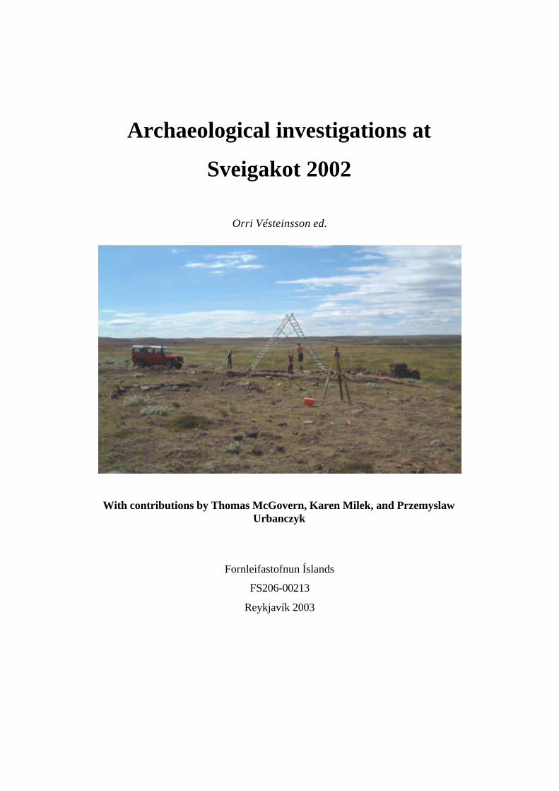
Archaeological investigations at
Sveigakot 2002
Orri Vésteinsson ed.
With contributions by Thomas McGovern, Karen Milek, and Przemyslaw Urbanczyk
Fornleifastofnun Íslands
FS206-00213
Reykjavík 2003
2
© Fornleifastofnun Íslands 2003.
3
Contents
Orri Vésteinsson:
Introduction 4
Karen Milek
Area S. Interim report 7
Przemyslaw Urbanczyk
Area T - excavation report for 2002 34
Thomas H. McGovern
Herding Strategies at Sveigakot: an Interim Report 48
Orri Vésteinsson
Samantekt 70
Appendices 74
4
Orri Vésteinsson
Introduction
In 2002 work continued apace at the Sveigakot site. As in previous years the excavation of
the long house on the northern side of the site was lead by Karen Milek and the excavation of
sunken buildings on the southern side of the site by Przemyslaw Urbanczyk. On both ends of
the site lowest levels of occupation were revealed, and both teams were able to clarify the
sequence of events at their respective parts of the site. Excavations of Area T, the sunken
buildings on the southern end of the site, are as good as finished, whereas the base layers in
Area S, the dwelling on the northern end of the site, remain to be removed.
Important revisions have been made as to the development of the dwelling complex in
Area S. It is now believed (Milek below) that this was originally a fairly typical Viking age
long house (albeit on the small side), a single structure with bow-shaped long walls and a
central hearth. After a period of abandonment – sometime in the 11th century – a new
dwelling was built on the ruins. This was a much narrower building than its predecessor but it
also had extensions to the north and east. This suggests that the Sveigakot story is not one of
simple decline but rather a much more complex development, involving at least two phases of
significant investment followed by decline, first in the 11 th century and again in the late 12th
or early 13th century. The extensions to structure 1 are particularly interesting in the context
of the debate on the development of the Icelandic farm-house, and in particular the transition
from Viking age building customs to high and late medieval house forms. The byre tucked on
to one end of the dwelling only has one parallel in Iceland, the site of Þórarinsstaðir in
Hrunamannaafréttur in S-Iceland, also a marginal highland site dated to the 11 th century. The
smaller extension to the north has many more parallels (Grelutóttir, Granastaðir, Ísleifsstaðir,
Hvítárholt VIII and IX are the closest – normally believed to be from the 10th century rather
than the 11th and 12th as Sveigakot 5). The original use of the extension as a pantry is in
agreement with the interpretation of similar extensions at other sites, but the later use of the
extension as a kitchen has not been observed elsewhere. This development at Sveigakot may
herald the removal of food preparation and heat source from the sleeping area to separate
rooms evident in late medieval and early modern Icelandic farm houses. It may also serve as
a reminder that the variations the use of space in the Icelandic farm house may always have
5
been considerable and may have more to do with factors such as location or social status
rather than chronological developments.
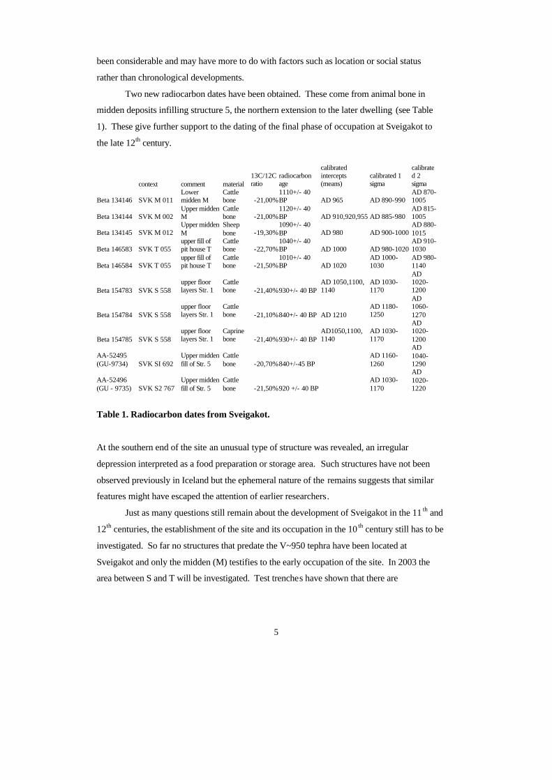
Two new radiocarbon dates have been obtained. These come from animal bone in
midden deposits infilling structure 5, the northern extension to the later dwelling (see Table
1). These give further support to the dating of the final phase of occupation at Sveigakot to
the late 12th century.
Table 1. Radiocarbon dates from Sveigakot.
At the southern end of the site an unusual type of structure was revealed, an irregular
depression interpreted as a food preparation or storage area. Such structures have not been
observed previously in Iceland but the ephemeral nature of the remains suggests that similar
features might have escaped the attention of earlier researchers.
Just as many questions still remain about the development of Sveigakot in the 11 th and
12th centuries, the establishment of the site and its occupation in the 10 th century still has to be
investigated. So far no structures that predate the V~950 tephra have been located at
Sveigakot and only the midden (M) testifies to the early occupation of the site. In 2003 the
area between S and T will be investigated. Test trenches have shown that there are
context comment material 13C/12C ratio
radiocarbon age
calibrated intercepts (means)
calibrated 1 sigma
calibrated 2 sigma
Beta 134146 SVK M 011 Lower midden M
Cattle bone -21,00%
1110+/- 40 BP AD 965 AD 890-990
AD 870-1005
Beta 134144 SVK M 002 Upper midden M
Cattle bone -21,00%
1120+/- 40 BP AD 910,920,955 AD 885-980
AD 815-1005
Beta 134145 SVK M 012 Upper midden M
Sheep bone -19,30%
1090+/- 40 BP AD 980 AD 900-1000
AD 880-1015
Beta 146583 SVK T 055 upper fill of pit house T
Cattle bone -22,70%
1040+/- 40 BP AD 1000 AD 980-1020
AD 910-1030
Beta 146584 SVK T 055 upper fill of pit house T
Cattle bone -21,50%
1010+/- 40 BP AD 1020
AD 1000-1030
AD 980-1140
Beta 154783 SVK S 558 upper floor layers Str. 1
Cattle bone -21,40%930+/- 40 BP
AD 1050,1100, 1140
AD 1030-1170
AD 1020-1200
Beta 154784 SVK S 558 upper floor layers Str. 1
Cattle bone -21,10%840+/- 40 BP AD 1210
AD 1180-1250
AD 1060-1270
Beta 154785 SVK S 558 upper floor layers Str. 1
Caprine bone -21,40%930+/- 40 BP
AD1050,1100, 1140
AD 1030-1170
AD 1020-1200
AA-52495 (GU-9734) SVK SI 692
Upper midden fill of Str. 5
Cattle bone -20,70%840+/-45 BP
AD 1160-1260
AD 1040-1290
AA-52496 (GU - 9735) SVK S2 767
Upper midden fill of Str. 5
Cattle bone -21,50%920 +/- 40 BP
AD 1030-1170
AD 1020-1220

6
occupational deposits in this area and it is hoped that these will shed further light on the
origins and development of Sveigakot.
The excavations were carried out between July 15 th and August 16th with the
participation of Guðrún Alda Gísladóttir, Karen Milek, Magda Natuniewicz-Sekuta, Jeppe
Skovby, Mette O. Svindby, Przemyslaw Urbanczyck, and.Robert Zukowski. As before the
project is supported by grants from the Icelandic Research Council (Rannís), NSF and The National
Geographic society.
7
Karen Milek:
Area S Interim Report
Introduction
In 2002, excavations in Area S saw the completion of work on Structures 1, 3 and 5, the late
11th to 12th century building complex that had been uncovered during the 2000 and 2001 field
seasons. Two earlier buildings, dating from the late 10 th to early 11th centuries, were also
exposed, one of them in full (Structure 4). The 2002 field season clarified the relationships
between these buildings, and answered many outstanding questions about their size, layout,
and function, and how they had changed over time. As a result, the tent ative phasing of the
buildings and their internal features, as outlined in the 2001 interim report (Milek 2002), has
been significantly revised. The picture of Sveigakot in its last phase of occupation now looks
more complex than it did at the end of the 2001 field season. Rather than a simple scenario of
economic decline, in which the number and size of dwellings steadily decreased between the
10th and 12th centuries, it would now appear that the household at Sveigakot was changing and
flexible, and that rooms were added, abandoned, and altered as necessary.
Methodology
Since some of the midden deposits that infilled Structure 5 extended beyond the northern limit of the
2001 excavation area, Area S was slightly enlarged in 2002 in order to ensure that Structure 5 was
fully exposed. The 6 x 2 m extension gave Area S a total area of 264 m2.
As in previous years, the excavation involved the removal of all soil and sediment by hand,
and the use of single context recording. The strategy for recovering artefacts and environmental
samples was designed to be time effective, and to target those contexts with the greatest potential to
provide important information. Midden deposits and features such as post holes and hearths were
sampled for flotation/wet sieving (up to 40 L, in 20 L buckets), and the remainder dry sieved on site
with 4 mm mesh. From floor deposits, intact block samples were taken for micromorphological
analysis, small, clean samples for geochemical analysis were taken on a 50 cm2 grid, and 100% of the
remaining floor sediment was recovered for flotation/wet sieving on the same 50 cm2 grid. All
artefacts found during the excavation of suspected floor deposits were given three -dimensional co-
8
ordinates. Contexts of potentially diverse origins, such as aeolian accumulations and turf collapse,
were not sieved, but bone, charcoal, wood and artefacts were hand collected. The wood found in Area
S was generally very degraded, but it was collected carefully and double-bagged in order to prevent
moisture loss and further decay.
All of the contexts excavated in Area in 2002 are summarised in Table 1, and have been
incorporated into the cumulative Harris Matrix for Area S (available in the FSI archive). This interim
report presents the results of the 2002 excavation in a sequence of phases from the most recent to the
earliest, following the numbering scheme outlined in the 2001 interim report. These phases can be
applied only to Area S. Where the results of the 2002 field season have significantly changed the
phasing or interpretation of contexts discussed in the 2001 interim report, these changes are also
discussed.
Excavation Results
Phase VII: Natural aeolian accumulation from the late 12 th century to the present
Most of the windblown sand and silt deposits that had covered Area S after its abandonment were
excavated in 2000 and 2001, and the 2002 field season added little new information about this phase.
Deflation by wind has been so drastic in the northern part of Area S that the sandy surface deposits
(context 549) that were cleared from the new excavation area rested directly on top of yellowish
brown, silty subsoil containing the black and dark grey tephra horizons of the Landnám tephra
sequence. In other words, all historic soils and archaeological deposits had been eroded from this
area.
In the subsoil just below the surface in the new excavation area north of Structure 5 there were
many small rounded depressions, now filled with coarse sand and aeolian silt, which appear to have
once contained stones. Although puzzling at first, it is likely that the stones had been removed by 19 th
and early 20th century Grænavatn farmers, who are reported to have collected stones from the boulder
field at Sveigakot and piled them in small cairns in order to have them readily available as dam-
repairing materials in the spring (Orri Vésteinsson 2001: 45).
Phase VI: Site abandonment and structural collapse in the late 12 th century
The deposits associated with the abandonment and collapse of Structures 1 and 2 w ere discussed in the
2001 interim report (Milek 2002: 11-12). Since the 2002 field season clarified the relationships
between all of the structures in the building complex, with the result that Structures 3 and 5 are now
9
considered to be contemporary with Structure 1, the abandonment and collapse of Structures 3 and 5
are now attributed to Phase VI as well.
Unfortunately, the severity of the wind erosion around Structure 5, which is at the top of the
ridge straddled by the Area S building complex, has meant the loss of all soils above the Landnám
tephra sequence, as well as the loss of all evidence for turf walls and the debris associated with their
collapse. The only surviving turf deposits that may be associated with the collapse of Structure 5,
contexts 739 and 741, abutted the north side of the wall 607, which served as the north long wall for
Structures 1 and 4. These contexts were excavated in 2001.
On the north, east, and south sides of Structure 3, where the wind had also eroded all soils
above the Landnám tephra sequence, little survives of the walls or turf wall collapse associated with
this building. The best preservation of archaeological deposits is within the structure, which was
slightly sunken. Here, a deposit of turf collapse containing dark grey tephra lenses, and thought to be
associated with the collapse of the western wall of Structure 3 (which was also the eastern wall of
Structure 1) was excavated in 2000 (context 590) and 2001 (context 728).
The most distinctive turf collapse layer associated with Structure 3 was below context
590/728. This was a firm, plastic, highly organic (peaty) turf, which did not contain any tephra layers,
but was red in lenses where iron oxides had accumulated and cream-coloured in lenses where iron had
been leached (context 625/682). This very distinctive turf must have been cut from a wet, boggy area.
It capped the stone pavement in the centre of the building (624), and is interpreted as roof collapse.
This context is now believed to have been contemporary with identical turf layers that capped the
floors of Structures 1 and 2 (contexts 556 and 577), which have also been attributed to roof collapse.
Although it could have been possible for peaty turf to be selected as roofing material at different
periods in the site’s history, it now seems more likely that the roofs of Structures 1, 2, and 3 were
constructed at the same time with the same building material.
Phase V: Occupation of Structures 1, 2, 3 and 5 in the late 11 th and 12th centuries
Structure 1
Structure 1 has been described in detail in earlier interim reports. It was thought that the building had
been fully excavated in 2001, but the excavation in 2002 clarified the phasing of hearth 796, and
showed that it belonged to Structure 1 as well. This rectangular hearth, which was situated
immediately below hearth 669 was originally thought to be associated with the earlier house, Structure
4. However, the excavation of hearth 796 showed that the cut for this feature truncated earlier phases
of occupation deposits and turf collapse. Hearth 796 therefore belonged to Structure 1, and was
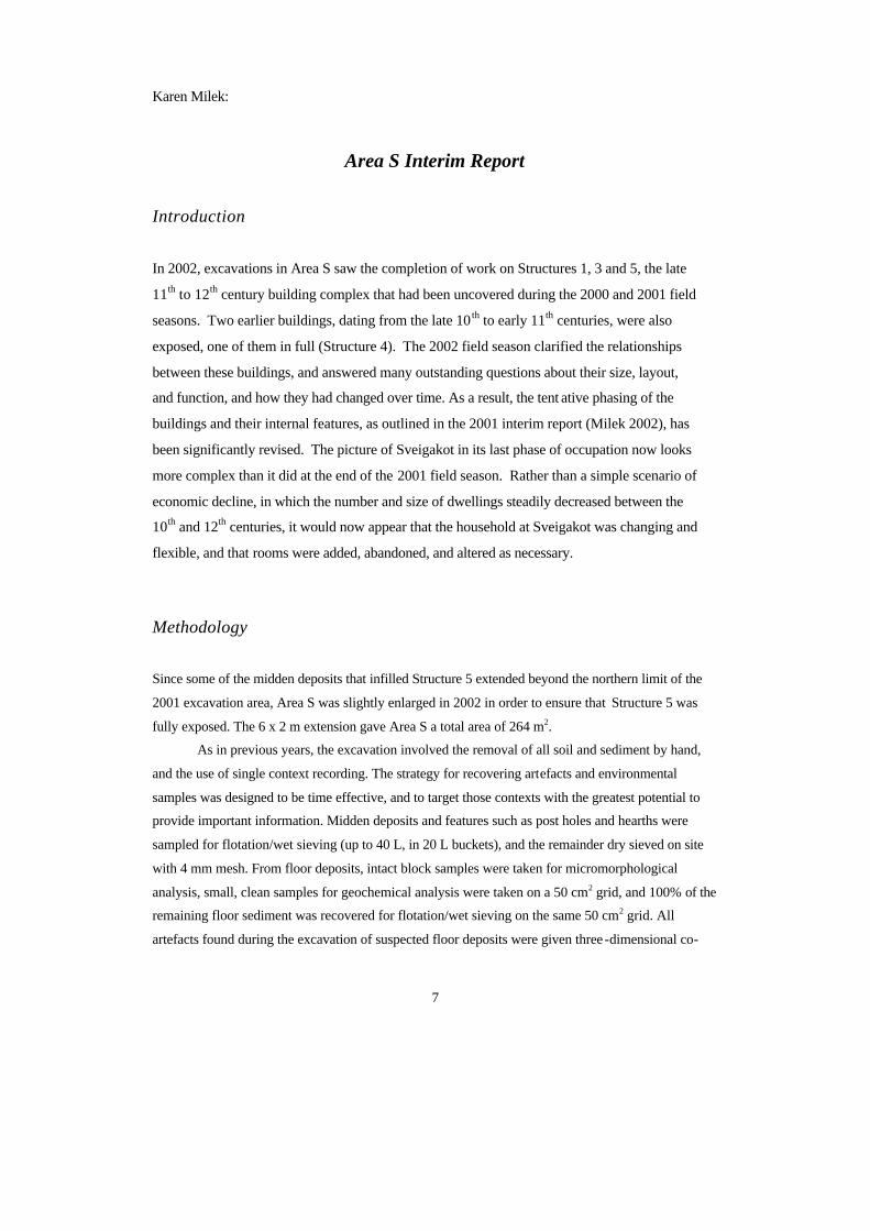
simply the first of two phases of hearth construction (see Figure 1).
Figure 1. Sveigakot Area S, Phase V, showing Structures 1, 2, 3 and 5.
The construction of hearth 796 first involved the digging of a rectangular, vertical-sided pit
(cut 804), which measured c. 140 x 60 cm, and was c. 25 cm deep. The hearth was lined with upright
basalt slabs and included a partially lined ember pit on its eastern end. The upright stones were
packed in place with sediment that appeared to consist of a mixture of the natural yellow subsoil and
the black floor deposit that had been truncated by the pit (context 940). The hearth was filled with
light grey wood ash, abundant charcoal, and calcined bones (context 797), which had been left in situ
when hearth 669 was built on top of hearth 796. The question of why it was necessary or desirable to
alter the original shape of the hearth is an interesting one. Christian Keller (pers. comm .) suggests that
this structural alteration might have been related to a change in the size of the wood available for fuel,
with a V-sectioned hearth more appropriate for thinner timbers.
Structure 2
An occupation deposit and layer of turf collapse associated with a building north of Structure 1 were
excavated on the eroded western edge of the site in 2000 and 2001. These have already been
described in the earlier interim reports.
Structure 3
Structure 3 abuts the eastern end of Structure 1. Becaus e most of Structure 1 was excavated in 2000,
while Structure 3 was not fully exposed until 2001, the occupation deposits within these two buildings
were excavated out of phase. In the 2001 interim report, the occupation of Structure 3 was attributed to
the earlier Phase II, but a re-examination of context plans and photographs from the two earlier field
seasons, and further work in 2002, has shown that Structures 1 and 3 were in fact contemporary. There
is a doorway between the two buildings. The floor of Structure 1 (context 559) tongued out towards
this entrance, and the stone pavement in Structure 3 (context 624) ran from this entrance, across the
central east-west axis of the building. It is likely that the pavement reached another door on the
eastern side of Structure 3, but the loss of the eastern wall to wind erosion makes it difficult to confirm
this.
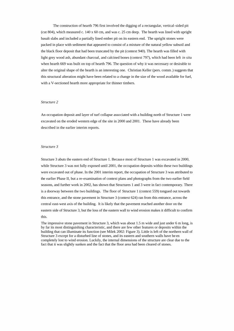
The impressive stone pavement in Structure 3, which was about 1.5 m wide and just under 6 m long, is by far its most distinguishing characteristic, and there are few other features or deposits within the building that can illuminate its function (see Milek 2002: Figure 3). Little is left of the northern wall of Structure 3 except for a disturbed line of stones, and its eastern and southern walls have be en completely lost to wind erosion. Luckily, the internal dimensions of the structure are clear due to the fact that it was slightly sunken and the fact that the floor area had been cleared of stones.
12
Figure 2. Structure 5, facing south, showing floor 854. The location of the hearth can be seen on the right (west) side of the building, but the cooking pit on the east side of the building is still covered by the black floor deposit. Floor 854 had extended over the barrel pit in the south part of the building, but was removed in error during the 2000 field season. Note that the area within the structure is clear of stones.
Internally, Structure 3 had measured approximately 4.5 x 7.5 m, with a strip of floor space about 1.5 m
wide on the north and south sides of the stone pavement.
Better preserved buildings with a central stone pavement have been found on other Viking
Age sites in Iceland, such as Þórarinsstaðir (Hrumannaafréttur), Lundur (Borgarfjarðarsýsla), Gröf
(Öræfi), Hvítárholt (Árnessýsla), Sámsstaðir (Þjórsárdalur), and Herjólfsdalur (Vestmanneyjar). Such
buildings have been interpreted as cattle byres based on the additional evidence of preserved stall
divisions. Possible stall divisions in Sveigakot Structure 3 may be suggested by the lo cations of flat
stones on either side of the pavement, but this interpretation remains difficult to confirm. Nevertheless,
the most plausible interpretation of Structure 3 is that it was a cattle byre; if so, it could have housed
six to eight animals.
One of the most puzzling characteristics of Structure 3 is that it has proven difficult to identify
a floor layer associated with the stone pavement. In the 2001 interim report, it was suggested that the
black, charcoal-rich deposit (context 676/847) beginning to be uncovered in the north and east parts of
Structure 3 could be a floor layer contemporary with the pavement, and it was hoped that the
13
excavation and chemical analysis of this layer would contribute to an understanding of the building’s
function. However, excavations in 2002 revealed that this black floor deposit actually predated the
stone pavement, and was associated with an earlier, domestic phase of the building (see the discussion
on Structure 6, below).
The main layer between the peaty turf roof collapse (context 625/682; see Phase VI) and the
earlier black floor deposit was context 679, a very firm, dark brown silt, with lenses of grey tephra and
oxidised iron. Since this layer was principally composed of turf fragments and soil, it was originally
interpreted as a layer of turf debris associated with the collapse of Structure 3 (Milek 2002: 17).
However, this interpretation has been reconsidered in light of the fact that there are no other
candidates for a floor layer, and the fact that context 679 had surrounded the stone pavement and
lipped up over the edges of it, and was therefore located precisely where one would expect a floor
deposit to be. There are a couple of other unusual characteristics about context 679, most notably the
quantity of large iron nodules it contained. Lenses of oxidised iron containing silt-sized and sand-sized
iron nodules are common in turf building materials taken from wet areas. However, context 679 had
contained extremely large, gravel-sized iron nodules, which were so unusual that they were hand
collected during excavation (2001 sample 35). Iron nodules of this size, which form under repeated
cycles of wetting and drying, have not been observed in any other context at Sveigakot, which
suggests that context 679 was subjected to exceptional environmental conditions. The occurrence of
wetting and drying cycles in Structure 3 prior to the collapse of the roof (context 682) supports the
cattle byre interpretation. Although it may initially seem surprising that the fl oor of the putative cattle
byre was composed of turf rather than straw, the practice of using turf as bedding material is not out of
place in the Norse North Atlantic, and such bedding was frequently used to manure the infield
(Simpson 1997).
Below context 679 and above the black floor deposit belonging to the earlier phase of the
building (Structure 6, context 847) were a number of small patches of mixed turf debris, soil and
decomposed organic matter, often containing charcoal fragments (contexts 879, 893, 905, 906, 910,
913, 914, 939, 941). These belong to the patchy floor deposit associated with the occupation of the
putative byre. In addition, a layer of decomposed organic matter, likely to be decomposed hay or
straw, was excavated east of the pavement (context 892). This layer, in addition to many of the small
turf patches and the main floor deposit, 679, were sampled for soil chemistry. It is hoped that an
evaluation of the phosphate levels in these layers, in comparison to other floor sediments and natural
soils at Sveigakot, will provide additional evidence that Structure 3 was a byre. 1
Structure 5
In 2002, Structure 5 was fully excavated, and the phasing of the building was clarified. Unfortunately,
the stratigraphic relationship between Structures 1 and 5 remains very poor: the occupation deposits
14
within the buildings do not overlap, and severe wind erosion around Structure 5 removed not only the
historic soils (i.e. those above the Landnám tephra sequence) north and east of the building, but also
all evidence of turf walls. The relationship between Structure 5 and the rest of the building complex
has therefore had to be interpreted on the basis of somewhat more spurious evidence, such as internal
features and occupation deposits that indicate the presence of connecting doorways. Luckily, a series
of good radiocarbon dates on domestic animal bone from the upper floor deposits Structure 1 and the
midden capping the floor of Structure 5 supports the interpretation that the two buildings were
contemporary2.
Structure 5 went through several changes in function and internal organisation, and was finally
used as a domestic rubbish dump (described in Milek 2001: 57-58). In the 2001 interim report, it was
suggested that the later midden phase was contemporary with Structure 1, but that the earlier phases of
Structure 5 were likely to be contemporary with Structure 4, the house below Structure 1 (see Phase II,
below). However, the exposure of Structure 4 in 2002 revealed no connection between this ear lier
building and Structure 5. On the other hand, the connection between Structures 1 and 5 had been
clearly indicated by the main floor deposit in Structure 1 (context 559), which had tongued out
towards a doorway between the two buildings. Structure 5 therefore appears to have been built as an
addition to Structure 1, and its entire period of use may now be attributed to Phase V. This view is
supported by the fact that there were no turf collapse deposits, aeolian accumulations, or any other
evidence for a period of abandonment between the floor deposits and the midden deposits in Structure
5 that can parallel the clear abandonment phase between Structures 1 and 4.
Although all evidence for turf walls has been eroded away, and many stones have recently
been removed from this area (as discussed under Phase VII), a disturbed line of stones on the east side
of Structure 5 suggests that this wall, at least, had a stone component (see Figure 1). The interior of
Structure 5, like all of the other buildings so fa r excavated at Sveigakot, had been cleared of stones,
but in its first phase of use the turf was not removed from the ground surface. The roof of Structure 5
was supported by posts set on post pads and in shallow post holes (contexts 977, 978, 981, 945, 99 3,
997, 1000, 1014, 1017, 1019, 1025). The depths of these post holes, which reached a maximum of 22
cm, had clearly been limited by the stoniness and compaction of the subsoil, and several post holes
bottomed on large stones. The posts were not very large, most having a diameter within the range of
20-30 cm. During the life of Structure 5, the posts were reset several times, creating clusters of close
and/or overlapping post holes. Up to three overlapping post holes were found in each cluster, and there
was a cluster of seven separate post holes close to the middle of the back wall. In addition, there were
dozens of small stake holes scattered across the floor in the northern half of the building (e.g. context
976). These formed no recognisable pattern and it is not possible to determine their original function.
Structure 5 was first used as a pantry, or búr. A large, circular, flat-bottomed barrel pit (cut
606) was dug into the natural ground surface and lined with coarse alluvial sand (context 589). During
the use of the barrel, a white organic residue (context 602) seeped out of the bottom and created a
15
narrow ring (2-5 cm wide) in the sand. Later, the function of Structure 5 changed. The barrel was
removed and the barrel pit went out of use, though the grey sand in the barrel pit was left in situ.
Structure 5 was then used as a kitchen, and during this phase the types and locations of the fire
installations changed several times. The floor of the northern half of the building was deturfed, a
process that stripped off the greenish-grey tephra thought to date to c. 950 AD from the northern edge
of the barrel pit. On the eastern side of the building, a narrow, oval cut with a V-shaped section (cut
963) was dug, apparently to hold a stone setting for one side of a hearth. This hearth was later
dismantled, the stones were removed, and cut 963 was filled with mixed upcast and occupation debris
(fill 958) when the earlier hearth was replaced by a cooking pit (954) in the same location. This small,
well-made cooking pit was oval in plan (36 x 48 cm), with nearly vertical sides and a bowl -shaped
base (15 cm deep). Its sides and base were lined with flat lava stones (context 956), which were
packed into place with a very mixed brown and dark greyish brown sediment (context 957). There
were two distinct fills within the pit: a lower fill consisting of grey wood ash, abundant charcoal and
calcined bone fragments (context 951), and a mixed upper fill containing lenses of black and grey ash,
dark brown silt, and coarse alluvial sand (context 950).
Eventually the cooking pit in Structure 5 went out of use, and a hearth or oven was
constructed on the west side of the building in a shallow, oval cut (1007). The base of this hearth/oven
was lined with two flat lava stones surrounded by fist-sized cobbles (context 1009). The feature
probably had upright lava stones on three sides as well (in the manner of the ovens in the Area T pit
house), for large, soot-stained flat lava stones were found in the midden fill immediately above this
feature. The base of the hearth/oven was filled with grey wood ash and charcoal, which spread out into
the interior of Structure 5 and had a diffuse boundary with the laminated floor deposit (context 854;
see Figure 2). This floor deposit, which capped the earlier cooking pit and barrel pit, consisted of
numerous, inseparable lenses of greyish brown sand and black sandy silt, but was not particularly
compact. This is one reason why, when the portion capping the southern part of the barrel pit w as
excavated in 2000, it was assumed to be the lowermost layer of the midden deposit that had infilled
the building after its abandonment. Even though its laminated bedding structure was observed (and
worried about) at the time, it was not possible to identify the layer as a floor deposit until the
excavation area was extended and the entire floor layer and the other features associated with the post -
barrel pit phase of the building were exposed. Micromorphology samples were taken from a small
baulk that ran from the barrel pit to the north end of the building, and it is hoped that the analysis of
these samples will further elucidate the various functions of Structure 5 and how they changed over
time.
16
Phase IV: Use of the domestic structure between major occupation phases
Between the major occupation phases represented by Structures 1 and 4, a number of small occupation
deposits accumulated, which indicate that the building – or its ruin – was occasionally used for some
type of domestic activity. Most of the deposits attributed to this intervening phase, when the ruins may
have been used as a temporary shelter, or a shieling, were excavated in 2001 (see Milek 2002: 15 -16).
During the 2002 field season, the last remaining deposits associated with this phase were excavated on
the west end of the building. These consisted of a small charcoal dump (context 938) and ashy
deposits containing a few fragments of charcoal and bone (contexts 839 and 936). These lay on top of
Structure 4 occupation deposits and turf collapse debris belonging to earlier phases.
Phase III: Abandonment and collapse of Structure 4
The uppermost layers of turf debris from the collapse of Structure 4 were excavated in 2001 (see
Milek 2002: 16), and during the 2002 field season, the excavation of this phase was completed. Due
to concern about the potential difficulty of distinguishing the base of the southern turf wall of
Structure 4, layers of turf debris were not lumped together but defined and peeled off one by one, a
strategy that proved to be reliable and effective. The turf layers varied in their colours and
‘cleanliness’, with many containing small amounts of charcoal, degraded wood fragments, patches of
decomposed organic matter, and/or bone fragments (e.g. contexts 875, 878, 902, 912, 932, 942, 946,
947, 952, 955, 959, 962, 983, 987, 990, 991). Many of these turf layers, as well as the ‘cleaner’ ones,
which were free of anthropogenic inclusions (contexts 643, 953) contained dark reddish brown lenses
of oxidised iron and lenses of dark grey or greenish-grey tephra.
The most distinctive layer of turf collapse was context 648, an extensive layer dominated by
red oxidised iron and black charred organic matter. When the south edge of context 648 was partially
exposed in 2001, the abundance of the charred component led to it being incorrectly described as a
‘blackened occupation surface’ in the 2001 interim report (Milek 2002: 18). However, when it was
excavated in 2002, it became clear that the charred organic matter within this sediment did not form a
surface, but was intimately mixed within the layer in the form small, irregular, intertwining lenses
(many not horizontal), in the same way that tephra and organic matter is frequently lensed within turf
collapse. In addition, there were no wood charcoal fragments, bone fragments, or any other type of
anthropogenic inclusions within context 648, negative evidence that supports its interpretation as turf
collapse rather than an occupation surface. The charred component was silt-sized, and did not include
any white or grey ash. It must therefore have derived from the charring of the grass component of the
turf under very low temperatures and/or reducing conditions. Context 648 may best be interpreted as
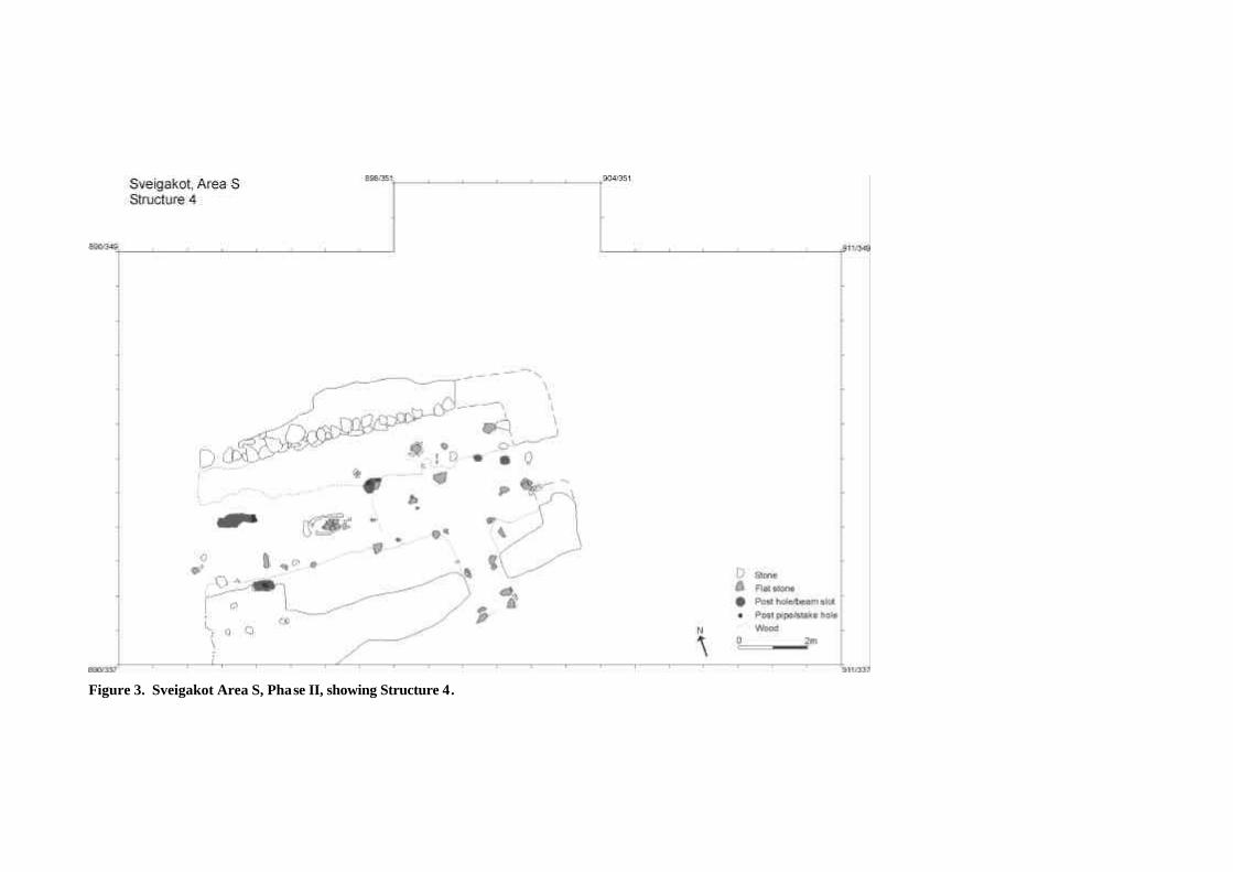
Figure 3. Sveigakot Area S, Phase II, showing Structure 4.
turf roof collapse, which had experienced charring during the occupation of Structure 4, when soot and
cinder drifted up into the roof.
A couple of unusual turf deposits in the south east corner of Structure 4 are also tentativ ely
assigned to this phase. Below the sandy, mixed turf collapse layer 817, which was excavated in 2001,
was a small deposit of very dark greyish brown and dark yellowish brown sandy turf (context 984).
Below this was another small deposit containing lens es of yellowish brown turf and charcoal-stained
silt (context 1008). Both of these unusual turf layers infilled a small depression in the south east corner
of Structure 4, and their removal revealed a layer of pinkish-brown organic matter at the bottom of the
depression. It seems likely that there is a negative feature in the south east corner of Structure 4, but
the origins of this depression and its relationship with the floor of Structure 4 are issues that are not yet
fully understood, and will have to be clarified in 2003.
Within the door in the south wall of Structure 4, aeolian sand accumulated in the wind -trap
created by the open doorway (context 633). This layer of homogenous fine sand contained some
degraded wood fragments, a common inclusion within and outside of the doorway that is likely to
have derived from the collapse of wooden structural elements. Context 633 had a diffuse boundary
with an extensive layer of mixed aeolian silt and turf collapse south of Structure 4 (context 686), and it
is likely that the two layers accumulated at the same time. The fact that context 686 also contains
some occupation debris, such as bone fragments, iron objects, a fire-cracked stone, and 38 pieces of
iron slag (more than any other context so far excavated at Sveigakot) illustrates again that some
activity continued on the site while the south wall of Structure 4 was collapsing (see Phase IV).
Phase II: Occupation of Structure 4 in the late 10 th and 11th centuries
Structure 4, the house below Structure 1, was fully exposed during the 2002 field season, but its
internal occupation deposits have yet to be excavated (see Figures 3 and 4). Like Structure 1, the long
axis of Structure 4 was oriented east-west, and its western end wall had been eroded away by the flood
waters of the Kráká river. The western edge of the main floor deposit in Structure 4 (context 561) had
also been truncated by erosion. If the hearth had been centred, it would mean that 3 m have been lost
from the western end of the building. Therefore, although Structure 4 survives to a length of 12 m, it
can be assumed that 1-3 m have been lost from its western end. Structures 1 and 4 shared the same
north wall (wall 607), but the south long wall of Structure 4 was about 1.5 m further south (wall 1015),
making the earlier house 4.8 m wide. There is an entrance in the south wall about 1.6 m from the
eastern end wall.
When Structure 4 was built, the ground was deturfed, and the area was cleared of stones, a
procedure which stripped off the greenish-grey tephra thought to date to c. 950 AD. This tephra layer,
19
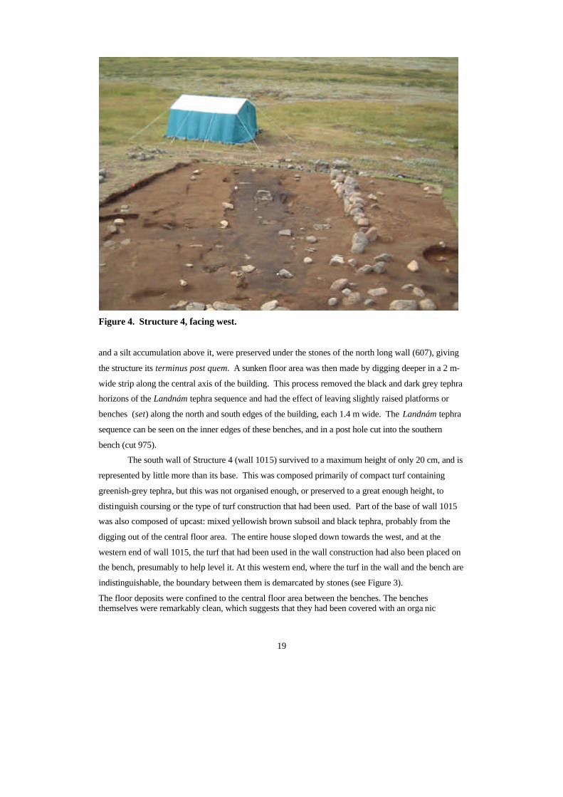
Figure 4. Structure 4, facing west.
and a silt accumulation above it, were preserved under the stones of the north long wall (607), giving
the structure its terminus post quem. A sunken floor area was then made by digging deeper in a 2 m-
wide strip along the central axis of the building. This process removed the black and dark grey tephra
horizons of the Landnám tephra sequence and had the effect of leaving slightly raised platforms or
benches (set) along the north and south edges of the building, each 1.4 m wide. The Landnám tephra
sequence can be seen on the inner edges of these benches, and in a post hole cut into the southern
bench (cut 975).
The south wall of Structure 4 (wall 1015) survived to a maximum height of only 20 cm, and is
represented by little more than its base. This was composed primarily of compact turf containing
greenish-grey tephra, but this was not organised enough, or preserved to a great enough height, to
distinguish coursing or the type of turf construction that had been used. Part of the base of wall 1015
was also composed of upcast: mixed yellowish brown subsoil and black tephra, probably from the
digging out of the central floor area. The entire house sloped down towards the west, and at the
western end of wall 1015, the turf that had been used in the wall construction had also been placed on
the bench, presumably to help level it. At this western end, where the turf in the wall and the bench are
indistinguishable, the boundary between them is demarcated by stones (see Figure 3).
The floor deposits were confined to the central floor area between the benches. The benches themselves were remarkably clean, which suggests that they had been covered with an orga nic
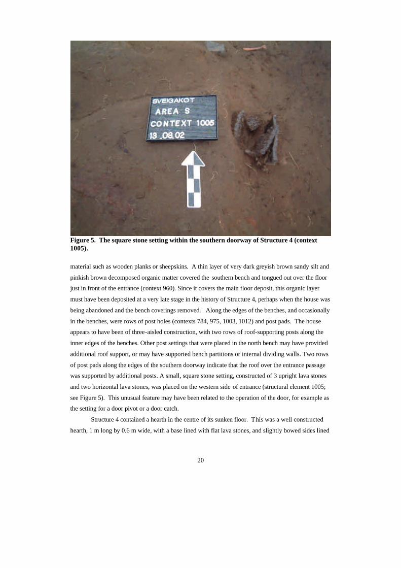
20
Figure 5. The square stone setting within the southern doorway of Structure 4 (context 1005).
material such as wooden planks or sheepskins. A thin layer of very dark greyish brown sandy silt and
pinkish brown decomposed organic matter covered the southern bench and tongued out over the floor
just in front of the entrance (context 960). Since it covers the main floor deposit, this organic layer
must have been deposited at a very late stage in the history of Structure 4, perhaps when the house was
being abandoned and the bench coverings removed. Along the edges of the benches, and occasionally
in the benches, were rows of post holes (contexts 784, 975, 1003, 1012) and post pads. The house
appears to have been of three-aisled construction, with two rows of roof-supporting posts along the
inner edges of the benches. Other post settings that were placed in the north bench may have provided
additional roof support, or may have supported bench partitions or internal dividing walls. Two rows
of post pads along the edges of the southern doorway indicate that the roof over the entrance passage
was supported by additional posts. A small, square stone setting, constructed of 3 upright lava stones
and two horizontal lava stones, was placed on the western side of entrance (structural element 1005;
see Figure 5). This unusual feature may have been related to the operation of the door, for example as
the setting for a door pivot or a door catch.
Structure 4 contained a hearth in the centre of its sunken floor. This was a well constructed
hearth, 1 m long by 0.6 m wide, with a base lined with flat lava stones, and slightly bowed sides lined
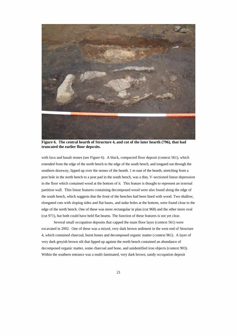
21
Figure 6. The central hearth of Structure 4, and cut of the later hearth (796), that had truncated the earlier floor deposits.
with lava and basalt stones (see Figure 6). A black, compacted floor deposit (context 561), which
extended from the edge of the north bench to the edge of the south bench, and tongued out through the
southern doorway, lipped up over the stones of the hearth. 1 m east of the hearth, stretching from a
post hole in the north bench to a post pad in the south bench, was a thin, V-sectioned linear depression
in the floor which contained wood at the bottom of it. This feature is thought to represent an internal
partition wall. Thin linear features containing decomposed wood were also found along the edge of
the south bench, which suggests that the front of the benches had been lined with wood. Two shallow,
elongated cuts with sloping sides and flat bases, and stake holes at the bottom, were found close to the
edge of the north bench. One of these was more rectangular in plan (cut 968) and the other more oval
(cut 971), but both could have held flat beams. The function of these features is not yet clear.
Several small occupation deposits that capped the main floor layer (context 561) were
excavated in 2002. One of these was a mixed, very dark brown sediment in the west end of Structure
4, which contained charcoal, burnt bones and decomposed organic matter (context 961). A layer of
very dark greyish brown silt that lipped up against the north bench contained an abundance of
decomposed organic matter, some charcoal and bone, and unidentified iron objects (context 903).
Within the southern entrance was a multi-laminated, very dark brown, sandy occupation deposit
22
(context 989) that tongued inwards over floor 561. This contained lenses of charcoal -stained silt, as
well as charcoal flecks, and a small amount of decomposed wood and organic matter (c. 1%), most of
which was concentrated outside of the door. Just within the doorway, in the south east corner of
Structure 4, was a related layer containing flecks and lenses of pinkish brown decomposed organic
matter, lenses of very dark brown silt, and a charcoal lens (context 982). Contexts 989 and 982 shared
a concentration of water-worn pebbles just within the eastern side of the doorway, indicating that they
were contemporary. Since it is not possible for these pebbles to have been deposited natura lly, they
must have been deposited by the occupants of the house, though their original function is difficult to
determine.
Phase I: Pre-structural anthropogenic deposits
This phase of Area S was described in the 2001 interim report (Milek 2002: 20 -21). No new
information about this phase was acquired during the 2002 field season.
Structure 6: A new building
At the end of the 2002 field season, an earlier building phase was discovered below Structure 3, the
putative byre. The black, charcoal-rich floor deposit, context 847, was originally thought to encircle
and lip up over the stone pavement in Structure 3, and was therefore assumed to be associated with it
(Milek 2002: 18). However, when context 847 began to be excavated, it soon became clear that the
layer continued underneath the paving stones, which were pressed down into it. On the south side of
the pavement, where a patch of floor 847 had been slightly more grey and ashy, it turned out to be
capping the ashy fill (context 1021) of a small hearth that was partially underneath the stones of the
pavement (hearth 1022). This hearth, and the black floor deposit 847, are therefore associated with an
earlier, domestic phase of a building that was later converted into a byre. Time did not permit the
removal of the stone pavement during the 2002 field season, so this earlier building, Structure 6, has
yet to be fully exposed. Only when the last remains of Structure 3 have been excavated, and the
relationship between Structure 6 and the rest of the settlement complex is clarified, will it be possible
to know if Structure 6 should be placed in Phase II (with Structure 4), or in Phase V (with Structure 1).
Conclusion
During the 2002 field season, the total number of structures in the Area S building complex was
brought up to six. Other than Structure 6, which has yet to be fully exposed, the relationships between
these structures were clarified, and it is now possible to trace the changing sequence of buildings and
23
building functions from the late 10th through the 12th centuries. Many ideas about this building
sequence, and what it means for the interpretation of the economic status of the farm, have had to be
revised on the basis of this new information.
The earliest house, Structure 4, was constructed in the second ha lf of the 10th century. With its
slightly bowed long walls, an entrance on one side of the southern long wall, a central hearth, three -
aisle construction, and low side benches, it was a skáli of traditional Viking Age form. Having
internal dimensions of c. 5 x 12-15 m, it rested comfortably within the average size for Viking Age
rural houses in the north Atlantic region. For some reason the building fell out of use at some point in
the 11th century. Aeolian sands accumulated within the entrance, and the w alls partially collapsed –
particularly the southern long wall. Sporadic occupation of the building, or its ruin, took place during
this period of abandonment, and it is not unlikely that the site was used as a temporary shelter or a
shieling at this time.
When Area S came to be intensively occupied again in the late 11 th century, the north wall of
Structure 4 was incorporated into the new house, Structure 1, but otherwise the new building was
constructed following a very different design. The new southe rn wall was built on what had been the
inner edge of the south bench of Structure 4, reducing the width of the building to just under 4 m. Its
main entrance was moved – presumably to the western end of the south long wall, where it has been
lost to erosion. A new hearth was built approximately 1 m north of the earlier one, which reflected the
new central axis of the narrower building. At a later point in the life of Structure 1, this hearth was
remodelled, and its original rectangular section was replaced with a V-shaped one. Structure 1 did not
contain raised side benches of earthen materials, but the hour -glass plan of the main floor deposit
suggests that wooden benches had been placed in a central location along each of the long walls.
Structure 1 was the main dwelling structure in this 11 th to 12th century building complex, and
probably functioned in a similar way as the earlier skáli (i.e. a room for sleeping, cooking, eating, and
sitting). However, at least one smaller, more specialised building was attached to this main building,
giving it a form that may have resembled the 12 th-century building complexes that have been
excavated in the Þjórsárdalur, in south Iceland. Structure 5, which first functioned as a pantry and
later as a kitchen, abutted the north side of Structure 1, and was linked to the main house by a door on
the eastern end of the northern long wall. Structure 2 is so close to the north side of Structure 1 that it
could also have been attached, but the evidence for this has been eroded away by the floodwaters of
the Kráká River. Structure 3, a byre with a central stone pavement, was attached to the eastern end of
the main house.
The final occupation phase of Sveigakot is therefore more complex than had previously been
envisioned. Although the size of the skáli was reduced between the 10th century and the 11th/12th
century occupation phases, at least one small domestic building with more specialised functions was
added to the skáli during the later phase. Also, the function of this small building was altered
constantly throughout its use, reflecting the flexibility and the changing needs of the household. The
24
change in the design of the dwelling house between the 10 th and 11th centuries, hitherto attributed only
to economic decline, could therefore be related to a number of other factors. The addition of the
Structure 5 to Structure 1 (if indeed it was built later, rather than at the same time) could, for example,
be interpreted as reflecting the later growth of a household that was originally quite small. An
alternative perspective is that the spatial organisation of the later dwelling complex, in which Structure
5 was added and given more specialised functions, was intended to spatially separate certain
household activities (e.g. dairy production and cooking). Such spatial differentiation within houses,
also a trait of the 12th century houses of the so-called Þjórsárdalur type, could be interpreted as a sign
of increased social differentiation among household members (Kent 1990). The remodelling of the
hearth in Structure 1, and the frequent alterations made to Structure 5, could also be taken as an
indication of a high rate of change in the household, and perhaps a certain level of instability. This
view is supported by the micromo rphological evidence from the floor of Structure 1: freeze -thaw soil
structures have been observed in the middle of the floor deposit, which could have been produced by
the abandonment of Structure 1 for one or more winters (Milek, forthcoming). How the a pparent
spatial differentiation and instability of the 11 th to 12th century occupation phase compares to the
earlier 10th century phase is an interesting issue that can only be addressed once Structures 4 and 6
have been fully excavated.
Notes 1 Unfortunately, because it had appeared to be a layer of turf collapse and was not recognised as a floor deposit
when it was excavated in 2001, context 679 was not bulk sampled on a 50 cm 2 grid, or sampled for
micromorphological analysis.
2 2 sigma calibrated dates on domestic cattle and caprine bone from the upper floor layer of Structure 1 (context
558): AD 1020-1200 (Beta 154783), AD 1060-1270 (Beta 154784), AD 1020-1200 (Beta 154785); 2 sigma
calibrated dates on domestic cattle bone from midden deposits cappin g the floor of Structure 5 (contexts 767 and
692): AD 1040-1290 (AA-52495; GU-9734), and AD 1020-1220 (AA-52496; GU-9735).
Acknowledgements
Many thanks are due to the excellent team who worked on the excavation of Area S in 2001:
Guðrun Alda Gisladóttir, Jeppe Skovby, and Mette Svinding. I am also grateful for the help
and high spirits of Magda Natuniewicz-Sekuta, Orri Vésteinsson, Premyslaw Urbanczyk, and
Robert Zukowski.
25
Bibliography
Kent, S. (1990) A cross-cultural study of segmentation, architecture, and the use of space. In
S. Kent (ed.), Domestic Architecture and the Use of Space: An Interdisciplinary, Cross -
Cultural Study, 127-152. Cambridge University Press. Cambridge.
Milek, Karen (2001) Area S interim report. In Orri Vésteinsson (ed.) , Archaeological
Investigations at Sveigakot 1998-2000, pp. 50-65. Reykjavík: Fornleifastofnun Íslands.
Milek, Karen (2002) Sveigakot 2001. Area S – Long house. In Orri Vésteinsson (ed.),
Archaeological Investigations at Sveigakot 2001 , pp. 8-28. Reykjavík: Fornleifastofnun
Íslands.
Orri Vésteinsson (2001) Archaeological investigations at Sveigakot. Introduction. In Orri
Vésteinsson (ed.), Archaeological Investigations at Sveigakot 2001 , pp. 43-49. Reykjavík:
Fornleifastofnun Íslands.
Simpson, Ian (1997) Relict properties of anthropogenic deep top soils as indicators of infield
management in Marwick, West Mainland, Orkney. Journal of Archaeological Science 24:
365-380.
26
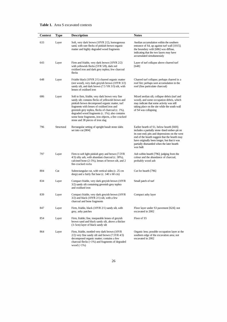
Table 1. Area S excavated contexts
Context Type Description Notes 633 Layer Soft, very dark brown (10YR 2/2), homogenous
sand, with rare flecks of pinkish brown organic matter and highly degraded wood fragments
Aeolian accumulation within the southern entrance of S4, up against turf wall [1015]; the boundary with [686] was diffuse, indicating that the two layers may have accumulated simultaneously
643 Layer Firm and friable, very dark brown (10YR 2/2)
with yellowish flecks (5YR 5/8), dark red oxidised iron and dark grey tephra; few charcoal flecks
Layer of turf collapse above charred turf [648]
648 Layer Friable black (10YR 2/1) charred organic matter
(not wood), very dark greyish brown (10YR 3/2) sandy silt, and dark brown (7.5 YR 3/3) silt, with lenses of oxidised iron
Charred turf collapse; perhaps charred in a roof fire; perhaps soot accumulation in the roof (fine particulate charcoal)
686 Layer Soft to firm, friable, very dark brown very fine
sandy silt; contains flecks of yellowish brown and pinkish brown decomposed organic matter, turf fragments with lenses of oxidised iron and greenish grey tephra, flecks of charcoal (c. 1%), degraded wood fragments (c. 1%); also contains some bone fragments, iron objects, a fire-cracked stone and 38 pieces of iron slag
Mixed aeolian silt, collapse debris (turf and wood), and some occupation debris, which may indicate that some activity was still taking place on the site while the south wall of S4 was collapsing
796 Structural Rectangular setting of upright basalt stone slabs
set into cut [804] Earlier hearth of S1, below hearth [669]; includes a partially stone-lined ember-pit on its east end; pits and depressions on the west end of the hearth suggest that the hearth may have originally been longer, but that it was partially dismantled when the later hearth was built
797 Layer Firm to soft light pinkish grey and brown (7.5YR
4/3) silty ash, with abundant charcoal (c. 30%), calcined bone (2-5%), lenses of brown silt, and 2 fire-cracked rocks
Ash within hearth [796]; judging from the colour and the abundance of charcoal, probably wood ash
804 Cut Subrectangular cut, with vertical sides (c. 25 cm
deep) and a fairly flat base (c. 140 x 60 cm) Cut for hearth [796]
834 Layer Compact friable, very dark greyish brown (10YR
3/2) sandy silt containing greenish grey tephra and oxidised iron
Small patch of turf
839 Layer Compact friable, very dark greyish brown (10YR
3/2) and black (10YR 2/1) silt, with a few charcoal and bone fragments
Compact ashy layer
847 Layer Firm, friable, black (10YR 2/1) sandy silt, with
grey, ashy patches Floor layer under S3 pavement [624]; not excavated in 2002
854 Layer Firm, friable; fine, inseparable lenses of greyish
brown sand and black sandy silt, above a thicker (3-5cm) layer of black sandy silt
Floor of S5
864 Layer Firm, friable, mottled very dark brown (10YR
2/2) very fine sandy silt and brown (7.5YR 4/3) decomposed organic matter; contains a few charcoal flecks (<1%) and fragments of degraded wood (<1%)
Organic lens; possible occupation layer at the southern edge of the excavation area; not excavated in 2002
27
867 Layer Yellowish turf containing black tephra, on southern edge of excavation
Possible turf wall or wall collapse; not excavated in 2002
868 Layer Turf containing grey-green tephra, on the
southern edge of S4 wall [1015] Possible turf wall or wall collapse; not excavated in 2002
869 Layer Grey sand Aeolian sand below [867] and [868]; not
excavated in 2002 870 Layer Dark brown silt with pink-brown organic matter
around the large boulder SE of S4 Organic deposit; not excavated in 2002
871 Layer Very firm, light pinkish brown organic matter on
S edge of the excavation, adjacent to [867] Organic deposit; not excavated in 2002
875 Layer Firm, friable, mottled dark brown (10YR 2/2) and
very dark greyish brown (10YR 3/2) fine sand, containing reddish turf fragments and charcoal flecks (<1%)
Above cleaner turf collapse layer [643]; probably part of the same collapse phase
876 Layer Friable, dark brown (10YR 2/2) fine sandy silt
with charcoal staining Charcoal-stained lens on the south edge of hearth cut [804], and apparently truncated by that cut
878 Layer Firm, friable, mottled very dark grey (10YR 3/1),
very dark greyish brown (10YR 3/2) and dark reddish brown (5YR 3/4) very fine sandy silt, containing charcoal flecks (<1%), bone (<1%), and degraded wood fragments (<1%)
Turf collapse between floors [561] and [599], with some occupation debris at the sandier bottom of the layer; the wood fragments may be structural, and the layer probably represents roof collapse
879 Layer Very firm and friable very dark greyish brown
(10YR 3/2) very fine sandy silt, with patches of pinkish-brown (7YR 4/3) decomposed organic matter (5-10%)
Organic-rich deposit east of pavement [624] in S3
880 Layer Firm, friable, dark greyish brown sandy silt
around stones on the E edge of S5 Above floor [854]; appears to be a thin accumulation of aeolian sand deposited prior to the turf collapse [814]
892 Layer Firm, plastic, dark brown (7.5YR 3/4) organic silt
(50-60%), and very dark greyish brown (10YR 3/2) sandy silt, with some charcoal flecks (<1%)
Organic deposit on the east end of pavement [624] in S3; possible hay layer
893 Layer Firm, friable, very dark brown (10YR 2/2) silt (c.
50%), mottled with dark yellowish brown (10YR 4/4) very fine silty sand (10-20%), and very dark greyish brown (10YR 3/2) organic silt and oxidised iron (c. 30%); charcoal flecks (<10%)
Small deposit of turf collapse under the larger turf collapse layer [679] and attributed to the same phase
901 Layer Soft, friable black (10YR 2/1) silty sand
containing c. 50% wood charcoal, including some very large pieces
Small charcoal dump on the E edge of S5; on its SE edge, the layer was partially overlain by natural yellow silt of the subsoil, which had slumped down from the primary edge/cut of the building
902 Layer Friable, very dark brown (10YR 2/2) and dark
brown (10YR 3/2) sandy silt with charcoal flecks and some bone fragments
Layer of turf collapse above charred turf layer [648]
903 Layer Compact, friable to plastic, very dark greyish
brown (10YR 3/2) silt, with pinkish brown (7.5YR 3/3) decomposed organic matter (20-30%), and occasional flecks of strong brown (7.5YR 5/8); contains some charcoal (<1%), bone fragments, and unidentified iron objects
Occupation deposit within S4
904 Layer Firm, friable black (10YR 2/1) sandy silt and Charcoal and ash dump in S5
28
grey to dark grey silty ash; contains abundant charcoal (c. 50%) and small fragments of burnt bone
905 Layer Firm, friable, very dark yellowish brown (10YR
3/4) mottled with very dark brown (10YR 2/2) and oxidised iron (c. 5%)
Small turf deposit in S3
906 Layer Firm, friable, mottled very dark greyish brown
(10YR 3/2) and dark brown (10YR 3/3) sandy silt, with oxidised iron (c. 5%), and some charcoal fragments
Small turf deposit in S3
909 Layer Firm, friable, black (10YR 2/1) and dark brown
(10YR 3/3) sandy silt Small deposit of charred turf in S3
910 Layer Firm, friable, dark brown (10YR 3/3) sandy silt
and decomposed organic matter (<30%) with charcoal flecks (<1%) and iron oxide (<1%)
Small deposit of turf and organic matter in S3
911 Layer Firm, friable, dark brown (10YR 3/3) silty sand Aeolian sand deposit above the floor in S5 912 Layer Firm, friable, very mixed deposit, consisting
mainly of very dark brown (10YR 2/2) sandy silt, greenish grey tephra (c. 5%), pinkish-brown decomposed organic matter (<1%), and charcoal flecks (<1%)
Turf deposit above the floor [561], and associated with the collapse of S4
913 Layer Firm, friable, very dark greyish brown (10YR
3/2) and dark yellowish brown (10YR 3/6) sandy silt
Small turf deposit in S3
914 Layer Firm, friable, dark brown (10YR 3/3) silty sand
with greyish green tephra and oxidised iron; contains some charcoal (<1%)
Small turf deposit in S3
929 Layer Firm, friable, mottled deposit, consisting mainly
of very dark greyish brown (10YR 3/2) organic sandy silt, with flecks of oxidised iron and light yellow silt
Small dump on top of the main floor deposit in S5
930 Cut Oval, shallow (10 cm deep) cut/depression with
sloping sides and a nearly flat base; contains 5 small stones
Shallow post setting in S4
932 Layer Firm, friable, very dark greyish brown (10YR
3/2) mottled with dark brown (10YR 3/3) and very dark brown (10YR 2/2) silty sand with some charcoal flecks (<1%)
Mixed turf and soil on top of floor [561] in S4
936 Layer Friable, very dark brown (10YR 2/2), dark
greyish brown (10YR 3/2) and dark reddish brown (5YR 3/4) sandy silt; contains 2 pieces of bone
Reddish sandy deposit between ash deposit [839] and charcoal deposit [938] on the W of S1/4; these appear to have been deposited between the main occupation sequences
937 Fill Soft, friable, very dark brown (10YR 2/2)
homogenous silt; a large stone was set on the sloping N edge of the cut
Fill at the bottom of the post hole [945] in S5
938 Layer Friable, black (10YR 2/1) and very dark brown
(10YR 2/2) silt containing abundant charcoal (60-70%) and bone fragments
Small charcoal dump on the W end of S1/4
939 Layer Firm, friable, dark brown (10YR 3/3) mottled
with dark yellowish brown (10YR 3/4) silty sand, oxidised iron (c. 5%) and charcoal flecks (c. 1%)
Small layer of turf, which partially overlapped paving stones [624]
29
940 Fill Firm, friable; very mixed sediment, containing black (10YR 2/1) and very dark grey (10YR 3/1), and dark yellowish brown (10YR 3/4) silt; contains abundant charcoal (c. 30%)
Packing around the upright stone slabs of hearth [796], infilling cut [804]; appears to be composed of a mixture of the S4 floor deposit [561], and the natural yellow subsoil, both of which had been truncated in the digging of cut [804]
941 Layer Firm, friable, very dark greyish brown (10YR
3/2) sandy silt with c. 5% patches of black (10YR 2/1) and oxidised iron (c. 7%); contains some charcoal (c. 2%) and small pieces of bone
Small layer of turf in S3
942 Layer Firm, friable, mixed very dark brown (10YR 2/2)
and very dark greyish brown (10YR 3/2) very fine sandy silt, with abundant flecks of pinkish brown (7.5YR 4/4) decomposed organic matter (c. 30%); contains some charcoal (<2%)
Small turf layer from the collapse of S4, above floor layer [561]
945 Cut Rectangular cut with rounded corners, a flat base,
vertical E and W edges, and sloping N and S edges
Post setting in S5, around which floor [854] had accumulated; the bottom of the cut was filled with [937], and the remainder with midden material, indicating that the post had been removed when S5 was abandoned
946 Layer Firm, friable, very dark brown (10YR 2/2) and
very dark greyish brown (10YR 3/2) silt; contains degraded wood fragments, charcoal, bone, iron slag, an iron nail, an iron rivet, and a spindle-whorl
Thick deposit of turf and soil above floor [561] in S4; contains some occupation debris, which may perhaps be attributed to the sporadic occupation of the ruin between the main structural phases of S4 and S1; the northern edge of this deposit was truncated by the cut for the hearths in S1
947 Layer Firm, friable, dark brown (10YR 3/3) sandy silt
with some charcoal pieces (<1%), oxidised iron (<1%), greenish grey tephra, and a small patch of pinkish brown organic matter (<1%)
Small layer of turf collapse in the E end of S4, above floor [561]
950 Fill Mixed lenses of black/grey sandy silt, dark brown
greyish sandy silt; also contains a patch of subrounded medium to very coarse sand
The upper fill of cooking pit [954]
951 Fill Grey ash containing pieces of charcoal (c. 10%)
and bone Lower fill of cooking pit [954]
952 Layer Firm, friable, dark yellowish brown (10YR 3/4)
silty sand containing oxidised iron (c. 5%) and some organic matter (<1%)
Small turf deposit above the S bench of S4
953 Layer Firm, friable, dark yellowish brown (10YR 3/4)
silty sand mottled with black tephra and oxidised iron (c. 2%)
Small turf deposit above the S bench of S4
954 Cut Oval cut with nearly vertical, slightly
undercut/slumped sides, and a bowl-shaped base Cut of cooking pit
955 Layer Firm, friable, dark yellowish brown (10YR 3/4)
mottled with very dark brown (10YR 2/2) sandy silt; contains oxidised iron (c. 2%), black tephra (c. 7%), greenish grey tephra (c. 3%), decomposed organic matter (c. 2%), degraded wood fragments (c. 1%), and charcoal pieces (<1%)
Small deposit of turf collapse within the S doorway of S4
956 Structural Stone lining of cooking pit, consisting of 4 flat
lava stones arranged around a natural rock at the base of the cut, one large flat lava stone on the south side of the cut, and several smaller stones on the north side of the cut
Stone lining of cooking pit [954]
30
on the north side of the cut 957 Fill Firm, friable, very mixed brown and very dark
greyish brown sandy silt, with some charcoal pieces (c. 1%)
Packing around the stones lining cooking pit [954]
958 Layer Firm, friable, very mixed brown and dark greyish
brown sandy silt, and tephra; contains some charcoal (c. 2%) and bone
Possibly upcast from the digging of cooking pit [954]
959 Layer Firm, friable, dark brown (10YR 3/3) silty sand
containing lenses of pinkish brown organic matter and some pieces of charcoal (<1%)
Small deposit of turf and organic matter within the S doorway of S4
960 Layer Firm, friable, very dark greyish brown (10YR
3/2) sandy silt, with pinkish brown decomposed organic matter (c. 20%) and some oxidised iron (c. 5%)
Mixed layer of soil and decomposed organic matter that stretched over the S bench of S4, and covered floor [561] just in front of the S doorway
961 Layer Friable, very dark brown (10YR 2/2) sandy silt
containing some charcoal, burnt bones, and decomposed organic matter
Mixed occupation deposit in the W end of S4, just above floor [561]
962 Layer Friable, dark brown (10YR 3/3) sandy silt, with c.
1% charcoal Small deposit of turf above floor [561] in S4
963 Cut Narrow, oval cut with sloping sides and a V-
shaped base Cut probably for the stone setting for one side of a hearth; stones were dismantled and removed, and the cut was infilled with upcast [958], which was created during the digging of cooking pit [954]
964 Layer Friable, very dark greyish brown (0YR 3/2) sandy
silt containing grey tephra and one iron nail Small deposit of turf in S4, which can probably be lumped with [936]
965 Fill Firm, friable, black (10YR 2/1) and dark brown
(10YR 3/3) silt with come charcoal (<1%) and organic matter (<1%)
Fill of the narrow rectangular cut [968];
966 Fill Friable, very dark brown (10YR 2/2) sandy silt
containing some degraded wood fragments Fill of small post hole [967], on the E end of the narrow rectangular cut [968]
967 Cut Small rectangular cut with rounded corners,
vertical sides, 2 rounded depressions at the base Small post hole, which may have contained 2 stakes; filled with [966]; on E end of [968]
968 Cut Shallow rectangular cut with rounded corners,
sloping sides, and a flat base Filled with [965]; seems to have held a flat beam associated with the stake(s} in [967]; feature could be associated with the edge of the N bench of S4
969 Fill Firm, friable, very mixed fill, consisting of very
dark greyish brown (10YR 3/2) mottled with dark yellowish brown (10YR 3/4) silty sand, and small patches of greenish grey and black tephra (c. 1%)
Fill of post hole [975] in the S bench of S4
970 Fill Friable, very dark brown (10YR 2/2) sandy silt
containing some charcoal (<1%) and burnt bone Fill of shallow oval depression [971]
971 Cut Shallow oval cut with sloping sides and a fairly
flat base; more rounded base on the E end; 3 rounded depressions at the base
Filled with [970]; could have held a flat beam and/or stakes; feature could be associated with the edge of the N bench in S4
973 Fill Firm, friable, mixed greyish brown and yellowish
brown (subsoil) sandy silt; some charcoal (0.5%) Fill of post hole [977] in S5
974 Fill Firm, friable, very dark grey sandy silt; contained
one piece of bone and a piece of unworked red sandstone
Fill of stake hole [976] in S5

31
sandstone 975 Cut Oval cut with vertical sides on the N, S, and E,
and a sloping side on the W; base is bowl-shaped, with a small shelf on the E end
Cut for post hole in the S bench of S4; filled with [969]
976 Cut Small oval cut with nearly vertical sides and a
rounded base Cut for stake hole in S5, filled with [974]
977 Cut Oval cut, with vertical sides and a fairly flat base;
two natural, flat stones are protruding at the base Post hole in S5, filled with [973]
978 Cut Oval cut with 3 vertical sides and a sloping S
side, and a rounded base Post hole in S5, filled with [979]
979 Fill Firm, friable, very mixed black, greyish brown
and brown sandy silt; contains some charcoal (c. 1%)
Fill of post hole [978] in S5
980 Fill Firm, friable, mixed greyish brown, brown and
dark greyish brown sandy silt; some charcoal (c. 0.5%)
Fill of post hole [981] in S5
981 Cut Oval cut with nearly vertical sides and a rounded
base Post hole in S5, filled with [980]
982 Layer Firm, friable, very dark greyish brown (10YR
3/2) sandy silt with flecks and lenses of pinkish brown (7.5YR 4/4) decomposed organic matter, and lenses of very dark brown (10YR 2/2) silt; contains a charcoal lens (c. 5% of the layer) and a cluster of pebbles just within the doorway
Mixed soil and organic matter, very much like [960], deposited in the SE corner of S4, just within the doorway
983 Layer Friable, mixed very dark brown (10YR 2/2), dark
yellowish brown (10YR 3/4) and black (10YR2/1) sandy silt
Mixed/disturbed turf deposit next to post pad in the N part of S4
984 Layer Firm, friable, mottled very dark greyish brown
(10YR 3/2) and dark yellowish brown (10YR 3/4) silty fine sand; contains charcoal flecks (<1%)
Small deposit of what appears to be sandy turf, filling a depression in the SE corner of S4
985 Fill Firm, friable, very dark brown (10YR 2/2) silty
sand, containing some charcoal (c. 1%) and iron slag
Fill of post hole [992], south of the pavement in S3
986 Layer Firm, friable, dark greyish brown sandy silt;
contains some charcoal (c. 0.5%) Small occupation deposit under the main floor layer [854] in S5
987 Layer Firm, friable, dark brown (7.5YR 3/3), very dark
brown (10YR 2/2), dark yellowish brown (10YR 4/4) and black (10YR 2/1) organic silt
Small, thin organic lens on the N edge of the cut west of the S1 hearth
988 Layer Firm, friable, very mixed dark greyish brown,
brown, black and grey sand and sandy silt; some charcoal (c. 5%), bone and burnt bone
Small layer of mixed upcast material in S5, which turned out to be a series of overlapping post hole fills (944, 996, 1001, 1013, 1024)
989 Layer Firm, friable, very dark brown (10YR 2/2) very
fine sandy silt with lenses of charcoal-stained silt (10YR 2/1); contains charcoal flecks (<1%), a few small turf fragments containing oxidised iron, degraded wood fragments and decomposed organic matter (<1%), an iron nail, a couple of pieces of slag, and some pebbles
Lensed, sandy occupation deposit in the S entrance of S4, and stretching inwards over floor [561]; most organic matter and wood inclusions were more highly concentrated outside of the door
990 Layer Firm, friable, very mixed dark brown (7.5YR 3/4 Small deposit of mixed turf on the N bench
32
and 10YR 3/3) and strong brown (7.5YR 4/6) sandy silt
of S4; possibly a last remnant of S4 collapse debris
991 Layer Firm, friable, very mixed dark brown (7.5YR 3/4
and 10YR 3/3) and strong brown (7.5YR 4/6) sandy silt
Small deposit of mixed turf on the N bench of S4; possibly a last remnant of S4 collapse debris
992 Cut Round cut, with vertical sides and a sloping base
caused by the presence of a large stone on one side
Cut of post hole in S3, filled with [985]
993 Cut Oval cut, with vertical sides and a rounded base Post hole in S5, filled with [994] 994 Fill Firm, friable, mixed dark greyish brown, brown,
greyish ash, and black tephra; contains some charcoal and burnt bone fragments
Fill of post hole [993] in S5; appears to be composed of mixed subsoil, floor deposits and sand
995 Fill Firm, friable, very dark greyish brown (10YR
3/2) mottled with dark yellowish brown (10YR 3/4) silty sand
Fill of small depression/post impression [998] in S3
996 Fill Firm, friable, mixed dark greyish brown, brown,
greyish ash, and black tephra; contains some charcoal and burnt bone fragments
Fill of post hole [997] in S5
997 Cut Oval cut with steep sides to the E and N, a
sloping side to the S, and a rounded base Cut for post hole in S5, filled with [996]
998 Cut Round depression, with sloping sides and a bowl-
shaped base Cut or impression of a small post in S3, filled with [995]
999 Fill Friable, very mixed dark brown (10YR 3/3) and
black (10YR 2/1) sandy silt; contains some charcoal (c. 5%), bone and degraded wood fragments
Fill of post hole [1003] in S4
1000 Cut Oval cut with vertical sides and a rounded base;
on large stone protruded on the W side of the base, and 2 small stones were on the S side of the base
Cut for post hole in S5, filled with [1001]
1001 Fill Firm, friable, very mixed dark greyish brown,
brown, black and grey sand and sandy silt; some charcoal (c. 5%), bone and burnt bone
Fill of post hole [1000] in S5
1002 Layer Firm, friable, very dark greyish brown (10YR
3/2) silty sand with c. 1% charcoal Small sandy deposit in S3 above the ashy fill of hearth [1022]
1003 Cut Irregularly shaped cut, with a square protrusion
on its E side and a more oval shape on its W side; a flat stone/post pad is on the SE edge of the cut
Cut for post hole in S4, filled with [999]; at the N end of the base is post pipe [1011]
1004 Fill Friable, dark brown (10YR 3/3) sandy silt Fill of post pipe [1011], at the bottom of post
hole [1003] in S4 1005 Structural Square setting of lava stones, 3 standing vertical,
2 lying horizontal Located within the S doorway of S4, on its W edge, this feature is opposite a flat stone on the W side of the doorway, and is probably related to the operation of the door itself (e.g. for pivot or vertical catch)
1006 Layer Friable, very dark brown (10YR 2/2) sandy silt Small, thin deposit against the N bench of S4 1007 Cut Shallow oval cut, rather like a triangle with
rounded corners; sloping sides and a flat base Cut for hearth [1009] in W part of S4
1008 Layer Firm, friable, mottled dark yellowish brown Small deposit consisting of lenses of
33
(10YR 3/4) and black (10YR 2/1) very fine sandy silt, containing 2-5% charcoal flecks
yellowish brown turf and charcoal-stained silt, capping an organic layer in a depression in the SE corner of S4
1009 Structural 2 flat lava stones packed around by fist-sized
cobbles form the base of a hearth Hearth against the W wall of S4; the sides were missing, but 2-3 charred flat lava stones found in the midden deposits immediately above the hearth could have been disturbed side stones of the hearth; if so, it would have looked rather like the hearths in the pit house
1010 Fill Friable, very dark grey (10YR 3/1) and very dark
brown (10YR 2/2) sandy silt, with some degraded wood fragments
Fill of post hole [1012] in S4
1011 Cut Round cut with nearly vertical sides and a
rounded base Cut of post pipe at the bottom of post hole [1003] in S4, filled with [1004]
1012 Cut Oval cut with vertical sides and a rounded base Cut of post hole in S4, filled with [1010] 1013 Fill Firm, friable, very mixed brown and dark greyish
brown sandy silt; contains some charcoal and bone
Fill of post hole [1014] in S5
1014 Cut Oval cut with vertical sides and a sloping base Cut of post hole in S5, filled with [1013] 1015 Structural Compact turf contains greenish grey tephra;
preserved to a maximum thickness of 20 cm; not enough height to distinguish coursing; at the W end of the wall, there appears to be strengur, otherwise the turf is not organised enough to identify its type; upcast material consisting of mixed yellowish brown subsoil and black tephra forms part of the base of the wall
Base of south wall of S4; there is an entrance towards the E end of the wall; on its W end, the wall becomes indistinguishable from the bench, and it appears that the same type of turf material was laid on the bench to level it; a row of stones demarcate the boundary between the wall and the bench
1016 Fill Firm, friable, very mixed dark greyish brown
sandy silt and yellowish brown natural subsoil; contains some charcoal (c. 1%)
Fill of post hole [1017] in S5, apparently consisting of mixed floor deposits and natural subsoil
1017 Cut Round cut with nearly vertical sides and a
rounded base Cut of post hole in S5, filled with [1016]
1018 Fill Firm, friable, very mixed dark greyish brown and
brown silty sand; contains some charcoal (0.5%) Fill of post hole [1019] in S5
1019 Cut Round cut with vertical sides and a rounded base;
there is a natural stone protruding from the subsoil in the W side of the base
Cut of post hole in S5, filled with [1018]
1021 Layer Firm, friable, mixed black and light grey silt
(ash), with some lenses of brown fine sandy silt; contains charcoal, burnt bone, and 1 piece of slag
Ashy fill of hearth [1022], below the S3 pavement; belongs to an earlier phase of the building (S6); only partially excavated in 2002
1022 Structural Flat lava stones and fist-sized cobbles form the
base of a hearth; the soil below has been oxidised red by burning
Discovered below pavement [624] and a layer of mixed turf on the last day of the excavation; not excavated in 2002
1023 Fill Dark greyish brown sandy silt Fills of the many stake holes in S5; not
excavated in 2002 1024 Fill Firm, friable, very mixed dark greyish brown,
brown, black and grey sand and sandy silt; some charcoal (c. 5%), bone and burnt bone
Fill of post hole [1025] in S5
1025 Cut Oval cut with vertical sides and a rounded base Cut of post hole in S5, filled with [1024]
34
Przemyslaw Urbanczyk
Area T - excavation report for 2002
The summer of 2002 was the third and the final season of excavating features discovered at
the southern edge of the Sveigakot deserted farm. Exploration of the area which started in
2000 was first limited to a 50x50 cm test-pit that was later increased to the size of a 5x5 m
trench. When it was realized that the trench contained unexpectedly rich stratification,
excavation was terminated until the following summer when the trench (enlarged to 5x9 m)
was “given” to a Polish team under the lead of the present author. Results of the 2001
excavation are summarized in the interim report – cf. Urbanczyk 2002.
In 2002 we managed to complete the field work (Fig. 1) within the trench that
contained remains of two Viking Age sunken buildings. While the method of excavation was
the same as in 2001, we introduced an innovative system of digitized recording, which
allowed production of a more precise and ready-to-publish documentation. Due to the small
size of both buildings and the fact that only their underground elements survived aeolian
deflation, exploration of the cultural layers was not an especially demanding task. However,
the number of identified contexts resulted in relatively long recording-time, while the very
small size of the stratigraphic units demanded precise excavation and observation of minute
traits.
Stratigraphic data collected during the two excavation seasons allows us to attempt a
reconstruction of the early “history” of the Sveigakot farm. So far this story has no beginning
because the first dwelling has not yet been discovered. The older of the two identified
constructions was not a dwelling structure but some farm building of an unknown function –
probably a storage house. Thus, the first house, matching the early date suggested by the base
accumulation of the midden area, is still to be found to provide a possibly full pictu re of the
settlement phase.
However, one may intermittently consider an alternative vision of the beginning of the
Sveigakot farm. It is possible that the site was first taken in an agricultural use not as a regular
farm but as an outfield seasonally exploited by some not distant farm. In such a case it was
not necessary to build a solid house because a simple shed could fulfill daily needs while a
more elaborate construction was needed for storing hay and/or dairy products. If this model
was true, the direct occupation would begin somewhat later as an outcome of demographic
pressure, which either pushed some people to resettle to this marginal area, or it limited the
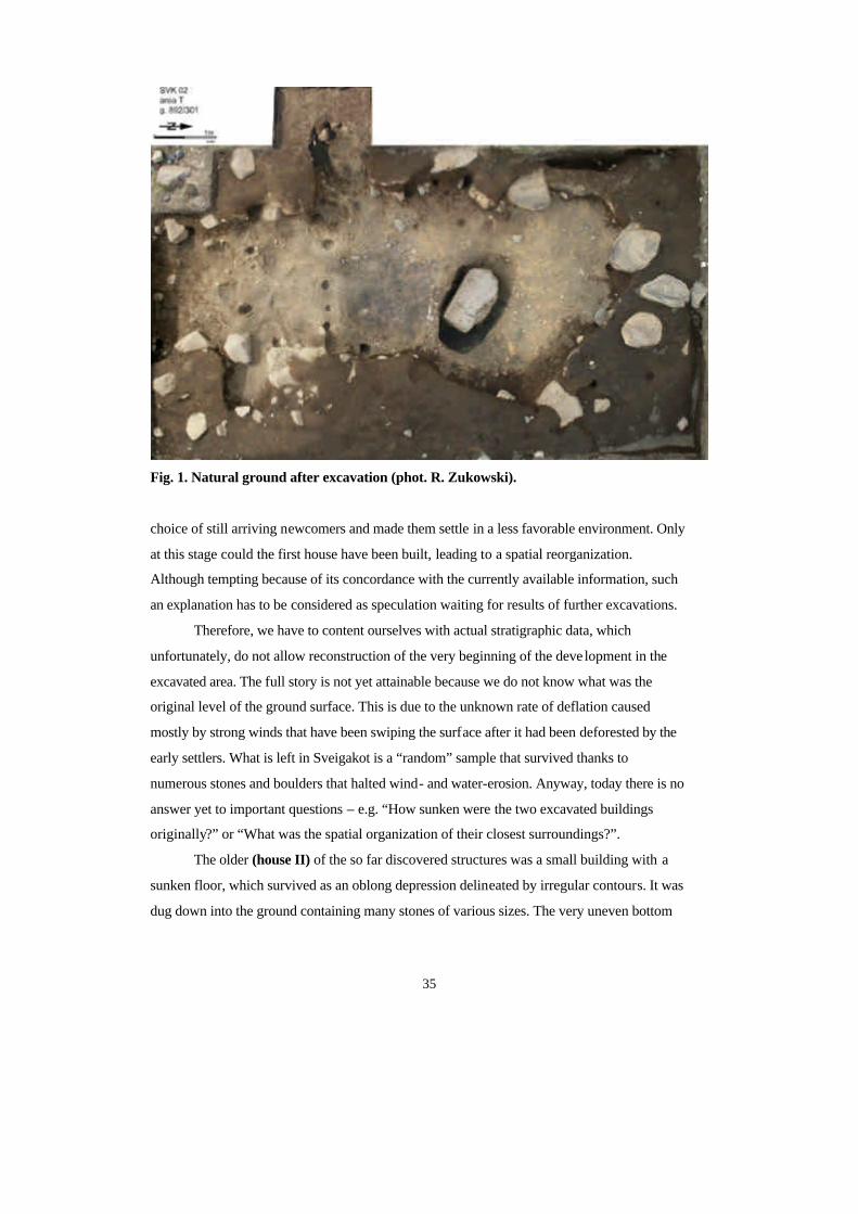
35
Fig. 1. Natural ground after excavation (phot. R. Zukowski).
choice of still arriving newcomers and made them settle in a less favorable environment. Only
at this stage could the first house have been built, leading to a spatial reorganization.
Although tempting because of its concordance with the currently available information, such
an explanation has to be considered as speculation waiting for results of further excavations.
Therefore, we have to content ourselves with actual stratigraphic data, which
unfortunately, do not allow reconstruction of the very beginning of the deve lopment in the
excavated area. The full story is not yet attainable because we do not know what was the
original level of the ground surface. This is due to the unknown rate of deflation caused
mostly by strong winds that have been swiping the surface after it had been deforested by the
early settlers. What is left in Sveigakot is a “random” sample that survived thanks to
numerous stones and boulders that halted wind- and water-erosion. Anyway, today there is no
answer yet to important questions – e.g. “How sunken were the two excavated buildings
originally?” or “What was the spatial organization of their closest surroundings?”.
The older (house II) of the so far discovered structures was a small building with a
sunken floor, which survived as an oblong depression delineated by irregular contours. It was
dug down into the ground containing many stones of various sizes. The very uneven bottom
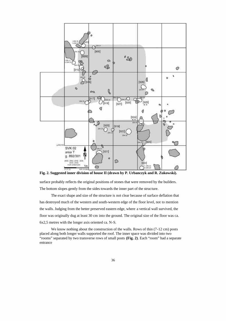
36
Fig. 2. Suggested inner division of house II (drawn by P. Urbanczyk and R. Zukowski). surface probably reflects the original positions of stones that were removed by the builders.
The bottom slopes gently from the sides towards the inner part of the structure.
The exact shape and size of the structure is not clear because of surface deflation that
has destroyed much of the western and south-western edge of the floor level, not to mention
the walls. Judging from the better preserved eastern edge, where a vertical wall survived, the
floor was originally dug at least 30 cm into the ground. The original size of the floor was ca.
6x2,5 metres with the longer axis oriented ca. N-S.
We know nothing about the construction of the walls. Rows of thin (7-12 cm) posts placed along both longer walls supported the roof. The inner space was divided into two “rooms” separated by two transverse rows of small posts (Fig. 2). Each “room” had a separate entrance
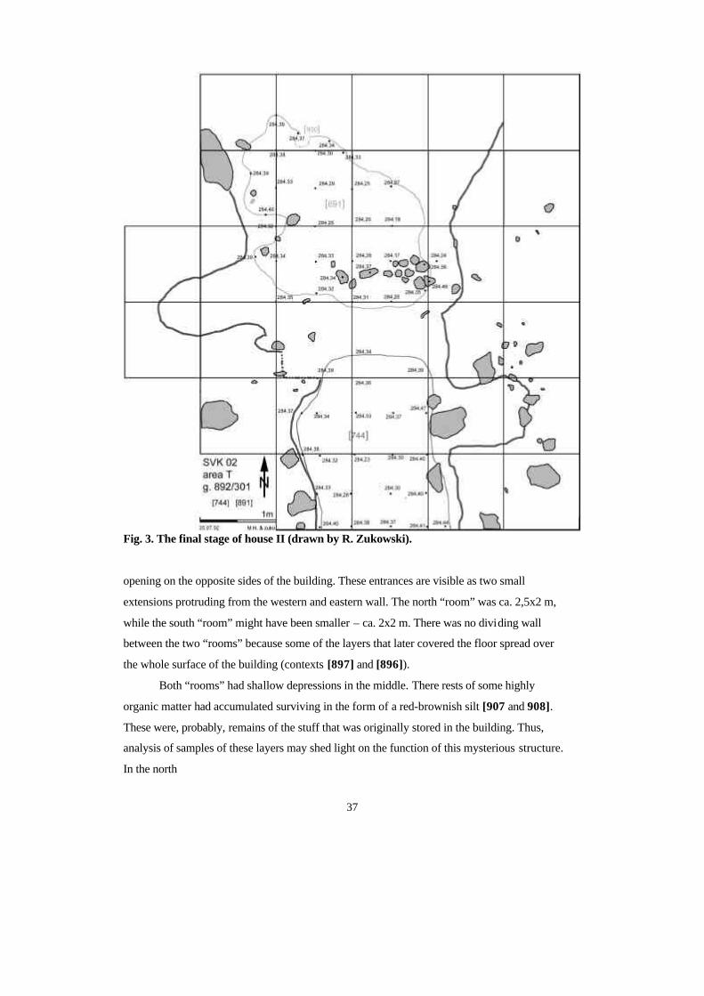
37
Fig. 3. The final stage of house II (drawn by R. Zukowski).
opening on the opposite sides of the building. These entrances are visible as two small
extensions protruding from the western and eastern wall. The north “room” was ca. 2,5x2 m,
while the south “room” might have been smaller – ca. 2x2 m. There was no dividing wall
between the two “rooms” because some of the layers that later covered the floor spread over
the whole surface of the building (contexts [897] and [896]).
Both “rooms” had shallow depressions in the middle. There rests of some highly
organic matter had accumulated surviving in the form of a red-brownish silt [907 and 908].
These were, probably, remains of the stuff that was originally stored in the building. Thus,
analysis of samples of these layers may shed light on the function of this mysterious structure.
In the north
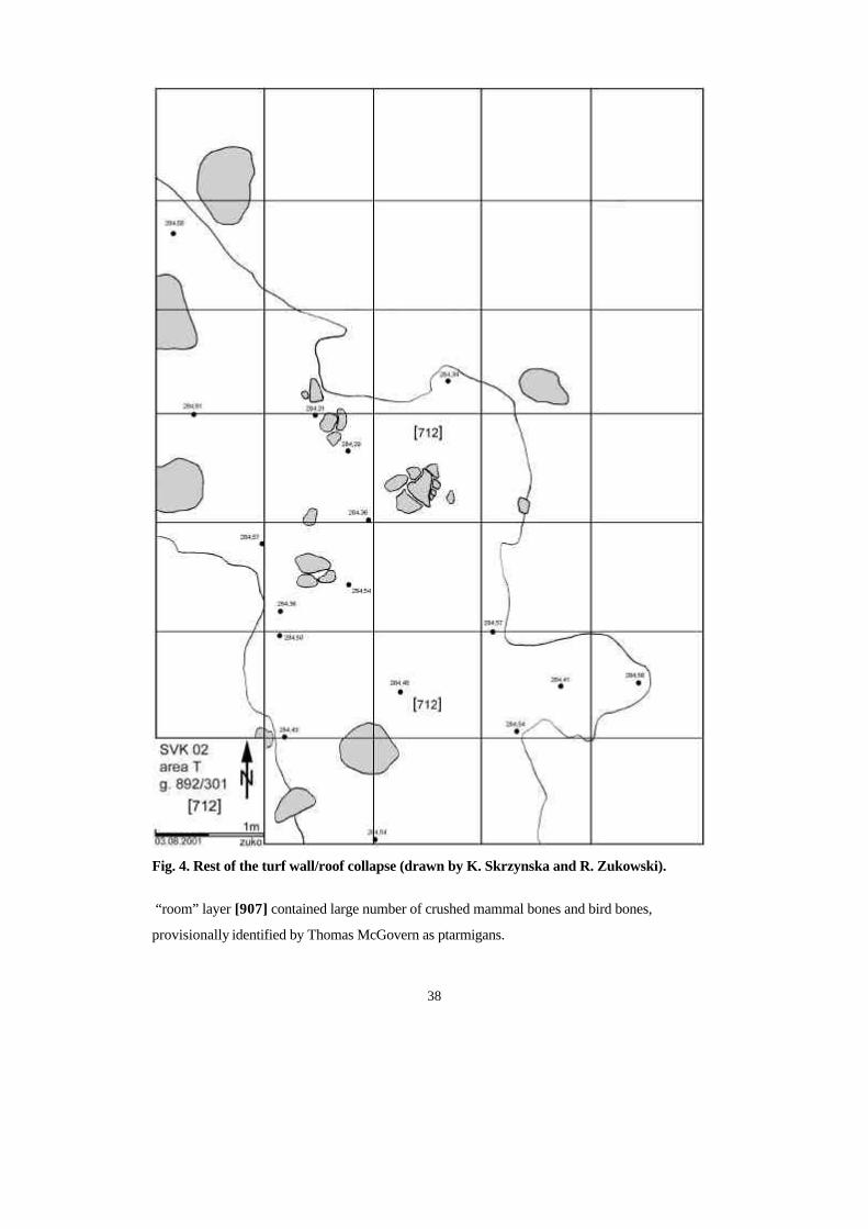
38
Fig. 4. Rest of the turf wall/roof collapse (drawn by K. Skrzynska and R. Zukowski).
“room” layer [907] contained large number of crushed mammal bones and bird bones,
provisionally identified by Thomas McGovern as ptarmigans.
39
Later a layer of brown gravely sand [897] “entered” the building through the western
entrance and covered the southern and western parts of the floor area. A plan of changing the
function of the building (phase 2) started with leveling of the whole interior and both
entrances with a dark brown sandy layer [896]. On this new floor a hearth [895] was placed in
the middle of the north “room”. It was made of two thick flat stones flanked with two other
stones. Intensive use of this heating device is testified by a thick and compact layer of
charcoal and ashes [894]. In this layer some boat-nails and a fish-hook were found, which
suggests burning boat planks, which in turn may point to the lack of burning wood. There
were no indications (e.g. artifacts, compact floor layers) for a permanent habitation. This
suggests that the building was used as a temporary shelter. However, two thin sandy layers
(dark brown silty sand [891] covered with brown sand [890]) subsequently accumulated on
the floor of the north “room”. While this part of the building was actively used, the south
“room” had a visibly different function. It was probably used for storing some organic
material, which survived as a very thin reddish-brown organic silt [744] – Fig. 3.
This building went out of use or suddenly collapsed with its turf roof and/or walls
covering the whole interior and its direct vicinity. A thick layer of mixed turfs [712] survived
only in the depressions while the rest was removed from the surface by eroding wind action
(Fig. 4). Therefore, it is difficult to determine what was the chronological relation of the
grayish-green tephra (V~950) and the building under discussion. This volcanic layer was seen
as thin lenses mixed in the turfs. However, it is not certain whether these turfs were cut when
the tephra already covered the area, or whether the volcanic eruption took place shortly before
the collapse, which resulted in mixing of the ashes in between falling pieces of turf.
Similarly, there is no stratigraphic data to estimate the relative chronology of a large
pit [898] discovered in the north-western part of the trench. This round feature with vertical
walls and flat bottom could have been dug and filled before the mentioned building was
constructed, when the building was in use, or after it collapsed.
Some time later a new structure (house I) was constructed at the northern edge of the
ruin so that it cut through the collapse of the former building. It was a small hut with sub-
rectangular sunken floor oriented ca. NW-SE (phase 1). This orientation might have been
forced by the topography of the area itself. The ground in Sveigakot , full of stones, boulders
and rocks, is very “unfriendly” for people who want to sink their dwellings. It is simply
impossible to find a space free of these natural obstacles. Those who built both excavated
structures must have been driven by a very strong will to have their buildings dug down and
have been ready to invest much time and labour.
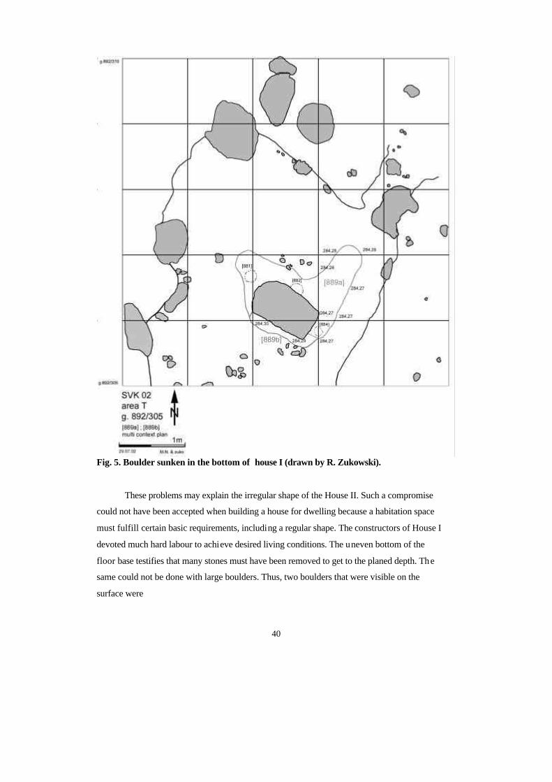
40
Fig. 5. Boulder sunken in the bottom of house I (drawn by R. Zukowski).
These problems may explain the irregular shape of the House II. Such a compromise
could not have been accepted when building a house for dwelling because a habitation space
must fulfill certain basic requirements, including a regular shape. The constructors of House I
devoted much hard labour to achieve desired living conditions. The uneven bottom of the
floor base testifies that many stones must have been removed to get to the planed depth. The
same could not be done with large boulders. Thus, two boulders that were visible on the
surface were
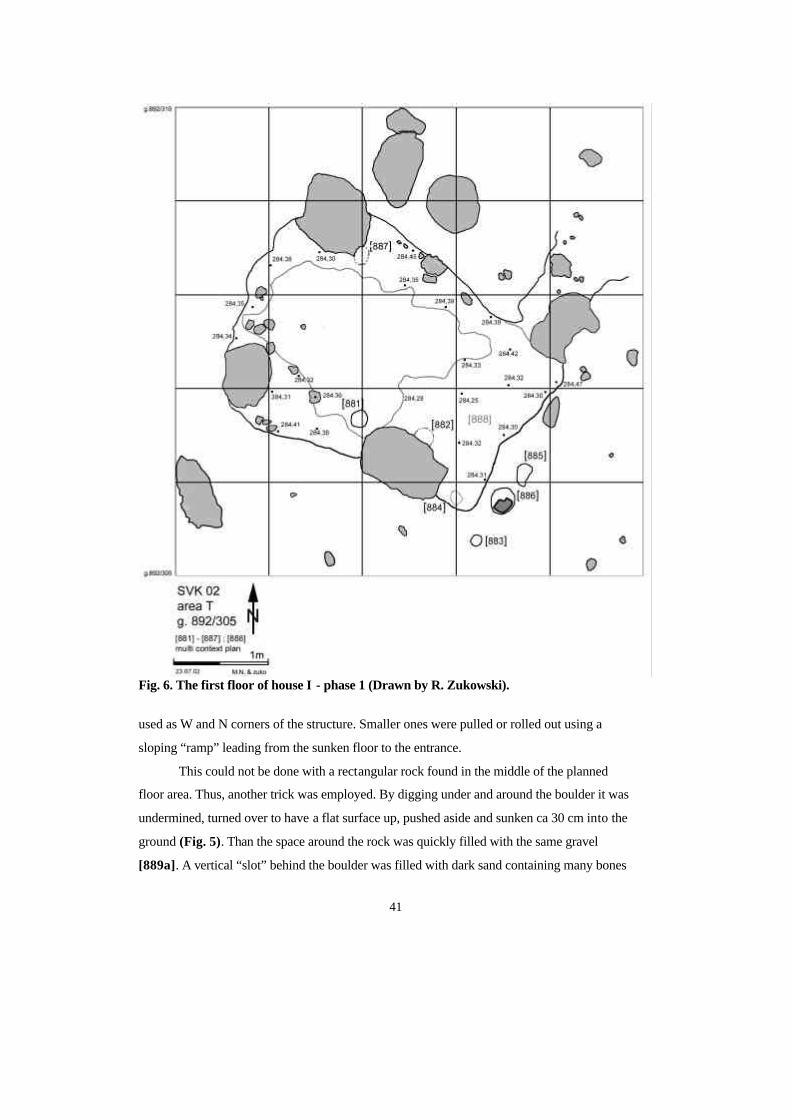
41
Fig. 6. The first floor of house I - phase 1 (Drawn by R. Zukowski).
used as W and N corners of the structure. Smaller ones were pulled or rolled out using a
sloping “ramp” leading from the sunken floor to the entrance.
This could not be done with a rectangular rock found in the middle of the planned
floor area. Thus, another trick was employed. By digging under and around the boulder it was
undermined, turned over to have a flat surface up, pushed aside and sunken ca 30 cm into the
ground (Fig. 5). Than the space around the rock was quickly filled with the same gravel
[889a]. A vertical “slot” behind the boulder was filled with dark sand containing many bones

42
Fig. 7. The second floor of house I – phase 2a (drawn by M. Natuniewicz and R.
Zukowski).
[889b]. The hasty way of filling the pit resulted in open cavities left under the rock. They
were still visible when we emptied the pit.
The flat surface of this boulder sticking up from the floor most probably served as a
useful working “table”. The entrance to the hut was located in its E corner. It was a 60 cm
wide and 120 cm long passage leading to a deep depression discovered in the NE corner of
the trench, where a separate stratigraphic sequence accumulated. This entrance had a separate
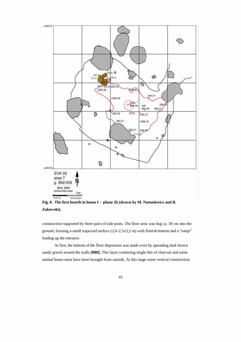
43
Fig. 8. The first hearth in house I – phase 2b (drawn by M. Natuniewicz and R.
Zukowski).
construction supported by three pairs of side posts. The floor area was dug ca. 30 cm into the
ground, forming a small trapezoid surface (2,0-2,5x3,2 m) with flattish bottom and a “ramp”
leading up the entrance.
At first, the bottom of the floor depression was made even by spreading dark brown
sandy gravel around the walls [888]. This layer containing single bits of charcoal and some
animal bones must have been brought from outside. At this stage some vertical construction
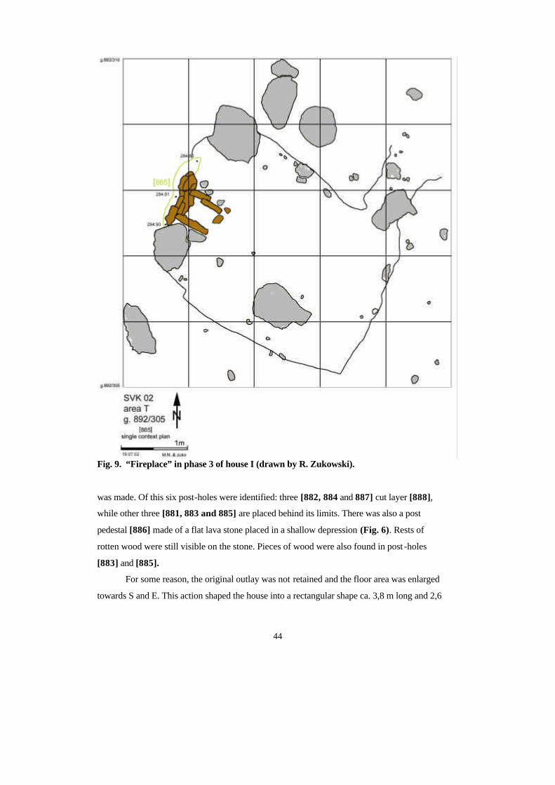
44
Fig. 9. “Fireplace” in phase 3 of house I (drawn by R. Zukowski).
was made. Of this six post-holes were identified: three [882, 884 and 887] cut layer [888],
while other three [881, 883 and 885] are placed behind its limits. There was also a post
pedestal [886] made of a flat lava stone placed in a shallow depression (Fig. 6). Rests of
rotten wood were still visible on the stone. Pieces of wood were also found in post -holes
[883] and [885].
For some reason, the original outlay was not retained and the floor area was enlarged
towards S and E. This action shaped the house into a rectangular shape ca. 3,8 m long and 2,6
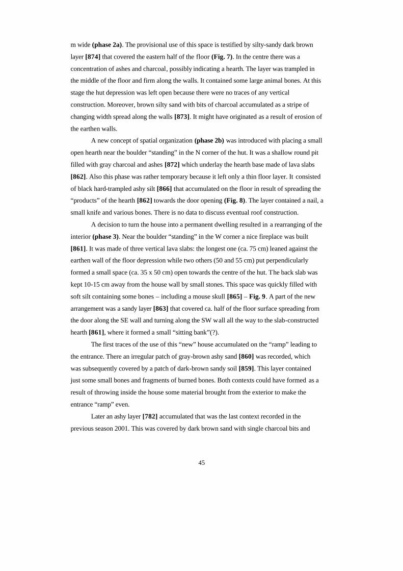
45
m wide (phase 2a). The provisional use of this space is testified by silty-sandy dark brown
layer [874] that covered the eastern half of the floor (Fig. 7). In the centre there was a
concentration of ashes and charcoal, possibly indicating a hearth. The layer was trampled in
the middle of the floor and firm along the walls. It contained some large animal bones. At this
stage the hut depression was left open because there were no traces of any vertical
construction. Moreover, brown silty sand with bits of charcoal accumulated as a stripe of
changing width spread along the walls [873]. It might have originated as a result of erosion of
the earthen walls.
A new concept of spatial organization (phase 2b) was introduced with placing a small
open hearth near the boulder “standing” in the N corner of the hut. It was a shallow round pit
filled with gray charcoal and ashes [872] which underlay the hearth base made of lava slabs
[862]. Also this phase was rather temporary because it left only a thin floor layer. It consisted
of black hard-trampled ashy silt [866] that accumulated on the floor in result of spreading the
“products” of the hearth [862] towards the door opening (Fig. 8). The layer contained a nail, a
small knife and various bones. There is no data to discuss eventual roof construction.
A decision to turn the house into a permanent dwelling resulted in a rearranging of the
interior (phase 3). Near the boulder “standing” in the W corner a nice fireplace was built
[861]. It was made of three vertical lava slabs: the longest one (ca. 75 cm) leaned against the
earthen wall of the floor depression while two others (50 and 55 cm) put perpendicularly
formed a small space (ca. 35 x 50 cm) open towards the centre of the hut. The back slab was
kept 10-15 cm away from the house wall by small stones. This space was quickly filled with
soft silt containing some bones – including a mouse skull [865] – Fig. 9. A part of the new
arrangement was a sandy layer [863] that covered ca. half of the floor surface spreading from
the door along the SE wall and turning along the SW wall all the way to the slab-constructed
hearth [861], where it formed a small “sitting bank”(?).
The first traces of the use of this “new” house accumulated on the “ramp” leading to
the entrance. There an irregular patch of gray-brown ashy sand [860] was recorded, which
was subsequently covered by a patch of dark-brown sandy soil [859]. This layer contained
just some small bones and fragments of burned bones. Both contexts could have formed as a
result of throwing inside the house some material brought from the exterior to make the
entrance “ramp” even.
Later an ashy layer [782] accumulated that was the last context recorded in the
previous season 2001. This was covered by dark brown sand with single charcoal bits and
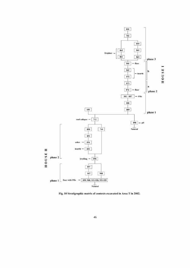
46

47
some bones. This floor context [800] covered almost the wole area of the house. A nice semi-
spheric spindle-whorl made of red sandstone was found near the vertical lava slab that framed
the hearth. A littlebit further south a piece of a whalebone plaque(?) popped up.
This stratigraphic story is illustrated by the matrix showing all recorded contexts in a
relative chronological sequence (Fig. 10). Later events are described in the first interim report
(cf. Urbanczyk 2002).
48
Thomas H. McGovern:
Herding Strategies at Sveigakot, N Iceland: an Interim Report
Abstract: Between 1999-2001 Archaeological Institute Iceland (FSl) excavations at Sveigakot in Mývatnssveit in N Iceland recovered substantial animal bone collections from midden deposits in two main areas of the site (unit M and unit T). Tephra allow phasing of these deposits into three main analytic units (AU 1-3) which roughly correspond to structural phases I, II, and V. The earliest material (AU1, Phase I) was deposited in area M directly upon a forested surface still covered by the Landnám tephra of ca AD 871+/ - 2 and currently represents the oldest datable archaeofauna in N Iceland. A mid 10th c. Veiðivötn tephra (initially given context number 007, labeled SVK tephra “A” in Dugmore and Newton 2003) runs across the area M midden, providing a stratigraphic boundary between lower (AU1) and upper (AU2) midden deposits in th is area. Both AU 1 and 2 produce overlapping radiocarbon dates in the late 9 th-mid 10th centuries AD. After the fall of this Veiðivötn tephra, a small pit house was built to the S of midden area M, and this pit house was later in -filled with midden deposits (AU 3). Radiocarbon dates indicate that the fill of T occurred in the later 11 th- early 12th c. The three midden analytic units show a general decline of cattle from early to late phases, and a marked decline in pig and goat relative to sheep in the latest layers. Aging data suggest that cattle were managed for dairy produce and pigs for meat, but that sheep were (perhaps increasingly) managed primarily for wool production. The Sveigakot archaeofauna represents the first Settlement Period collection large enough for herding strategy reconstruction, and will provide a useful comparison with equally substantial archaeofauna from Hofstaðir and other sites in the region.
Introduction
This interim report provides the first complete quantification of the domes tic mammal bones
from the Sveigakot midden deposits. Wild species (fish, birds, fox) are under study and will
be reported separately in the next interim report. Additional bones were recovered from floor
layers and from a small terminal phase midden in Phase VI, but these have not been included
in the present report to avoid mixing fundamentally different depositional types in the same
analysis (floor deposits vrs middens). Since middens tend to collect refuse from a wide range
of activities and from different original points of deposition around a site, they tend to blur
together the many activities taking place in the course of the year and to conflate and
homogenize the many activities associated with animal and human bone modification
(slaughter, dismemberment, meat preservation, cooking, consumption, craft use, childrens’
play, dog gnawing). For general economic reconstruction, this homogenization is a positive
factor. If sample size and excavation units are large enough midden deposits regularly
produce the best overall view of economic organization on a site and provide the best basis
for inter-site comparison. Smaller concentrations of bone more directly associated with
primary deposition (single butchery event, single meal, small store of meat, bone o r horn
49
working) can greatly contribute to functional interpretation of rooms and features, but are far
more likely to skew an overall economic picture. The main purpose of the current interim
report is to present the complete domestic mammal data and discu ss the implications of the
reconstructed age structure of the archaeofauna. Later reports will present related data on
domestic animal size, butchery, taphonomy, and pathology. Since excavation continues and
site phasing is still being finalized this report will use analytic units (AU) rather than phase or
temporal labels.
Changing Relative Abundance
Table 1 presents the count of all domestic mammal bone fragments from the two analytic
units (AU 1 & 2) from midden M the analytic unit 3 from midden T and the total for all
midden deposits (NISP 8,093). NISP (number of identified specimens) refers to all fragments
that could be identified to a useful level, in this case to species level except for the “caprine”
category. As most bones of sheep and goat skeletons cannot be identified to species,
zooarchaeological analyses produce a substantial number of bones that can be securely
identified as either sheep or goat but not assigned to either species. Thus “caprine” refers to
both these indeterminate fragments and to both species taken together (equivalent to
“ovicaprid” or “O/C” of other workers) when they are collectively compared to cattle, horse,
or pig (all of which are far easier to identify to species level). No dog bones are present in the
collection, but characteristic canine tooth marks are present on a number of bone fragments in
the collection. Where there was evidence of articulation observed in the field or in the
laboratory articulated elements were counted as a single NISP to avoid multiple count s of the
same individual.
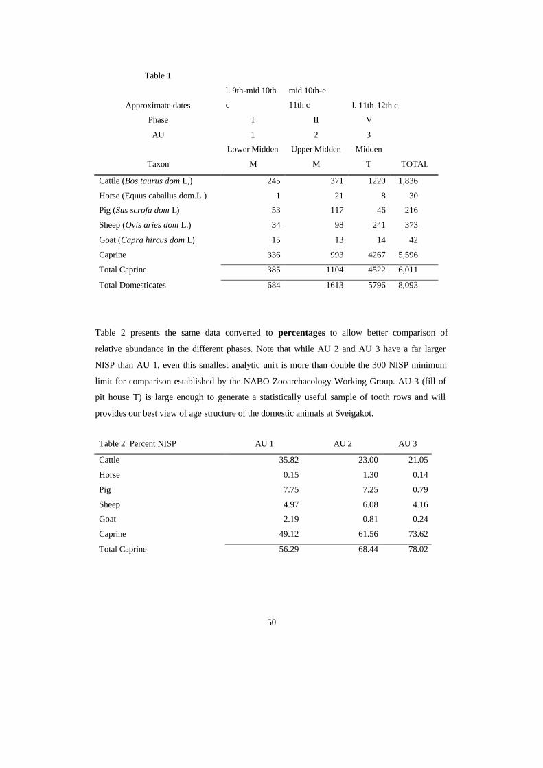
50
Table 1
Approximate dates
l. 9th-mid 10th
c
mid 10th-e.
11th c l. 11th-12th c
Phase I II V
AU 1 2 3
Taxon
Lower Midden
M
Upper Midden
M
Midden
T TOTAL
Cattle (Bos taurus dom L,) 245 371 1220 1,836
Horse (Equus caballus dom.L.) 1 21 8 30
Pig (Sus scrofa dom L) 53 117 46 216
Sheep (Ovis aries dom L.) 34 98 241 373
Goat (Capra hircus dom L) 15 13 14 42
Caprine 336 993 4267 5,596
Total Caprine 385 1104 4522 6,011
Total Domesticates 684 1613 5796 8,093
Table 2 presents the same data converted to percentages to allow better comparison of
relative abundance in the different phases. Note that while AU 2 and AU 3 have a far larger
NISP than AU 1, even this smallest analytic uni t is more than double the 300 NISP minimum
limit for comparison established by the NABO Zooarchaeology Working Group. AU 3 (fill of
pit house T) is large enough to generate a statistically useful sample of tooth rows and will
provides our best view of age structure of the domestic animals at Sveigakot.
Table 2 Percent NISP AU 1 AU 2 AU 3
Cattle 35.82 23.00 21.05
Horse 0.15 1.30 0.14
Pig 7.75 7.25 0.79
Sheep 4.97 6.08 4.16
Goat 2.19 0.81 0.24
Caprine 49.12 61.56 73.62
Total Caprine 56.29 68.44 78.02
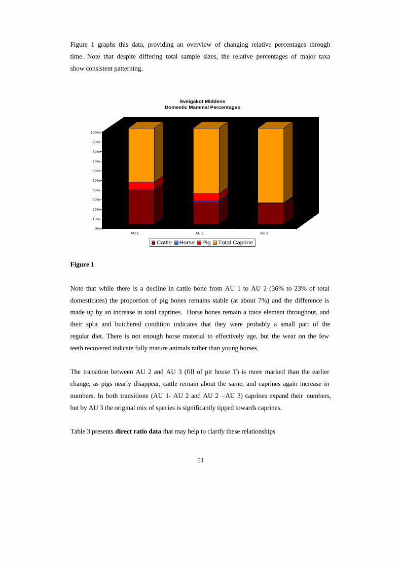
51
Figure 1 graphs this data, providing an overview of changing relative percentages through
time. Note that despite differing total sample sizes, the relative percentages of major taxa
show consistent patterning.
Figure 1
Note that while there is a decline in cattle bone from AU 1 to AU 2 (36% to 23% of total
domesticates) the proportion of pig bones remains stable (at about 7%) and the difference is
made up by an increase in total caprines. Horse bones remain a trace element throughout, and
their split and butchered condition indicates that they were probably a small part of the
regular diet. There is not enough horse material to effectively age, but the wear on the few
teeth recovered indicate fully mature animals rather than young horses.
The transition between AU 2 and AU 3 (fill of pit house T) is more marked than the earlier
change, as pigs nearly disappear, cattle remain about the same, and caprines again increase in
numbers. In both transitions (AU 1- AU 2 and AU 2 –AU 3) caprines expand their numbers,
but by AU 3 the original mix of species is significantly tipped towards caprines.
Table 3 presents direct ratio data that may help to clarify these relationships
0%
10%
20%
30%
40%
50%
60%
70%
80%
90%
100%
AU 1 AU 2 AU 3
Sveigakot Middens Domestic Mammal Percentages
Cattle Horse Pig Total Caprine
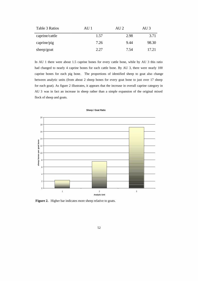
52
Table 3 Ratios AU 1 AU 2 AU 3
caprine/cattle 1.57 2.98 3.71
caprine/pig 7.26 9.44 98.30
sheep/goat 2.27 7.54 17.21
In AU 1 there were about 1.5 caprine bones for every cattle bone, while by AU 3 this ratio
had changed to nearly 4 caprine bones for each cattle bone. By AU 3, there were nearly 100
caprine bones for each pig bone. The proportions of identified sheep to goat also change
between analytic units (from about 2 sheep bones for every goat bone to just over 17 sheep
for each goat). As figure 2 illustrates, it appears that the increase in overall caprine category in
AU 3 was in fact an increase in sheep rather than a simple expansion of the original mixed
flock of sheep and goats.
Figure 2. Higher bar indicates more sheep relative to goats.
Sheep / Goat Ratio
0
2
4
6
8
10
12
14
16
18
20
1 2 3
Analytic Unit
sh
ee
p b
on
es
pe
r g
oa
t b
on
e

53
Age Reconstruction
Zooarchaeologists have traditionally used tooth eruption, tooth wear, and the fusion of the
ends of long bones to reconstruct the age of death of domestic mammals (review in Wilson,
Grigson & Payne 1982, see also Hillson 1986, Reitz and Wing 1999). Each approach is
limited by natural variability among individual animals in the pace of growth and maturation.
Nutrition, activity level, castration, parasitism, disease, and other cultural and environmental
factors influence tooth and bone growth as much or more than genetics of the breed in many
cases. Attritional loss of bone during the taphonomic changes associated with butchery,
consumption, gnawing, burning and decay do not affect all parts of the skeleton equally, and
in most cases there is strong selection against the less dense and less fully calcified bones of
younger animals (Maltby 1982, Lyman 1994). While tooth eruption schedules for most
domestic mammals vary within a fairly restricted range, tooth wear is dependent upon both
age and the abrasiveness of the food eaten. As Mainland (2000) has demonstrated fo r
Greenlandic Norse sheep, wear rates increase rapidly when more abrasive grit and soil
particles are ingested. Most workers have combined analyses of mandibular tooth eruption
and wear with examination of the fusion percentages of selected (dense) long bones
(O’Connor 1982, Bartosiewicz et al 1997, Dobney et al 1999, Maltby 1979). This study
follows the well supported and clear presentation of Enghoff’s publication (2003) on the
Greenlandic archaeofauna from the farm beneath the sand (GUS) in age assignment,
terminology, and authorities consulted.
Neonatal Elements:
AU 1AU 2
AU 3
Caprine
Pig
Cattle
0
5
10
15
20
25
30
35
40
45
50
% n
eona
tal (
NISP
)
Figure 3.
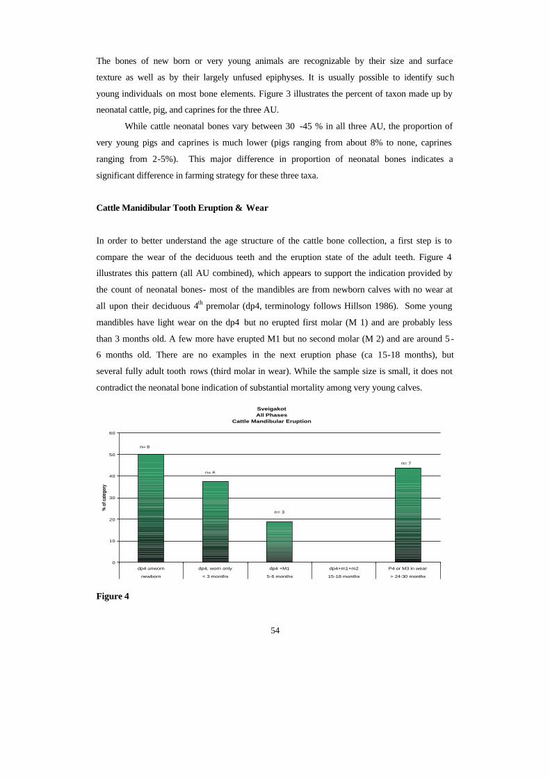
54
The bones of new born or very young animals are recognizable by their size and surface
texture as well as by their largely unfused epiphyses. It is usually possible to identify such
young individuals on most bone elements. Figure 3 illustrates the percent of taxon made up by
neonatal cattle, pig, and caprines for the three AU.
While cattle neonatal bones vary between 30 -45 % in all three AU, the proportion of
very young pigs and caprines is much lower (pigs ranging from about 8% to none, caprines
ranging from 2-5%). This major difference in proportion of neonatal bones indicates a
significant difference in farming strategy for these three taxa.
Cattle Manidibular Tooth Eruption & Wear
In order to better understand the age structure of the cattle bone collection, a first step is to
compare the wear of the deciduous teeth and the eruption state of the adult teeth. Figure 4
illustrates this pattern (all AU combined), which appears to support the indication provided by
the count of neonatal bones- most of the mandibles are from newborn calves with no wear at
all upon their deciduous 4th premolar (dp4, terminology follows Hillson 1986). Some young
mandibles have light wear on the dp4 but no erupted first molar (M 1) and are probably less
than 3 months old. A few more have erupted M1 but no second molar (M 2) and are around 5 -
6 months old. There are no examples in the next eruption phase (ca 15-18 months), but
several fully adult tooth rows (third molar in wear). While the sample size is small, it does not
contradict the neonatal bone indication of substantial mortality among very young calves.
Sveigakot All Phases
Cattle Mandibular Eruption
0
10
20
30
40
50
60
dp4 unworn dp4, worn only dp4 +M1 dp4+m1+m2 P4 or M3 in wear
newborn < 3 months 5-6 months 15-18 months > 24-30 months
% o
f cat
egor
y
n= 8
n= 6
n= 3
n= 7
Figure 4
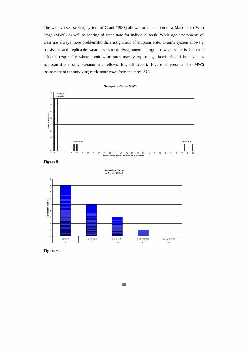
55
The widely used scoring system of Grant (1982) allows for calculation of a Mandibul ar Wear
Stage (MWS) as well as scoring of wear state for individual teeth. While age assessments of
wear are always more problematic than assignment of eruption state, Grant’s system allows a
consistent and replicable wear assessment. Assignment of age to wear state is far more
difficult (especially where tooth wear rates may vary) so age labels should be taken as
approximations only (assignment follows Enghoff 2003). Figure 5 presents the MWS
assessment of the surviving cattle tooth rows from the three AU.
Figure 5.
Sveigakot Cattle dp4 wear (total)
0
1
2
3
4
5
6
7
8
9
newborn 1-3 months 3-6 months 6-15 months 10-15 months
a b c-h j-l m>
Num
ber o
f Spe
cim
ens
Figure 6.
Sveigakot Cattle MWS
0
1
2
3
4
5
6
7
8
9
0 2 4 6 8 10 12 14 16 18 20 22 24 26 28 30 32 34 36 38 40 42 44 46 48 50
Grant MWS (adult values interpolated)
num
ber o
f spe
cim
ens
Newborn - 1 month
1- 3 months 6-8 years
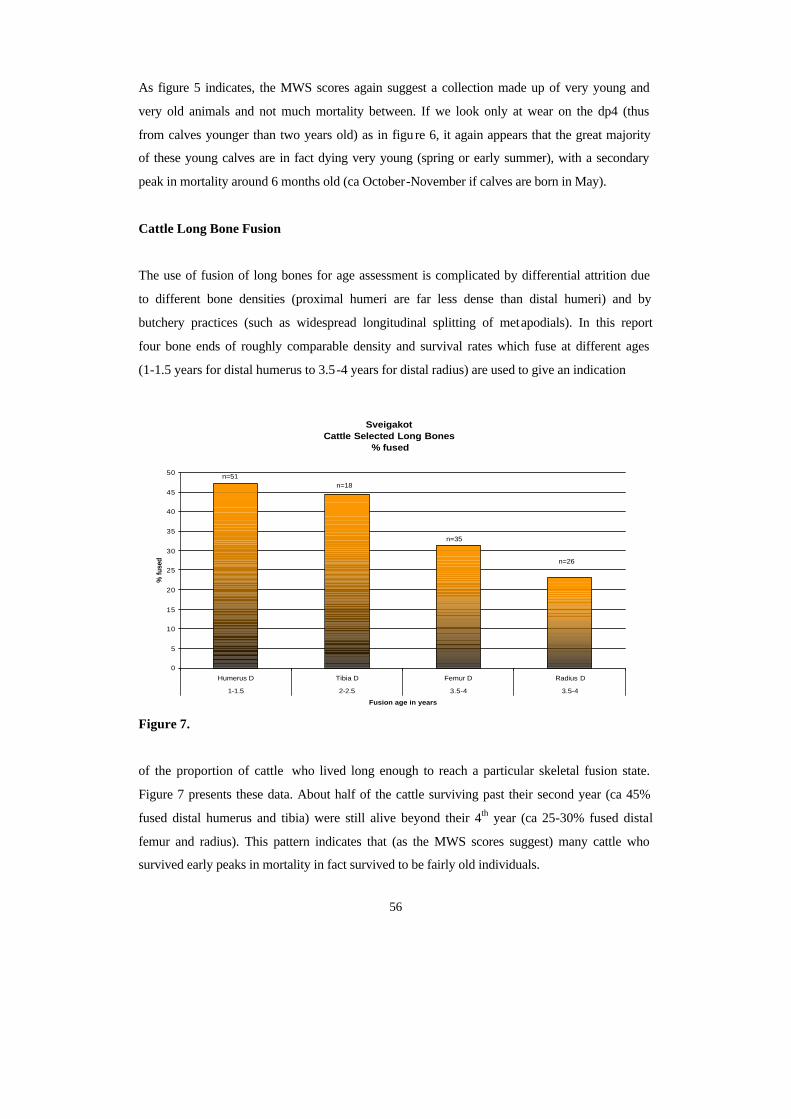
56
As figure 5 indicates, the MWS scores again suggest a collection made up of very young and
very old animals and not much mortality between. If we look only at wear on the dp4 (thus
from calves younger than two years old) as in figu re 6, it again appears that the great majority
of these young calves are in fact dying very young (spring or early summer), with a secondary
peak in mortality around 6 months old (ca October-November if calves are born in May).
Cattle Long Bone Fusion
The use of fusion of long bones for age assessment is complicated by differential attrition due
to different bone densities (proximal humeri are far less dense than distal humeri) and by
butchery practices (such as widespread longitudinal splitting of metapodials). In this report
four bone ends of roughly comparable density and survival rates which fuse at different ages
(1-1.5 years for distal humerus to 3.5-4 years for distal radius) are used to give an indication
Figure 7.
of the proportion of cattle who lived long enough to reach a particular skeletal fusion state.
Figure 7 presents these data. About half of the cattle surviving past their second year (ca 45%
fused distal humerus and tibia) were still alive beyond their 4th year (ca 25-30% fused distal
femur and radius). This pattern indicates that (as the MWS scores suggest) many cattle who
survived early peaks in mortality in fact survived to be fairly old individuals.
Sveigakot Cattle Selected Long Bones
% fused
0
5
10
15
20
25
30
35
40
45
50
Humerus D Tibia D Femur D Radius D
1-1.5 2-2.5 3.5-4 3.5-4
Fusion age in years
% fu
sed
n=51n=18
n=35
n=26
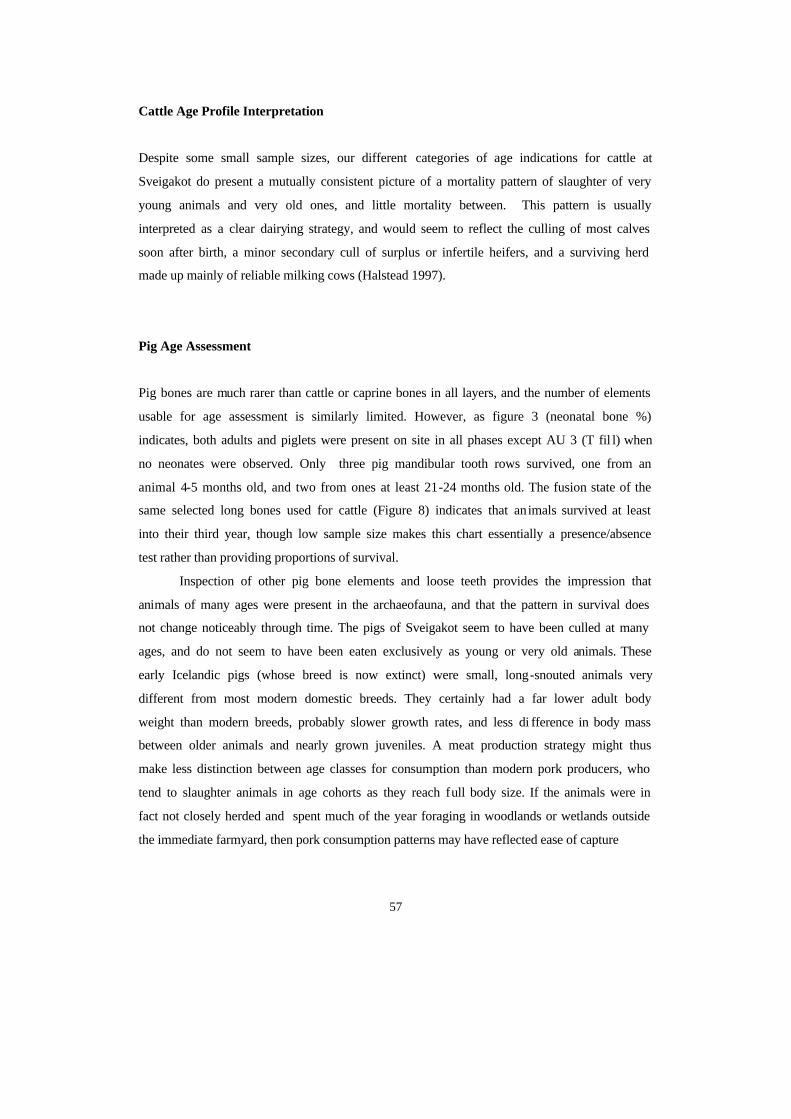
57
Cattle Age Profile Interpretation
Despite some small sample sizes, our different categories of age indications for cattle at
Sveigakot do present a mutually consistent picture of a mortality pattern of slaughter of very
young animals and very old ones, and little mortality between. This pattern is usually
interpreted as a clear dairying strategy, and would seem to reflect the culling of most calves
soon after birth, a minor secondary cull of surplus or infertile heifers, and a surviving herd
made up mainly of reliable milking cows (Halstead 1997).
Pig Age Assessment
Pig bones are much rarer than cattle or caprine bones in all layers, and the number of elements
usable for age assessment is similarly limited. However, as figure 3 (neonatal bone %)
indicates, both adults and piglets were present on site in all phases except AU 3 (T fil l) when
no neonates were observed. Only three pig mandibular tooth rows survived, one from an
animal 4-5 months old, and two from ones at least 21-24 months old. The fusion state of the
same selected long bones used for cattle (Figure 8) indicates that animals survived at least
into their third year, though low sample size makes this chart essentially a presence/absence
test rather than providing proportions of survival.
Inspection of other pig bone elements and loose teeth provides the impression that
animals of many ages were present in the archaeofauna, and that the pattern in survival does
not change noticeably through time. The pigs of Sveigakot seem to have been culled at many
ages, and do not seem to have been eaten exclusively as young or very old animals. These
early Icelandic pigs (whose breed is now extinct) were small, long-snouted animals very
different from most modern domestic breeds. They certainly had a far lower adult body
weight than modern breeds, probably slower growth rates, and less di fference in body mass
between older animals and nearly grown juveniles. A meat production strategy might thus
make less distinction between age classes for consumption than modern pork producers, who
tend to slaughter animals in age cohorts as they reach full body size. If the animals were in
fact not closely herded and spent much of the year foraging in woodlands or wetlands outside
the immediate farmyard, then pork consumption patterns may have reflected ease of capture
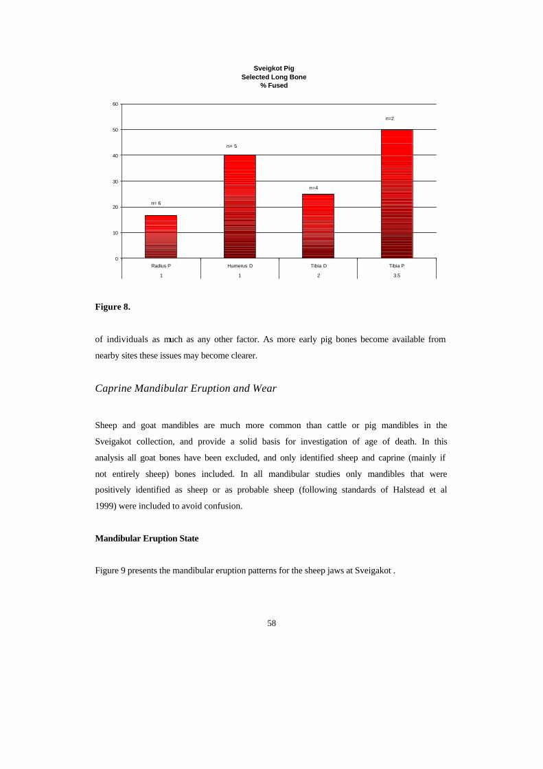
58
Figure 8.
of individuals as much as any other factor. As more early pig bones become available from
nearby sites these issues may become clearer.
Caprine Mandibular Eruption and Wear
Sheep and goat mandibles are much more common than cattle or pig mandibles in the
Sveigakot collection, and provide a solid basis for investigation of age of death. In this
analysis all goat bones have been excluded, and only identified sheep and caprine (mainly if
not entirely sheep) bones included. In all mandibular studies only mandibles that were
positively identified as sheep or as probable sheep (following standards of Halstead et al
1999) were included to avoid confusion.
Mandibular Eruption State
Figure 9 presents the mandibular eruption patterns for the sheep jaws at Sveigakot .
Sveigkot Pig Selected Long Bone
% Fused
0
10
20
30
40
50
60
Radius P Humerus D Tibia D Tibia P
1 1 2 3.5
n= 6
n= 5
n=4
n=2
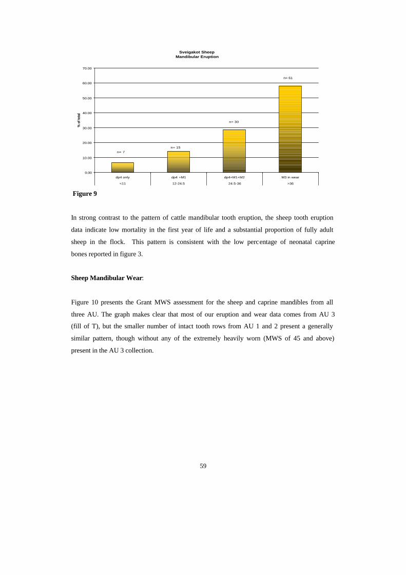
59
Figure 9
In strong contrast to the pattern of cattle mandibular tooth eruption, the sheep tooth eruption
data indicate low mortality in the first year of life and a substantial proportion of fully adult
sheep in the flock. This pattern is consistent with the low percentage of neonatal caprine
bones reported in figure 3.
Sheep Mandibular Wear:
Figure 10 presents the Grant MWS assessment for the sheep and caprine mandibles from all
three AU. The graph makes clear that most of our eruption and wear data comes from AU 3
(fill of T), but the smaller number of intact tooth rows from AU 1 and 2 present a generally
similar pattern, though without any of the extremely heavily worn (MWS of 45 and above)
present in the AU 3 collection.
Sveigakot Sheep Mandibular Eruption
0.00
10.00
20.00
30.00
40.00
50.00
60.00
70.00
dp4 only dp4 +M1 dp4+M1+M2 M3 in wear
<11 12-24.5 24.5-36 >36
% o
f tot
al
n= 7n= 15
n= 30
n= 61
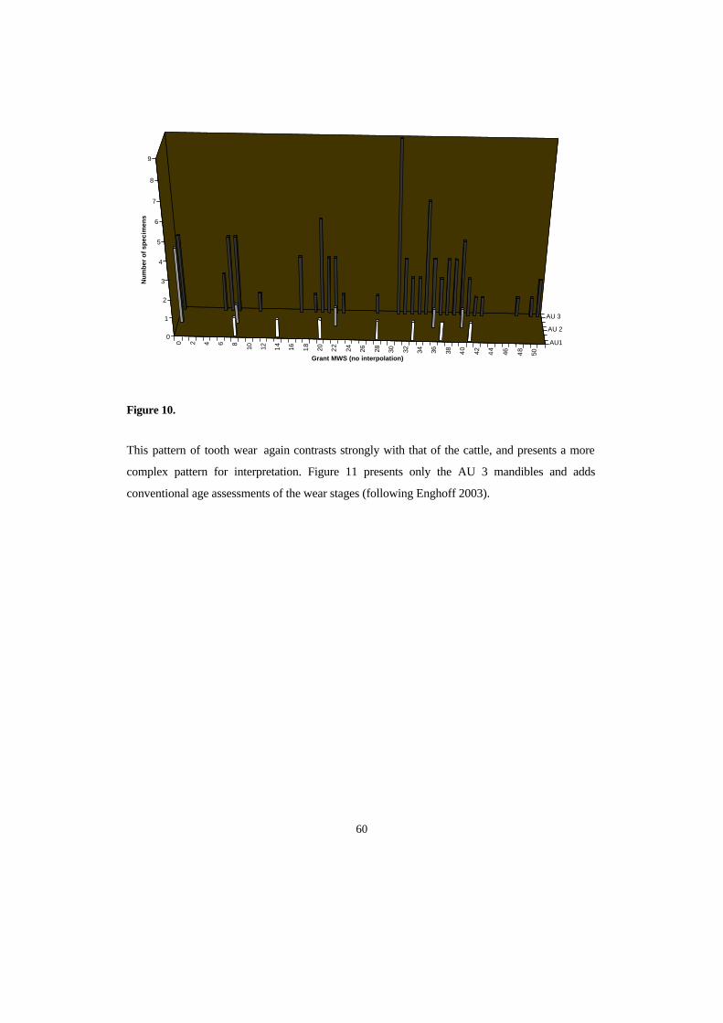
60
Figure 10.
This pattern of tooth wear again contrasts strongly with that of the cattle, and presents a more
complex pattern for interpretation. Figure 11 presents only the AU 3 mandibles and adds
conventional age assessments of the wear stages (following Enghoff 2003).
0 2 4 6 8
10 12 14
16 18
20 22
24 26 28 30 32 34 36 38 40
42 44
46 48
50
AU1
AU 2
AU 3
0
1
2
3
4
5
6
7
8
9
Nu
mb
er o
f sp
ecim
ens
Grant MWS (no interpolation)
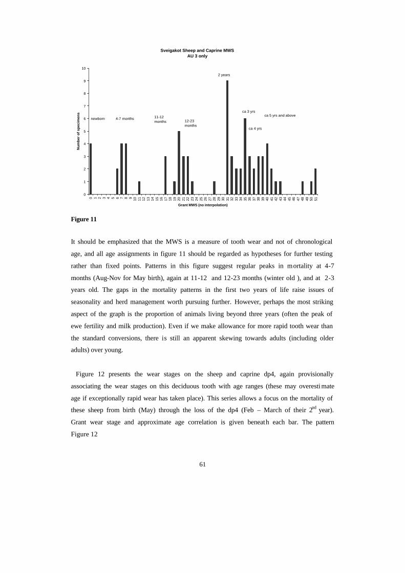
61
Sveigakot Sheep and Caprine MWSAU 3 only
0
1
2
3
4
5
6
7
8
9
10
0 1 2 3 4 5 6 7 8 9 10 11 12 13 14 15 16 17 18 19 20 21 22 23 24 25 26 27 28 29 30 31 32 33 34 35 36 37 38 39 40 41 42 43 44 45 46 47 48 49 50 51
Grant MWS (no interpolation)
Nu
mb
er o
f sp
ecim
ens
newborn 4-7 months 11-12 months 12-23
months
2 years
ca 3 yrs
ca 4 yrs
ca 5 yrs and above
Figure 11
It should be emphasized that the MWS is a measure of tooth wear and not of chronological
age, and all age assignments in figure 11 should be regarded as hypotheses for further testing
rather than fixed points. Patterns in this figure suggest regular peaks in mortality at 4-7
months (Aug-Nov for May birth), again at 11-12 and 12-23 months (winter old ), and at 2-3
years old. The gaps in the mortality patterns in the first two years of life raise issues of
seasonality and herd management worth pursuing further. However, perhaps the most striking
aspect of the graph is the proportion of animals living beyond three years (often the peak of
ewe fertility and milk production). Even if we make allowance for more rapid tooth wear than
the standard conversions, there is still an apparent skewing towards adults (including older
adults) over young.
Figure 12 presents the wear stages on the sheep and caprine dp4, again provisionally
associating the wear stages on this deciduous tooth with age ranges (these may overesti mate
age if exceptionally rapid wear has taken place). This series allows a focus on the mortality of
these sheep from birth (May) through the loss of the dp4 (Feb – March of their 2nd year).
Grant wear stage and approximate age correlation is given beneath each bar. The pattern
Figure 12
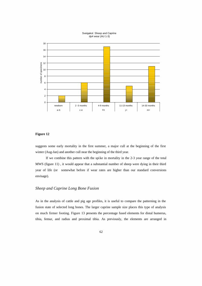
62
Figure 12
suggests some early mortality in the first summer, a major cull at the beginning of the first
winter (Aug-Jan) and another cull near the beginning of the third year.
If we combine this pattern with the spike in mortality in the 2-3 year range of the total
MWS (figure 11) , it would appear that a substantial number of sheep were dying in their third
year of life (or somewhat before if wear rates are higher than our standard conversions
envisage).
Sheep and Caprine Long Bone Fusion
As in the analysis of cattle and pig age profiles, it is useful to compare the patterning in the
fusion state of selected long bones. The larger caprine sample size places this type of analysis
on much firmer footing. Figure 13 presents the percentage fused elements for distal humerus,
tibia, femur, and radius and proximal tibia. As previously, the elements are arranged in
Sveigakot Sheep and Caprine dp4 wear (AU 1-3)
0
2
4
6
8
10
12
14
16
18
newborn 2 -3 months 4-9 months 11-13 months 14-33 months
a-b c-e f-h j-l m>
num
ber
of s
peci
men
s
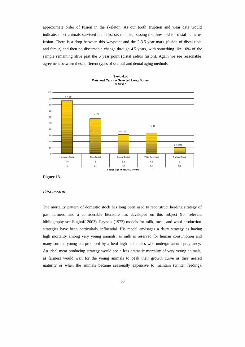
63
approximate order of fusion in the skeleton. As our tooth eruption and wear data would
indicate, most animals survived their first six months, passing the threshold for distal humerus
fusion. There is a drop between this waypoint and the 2-3.5 year mark (fusion of distal tibia
and femur) and then no discernable change through 4.5 years, with something like 10% of the
sample remaining alive past the 5 year point (distal radius fusion). Again we see reasonable
agreement between these different types of skeletal and dental aging methods.
Figure 13
Discussion
The mortality pattern of domestic stock has long been used to reconstruct herding strategy of
past farmers, and a considerable literature has developed on this subject (for relevant
bibliography see Enghoff 2003). Payne’s (1973) models for milk, meat, and wool production
strategies have been particularly influential. His model envisages a dairy strategy as having
high mortality among very young animals, as milk is reserved for human consumption and
many surplus young are produced by a herd high in females who undergo annual pregnancy.
An ideal meat producing strategy would see a less dramatic mortality of very young animals,
as farmers would wait for the young animals to peak their growth curve as they neared
maturity or when the animals became seasonally expensive to maintain (winter feeding).
Sveigakot Ovis and Caprine Selected Long Bones
% fused
0
10
20
30
40
50
60
70
80
90
100
Humerus Distal Tibia Distal Femur Distal Tibia Proximal Radius Distal
0.5 2 3.5 4.5 5
6 24 42 54 60
Fusion Age in Years & Months
n = 80
n = 106
n = 121
n = 76
n = 108
64
Adult females would be culled as they ended their reproductive peak in both cases. In a wool
producing strategy (restricted to sheep in the Icelandic case), most animals would be retained
to adulthood (except for surplus males) and might be allowed to live past their reproductive
peak as long as their health and wool production continued.
The current data from Sveigakot indicate that cattle keeping followed Payne’s dairy strategy
consistently, producing high percentages of neonatal bones and a clear pattern repeated in
both dental wear and epiphyseal fusion of many very young and some very old animals but
few between. This pattern would seem to support the longstanding assumption that cattle were
primarily managed as milk producers in the North Atlantic, confirming this position in the
economy of settlement age Iceland. The few pig remains present a less easily interpreted
pattern, but the current indication of a range of ages from young to older animals is not
inconsistent with Payne’s meat strategy, again confirming normal assumptions. The abundant
caprine data presents a more complex pattern, and may require some further consideration.
Sheep Herding Strategies: Possible Models
Several authors have discussed the possibility of “dual purpose” herding strategies combi ning
wool, meat, and milk producing patterns. Any self-sustaining farm will be compelled to
maintain a good number of fertile females to replace stock, and farmers will certainly eat any
animals they cull for any reason, so a “pure” wool producing strategy will seldom be possible.
Jón Haukur Ingimundarson (1995) argues strongly that in practice such dual purpose
strategies tend to be self defeating and that wool and dairy production in sheep are poorly
compatible. Continuously fertile, regularly lactating ewes are poor wool producers (in both
volume and quality) compared to barren ewes or castrated male wethers. He quotes both 19 th c
farming manuals and modern informants who report that wethers continue high wool
production into their 6 th-7th year while yield from fertile ewes drops drastically after their
third or fourth year (Ingimundarson 1995 :69-70). Most ewes reach their peak fertility and
milk production by this age, and in either a “classic meat” or “classic dairy” economy they
would tend to be culled at this point. Animals much older than 3-4 years are thus unlikely to
be fertile ewes, and are far more likely to be old ewes or old wethers. Old wethers (above 2
years old) are expensive animals to maintain in either a meat or dairying economy, but are
characteristic of an economy aimed at wool production. The current data from Sveigakot
65
(dominated by the AU 3 collection of the later phase farm) would thus suggest that sheep at
this farm were maintained primarily for wool production (while producing a cer tain amount
of milk and meat as byproduct).
Economic Change at Sveigakot: a speculative reconstruction
While our picture of economic change at Sveigakot is still incomplete and will always be
constrained by the limits of archaeological inference, the current domestic mammal collection
allows some well founded observations:
?? Cattle keeping was always aimed at dairy production, with meat (and skins) from
calves a minor byproduct. Cattle numbers seem to decline with time, but their function
in the economy seems fairly stable from first settlement onward.
?? Pig keeping necessarily focused on meat production, but pigs were small bodied and
probably not so carefully herded as cattle. Nevertheless their rapid rate of reproduction
and relatively low labor cost made them an attractive source of high quality meat that
could be preserved by smoking and may have been given a special social value in
feasts. Note that the major difference between the two successive AU’s in midden area
M and the later AU 3 in the fill of T is the drastic reduction in pig percentage. This
drop may reflect many factors, but it entails a significant shift in provisioning strategy
at the farm.
?? The caprine herd underwent considerable change from AU 1 onwards. Initially
balanced between sheep and goats (perhaps at as high as a 2:1 ratio) the balance
swung decisively towards sheep by AU 3, and the increased proportion of caprines in
this period is in fact an increase in sheep. Again, the reduction in goats reflects a
reduction in household provisioning of meat and milk.
?? The age profile of the sheep herd (best documented from AU 3) suggests a strategy
optimized for wool production rather than dairy production. While some meat was
certainly produced as byproduct, it seems very likely that wool production was the
main reason for keeping sheep from the beginning of the farm, and that the increase in
sheep relative to all other species in the later AU 3 period reflects a strategy aimed at
wool production at the expense of food production.
66
Many questions remain to be addressed on the economy of this important early site, including
the changing balance between household provisioning and surplus production of wool (and
possibly sheep skins). Further reports on the Sveigakot archaeofauna will examine these
questions further, and the comparative examples of nearby sites (especially Hofstaðir) will
become increasingly important as research continues in this region.
Literature
Amundsen, Colin 2002, An Archaeofauna from Miðbaer on Flatey in Breiðafjorð in NW
Iceland, Environmental Archaeology 6 , in press.
Bartosiewicz L. Wim Van Neer & A Lentacker 1997, Draught Cattle: their
osteoarchaeological identification and history . Royal Museum of Central Africa, Annals of
the Zoological Sciences vol 281 Brussels.
Bigelow G.F. 1985 Sandwick Unst and the Late Norse Shetlandic Economy, in B. Smith (ed)
Shetland Archaeology, New Work in Shetland in the 1970’s , Shetland Times Press, Lerwick,
pp 95-127.
Crabtree, P. J. 1990. Zooarchaeology and Complex Societies: some uses of faunal analysis
for the study of trade, social status and ethnicity. In Archaeological Method and Theory, Vol
2, University of Arizona Press, Tuscon
Dobney, K.M., S.D. Jaques, & B G Irving 1999 Of Butchers and Breeds, report on the
vertebrate remains from various sites in the City of Lincoln, Lincoln Archaeological Series
No 5
Driesch, A von den. 1976. A Guide to the Measurement of Animal Bones from
Archaeological Sites. Peabody Museum Bulletin 1, Peabody Museum of Archaeology and
Ethnology, Harvard University, Cambridge, Massachusetts
67
Enghoff, I. B. 2003. Hunting, fishing, and animal husbandry at the Farm Beneath the Sand,
Western Greenland: an archaeozoological analysis of a Norse farm in the Western Settlement,
Meddelelser om Grønland Man & Society 28. Copenhagen
Grant, Annie 1982. The use of tooth wear as a guide to the age of domestic ungulates, in B.
Wilson, C. Grigson, and S. Payne (eds.) Ageing and Sexing Animal Bones from
Archaeological Sites, BAR British Series 109 pp 91-108. Oxford.
Gilbert, A & Singer, B. 1982. Reassessing zooarchaeological quantification. World
Archaeology 14 (1)
Grayson, D. K. 1984. Quantitative Zooarchaeology. Academic press, Orlando
Halstead, Paul, 1998. Mortality Models and Milking: problems of uniformitarian ism,
optimality, and equifinality reconsidered, Anthropozoologica 27: 3-20.
Hillson, Simon , Teeth, 1986 Cambridge Manuals in Archaeology, Cambridge U Press.
Ingimundarson Jón Haukur 1995 Of Sagas and Sheep: toward a historical anthropology of
social change and production for market subsistence and tribute in early Iceland (10 th-13th c).
Ph D dissertation U Arizona, Univ Microfilms Anne Arbor Mich.
Lyman , R.L. 1996, Taphonomy, Cambridge U.P.
Marshall, F. & Pilgram, A. 1991. Meat versus within-bone nutrients: another look at the
meaning of body-part representation in archaeological sites. Journal of Archaeological
Science 18
Maltby. Mark. 1979 The Animal Bones from Exeter 1971-1975, Exeter Archaeological
Reports Volume 9 U Sheffield Press Sheffield
McGovern T.H., Sophia Perdikaris, Clayton Tinsley, 2001 Economy of Landnam: the
Evidence of Zooarchaeology, in Andrew Wawn & Thorunn Sigurðardottir (eds.) Approaches
to Vinland , Nordahl Inst. Studies 4, Reykjavik. Pp 154-166.
68
McGovern, T.H. & Sophia Perdikaris (2002) Preliminary Report of Animal Bones from
Hrísheimar N Iceland, report on file Fornleifastofnun lslands and National Museum of
Iceland.
McGovern, T.H. 1999. Preliminary Report of Animal Bones from Hofstadir , and Area G
excavations 1996-97, Archaeologica Islandica 1.
North Atlantic Biocultural Organization Zooarchaeology Working Group 2002. NABONE
Zooarchaeological Recording Package 7 th edition, CUNY, NY.
O’Connor T 1982 Animal Bones from Flaxengate Lincoln c 870-1500, CBA and Lincoln
Arch Trust.
Perdikaris, S. , Colin Amundsen, T. H. McGovern 2002 Report of Animal Bones from
Tjarnargata 3C, Reykjavík, Iceland, Report on file Archaeological Inst. Iceland, Reykjavik.
Perdikaris S & T.H.McGovern in press 2003, Walrus, cod fish and chieftains: patterns of
intensification in the Western North Atlantic. In T. Thurston (ed) New Perspectives on
Intensification, Plenum Press.
Perdikaris, S. 1993. Status and Economy: A Zooarchaeological Perspective from the Iron
Age Site of Aker, Norway. Masters Thesis Hunter College
Tinsley, Clayton M. 2002a The Viking settlement of northern Iceland: a zooarchaeological
perspective, Environmental Archaeology 6, Oxbow, (in press).
Tinsley, Clayton M, 2002b The zooarchaeology of settlement: some quantitative questions,
Proceedings of the 21st Nordic Archaeology Conference Akureyri Iceland (in press).
69
Tinsley, C.M. & T.H. McGovern 2001. Zooarchaeology of Aðalstræti 14-16, 2001 Report of
the Viking Period Animal Bones. Report on file Fornleifastofnun lslands (FSl) and National
Museum of Iceland.
Vésteinsson, Orri, 2001, Archaeological investigations at Sveigakot 1998-2000, Reykjavik,
FSl.
Wilson, B, C Grigson & S Payne (eds) 1982 Ageing and Sexing Animal Bones from
Archaeological Sites, BAR British Series 109 Oxford.
Aknowledgements:
This paper is the product of generous support from the Leverhulme Trust, National
Geographic Society, US National Science Foundation (Archaeology and Arctic Social
Science Programs), the PSC-CUNY grants program, the Icelandic Research Council, and the
Institute of Archaeology, Iceland. The assistance of Colin Amundsen in sorting many of these
bones and the sound advice of many colleages in the NABO research cooperative is gratefully
acknowledged. This is a product of the NABO research cooperative and of the Leverhulme
Landscapes Circum Landnám project.
70
Orri Vésteinsson
Samantekt
Sumarið 2002 var grafið 22. júlí til 16. ágúst á tveimur svæðum á Sveigakoti:
Á svæði S var lokið uppgrefti á eldri skálabyggingu og viðbyggingum að öðru leyti en
því að neðsta gólflög voru ekki tekin upp og býður það næsta árs. Skálinn er rúmlega 20 m
langur og um 5 m breiður með bogadregnum langveggjum. Hann er yngri en gjóskulagið
V~950, frá því á seinni hluta 10. aldar eða byrjun þeirrar 11. Dyr eru á suðurlangvegg – sem
að öllu leyti hefur verið úr torfi – og hefur þar verið gengið inn í íbúðarrýmið. Í því hefur
verið langeldur á miðju gólfi og set til beggja hliða. Vesturgafl hússins er skemmdur og
sömuleiðis var austurgaflinn illa farinn. Í ljós kom að viðbyggingarnar til austurs (3) og
norðurs (5) tilheyra ekki þessu elsta byggingarstigi eins og upphaflega var talið heldur yngra
stiginu, mjóa skálanum sem grafinn var upp 2000-2001. Flórinn í eystri viðbyggingunni
bendir til að hún hafi verið fjós, en hann hefur verið settur ofan á gólflag í eldra húsi (6) sem
eftir á að grafa fram. Í gegnum norðurlangvegg yngri skálans voru dyr inn í litla viðbyggingu
(5). Í henni var sáfar sem bendir til að hún hafi upphaflega verið notuð sem búr en síðar voru
byggð í henni eldstæði sem benda til að húsinu hafi verið breytt í eldhús. Þessi viðbygging
hefur síðan lagst af meðan skálinn var enn í notkun því efst í henni var öskuhaugur.
Ýmsir gripir fundust, mest úr málmi, steini og beini, og koma þeir allir heim og saman
við túlkun hússins sem íbúðarhúss. Nær allir gripirnir voru í vesturenda hússins, en fáir í
búri/eldhúsi eða fjósi.
Á svæði T var lokið við uppgröft á litlu jarðhúsi og öðru eldra og stærra sem lá undan
því til suðurs. Eldra húsið var aflangt, rúmlega 6 m á lengd en aðeins 2 m á breidd. Það sást
aðeins sem óreglulegur niðurgröftur en tveir inngangar voru greinilegir, annar sunnarlega á
austurlanghlið og hinn norðantil á vesturlanghlið. Í botni byggingarinnar voru tvær grunnar
en breiðar gryfjur fullar af lífrænum leifum og nokkrar litlar holur hringinn í kr ingum báðar
en að öðru leyti var lítið um gólfskán eða önnur ummerki. Sennilega er um að ræða óvandaða
byggingu sem notuð hefur verið til að vinna og/eða geyma matvæli.
Engar sambærilegar byggingaleifar hafa áður fundist á Íslandi, enda voru þessi
ummerki mjög lítilfjörleg og þess eðlis að eldri uppgraftaraðferðir myndu ekki hafa leitt þau í
ljós. Meðal gripa sem komu í ljós í þessari byggingu, eru tveir bútar af bátasaum, og kemur
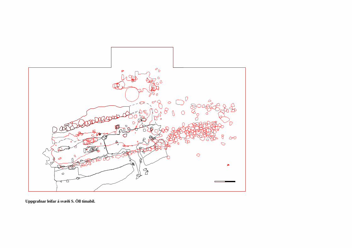
Uppgrafnar leifar á svæði S. Öll tímabil.
það nokkuð á óvart í ljósi staðsetningar Sveigakots. Þessi fundur gæti rennt stoðum undir þá
tilgátu að Framengjar hafi að hluta verið stöðuvatn á fyrstu öldum Íslandsbyggðar sem síðar
fylltist af framburði Krákár.
Svæði það sem byggingaleifar er að finna á milli S og T var afmarkað enn frekar og er
ljóst að byggingaleifar er fyrst og fremst að finna fast sunnan við S á svæði sem er um 15 m á
lengd frá austri til vesturs og 7 m á breidd frá norðri til suðurs, og fast norðan við T á svæði
sem er um 7x7 m að stærð.
Urbanczyk og aðstoðarmenn hans unnu að því sumarið 2002 að þróa nýja aðferð við
skráningu uppgraftargagna með styrk frá Sony í Póllandi sem lagði til vélbúnað (stafræna
myndavél og fartölvu). Byggður var turn úr stillansaefni og stafrænar myndir teknar af hverri
einustu uppgraftareiningu jafnóðum og þær voru grafnar fram. Stafræna myndin var síðan
hnitsett jafnóðum og þannig gerð teikning af einingunni á stafrænu formi. Með þessari aðferð
er komist hjá því að teikna nokkuð í höndunum og gögnin sem fást eru mun nákvæmari auk
þess sem aðferðin reyndist mun fljótlegri heldur en sú hefðbundna eftir að reynsla var komin
á hana.
Með áframhaldandi uppgrefti hefur fengist skýrari mynd af byggingaleifum á
Sveigakoti þó enn séu ýmis kurl ekki komin til grafar. Uppgrefti á svæði T er lokið og ekki
meir en 2-3 daga vinna eftir á svæði S. Sumarið 2003 verður því fyrst og fremst unnið að
rannsókn byggingaleifa á svæði N – sem er næst fyrir sunnan S og svæði L sem er næst fyrir
norðan T.
Ennþá hafa ekki komið í ljós byggingaleifar sem með vissu er hægt að tengja elsta
ábúðarskeiði Sveigakots, þ.e. á 9. og 10. öld, en þá var blómatími bæjarins ef marka má
dýrabeinagreiningar. Byggingaleifar þær sem grafnar hafa verið fram eru frá seinni hluta 10.
aldar, 11. og 12. öld og er ekki loku fyrir það skotið að búið hafi verið í Sveigakoti fram á 13.
öld. Á 11. öld. var eldri skálinn á svæði S yfirgefinn en tóftin síðar notuð sem skýli,
hugsanlega sem sel. Seinna á 11. öld eða svo var svo aftur gerð tilraun með búskap á
Sveigakoti og var þá yngsti skálinn byggður á rústum hins eldra og skeytt við hana
viðbyggingum til austurs og norðurs.
Þær byggingar sem grafnar hafa verið fram á Sveigakoti eru sumar nokkuð
frábrugðnar öðrum byggingaleifum sem grafnar hafa verið upp frá sama tímabili. Eldri
skálinn á svæði S er mjög dæmigerður fyrir íslensk víkingaaldarhús en sá yngri er aftur á móti
af gerð sem ekki hefur sést víða, þó benda megi á skyldar byggingar, t.d. í Herjólfsdal og á
Snjáleifartóttum í Þjórsárdal. Þessi gerð, sem einkennist af beinum grjóthlöðnum veggjum og
73
mun mjórri rýmum (<3 m) en tíðkuðust í víkingaaldrarhúsum, hefur þróast um allt land á 11.
og 12. öld og má líta á hana sem “týnda hlekkinn” milli eldaskála víkingaaldar og íslenska
torfbæjarins.
Yngra jarðhúsið á svæði T er líka einstakt, bæði hvað varðar stærð, og þá staðreynd að
í því eru bekkir og greinilegur inngangur. Ómögulegt er að húsið hafi getað verið vefstofa
eins og oft er haldið fram um jarðhús – í því er einflaldlega ekkert pláss fyrri vefstað – og er
greinilega um íveruhús af einhverju tagi að ræða. Eldra jarðhúsið er alveg einstakt meðal
íslenskra byggingaleifa og mun greining lífrænu leifanna sem í því fundust vonandi varpa
ljósi á hlutverk þess.
Allt bendir til að búskapur hafi staðið með blóma á Sveigakoti á 9. og 10. öld en um
1000 fer að halla undir fæti og virðist búskapur þar hafa lagst alveg af um skeið.. Ekki er
hægt að rekja hnignun Sveigakots beint til umhverfisþátta, a.m.k. ekki stórfellds uppblásturs
því hann hófst ekki á þessu svæði fyrr en eftir 1500. Settar hafa verið fram tilgátur um að
hnignun Sveigakots eigi sér félagslegar og pólitískar orsakir og tengist valdasamþjöppun í
Mývatnssveit á 11. öld – önnur hlið á sama peningi og Hofstaðir eru dæmi um.
Ýmsar aðferðafræðielgar nýjungar hafa verið reyndar á Sveigakoti, einkum hvað
varðar greiningu á gólfum. Fyrir utan örformgerðargreiningu sem nú hefur verið reynd með
góðum árangri í nokkur ár í fornleifarannsóknum við Mývatn, hefur Karen Milek gert
efnagreiningar á gólfefni frá Sveigakoti. Þær niðurstöður sem þegar liggja fyrir benda til að
hægt sé að nota þessar aðferðir til að greina hvar skilrúm og veggir voru og til að skilgreina
mismunandi vinnusvæði. Þessar rannsóknir eru hluti af doktorsverkefni Karenar við
Cambridge háskóla sem hún mun leggja fram til varnar um mitt ár 2003.
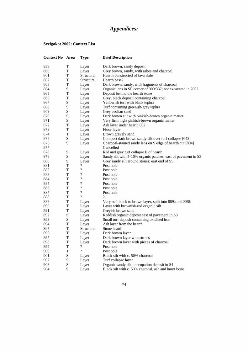
74
Appendices:
Sveigakot 2002: Context List Context No Area Type Brief Description
859 T Layer Dark brown, sandy deposit 860 T Layer Grey brown, sandy, with ashes and charcoal 861 T Structural Hearth constructed of lava slabs 862 T Structural Hearth base? 863 T Layer Dark brown, sandy, with fragments of charcoal 864 S Layer Organic lens in SE corner of 900/337; not excavated in 2002 865 T Layer Deposit behind the hearth stone 866 T Layer Grey, black deposit containing charcoal 867 S Layer Yellowish turf with black tephra 868 S Layer Turf containing greenish-grey tephra 869 S Layer Grey aeolian sand 870 S Layer Dark brown silt with pinkish-brown organic matter 871 S Layer Very firm, light pinkish-brown organic matter 872 T Layer Ash layer under hearth 862 873 T Layer Floor layer 874 T Layer Brown gravely sand 875 S Layer Compact dark brown sandy silt over turf collapse [643] 876 S Layer Charcoal-stained sandy lens on S edge of hearth cut [804] 877 Cancelled 878 S Layer Red and grey turf collapse E of hearth 879 S Layer Sandy silt with 5-10% organic patches, east of pavement in S3 880 S Layer Grey sandy silt around stones; east end of S5 881 T ? Post hole 882 T ? Post hole 883 T ? Post hole 884 T ? Post hole 885 T ? Post hole 886 T ? Post hole 887 T ? Post hole 888 T ? ? 889 T Layer Very soft black to brown layer, split into 889a and 889b 890 T Layer Layer with brownish-red organic silt 891 T Layer Greyish brown sand 892 S Layer Reddish organic deposit east of pavement in S3 893 S Layer Small turf deposit containing oxidised iron 894 T Layer Ash layer from the hearth 895 T Structural Stone hearth 896 T Layer Dark brown layer 897 T Layer Dark brown layer with stones 898 T Layer Dark brown layer with pieces of charcoal 899 T ? Post hole 900 T ? Post hole 901 S Layer Black silt with c. 50% charcoal 902 S Layer Turf collapse layer 903 S Layer Organic sandy silt; occupation deposit in S4 904 S Layer Black silt with c. 50% charcoal, ash and burnt bone
75
905 S Layer Lump of turf north of pavement in S3 906 S Layer Lump of turf north of pavement in S3 907 T Layer Organic layer 908 T Layer Organic layer 909 S Layer Small, black, ashy deposit; possibly charred turf 910 S Layer Lump of turf north of pavement in S3 911 S Layer Windblown sand in S5 912 S Layer Turf layer above the floor in S4 913 S Layer Small turf layer north of pavement in S3 914 S Layer Small turf layer west of pavement in S3 915 T ? Post hole 916 T ? Post hole 917 T ? Post hole 918 T ? Post hole 919 T ? Post hole 920 T ? Post hole 921 T ? Post hole 922 T ? Post hole 923 T ? Post hole 924 T ? Post hole 925 T ? Post hole 926 T ? Post hole 927 T ? Post hole 928 T ? Post hole 929 S Layer Small deposit of organic black/grey silt on top of S5 floor 930 S Cut Shallow post setting containing stones in S4 931 T Layer Dark brown sandy layer 932 S Layer Mixed turf and soil on top of floor 561 933 T ? Post hole 934 T ? Post hole 935 T ? Post hole 936 S Layer Reddish sandy silt 937 S Fill Homogenous brown fill of post hole [945] in S5 938 S Layer Black charcoal dump on W end of S1/4 939 S Layer Orangy turf layer west of pavement [624] 940 S Fill Packing around the stones of hearth [796] 941 S Layer Small turf layer west of pavement in S3 942 S Layer Mixed organic turf and soil on the south edge of floor [561] in S4 943 Cancelled 944 Cancelled 945 S Cut Rectangular cut for post hole on the W edge of S5 946 S Layer Thick abandonment/collapse layer over floor [561] in S4 947 S Layer Small layer of turf collapse 948 Cancelled 949 Cancelled 950 S Fill Mixed ash and sand filling the top of cooking pit [954] 951 S Fill Ashy fill at the bottom of cooking pit [954] 952 S Layer Small lump of turf on the S bench of S4 953 S Layer Small lump of turf on the S bench of S4 954 S Cut Oval-shaped cut for cooking pit in SE S5 955 S Layer Small deposit of turf collapse in the S doorway of S4 956 S Structural Stone lining of cooking pit [954] 957 S Fill Packing around the stones lining cooking pit [954] 958 S Fill Mixed sandy silt and tephra, possibly upcast from cut [954] in S5 959 S Layer Very mixed turf with organic matter in S doorway of S4
76
960 S Layer Mixed soil and organic matter on top of the S bench of S4 961 S Layer Mixed organic turf and ash in the W end of S4 962 S Layer Small deposit of turf on top of floor [561] in S4 963 S Cut Narrow oval cut in S5 containing fill [958] 964 S Layer Small deposit of turf; lumped with [936] 965 S Fill Fill of narrow rectangular cut [968] on W end of S4 966 S Fill Fill of post hole [967], at the E end of the rectangular cut [965] 967 S Cut Cut of small post hole in S4, filled with [966] 968 S Cut Narrow rectangular cut of unknown function, filled with [965] 969 S Fill Very mixed fill of large post hole [975] in S bench of S4 970 S Fill Fill of possible beam slot [971] 971 S Cut Cut of possible beam slot in S4, filled with [970] 972 Cancelled 973 S Fill Fill of post hole [977] in S5 974 S Fill Fill of small post hole/stake hole [976] in S5 975 S Cut Post hole in the S bench of S4, filled with [969] 976 S Cut Cut of small post hole/stake hole in S5, filled with [974] 977 S Cut Cut of post hole in S5, filled with [973] 978 S Cut Cut of post hole in S5, filled with [979] 979 S Fill Fill of post hole [978] in S5 980 S Fill Fill of post hole [981] in S5 981 S Cut Cut of post hole in S5, filled with [980] 982 S Layer Mixed organic soil layer in SE corner of S4 983 S Layer Small deposit of mixed/disturbed turf in N part of S4 984 S Layer Small deposit of sandy turf in a depression in the SE corner of S4 985 S Fill Fill of post hole [992] in S3 986 S Layer Small occupation deposit in S5 987 S Layer Small organic deposit in the north of S1/4 988 S Layer Layer of mixed upcast; later resolved into a series of post holes in
S5 989 S Layer Sandy occupation deposit in the S doorway of S4 990 S Layer Small deposit of mixed turf on the N bench of S4 991 S Layer Small deposit of mixed turf on the N bench of S4 992 S Cut Cut of post hole in S3, filled with [985] 993 S Cut Cut of post hole in S5, filled with [994] 994 S Fill Fill of post hole [993] in S5 995 S Fill Fill of small depression/ post impression [998] in S3 996 S Fill Fill of post hole [997] in S5 997 S Cut Cut of post hole in S5, filled with [996] 998 S Cut Cut/depression in S3 filled with [995] 999 S Fill Fill of post hole [1003] in S4 1000 S Cut Cut of post hole in S5, filled with [1001] 1001 S Fill Fill of post hole [1000] in S5 1002 S Layer Small sandy deposit in S3 1003 S Cut Cut for post hole in S4, filled with [999] 1004 S Fill Fill of post pipe [1011] in S4 1005 S Structural Square stone setting in S doorway of S4 1006 S Layer Small, thin deposit up against the N bench of S4 1007 S Cut Cut for hearth [1009] on W side of S5 1008 S Layer Small charcoal-stained layer in depression in SE corner of S4 1009 S Structural Flat lava stone base of a hearth on W side of S5 1010 S Fill Fill of post hole [1012] in S4 1011 S Cut Cut of post pipe in post hole [1003] in S4, filled with [1004] 1012 S Cut Cut of post hole in S4, filled with [1010] 1013 S Fill Fill of post hole [1014] in S5
77
1014 S Cut Cut of post hole in S5, filled with [1013] 1015 S Structural Southern turf wall of S4 1016 S Fill Fill of post hole [1017] in S5 1017 S Cut Cut of post hole in S5, filled with [1016] 1018 S Fill Fill of post hole 1019 in S5 1019 S Cut Cut of post hole in S5, filled with [1018] 1020 Cancelled 1021 S Layer Ashy fill of hearth [1022] in S6; only partially excavated in 2003 1022 S Structural Flat lava stone base of a hearth on S side of S6; not excavated 1023 S Fill Fills of stake holes in S5; not excavated in 2003 1024 S Fill Fill of post hole [1025] in S5 1025 S Cut Post hole in S5, filled with [1024] Sveigakot 2002: Finds List Object No Area Context Material Description
1 T 800 Stone Spindle whorl; red sandstone 2 T 800 Bone Worked whale bone; possible fragment of a smoothing
board 3 S 686 Iron Unidentifiable iron object 4 S 686 Iron slag 38 pieces of slag 5 S 686 Stone Fire cracked rock; basalt 6 T 782 Iron Fragments of a broken nail 7 S 686 Iron Unidentifiable iron object 8 T 863 Iron Nail head 9 T 866 Iron Knife 10 T 866 Iron Possible nail 11 T 890 Iron Nail 12 S 549 Iron Nail 13 S 549 Iron Possible nail fragment 14 S 549 Stone Fire cracked stone 15 T 894 Iron Boat nail 16 T 894 Iron Boat nail 17 S 903 Iron Unidentifiable iron object 18 T 744 Iron Nail fragments 19 T 744 Iron Hook 20 T 896 Iron Nail head 21 T 896 Stone Flint 22 S 797 Iron Nail 23 S 940 Stone Worked stone; red sandstone 24 S 940 Stone Calcite pebble 25 S 854 Stone Calcite pebble; appears to be worked 26 S 854 Iron Possible nail (no location) 27 S 854 Iron Possible nail; x901.5/y347.5 (no elevation) 28 S 946 Iron slag Slag 29 S 946 Iron Rivet 30 S 946 Iron Nail 31 S 946 Stone Spindle whorl; red sandstone 32 S 561 Copper Flat copper object; x898.12/y341.6/z284.77 33 S 561 Copper Small loop; x892/y339.8/z284.51 34 S 964 Iron Nail 35 S 561 Iron Flat iron object; x895.45/y340.5/z284.55 36 S 561 Iron Nail; x892.46/y340.65/z284.55
78
37 S 561 Stone Steatite fragment; x892.76/y340.75/z284.555 38 S 985 Iron slag Slag 39 S 989 Iron slag 1 large piece of slag; x990.9/y338.9/z284.94 40 S 989 Iron Nail; x991.11/y338.7/z284.94 41 S 989 Iron slag 1 small piece of slag; x990.94/y338.8/z284.93 42 S 989 Iron Iron object (from sieve); x990.9/y339 43 S 561 Stone Whetstone; x896.7/y342.1/z284.64 44 S 561 Iron Unidentified iron object (no location) 45 S 1021 Iron slag 1 small piece of slag 46 S 989 Stone Assorted basalt and lava pebbles deposited just within
south entrance of Structure 5 47 S 982 Stone Assorted basalt and lava pebbles deposited just w ithin
south entrance of Structure 5 48 S n/a Stone Spindle whorl fragment (half); red sandstone; found while
cleaning; not possible to attribute to a context, but should be attributed to the phase of midden dumping in Structure 5
49 S 561 Stone Flint flake; x902.35/y343/z284.98 Sveigakot 2002: Sample List Sample Area Context Grid Quantity Sample Type X Y
1 S 686 905/337 1 bag Wood 2 T 782 1 bucket (20 L) Flotation; ash from hearth 3 S 686 900/337 1 bag Wood 4 S 686 900/337 1 bag Wood 5 S 686 900/337 1 bag Wood 6 S 686 900/337 1 bag Wood 7 S 686 900/337 1 bag Wood 8 S 686 900/337 1 bag Wood 9 S 686 900/337 1 bag Wood 10 S 686 900/337 1 bag Charcoal 11 S 686 900/337 1 bag Wood 12 S 686 900/337 1 bag Wood 13 S 686 900/337 1 bag Wood 14 S 686 900/337 1 bag Wood 15 S 686 900/337 1 bag Wood 16 S 686 900/337 1 bag Wood 17 S 633 900/337 1 bag Wood 18 S 633 900/337 1 bag Wood 19 T 872 893/306 1 bucket (20 L) Flotation; ash from hearth 20 S 875 890-895/337 1 bag Charcoal 21 T 884 894/305 1 bag Charcoal and wood 22 T 881 893/307 1 bag Charcoal 23 S 878 900/337 1 bag Wood 24 S 878 900/337 1 bag Charcoal 25 S 879 905/343 1 bag Soil chemistry 26 S 892 905/343 1 bag Soil chemistry 27 S 880 900/349 1 bag Charcoal 28 S 901 900/349 1 bag Charcoal 29 T 894 893-895/305 1 bucket (20 L) Flotation; ash and
charcoal
30 S 903 900/337 1 bag Soil chemistry 901 343 31 S 903 900/337 1 bag Soil chemistry 901.5 343
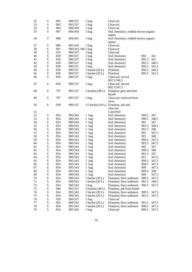
79
32 S 903 900/337 1 bag Charcoal 33 S 902 895/337 1 bag Charcoal 34 S 904 898/349 1 bag Charcoal 35 T 907 894/304 1 bag Soil chemistry; reddish brown organic
matter 36 T 908 894/301 1 bag Soil chemistry; reddish brown organic
matter 37 S 906 905/343 1 bag Charcoal 38 S 901 900/343-349 1 bag Charcoal 39 S 914 900/337 1 bag Charcoal 40 S 839 890/337 1 bag Soil chemistry 892 341 41 S 839 890/337 1 bag Soil chemistry 892.5 341 42 S 839 890/337 1 bag Soil chemistry 892.5 340.5 43 S 839 890/337 1 bag Soil chemistry 892.5 341.5 44 S 839 890/337 1 bucket (20 L) Flotation 892.5 340.5 45 S 839 890/337 1 bucket (20 L) Flotation 892.5 341.5 46 S 839 890/337 1 bag Charcoal; sieved
892.5/340.5
47 S 839 890/337 1 bag Charcoal; sieved 892.5/341.5
48 S 797 895/337 2 buckets (40 L) Flotation; grey ash from hearth
49 S 797 895/337 1 bag Charcoal; retrieved from sieve
50 S 938 890/337 1/2 bucket (10 L) Flotation; ash and charcoal
51 Cancelled 52 S 854 900/343 1 bag Soil chemistry 900.5 347 53 S 854 900/343 1 bag Soil chemistry 900.5 348.5 54 S 854 900/343 1 bag Soil chemistry 901 347 55 S 854 900/343 1 bag Soil chemistry 901.5 348.5 56 S 854 900/343 1 bag Soil chemistry 901.5 348 57 S 854 900/343 1 bag Soil chemistry 902 347.5 58 S 854 900/343 1 bag Soil chemistry 901 348 59 S 854 900/343 1 bag Soil chemistry 900.5 347.5 60 S 854 900/343 1 bag Soil chemistry 901.5 347.5 61 S 854 900/343 1 bag Soil chemistry 902 347 62 S 854 900/343 1 bag Soil chemistry 900.5 348 63 S 854 900/343 1 bag Soil chemistry 901.5 347 64 S 854 900/343 1 bag Soil chemistry 901 347.5 65 S 854 895/343 1 bag Soil chemistry 899.5 347.5 66 S 854 895/343 1 bag Soil chemistry 898.5 347.5 67 S 854 895/343 1 bag Soil chemistry 899 347.5 68 S 854 895/343 1 bag Soil chemistry 899.5 348 69 S 854 900/343 1 bag Soil chemistry 900 347.5 70 S 854 900/343 1 bucket (20 L) Flotation; floor sediment 900.5 347.5 71 S 854 900/343 1 bucket (20 L) Flotation; floor sediment 901.5 348.5 72 S 854 900/343 1 bag Flotation; floor sediment 900.5 347.5 73 S 940 895/337 2 buckets (40 L) Flotation; ash from hearth 74 S 854 895/343 1 bucket (20 L) Flotation; floor sediment 899.5 347.5 75 S 854 900/343 1 bucket (20 L) Flotation; floor sediment 901.5 347.5 76 S 939 900/337 1 bag Charcoal 77 S 854 900/343 1 bucket (20 L) Flotation; floor sediment 901.5 347.5 78 S 854 895/343 1 bucket (20 L) Flotation; floor sediment 898.5 347.5 79 S 854 895/343 1 bag Charcoal 899.5 347.5
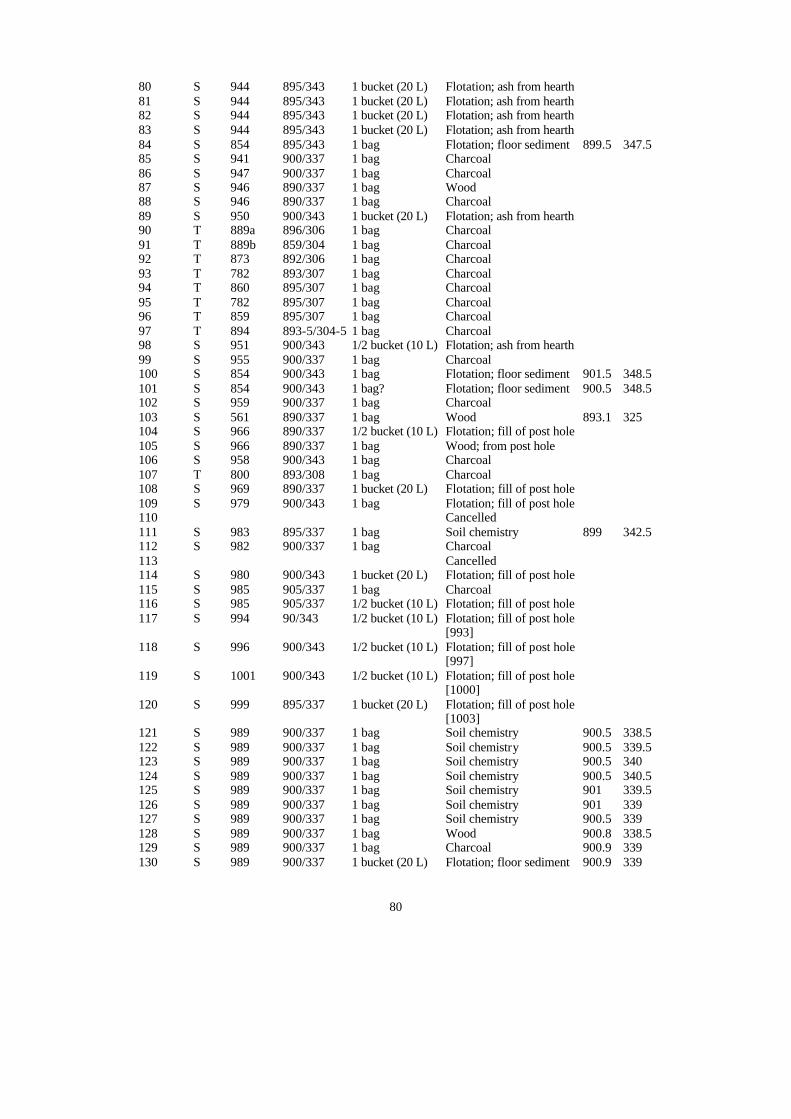
80
80 S 944 895/343 1 bucket (20 L) Flotation; ash from hearth 81 S 944 895/343 1 bucket (20 L) Flotation; ash from hearth 82 S 944 895/343 1 bucket (20 L) Flotation; ash from hearth 83 S 944 895/343 1 bucket (20 L) Flotation; ash from hearth 84 S 854 895/343 1 bag Flotation; floor sediment 899.5 347.5 85 S 941 900/337 1 bag Charcoal 86 S 947 900/337 1 bag Charcoal 87 S 946 890/337 1 bag Wood 88 S 946 890/337 1 bag Charcoal 89 S 950 900/343 1 bucket (20 L) Flotation; ash from hearth 90 T 889a 896/306 1 bag Charcoal 91 T 889b 859/304 1 bag Charcoal 92 T 873 892/306 1 bag Charcoal 93 T 782 893/307 1 bag Charcoal 94 T 860 895/307 1 bag Charcoal 95 T 782 895/307 1 bag Charcoal 96 T 859 895/307 1 bag Charcoal 97 T 894 893-5/304-5 1 bag Charcoal 98 S 951 900/343 1/2 bucket (10 L) Flotation; ash from hearth 99 S 955 900/337 1 bag Charcoal 100 S 854 900/343 1 bag Flotation; floor sediment 901.5 348.5 101 S 854 900/343 1 bag? Flotation; floor sediment 900.5 348.5 102 S 959 900/337 1 bag Charcoal 103 S 561 890/337 1 bag Wood 893.1 325 104 S 966 890/337 1/2 bucket (10 L) Flotation; fill of post hole 105 S 966 890/337 1 bag Wood; from post hole 106 S 958 900/343 1 bag Charcoal 107 T 800 893/308 1 bag Charcoal 108 S 969 890/337 1 bucket (20 L) Flotation; fill of post hole 109 S 979 900/343 1 bag Flotation; fill of post hole 110 Cancelled 111 S 983 895/337 1 bag Soil chemistry 899 342.5 112 S 982 900/337 1 bag Charcoal 113 Cancelled 114 S 980 900/343 1 bucket (20 L) Flotation; fill of post hole 115 S 985 905/337 1 bag Charcoal 116 S 985 905/337 1/2 bucket (10 L) Flotation; fill of post hole 117 S 994 90/343 1/2 bucket (10 L) Flotation; fill of post hole
[993]
118 S 996 900/343 1/2 bucket (10 L) Flotation; fill of post hole [997]
119 S 1001 900/343 1/2 bucket (10 L) Flotation; fill of post hole [1000]
120 S 999 895/337 1 bucket (20 L) Flotation; fill of post hole [1003]
121 S 989 900/337 1 bag Soil chemistry 900.5 338.5 122 S 989 900/337 1 bag Soil chemistry 900.5 339.5 123 S 989 900/337 1 bag Soil chemistry 900.5 340 124 S 989 900/337 1 bag Soil chemistry 900.5 340.5 125 S 989 900/337 1 bag Soil chemistry 901 339.5 126 S 989 900/337 1 bag Soil chemistry 901 339 127 S 989 900/337 1 bag Soil chemistry 900.5 339 128 S 989 900/337 1 bag Wood 900.8 338.5 129 S 989 900/337 1 bag Charcoal 900.9 339 130 S 989 900/337 1 bucket (20 L) Flotation; floor sediment 900.9 339
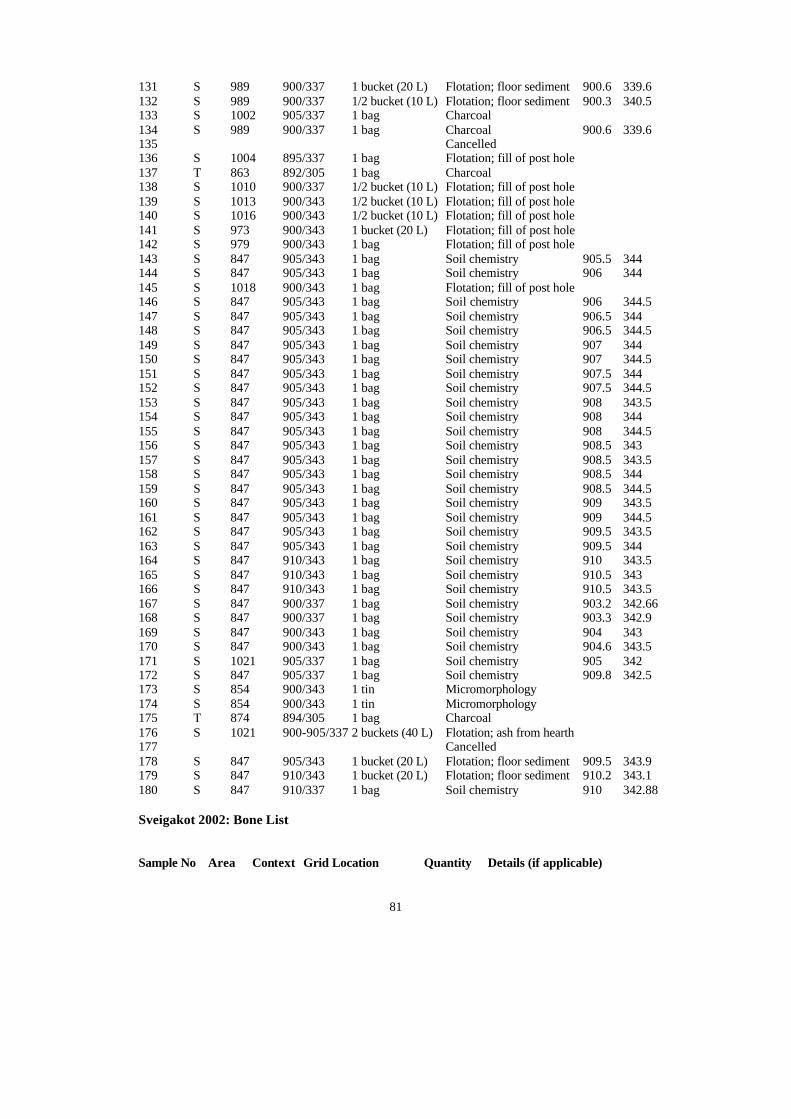
81
131 S 989 900/337 1 bucket (20 L) Flotation; floor sediment 900.6 339.6 132 S 989 900/337 1/2 bucket (10 L) Flotation; floor sediment 900.3 340.5 133 S 1002 905/337 1 bag Charcoal 134 S 989 900/337 1 bag Charcoal 900.6 339.6 135 Cancelled 136 S 1004 895/337 1 bag Flotation; fill of post hole 137 T 863 892/305 1 bag Charcoal 138 S 1010 900/337 1/2 bucket (10 L) Flotation; fill of post hole 139 S 1013 900/343 1/2 bucket (10 L) Flotation; fill of post hole 140 S 1016 900/343 1/2 bucket (10 L) Flotation; fill of post hole 141 S 973 900/343 1 bucket (20 L) Flotation; fill of post hole 142 S 979 900/343 1 bag Flotation; fill of post hole 143 S 847 905/343 1 bag Soil chemistry 905.5 344 144 S 847 905/343 1 bag Soil chemistry 906 344 145 S 1018 900/343 1 bag Flotation; fill of post hole 146 S 847 905/343 1 bag Soil chemistry 906 344.5 147 S 847 905/343 1 bag Soil chemistry 906.5 344 148 S 847 905/343 1 bag Soil chemistry 906.5 344.5 149 S 847 905/343 1 bag Soil chemistry 907 344 150 S 847 905/343 1 bag Soil chemistry 907 344.5 151 S 847 905/343 1 bag Soil chemistry 907.5 344 152 S 847 905/343 1 bag Soil chemistry 907.5 344.5 153 S 847 905/343 1 bag Soil chemistry 908 343.5 154 S 847 905/343 1 bag Soil chemistry 908 344 155 S 847 905/343 1 bag Soil chemistry 908 344.5 156 S 847 905/343 1 bag Soil chemistry 908.5 343 157 S 847 905/343 1 bag Soil chemistry 908.5 343.5 158 S 847 905/343 1 bag Soil chemistry 908.5 344 159 S 847 905/343 1 bag Soil chemistry 908.5 344.5 160 S 847 905/343 1 bag Soil chemistry 909 343.5 161 S 847 905/343 1 bag Soil chemistry 909 344.5 162 S 847 905/343 1 bag Soil chemistry 909.5 343.5 163 S 847 905/343 1 bag Soil chemistry 909.5 344 164 S 847 910/343 1 bag Soil chemistry 910 343.5 165 S 847 910/343 1 bag Soil chemistry 910.5 343 166 S 847 910/343 1 bag Soil chemistry 910.5 343.5 167 S 847 900/337 1 bag Soil chemistry 903.2 342.66 168 S 847 900/337 1 bag Soil chemistry 903.3 342.9 169 S 847 900/343 1 bag Soil chemistry 904 343 170 S 847 900/343 1 bag Soil chemistry 904.6 343.5 171 S 1021 905/337 1 bag Soil chemistry 905 342 172 S 847 905/337 1 bag Soil chemistry 909.8 342.5 173 S 854 900/343 1 tin Micromorphology 174 S 854 900/343 1 tin Micromorphology 175 T 874 894/305 1 bag Charcoal 176 S 1021 900-905/337 2 buckets (40 L) Flotation; ash from hearth 177 Cancelled 178 S 847 905/343 1 bucket (20 L) Flotation; floor sediment 909.5 343.9 179 S 847 910/343 1 bucket (20 L) Flotation; floor sediment 910.2 343.1 180 S 847 910/337 1 bag Soil chemistry 910 342.88 Sveigakot 2002: Bone List Sample No Area Context Grid Location Quantity Details (if applicable)
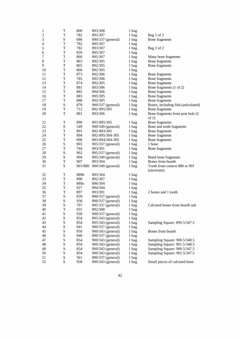
82
1 T 800 893/308 1 bag 2 T 782 893/307 1 bag Bag 1 of 2 3 S 686 890/337 (general) 1 bag Bone fragments 4 T 782 895/307 1 bag 5 T 782 893/307 1 bag Bag 2 of 2 6 T 859 895/307 1 bag 7 T 860 895/307 1 bag Many bone fragments 8 T 863 892/305 1 bag Bone fragments 9 T 865 892/305 1 bag Bone fragments 10 T 866 892/305 1 bag 11 T 873 892/306 1 bag Bone fragments 12 T 785 895/306 1 bag Bone fragments 13 T 874 892/305 1 bag Bone fragments 14 T 881 893/306 1 bag Bone fragments (1 of 2) 15 T 882 894/306 1 bag Bone fragments 16 T 883 895/305 1 bag Bone fragments 17 T 888 892/305 1 bag Bone fragments 18 S 878 900/337 (general) 1 bag Bones, including fish (articulated) 19 T 712 892-895/305 1 bag Bone fragments 20 T 881 893/306 1 bag Bone fragments from post hole (2
of 2) 21 T 890 893-895/305 1 bag Bone fragments 22 S 549 900/349 (general) 1 bag Bone and tooth fragments 23 T 891 892-893/305 1 bag Bone fragments 24 T 894 892-895/304-305 1 bag Bone fragments 25 T 896 893-894/304-305 1 bag Bone fragments 26 S 903 905/337 (general) 1 bag 1 bone 27 T 744 893/301 1 bag Bone fragments 28 S 902 895/337 (general) 1 bag 29 S 904 895/349 (general) 1 bag Burnt bone fragments 30 T 907 893/304 1 bag Bones from hearth 31 S 901/880 900/349 (general) 1 bag Tooth from context 880 or 901
(uncertain) 32 T 889b 895/304 1 bag 33 T 898 892/307 1 bag 34 T 889a 896/304 1 bag 35 T 927 894/304 1 bag 36 T 897 893/301 1 bag 2 bones and 1 tooth 37 S 839 890/337 (general) 1 bag 38 S 936 890/337 (general) 1 bag 39 S 797 895/337 (general) 1 bag Calcined bones from hearth ash 40 T 931 892/308 1 bag 41 S 939 900/337 (general) 1 bag 42 S 854 895/343 (general) 1 bag 43 S 854 895/343 (general) 1 bag Sampling Square: 899.5/347.5 44 S 941 900/337 (general) 1 bag 45 S 950 900/343 (general) 1 bag Bones from hearth 46 S 946 890/337 (general) 1 bag 47 S 854 900/343 (general) 1 bag Sampling Square: 900.5/348.5 48 S 854 900/343 (general) 1 bag Sampling Square: 901.5/348.5 49 S 854 900/343 (general) 1 bag Sampling Square: 900.5/347.5 50 S 854 900/343 (general) 1 bag Sampling Square: 901.5/347.5 51 S 561 890/337 (general) 1 bag 52 S 958 900/343 (general) 1 bag Small pieces of calcined bone

83
53 S 974 900/343 (general) 1 bag Bone from the stake hole 54 S 983 895/337 (general) 1 bag 55 S 989 900/337 (general) 1 bag Sampling Square: 900.6/339.6 56 S 989 900/337 (general) 1 bag Sampling Square: 900.3/340.5 57 S 1006 900/337-343 (general) 1 bag