ACTIVITES ORGANISEES EN 2008 ACTIVITIES … · 6 • Synthèse hydrogéologique et qualité des...
63
Strasbourg, 26 March 2009 AP/CAT (2009) 5 Bil. ACCORD EUROPEEN ET MEDITERRANEEN SUR LES RISQUES MAJEURS (EUR-OPA) EUROPEAN AND MEDITERRANEEN MAJOR HAZARDS AGREEMENT (EUR-OPA) RESEAU DES CENTRES EURO-MEDITERRANEENS SPECIALISES DE L'ACCORD EUR-OPA RISQUES MAJEURS ACTIVITES ORGANISEES EN 2008 NETWORK OF SPECIALISED EURO-MEDITERRANEAN CENTRES OF THE EUR-OPA MAJOR HAZARDS AGREEMENT ACTIVITIES CARRIED OUT IN 2008 www.coe.int/europarisks
Transcript of ACTIVITES ORGANISEES EN 2008 ACTIVITIES … · 6 • Synthèse hydrogéologique et qualité des...
Strasbourg, 26 March 2009 AP/CAT (2009) 5 Bil.
ACCORD EUROPEEN ET MEDITERRANEEN SUR LES RISQUES MAJEURS (EUR-OPA)
EUROPEAN AND MEDITERRANEEN MAJOR HAZARDS AGREEMENT (EUR-OPA)
RESEAU DES CENTRES EURO-MEDITERRANEENS SPECIALISES DE L'ACCORD EUR-OPA RISQUES MAJEURS
ACTIVITES ORGANISEES EN 2008
NETWORK OF SPECIALISED EURO-MEDITERRANEAN CENTRES OF THE EUR-OPA MAJOR HAZARDS AGREEMENT
ACTIVITIES CARRIED OUT IN 2008
www.coe.int/europarisks
2
Tables des matières/ Table of Contents
ALGERIA / ALGÉRIE ....................................................................................................4
CRSTRA - CENTRE EURO-MEDITERRANEEN DE RECHERCHE SICENTIFIQUE ET TECHNIQUE REGIONS ARIDES/ EURO-MEDITERRANEAN CENTER ON SCIENTIFIC AND TECHNICAL RESEARCH IN ARID ZONES (BISKRA)......................................................................................................................................................4
ARMENIA / ARMENIE................................................................................................. 8
ECTR - EUROPEAN INTERREGIONAL EDUCATIONAL CENTRE FOR TRAINING RESCUERS / CENTRE EUROPEEN DE FORMATION INTER-REGIONALE POUR LES SAUVETEURS (YEREVAN) ....................................8
AZERBAIJAN /AZERBAÏDJAN ................................................................................... 15
ECMHT - EUROPEAN CENTRE ON TRAINING AND INFORMATION OF LOCAL AND REGIONAL AUTHORITIES AND POPULATION IN THE FIELD OF NATURAL AND TECHNOLOGICAL DISASTERS / CENTRE EUROPÉEN DE FORMATION DES AUTORITÉS LOCALES ET RÉGIONALES DANS LE DOMAINE DES CATASTROPHES NATURELLES ET TECHNOLOGIQUES (BAKU) .................................................................................................................... 15
BELGIUM /BELGIQUE ............................................................................................... 18
ISPU - HIGHER INSTITUTE OF EMERGENCY PLANNING / INSTITUT SUPERIEUR DE PLANIFICATION D'URGENCE (FLORIVAL .............................................................................................................................. 18
BULGARIA / BULGARIE.............................................................................................23
CSLT - EUROPEAN CENTRE FOR RISK PREVENTION TRAINING AT SCHOOL LEVEL / CENTRE EUROPEEN SUR LA FORMATION SCOLAIRE A LA PREVENTION DES RISQUES (SOFIA).............................................................23
CYPRUS /CHYPRE .....................................................................................................26
BE-SAFE-NET – EUROPEAN CENTER FOR DISASTER AWARENESS THROUGH INTERNET / CENTRE EUROPÉEN POUR LA SENSIBILISATION AUX DESASTRES A TRAVERS INTERNET (NICOSIA)...........................26
FRANCE ..................................................................................................................... 27
CSEM – CENTRE SISMOLOGIQUE EURO-MÉDITERRANÉEN / EUROPEAN MEDITERRANEAN SEISMOLOGICAL CENTRE, (BRUYÈRES-LE-CHATEL) .............................................................................................................27 CERG - EUROPEAN CENTRE FOR SEISMIC AND GEOMORPHOLOGICAL HAZARDS / CENTRE EUROPÉEN SUR LES RISQUES GÉOMORPHOLOGIQUES (STRASBOURG) .................................................................................28
GEORGIA /GEORGIE..................................................................................................33
GHHD - EUROPEAN CENTRE ON GEODYNAMICAL RISKS OF HIGH DAMS / CENTRE EUROPEEN SUR LES RISQUES GEODYNAMIQUES LIES AUX GRANDS BARRAGES (TBILISI) ...........................................................33
GREECE / GRECE .......................................................................................................38
ECFF - EUROPEAN CENTRE ON FOREST FIRES / CENTRE EUROPEEN SUR LES FEUX DE FORETS (ATHENS)..................................................................................................................................................................38
LUXEMBURG / LUXEMBOURG................................................................................. 40
ECGS - EUROPEAN CENTRE FOR GEODYNAMICS AND SEISMOLOGY / CENTRE EUROPEEN DE GEODYNAMIQUE ET DE SISMOLOGIE (WALFERDANGE)..............................................................................40
MALTA / MALTE ........................................................................................................43
ICOD - EURO-MEDITERRANEAN CENTRE ON INSULAR COASTAL DYNAMICS / CENTRE EUROPEEN DE LA DYNAMIQUE COTIERE INSULAIRE (LA VALETTA)........................................................................................43
PORTUGAL ................................................................................................................45
CERU - EUROPEAN CENTER ON URBAN RISKS / CENTRE EUROPEEN SUR LES RISQUES URBAINS (LISBON)..................................................................................................................................................................45
ROMANIA / ROUMANIE.............................................................................................46
ECBR - EUROPEAN CENTRE FOR REHABILITATION OF BUILDINGS / CENTRE EUROPEEN POUR LA REHABILITATION DES BATIMENTS, (BUCHAREST) ......................................................................................46
RUSSIAN FEDERATION / FEDERATION DE RUSSIE ..................................................48
ECNTRM- EUROPEAN CENTER FOR NEW TECHNOLOGIES IN MANAGEMENT RISKS / CENTRE EUROPEEN DES NOUVELLES TECHNOLOGIES POUR LA GESTION DES RISQUES (MOSCOW).....................................................48
3
SAN MARINO / SAINT MARIN....................................................................................50
CEMEC- EUROPEAN CENTER FOR DISASTER MEDICINE/ CENTRE EUROPÉEN POUR LA MÉDECINE DE CATASTROPHE (SAN MARINO)....................................................................................................................50
TURKEY / TURQUIE................................................................................................... 51
AFEM - EUROPEAN NATURAL DISASTERS TRAINING CENTRE / CENTRE EUROPEEN DE FORMATION SUR LES RISQUES NATURELS (ANKARA) .................................................................................................................. 51
UKRAINE...................................................................................................................58
TESEC - EUROPEAN CENTRE OF TECHNOLOGICAL SAFETY / CENTRE EUROPEEN DE SECURITE TECHNOLOGIQUE (KIEV)............................................................................................................................58
4
ALGERIA / ALGÉRIE
CRSTRA - Centre Euro-Méditerranéen de recherche sicentifique et technique régions arides/ Euro-Mediterranean Center on scientific and technical research in arid zones
(Biskra) 1. Activités menées dans le cadre de l’Accord EUR-OPA Risques Majeurs : Organisation d’un colloque sur l’Aridoculture : OPTIMISATION DES PRODUCTIONS AGRICOLES
ET DEVELOPPEMENT DURABLE. Compte tenu de l’importance des territoires arides et semi arides d’une part et des impacts économiques et écologiques sur ces régions sous l’influence directe et indirecte des changements climatiques d’autre part, nous avons jugées impératif d’organiser une rencontre scientifique devant prendre en charge les problématiques spécifiques, les difficultés rencontrées et les possibilités de leur prise en charge scientifiquement. Le colloque qui a eu lieu le 13 et 14 Décembre 2008 a regroupé 200 participants dont 90 intervenants par des communications orales ou affichées. L’expertise scientifique a eu lieu et a retenu les travaux entrant dans les thématiques du colloque. Après une séance plénière, les participants ont animé trois ateliers distincts se rapportant aux trois axes suivants : Axe 1 - Environnement aride et gestion intégrée des ressources naturelles Thème 1 - Caractérisation de l'environnement aride et impact sur l'aridoculture Thème 2 - Gestion des ressources naturelles et non conventionnelles • Eaux, sols, diversité biologique. • Valorisation et développement des énergies renouvelables et des nouvelles technologies en aridoculture. Axe 2 – Agro biodiversité, agro-éco-systèmes et optimisation des techniques agronomiques Thème 1 - Adaptation aux contraintes du milieu et valorisation. Thème 2 - Agro-écosystèmes et leur efficience Thème 3 - Optimisation des techniques agronomiques. Axe 3 - Gestion de l'espace et contraintes socio-économiques Thème 1 - Organisation de l'espace, contraintes et atouts : répartition des activités et des infrastructures pour un développement durable. Thème 2 - Formation et organisation participative des acteurs du développement agricole intégré. Thème 3 - Programmes de développement agricole s en zones arides : rôle de l'Etat et des acteurs de la société civile. Thème 4 - Relations agriculture – autres activités [polyactivité : tourisme, artisanat, industries agroalimentaires (conditionnement et transformation des produits et sous produits agricoles) et agro-industries (production de moyens et facteurs de production)] pour un développement durable. Des études de cas ont été présentes au sein des différents axes thématiques. Le colloque a abouti à des recommandations générales et spécifiques techniques et scientifiques devant être prise en charge afin de valoriser les systèmes de production et les écosystèmes existants sans compromettre l’environnement et la vie humaine qui en dépend dans les zones arides. Les actes sont en cours de publication pour être éditer en 2009. Participation du CRSTRA aux activités cooedonnées : A. Participation à Istanbul à l’Atelier international « Vers Une Nouvelle Gouvernance des Risques Naturels ». Communication : La désertification /ensablement : un risque redoutable de plus en plus pris en charge par les pouvoirs publics en Algérie. B. Participation à Paris au groupe de travail retenu par l’Accord EUR-OPA sur le rôle des autorités locales dans la gestion des risques majeurs. Communication : Rôle des autorités locales dans la gestion des risques naturels en Algérie. C. Participation au Be Safe Net pour le volet risques liés à la sécheresse et aux changements climatiques. (contribution au questionnaire) Publications du CRSTRA en 2008 :
5
• Actes des journées internationales sur l’impact des changements climatiques sur les régions arides et semi arides tenues le 15-16 et 17 décembre 2007.
• Ouvrages d’éducation/sensibilisation sur les risques liés aux changements climatiques destiné aux enfants (expériences pilotes menées en Avril 2007). 2. Activités de recherche permanente: Conformément à ses missions, le CRSTRA mène au quotidien des activités sur des projets de recherche à travers les différentes divisions et selon les objectifs ciblés de chacune comme indiqué : Ressources biologiques en zones arides Contribuer à la préservation et à la gestion rationnelle des bios ressources Gestion des ressources en eau et des sols arides Elaboration d’outils de quantification et de gestion quantitative et qualitative de la ressource Développement économique, social et culturel des zones arides Etude du mode de développement socio-économique et culturel Surveillance de la désertification Tenir une veille écologique au niveau des espaces steppiques et oasiens par le développement d’un système d’alerte précoce Quant aux niveaux des deux stations expérimentales sont menées les activités sur : La valorisation des Bio ressources locales, la mise au point de normes et de référentiels relatifs à l’irrigation, la fertilisation, la lutte biologique et la lutte contre l’ensablement. 3. Les activités associées :
• Ateliers de formation sur les zones humides en régions arides.
• Journée Mondiale de l’eau : Journée d’étude et de sensibilisation à la gestion de la ressource en eau dans les régions arides et semi arides.
• Séminaire interne d’évaluation des projets de recherche en cours.
• Cours de formation en statistiques au profit des chercheurs permanents du centre.
• Cours sur les outils méthodologiques de recherche et développement et la dynamique de groupe. 4. Communications Nationales
• La Convention de RAMSAR Genèse, Principes fondateurs et critère de classification des zones humides » Atelier régional sur les zones humides, du 02 au 5 Février, CRSTRA, Biskra
• Qu’appelle-t-on « zone humide », Atelier régional sur les zones humides 02 au 5 Février, CRSTRA, Biskra.
• Localisation des zones humides de la wilaya de Biskra, Atelier régional sur les zones humides 02 au 5 février, CRSTRA, Biskra.
• L’importance socio-économique des zones humides en régions arides en Algérie, atelier de formation sur les zones humide du 02 au 05 Février 2008.
• La richesse faunistique et floristique des zones humides de la wilaya de Biskra, Atelier régional sur les zones humides 02 au 5 février, CRSTRA, Biskra
• Ressource en eau du système aquifère du Sahara Septentrienal (SASS). Journée d’étude et de sensibilisation à la gestion de la ressource en eau dans les régions arides et semi-arides, Centre de Recherche Scientifique et Technique sur les Régions Arides et Semi-aride, Biskra (Algérie), le15 Mars 2008. (Communication affichée).
• Constat de l’évolution de la qualité des sols irrigués dans la région Sud-Ouest de Biskra. Journée d’étude et de sensibilisation à la gestion de la ressource en eau dans les régions arides et semi-arides, Centre de Recherche Scientifique et Technique sur les Régions Arides et Semi-aride, Biskra (Algérie), le15 mars 2008. (Communication affichée).
• Diagnostic des rejets des eaux usées de la ville de Biskra. Journée d’étude et de sensibilisation à la gestion de la ressource en eau dans les régions arides et semi-arides, Centre de Recherche Scientifique et Technique sur les Régions Arides et Semi-aride, Biskra (Algérie), le15 mars 2008. (Communication affichée).
• Etat de sollicitation des aquifères et conséquences de la surexploitation de la nappe des calcaires à Tolga. Journée d’étude et de sensibilisation à la gestion de la ressource en eau dans les régions arides et semi-arides, Centre de Recherche Scientifique et Technique sur les Régions Arides et Semi-aride, Biskra (Algérie), le15 mars 2008. (Communication affichée).
6
• Synthèse hydrogéologique et qualité des eaux souterraines de la nappe de Tolga. Journée d’étude et de sensibilisation à la gestion de la ressource en eau dans les régions arides et semi-arides, Centre de Recherche Scientifique et Technique sur les Régions Arides et Semi-aride, Biskra (Algérie), le15 mars 2008. (Communication affichée).
• Lac El Ayata Richesse avifaunistique en plein milieu aride, journée d’étude nationale sur la protection des végétaux, INA Alger du 7 au 8 Avril 2008
• Première données sur les oiseaux d’eau du Lac El Ayata (El Oued), journée d’étude Nationale sur les écosystèmes aquatiques, Université de Skikda, les 24 et 25 Mai 2008.
• Etude de la valorisation de la vigueur de croissance, la capacité de translocation des hydrates de carbone et le rendement chez le blé dur (Triticum durum Desf.) sous conditions semi-arides.
• Valorisation des ressources naturelles dans les zones semi-arides. Oum El Bouaghi 03 - 04 Novembre 2008.
• Des potentialités phoenicicole à valoriser au niveau des Aurès Nememcha (poster) sous conditions semi-arides. Valorisation des ressources naturelles dans les zones semi-arides. Oum El Bouaghi 03 - 04 Novembre 2008
• Télédétection et action anthropique (mouvement de sable et désertification de la région des Zibans) cas de la région d’El hadjeb et Ain Benaoui Biskra Algérie le 10, 11 et 12 Novembre 2008.
• Produits et sous produits du palmier dattier, un créneau potentiel, une opportunité à saisir pour un développement durable en Algérie »valorisation des produits et sous produits du palmier dattier. Journée Nationale de l’Artisanat Biskra, Novembre 2008.
Lors de cette communication une présentation de fiche technique d’un projet réalisable a été faite. Ce projet vise trois objectifs :
- la préservation de l’environnement par la récupération des déchets urbain et agricoles - la valorisation des sous produits en milieu agricole. - la création d’emploi et la production de Bio fertilisant local disponible, financièrement
accessible pour les sols agricoles et les espaces verts. • Communication orale « La pratique de l’irrigation localisée : exemple d’une zone saharienne
irriguée » colloque international sur l’Aridoculture (CRSTRA) Biskra Décembre 2008.
• Communication affichée « L’utilisation d’eau dans le Zab el Gharbi : un système d’irrigation économe et émergence de l’individualisme, cas de la commune d’El Ghrous » colloque International Sur l’Aridoculture (CRSTRA) Biskra Décembre 2008.
5. Communications Internationales • Communication orale à la 3ème Conférence internationale sur l’architecture et le développement
durable, Stratégies et Perspectives du 08 au 10 Avril 2008, qui s’intitule «La participation des habitants de la ville algérienne : du discours… à l’acte! ». (Université Mohamed Kheider - Biskra).
• La désertification /ensablement : un risque redoutable de plus en plus pris en charge par les pouvoirs publics en Algérie, atelier international sur : « Vers Une Nouvelle Gouvernance des Risques Naturels », Octobre 2008 à Istanbul.
• Changement de la qualité des sols irrigués de la plaine d’El Outaya (Biskra) : Données de base et hypothèses. Colloque International sur l’Aridoculture « Optimisation des productions agricoles et développement durable », Centre de Recherche Scientifique et Technique sur les Régions Arides et Semi-aride, Biskra (Algérie), les 13 et 14 décembre 2008. (Communication orale).
• Bio écologie des populations d’Outardes Houbara (Clamydotis undulata) dans la région de Biskra : Colloque international sur l’optimisation des productions agricoles et développement durable CRSTRA, Biskra du 13 au 14 décembre 2008
• Rôle des autorités locales dans la gestion des risques naturels en Algérie. Rôle des autorités locales dans la gestion des risques majeurs, accord EUR-OPA « Risques Majeurs », Paris Décembre 2008.
• Le palmier dattier dans les Ziban : un patrimoine a préservé. Colloque international sur l’optimisation des productions agricoles et développement durable CRSTRA, Biskra du 13 au 14 décembre 2008
• Changement de la qualité des sols irrigués de la plaine d’el Outaya (Biskra) : données de base et Hypothèses. Colloque international sur l’optimisation des productions agricoles et développement durable CRSTRA, Biskra du 13 au 14 décembre 2008
• La pratique de l’irrigation localisée : exemple d’une zone saharienne irriguée Colloque international sur l’optimisation des productions agricoles et développement durable CRSTRA, Biskra du 13 au 14 décembre 2008
• Colloque international sur l’optimisation des productions agricoles et développement durable CRSTRA, Biskra du 13 au 14 décembre 2008
7
• Essai de pilotage Tensitométrique d’irrigation sur palmier dattier du site d’El Outaya, Biskra Colloque international sur l’optimisation des productions agricoles et développement durable CRSTRA, Biskra du 13 au 14 décembre 2008
• Comportement des vitro-plants de palmier dattier, variété Medjhoul, dans la région du Souf. Colloque international sur l’optimisation des productions agricoles et développement durable CRSTRA, Biskra du 13 au 14 décembre 2008.
• Structure foliaire et rendement chez le blé dur (triticum durum desf.) Sous conditions semi arides. Colloque international sur l’optimisation des productions agricoles et développement durable CRSTRA, Biskra du 13 au 14 décembre 2008.
• L’élevage du camelin dans la région des Ziban : contraintes et perspectives Colloque international sur l’optimisation des productions agricoles et développement durable CRSTRA, Biskra du 13 au 14 décembre 2008.
• L’utilisation d’eau dans le Zab el Gharbi : un système d’irrigation économe et émergence de l’individualisme Colloque international sur l’optimisation des productions agricoles et développement durable CRSTRA, Biskra du 13 au 14 décembre 2008.
• Valorisation des quelques espèces condimentaires, médicinales et aromatiques adaptées aux régions arides. Colloque international sur l’optimisation des productions agricoles et développement durable CRSTRA, Biskra du 13 au 14 décembre 2008.
• Les systèmes d’élevage des zones arides et leurs environnements : cas des Ziban. Colloque international sur l’optimisation des productions agricoles et développement durable CRSTRA, Biskra du 13 au 14 décembre 2008.
• Croisement des données satellites avec des données exogènes pour l’estimation des superficies agricoles : Cas de la région de Sidi Bel Abbès. Colloque international sur l’optimisation des productions agricoles et développement durable CRSTRA, Biskra du 13 au 14 décembre 2008.
• Essai de la lutte biologique par la coccinelle Algerica sur les cultures sous serres. Colloque international sur l’optimisation des productions agricoles et développement durable CRSTRA, Biskra du 13 au 14 décembre 2008.
5. Edition / Publication: • Elaboration de la carte des Géo sites de Biskra.
• Elaboration de la carte de vulnérabilité de la nappe phréatique de Biskra.
• Publication du Jara N°7 au cours de finalisation.
• Un N° spécial est prévu avec les travaux du centre 6. Le CRSTRA et l’Environnement extérieur : Le CRSTRA a développé et s’attèle à développer davantage des relations sectorielles et avec les autorités locales. Ces relations se traduisent par des interventions et/ou des concertations dans un sens voire dans les deux sens. Afin de contribuer au développement socioéconomique. Le centre entretient également des relations à l’échelle internationale à travers: 1- L’intervention des chercheurs aux différentes rencontres scientifiques. 2- Les accords tels que l’Accord Eur-Opa Risques Majeurs dont il est membre. 3- Les conventions avec :
- L’Université d’Arizona /USA; - Centre Ravello Cagliari /Italie; - CNRS, Aix en Provence /France
8
ARMENIA / ARMENIE
ECTR - European Interregional Educational Centre for Training Rescuers / Centre Européen de Formation Inter-Régionale pour les Sauveteurs (Yerevan)
1. TRAINING IN FIRST AID SKILLS WITH ASSISTANCE OF THE ARMENIAN RESCUERS-INSTRUCTORS TRAINED WITHIN THE FRAMEWORK OF THE ARMENIAN–FRENCH JOINT PROJECT WITH INVOLVEMENT OF THE ECTR AND API OBJECTIVE OF THE PROJECT
• Training population in first aid skills and elements of rescue operations according to the European methodic.
• Organization of training courses for training first aid specialists as well as for training monitors (second grade instructors) for mountanious regions of Armenia, often isolated from the relevant regional centres in winter time and also in emergencies.
• Organization of training courses for training first aid specialists as well as for training monitors (second grade instructors) and the first grade instructors for training the monitors from the students (members of the Alpine Club of Yerevan State Medical University).
• The trained monitors (second grade instructors) and first grade instructors are assigned first of all to organize wide scale training of the students of State Medical University in practical skills of first aid and basis of rescue operations.
In this way we will manage to resolve two significant tasks:
• To have a great number of specialists in administering first aid and moreover possessing the basis of rescue operations who can be involved at major large scale emergencies as well as who can show qualified first aid to victims at possible emergencies bearing everyday nature.
• To strengthen first year students of State Medical University practical knowledge through acquisition of practical ones in the disaster medicine area.
• trained to the rang of monitors and first grade instructors, and will be included into a large scale process of training various segments of population in skills of administering first aid.
• Training in first aid and elements of rescue operations of the corresponding regular subdivisions of peacekeeping battalion of the Republic of Armenia.
• Training in first aid skills basing on the European methodic for the rescuers of special rescue detachments and the members of rescue associations of students and volunteers.
RESULTS OBTAINED 1. If in 2006 special attention was focused on the organization of training courses in outmost, isolated, mountainous, not easily accessible regions of the Republic, in 2007 the ECTR concentrated its attention on organizing training in first aid skills basing on the European methodic for the rescuers of special rescue detachment, the members of rescue association of students and telephone operators. 2. In 2008 the training first aid courses as well as theoretical and practical training courses on rescue operations basis were also organized for the below other two civil groups. The first trainees’ group composed 18 members from the YMCA public organization (Union of young Christians, aimed at educational support to children) for ages 15-25, seven people from which had a university degree. The teaching course was organized from 16 June to 12 July. The course participates who showed good results at exams were awarded the European certificates with the right to administer first aid; the 6 best among them later will be trained for monitors (the second grade instructors with the right to train first aid to other people). The children from the children Home “Nadejzda”, the Gumry city composed the second group. The training was provided to 16 students for ages 14-18 (grades 8, 9 and 10). The 11 students who successfully passed the exams were awarded the European certificates with the right to administer first aid. The teaching course was organized from 21 July to 16 August. 2. ENABLING THE COORDINATION OF ACTIVITIES IN A DISASTER RISK REDUCTION AREA IN THE REPUBLIC OF ARMENIA OBJECTIVE OF THE PROJECT
• Acknowledging top officials, specialists and wide public in Armenia with key priorities and documents on disaster risk reduction, civil protection and sustainable development adopted by relevant international organizations in the most significant Conferences and Seminars.
9
• Acknowledging top officials and specialists from relevant Ministries and Departments, regional governments and local self-governmental bodies, alongside with the school community officials and other educational, scientific, economical and cultural community leaders with key documents and priorities adopted at the EUR-OPA Ministerial Meetings.
• Preparing proposals to meet strategic goals and to choose priority directions for the Government of Armenia and Emergency Management Administration in the field of disaster risk reduction and sustainable development.
• Participating in the organization and holding in Armenia of international, national, regional and local Conferences, Workshops, Round Tables, teaching and practical courses,.
RESULTS OBTAINED 1. In 2007-2008, the documents adopted at the 11-th Ministerial Session of the Agreement ( Marrakech, Morocco, 31 October 2006) were translated and delivered to the Spatial Planning Ministry, the Ministry of Foreign Affairs and the Armenian Rescue Service: 2. In 2008 was translated in Armenian and submitted to the newly established in 2008. We developed a short variant of the Recommendation 1829(2008) on “Trans-frontier cooperation” of the Council of Europe’s Parliamentary Assembly and submitted it to the Emergency Management Ministry and to the Ministry of Foreign Affairs. The document includes preparing the proposals on establishing a National Platform on disaster risk reduction. 3. In 8-9 September 2008 in collaboration with the Director of TESEC Kyiv, Ukraine and corresponding leading officials and specialists of the Emergency Management Ministry of Armenia and other concerned Ministries and Departments a Round Table has been organized in town of Metzamor - the partner-town of the Armenian NPP. There was held the meeting with local authorities of Metzamor and other human settlements situated in direct closeness with the Armenian NPP, to appreciate the propositions concerning the using of the best international experience (in particular following learning from the Chernobyl legacy) for the improvement of the cooperation among local authorities and NPP to raise the population safety near the operating NPP. Medical and educational representatives actively participated in the Round Table discussions. The discussion outcomes have been presented at the International Workshop in Kiev in September 2008. 4. For strengthening national disaster preparedness and risk reduction capacities in Armenia, the Ministry of Territorial Administration (as Implementing partner), UNDP and Armenian Rescue Service (as Responsible parties) and ECTR began implementation in the Ararat Marz (region) of Armenia a pilot Local Level Risk Management module. Within the above Module the two day courses on improving preparedness of local authorities to actual or impending disasters were organized. Organizers: representatives of UN Mission in Armenia, Academy of Crisis Management of the Emergency Management Administration and European Educational Interregional Centre for training rescuers Courses Participants: representatives from 18 communities of the Ararat region among them:
- Community Chairmen and Deputy Chairmen - Directors of school and trainers of military preparedness subject - Directors of pre-school establishments - Directors of libraries - Directors of post-offices - Hospitals Chief Doctors.
The courses were taught in three stages, each stage attended by representatives from 6 communities. Course Program:
1) The natural and technological accidents likely to occur in the territory of the region, the ways to prevent them.
2) Organization procedures for establishing communication and warning links, the order of compiling operative disaster datasets and information exchange.
3) Legal normative base to organize and provide the protection to the population. 4) The order of organizing and implementing evacuation procedures. 5) Planning - Action Plans for local authorities if the disaster is actual or there is a threat of its
arising. Before starting the courses the trainees were past to testing through specially developed Program tests. At the end of each day a drill exercise was conducted. After the completion of the courses the trainees were again put to testing to evaluate the level of the acquired skills. During training sessions the trainees were given the tasks containing the questionnaires requiring practical knowledge of the material taught. Commencing November 2008, the checking of the given tasks was carried out.
10
After the completion of the courses, the analyses of the courses sensibility, Program coverage and thematic as well as comments and proposals drawn on the feed back from the participants were taken into account targeted for running the similar courses in other regions of the Republic in the future. In November 2008 the lectures’ and Programs’ materials were compiled as a teaching Manual, duplicated into necessary copies and disseminated to the communities of the Ararat region. 3. HARMONIZATION OF THE LEGISLATION WITH THE EUROPEAN UNION (SECONDARY LEGISLATION), MEMBER – STATES OF THE EUROPEAN UNION AND THE REPUBLIC OF ARMENIA IN THE AREA OF CIVIL PROTECTION, PREVENTION OF EMERGENCIES AND THEIR RESPONSE OBJECTIVE OF THE PROJECT
• Harmonization of legislations of European union, EU member states and Armenia in the area of civil protection, prevention of emergencies and their response.
• Evaluation of the extent which the legislation of Armenia conforms to the EU legislation:
• Development of proposals for that harmonization through alleging the legislative Acts that is subject to alterations and additions and those that have to be newly adopted.
• Acknowledgement with legal tools and the best practices to apply effectively the provisions of relevant international documents in the field of awareness raising of the local communities about disaster risks, transparency and democracy in the decision making.
RESULTS OBTAINED 1. In 2005, the ECTR analyzed the secondary Legislation of the European Union in the fields of Civil Protection and Sustainable Development and the relevant Legislation of Armenia. In 2006 we concentrated on making better analyses and on improving the comparative characterizes of the secondary legislation of the European Union and Armenia. Besides, one can especially notice the preciseness of their wording, a composite way of their submitting in the appropriate legislative Acts of the European Union and the existence of mechanisms enabling their steadily exercising. The outcomes of analyses and the developed proposals have been summarized in the paper “Harmonization of legislation of the Republic of Armenia and the European Union in the civil protection and sustainable development areas” planned to be published commencing 2008 within the the book:”About some most significant windows towards ensuring safety in the Republic of Armenia”. The ECTR elaborated also the summarized proposals aiming to improve and amend in 2007-2009 the existing Laws of Armenia in the given area, along with the proposals for developing innovative Acts. 3. In 2008 the outcomes of comparative analyzes of the secondary Legislation of the European Union in the fields of Civil Protection and Sustainable Development and the relevant Legislation of Armenia submitted by the ECTR in detail in section for each Act from the 14 legislative and normative Acts of the European Union were considered within the framework of the present Program. The outcomes of comparing specific Acts of the European Union with relevant legislative and normative Acts of the Republic of Armenia quoted. Particular differentiations (what legislative and normative Acts of the Republic of Armenia are in conformity with specific European Union Acts and what are not; what is the difference between them) demonstrated. The European Interregional Centre for training rescuers also submitted the proposals concerning harmonization of the Legislations of the European Union and the Republic of Armenia in the filed of civil protection, along with listing those legislative Acts that are subject to specification and alteration and those that should be newly developed. 4. The updated variant of the “Constitution and safety”, targeted for the government and the relevant authorities, has been completed, developed, edited and submitted for publication. 5. Building on the Recommendation 1829(2008) on “Trans-frontier Co-operation” of the Parliamentary Assembly of the Council of Europe, a document has been prepared preliminary variant of the proposals justifying the expedience to ratify by Armenia the 1980 Madrid Convention (European Convention on Trans-frontier Co-operation between Territorial Communities or Authorities) and two proposals added in 1995 and 1998 respectively. 4. DEVELOPMENT OF THE “SAFE LIFE ACTIVITIES BASIS IN EXTREME SITUATIONS” MANUAL FOR EXPERIMENTAL TEACHING IN EDUCATIONAL ESTABLISHMENTS OBJECTIVE OF THE PROJECT The developing, deepening and final creating a Manual: “Safe life activities basis” that will underlie the forming in students a reasoned and responsible attitude to their personal safety and safety of other people, to their ability to possess skills enabling to safe their lives and health under unfavourable, threatening circumstances and to provide assistance to the others. An ancient saying goes:” Be able to
11
save yourself and the thousands around you will be saved”; in case you have failed to save yourself - try at least to improve the protection. Forming a person, who is, first of all, safe for himself, surrounding people, the environment and who is oriented towards kindness, creation and development and able to protect himself, a social community and the environment against external threats. RESULTS OBTAINED In 2006 the ECTR has continued developing a fundamental teaching Manual (a Text book) for schools: “The basis of survival in emergencies”. The teaching Manual drawn on more than 30 thematic chapters addressing dimensions in safe living that have been previously developed and updated through an inherent long experience of experimental teaching in schools of the Republic. In 2007 the ECTR has conducted updating and systematization of previously developed materials as well as the listed below Teaching Module’s chapters have been developed:
• Basis of behaviour in extreme situations
• Accidents in every day life
• Ensuring safety at dealing with nature
• Ensuring safety in the armed conflict zones
• Children and terrorism
• Specifics of service in the Army
• “Behaviour in travelling abroad status” (Chapter 1 “Respect for alien customs”) In 2008 the final variants of additional informational modules for municipalities at special risk have been developed: one for the municipalities at probable radiological risk, another for the municipalities having enterprises where hazardous materials are produced, used or stored and the third one for municipalities situated in flood prone areas close to reservoir dikes. The draft English translation of the following information materials have been prepared:
• A manual for the population on how to act when r a d i a t i o n p o l l u t i o n is real or seems imminent (the priorities for action to be undertaken by the population)
• A manual for the population on how to act when a f l o o d is real or seems imminent (the priorities for action to be undertaken by the population)
• A manual for the population on how to act when c h e m i c a l p o l l u t i o n is real or seems imminent (the priorities for action to be undertaken by the population)
• A manual for the population on how to act when a n e a r t h q u a k e is real or seems imminent (the priorities for action to be undertaken by the population)
These materials intend to be included into the relevant chapters of the project Manual. 5. PROGRAM OF DEVELOPING AND INSTITUTING SPECIAL TESTS FOR SCHOOL ADMINISTRATION, TEACHERS AND STUDENTS’ PARENTS TO ASSESS SAFETY OF SCHOOLS AND OTHER EDUCATIONAL ESTABLISHMENTS OBJECTIVE OF THE PROJECT Developing and implementing special tests for school administration, teachers and parents to assess the extent, to which their school is secure, to undertake preventive measures to reduce risks as well as to respond adequately to an imminent natural and a man-made disaster or to a terrorist attack or to a threat of such an attack. RESULTS OBTAINED 1. Created in 2006-2007, “The Program of developing and instituting special tests for school administration, teachers and students’ parents to assess safety of schools and of other educational establishments” has been profoundly reworked out and updated in 2008. The Tests for school administration and teachers are targeted to identify the level to which their education establishment is ready to eliminate natural, man-made and other disaster risks and to respond adequately to them and also if it is threatened by a possible terrorist attack. The Tests for parents enable them to highlight levels of a culture of safety, as well as of parents’ preparedness to recognize a hazard and undertake preventive measures aiming to reduce risk of involving children into extreme situations and also to act rationally if an emergency incident occurred in their school. Tests outcomes can serve as basis for designing recommendations on reducing vulnerability of schools, improving preparedness of the school staff to act adequately in particular disaster and updating the disaster preparedness Plans. The work outcomes, translated in English, have been presented by the ECTR at the Workshop “Disaster reduction at school-Building safer school communities” held on 29-30 October, 2007 in Paphos, Cyprus. 2. In the first semester of 2008, the ECTR has reviewed and polished the basic tests and general recommendation for assessing and increasing safety for school administration and parents developed in 2006-2007. In the second semester, the final version of the basic tests and general
12
recommendations has been discussed, agreed upon and approved with the involvement of the Crisis Management Academy; pilot schools are to be chosen to disseminate the material. 6. PSYCHOLOGICALLY SIGNIFICANT QUALITIES OF A RESCUER WITHIN THE PROFESSIONAL FITNESS SYSTEM OBJECTIVE OF THE PROJECT To highlight professional qualities of a rescuer having a high degree of prominence allowing the determination of psychological selection policy and professional fitness evaluation technique:
• By analyzing the special literature to identify psychological aspects of professional fitness and methodological principles underlying the evaluation of a rescuer’s psychological qualities
• To detect a rescuer’s psychological qualities characterizing his self-regulation level and to identify adequate professional requirements
• To chose psychological methodologies giving the most precise evaluation of a extent to which a rescuer’s qualities under study can be translated
• To track the links between the rescuer’s qualities under study and the degree of the prominence that these links may have in evaluating his/her professional fitness.
RESULTS OBTAINED 1. Assessments have been carried out in Armenia between 2006 and 2008 with the support of ECTR: a group of 30 rescuers from an Immediate Response Team of the Ministry of Emergency Management as well as a group of 30 non-persons having no professional rescue experience were tested. The paper draws attention to the scientific high-tech, in terms of suggested evaluation technique for measuring a rescuer’s professional fitness. Theoretical and practical significance of this work is quoted. 7. “EXTREME PSYCHOLOGY” OBJECTIVE OF THE PROJECT Psychological impact of hazardous events in different people varies; human safety under extreme circumstances in many respects will depend on their ability to maintain self-control. This work is challenged to:
• create a universal teaching Manual in Armenian to teach methods of emotional-will- self -regulation
• serve as a Manual to teach rescuers, peace keepers, other specialists operating in extreme circumstances as well vast lays of the population, including school - and higher institution students
• form and develop in people ( be it a rescuer, an adult or a young man) an ability to maintain his/her self-control
• teach to assess correctly of what is going around and be able to make adequate decisions which is provided only if this condition ( maintaining one’ s self-control) is met.
Teaching the « Extreme psychology » is aimed at building a system that will impart special knowledge, skills and capacity needed for quick adjustment of oneself with new situation as well as for developing his/her inner readiness to deal with potentially most dangerous life activities. RESULTS OBTAINED In 2006-2007 a preliminary variant of brochure: “Extreme psychology” was created. In 2008 some sections of the brochure were expanded, the work updated and enriched. The brochure’s brief contents 1. Psychological basis ( some recommendations):
• is it possible to learn to control oneself
• correct self –evaluation
• coping with failures
• not to speed up the events ( to stop for some time, but not to retreat in the face of difficulties )
• proving protection against psychological trauma
• ineffectiveness in pursuing a “Burning bridges” strategy
• ability of responding negatively
• ability of establishing easy and simple communication links. 2. Psychology of human conduct in times of crisis.
• personal livelihood strategy
• self -confident conduct
• personal features required to dealing successfully with a critical situation
13
• in other adequate circumstances- high spirits will increase your chances for success (“My spirits are my castle”)
3. Some recommendations on how to maintain one’s self -control in a threatening situation.
• recommendations that are to be brought for consideration to disaster victims. 4. Basic conduct rules for hostages 5. A list of some books on self - defence aspects. 8. A PROGRAM OF CREATING A MEMORANDUM FIRST AID POCKET BOOK OBJECTIVE OF THE PROJECT A Memorandum first aid pocket book is called to prevent the similar situations and to assist rescuers and volunteers if a need may arise to recollect the acquired knowledge. It is also likely to serve a guide for all those who having this manual at hand can be found into a role of helpers in different emergency situations ranging from natural disasters to other types of accidents and life traumas. For achievement of the above mentioned the following objectives are to be realized:
• creating a Memorandum first aid pocket book that could be helpful in:
• recurrent repetition of the gained knowledge and the reinforcement of acquired skills
• specification of correct actions required if necessary to be fulfilled in a stress situation
• likely administration of first aid to a casualty even by a non trained/ nonprofessional witness. For the sake of convenience and for making showing first aid easier it is necessary to create and institute a Memorandum first aid pocket book whose challenge is to serve:
• a normative document that will attach self confidence to act properly while rendering first aid through the precise identification of a human mandate, potentials, rights and duties, priority for action and consistency in decision making
• a teaching manual as a brief summery of lectures convenient for usage at any free time
• a “crab” containing elements enabling immediate search for urgent information. RESULTS OBTAINED 1. In 2007. The relevant material for “The Memorandum first aid pocket book” has been compiled. 2. In 2008. The basic sections of “The Memorandum first aid pocket book” have been developed. “The Memorandum first aid pocket book” intends to incorporate all the situations where if first aid is lacking a human life might be at real risk. The administering of first aid should be preceded by operative decision making. This first step will predetermine the achievement of success in preserving one’s life. It is here where accompanied by all necessary details one will find recommended the basis of effective actions undertaken by a witness, technology of assessment of a situation and a state of a casualty and his/her severity score scheme imparting three successive stages:
• initial assessment of a state of an injured and a level of safety in a vicinity area (no more than 10 seconds)
• identification of signs putting a disaster victim’s life at higher risk that may cause his/her rapid death should first aid is not provided in due time
• -revealing wounds and signs of bone and joint injures (the length of this stage is not restricted; what crucial - is to avoid causing pain to an injured).
While administering first aid, a hand-book’s structure and form will enable a direct and rapid shifting from one theme to another, screening one situation after another even in that especially difficult situation where one has to assist a disaster victim failing to acquire basic fist aid skills and attend first aid classes , but having this memorial hand-book available at hand. 9. A PROGRAM OF CREATING, IMPROVING AND EDITING THE “FIRST AID MANUAL” UNDERLYING THE ORGANIZATION OF TRAINING ON IT OBJECTIVE OF THE PROJECT 1. Speeding up a spread of knowledge and training practices to muster first aid skills in Armenia through teaching first aid basis and disseminating memorial hand-books:
• creating a Universal teaching manual in Armenia to teach first aid skills • provide a Manual to train rescuers and other first aid providers as well as the vast majority of
population, including school students and residents of isolated alpine regions of Armenia. The goal is to do the utmost to prevent a death of an injured on the scene as well as to reduce the number of lethal outcomes before the professional helpers arrive. The witness must be taught not only how to avoid panic but also to mobilize all his/her potential to make rational decisions in such context. For achievement of the above mentioned the following objectives are to be realized:

14
• scrutiny of all available European, Russian “Atlases on administering first aid”, manuals, text -books and brochures.
• making some comparison underlying the development and completing the improvement of the Manual itself through including into it all the positive that could be derived from other Atlases
• organizing workshops and running training courses for the rescue service and for other organizations to teach first aid
• training specialists to teach first aid , especially to residents of remote hard-to reach mountain regions of Armenia
• training first- and second grade instructors
• carrying out necessary training exercises to reinforce the acquired first aid skills
• testing of a Manual at the Chair of the State Crisis Management Academy of the Rescue Service of Armenia of the Emergency Management Ministry.
RESULTS OBTAINED 1. 2006 - 2007. Creation of the First aid Manual consisting of 26 sections (chapters). 2. In 2008 the Preliminary variant of the First aid Manual has been created. Scrutiny of all available European, Russian “Atlases on administering first aid”, manuals, text -books and brochures;-making some comparison underlying the completion and improvement of the Manual itself through including into it all the positive were derived from other Atlases. As it has already been mentioned in Report 2007, the Manual consists of 26 chapters and includes all likely situations being not compatible with life( this incorporates clinical death, a coma, an unconsciousness state, a traumatic shock, wounds, fractures, burns ect.) the way out of which is directly linked to those in the surrounding who can administer first aid. No less important is that this Manual includes only those first aid practices preventing the death of an injured before an ambulance brigade arrives, that actually can be made applicable by any citizen. The most effective might be a training complex comprising:
• text-books for self-instruction , instructions, leaflets, posters and tables
• robot-training, computer programs and video films
• standard first aid kits. The aim of this training complex is to
• run successfully classes for audience targets varying in age, education background and perception ability as well as to involve also non professionals into a training process .
The teachers mustering first aid skills to perfection are excel in this respect. An accident witness must learn for sure, that it is better to undertake the least measures to save someone’s life than not to do anything at all. Apart from life threatening situations listed above, the Manual provides some anatomical orientations required for the carrying out cardio-pulmonary resuscitation; identifies the traumas that may result in traumatic shock; states in what cases one is to call for an ambulance brigade; gives a scheme of rapid identification of burns area etc.
15
AZERBAIJAN /AZERBAÏDJAN
ECMHT - European Centre on Training and Information of Local and Regional Authorities and Population in the Field of Natural and Technological Disasters /
Centre Européen de Formation des Autorités Locales et Régionales dans le Domaine des Catastrophes Naturelles et Technologiques (Baku)
1. Round table "International cooperation in the field of training the high skilled professional specialists on management of emergency situation" Participating Organisations: - European Training-Information Center of the Council of Europe - Ministry of Emergency Situations of Azerbaijan - Ministry of Education of Azerbaijan Republic - “FOVGAL” association non-governmental organization 40 representatives consisting of pedagogues, scientists, specialists and experts participated at the Round table. Basic reports: Prof. H. O. Ojaqov: “Necessity for the skilled professional specialists on management of emergency situation in Azerbaijan; available local possibilities and experience exchange with member-countries”. The senior lecturer Q. Hadjamatov: “Azerbaijan State Construction University: About the experience of preparation of specialists in the Chair on Emergency Situations and Life Activity Security”. Participants, discussing the reports: � Prof. Rafiq Bakhshaliyev – pro-rector of Azerbaijan State Pedagogical University; � Prof.Nigar Salimova – head of the chair at the Azerbaijan State Oil Academy; � Qadir Suleymanov – head of department at the Ministry of Emergency Situations; � Halil Mammadov – employee of the department on preparation for emergency situations at the Ministry of Emergency Situations; � Nazim Nagiyev – head of the chair at the Azerbaijan State Oil Academy; � Arif Akhundov – head adviser of the Ministry of Emergency Situations; � Yasin Qaramammadli – senior lecturer of Azerbaijan State Pedagogical University; � Prof. Fuad Hadjizadeh – chief director deputy of the Ministry of a Military Industry; � Muzaffer Alekberov – head of department at Azerbaijan State Medical University; � Faiq Talibli – head of department in the Golden Crescent Society of Azerbaijan. Generalizing the suggestions put forward at the discussions of the topic on "International cooperation in the field of training the high skilled professional specialists on management of emergency situation" the “Round table” participants have accepted the below-mentioned recommendations:
1. Taking into account a great need of professional specialists on risk management in the industrial fields with high probability of accident in oil-gas, oil chemistry, power engineering, ferrous and non-ferrous metal industry and ore mining industry the “Round table” participants came to a conclusion that in the field of training the specialists on management of emergency situations basing on the experience of Azerbaijan State Construction University it is possible and important to establish appropriate chairs and train the specialists in Azerbaijan State Oil Academy or Republic Technical University. The certain republic organizations, mainly the Ministry of Education must give the special place to this sphere in the present education reform program.
2. At the “Round table” discussions the great accent has been made on the significance of experience exchange with country-members in the sphere of training and improvement of specialists on management of emergency situations. The meeting participants came to the decision that in this sphere it is necessary to use the experience of San-Marino, France, Belgium (Florival), Turkey, Russia and etc. Here the main attention must be given to the meetings of pedagogical staffs of appropriate educational institutions, studying education programs, relations on experts’ level, exchange of students between institutions, functioning in the member-countries. For example, we are ready to cooperate and with great pleasure to join in the wide-scale experience exchange with experienced Belgium (Florival) and San-Marino Centers in the fields of legal principals (bases) of risk management and training of specialists
16
on disaster medicine service. Today, there is a wide experience between countries engaged in the field of training of specialists on various spheres (branches). At present hundreds of Azerbaijani young students get education on various specialities and have practice in Turkey, Russian, USA, Germany, France, Japan and others. As well as, more than 6500 foreign students study in Azerbaijan higher institutions. The expansion of mutual business-like co-operation (relation) between educational institutions of the various countries is a necessary demand of the globalisation process of the present time. The management of emergency situations is a very important issue (problem) and cannot remain beyond the process. Therefore, it is inevitable to strengthen mutual business co-operation between European Centers and organize wide experience exchange (as well as, in the field of training and improvement of specialists). Patronage and assistance of EUR-OPA Major Hazards Agreement to the Centers concerning solvation of this problem is important, as well.
3. Being based on all above-mentioned, under the patronage of EUR-OPA Major Hazards Agreement, with the participant of experts, local scientists and members of appropriate European Centers it has been decided to address with the request to the Agreement’s governing body to assist with the conduction of a wide-scale international scientific-practical conference in Baku according to the Coordinated Programmes for 2009.
2. Scientific-practical conference "Role and responsibility of local and regional bodies in the intensification of security supervision during packing, transportation and utilization of dangerous substances (cargo)", 23-24 October 2008 Participating Organisations:
• ECMHT – European Training-Information Center of the Council of Europe
• Azerbaijan State Construction University
• “FOVGAL” association non-governmental organization 150 representatives in all consisting of representatives of appropriate transport ministries, organizations, Ministry of Emergency Situation, as well as related scientists, specialists on protection matters, local and international experts participated at the scientific-practical conference. Basic Reports: Prof. G.Mammadova: “Development of transport system in Azerbaijan Republic and principles of safety organization”. Prof. H.Ojaqov: “Security problems in transport system”. M.Salimzadeh – head of the Working Center with the Municipalities of the Ministry of Justice: “Role of municipalities in the intensification of security supervision during packing, transportation and utilization of dangerous substances (cargo)”. Prof. H.Ahmadov: “The rules on submission to international standards during air transportation of strongly effective substances (cargo)”. A.Karimov – head of Department of Transport Ministry: “Provision of security in transport is the basic condition for dynamical development of economy”. K.Baqirov – senior official of the Ministry of Emergency Situations: “Role of operative protection forces (quick response forces) during large-scale road-transport accidents”. Dos. A.Asadov – “Role of infrastructure system in provision of security in transport”. R.Safarov: “Provision of transportation of dangerous cargo by motor transport”. 22 representatives took part at the discussions. As it was stressed at the conference, very significant projects in the field of the transport infrastructure development has been carried out in Azerbaijan within last 5 years. New airports, oil-gas pipelines of local, regional and international importance, highways and bridges, underground stations etc. are being constructed and put into operation according to world standard level in the country, modern transport facilities: airplanes, ship are purchased, ground and underground transport parks are being supplied by new machine and technics (equipments). However, being the integral part of the country’s economic development all the abovementioned measures with its positive aspects (features) has influence on increase of road (traffic) accidents. For example, only within the last year (2007) 3104 road accidents were recorded, 1107 people died and 3432 people got injuries of various extent. It was also noted at the conference, that safety in transport system is an important problem for the public. According to the information received from UNO every year the number of fatalities on the
17
roads all over the world equals 300 thousand, and 8 million people get various injures. As a result of growing accidents in railway, air and sea transport taking place from year to year, the losses (dead and injured) can be compared with the results of the World Wars. And Azerbaijan is not an exception in this matter. Conference participants expressed their anxiety concerning present state of road accidents, though the necessary measures are being taken in the country in the field of improvement of transport infrastructure. They noted, that the rapid economic development of the republic has great influence on transport sector progress, the transport parks become wider, freight and passenger transportation is harmonized with the rhythm of common creative work. New roads, bridges have been given into exploitation, but even modernisation of the infrastructure and all these abovementioned do not meet the requirements of transport development rate yet and don’t eliminate probability road (traffic) accidents. One of the objective reasons is the shortcomings in the accepted regulations in the sphere of road freightage, as well as transportation, packing and utilization of strongly effective poisonous materials (SEPM), which lead to indifference, create all conditions for transport owners (organizations) to evade from the responsibility. Therefore, it is necessary to raise the responsibility of transport organizations and to consider existing normative acts carefully, referring to present demands. Basing on statistics, vast majority of accidents in transport sphere takes place on the one hand because of technical malfunctions of transport facilities and bad quality of training of personnel; on the other hand by reason of preventive measures default in the field of transport accidents prevention, weak control and finally non-objective estimation of the disasters happened. The participants of scientific-practical conference have adopted the recommendation after generalizing critical remarks, shortcomings and constructive proposals at the plenary and sectional sessions.
• Provision of security in transport, which is considered the component part of national security system and serves to state interests of Azerbaijan Republic, is the one of the most significant factors in protection of political stability and dynamic development of economy in the country. Taking it into account, to reconsider legislative acts and normative-juridical regulations on prevention of accidents and intensification of security measures in transport system, as well as to involve the experienced scientists, specialists, experts form appropriate spheres in this matter;
• to equalize all activities (methods) aimed at provision of security in transport with demands of international standards;
• to strengthen protective measures against crime, particularly international terrorism, diversion acts and other negative situations in transport;
• to provide preparation for mobilization in transport sphere, chemical, biological and radiation security, as well as safety against fire in transport system;
• to work out the complex of activities aimed at improvement the safety level of transport in Azerbaijan Republic.
18
BELGIUM /BELGIQUE
ISPU - Higher Institute of Emergency Planning / Institut Supérieur de Planification d'Urgence (Florival
A. Analyse de l’Implication des autorités locales et régionales dans la gestion des risques majeurs Contexte L’ISPU réalise pour l’Accord des analyses comparatives portant sur les aspects juridiques et organisationnels de la gestion des risques majeurs en général et sur la planification d’urgence en particulier. Ses activités s’inscrivent donc dans les actions prioritaires de l’Accord, définies dans le Plan à Moyen terme 2007-2011 en ce qu’elles visent à répertorier les pratiques, les textes et procédures juridiques qui se sont révélés spécialement utiles et pourraient éventuellement inspirer des instruments normatifs. Le thème d’étude pour la période 2007-2011 est l’implication des autorités locales et régionales dans la gestion des risques majeurs. Il s’inspire de la Recommandation relative au « Rôle des autorités locales et régionales dans la prévention des catastrophes et la gestion des situations d’urgence »1 qui invite les Etats membres à « examiner au niveau national les procédures juridiques et administratives appropriées concernant la réduction des risques de catastrophes et la gestion des situations d’urgence afin d’évaluer si le rôle des collectivités locales et régionales est correctement pris en compte, en vue d’améliorer si nécessaire la coordination des autorités nationales, régionales et locales dans leurs domaines de compétence respectifs ». Le Document canevas de l’étude et l’enquête par questionnaire En 2007, partant de ses précédentes études2, du Cadre d’actions de Hyogo pour 2005-20153, des travaux déjà réalisés sur le sujet par le Congrès des Pouvoirs Locaux et Régionaux du Conseil de l’Europe (CPLRE)4 , de la Recommandation sur le rôle des autorités territoriales5 et des actions prioritaires du Plan à moyen terme 2007-20116, l’ISPU a réalisé le document de travail AP/CAT (2007)11 qui doit servir de canevas à l’analyse comparative. La première partie de ce document met en avant les avantages que la proximité confère aux autorités locales à chaque étape de la gestion d’un risque majeur. La deuxième partie le replace dans le cadre d’une stratégie globale de gestion des risques et envisage des pistes de réflexion pour impliquer davantage les autorités locales et régionales dans la gestion des risques majeurs. Fin 2007, l’ISPU invita les Correspondants permanents des Etats membres ainsi que les Directeurs des Centres spécialisés de l’Accord à participer à une enquête par questionnaire dont l’objectif était de collecter les informations nécessaires à une vision globale de la gestion des risques majeurs dans chaque Etat, de l’échelon local à l’échelon national en passant par les échelons intermédiaires, d’évaluer l’importance du rôle des autorités locales et régionales dans cet ensemble, les difficultés auxquelles elles sont confrontées, l’appui que leur offrent les niveaux supérieurs et les efforts d’harmonisation entrepris pour éviter que des mesures incompatibles ou contradictoires soient prises par les autorités administratives situées dans un même bassin de risques. Le questionnaire traverse
1 Doc AP/CAT(2006) 24 rev.2 2 K. VAN HEUVERSWYN., Structures nationales de protections civiles, , Strasbourg, ISPU, 1998 ; K. VAN HEUVERSWYN., Etude comparative des législations en matière de gestion des risques majeurs dans les 26 pays membres de l’Accord du Conseil de l’Europe Eur-Opa Risques, Strasbourg, ISPU, 2003 ; K. VAN HEUVERSWYN., Analyse comparative de la gestion interministérielle des risques majeurs : Belgique, France, Russie, Bulgarie, Strasbourg, ISPU, 2005 3 Conférence mondiale sur la prévention des catastrophes naturelles : Cadre d’action de Hyogo 2005-2015 : « Pour des nations et des collectivités résilientes face aux catastrophes », Kobe, Japon, 2005. http://www.un.org/french/ha/natural_disaster/index.asp 4 Résolution 129 (2002) sur les autorités locales confrontées aux catastrophes naturelles et situations d’urgence ; Recommandation 108 (2002) sur les autorités locales confrontées aux catastrophes naturelles et situations d’urgence; LE CONGRES-CPL (12) 2 Partie IIF/30 MAI 2005., Les catastrophes naturelles et industrielles – Les autorités locales faces aux situations d’urgence : 40 mesures pour lutter contre les risques naturels ; Résolution 200 (2005) sur les catastrophes naturelles et industrielles : les autorités locales face aux situations d’urgence ; Recommandation 168 (2005) du Congrès des pouvoirs locaux et régionaux sur les catastrophes naturelles et industrielles : les autorités locales face aux situations d’urgence ; CM/CONG (2005) Rec 168 final F/ 8 septembre 2005., Les catastrophes naturelles et industrielles., Les catastrophes naturelles et industrielles : les autorités locales face aux situations d’urgence – Recommandation 168 (2005) du Congrès des Pouvoirs Locaux et Régionaux du Conseil de l’Europe (Réponse adoptée par le Comité des Ministres le 7 septembre 2005 lors de la 936e réunions des Délégués des Ministres) ; Recommandation 191(2006) sur Tchernobyl , 20 ans après : les élus locaux et régionaux face aux catastrophes ; Résolution 215 (2006) sur Tchernobyl , 20 ans après : les élus locaux et régionaux face aux catastrophes,…Rappelons que le CPLRE a également lancé le Forum européen pour la gestion des catastrophes au niveau local et régional. 5 AP/CAT(2006)47 - Document AP/CAT(2006)24 rev.2 6 AP/CAT(2006)47 – Document AP/CAT(2006) 01 rév.3. L’une de ces actions prioritaires étant de qui est d’ « encourager les Etats membres à élaborer et améliorer, si besoin est, leurs cadres institutionnels, législatifs et politiques pour réduire les risques de catastrophe »
19
chaque étape de la gestion des risques majeurs (analyse du risque, prévention, préparation, gestion, rétablissement, intégration des enseignements). Le questionnaire peut paraître long mais il part du principe que la gestion d’un risque considéré comme majeur implique tous les niveaux (individus, local, régional, national, européen, mondial), qu’ils sont tous interdépendants et qu’il est donc important de comprendre les mécanismes de coordinations existant entre eux. De plus, le bassin d’un risque ne correspondant à aucun découpage administratif, l’examen des différentes formes de coopérations mises en place entre les autorités locales d’un même pays ainsi qu’avec celles qui sont situées de l’autre côté de la frontière peut permettre d’identifier des bonnes pratiques. 2008 : L’analyse des résultats de l’enquête, les compléments d’information et la création d’un groupe de travail L’analyse des résultats de l’enquête7 La coordination des réponses au questionnaire a permis de mettre en évidence certaines difficultés qu’ont rencontré les personnes participant à l’enquête, quel que soit le pays analysé :
- Les notions d’autorités locales et régionales n’ont pas le même sens Chaque Etat présente en effet ses propres spécificités (forme unitaire ou fédérale, étendue géographique, densité de population, exposition plus ou moins grande aux risques, moyens,…). Certains pays fonctionnent avec un seul échelon d’administration locale de type communale (Luxembourg, Malte, Portugal, Chypre,…), d’autres sont organisés autours de deux structures locales : les communes d’une part et les comtés, départements, provinces ou régions (Grèce, Pays-Bas,…). D’autres en ont trois, comme la France communes, départements, régions), l’Espagne (communes, provinces et communautés autonomes). Et, si dans chaque pays, les collectivités de même niveau ont une organisation plus ou moins identique, leurs compétences varient d’un Etat à l’autre en fonction du degré de décentralisation ou de déconcentration plus ou moins prononcé. Certains ont en plus mis en place une organisation particulière pour leur capitale (France, Hongrie, Pologne, Roumanie,…). Le concept de Région n’est pas non plus compris de la même façon, notamment selon que l’on se place dans une structure fédérale ou non. Dans la plupart des pays la région est un pouvoir subordonné, ce qui n’est pas le cas en Belgique par exemple où il n’existe aucune hiérarchie entre l’Etat fédéral, les Communautés et les Régions, les décrets et ordonnances ayant d’ailleurs la même force que les lois. Remarquons également que le terme de collectivités territoriales ayant un sens précis en France, qui n’est pas transposable dans les autres pays, il sera préférable de le remplacer, à chaque fois qu’il apparaît dans le DOC AP/CAT (2007)11 par celui d’ «autorités locales ». Une analyse comparative dans le contexte de systèmes multiples, influencés par des histoires, des cultures, des superficies, une exposition aux risques, des institutions différentes ne permet pas de dégager facilement un fond commun. Parmi les bonnes pratiques identifiées dans un pays, certaines s’expliqueront surtout par le contexte administratif propre à ce pays et ne seront pas forcément transposables comme telles dans un autre pays. Une brève explication du contexte dans lequel s’inscrit la pratique est donc essentielle.
- Le questionnaire comme outil Le questionnaire est un questionnaire standard, il a été envoyé aux 25 Etats de l'Accord Eur-Opa sans avoir pu bien entendu être adapté aux structures administratives particulières de chaque Etat. Chaque destinataire est libre de l’adapter aux spécificités de son pays, s’il le juge nécessaire. On constate – comme nous l’avions pressenti – que peu d’autorités sont en mesure de répondre à toutes les questions. Le rôle de coordinateur du correspondant est dès lors essentiel, au moins pour diffuser le questionnaire parmi les services susceptibles de pouvoir répondre à une ou plusieurs questions du questionnaire et pour compiler les réponses en français ou en anglais. Il est libre de coordonner la réponse au questionnaire de la manière qui lui convient le mieux : il peut organiser une table ronde, confier la coordination des réponses au milieu académique, à une localité qui a du gérer par le passé une situation d’urgence,… Les compléments d’information
7 L’ISPU tient à remercier l’ensemble des personnes qui ont participé à l’enquête : ses partenaires belges ainsi que: Madame Fattoum LAKHDARI pour l’Algérie, Monsieur Stepan BADALYAN pour l’Arménie, Monsieur Dimitrios PAGIDAS pour la Grèce, Monsieur Michel FEIDER pour le Grand Duché de Luxembourg, Messieurs René FEUTEUN et Yves DELACRETAZ ainsi que Madame Marie Luce PAVIA pour la France. Egalement Monsieur Iuliu BARA qui a organisé une table ronde avec plusieurs autorités locales roumaines et Madame Rajae CHAFIL et Monsieur Said ELHADEQ pour les contacts pris avec les autorités de leur pays dans le cadre du projet d’analyse approfondie de la situation au Maroc.
20
L’enquête par questionnaire a permis à l’ISPU de réunir suffisamment d’informations pour entamer une réflexion globale sur la gestion des risques majeurs et le rôle des autorités locales et régionales dans les pays suivants : Algérie, Arménie, Belgique, Chypre, France, Grand Duché de Luxembourg et Grèce. Certaines enquêtes sont allées plus loin, soit que les correspondants eux-mêmes aient transmis spontanément à l’ISPU des informations complémentaires telles que les textes juridiques pertinents ou une description de l’organisation administrative, soit que l’ISPU les ait invité à préciser certaines de leurs réponses au questionnaire. Dans certains cas également, c’est la méthodologie choisie par les correspondants pour coordonner la réponse au questionnaire qui a permis une analyse plus approfondie de la situation. Ce fût le cas pour la France et la Belgique par exemple. Pour l’analyse du rôle des collectivités territoriales en France, Madame Marie-Luce Pavia, professeur à l’Université de Montpellier a mis a contribution ses élèves inscrits en Master spécialisé en gestion des risques sur le territoire. Pour la Belgique, une interview menée auprès des 10 provinces et de l’Arrondissement Administratif de Bruxelles-Capitale ont permis d’identifier plus facilement les difficultés rencontrées par les gouverneurs et leurs bourgmestres dans la mise en œuvre de leurs obligations légales ainsi que les bonnes pratiques existantes dans certaines provinces ou communes. La création d’un groupe de travail «Implication des autorités locales et régionales dans la gestion des risques majeurs » Les 4 et 5 décembre derniers, un atelier sur l’implication des autorités locales et régionales dans la réduction des risques majeurs a réuni les personnes ayant participé à l’enquête par questionnaire (Algérie, Arménie, Belgique, France, Grand Duché de Luxembourg et Grèce). L’objectif de cet atelier était d’une part de présenter une synthèse de l’analyse pour chaque pays participant et d’autre part d’envisager la meilleure façon d’exploiter les informations déjà mises à disposition, la nécessité approfondir certains aspects ainsi que sur l’opportunité d’étendre l’analyse à d’autres pays a fait l’objet de la deuxième partie de la réunion.
- Présentation par pays La capacité à agir des autorités locales et régionales pour réduire les risques majeurs ainsi que leurs responsabilités à posteriori dépendent du degré de décentralisation ou de déconcentration qui diffère d’un pays à l’autre. Chaque participant a donc introduit son exposé par une description sommaire du contexte administratif propre à son pays. Ensuite, après avoir décrit le rôle des autorités locales et régionales dans la gestion des risques majeurs, ils ont chacun présenté deux difficultés auxquelles elles sont régulièrement confrontées ainsi que deux bonnes pratiques qui pourraient être utiles aux autres. Etant donné la richesse des exposés, les participants ont convenu de les annexer au document APCAT (2007)11, avec référence aux textes juridiques pertinents. Les bonnes pratiques identifiées seront approfondies et échangées grâce à la fiche ‘Bonnes pratiques’ de l’ISPU.
- Constats sur les difficultés
• Les moyens mis à disposition des autorités locales et régionales sont souvent en fonction de la densité de leur population or, certaines régions moins peuplées sont très vulnérables aux risques en raison de leur isolement, leur accès difficile, la récurrence des évènements qui les touchent,… Une catastrophe dans une telle région peut faire de très nombreuses victimes. Il faut donc mieux rationaliser les moyens. La cartographie constitue à cet égard un outil indispensable.
• Il existe une solidarité très importante au niveau de la population, son information est donc très importante. Qui plus est, la solidarité des personnes renforce souvent la solidarité institutionnelle
• Les municipalités ou communes fortement exposées aux risques majeurs redoutent le préjudice économique qu’aurait une information sur les risques (projets de développement immobilier, tourisme, création d’emploi par l’implantation de nouvelles industries, …)
• Quant à la rédaction des plans d’urgence. L’ampleur de la tâche est souvent sous-estimée et ceux qui en sont chargés cumulent souvent plusieurs fonctions.
• Dans certains pays, le nombre de communes est impressionnant. Beaucoup sont petites et peu peuplées. Il existe des projets de fusion dans certains pays
• Pas assez de mémoire de service. Il faudrait travailler sur les outils mémoriels (Voir SYNERGI en France, et la continuité garantie par la fonction de fonctionnaire chargé de la planification d’urgence en Belgique)
• Il faut faire des plans d’évacuation (Voir en Grèce où les maires sont tenus de faire un plan d’évacuation)
• Les retours d’expérience sont rares. Plus encore lorsqu’une enquête judiciaire est en cours.
• On constate dans certains pays que de lourdes responsabilités pèsent sur les autorités locales qui n’en n’ont parfois pas conscience. Qui plus est, les responsabilités ne vont pas toujours de paire avec les moyens accordés.
21
• Les autorités locales et régionales ont besoin d’être entourées d’experts afin d’être en mesure de prendre des actions efficaces en situation d’urgence. Il faut rechercher des experts volontaires.
- Constats sur les bonnes pratiques
• Dans certains pays, une fraction importante de la population est encore scolarisée, toute initiative visant à l’éducation aux risques dans les programmes scolaires constitue de bonnes pratiques
• En France, celui qui vend ou met un immeuble en location a une l’obligation d’information sur les risques en présence
• En Belgique, le profil que la personne chargée de rédiger les plans d’urgence devrait présenter est publié par certaines provinces à destination des communes afin de les aider dans le recrutement
• En France, la formation des élus locaux est obligatoire (www.mementodumaire.net)
- Discussion sur le travail futur L’analyse comparative porte actuellement sur les pays suivants : Algérie, Arménie, Belgique, France, Grèce, Luxembourg, ce qui représente une distribution géographique intéressante. Les personnes qui ont répondu au questionnaire pour ces pays et qui forment le groupe de travail sont issues de différents horizons tels : la recherche (Algérie, Centre de Recherche scientifique et Technique sur les Régions Arides et France, Université de Montpellier), les services administratifs compétents en matière de prévention des risques majeurs (France, MEEDDAT), les services administratifs compétents en matière de préparation et de gestion (Belgique, Service Planification d’Urgence du Ministère de l’Intérieur et Grèce, Protection civile et Grand Duché de Luxembourg, Administration des Services de Secours). Il fut convenu entre les membres du groupe que dans un premier temps, l’effort serait porté sur la mise à disposition de l’existant avant d’élargir l’analyse à d’autres pays. Fort d’une nouvelle contribution par les services de la protection civile chypriote, un nouvel appel à contribution sera à nouveau lancé lors de la prochaine réunion du Comité des Correspondants Permanents afin de déterminer les prochains sujets de l’étude..
• Mars 2009 La mise à disposition des contributions implique une certaine harmonisation des différentes contributions. Dans deux cas (Belgique et France), les questionnaires complétés peuvent faire l’objet d’une monographie et requièrent donc une version simplifiée pour inclusion comme annexe du Document Ap/Cat(2007)11. D’autre part, certains questionnaires doivent faire l’objet de précisions : une lettre a été envoyée à cette fin à l’Algérie, l’Arménie et la Grèce. Les bonnes pratiques identifiées seront échangées sous la forme de fiches également annexées au Document APCAT (2007)11.
• Juin 2009 La réunion en décembre 2008 ayant principalement porté sur les phases de préparation et de gestion, la prochaine réunion du groupe portera sur la connaissance des risques majeurs et la prévention au niveau local. Elle aura lieu à Paris, la première quinzaine de juin. Il sera demandé aux membres du groupe de préparer un exposé portant sur les actions menées par les autorités locales et régionales en matière de connaissance et de prévention, les difficultés rencontrées et les bonnes pratiques qui pourraient être utiles aux autres.
• Octobre 2009 Publication du Rapport sur l’analyse comparée du rôle des autorités locales dans le domaine de la gestion des risques majeurs en Arménie, Algérie, Belgique, France, Grèce et Luxembourg (sur la base de l’APCAT(2007)11 révisé) et de ses annexes. Mise à disposition des fiches Bonnes pratiques et des textes juridiques pertinents sur le site Internet : http://crisis.ibz.be/
• Décembre 2009 Première réunion du groupe élargi. Autres pistes de réflexions Des pistes de réflexion en vue d’une meilleure exploitation des résultats au profit de tous ont été évoquées, lors de la réunion des Correspondants permanents tenue en avril 2008 à l’UNESCO :
• L’exploitation des bonnes pratiques sous forme de fiches disponibles sur Internet ;
• La mise à disposition des textes légaux de base et de documents opérationnels ;
• Un représentant d’un Etat ayant répondu au questionnaire présenterait lors d’une réunion de l’Accord soit une bonne pratique identifiée dans l’étude, soit (brièvement) le rôle et l’organisation des autorités locales dans son pays ;
• L’étude de ce pays pourrait être approfondie par l’organisation d’une table ronde avec des autorités locales du pays étudié où le Correspondant Permanent aurait un rôle-clé dans sa
22
préparation (traduction du questionnaire et de la réponse et diffusion à temps de ce document aux autorités locales invitées) avec le soutien du Secrétariat de l’Accord et de l’ISPU qui pourrait intervenir sur base des enseignements tirés des analyses des autres pays ;
• Cette rencontre pourrait être complétée par une visite aux services-clés ;
• La structuration des résultats de l’étude par thématique. B. Collaboration avec le TESEC L’ISPU poursuivra en 2009 sa collaboration avec le Centre ukrainien TESEC sur le suivi à donner au « Workshop sur les enseignements de la catastrophe de Tchernobyl » (piloté par le centre spécialisé TESEC). L’ISPU analysera avec le TESEC comment tirer parti des enseignements issus de l’Atelier : une piste de réflexion est de travailler sur des outils de communication simples à destination des autorités locales pour leur permettre d’informer concrètement la population vivant à proximité d’une centrale nucléaire. Les collaborations transfrontalières seront exploitées dans ce domaine.
23
BULGARIA / BULGARIE
CSLT - European Centre for Risk Prevention training at school level / Centre européen sur la formation scolaire à la Prévention des Risques (Sofia)
I. PRIORITES IN 2008 The efforts of the Center was concentrating on the accomplishment of :
• -The Conclusions of the Ministerial Sessions of the Agreement EUR-OPA;
• -The Specific Programs of the Agreement EUR-OPA;
• -Medium Term Plans 2007-2011;
• -Participation in the project Be Safe Net;
• -Project DRACE II. RESULTS FROM THE ACTIVITY OF THE CENTER IN 2008 1. Activities within the framework of the annual grant In 2007 the European center started the accomplishment of the project “Danube River for everyone, care of everybody”, in 2008 the European directive for the floods was issued. Our goal is training with information technologies – radio, internet, not only for the floods but also in the field of prevention of cultural heritage, environment and others. The idea is during the working process other European centres to take part at the project. Danube River is not the biggest river neither in the world nor in Europe but it is the most international one. No other river has so many cultures and countries in its basin. The Danube River rises in the Black Forest Mountain, flows through 8 countries and runs into the Black Sea. The length of Danube is 2780 км. Size of the Danube River Basin is 801463 км (10% of the European continent), 81 million people live in the Danube River Basin. The eighteen countries make the Danube River Basin the most international river basin in the world: Germany, Czech Republic, Slovakia, Hungary, Slovenia, Croatia, Bosnia-Herzegovina, Serbia, Romania, Bulgaria, Moldova, Ukraine as well as Switzerland, Italy, Poland, Albania and Macedonia (with very small shares). As other new activities this project was started with enthusiasm than the obstacles appeared and now after three years we can state that we at the real begging of the project. There were many promises for financial assistance and now in 2008 for the first time we received one from a private company in the result of the new opportunities that the new Directive for the floods offers. Now we possess the obligatory minimum, we have what to offer and to expect bigger financial assistance for the future development of the project. It this relation it will be of great importance to organize a successful international seminar during present year with the participation of interested countries, institutions and private companies. The project got the support of the Parliament commission for protection of the environment and waters and is accomplished under the aegis of its Chairman. At the five meetings were presented the work out of the Port DRACE - an assistance to solve the above described problems. The port might be useful as to the mass medias as to the training process. The information and the knowledge should be easy accessible to everyone who is managing the risk, in an interactive format and with dynamic contents, and for the purpose we should use modern ports, specialized social nets and social Medias. These innovations allowed listing of the participants at the training, watching their activity, preparation and getting of adequate knowledge. Besides this the experts have the possibility to update immediately the information, to file data, to exchange knowledge in an interactive WIKI format. It should be pointed out that the software for the social media has an open code which is easy accessible and at comparatively low prices. This kind of media so called WEB 2.0 is attractive all over the world and also to the people who passes any kind of e-training. Information for Port DRACE “The Danube-River of All, Care of Everyone” Web address: http://www.drace-project.org The structure is open, social one. The outside users have the possibility after registration to publish different materials. There are 4 groups of users with different level of access: administrator; contributor; editor; users.
24
The port supports two languages – English and Bulgarian. There are full English and short Bulgarian versions. In the port there are 6 main menus – interactive maps, knowledge, library, terminology, media. The information is accessible through an interactive simulative map on the first page of the port. There is scheme of all the recourses and their structure. Besides the command menus, the port presents briefly the European center, Sofia and provides opportunity to contact the specialists who are responsible for the port. Upon request the user could receive detailed information. The Library includes information and links to all the important organizations, Web pages in Europe, state institutions which are dealing with the Danube river problems. There are links to the web page describing the risks in Europe; to the social media page of drace.workpad.com; international commission for protection of Danube river in Vein. Many maps of Danube are included. In the Media part will be published many media broadcasts in mp3 form of BNR and other institutions related to floods of Danube. At the moments we have published our first three pilot broad casts in Bulgarian language. In the future it will become one of the main departments of the aims of the project. In sections My knowledge, Terminology and Library може да се поддържат и публикуват знания, статистики, информации от различни потребители на портала. Categories in section Library:
-Encyclopedia; -Social media about floods; -European disaster networks; -European floods programs; -International Commission of the Danube River; -National Ministries.
English version- sections: Home; Media; My knowledge; Floods; Terminology; Library; Interactive map. Bulgarian version - sections: Media; My knowledge; Floods; Terminology; Library; Maps. Information for Yours Hosting and Name. To: [email protected] ICN.Bg - Order #25470 Information for users of hosting drace: Comments Order: 25470 User: drace Statute: Active Web hosting: Economy Name: DRACE-project.org Data centre: Bulgaria, Sofia (Evro.net) FTP Possibility - host: 89.252.241.25 Exchange of experience, knowledge and analysis with the other members of the EUR-OPA Agreement in the field of management of flood risk is necessary to be activated in relation with the elaboration of the port DRACE as for the change of climate leads as to floods as to dry at the same regions. 2. Activities within the Coordinated Programs framework Project “Danube a river for all, a care for everybody” (DRACE) - Radio Broadcasts European Centre organized and held on fife Work meetings in Bulgarian National Radio (BNR). During of this meeting was define the possibilities to use already existing programs of the three national channels on the theme Risk Culture by using all the radio forms and genres in its magazine programs of the type “talk show” and “current affairs & music”. The BNR intends to organize and coordinate an international initiative, related to the flood and environmental protection of the river Danube and the flood control and prevention along the river valley. BNR plans that this should be a special 5-10 min. program called “Danube a river for all, a care for everybody”. Of course the need of system for early warning of different dangers along Danube River is obvious. It will happen in near future but till then it is necessary to revise the attitude towards the river in each country through which it is passing from one side and on the other side to improve the cooperation in the field of crisis management and information at least between neighbour countries. Were considered the dangers and prevention from the negative influence of the Danube waters. During the discussions the following problems were examined:
25
Advance evaluation of the risk for floods The changes of the river temperature and transfer of energy in result of the climate change. The trends are to the reduction of the water flow. The deposit flow decreases and this will go deep the erosion which actually is the one of the biggest dangers.
- maps of the regions threatened by flood and maps of regions with risk to be flooded Much has to be done for mapping because the danger is international. The work out of various maps is a quite important one since the maps are basis of the prevention and management. Only with the disposal of the proper maps the systems for early warning and forecasts can be developed.
- plans to manage the risk of flood Elaboration of national plans based on the river basin region or management group. Relation between the administration and the science institutes. It is necessary to found synthetic groups of science potential and experts. The coordination between the institutions is very important as at the plan development as at the time of management. The part of the personality - the coordination manager is of the substantial meaning. In the result were elaborated and transmitted on BNR three pilot broadcasts which are available on the port only in Bulgarian language. On 24 and 25 November 2008 was held Workshop of theme: “Prevention agents the water harmful influence and information of the population along the Danube river valley” - The present achievements show that the activities of DRACE projects shall continue through extended participation and more proactive inclusion of the various stakeholder institutions and non-government organizations in Bulgaria and overseas; - To continue activities related to discovering of the present achievements in Bulgaria in the same and similar fields and take the necessary steps to use and include in the project all of these achievements; - To continue working for the achievement of synergy with other projects in Europe and together with other European Centres from the network; - To study the opportunities to use activities related to the idea for the establishment of European-Mediterranean Economic Zone and the related additional activities, especially those related to the training for risk prevention; - To continue the activities related to the development of more attractive for the relevant audience broadcasts on BNR, gradually binding their implementation also through the use of the DRACE portal; - To continue in 2009 the workshops of the relevant working groups for the development of educational radio programmes and the DRACE portal, and attract various experts and stakeholder institutions and non-government organizations; - To register a sub-domain of the portal under the name: www.DRACE-project.org ; - To continue the activities related to the adaptation and uploading of the relevant maps in the portal:
- Real time satellite photos; - Map – common for the Danube River basin and separate maps for all countries.
- The BNR broadcasts related to the DRACE project shall be dubbed in English language and uploaded in the portal as audio files. - In 2009 should be launched the work on creating own fund containing photographic and DVD materials to be uploaded in the DRACE portal; - To establish contacts with the International Commission for protection of Danube River (ICPDR) and with the early warning working group o this commission; - To establish contacts with the working bodies of Bulgaria according to the European Union Flood Directive (2008). - To study the feasibility of an integrated Monitoring and Control System for the risks and pollution of the Danube river: river banks stability from floods and landslides in the coastal areas, river flood waves, cultural heritage at risk, water dynamics, pollution from organic and inorganic substance, etc. One pilot activity in this relief launched in pilot – areas as a Port, a landslide, a cultural heritage settlement, a road segment near to river Danube. 3. Activities within the subvention framework School Education : Be-Safe-Net initiative As a result of the center activity is the development of the joint project (Cyprus, Sofia, Ravello, Strasburg) for creation of WEB Side in relief of Risk prevention training at school level (Be-Safe-Net) of all languages of member state of the Agreement. The work meetings were hold in 2008 in Ravello and Lisbon. University education Continue cooperation of European center with New Bulgarian University (Sofia) in relief Crisis Public Relation, Crisis communications and Risk Management. Programs: Center for study of risks and security;
Department – Crisis Public Relation and Crisis Communications.
26
CYPRUS /CHYPRE
BE-SAFE-NET – European Center for Disaster Awareness through Internet / Centre Européen pour la Sensibilisation aux Désastres à travers Internet (Nicosia)
Development of the “Be Safe Net” website The European Center for Disaster Awareness with the use of the internet ´´Be safe net´´ Nicosia, in close collaboration with the European Center for Risk Prevention (ECRP) in Sofia, the European University Center for the Cultural Heritage (CUEBC) in Ravello and the European Center for Seismic and Geomorphogical Hazards (CERG) in Stasbourg has launched in 2004 the WebSite www.besafenet.org. The aim of the website is to become an educational tool in the hands of teachers, focusing at risk prevention prepardness, immediate reaction and rehabilitation. With the use of Internet, discussion groups and parallel education, the Network will provide a friendly and interactive environment in order to attract interest and introduce school children to prevention, awareness and action in the cases of natural and made disasters. Our ambition is that the Website will become a useful tool for all schools of all the member countries of the Europa Major Hazards Agreement and also become a platform for cooperation and exchange of information, by the use of its various state of the art functions which are able to support group discussions and other interactive tools. All the Specialised Centers of the Agreement are presented in the website and separate links are provided for each Center. A pilot program started on landslides by a number of specialized centers. This project will be evaluated and tested by a group of teachers and finalized. During 2008 two meetings (Ravello and Lisbon) were held to finalize the structure and content of the Landslides. During the Ravello meeting a decision was made to increase the number of questions to be answered for each disaster from 4 to 12. Furthermore, 4 other disasters were given to various centers to be prepared. Analytically, Coastal risks: ICoD - Euro-Mediterranean Centre on Insular Coastal Dynamics (Valletta, Malta) Volcanoes: CUEBC - European University for the Cultural Heritage (Ravello, Italy) Earthquakes: CUEBC - European University for the Cultural Heritage (Ravello, Italy) Floods: ECRP - European Centre for Risk Prevention (Sofia, Bulgaria) While other possible partners are: Radiological risk: TESEC - European Centre of Technological Safety (Kiev, Ukraine) Droughts: CRSTRA - Scientific and Technical Research Centre on Arid Regions (Biskra, Algeria) Forest Fires: ECFF - European Centre on Forest Fires (Athens, Greece) Having in mind the above objectives, our centre has already been prepared to accept any innovation or changes as regards either the pilot project of landslides or the rest nine natural disasters which are included within the website. During the Lisbon meeting the centres prepared and presented a preliminary version of these disasters. Finally, our centre presented the new look of the Be Safe Net site that was prepared by SPIDERNET (the company responsible for the hosting and development of the website). It was agreed that the next meeting of the centres will be held at Paphos, Cyprus at the end of April 2009 so that all centres will have the opportunity to be trained by Spidernet on how to work on the new website.
27
FRANCE
CSEM – Centre Sismologique Euro-Méditerranéen / European Mediterranean Seismological Centre, (Bruyères-le-Chatel)
For several years, the European Mediterranean Seismological Centre (http://www.emsc-csem.org) has been operating Real Time Earthquake Information services for the public and the scientific community. These services aim at providing fast and reliable information on the seismicity of the Euro-Mediterranean region and on significant earthquakes worldwide. They are based on parametric data rapidly provided by 66 seismological networks, automatically merged and processed at EMSC. In 2008, EMSC implemented a software named QWIDS (Quake Watch Information Distribution System) which provides a quick and robust data exchange system through permanent TCP connections. With this tool, the speed and robustness of real time data collection is improved. Indeed, unlike emails that can sometimes be delayed or lost, QWIDS is an actual real time communication system that ensures data delivery. Currently, two data contributors provide their data through this system. In 2009, it should be implemented by other institutes. Another major improvement in 2008 in terms of real time services has been the implementation and the success of tools to quickly collect in-situ observations of the earthquakes effects and evaluate the reaction of the population: � The online macroseismic questionnaire is available in 20 languages. Intensity maps are
automatically computed and updated as soon as new questionnaires are filled. A maximum of 626 questionnaires have been filled for the mb 4.8 event that struck the United Kingdom on 27/02/2008.
� A tool to collect pictures of the earthquake’s effects sent by the public has been implemented. � An innovative way to map the area where an earthquake was felt, within 5 to 8 minutes of its
occurrence, was developed. It plots the geographical origin of the visitors that cause surges in the traffic of EMSC web site following felt events. This method is now being implemented in several other institutes.
In terms of hardware, the recent implementation of a new, powerful and redundant web infrastructure at the end of 2008 should help to cope with future surges in the web traffic. In 2009, EMSC will work on the improvement of the different services by making the questionnaire available in other languages and by comparing different databases of IP locations (necessary to generate felt maps). Concerning the latter, EMSC is helping the institutes willing to implement this tool on their own web site. A new web site will be developed with new services, a nicer design and a better hierarchy of the provided information on the web site. Efforts will also be made to improve the location accuracy by implementing AK135 velocity model and by working on the definition of new criteria for the determination of authoritative locations based on GT5 definition (Bondar et al., 2004). Thanks to the IGN, who disseminated 2 notifications, the Earthquake Notification Service has remained operational 100% of the time in 2008. The web site remained online 99% of the time. The operating rate of EMSC infrastructure reached 99.9%, the rest of the offline period being due to technical problems or maintenance activity outside EMSC premises (e.g. Internet Service Provider). Finally, EMSC would like to thank the IGN and the LDG for their constant support with a special thank to the seismologists on call for their serious work. We also want to remind the readers that the real time earthquake information services only exist through the real time data kindly provided by the network operators. We take this opportunity to express our thanks. Since 2004, the performances and the popularity of the real time services kept on increasing. The average web traffic, in terms of daily unique web visitors, has more than doubled from 2006 to 2008. In terms of performances of the Earthquake Notification Service, the median dissemination time of a notification after the event occurrence in the Euro-Med region is of 22 minutes (Figure 3). This is a significant improvement since 2007 with 27.5 minutes.
28
CERG - European Centre for Seismic and Geomorphological Hazards / Centre Européen sur les Risques Géomorphologiques (Strasbourg)
1. Research activity in 2008 1.1. Programme - Study of geomorphological hazard in the main productive areas of the mountain basin of the River Panaro: 2008 This research, which started in 2006 and ended in 2008, took into account the study of geomorphological hazards (i.e. mass wasting, fluvial erosional processes and floods) in the mountain basin’s areas of the River Panaro which host productive activities. The twofold goal of the study has been: a) implementation of detailed maps (1:5,000/1:10,000 scale) showing the main production areas subject to geomorphological hazard; b) suggestion of remedial measures in order to solve or at least mitigate processes resulting from geomorphological hazard. The study area of the research is located in the mid-upper basin of the River Panaro which collects the waters from the central section of the Northern Apennines (catchment basin of 1,784 square km), flows into the River Po after running across the Apennines for 63 km and the Po Plain for some 85 km. From the hydraulic viewpoint, the mid-upper basin of the R. Panaro – which covers an area of about 800 square km– is managed by the Land Reclamation Syndicate of Burana-Leo-Scoltenna-Panaro which cooperates with this research programme. The implementation of geomorphological hazard maps made reference to the method recently applied by Panizza et al. (2004) and Corsini et al. (2005) for the Bolzano Autonomous Province in the South Tyrol, which complies with the Italian law (DM180/98, L267/98, DPCM 29/9/98). This method, derived from Heinimann et al. (1998), is based on a classification of the intensity and frequency of the events for each category of disarray processes. This is achieved by means of univocal matrix combinations which allow the definition of various levels of geomorphological hazard. The research, was devided into 3 phases: 1) identification of areas with productive structures affected by geomorphological hazards; 2) mining of all available data on hazards around those areas, interpretation of aerial photographs, satellite images, field mapping and detailed cartography of geomorphological hazards; 3) assessment of geomorphological hazard levels and suggestion of remedial measures Phase 1, carried out in the 2006, In order to identify all potential study areas, an overlay between the mosaic of all Land Regulation Plans (LRP) and the Hazard Inventory Map (HIM) (last update: year 2006) of the Province of Modena, Bologna and Pistoia has been done in GIS (both in digital shape-file format). After eliminating areas where productive structures are not affected by hazards, aided by overview field surveys, 16 areas have been selected for more detailed investigations: among all, those having an extent > 2 ha have been considered. Small productive areas next to each other have been grouped into clusters. All 16 lie within the Modena Province. Phase 2 started in the 2006 and has been finished in 2007. In this second phase the study and cartography of geomorphological hazards for all 16 areas have been based on detailed mining of historical and bibliographical data, on consultation of geological documentation (geomorphological and geological maps, Hazard Inventory Map, professional geological reports etc.), on the interpretation of aerial and satellite images of different time periods (years ’50, ’70, ’90 e '2000) and on the detailed field mapping accompanied by interviews with local inhabitants about past instability events. Most collected data has been gathered within a Geodatabase through which it has been possible to do a critical cross and synthesis of the knowledge acquired. The application of this method has also led to reconstruct a detailed framework for the evolution of geomorphological hazards in the basin. Being this study with an applied significance, referring to the territorial plans of the Modena Province (2006), where the 30-year activity boundary is a constraint for territorial planning, the 30-year activity boundary has been chosen to distinguish between active and dormant processes. The experience acquired during this study phase has highlighted how necessary is verifying the assessment of the state of activity of processes through the cross-validation of testimonial sources accompanied, when possible, by the analysis of professional geological reports. The second phase produced, for each one of the 16 study areas, a map of geomorphological instability processes and a monographic file of all data gathered. In brief, the monographic files describes : the location of the study area (the administrative location, the hydrographical basin, the topographic maps and the aerial photographs/satellite images), data gathered from all bibliographic sources, data regarding the characteristics of the productive areas, information achieved through interpretation of aerial photographs and field survey, comments and considerations. Differences found between the
29
map of geomorphological instability of this research and the Instability Inventory Map of Modena Province (Provincia di Modena, 2006) have been highlighted and the complete index of all documents produced (maps, photographs etc.) were added. The last phase of the project, carried out in 2008, dealt with the assessment and mapping of the geomorphological hazard in the productive areas and their surroundings and advice on remedial measures. The achieved results have been are as follows. a) For each one of the 16 productive areas selected detailed maps (1:5,000/1:10,000 scale) showing
the geomorphological hazards have been implemented. b) For the same areas remedial measures have been suggested to solve or at least mitigate processes
resulting from geomorphological hazard which might hinder or disrupt production activities. c) Discrepancies between the geomorphological hazards assessed in the present research and the
ones described by the Hazard Inventory Map of the Modena Province (Provincia di Modena, 2006) have been found. These discrepancies are due to the fact that hazards, in this map, are assumed by geological maps, where morphogenetic processes and their deposits have a secondary role with respect to the tectonic and structural aspects. From this it derives that the Hazard Inventory Maps of the Administrations, which has a great importance in territorial planning, should be elaborated on the base of an accurate geomorphological mapping.
d) The state of activity of a certain process can not be sufficient for creating territorial-planning constraints. Also "Intensity" should be taken into account, better if associated to a certain "return period", according, for example, to the matrix used in this research
e) Where mitigation actions have been adopted and their efficiency is proven, the hazard level, resulting from the crossing of intensity and return period, should be highlighted with a particular sign and it should be given a less-constraining valence. In fact, from the examination of the studied cases, it has been noted that, in areas where mitigations have been done, the hazard level has to be evaluated as lower than the level assessed.
All maps produced within this research will be created using a GIS. Therefore, they will be easily updatable in the light of possible expansions of productive settlements and/or further geomorphological instability events. These maps will be also available for the Modena Province Administration in order to update its Instability Inventory Map (Provincia di Modena, 2006) which is a reference document for the territorial planning. The results have been presented at Congresses and published in Castaldini & Ghinoi (2007), Castaldini & Ghinoi (in press) and Panizza (in press). Publications CASTALDINI D. & GHINOI A. (2007) - Geomorphological hazards assessment in the mountain basin of the Panaro River (Northern Apennines, Italy). Geophysical Research Abstracts, Vol. 9, SRef-ID: 1607-7962/gra/EGU 2007 - A - 08977 GHINOI A. & CASTALDINI D. (2007) - Studio della pericolosità geomorfologica in aree produttive del bacino montano del Fiume Panaro (Appennino Settentrionale). AIGeo, II Conv. Naz. "Ambiente geomorfologico e attività dell'uomo: Risorse, Rischi, Impatti", Torino 28-30/3/2007. ARPA Torino, 60-61 PANIZZA M. (2007) - Geomorfologia dell’area di S. Andrea Pelago (Appennino Modenese). AIGeo, II Conv. Naz. "Ambiente geomorfologico e attività dell'uomo: Risorse, Rischi, Impatti", Torino 28-30/3/2007. ARPA Torino, 142 CASTALDINI D. & GHINOI A. (2007) - Geomorphological hazards affecting main productive areas in the mountain basin of the Panaro River (Modena Apennines, Italy): a Case Study. Analele Universitatii din Oradea, Seria Geografie, tom. XVII, Editura Universitatii din Oradea 2007, ISSN 1221-1223, 11- 20. CASTALDINI D. & GHINOI A. (in press) - Studio della pericolosità geomorfologica in aree produttive del bacino montano del Fiume Panaro (Appennino Settentrionale). Memorie Società Geografica Italiana PANIZZA M. (in press) - Geomorfologia periglaciale dell’area di S. Andrea Pelago (Appennino Modenese). Memorie Società Geografica Italiana 1.2. Study of the recent evolution of the River Panaro (Northern Italy) The research considered the morphological changes of the River Panaro from the 19th century and provided the relationships between human activity and stream geomorphology. The studies were carried out using historical documents and maps, aerial and satellite images taken in various dates, digital treatment of maps and ortophotographs and field-surveys. In the Panaro valley, from the 1930s to the 1950s, the river showed a braided pattern which occupied almost the entire flat valley floor. Important changes occurred later, due to the downcutting and narrowing of the active channel, which
30
have continued until the present day. In the upper part of the plain, the river occupied a large depression with a braided riverbed at the beginning of the 19th century. In the following periods there was an increase of human interventions along the river, in order to reclaim surrounding areas from flooding and turn highwater beds into farming land. This led to narrowing in several stretches of the riverbed, although it still maintained a braided pattern until the 1930s. Subsequently, after the 1950s, the braided pattern became canalised and deepened and the shape of the longitudinal profile changed from a hyperbola-type curve to a step-type one. The channel changes in the Apennines and in the upper part of the plain were mainly due to gravel excavation along the riverbed. Quarrying activities stopped after a law was passed in the early 1980s and, at the same time, fluvial barrages were constructed. On the whole, these hydraulic works reduced the bed load, increasing water erosion power downstream. As a result, the deepening process has continued and a new terrace level has formed in the past 30 years. Channel adjustments have led to the change from a braided channel pattern to a transitional one. In the mid-lower part of the plain, the river length has been reduced by 10-11 km (which corresponds to about 13% of its length in this plain sector) by artificial meander cut-offs carried out since the 19th century to reduce flood hazard. In this way, along long stretches of its course, the R. Panaro has assumed the aspect of an artificial watercourse. Since the cut-offs did not adequately reduce flood hazard, “flow regulation systems” were constructed in the area east of Modena. It can therefore be stated that the morphology and evolution trend of the R. Panaro have been conditioned by direct and indirect human activities over the past two centuries, especially after the 1950s, and that its evolution is similar to what has been recorded in other Italian rivers. Publications CASTALDINI D. & GHINOI A. (2007) - Morphological changes in the valley and in the upper plain of the Panaro river (Province of Modena). Sesto Forum Italiano di Scienze della Terra, Sessione T64 "Dinamica recente ed attuale di alvei fluviali in Italia", 12–14/09/2007, Rimini. Epitome Vol. 2, ISSN 1972-1552, p. 361. CASTALDINI D. & GHINOI A. (2008) - Recent morphological changes of the River Panaro (Northern Italy). Il Quaternario, Italian Journal of Quaternary Sciences, 21 (1B), 267-278. 1.3. Geomorphological Mapping of the Upper Tagliole Valley (Modena Apennines, Northern Italy) This study was aimed to the geomorphological mapping of the upper Tagliole Valley which is located in the high Modena Apennines. The geomorphological map, at the 1:10,000 scale, was elaborated by means of ArcView GIS computer programme. It was produced from bibliographic research, analysis of aerial photographs and satellite images from various periods and field survey. In implementing this map the legends used for recent geomorphological maps were applied. The landforms and deposits of the Upper Tagliole Valley, characterised by arenaceous rock types, may be defined according to the following systems or groups of morphogenetic factors and processes: structural landforms, glacial landforms and deposits, cryogenetic landforms and deposits, landforms and deposits due to running waters, slope landforms, deposits due to gravity, anthropogenic landforms. From the geomorphological map, a geo-tourist map was derived, with appropriate simplifications and integrations.This study proves that geomorphological research can effectively contribute to the implementation of documents and maps useful to define the geomorphological hazard in the field of tourism. Publications CASTALDINI D., VALDATI J. & ILIES D.C. (in press) - Geomorphological and Geo-tourist maps of the Upper Tagliole Valley (Modena Apennines, Northern Italy). Servizio Geologico Italiano. 1.4 Inventory of landslide risk assessment methodologies used in the EU-25: 2008 Numerous methodologies are used in the EU Member States to assess landslide hazard and risk. These methodologies are based on different approaches, are fed with different parameters and sometimes different values are used for the same parameter. In this activity, current risk assessment methodologies will be reviewed and differences will be critically assessed in order to highlight some scientific guidelines on possibilities for wide parameter harmonization. The specific objectives of this activity are:
1) Inventory of current risk assessment methodologies for landslides throughout the EU. 2) Scientific review of current risk assessment methodologies. 3) Selection of options for harmonisation.
CERG members from the EU-25 countries have been asked to contribute to the activity by answering to a specific questionnaire to obtain data on implementation of risk assessment methodologies,
31
scientific basis and specific national interest in each country. Assessment of questionnaire responses has been performed by the CERG active members J.-P. Malet & O. Maquaire. 1.5. Support to preparation of project for 7th FP and COST Action: 2008 A specific budget has been allocated in 2008 to answer to the EC FP7 calls in the CERG themes, as well as to the preparation of a joint COST action with the leaders of the COST Action 634 ‘On- and off-site Environmental impacts of Runoff and Erosion’, and dealing with several soil hazards. On the base of discussion between Cerg members and the COST network in 2007, this COST action has two types of objectives. 1/Better understanding of the connexion between sources and sinks at the “local catchment scale” and 2/ how to transfer our knowledge from the local to the nation/continental scale (hazard & risk).Detailed research themes to foster within the Action may include the following: 1) Better understanding of the balance of physical processes controlling the spatial and temporal
occurrence and intensity of soil threats, with a focus on erosion, run-off (on-site / off-site), shallow slides, debris flows and muddy floods.
2) Development of a MultiRISK method (or guidelines?) for assessing erosional threats at several spatial scales.
3) Soil threats (or soil risk?) governance in a changing environment. 2. Training activities in 2008 As the continuity of the course on Concepts to Approach Multi-Hazards (Bonn, 2006), CERG organized a second Post-Graduate training school in Barcelona (Spain), 1st-4th September 2008. 2.1. Introduction to Quantitative Risk Assessment (Barcelona) The Post-Graduate Training School on Quantitative Risk Assessment has been organized by the Department of Geotechnical Engineering –Civil Engineering School – UPC, Barcelona and its contents were conceived as an step forward in the QRA framework. The course has been, however, organized independently and participants were not be asked to have participated in the Bonn training school. The main goal has been both to introduce the components for the QRA and put into practice the procedures available for assessing them. The main topics developed during the school were :
1) Review of basic concepts. Risk prediction, assessment and management framework 2) Quantitative assessment of susceptibility components (spatial probability and magnitude) 3) Quantitative assessment of hazard components (temporal probability and intensity) 4) Quantitative assessment of risk components (elements at risk, vulnerability, societal and
individual risk). 5) Risk management and mitigation strategies. Remedial measures: stabilisation and protective
measures. Early warning and evacuation. 6) Documented case histories and seminars. Field-visits
Twenty lecturers from different European research institutes have participated in the Intensive Course and 38 students, 8 of them were supported by APO-CERG funds. On September 4th a technical field trip was organized to the Principality of Andorra. The participants visited the rockfall protection scheme at Andorra la Vella and discussed the experience on hazard mapping and quantitative risk assessment of the area; the check dams and debris flow diversion works at Encamp and the monitoring and early warning system of Canillo. 2.2. BE-SAFE-NET” Project The “BE-SAFE-NET” Project is a web-portal http://besafenet.org on Disaster Awareness developed in the framework of the FORM-OSE programme of the EUR-OPA Major Hazards Agreement. The pilot project of the website focused on landslides and was managed by CERG. The first version of the website in English has been proposed by the EUR-OPA Centre of Cyprus in 2004. During several meetings of the partners, the structure has been discussed and modified to better fit the objectives and the users’ requirements. Since 2008, the structure proposed has the following five main sections: 1. About the initiative; 2. Definition of common; concepts (e.g. hazard (natural and man made), vulnerability, risk, disaster); 3. Pedagogical material (e.g. case studies, photos, learning exercises); 4. Protect yourself; 5. Discussion forum. Based on the experience gained in preparing the landslide pedagogical documents during meetings and workshops in Paphos (Cyprus) in 2007 and in Ravello (Italy) and Lisbon (Portugal) in 2008, the participants to the project agreed that clear guidelines for preparing material related to other risks (seismic, floods, snow avalanches, etc, ...) will be helpful for the ultimate goal of the website that is to provide information and material for secondary school teachers in order to prepare associated curricula. The proposed scheme for the X specific risk (X is an example of threat) is:
32
1. What is X? 2. What are the types of X? 3. Why do X occur? 4. Where do X occur, and what were the largest X in the World and in Europe? 5. What could be the consequences of X in terms of human, socio-economic and environmental loss? 6. Can the causes of X be influenced by human behaviour? 7. Can the consequences of X be influenced by human behaviour? 8. Can X be predicted? 9. Is there any option to prevent X? 10. Is there any option to mitigate the consequences of X? 11. What to do in case of X? 12. What type of maps on X exists? What is their use? Does the public have access to these maps and from where? For the 12 questions, contributors were requested to propose a maximum of 20 lines on the main page (so called “first level”) and links to specific page (so called “second level”) with additional and more detailed information. They were also required to provide for every question additional available material, such as the description of pedagogic case studies, examples of lessons learnt, learning exercises, relevant images, videos and web links). 3. Other activities in 2008 CERG members participated in the working groups or committee of several international projects and meetings, have organized international workshops or have convened specific sessions in meetings: - EC SSA (Specific Support Action to Policies) ‘RamSoil’ (Sustainable Use of Soil Related to Different Agricultural Practices - Thematic Strategy on Soils) to assess the EU Member States methodologies used to assess the risk for different soil threats (J.-P. Malet, O. Maquaire). - Interreg IIIB Alpine Space project ‘ClimChAlp’ http://www.climchalp.org/) (which aim was to support the political decisions regarding the protection and control over the natural disasters connected with the phenomenon of climate change). J.-P. Malet and O. Maquaire were involved in the French Working Group managed by PGRN Grenoble to identify the potential impacts of climate change on several mountain hazards. - EGU General Assembly (April 2008, Vienna) (http://www.cosis.net/) : organization of specific sessions on “Time, intensity and scaling in landslide hazard assessment” (convened by J.-Ph. Malet, J.L. Zezere and F. Catani) and on “Mountain Risks: integration of predictions, management and governance” (convened by Th. Bogaard and T.Glade). Further sessions were offered : “Landslides monitoring and characterization using high resolution DEM, LIDAR and other DEM techniques”, “Rainfall induced landslides and debris flows”, “Large Catastrophic Landslides: Their Hazard and Risk”, “Landslide risk assessment methods and strategies (including Sergey Soloviev Medal Lecture by Prof Theo van Asch), “Impacts of climate change and land-use change on landslides”, etc. - ‘10th International Symposium on Landslides and Engineered Slopes’ held from June 30 to July 4, 2008 in Xi'an China http://www.landslide.iwhr.com/. The symposium was one of the most important activities of the Joint Technical Committee on Landslides and Engineered Slopes (JTC1) under the International Society of Soil Mechanics and Geotechnical Engineering (ISSMGE), International Society for Rock Mechanics (ISRM) and International Association on Engineering Geology (IAEG). Jordi Corominas participated as panellist in the round table discussion on “Probabilistic analysis and landslide risk management”. - ‘2nd International Conference on Ground Bio- and Eco-engineering. The Use of Vegetation to Improve Slope Stability’, Beijing, China, 14-18 July 2008. http://bibamap.cirad.fr/cmsmadesimple/index.php This conference was the second in the series "The Use of Vegetation to Improve Slope Stability". - ’33rd International Geological Congress’, OSLO, 6-14th August 2008. www.33igc.org and organization of a specific session “GHZ-10 Mountain risks: From prediction to management and governance” (Theo Van Asch, Nicola Casagli, Jean-Philippe Malet) Several Cerg members participated to the research, training and dissemination activities of the Marie Curie Research and Training Network ‘Mountain Risks: from prediction to management and governance granted by the EC on the period 2007-2010. Cerg members were represented in Editorial Advisory Boards of several international journals: - Landslides (Thomas Glade, Luciano Picarelli, Theo van Asch, Jordi Corominas; Olivier Maquaire as Associate Editor); - Georisk (Thomas Glade) - Natural Hazards and Earth System Sciences (Thomas Glade) - Engineering Geology (Theo van Asch) - Geomorphology (Mauro Soldati)
33
GEORGIA /GEORGIE
GHHD - European Centre on Geodynamical Risks of High Dams / Centre Européen sur les Risques Géodynamiques liés aux Grands Barrages (Tbilisi)
1. Geodynamical monitoring at Ingouri Dam International Test Area (IDITA)
During 2008 the process of geodynamical monitoring in the Enguri HPS dam foundation and in its body was continued through a scheme of arrangement of tiltmetes, strainmeres and hydrostatic stations. The devices are installed in the body of dam and in its foundation. At present there are 6 high-precision tiltmeter stations (701-2A model tiltmeters are manufactured in USA by Applied Geomechanics inc.) in the body of dam and 3 tiltmeter, one hydrostatic and one strainmeter stations in the dam foundation. Most of the tiltmeters are purchased thanks to European Centre “Geodynamical Hazard of High Dams”. Observations by tiltmeters are made visually every other day. As to strainmeters, we carry out photographic recording. Tapes are changed every 5-6 days. Data obtained from tiltmeter stations N1,2,3 in the rocky foundation show the vertical displacements of the dam foundation’s blocks on the right and left banks during 2007-2008. Endogenous factor predominates exogenous one because of the water level regulation process in reservoir. Plots of strainmeter and hydrostatic tiltmeter for 2008 show that displacements of the fault blocks under the dam depend greatly on the water level regulation in reservoir. Reservoir discharge process and keeping the water level on the high points cause divergence of blocks. During the filling the
process of convergence of blocks take place. In 2008 the residual displacement made up ≈ 0,2 mm. Principal characteristics of fault’s response to change of reservoir loading are following: 1) maximum deformation of blocks divergence usually delays for 1.5-2 months relatively to beginning
of reservoir filling, i.e. the divergence lasts 1.5-2 months after beginning of filling process. 2) phase of blocks divergence is approximately three times as longer then the phase of convergence. 3) divergence is continued even while the constant water level in both phases: phase of minimum and
phase of maximum. 4) divergence predominates and accumulates, which means that a stationary creep is observed. All these facts indicate that the block structure’s response to the loading is not linear-elastic, the system is nonlinear: total deformation is expected to involve elastic, tough and plastic elements (this system in rheology is identified with Burger’s Body). It seems that the physical mechanisms are the following: 1) plastic component (accumulation of divergence) is connected to the effect of endogenous forces. 2) non-stationary component and asymmetry of deformation for loading and unloading might be
related to semi-elasticity of geological environment. During loading force expulsion of pore fluids takes place. It’s relatively fast process. While loading pore fluids start to fill pore space, but since force activity is little, liquid returns into pores mainly by way of convective diffusion. Diffusion process is sufficiently slow and inertial; that is what the reason of asymmetry of deformation during loading and unloading could be.
No anomalous tilts and displacements have been revealed neither in dam body nor in its foundation in 2008. Observations are still in progress. The process of Inguri high arch dam displacements from the moment of installation of devices up to the end of 2008 reveals dam displacements on 360m, 402 m and 475m horizons of 12the section and illustrates the same process on 402 m and 475 m horizons of 26th section and on 402 m horizon of 18th section. 2.Compilation of monitoring database at Ingouri Dam International Test Area (IDITA) In 2008 we continued to compile database on basis of observations carried out by 9 tiltmeter station, strainmeter station (1974-2008) and hydrostatic tiltmeter station (1971-2008); also database of water level and corresponding water volume in reservoir for 1978-2008. 3. Seismic monitoring at Ingouri Dam International Test Area (IDITA) 1. Seismic network of Enguri Dam. The configuration of local seismic network around Enguri reservoir remains the same as was in 2007. Network consists of 5 short period seismic stations: Gentsvishi, Becho, Khaishi, Chale, Chqvaleri. During 2008 the local network was checked several times. It was planned to install Guralp short period seismograph in Khaishi seismic station and organize direct data transmission via satellite
34
internet connection. Due to the war in August this plan was postponed for next year. Because of the same reason Gentvishi station became inaccessible for us. Epicenters of the earthquakes for modern instrumental period (1950-2007) are shown with white circles and earthquakes of last year with red circles. There was swarm of moderate earthquakes close to the dam. Four earthquakes with magnitudes Ml 3.8-3.2 occurred on December 30, 2008. The earthquake was felt with intensity on the dam 4-5 on MSK scale. This sequence and its possible connection will the reservoir will be studied in details. 2. Strong Motion Network of Enguri Arc Dam During the 2008 maintenance of Enguri strong motion network, composed of 10 stations, has been continued. Accelerometers were manufactured by GEOSIG. 5 stations were installed on the crest of the dam (two of them remote from the dam's construction), others at the different levels. Accelerometers are equipped with the internal memory units of 2 MB capacity, based on row calculations this could keep the data gathered during 2-3 months. Each station could send and/or accept a network trigger, it also can trigger itself. For trigger two different parameters could be used: threshold value and STA/LTA ratio, in our case we use threshold value, because it could trigger recording system not only in case of earthquake but also for any kind of strong vibration. In both cases reaction of dam’s construction on vibration is interesting and informative. Main goal of installation of Strong Motion Network is study of reaction of dam’s body on vibration; this could help us to understand dam’s reaction on earthquake of certain magnitude and on certain distance from dam’s location. Accelerometers are housed in water proofed boxes, itself covered by iron boxes for extra safety. During 2008 regular inspections of the network were done: some failure in functioning appeared in 4 stations. Triggered events (records of seismic noise) at sites were taken for farther processing to identify the dam’s natural frequency. 4. Methodical aspects of risk assessment (nonlinear analysis of time series, GIS, physical properties of foundation rocks, etc) Influence of Ingouri high dam building and reservoir filling on regional seismic activity (T. Matcharashvili) As far as, our previous research was focused on the study of dynamical properties of earth crust tilts at Enguri hydro power station8, we have proceed from additional analysis of tiltimeters hourly data sequences. Namely, multivariate time series containing 1000 data from each available tiltmeters for time periods immediately before and after beginning of filling (22.12.1977), after second (15.04.1978), third (19.09.1978) and forth stage of filling. Anthropogenic influence, connected with construction of Enguri high dam and filling of reservoir leads to the clear quantitative changes in dynamics of tilt generation and is followed by relaxation during two-three years after filling beginning. Thus, our results reported earlier were additionally confirmed based on Recurrence plot quantitative analysis techniques. After, in order to test a possible influence of Enguri high dam reservoir on seismicity of surrounding territory we have investigated data sets of daily water level variation and appropriate seismic catalogue. Completeness of this catalogue was investigated by considering the realization of the Gutenberg-Richter relationship at low magnitudes: departure from a straight line was interpreted as lack of completeness at low magnitudes. According to our result the catalogue was considered
complete for 6.1≥m .
Then it was necessary to decide how to evaluate size of area around Enguri high dam sensitive to reservoir influence. For this purpose we have used approach based on concept of acceleration of energy release in seismically critical regions. It looked quite logical in the light of well known assumptions about earthquakes as critical phenomena and triggering or inducing (by human activity) seismicity in the framework of SOC [Grasso, 1998]. Assuming Enguri high dam as epicenter of earthquake the question of energy release acceleration, for total time period of available catalogue above mentioned 1.6M threshold have been investigated. The radius of area around Enguri high dam which can be considered as critical is 90 km. The same is conclusion if we analyse critical region around Enguri high dam for time period until Reckhi earthquake (1979) which is assumed as induced.
8 Matcharashvili, T., Chelidze, T., Abashidze, V., Nonlinear analysis of earth crust tilts dynamics of Inguri high dam international test site, in Proc. of Int. Seminar “Geodynamical risks of High Dams”, “Bakur Sulakauri” Publishing House, Tbilisi, 2002, 44 –51; Мачарашвили,Т. Н., Челидзе, Т. Л., Абашидзе, В, Г., Исследование наклонов земной коры в районе высотной арочной плотины Ингури ГЭС, Геофизический журнал 3, 25, 153-158, 2003
35
At the same time it must be mentioned that size of critical region of Reckhi earthquake is smaller (40 km). In order to compare water level variation and seismic data sets we daily number of earthquakes in critical region around Engouri dam and values of reflected energy have been calculated. Comparison with water level variation data makes clear that linear or nonlinear correlation between these data is unlikely. Indeed, MI characterizing lilear and nonlinear correlations between water level in reservoir and number of daily earthquakes is too small for all period considered. The same is true for water level daily variation and seismic energy reflected daily. Therefore, in the frame of mentioned above criticality concepts we have carried out analysis of cumulative sums both number of earthquakes and reflected energy. Cumulation steps 1 year and 0.5 year were selected based on spectral analysis of water level in reservoir for time period when periodicity is clearly visible, 1983-1995. For time period before beginning of reservoir filling, approximately 1973 – 1979, the slope of curve is twice smaller (b=63,22+/-1.76), than after beginning of filling (b=120.01+/-3.27), approximately 1979-1984. Then for next 6 years until 1991, when process of filling-evacuation becomes almost periodic, slope of curve decreases and comes back to the initial value (b=50.51+/-2.01). At the same time when reservoir filling-evacuation becomes periodic 1992-1995, slope of cumulative curve essentially decreases (b=3.3+/-1.2). Practically the same is result for released energy. After we have calculated cumulative probability distribution P(t) of reflected daily seismic energy for different time periods. Calculated cumulative probability distribution is defined as:
∑=
=1
)()(i
i nptP , where p(n) is the probability density function of reflected daily seismic energy
above selected threshold value in some consecutive 0< n<t time intervals. Main assumption is that influence of resevoir may increase the probability of increase of seismic energy above mean background value. It allows to calculate cumulative probability function of seismic energy reflected daily above mean basic value characteristic for time period before reservoir filling beginning (1973 -1978. 04.15). It is visible that increases of cumulative probability function is not monotonic. We have also calculated cumulative probability function for different stages of reservoir filling. Cumulative probability increases about twice for time period of reservoir filling (1978 – 1990) and decreases to the below background value when reservoir filling – discharge process become periodic (1990-1995). It is interesting also to mention that cumulative probability increases mostly linearly for first and last stages of observation. In other words for time period of reservoir filling cumulative probability increase more in power law manner (faster) in opposite to other periods. Additionally can be said that cumulative probability increase may be modelled by saturated function in stage three, when filling – discharge process become periodic, while for time periods before filling and during filling it is modelled by relatively faster increased functions. Thus it can be said that at the beginning of reservoir filling seismic activity around Enguri high dam was increased. This increased activity came back when reservoir filling was accomplished and decreased when reservoir filling-discharge process became periodic. It is possible to assume that this external small periodic influence (filling-discharge process) may lead to some synchronization of regional seismic activity (number of earthquakes and released energy decrease), though meanwhile we are not able to find clear phase synchronization between values of daily reflected seismic energy and water level variation. Dam-damage-induced flood process modelling principles and scenarios. Flooding processes in nature are causing huge economic and emotional damage. Understanding the processes causing flooding and the development of simulation models to evaluate countermeasures to control that damage are important issues. Flood risk results from the interaction of flood water with human activities. This makes flood risk assessment a multi-disciplinary endeavor: on one hand it requires good understanding of fluvial processes and flood behavior; on the other hand a methodology is needed to quantify its impact on the socio-economic environment. Two-dimensional flood models are the appropriate tools for simulating flow of water to assess the consequences of terrain modifications on the flood characteristics. This is useful when flood consideration need to be included in the decision-making process and Environmental Impact Assessment studies. This work is the first step for Flood risk assessment in Georgia for Enguri High Dam, located on the Enguri River in western Georgia near the point at which the river leaves the Caucasus Mountains on its
36
way to the Black Sea. Enguri high dam was built at the beginning of 70-tees Built by Georgian Company “Hydromsheni”. This is a huge tall double-curvature arch dam with a crest length of 680 m, its height is equal to 271.5 meters. 750 meters wide, 4 Millions mc of concrete, reservoir could be filled normally to 1,093,000,000 m3. 5 generators units Francis type in underground. To quantify the flow of water as function of the topography, physically based hydrodynamic or hydraulic models are needed. Such models are based on the principle of conservation of mass, momentum and energy, Even though the theory was developed in the 17th to 19th century by Isaac Newton, Claude Louis Navier, Adhémar Jean Claude Barré De Saint Venant and George Gabriel Stokes, the flow of water over initially dry areas is still extremely complicated, not in the least because no analytical solutions have been found yet for the full 3D unsteady Navier-Stokes non-linear partial differential equations. This set of equations relate the motion of fluids and gasses to viscosity, pressure, gravity and other internal and external forces. The equations are rather generic as they apply to all kinds of fluid-like substances that can range from the flow of air to the motion of stars in a galaxy. For applications in flood studies certain assumptions can be made to derive a new set of equations that are specifically applicable to the flow of nonviscid water, like shallow depth of the flow compared to its width and that the bottom slope is relatively small. In these cases flood modelling can be done using the 3D shallow water flow equations of De Saint Venant (1871). Furthermore, for flood applications it is often not needed to have information on the vertical velocity profile and on water flow in the vertical direction. This simplification allows the omission of the vertical (z-) component from the equations. For flow modelling one may then further reduce the number of dimensions by assuming that there is no flow perpendicular to the main direction of the river, so that flow is calculated in only one direction. For the modeling of flooding in case of Enguri Dam breaking has been used an important tool for simulating flood events in complex terrain a 2D flood propagation modeling program “Sobek”. “Sobek” offers possibilities to quantify the dynamics of a flood event and to run different scenarios to evaluate the consequences of certain actions. Using SOBEK it has been done the calculation of water depths and velocities, max woter deep etc in case of a dam break. The animation shows the simulation results of a dam break. The results may be used for dam breaking analysis, disaster management, evacuation planning, flood damage assessment, risk analysis and landscape, infrastructure, and urban planning. SOBEK - 1D and 2D instrument for flood forecasting, like another flood modeling programs is based on the the Navier-Stokes equations. The Navier–Stokes equations, describe the motion of viscous fluid substances such as liquids and gases. They are one of the most useful sets of equations because they describe the physics of a large number of phenomena. These equations arise from the assumption that the stress is the sum of a dissipative viscous term (proportional to the gradient of velocity), plus a pressure term and may be used to model water flow. In practice, these equations are too difficult, to solve analytically. Therefore simplifications were made to the equation set until they had a group of equations that could be solved. There are four independent variables in the problem, the x, y, and z spatial coordinates of some domain, and the time t. And six dependent variables; the pressure p, density - r, and temperature - T (which is contained in the energy equation through the total energy Et) and the three components of the velocity vector; (u in x direction, v in y direction and w in z direction. All of the dependent variables are functions of all four independent variables. ILWIS (Integrated Land and Water Information System) a GIS / Remote sensing software has been used for modeling Enguri Dam break and flood scenario. Input Data for Modeling As a rule for the flood modelling required data is: - Detailed DSM (Digital Surface Model) � In this modeling I’ve used DEM in 3 scales: 25, 50 and 75 m. - Surface roughness map � Due to huge amount of water body and fast process the surface roughness map has not been used in the modeling. - Boundary conditions � Has been obtained from DEM and literature about Enguri Dam. - Initial conditions � Has been generated by type of model and Dam brake scenarios and scale. Several scenarios have been considered : � Horizontal Dam break model, with time-step of 5 minutes. (100m deep. for 25m pixel DEM) � Vertical Dam break model with time-step of 5 minutes. (150 m deep. for 25m pixel DEM) � Horizontal Dam break model with time-step of 5 minutes. (100m deep. for 50m pixel DEM) � Vertical Dam break model with time-step of 5 minutes. (150 m deep. for 50m pixel DEM) � Horizontal Dam break model with time-step of 5 minutes. (100m deep. for 75m pixel DEM)
37
� Vertical Dam break model with time-step of 5 minutes. (150 m deep. for 75m pixel DEM) The results of preliminary test of the program have been produced and in the future detailed scenarios will be developed. 5. Training and education in risk sciences The First International Conference “Sustainable Development and Geo-hazards in the Southern Caucasus” has been prepared with the support of EUR-OPA Center GHHD and took place 9-10 January 2008 in Tbilisi, Georgia Publications N. Varamashvili, T. Chelidze, O. Lursmanashvili. Phase synchronization of s l ips by per iodical (tangent ial and normal) mechanical forcing in the spring-s l ider model.Acta Geophysica, 56, 357-371, 2008 I. Shengelia, T. Chelidze, Z. Javakhishvili, T. Godoladze, M. Gigiberia. Determination of Earthquake Magnitude by Digital data. Bulletin of Georgian National Ac. Sci., 2008, v.2, 80-82. T. Chelidze, T. Matcharashvili, O. Lursmanashvili, N. Varamashvili, Acoustics of stick-slip deformation under external forcing: the model of seismic process synchronization. In: Advanced Topics of Geology and Seismology, Eds. D.Triantis, M.Jelenska, F.Vallianatos, Cambridge, WSEAS Press, 2008, pp. 36-43. T.Chelidze, et al. Influence of periodic water level change in Inguri lake on regional seismic activity.Geophysical Journal (Kiev), 2008, 30, 87-94. V. Abashidze, T. Chelidze, T. Tsaguria, T. Kobakhidze. Results of the Researches Carried out by Tilt Indicators on Arch Dam of Inguri Hydroelectric Power Station.Journal “Energy” Tbilisi 2008 N1(45), p.20-26. V. Abashidze, T. Chelidze, T. Tsaguria, T. Kobakhidze, G. Chiaureli. Results of Strainmeter Observation of the Right-Bank Fault Zone on the Territory of Inguri Arch Dam. Bull. of M. Nodia Institute of Geophysics, v.LX, 2008. 6. Activities of GHHD, related to EUR-OPA Major Disasters Agreement. In 2008 the staff of the centre participated in following international projects: i. Triggering and synchronization of seismic/acoustic events by weak external forcing as a sign of approaching the critical point. 2006-2008, INTAS, INTAS 05-1000008-7889 ii. Applying Isotope Techniques for the Assessment of Water Resources In Georgia, 2006-2008, IAEA, IAEA GEO80003 iii. Open network of scientific Centers for mitigation risk of natural hazards in the Southern Caucasus and Central Asia, 2006-2008, ISTC iv. Assessment of radon-hazard potential, residential exposure, lung cancer and COPD in West Georgia, 2006-2008, ISTU v. Seismic hazard and risk assessment for Southern Caucasus-Eastern Turkey energy corridor. NATO – SFP 983038
38
GREECE / GRECE
ECFF - European Centre On Forest Fires / Centre Europeen Sur Les Feux De Forets (Athens)
ECFF activities during 2008 were in the line of dissemination of knowledge obtained so far, which is related to forest fire smoke impacts on the environment and health, as well as networking with other organizations. This state-of-the art work was the output of the teleconferences and workshops that have been organized by the ECFF the last five years, with the participation of experts, scientists and operational people, mainly from different EU countries and also some non-EU countries. It has to be noted that Forest Fire Net volume 5, dedicated to a multi-source data file on the big forest fires in Greece during summer 2007 with focus on Peloponnese (geographical, vegetation and meteorological data, as well as data on health, environmental and infrastructure impacts, resources and means used for suppressing the fire), was reprinted due to high demand and interest by different organisations and services around Europe. In that framework, ECFF profile, objectives and work have been presented in a significant number of different international workshops and conferences with broad audience, related to forest fire issues. In addition, joint work has been done with other Centers, such as the Global Fire Monitoring Center (GFMC). Networking with other European organizations and services regarding forest fires issues has also been achieved. A number of articles have been published in different operational and scientific journals. 1) Participation to International workshops and conferences
• International symposium: “The Athens Summit, Global Climate and Energy Security, "The Challenge of Change, 5-7 May, 2008, Athens Hilton, Greece”:
“A data file of the big forest fires in Greece during summer 2007 - How Early Warning Systems can be used as a shield of protection from forest fire smoke impacts” , by M. Statheropoulos • Forest Fires Prevention International Conference organised by the Harvard School of Public
Health “Prevention of Disasters and Their Consequences in Greece: Building Partnerships to Mitigate the Effects of Forest Fires, April 2, 2008, Athens Music Hall, Greece”:
“The study of forest fire smoke impacts and strategies for copying with them”, by M. Statheropoulos, S. Karma, A. Pappa
• Meeting of the International association of Fire and Rescue Service Committee - Forest Fire Commission (CTIF), 2-5 October 2008, Risomata Imathias, Greece, organized by the Voluntary Corps of Greek Firemen and Replanters (E.S.E.P.A.) Organisation of the Greek Civil Defence Service:
“Forest fire smoke health impacts on the exposed population and the firefighters – Proposed tools and methods for copying with them”, by M. Statheropoulos, S. Karma
• Scientific Symposium: “Occupational Health and Safety/ Chemicals emitted from fires and fire-fighters protection”, organized by the Hellenic Fire Service, 19-21 November 2008, Athens Music Hall, Greece:
“Chemical synthesis of smoke from field fires- Health impacts- Means of protection”, by M. Statheropoulos, S. Karma
• Scientific Symposium: “Standard methods and procedures for copying with forest fires”, organized by the National Technical University of Athens (NTUA), 26th of May 2008, Zografou Campous, Athens, Greece:
“Short- and long-term health impacts of forest fire smoke on the exposed population and the fire-fighters”, by M. Statheropoulos 2) Joint work with other Centres ECFF has collaborated with the Global Fire Monitoring Center (GFMC) for organizing a panel session entitled: “Air Pollution from Wildfires-Problems related to Fire Smoke Pollution, Human Health & Air Traffic/Aerial Firefighting Security". This session was organized in the framework of the Aerial Fire-fighting Conference that took place on 21 - 22 of October 2008 at the Royal Olympic Hotel, Athens, Greece (organized by Tangent Link Ltd). A number of scientists and experts participated in this panel session with the following presentations:
• “Radioactive wildland fire smoke pollution and human security” by J.G. Goldammer, Director GFMC

39
• “Health impacts of wildfire smoke on possible receptors and recommended tools for copying with them”, by M. Statheropoulos, Director ECFF
• “Northern California Fires of 2008", by Mr T. Harbour, Director USDA Forest Service Fire & Aviation Management
• "Smoke from forest fires and visibility impairment", by Dr A. Miranda, University of Aveiro, Portugal
• "Aerial Fire-fighting Security related to Fire Smoke Pollution" - Dr N. Kovalev & Dr A. Eritsov, National Aerial Forest Fire Center of Russia
Operational people have also participated in the panel with comments, such as Mr Anthony Marrone
Chief, Air Operations, Country of Los Angeles Fire Department (USA) and Colonel F. P. Villar, Commander of the 43rd Group, Spanish Air Force, Spain. During this session a number of issues have been discussed, as shown in the following:
• Acute, short- and long-term health impacts of vegetation fire smoke (VFS) on ground personnel
• Possible health impacts on aerial personnel
• Early warning systems
• On-line monitoring of air quality in the field-technologies
• Radioactivity of vegetation fire smoke
• Exposure to VFS- Exposure limits
• Different levels of copying with VFS impacts
• PPE
• Visibility impairment
• Cabin air-quality for aerial air-means
• Case studies and lessons learned
• Archives of episodes Additionally, in the framework of cooperation between ECFF and GFMC, a Chapter has been published in the Book “Wildland fires & Air pollution”, published by Elsevier in 2009, with the following title: “Section I, General Information and emissions impacts of vegetation fire emissions on the environment, human health and security: a global perspective”, by J.G. Goldammer, M.O. Andreae and M. Statheropoulos. 3) Networking upon forest fire issues In the framework of building partnerships regarding forest fire issues, ECFF has participated in a workshop entitled: “Study of Fire eruptions Towards an European Network” that it has took place on 3 – 4 of July 2008 at the French embassy in London (UK). Collaboration among operational people, scientists and fire experts has been achieved during this workshop; University of Aveiro/Portugal, University of Coimbra/Portugal, CIMA Research Foundation/Italy, University of Manchester/UK, University of Edinburgh/UK, Ecole des Mines de Paris/France, Institut PRISME/France, University of Corsica/France, National Technical University of Athens/Greece, European Center for Forest Fires/ Council of Europe/Universitat Politecnica de Catalunya/Spain, Centre d'Essais et de Recherche de l'Entente Interdépartementale/France. In the framework of networking with different organizations and services in Europe, an article has been published at the Portuguese journal of forest fire news (Liga dos Bombeiros Portugueses), entitled “Field Chemical Analysis for air quality monitoring in a forest fire and novel methods for smoke exposure assessment”, by M. Statheropoulos/Director ECFF, S. Karma/National Technical University of Athens. 4) Articles in national journals “Impacts on human health due to smoke exposure in large scale forest fires and tactics against them”, by M. Statheropoulos, S. Karma; Hellenic Fire Service Journal “Smoke from forest fires and health effects on the fire-fighters”, by M. Statheropoulos, S. Karma; Corps of Greek Firemen and Replanters (E.S.E.P.A.) Journal “Short and long term health effects due to smoke exposure”, by M. Statheropoulos, S. Karma; Journal of the Greek Society of Chemical Engineers 5) Update and upgrade of ECFF web-page 6) Reprinting of the 5th volume of FFNet (ECFF publication)
40
LUXEMBURG / LUXEMBOURG
ECGS - European Centre for Geodynamics and Seismology / Centre Européen de Géodynamique et de Sismologie (Walferdange)
1. INTRODUCTION L’année 2008 a été marquée par le triste décès de Monsieur Johnny Flick. Johnny Flick fut, ensemble avec son ami le Baron Paul Melchior (décédé en 2004), l’initiateur et père de la recherche en géophysique au Luxembourg. Johnny Flick était membre fondateur du Centre Européen de Géodynamique et de Séismologie et son Président durant des années. Ces dernières années Johnny Flick était le Président d’Honneur de l’ECGS. Nous garderons de Johnny un souvenir inébranlable d’un homme enthousiaste, chaleureux et plein de coeur. Au revoir Johnny ! En Janvier 2008 Adrien Oth, docteur en Séismologie a été engagé. Adrien Oth travaille sur des projets de recherche en séismologie et a organisé le Workshop de l’ECGS intitulé “Seismicity Patterns in the Euro-Med Region” auquel ont participle une cinquantaine de scientifiques du monde entier. Le workshop a eu lieu du 17 au 19 novembre 2008. Par ailleurs le Conseil Scientifiques de l’ECGS a été renouvelé au mois de juillet 2008 et le nombre des membres a été réduit à 6. Dr Jon Mosar de l’Université de Fribourg (Suisse) a été élu Président du Conseil Scientifique. Les autres membres sont : Prof. Dr Ulrich Achauer (EOST – Institut de Physique du Globe de Strasbourg, France) Prof. Dr Jos Fernandez (Université de Madrid, Espagne) Dr. Nico Schares (Ville de Luxembourg, Service des Géomètres, Luxembourg) Prof. Dr Ernst Schrama (Université de Delft, Pays-Bas) Prof. Dr Aldo Zollo (Université de Naples, Italie) Sur le plan de la recherche scientifique, beaucoup de projets et de missions ont été menés. Les détails se trouvent dans les pages suivantes de ce rapport. 2. ACTIVITES D’EDUCATION 2.1 Réunions Scientifiques Sous la responsabilité d’Adrien Oth l’ECGS a organisé son 27ième Workshop : « Seismicity Patterns in the Eruo-Med Region », 17-19 novembre 2008, à l’Hôtel Parc Belle-Vue, Luxembourg. Le Workshop a connu un énorme succès et ~45 participants s’étaient inscrits. En annexe se trouve le rapport final du Workshop, le programme et une liste des participants. 2.2 Visites du Laboratoire souterrain de géodynamique Comme chaque année, nous avons reçu beaucoup de demandes de groupes voulant visiter le Laboratoire Souterrain de Géodynamique de Walferdange. Malheureusement, nous ne pouvons donner une suite favorable à toutes ces demandes car le risque de perturber les mesures et instruments scientifiques très sensible est très élevé. Pour cette raison nous essayons de limiter les visites à une par mois au maximum. En 2008, une dizaine de groupes ont visité notre laboratoire, avec un total d’environ 170 personnes. Gilles Celli et Olivier Francis ont assuré les visites et ont ainsi permis au gens de s’informer sur le fonctionnement des différents instruments scientifiques et les différents types de recherche effectués à l’aide de ces instruments. 3. ACTIVITES DE RECHERCHE DES SCIENTIFIQUE DE L’ECGS Les scientifiques de l’ECGS sont impliqués dans plusieurs projets de recherché internationaux. Parallèlement, l’ECGS supporte financièrement des projets scientifiques externes soumis et ayant reçu l’accord du Conseil Scientifique de l’ECGS. Le financement de tous les projets provient en majeure partie de la dotation du Gouvernement luxembourgeois et pour le reste de fonds extérieurs et des subsides de l’Accord Partiel Ouvert EUR-APO Risques Majeurs. 3.1 Projets de recherche en cours A. Séismologie (A. Oth)
• The Generalized Inversion Technique (GIT) Theoretical developments and applications (collaboration with GFZ Potsdam and INGV-Milano). This project is a follow-up project of the PhD thesis of Adrien Oth and involves a collaboration with the GFZ Potsdam and Istituto Nazionale di Geofisica e Vulcanologia (INGV) in Milano. Using the largest accelerometric dataset available for the theoretical and practical study of estimating source, path and site effects on strong ground motion, namely the K(ik)-Net dataset from Japan and the TSMIP
41
network recordings in Taiwan, the intention is to get a better understanding of the effects of different dataset geometries on the results as well as to get a better understanding of these three effects. Currently the datasets are being pre-processed. Two papers have been published this year on the Generalized Inversion technique.
• Optimizing seismic networks for earthquake early warning (collaboration with University of Karlsruhe and California Institute of Technology).
This project is linked to the international EU-FP6 program SAFER (Seismic eArly warning For EuRope). The goal is to develop a methodology based on synthetic earthquake catalogues allowing to optimize the configuration of seismic networks to get the best possible earthquake early waring behavior. This project provided first results this year (which have been presented at the ESC 2008 meeting, see below), and an article on this topic is in preparation. B. Gravimétrie (O. Francis) Campagne de mesures absolues de la pesanteur au Groenland en juillet 2008
• Surveillance de volcans Etude de faisabilité pour la surveillance de volcans à l’aide de satellites géostationnaires de télécommunication. Cette étude a fait l’objet d’une convention de recherche entre la société LuxSpace sàrl (Luxembourg) et l’ECGS. Le projet a été réalisé par LuxSpace sàrl et soutenu par l’ECGS. Ce projet est venu à terme en automne 2008, et le rapport final à été remis à l’ECGS par LuxSpace sàrl.
• BoreholeGravimeter Elaboration et construction d’un prototype opérationnel d’un gravimeter “Borehhole-gravimeter” (Manfred Bonatz et Eric Buttini), projet soutenu par l’ECGS. 3.2 Observations et mesures Observations et mesures de type "observatoire" réalisées par O. Francis:
• Mesures continues de la pesanteur avec le gravimètre à supraconductivité dans le Laboratoire Souterrain de Géodynamique de Walferdange
• Mesures continues de la pluviomètrie à Walferdange
• Mesures inclinométriques en continu dans la salle du gravimètre à supraconductivité
• Station de marées gravimétriques avec le gravimètre à ressort Scintrex Walferdange
• Mesures absolues mensuelles de la pesanteur dans le laboratoire souterrain de géodynamique à Walferdange 3.3 Participation à des conférences, colloques et réunions (Adrien Oth)
• February 3-5, Paris, France: Meeting of Directors of EUR-OPA Major Hazard Agreement specialized centers
• April 14-18, Vienna, Austria: European Geosciences Union (EGU) General Assembly
• June 23-27, Chania, Greece: IAG International Symposium on Gravity, Geoid and Earth Observation
• September 1-5, Jena, Germany: New Challenges in Earth Dynamics, ETS 2008
• September 8-12, Hersonissos, Greece: European Seismological Commission (ESC)
• General Assembly
• December 6-12, Thessaloniki, Greece: “Using Ambient Vibration Array Techniques for Site Characterization and Seismic Microzonation”, Sesarray training course 2008.
3.4 Visites d’autres instituts et « invited lectures » (Adrien Oth)
• February 15, Strasbourg, France: Meeting with Ulrich Achauer.
• April 22, Brussels, Belgium: Meeting with Thierry Camelbeeck at the Royal Observatory of Belgium.
• April 28, Schiltach, Germany: Visit of the Black Forest Observatory (BFO) of the Universities of Karlsruhe and Stuttgart.
• June 3-5, Karlsruhe, Germany: Meeting with Joachim Miksat and Friedemann Wenzel at the Geophysical Institute of the University of Karlsruhe.
• July 7-9, Naples, Italy: Invited lecture at the RISSC laboratory of the University of Naples (group of Aldo Zollo).
• July 21-23, GFZ Potsdam, Germany: Visit of Section 2.1 of GFZ Potsdam to discuss the future collaboration.
• October 23, University of Luxembourg: Invited lecture at the ‘Jeudi des Sciences 3.5 Présentations de conférences (Adrien Oth)
• Oth, A., E. Gottschämmer, M. Böse and F. Wenzel (2008). Optimizing seismic networks for earthquake early warning – the case of Istanbul (Turkey). 27th ECGS workshop, Luxembourg.
• Oth, A., E. Gottschämmer, M. Böse and F. Wenzel (2008). Optimizing seismic networks for earthquake early warning – the case of Istanbul. ESC General Assembly, Crete.
• Oth, A., S. Parolai, D. Bindi and F. Wenzel (2008). Site amplification from Swaves of intermediate-depth Vrancea (Romania) earthquakes. ESC General Assembly, Crete.
42
• Oth, A., D. Bindi, S. Parolai and F. Wenzel (2008). Spectral ground motion models for Vrancea earthquakes: New insights into attenuation characteristics, site effects and source spectra. Geophys. Res Abs, 10, EGU2008-A-02230.
• Heidbach, O., B. Müller, G. Peters, T. Buchmann, A. Oth and A. Nuckelt (2008). Farewell signals of slab break-off in Vrancea, Romania, from observations and numerical modelling. Geophys. Res. Abs., 10, EGU2008-A-09083 (poster).
3.6 Publications
• Oth, A., S. Parolai, D. Bindi and F. Wenzel (2008). Source spectra and site response from S-waves of intermediate-depth Vrancea (Romania) earthquakes. Bull. Seismol. Soc. Am., in press.
• Oth, A., D. Bindi, S. Parolai and F. Wenzel (2008). S-wave attenuation characteristics beneath the Vrancea region in Romania: new insights from the inversion of ground motion spectra. Bull. Seismol. Soc. Am., 98(5), 2482-2497, doi: 10.1785/0120080106.
43
MALTA / MALTE
ICoD - Euro-Mediterranean Centre on Insular Coastal Dynamics / Centre Européen de la Dynamique Côtière Insulaire (La Valetta)
Horizontal Programme : Production of interactive educational media to teach 6 - 11 year-olds about the Euro-Mediterranean coastal environment A pilot project on Sammy Sand Grain initiated in 2005 has since been published in French, English, Spanish, Maltese and Turkish and is currently being produced in Russian and Arabic. This was the first in a series of books that feature Jack, Jill and their special friend Sammy Sand Grain. The books are educational in that they specifically relate to beach processes but presented in a child appropriate format. All factual information provided is correct and the children are able to learn about coastal processes through the adventures of these three main characters and others such as Danny Dune, peter Pebble, and Willy Wave. In 2008, the programme on interactive educational media to teach 6 - 11 year-olds about the Euro-Mediterranean coastal environment included the printing and mailing out to national contact points of the Peter Pebble publication in French, Spanish and Turkish. Co-ordinated Programme : Coastal hazards To a large degree, coastal hazards are magnified by the popularity of the coast resulting in its use for both residential and recreational purposes. About 20% of world population (some 1,147 million people) live within 30 km of the nearest coastline and in many small island developing states, this figure can be much higher (Source: pp 17-19 in the New Courier, UNESCO, October 2003). In this context, people and property are increasingly vulnerable to coastal hazards which may result in death, injury or an illness of a person(s), and with respect to non-living resources, loss of property and the environment. In collaboration with the BeSafeNet programme, ICoD undertook responsibility for developing a series of training modules at secondary school level, on coastal hazards. During 2008, training modules were developed for coastal hazards concerned with Tsunamis, coastal rockfalls and rip-currents. It was envisaged that other coastal hazard modules related to erosion, sea-level rise and storm surges would be developed in 2009. Other Programmes (not sponsored by the EUR-OPA Major Hazards Agreement) 5th Training Course on the Management of Coastal Recreational Resources 14th – 25th April; 2008. In collaboration with the Ministry of Foreign Affairs, Government of Malta and the Governance and Institutional Development Division of the Commonwealth Secretariat, London, UK. This two-week training course is designed to disseminate specialised knowledge and to provide training on the management of coastal leisure and recreational tourism through sustainable use of related coastal recreational resources. The course programme consists mainly of lectures and case studies on different aspects of the main theme of coastal tourism; it also includes on-site fieldwork, field trips to relevant tourist popular locations around the Maltese Islands and intensive discussions on the situations and techniques encountered in real-life management of coastal recreation resources. Course faculty include ICoD / International Environment Institute staff members together with local lecturers from a number of relevant ministries, authorities, the University of Malta, and two eminent overseas lecturers in the field of coastal recreational tourism management. Course participants are selected to represent professionals from Commonwealth countries holding senior/middle management positions with direct responsibility for planning, management and execution of tourism projects concerned with coastal recreation and leisure. All participants are required to make a brief but well-informed presentation describing their countries’ management of coastal recreational amenities for tourism, which serve as case studies for discussion of opportunities and constraints in the 14 participating countries. Through the presentation of case studies and the sharing of participants’ experience, the course achieves a significant level of skill transfer among the management personnel attending. The success of this training activity has been such that the Commonwealth Secretariat in London (UK) supported ICoD to organize a second training initiative in Barbados (29th June – 10th July 2008). In this context, the Malta course was adapted to address Caribbean regional needs and issues, thus providing an opportunity for practitioners from the region who are either unable to travel or have no exposure to this short but intensive course format to benefit from this experience.
44
Sustainable Management of Beach Resources in Sicily and Malta –2007- 2008 Funded by the European Union through the INTERREG IIIA Programme, this project addressed the sustainable management of beach resources through the application of the state-of-the-art Bathing Area Registration and Evaluation (BARE) technique for beach management to selected project sites in Sicily (Provincia di Ragusa) and Malta. Assessment of beach quality was performed for each selected site through a sequence of registration and evaluation, giving particular attention to five beach-related issues: safety, water quality, facilities, scenery and litter. The immediate project results included an awareness raising among the public and policy makers of key issues critical for sustainable beach management and the development of beach management strategies and models for the regions studied. The long-term results expected from this project is enhanced tourism in both regions through improved management of the regions’ beaches.
45
PORTUGAL
CERU - European Center on Urban Risks / Centre Européen sur les Risques Urbains (Lisbon)
1. “SEISMIC RISK, Lagos Historical Centre” The English version of the book “ Risco Sísmico no Centro Histórico de Lagos” was published. 2. Seismic Hazard assessment of Loulé city (Algarve-Portugal) The CERU is involved in the assessment of the Seismic Hazard concerning the urban sector of Loulé city and a report was prepared. 3. Participation and communications in Meetings
• Sociedade de Geografia de Lisboa, 12 de Março “Desafios da Sociedade Face aos Riscos Naturais nas Regiões Costeiras” (Annex)
• Câmara Municipal de Lagos, 14 de Março, “Salvaguarda e Reabilitação do Património” (Annex)
• Câmara Municipal de Lagos, 17 de Março “Propagação e Monitorização de Tsunamis” (Annex)
• Centro Cultural de Macau, 28 de Julho “Os Terramotos, o Sistema Cognitivo e a Salvaguarda da Sociedade” (Annex)
• IDRC, Davos, 25-29 August “Seismic Analysis of the Historical Buildings Aggregates” in Cultural Heritage and Risk: Some European Experiences (Annex)
• Poster: “Safe Society Management” (Annex)
• 14 WCEE 2008, Beijing, 12 October “A Soil Classification for Seismic Hazard Assessment and Mitigation of the Algarve” (Annex)
• Câmara Municipal de Cascais, 27 Novembro “ Ordenamento e Risco Sísmico” (Annex)
• AGU- Fall Meeting 2008, 15-19 December “THE INTERNATIONAL POLAR YEAR IN PORTUGAL. A new national polar programme and a major education and outreach project”
4. Publications:
• Seismic Risk – Lagos Historical Centre
• The 1755 Lisbon Earthquake : Revisited. Ed. Luiz A. Mendes-Victor, Carlos
• Sousa Oliveira, João Azevedo, António Ribeiro -Springer
• Tectonophysics 458 (2008) 9-50 “ From unthinned continent to ocean :The deep structure of the West Iberia passive continental margin at 38ºN”
46
ROMANIA / ROUMANIE
ECBR - European Centre for Rehabilitation of Buildings / Centre Européen pour la Réhabilitation des Bâtiments, (Bucharest)
The existing building stock in Romania is vulnerable to earthquakes, thus the population and the wealth is at risk. During the last 15 years, several national laws request and support the identification and the strengthening of buildings vulnerable to earthquakes. On the other hand, for the new investments in real estate, many with involvement of companies from less seismic areas, it is necessary a quality assurance that provides safety in case of earthquakes. In seismic zones of Romania, the sustainable development involves rehabilitation of buildings that must be considered in both aspects, for structural safety and for thermal-energy saving, therefore, ECBR performed in 2008 activities for: - development and implementation of risk reduction strategy through structural building rehabilitation as a support of National Program of Romanian Government and MDPWH - Ministry of Development, Public Works and Housing, correlated with Eurocode 8 provisions and buildings and regional and European needs, as well as with those of EUR-OPA Agreement requirements; - development and implementation of thermal and energy rehabilitation of buildings in support of National Program of Romanian Government and MDPWH-Ministry of Development, Public Works and Housing for thermal and energy rehabilitation of buildings. Preparatives for a future ECBR coordinated programme for activities at European scale on seismic risk management, considering the role of developers and house builders as creators of territorial development, the need of sustainable constructions in member countries, especially of those recently becoming members of the European Union: � The President of ECBR, as Director General of INCERC, was involved in MDPWH research, regulations and development programs for thermal and energy rehabilitation of buildings, according to EPBD-European Performance of Building Directive. � The Director of ECBR prepared a draft of programme of activities on seismic risk management, enhancing a number of preventive measures that was included on Agenda of UEPC-European Union of Developers and House Builders and the Romanian Federation of Ownership in Construction - PSC, and it was discussed in the meeting be held in Bucharest in October 23, 2008. Support and dissemination of knowledge for earthquake rehabilitation of buildings for citizens: � seminars of dissemination of earthquake preparedness knowledge for students of 6 schools in Bucharest, using 4 types of INCERC booklets and multimedia, using also Japanese didactic seismic simulators of the NCSRR- The National Center for Seismic Risk Reduction – JICA Project in Romania, in collaboration with Romanian Red Cross and Institute for Sciences of Education. � Workshop with participation of university professors and students, aimed to the dissemination of seismic risk reduction projects and activities at INCERC-ECBR, in September 2008; � media coverage and activities for citizens to support new legal measures of Government and MDPWH to enforce the antiseismic rehabilitation of first class of risk high-rise buildings by special labelling; � ECBR contributed to the maintenance of INCERC Information website section on seismic risk in Romania - INFORISX. � ECBR Director presented 7 university courses on building vulnerability, seismic risk and population preparedness for earthquakes, for students of the 5-th grade in urban engineering, at Technical University of Civil Engineering of Bucharest, in November and December 2008; Participation to Conferences: � presentation of a poster of ECBR – INCERC, with cooperation of UTCB, NCSRR and MDPWH on the new methodology for emergency investigation of post-seismic safety of buildings and framework solutions for intervention, enforced by the Ministry of Development, Public Works and Housing – MDPWH, Romania, for the 14-th World Conference on Earthquake Engineering, Beijing, China, October 2008. � ECBR Director presented also 3 conferences for Romanian Civil Protection staff, concerning earthquake vulnerability and disaster prevention; Participation to other International, Regional and European Projects
47
� ECBR Director participated to technical and applicative meetings on buildings inspections after earthquakes in the framework of STEP Project in Italy and Slovenia. � The President of the Scientific Council of ECBR and the Secretary General, participated with papers in the following workshops:
o International Workshop on Seismic Hazard and Seismic Risk Reduction in the Countries Influenced by Vrancea Earthquakes, NATO SfP 980468, Chisinau, R. Moldova, 19 – 20 mai 2008, igg.asm.md/sfp/index.html/.
o ESC 2008: 31st General Assembly of the European Seismological Commission), Hersonissos, Creta, Grecia, 7-12 September 2008, www.esc2008.org.
o SSCR 2008, First International Conference on Seismic Safety Problems of Caucasus Region Population, Cities and Settlements), www.ismee.ge/sscr2008/ , Tbilisi, Georgia, September 8-11, 2008.
o The 14th World Conference on Earthquake Engineering, October 12-17, 2008, Beijing, China), www.14wcee.org.
48
RUSSIAN FEDERATION / FEDERATION DE RUSSIE
ECNTRM- European Center for new technologies in management risks / Centre européen des nouvelles technologies pour la gestion des risques (Moscow)
In 2008 there were two main directions of the Center activity:
• To collect and analyze proposals for the draft methodic for Distance automatic on-line monitoring of buildings engineering construction frames.
• Operative duty Extremum programme 1. Analyses of proposals for the draft methodic for Distance automatic on-line monitoring of buildings engineering construction frames. For the last few years we see gigantic growth of construction business in the world. The number of buildings is growing and tendency of constructing skyscrapers, huge trade, entertaining and business centers. Speed of construction leaves behind the quality control. It is also known that during the exploitation buildings wear out and lose their strength. The most vulnerable the buildings are to seismic and vibration pressure. It is understood that the source of seismic pressure is not only the earthquake but industrial explosions (during the mining works). The sources of vibration are huge industrial machines, ground and underground transport. Because of constant or periodical influence of such pressure construction may accumulate this destructive force and it can result in strong and disastrous destructions. Examples are shown on pictures 1-3. Existing approach to the periodical diagnostics of buildings and constructions is based on local principal of visual stability and is connected with examination of samples of material and foundation research. It is clear that being concentrated on details it is impossible to realize the main mechanism and reasons of object vulnerability to the mechanical pressure. Above said is confirmed by a lot of cases of building destruction with many victims. There was developed hard ware and soft ware complex aimed at estimation of buildings and constructions seism stability on the basis of constant analyses of spring constant and geometrical parameters of ground-building system. (pic.4) Complex allows in real time to monitor and estimate technical condition of different types of constructions and materials – simple one store buildings, multistoried and constructions of difficult configuration both civil and industrial (pic.6). It also allows monitoring of skyscrapers, ground deepened constructions, trunk lines, waterworks. In order to get required data, cable is to be put with the indicators and controller. In case of emergency information is transferred both to the operator on duty and rescue service of the city for preventing emergency situation and taking measures for saving people. The soft ware dialogue with the user is providing very low rate of mistaken actions. Dialogue is done in interactive mode by means of working with screen forms with the CAS usage. Presented technology of distance automatic on-line monitoring of buildings engineering construction frames will allow predicting sudden destruction of objects under control and thus save lives of people and radically reduce material damage. For the year 2009 we plan to develop methodic of distance automatic on-line monitoring of buildings engineering construction frames. 2. Operative duty Extremum programme During the period from 01.01.08 to 01.11.08 seismic events results analyses and their consequences in the world were sent to twenty three European and Mediterranean Major Hazards Agreement (EUR-OPA) addresses connected with forecasting, prevention and mitigation of emergency situations of natural and technological origin.
49
For this period about 300 statements on the consequences of strong earthquakes were analyzed in the European Centre of New Technologies for the Management of Natural and Technological Major Hazards, (ECNTRM) and sent to the consignees. Based on this data on estimation of seismic events consequences EUR-OPA states-members planned and carried our humanitarian aid and assistance in conducting rescue works in the states suffered from the earthquake. Using data of earthquake short-term and long-term forecasting as well as up-to-date information concerning earthquake parameters allows accomplishing forecasts of possible losses that provide rational planning of preventive and rescuing works. For improving estimation of strong earthquake consequences algorithm, development of effective response scenario and increasing estimation accuracy constant renewal of information on buildings and territory is needed. The GIS Extremum system provides possibility of estimation possible Consequences of earthquake. Calculation of the earthquake consequences is done within the period 0,5-2 hours. Data received allows making estimation of individual risk for the people and the territory. The most catastrophic earthquakes of the year 2008 were: China – 69 000 victims, Kyrgyzstan – 75 victims, Iran – 7 victims, Chechen Republic – 13 victims.
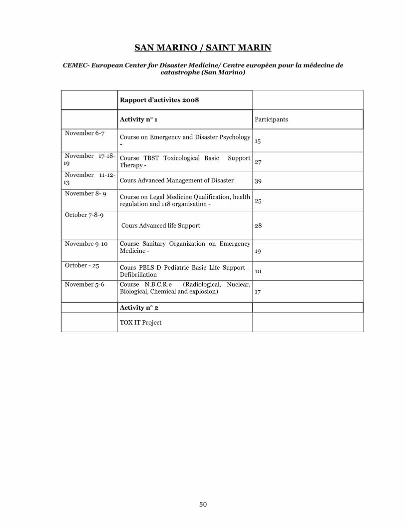
50
SAN MARINO / SAINT MARIN CEMEC- European Center for Disaster Medicine/ Centre européen pour la médecine de
catastrophe (San Marino)
Rapport d’activites 2008
Activity n° 1 Participants
November 6-7 Course on Emergency and Disaster Psychology -
15
November 17-18-19
Course TBST Toxicological Basic Support Therapy -
27
November 11-12-13 Cours Advanced Management of Disaster 39
November 8- 9 Course on Legal Medicine Qualification, health regulation and 118 organisation -
25
October 7-8-9
Cours Advanced life Support 28
Novembre 9-10 Course Sanitary Organization on Emergency Medicine -
19
October - 25 Cours PBLS-D Pediatric Basic Life Support - Defibrillation-
10
November 5-6 Course N.B.C.R.e (Radiological, Nuclear, Biological, Chemical and explosion)
17
Activity n° 2
TOX IT Project
51
TURKEY / TURQUIE
AFEM - European Natural Disasters Training Centre / Centre Européen de Formation sur les Risques Naturels (Ankara)
1. COURSES CARRIED OUT WITHIN THE SCOPE OF INTERNATIONAL ACTIVITIES: "PREVENTION AND EFFECT REDUCTION OF METEOROLOGICAL NATURAL DISASTERS BY THE REMOTE SENSING METHODS” An international course was organized with respect to “Prevention and effect reduction of meteorological natural disasters by the remote sensing methods” in conjunction with General Directorate of Disaster Affairs, Europe Natural Disasters Training Center, in Alanya WMO Regional Meteorology Training Center between the dates of 2nd-6th June 2008. 18 trainees from 14 countries which are Bosnia-Herzegovina, Qatar, Hungary, Morocco, Indonesia, Moldavia, Bulgaria, Romania, Bahama, Sudan, Uganda, Azerbaijan, Egypt and Turkey (AFEM and DMI) and as the trainers, Dr. Cynthia K. Mueller (USA National Center for Atmospheric Research) and Erdem Erdi, Aynur Bozoglu, Dr. Ahmet Emre Tekeli, Dr. Kurtulus Ozturk, Dr. Ibrahim Sonmez, Cuneyt Gecer from General Directorate of State Meteorology Affairs participated in this course carried out in English. Purpose of the course is to help the development of national and regional capacity regarding the management of meteorological disaster by learning how to use the remote sensing methods with respect to the prevention and effect reduction of meteorological natural disasters. Applications of the principal bases of remote sensing, plank functions, infrared, thermal sensitivity, meteorological satellites, remote sensing by meteorological satellites, channel 3.9 and its uses in meteorology and interpretations, interpretation of WV channels, interpretation of window channels, high resolution of visible channels, and precipitation forecasts from satellites, Geo-stationary channels of meteorological satellites and Hydro program were performed. Furthermore, the application of forecasts of radar and satellite, weather forecasts, radar methods and applications, transmission weather forecast and radar methods, forecast of mobile storms, precipitation forecast and data, techniques of wind finding and interpretation of radar images were also performed. “STRONG WEATHER EVENTS AFFECTING AIR TRANSPORT; THEIR FORECAST AND EFFECTS ON FLYING SAFETY” An international course was organized in conjunction with General Directorate of Disaster Affairs, European Natural Disasters Training Center - AFEM, in Alanya WMO Regional Meteorology Training Center between the dates of 9th -13th June 2008. 24 trainees from 18 countries (Lithuania, Estonia, Serbia, Morocco, Azerbaijan, Bosnia-Herzegovina, FYROM, Romania, Turkey, Russia, Kazakhstan, Caribbean Islands, Barbados, Bahamas, Sudan, China, Libya) participated to this course in English. Its purpose was to learn what methods should be used and what measures should be taken in order that the strong weather events will not turn into a disaster and to prevent the aviation accidents arising from the meteorological events, by giving information on how to maintain the flying safety by forecasting such events affecting the air transport. Haci Murat PULLA (General Directorate of State Meteorology Affairs-Aviation Meteorology Branch Manager) made an introductory presentation about General Directorate of State Meteorology of Turkey and gave information on the works carried out in Turkey. Faruk IPEK (Aviation Meteorology Branch Office) made a presentation about the aviation meteorology. Dr. Herbert PUEMPEL (Chief of Aviation Meteorology Department, WMO) gave detailed information on the Aviation Meteorology, flight planning, procedure of decision on the route to be held considering the meteorological conditions, laws, meteorological hazards on the route, SIGWX (Significant Weather Forecast Charts), icing arisen during flight (in the air), identification of condensation, Jet aircrafts, algorithmic forecasts, forecast of over-refrigerated water drops (for icing) (there may sometimes be over-refrigerated in -10/-20 degrees but not frozen water drops in the atmosphere.), present condition-based meteorological warnings, frozen drops, start of drizzle within the stratiform-type clouds, icing within the convective clouds, role of the characteristics of air mass, phase change temperature, turbulence, the connection between wind shear (the change arisen in the velocity or direction or both between two specific points) and turbulence, the volute seen throughout Subtropical Jet (the wind blowing in the locations relatively near the tropics), the volute seen throughout mid-latitude fronts (front= confrontation fields of two separate air masses, there are three
52
types of front: warm, cold and occluded), anticyclonic circulation (clockwise high pressure circulation), summary of very strong turbulence, gravity waves triggered by outward flows arisen as a result of convective movements, turbulence arisen from orographic structures, mountain waves and their determination, significance of the messages containing significant meteorological information and transmitted by the meteorological observation offices, changes to Air Traffic Management, preparation for the change to the code system and wide information system, cooperation with Regional Meteorological Services. Dr. Aurora BELL (Romania National Meteorology Administration) gave detailed information on the CG lightning components, storms and their start, forecast of storms, storm characteristics, very short-tem forecast science for storms, observational methods, convergent flows, new formation arisen immediately behind the squall line, Lightning Meteorology, components used in the forecast (radar, satellite, digital outcome), shallow (fair weather) cumulus cloud, Towering cumulus cloud (TCU), Mature cumulonimbus cloud, dispersing cumulus cloud, electrical activity of multi-cellular cumulative clouds, cloud electrification, convection classification and cognitive models: significant storms detected by radar, Frequency of strong storms, Reflection sample (in the detection of Meteorological events by radar), arc-shaped reflection, inward flow jet elevated on backside, MARC (middle atmosphere responses to change), support of vortex structures, Clockwise circulation (High pressure indicator anticyclone), Counterclockwise circulation (Low pressure indicator cyclone), significant weather, indications of significant storms, general upward flows, a strong indicators of segmented environment. Thomas SEILER (Lufthansa airlines training pilot) gave detailed information on the Downburst (the downward collapses arising from Cumulonimbus cloud, strong down ward flow of wind), identification, structure and three dimensional shape of downburst, laboratory experiences, classification of micro-burst (downbursts with an impact area less than 4 km-small area, big impact) and macro-burst (downbursts with an impact area more than 4 km-big area, small impact), downdraft (Downward flows-wind flow), cooling as a result of mechanism-evaporation (cooling and condensation arisen as a result of inlet of dry and warm air to cloud), its effect on flights and potential hazards, case study on the hazard, downburst analysis and forecast from the point of a pilot, experimental outcomes from GOES (meteorological satellite), airport warnings, meteorological effects on the flying safety, icing effect on the aircrafts, turbulence intensity regarding the classification of aircrafts, turbulence due to the mountain waves and any circulation forces arisen after any circulating or breaking effect (not the windward in mountain waves, the effect dangerous for the aircrafts), direct meteorological effects on the flying safety. 2. SEMINARS ORGANIZED WITHIN THE SCOPE OF IN-SERVICE TRAININGS A. NATURAL DISASTERS TRAINING SEMINAR OF THE MUNICIPALITY OF KECIOREN The seminar for the technical staff of the Municipality of Kecioren was held on the date of 7th March 2008 at the General Directorate of Disaster Affairs. The seminar was aimed at giving information about what the functions of local governances are before, during and after natural disasters and what kind of duties and responsibilities the technical staff of the municipality have in their fields and the attention was paid to the important issues on the implementation of reconstruction plans and the new earthquake regulation prepared by our Ministry. The expected participation to the seminar was ensured, highly favorable information exchange was ensured between the technical staff of the Municipality of Kecioren and the trainers and an efficient working environment was created. The current problems in the implementations related to the subjects were discussed in the question-answer sections during the seminar. The requirements for the training activities that might be carried out later were identified and new ideas were suggested. Furthermore, a photograph exhibition reflecting the works carried out by our General Directorate after the Marmara Earthquake remained open to visit during the seminar at the Municipality Building. B. TRAINING SEMINAR ON AVALANCHE AND NATURAL DISASTERS The seminar organized by the European Natural Disasters Training Center (AFEM) and the Avalanche Research-Development, Reconnaissance and Prevention Branch (CAGEM) for the technical staff in the Directorates of Public Works was held in Elazig, Trabzon, Van and Erzurum . ELAZIG, 10th-11th MARCH 2008 Directors of departments from other institutions in this regard, the heads and from the Special Provincial Administration, the Provincial Gendarmerie Command, the Provincial Directorate of Civil Defence and Firat University as well as the staff from the Provincial Directorates of Public Works
53
participated to this seminar held in the Conference Hall of the Provincial Directorate of Agriculture of Elazig. 84 trainees from 7 provinces (Elazig, Malatya, Diyarbakir, Adiyaman, Bingol, Tunceli and Batman) participated in the seminar. In the first day of the seminar, Mete ERENGIL and Demet SAHIN (CAGEM) made presentations to the participants on the subjects specified in the seminar programme with regard to the avalanche disaster. The final presentation of the first day was made by Sevim OZSAN (AFEM) and AFEM was introduced to the participants. Furthermore, a presentation was made on other natural disasters and harm reduction by giving information about the training activities and projects carried out so far. In the second day of the seminar, the snow and temperature profiling work was practically performed by visiting Hazarbaba Skiing Center together with a crowded group of trainees. The seminar was viewed by the concerned institutions and the common public by being paid great attention and given place in the visual and written media. TRABZON, 10th-11th MARCH 2008 This seminar held in the Meeting Hall of the Trabzon 10th Regional Directorate of Highways. Totally had 56 participants from 7 provinces (Trabzon, Artvin, Giresun, Ordu, Rize, Samsun and Sinop). The presentations on the General Definitions regarding avalanche, Formation Criteria, Types and Effects of Avalanche, Course of Action in the Field, Search and Rescue, Escape Techniques, Harm Reduction Works, Mapping, Avalanche Hazard Map, Avalanche Risk Map, Ground Surveys, Forecasting Method and Prevention Works were made by the Certified Hydrogeology Engineer Omer Murat YAVAS and the Geology Engineer Sinan DEMIR from the Avalanche Branch of the Avalanche Research-Development, Reconnaissance and Prevention Branch (CAGEM) of the General Directorate of Disaster Affairs. Moreover, the Certified Environmental Engineer Devrim BAGLA from the European Natural Disasters Training Center (AFEM) Branch of the General Directorate of Disaster Affairs made the information presentation on other natural disasters and damage reduction by giving information about the training activities and projects that had been carried out so far. In the second part of the training, the snow and temperature profiling and interpreting works for the snow cover providing essential data in the estimation of avalanche were practically shown to the participating technical staff by visiting Rize Ikizdere Plateau. VAN, 10th-11th MARCH 2008 The Provincial Directorates of Public Works and Settlement, the General Directorate of Highways, the Regional Directorate of State Hydraulic Works, the Provincial Directorates of Civil Defence, the Search and Rescue Team of Civil Defence, the Provincial Directorates of Environment and Forest, the Special Provincial Administration, the Municipality of Gurpınar, the Municipality of Baskale, the Directorate of Hakkari Vedas Organization, the Directorate of Meteorological Station and the Special Provincial Directorate of Hakkari participated to this seminar held in the VATSO Conference Hall. 96 people from 6 provinces (Van, Hakkari, Sirnak, Siirt, Agri and Igdir) participated in the training. The presentations on the General Definitions regarding avalanche, Formation Criteria, Types and Effects of Avalanche, Course of Action in the Field, Search and Rescue, Escape Techniques, Harm Reduction Works, Mapping, Avalanche Hazard Map, Avalanche Risk Map, Ground Surveys, Forecasting Method and Prevention Works were made by the Geology Engineer Zafer YAZICI and the Geology Engineer Mehmet COSKUN from CAGEM. Moreover, the Certified Geology Engineer Yeliz TEKER from the AFEM made the information presentation on other natural disasters and damage reduction by giving information about the training activities and projects that had been carried out so far. In the second part of the training, the snow and temperature profiling and interpreting works for the snow cover providing essential data in the estimation of avalanche were practically shown to the participating technical staff by visiting Abali Skiing Center. ERZURUM, 13th-14th MARCH 2008 This seminar was held in the Seminar Hall of the Governor’s Office of Erzurum and 65 trainees from 7 provinces (Erzurum, Ardahan, Gumushane, Bayburt, Kars, Erzincan and Mus) participated. The presentations on the General Definitions regarding avalanche, Formation Criteria, Types and Effects of Avalanche, Course of Action in the Field, Search and Rescue, Escape Techniques, Harm Reduction Works, Mapping, Avalanche Hazard Map, Avalanche Risk Map, Ground Surveys, Forecasting Method and Prevention Works were made by the Certified Hydrogeology Engineer Omer Murat YAVAS, the Geology Engineer Sinan DEMIR, the Geology Engineer Zafer YAZICI and the
54
Geology Engineer Mehmet COSKUN from the CAGEM. Moreover, the Certified Geology Engineer Asuman YILMAZ from AFEM made a presentation on other natural disasters and damage reduction by giving information about the training activities and projects that had been carried out so far. In the second part of the training, the snow and temperature profiling and interpreting works for the snow cover providing essential data in the estimation of avalanche were practically shown to the participating technical staff by visiting Palandoken Skiing Center. C. BASIC TRAINING SEMINAR ON DISASTER PREPAREDNESS AND RESPONSE The seminar organized by the European Natural Disasters Training Center (AFEM) and the Turkish Red Crescent was held from 17th to 21st March 2008 at Ankara Gurkent Hotel. Seval GUZELKILINC, Ali Ufuk GUNDUZ, Eylem SAVUR, Serap ARSLAN TOMAS, Kamil KURTUL, Mehtap BAYKAL, Mujdat BOZBEY from the Turkish Red Crescent were the trainers and 26 trainees from the Turkish Red Crescent and the General Directorate participated in the training. During the training, the Turkish Red Crescent-Red Cross action was introduced and trainees were informed about the disaster response system in Turkey and the role and responsibilities of the Turkish Red Crescent in this system by the introduction to the Disaster Response. Information about the emergency planning and needs assessment in disasters was provided and this information was practically implemented by the trainees. Trainees were also informed about the importance of media and public relations in psychosocial support, communication, logistics in disasters and humanitarian aid services. At the end of the training, a practice was made on emergency sheltering and camping management in disasters and the trainees were informed about monitoring, evaluating and reporting. D. SEMINAR ON BASIC FIRST AID The seminar organized by the European Natural Disasters Training Center (AFEM) and the TURKISH RED CRESCENT was held between the dates of 1th-2nd May 2008. 2 experts from the Turkish Red Crescent as trainers and 19 people as trainees from our General Directorate participated in this seminar. The seminar was specially aimed at informing about first aid the staff of our General Directorate working in disaster areas. They were informed about the basic principles of first aid and how to response in different cases in practical. The certificate distribution ceremony of the course organized by the General Manager Mustafa TAYMAZ was participated by our Deputy General Managers Ali TOKLU, Atamer SEYMEN and Sahin EROGLU; the Head of Planning, Ownership and Indebtment Department Seyfettin AYCICEK and the Head of Machinery Consummation Department Kerem BERBER. E. TRAINING SEMINAR ON NATURAL DISASTERS FOR THE METROPOLITAN MUNICIPALITY OF ANKARA – ASKI The seminar organized for the technical staff of the Metropolitan Municipality of Ankara and Ankara Water and Sewerage Administration was held on the 24th June 2008. The participation of the Assistant Secretary General Omer VURAL from the Metropolitan Municipality of Ankara, the Civil Defence Expert Rifat AKIN from the Metropolitan Municipality of Ankara, the Civil Defence Expert Saadettion EREN from ASKI and 83 people from the technical staff taking charge in ASKI to this seminar was ensured. The seminar was aimed at giving information about what kind of functions the local governances have before, during and after natural disasters and what kind of duties and responsibilities the technical staff of the municipality have in their fields and the attention was paid to the important issues on the implementation of reconstruction plans and the new earthquake regulation prepared by our Ministry. The expected participation to the seminar was ensured, highly favorable information exchange was ensured between the technical staff of the Metropolitan Municipality of Ankara and ASKI and our General Directorate and an efficient working environment was created. The current problems in the implementations related to the subjects were discussed in the question-answer sections during the seminar. The requirements for the training activities that might be carried out later on were determined and new ideas were suggested on these issues. F. TRAINING SEMINAR ON BASIC CIVIL DEFENCE The seminar on “Basic Civil Defence” organized by the European Natural Disasters Training Center (AFEM) for the staff of our General Directorate was held in two groups : one between the dates of
55
3rd-14th November 2008 and the other between the dates of 17th-28th November 2008. This training was given by the instructors of the Civil Defence College of the General Directorate of Civil Defence in the AFEM Meeting Hall of our General Directorate. During the seminar, the basic principles of Civil Defence, the issues to be known and the considerations to be paid attention by a good civil defender were specified by the instructors of the Civil Defence College. The course programme was carried on theoretically and practically. After the theoretical trainings on the subjects stated in the course programme were given by the trainers, the trainees were taken to the Civil Defence College in the 8th day of the course, the fire drill was performed through the introduction and use of rescue vehicle and equipment and the trainees used rescue equipment and fire extinguishers. In the 9th day of the training, the practical implementations used in rescue and the techniques for sanitary transport with stretcher were practically shown. In the last day of the training, the rescue methods and exercise from the upper floors were performed in the Civil Defence College and then the earthquake exercise was performed in the earthquake simulation. In the last day, after the Civil Defence College, the trainees were taken to the Kalealti Shelter which is under the supervision of Governorship and located under the Ankara Castle, they were instructed herein and they carried out investigations. This shelter was built up by the German colonies for the armed forces quarters and governance to work in safety during the Second World War; afterwards it was turned over the Governorship of Ankara in order to be used for civil defence purposes according to the National Security Council’s decision dated 15th January 1964 no 29. The shelter’s area of usage is 1200 m², its capacity is for 3600 people for short-term and 1200 people for long-term. Our trainees were instructed by the trainers of the Civil Defence College on the Basic Principles of Civil Defence, the given information was followed by our trainees by being paid great attention. Moreover, it was ensured for the given information to be permanent by means of the exercises and practices performed. It is considered for the course which is beneficial for the staff of our institution to be extended to all our staff according to the demand. G. SEMINAR ON THE EAST ANATOLIAN FAULT SEISMICITY AND DISASTER WORKS The workshop held in Kahramanmaras from 19th to 21st November 2008 invited the Provincial Directors of Public Works and Settlement, the Branch Managers of Reconstruction and technical staff performing works on these subjects from provinces under the influence of the East Anatolian Fault (Kahramanmaras, Elazig, Malatya, Hatay, Adana, Gaziantep, Bingol, Adiyaman, Mus and Tunceli). The opening of the workshop was attended by Minister Faruk Nafiz OZAK, the Undersecretary Sabri Ozkan ERBAKAN and the Deputy Undersecretary Sadik YAMAC. Non-governmental organizations, municipalities and other local institutions also participated. Certified Geology Engineer Ramazan DEMIRTAS gave detailed information about the active faults causing earthquake in the East Anatolian Fault and the earthquake sensitiveness of the region. He explained the works they carried out in the region. Earthquake Engineering Branch Manager – Certified Civil Engineer Cahit KOCAMAN gave information about the quality of existing building stocks in our country and attracted attention to the mistakes made during the construction of buildings and the damages caused by them and besides he mentioned about the reinforcement works required to be performed especially in the earthquake sensitive regions. Moreover, he clarified the issues amended in “the Earthquake Regulation” renewed in 2007. Afterwards, Dr. Nehir VAROL gave information about the harm reduction works carried out by our General Directorate against disaster. The final presentation made by the Certified Geology Engineer Mehmet Emin DURGUN gave information about disaster sensitive reconstruction plans and how to create micro-zoning and integrated hazard risk maps. In the second day of the workshop, Geology Engineer Bahattin Murat DEMIR and Hydrology Engineer Demet SAHIN gave general information on landslide, rock fall, flood and avalanche disasters and then mentioned about the effects of these disasters in the cities in the East Anatolian fault zone and the works executed by our General Directorate in these regions. The final presentation of the second session made by Certified Agricultural Engineer Senay OZDEN gave information about the global warming which has recently intensely taken place on the agenda and its effects on the Eastern-Southeastern Anatolia Regions. The first presentation of the third session made by Civil Engineer Emel DEMIROK gave information about how to carry out post-disaster damage assessment works and how to fill in the damage assessment forms. She mentioned the works on this issue within the scope of ABIS (Disaster Information System) Project of our General Directorate. Afterwards, the Indebtment Branch Manager Ismail KAYA instructed the participants about ownership works after disaster, assessment of remaining housings and how to organize the annual budget and programme. The information on site selection to be carried out after ownership was presented by Geology Engineer Ayla KIZILTUG. In
56
this presentation, the provisions in the Circular dated 01.08.2008 no 3547 regulating the site selection procedures of new settlement were clarified and the information was given about the site selection procedures of new settlement, preparation of site selection protocols and site selection commission. The mapping, planning, cadastre and expropriation works executed together with the site selection were presented by the Mapping, Cadastre and Expropriation Branch Manager Sedat AYHAN. In this presentation, the provisions in the Expropriation Law no 2942 were clarified and the information was given about the field assignment and assessment of remaining lands. In the third day, participants were instructed about how to structure disaster management and what the stages of disaster management are. The presentation on this issue was made by the Emergency Aid and Coordination Branch Manager Turan ERKOC. Afterwards, participants were instructed by the Geology Engineer Bulent OKAY about the expenditure procedures of emergency aid subsidy. The final presentation of the workshop was made by the Coordinator of Settlement Services Mehmet Ali NAKIBOGLU and the participants were instructed about the settlement of the disaster victims and the implementation of settlement law. At every stage of the workshop, the questions asked by the participants were answered by our expert staff and it was aimed at resolving the most encountered problems in the implementations. The participants expressed that these subjects presented were very useful for them and it was mentioned that the necessity and continuity of such trainings within the institution would be ensured. Furthermore, the information exchange was ensured between the expert staff of our General Directorate and the staff working in the Provincial Directorates with respect to various issues. During our workshop, source books from which the participants would be able to make benefit and CDs including the presentations were distributed to the participants. The workshop was paid above and beyond attention. At the end of the training, training request forms and training satisfaction polls were distributed to all provinces and the objectives of AFEM for the training programme of 2009 were determined according to the provinces. H. DISASTER TRAINING SEMINAR OF THE GENERAL DIRECTORATE OF TECHNICAL RESEARCH AND IMPLEMENTATION The disaster training requested by the Civil Defence Specialty of the General Directorate of Technical Research and Implementation of our Ministry for their own staff was organized in the Conference Hall of the General Directorate of Technical Research and Implementation on the 25th November 2008. The first presentation in the seminar was made by Certified Geology Engineer Dr. Ramazan DEMIRTAS who instructed participants about the seismicity and active faults causing earthquake in Turkey in general and Ankara and its surroundings in private. During the seminar, information was given about the North Anatolian Fault, active faults and seismicity of the Middle Anatolian Plain regime, m > 2.0 earthquakes in Ankara in the last 10 years, seismic gaps and faults with higher possibility of earthquake in our country. The second presentation made by Geology Engineer Sabri SEVIM from the Disaster Reconnaissance and Damage Assessment Department addressed issues such as the definition of disaster, types of disaster, definition of landslide, factors causing landslide, characteristics of landslide, harm reduction in landslide disasters, definition of flood, factors causing flood, characteristics of flood, harm reduction in flood disasters. The final presentation made by Certified Geology Engineer Asuman YILMAZ (AFEM) who gave information about types of disaster, measures to be taken before, during and after earthquake, landslides, indications of landslide, things to do during and after landslide, effects of climate change and things to do for reducing its effects, flood, things to do before, during and after flood, fires, causes of fires, forest fires and things to do during fire. 3. OTHER TRAINING ACTIVITIES In 2007, “the Project for Disaster Preparedness Research- Training Services in accordance with the Open Partial Agreement on European Mediterranean Disaster Damage Reduction” proposed by DPT and AFEM was accepted and will continue until 2014. Preparations for a project work on Raising Common Public Awareness Against Radiological Risks have been started at international level, whith the support of UNDP and the TESEC centre located in Kiev. Negotiations on the establishment of an regional early warning systems for floods and overflows and training on these issues took place as a result of the contacts between USAID and AFEM. A project meeting to which neighboring countries will attend will be held within the first months of 2009. The Center in Skopje invited 2 of our experts to a 5-day training and workshop on disaster damage assessment after disaster and participation was ensured to this meeting. Also, 3 experts of us will attend the training on Influence of Seismic Disasters on Cultural Heritage at the Centre located in Athens in 2009.
57
4. INTERNATIONAL RISK MANAGEMENT GLOSSARY - MLRMG A risk management glossary has been created within the WIN Project leaded by Prof. Dr. Gertrud GRECIANO. It was agreed that Turkish language will be added to this glossary so far prepared in English, French, German, Spanish and Romanian. The glossary work is being carried on by the following group: Dr. Nehir VAROL (Executive), Lale GUREL (Consultant), Assoc. Prof. Ayfer AKTAS (Marmara University), Emel DEMIROK, Oktay GOKCE, Sevim OZSAN, Kagan OZENER This group held its first meeting during the International Workshop on New Management Mentality in Natural Risks held in Istanbul between the dates of 27-28 October and work will be carried on during 2009 and the project extended according to the themes to be added in future years. 5. TRAINING ACTIVITIES OF AFEM AT ELEMENTARY SCHOOLS IN ANKARA AFEM carried on its training activities beginning from elementary schools for the purpose of raising community awareness against disasters and to mitigate disaster damages. 1060 students from 9 schools were instructed about natural disasters such as earthquake, fire, flood, landslide, rock fall and global warming and the measures to be taken before, during and after these natural disasters. AFEM introductory brochures, brochures concerning climate change and earthquakes, small notepads having mottos about natural disasters on each page for children, student and teacher books on “I am Learning Safe Life” (jointly printed by the Turkish Red Crescent) were distributed and 2 posters printed by AFEM on earthquakes and other natural disasters were posted at schools to sensibilize the students. Content of the trainings: 1- Definition and Types of Disaster 2- Earthquakes • Definition of earthquake, definition and types of faults • Precautions to be taken at home before earthquake ; Precautions required to be taken at school before earthquake • Precautions to be taken during earthquake; Things to do after earthquake 3- Landslides • Definition of Landslide and Rock Fall • Indications of landslide observed in the land • Things to do at the moment of landslide; Things to do after landslide 4- Fires • Definition of burning and fire; Causes of fire • What are the methods and extinguishing substances used in fire fighting? • Precautions required to be taken at homes against fire • Importance and use of Smoke Detector for early warning at the moment of fire • Things to do at the moment of fire 5- Forest Fires • Causes of forest fires • Disadvantages of forest fires on economy, climate and nature • Things to do for the prevention of forest fires 6- Global Climate Change and Floods • What is global climate change? Factors leading climate change. • Things to do against global climate change • What is flood? Things to do during flood 7- Important Phone Numbers • Gendarmerie (156), Police (155), • Fire Brigade (110), Inform Forest Fire (177) • Emergency Service (112) 6. ACTIONS IN THE 1st COMMUNICATION, ART AND FRIENDSHIP FAIR IN CUBUK Between 30th May and 2nd June 2008, the Fair held within the scope of “Contribution to Science, Culture and Education Project” organized by the District Governance of Cubuk and the District Ministry of National Education carried out an effective awareness-raising action for the common public on the stand opened by the General Directorate of Disaster Affairs by reaching all visitors taking part in AFEM with respect to natural disasters and disaster damage reduction. Printed books, posters and brochures to increase disaster sensitiveness were distributed to schools and common public. Deputy Undersecretary Sadik YAMAC, District Governor of Cubuk Meftun DALLI and the Mayor of Cubuk Adem TUGLUCA visited our stand and they were informed about our actions.
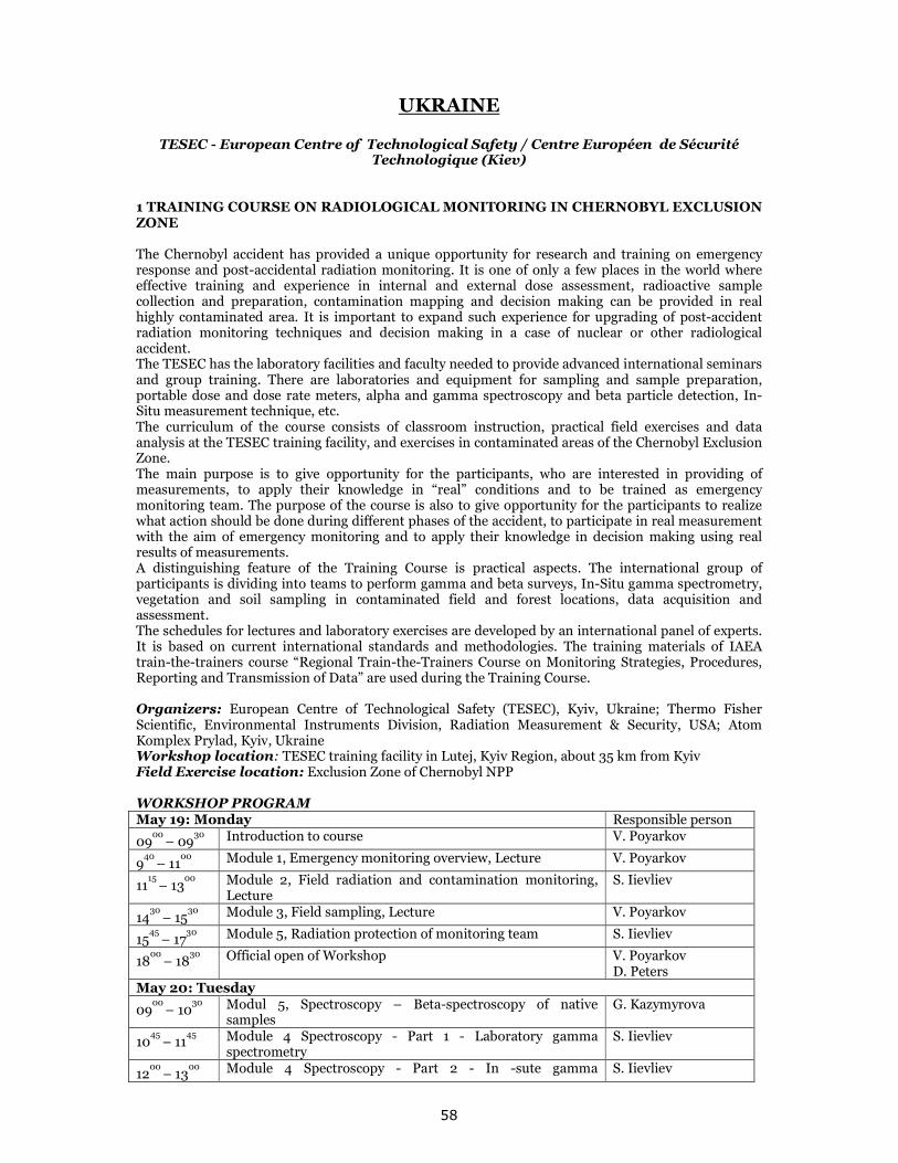
58
UKRAINE
TESEC - European Centre of Technological Safety / Centre Européen de Sécurité Technologique (Kiev)
1 TRAINING COURSE ON RADIOLOGICAL MONITORING IN CHERNOBYL EXCLUSION ZONE The Chernobyl accident has provided a unique opportunity for research and training on emergency response and post-accidental radiation monitoring. It is one of only a few places in the world where effective training and experience in internal and external dose assessment, radioactive sample collection and preparation, contamination mapping and decision making can be provided in real highly contaminated area. It is important to expand such experience for upgrading of post-accident radiation monitoring techniques and decision making in a case of nuclear or other radiological accident. The TESEC has the laboratory facilities and faculty needed to provide advanced international seminars and group training. There are laboratories and equipment for sampling and sample preparation, portable dose and dose rate meters, alpha and gamma spectroscopy and beta particle detection, In-Situ measurement technique, etc. The curriculum of the course consists of classroom instruction, practical field exercises and data analysis at the TESEC training facility, and exercises in contaminated areas of the Chernobyl Exclusion Zone. The main purpose is to give opportunity for the participants, who are interested in providing of measurements, to apply their knowledge in “real” conditions and to be trained as emergency monitoring team. The purpose of the course is also to give opportunity for the participants to realize what action should be done during different phases of the accident, to participate in real measurement with the aim of emergency monitoring and to apply their knowledge in decision making using real results of measurements. A distinguishing feature of the Training Course is practical aspects. The international group of participants is dividing into teams to perform gamma and beta surveys, In-Situ gamma spectrometry, vegetation and soil sampling in contaminated field and forest locations, data acquisition and assessment. The schedules for lectures and laboratory exercises are developed by an international panel of experts. It is based on current international standards and methodologies. The training materials of IAEA train-the-trainers course “Regional Train-the-Trainers Course on Monitoring Strategies, Procedures, Reporting and Transmission of Data” are used during the Training Course. Organizers: European Centre of Technological Safety (TESEC), Kyiv, Ukraine; Thermo Fisher Scientific, Environmental Instruments Division, Radiation Measurement & Security, USA; Atom Komplex Prylad, Kyiv, Ukraine Workshop location: TESEC training facility in Lutej, Kyiv Region, about 35 km from Kyiv Field Exercise location: Exclusion Zone of Chernobyl NPP WORKSHOP PROGRAM May 19: Monday Responsible person
0900 – 09
30 Introduction to сourse V. Poyarkov
940 – 11
00 Module 1, Emergency monitoring overview, Lecture V. Poyarkov
1115 – 13
00 Module 2, Field radiation and contamination monitoring,
Lecture S. Iievliev
1430 – 15
30 Module 3, Field sampling, Lecture V. Poyarkov
1545 – 17
30 Module 5, Radiation protection of monitoring team S. Iievliev
1800 – 18
30 Official open of Workshop V. Poyarkov
D. Peters May 20: Tuesday
0900 – 10
30 Modul 5, Spectroscopy – Beta-spectroscopy of native
samples G. Kazymyrova
1045 – 11
45 Module 4 Spectroscopy - Part 1 - Laboratory gamma
spectrometry S. Iievliev
1200 – 13
00 Module 4 Spectroscopy - Part 2 - In -sute gamma S. Iievliev
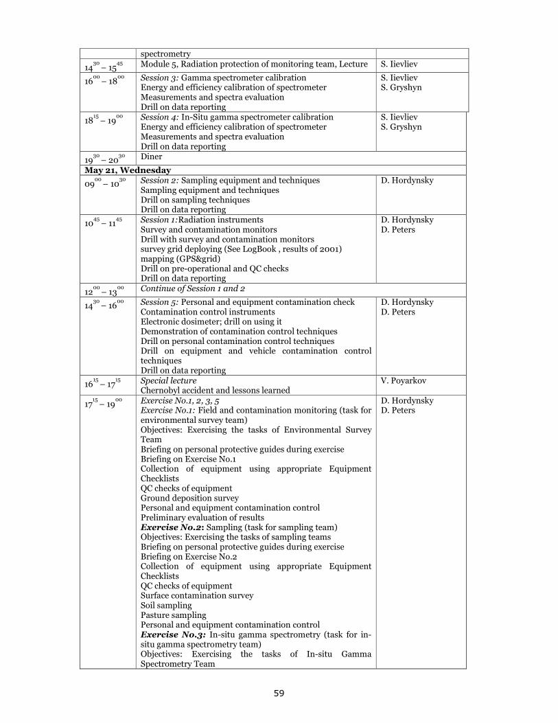
59
spectrometry
1430 – 15
45 Module 5, Radiation protection of monitoring team, Lecture S. Iievliev
1600 – 18
00 Session 3: Gamma spectrometer calibration
Energy and efficiency calibration of spectrometer Measurements and spectra evaluation Drill on data reporting
S. Iievliev S. Gryshyn
1815 – 19
00 Session 4: In-Situ gamma spectrometer calibration
Energy and efficiency calibration of spectrometer Measurements and spectra evaluation Drill on data reporting
S. Iievliev S. Gryshyn
1930 – 20
30 Diner
May 21, Wednesday
0900 – 10
30 Session 2: Sampling equipment and techniques
Sampling equipment and techniques Drill on sampling techniques Drill on data reporting
D. Hordynsky
1045 – 11
45 Session 1:Radiation instruments
Survey and contamination monitors Drill with survey and contamination monitors survey grid deploying (See LogBook , results of 2001) mapping (GPS&grid) Drill on pre-operational and QC checks Drill on data reporting
D. Hordynsky D. Peters
1200 – 13
00 Continue of Session 1 and 2
1430 – 16
00 Session 5: Personal and equipment contamination check
Contamination control instruments Electronic dosimeter; drill on using it Demonstration of contamination control techniques Drill on personal contamination control techniques Drill on equipment and vehicle contamination control techniques Drill on data reporting
D. Hordynsky D. Peters
1615 – 17
15 Special lecture
Chernobyl accident and lessons learned V. Poyarkov
1715 – 19
00 Exercise No.1, 2, 3, 5
Exercise No.1: Field and contamination monitoring (task for environmental survey team) Objectives: Exercising the tasks of Environmental Survey Team Briefing on personal protective guides during exercise Briefing on Exercise No.1 Collection of equipment using appropriate Equipment Checklists QC checks of equipment Ground deposition survey Personal and equipment contamination control Preliminary evaluation of results Exercise No.2: Sampling (task for sampling team) Objectives: Exercising the tasks of sampling teams Briefing on personal protective guides during exercise Briefing on Exercise No.2 Collection of equipment using appropriate Equipment Checklists QC checks of equipment Surface contamination survey Soil sampling Pasture sampling Personal and equipment contamination control Exercise No.3: In-situ gamma spectrometry (task for in-situ gamma spectrometry team) Objectives: Exercising the tasks of In-situ Gamma Spectrometry Team
D. Hordynsky D. Peters
60
Briefing on personal protective guides during exercise Briefing on Exercise No.3 Collecting equipment using appropriate Equipment Checklists QC checks of equipment Measurements with NaI detector in-situ spectrometer Personal and equipment contamination control Evaluation of results Exercise No.5: Personal and equipment contamination check Briefing on personal protective guides during exercise Briefing on Exercise No. 5 Personal contamination check Equipment and vehicle contamination check Data reporting
May 22, Thursday
0745 – 08
15 Collection of equipment, QC checks D. Hordynsky
D. Peters
0815 – 10
00 Departure and travel to the Exclusion Zone; exercise
briefing; changing to personal protective clothing O. Kazymyrov S. Iievliev
1000 – 15
00 Exercise 1, 2, 3 in site of Chornobyl Zone
1500 – 16
00 Visit to Sarcophagus and Prypyat, Changing personal protective clothing , Lanch
1600 – 18
00 Return to TESEC Training Centre
1800 – 19
00 Exercise 5 Personal and equipment contamination check D. Hordynsky
May 23, Friday
0900 – 11
00 Exercise No.4: Laboratory measurements (all teams)
Briefing on Exercise No.4 Sample preparation of collected samples Beta measurements Gamma spectrometry measurements Evaluation of results
S. Iievliev S. Gryshyn
1115 – 13
15 Treatment of In-situ spectrum S. Iievliev
S. Gryshyn
1430 – 16
30 Session 6, Evaluation session
Dose rate and contamination survey results discussion Data Mapping Dose and risk assessment discussion Preparation of Team Leader reports
V. Poyarkov Team members
1645 – 19
00 Team reports presentations, discussion, School summary
and closing V. Poyarkov Team members
2 UPDATING OF TESEC WEB SITE European Centre of Technological Safety (TESEC) is an international research and educational organization created in according to the decision of Founders (the Ministry of Ukraine of Emergencies and Affairs of Population Protection from the Consequences of Chernobyl Catastrophe from Ukraine and Open Partial Agreement from Council of Europe, protocol # 1 of 24.05.97). TESEC acts in according to its Statute, in its activity it is guided by international regulations, decisions of Supreme Soviet of Ukraine, decrees of the President of Ukraine, decisions and orders of Cabinet of Ministers of Ukraine, decisions of Council of Founders of the Centre. The main research area of TESEC is environment protection, emergency prevention, response and relief. TESEC has web site linked with main web site of EUR-OPA major Hazard Agreement. It containing information about TESEC activities and annually updating. 3 PARTICIPATION IN EUR-OPA JOINT PROJECTS AND ACTIVITIES. Participation in the international workshop “For a new governance of natural risks” which took a place on 27-28 October, 2008 in Istanbul (Turkey) Organized by the Council of Europe EUR-OPA Major Hazards jointly with the Turkish Ministry of Public Works and Settlements and the Congress of Local and Regional Authorities of the Council of
61
Europe, the main aim of the Workshop was to encourage public authorities and populations in areas at risk to reinforce their capacity to anticipate and respond to natural disasters. One of the subjects, which have been discussed was Preparedness to Technological Accidents Triggered by Natural Disasters, presented by Victor Poyarkov, European Centre of Technological Safety. A. Introduction The hazardous facilities, which produce and store hazardous materials (like Nuclear Power Plants, storages of toxic materials and waste, establishments where dangerous substances are present in significant quantities), have addition risk of accident and release of hazardous materials to environment as impact of natural disaster. These so-called Natech or na-tech disasters deserve particular attention as they can result in multiple and simultaneous hazardous materials releases. The natural disaster triggered technological disaster (natechs) refers mainly to the impact of a natural hazard on:
• Industrial facilities housing hazardous materials (large, medium and small),
• Hazardous materials storage facilities, including port terminals,
• Gas and oil pipelines,
• Water supply systems,
• Transportation of dangerous goods
• Energy production systems. The different impacts that may be related to different categories of natural events could result in important differences in the damage to chemical or nuclear fixed installations, oil and gas pipelines, electrical power grids, waste treatment, etc.. There are many vulnerable installations close to rivers, or located in earthquake prone areas, or subject to other kinds of natural hazards, thus potentially prone to their impacts. The floods across Europe in the summer of 2002 are an example showing the potential danger of Natech disasters occurring near populated areas. The objectives of presentation are:
• To create awareness of the potential for joint natural and technological disasters (Natechs), by better characterizing the Natech phenomenon in relation to the various hazards on a given territory.
• To better understand the speciality in Natech disaster management.
• To provide an basis where experiences of Natech disaster management could be shared amongst interested parties.
• To identify needs and synergies in the area of Natech disaster management. B. Case studies The storms on December 1999 in France.26 December 1999, at about 02.00, northern half of France (tip of Brittany, Normandy, Ile de France, Champagne Ardennes, Lorraine, Alsace), and storm 2: 27 and 28 December 1999, at about 16.00, southern half of France, in particular, the western and central parts The observed damages on the industrial facilities were as follows:
• Flood in a hydrocarbon deposit in Ambes
• Flood in a hydrocarbon deposit in Bayon-sur-Gironde
• Flood of the thermal power station in Ambes
• Flood in a alcohol production factory, in Ambes
• Flood in a manufacturing plant of fertilizers, in Ambes
• Flood in a plant of carbon black, in Ambes
• Flood in a manufacturing plant of sodium chlorate in Ambes
• Food in surfaces treatment plant, in Muret
• Flood in the nuclear power plant, in Blayais Natech during the Kocaeli Earthquake in Turkey, 1999. The magnitude 7.4 earthquake in Kocaeli, Turkey in August 17, 1999 resulted in over 17,000 deaths and more than 40,000 people injured. Thousands of residential and business units were damaged, and more than 350 industrial facilities in Kocaeli reported damage to their plants. In addition, the earthquake triggered large fires, toxic air releases of dangerous substances and oil spills at several industrial facilities. The earthquake struck a highly urbanized and industrialized region. Kocaeli is one of the most densely populated region in Turkey. Hazmat releases were reported at 14 facilities, eight of these industrial facilities reported substantial hazmat releases with offsite consequences. A total of twenty one hazmat incidents were documented.
62
Examples of hazmat releases include the release of 50,000 kg of crude oil into Izmit Bay, the spill of 100,000 kg of phosphoric acid, and three simultaneous independent fires at an oil refinery (Steinberg and Cruz 2003). Problems with lifeline systems and onsite utilities were also reported. A total loss of electrical power and communications capabilities were reported in all facilities. A dam broke at the Aurul Mine Tailings Recovery Plant near Baia Mare in north-western Romania, 2000. On the night of January 30/31, 2000, in north-western Romania heavy precipitation, about 35,7
l/m2 in 24 hours, and a sudden increase in ambient temperature, which was unusual for this period of
year, results in the melting of a 43 cm thick snow strata that covered a settling pond. The melting of the snow results in an increase in the level of settling pond containing industrial waste waster with high cyanides concentration. Due to these conditions, a breach of about 25 m in the pond’s dam was
produced. Through this break about 100.000 m3 of a high cyanide and heavy metal containing
wastewater were discharged into the receiving creeks, and from there onwards into the river network of the Danube Basin (Somes/Szamos; Tisza and the Danube). The cyanide containing water first reaches the Lapus River and then the Somes River. At the Satu Mare section, a maximum concentration of cyanides of 32,8 mg/l was determined, compared to 0,01 mg/l that represents the maximum permissible limit according to the Romanian standard for surface waters. 2002 flood in Europe. In August 2002 a 100-year flood caused by over a week of continuous heavy rains ravaged Europe, killing dozens, dispossessing thousands, and causing damage of billions of euros in the Czech Republic, Austria, Germany, Slovakia, Poland, Hungary, Romania and Croatia. Prague received significant damage from what were deemed to be the worst floods to hit the capital in 200 years. Among the regions of the capital city most severely affected were: Karlín, Kampa and Holešovice, where there was significant risk of building collapse.. Most of Prague's art work was saved due to advanced warning of high water levels, however there was significant damage to the Prague Metro subway system whose tunnels were completely flooded. In Germany, the flooding was significant in that it destroyed a lot of the work that had been done throughout the country since unification in 1990, especially the town of Grimma in the former East Germany. Dresden received significant damage when the Elbe River reached an all-time high of 8.9 meters. More than 30,000 people were evacuated from various neighborhoods throughout the city and some of the city's cultural landmarks were considered to be at risk. Consequences- large-scale damages of houses, infrastructure (subway, roads, bridges...) Problems of industrial facilities – oil spills, tank floating, chemical release Reference: Analysis of Natech (Natural Hazard Triggering Technological Disasters) Disaster Management NEDIES Workshop Proceedings Ispra, Italy, 20 – 21 October 2003 2007 earthquake in Japan. The July 16, 2007 quake struck 160 miles northwest of Tokyo along Japan's western coast, killing 10 people and injuring more than 1,000. The quake caused doubt on the safety of Japan's 55 nuclear plants, which supply about a third of the nation's electricity. It damaged the Kashiwazaki-Kariwa plant — the world's largest in terms of capacity — causing radioactive leaks and spills, a fire and problems that were compounded by employee error. Plant operator Tokyo Electric Power Co. (TEPCO) has acknowledged the leak and other problems. 315 gallons of radioactive water drained into the Sea of Japan; the contaminated water was 50% more radioactive than first reported; radiation leaked into the air through broken pipes; and the quake overturned 400 barrels containing nuclear waste (up from 100 first reported). "All 55 (Japanese nuclear plants) have this kind of vulnerability," Katsuhiko Ishibashi, a Kobe University seismologist, said. "The best thing is now to shut down all the units and re-examine the potential of this kind of danger." Some plants, he said, would likely never reopen. Japan is not the only country in the world that has built nuclear power plants on or near fault lines. Metsamor Nuclear Power Plant (Armenia) was built during the 1970s, about thirty kilometres west of the Armenian capital of Yerevan and about 15 kilometres from Turkey boundary. The plant was constructed with two VVER-440 Model V230 nuclear reactors, and the technology used at the time is no longer acceptable by modern safety standards. The power plant produces about 40% of Armenia's electricity. It was closed due to the 1988 earthquake in Armenia. Two V-230 reactors each of 407.5 MWe (gross) were built there on solid basalt and supplied power from 1976 and 1980 respectively. Design life was 30 years. These were the first Russian plants designed to be built in a region of high seismicity and were modified accordingly to be designated V-270, giving 376 MWe net. Plans for units 3 & 4 at the site were abandoned after the Chernobyl accident.
63
In December 1988, a powerful earthquake, resulting in the deaths of at least 25,000 people, occurred in northwestern Armenia. The Metsamor nuclear power plant 75 km from the epicentre continued operating normally with no damage, but both units were shopped due to safety concerns regarding seismic vulnerability. Unit 1, after 13 years operation, is now being decommissioned. In 1993 it was decided to restart the second unit due to the severe economic crisis and this was achieved in 1995, after 6.5 years shutdown. Since then the IAEA has been participating in safety improvements at the plant, which is now scheduled to close in 2016. C. Natech disaster management Land-using. One of the basic strategies for preventing and mitigating technological emergencies triggered by natural disasters is the issue of location. The municipalities have to have the overall responsibility for land- use planning. This means that they have to have the responsibility for knowing about the natural conditions (e.g. areas with poor ground-stability, dams and calculated flood areas) in the municipality and responsibility for the location of new buildings. The construction of vulnerable buildings and hazardous installations should be avoided in areas that suffer from natural hazards. Risk mapping is an excellent tool for risk management. It can help in the process of land-use planning and increase awareness and preparedness for emergencies, but also as a tool to take preventive measures. Emergency planning. The special emergency management plans have to be prepared to address elements and issues that were recognised and judged to be potentially dangerous, like:
• critical motorway sections – especially during winter,
• dangerous industrial establishments,
• nuclear power stations,
• pipelines,
• airports,
• mountain railroads,
• train yards,
• floodplains,
• avalanche-prone areas,
• thunderstorm pathways,
• water supply systems,
• hospitals,
• old people’s homes etc. These special plans provide the measures to cope with each particular type of threat, along with the responsible authority that has the mandate to manage it and its potential realisation. Special alerting systems are also included in order to reduce the potential damage. This is the advantage of the special plans, as it provides a lot of information on what to do in case of a particularly dangerous event. It also provides a preparedness strategy, which includes public awareness and educational schemes, along with drill exercises. In USA under the Risk Management Plan (RMP), industrial facilities must prepare a safety management plan to minimize the risk of hazardous material releases affecting nearby (“fence-line”) communities. As part of these provisions, companies must conduct an off-site consequence analysis in which a worst case of hazardous material release is postulated, and the resulting chemical plume is mapped and overlaid with a map of fence- line communities. It also requires off-site worst case analyses of potential chemical releases, but it also explicitly requires consideration of earthquake-caused hazmat releases. Special seismic guidelines provide specific recommendations on seismic design at chemical facilities. D. Conclusion There is a clear need to better understand the relationship between natural and technological hazards and their combined impacts in the short, medium and long term. The activities should be initiating for optimising prevention strategies, level of preparedness, existing mechanisms of response to face natech risks, including methods of information to the public. The wider discussion regarding natech disaster risk management and exchange of experiences have to be starting.