5 Si oui, indiquer l’intitulé du second CE Le projet ...vigny/LIA-MdB/KIDSNAP.pdf · programme...
36
PROGRAMME BLANC EDITION 2010 Projet 20742 DOCUMENT SCIENTIFIQUE 1/36 Acronyme KIDSNAP Titre du projet en français Cinématique et déformation des plaques Amérique du Sud et Nazca Titre du projet en anglais Kinematics and Deformation of South America – Nazca Plates Comité d’Evaluation référence (CE) 1 Projet multidisciplinaire OUI NON Si oui, indiquer l’intitulé du second CE Coopération internationale (si applicable) Le projet propose une coopération internationale avec les Etats-Unis (accord ANR/NSF) autres pays Aide totale demandée 319 176 € Durée du projet 36 mois 1 Indiquer la référence du CE choisi pour l’évaluation du projet (cf. tableaux page 3 et 4 du texte de l’appel à projets)
Transcript of 5 Si oui, indiquer l’intitulé du second CE Le projet ...vigny/LIA-MdB/KIDSNAP.pdf · programme...

PROGRAMME BLANC
EDITION 2010
Projet 20742
DOCUMENT SCIENTIFIQUE
1/36
Acronyme KIDSNAP
Titre du projet en français
Cinématique et déformation des plaques Amérique du Sud et Nazca
Titre du projet en anglais
Kinematics and Deformation of South America – Nazca Plates
Comité d’Evaluation référence (CE)1
Projet multidisciplinaire
OUI NON Si oui, indiquer l’intitulé du second CE
Coopération internationale (si applicable)
Le projet propose une coopération internationale avec les Etats-Unis (accord ANR/NSF) autres pays
Aide totale demandée
319 176 € Durée du projet 36 mois
1 Indiquer la référence du CE choisi pour l’évaluation du projet (cf. tableaux page 3 et 4 du texte de l’appel à projets)
PROGRAMME BLANC
EDITION 2010
Projet 20742
DOCUMENT SCIENTIFIQUE
2/36
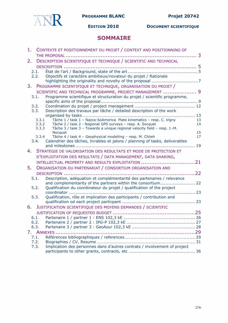
SOMMAIRE 1. CONTEXTE ET POSITIONNEMENT DU PROJET / CONTEXT AND POSITIONNING OF
THE PROPOSAL .............................................................................. 3 2. DESCRIPTION SCIENTIFIQUE ET TECHNIQUE / SCIENTIFIC AND TECHNICAL
DESCRIPTION ............................................................................... 5 2.1. État de l'art / Background, state of the art .................................................. 5 2.2. Objectifs et caractère ambitieux/novateur du projet / Rationale
highlighting the originality and novelty of the proposal ................................. 7 3. PROGRAMME SCIENTIFIQUE ET TECHNIQUE, ORGANISATION DU PROJET /
SCIENTIFIC AND TECHNICAL PROGRAMME, PROJECT MANAGEMENT .................... 9 3.1. Programme scientifique et structuration du projet / scientific programme,
specific aims of the proposal ..................................................................... 9 3.2. Coordination du projet / project management ........................................... 12 3.3. Description des travaux par tâche / detailed description of the work
organised by tasks ................................................................................ 13 3.3.1 Tâche 1 / task 1 – Nazca-SoAmerica Plate kinematics – resp. C. Vigny 13 3.3.2 Tâche 2 / task 2 - Regional GPS surveys – resp. A. Socquet 14 3.3.3 Tâche 3 / task 3 – Towards a unique regional velocity field – resp. J.-M.
Nocquet 15 3.3.4 Tâche 4 / task 4 – Geophysical modelling – resp. M. Chlieh 17
3.4. Calendrier des tâches, livrables et jalons / planning of tasks, deliverables and milestones ..................................................................................... 19
4. STRATEGIE DE VALORISATION DES RESULTATS ET MODE DE PROTECTION ET
D’EXPLOITATION DES RESULTATS / DATA MANAGEMENT, DATA SHARING, INTELLECTUAL PROPERTY AND RESULTS EXPLOITATION ................................21
5. ORGANISATION DU PARTENARIAT / CONSORTIUM ORGANISATION AND
DESCRIPTION ..............................................................................22 5.1. Description, adéquation et complémentarité des partenaires / relevance
and complementarity of the partners within the consortium......................... 22 5.2. Qualification du coordinateur du projet / qualification of the project
coordinator .......................................................................................... 23 5.3. Qualification, rôle et implication des participants / contribution and
qualification od each project particpant .................................................... 23 6. JUSTIFICATION SCIENTIFIQUE DES MOYENS DEMANDES / SCIENTIFIC
JUSTIFICATION OF REQUESTED BUDGET .................................................25 6.1. Partenaire 1 / partner 1 : ENS 102,3 kE ................................................... 26 6.2. Partenaire 2 / partner 2 : IPG-P 102,3 kE ................................................. 27 6.3. Partenaire 3 / partner 3 : GeoAzur 102,3 kE ............................................. 28
7. ANNEXES ...................................................................................29 7.1. Références bibliographiques / references .................................................. 29 7.2. Biographies / CV, Resume ...................................................................... 31 7.3. Implication des personnes dans d’autres contrats / involvement of project
participants to other grants, contracts, etc …............................................. 36
PROGRAMME BLANC
EDITION 2010
Projet 20742
DOCUMENT SCIENTIFIQUE
3/36
1. CONTEXTE ET POSITIONNEMENT DU PROJET / CONTEXT AND
POSITIONNING OF THE PROPOSAL Spatial Geodesy techniques now enable us to monitor the Earth’ surface motion with an accuracy better than 1 mm/yr in a global reference frame. Over the last two decades, GPS has been widely used to determine the kinematics of plate and quantify the surface deformation along their boundaries, shedding new light on the processes driving the deformation of the crust of the lithosphere. In south America, rapid subduction of the oceanic Nazca plate beneath the South American continent induces two different processes: (1) because frictional properties prevent free slip along part the subduction interface (at least at shallow depths), elastic stress accumulates, which is released intermittently through large earthquakes, with an average of one moment magnitude Mw~8.0 event every ten years and at least one Mw>8.7 per century. During the XXth century, two of the five largest earthquakes in the world occurred along the Nazca/South America subduction. First, the largest earthquake ever recorded instrumentally, the May 22 1960 Valdivia earthquake of magnitude Mw=9.5, occurred along the Chilean part of the subduction zone and generated a giant trans-Pacific tsunami that caused catastrophic damage along the coasts of Hawaï and Japan. Second, the 1906 Mw 8.8 northern Ecuador-Southern Colombia ruptured about 500 km of the subduction interface (Kanamori & McNally, 1982). (2) permanent deformation occurs over an 500-1000 km wide area, contributing to build and maintain of the high topography of the Andean Cordillera and thrusting over the south American continent. The deformed area includes all Chile, penetrating deep into Argentina, in the southern Andes, Bolivia, Peru in the central Andes, Ecuador and Colombia. Over the past decade, several projects have developed GPS measurements in order to better quantify the stress accumulation along the subduction interface and the permanent deformation across and aside the Andes. However, they were all confronted to the same problems, still unsolved today: 1. The motion of the Nazca plate is difficult to determine accurately because of the plate is oceanic with very few emerged grounds. Today, its present day motion is defined by the absolute minimum required (2 stations in Galapagos and Easter Islands). Uncertainties on these vectors inevitably lead to a poorly constrained rigid rotation vector estimate of the plate. Discrepancies among model predictions of the Nazca/South America convergence rate reach ~5 mm/yr in southern Chile. 2. In contrast to Europe or Northern America, the CGPS sampling over the South American continent remained very sparse until very recently and efforts by Brazil and Argentina to develop such networks since 2007-2008. Therefore, how far deformation penetrates inland the South America continent is still poorly quantified at many places. Thus, it is still not completely clear if it is correct to use the Brazilian craton as a reference for modelling the elastic coupling along the subduction. 3. The possibility of an intermediate “sliver”, a third block between Nazca and South-America, has been evoked in the literature. While the existence of a micro-plate is well documented (at least from tectonic studies) for the northern Andes (Pennington, 1981), geodetic estimates of the motion of such a block is highly speculative, since it is precisely within the uncertainties of the first two. Therefore, even its existence cannot be stated with certainty. Moreover, large earthquake have occurred in the Cordillera, indicating significant strain occurs within in the Andes, including extension like in the Cordillera Blanca in central-northern Peru. These three unknowns yield a clear impact on the estimation of the amount of coupling on the subduction, the existence of continental faults within and at the sides of the Andes, and the amount of finite deformation taken on the seismic cycle to build the mountain ranges: i.e. how much of the deformation is not occurring on the subduction and will not contribute to earthquakes there, but possibly elsewhere. In order to solve these problems we simply propose to install CGPS stations at strategic places: - On Nazca Islands, closer to the subduction than Galapagos or Easter Island, namely: Juan
Fernandez & San Felix (Chile), easternmost island of the Galapagos (San Cristobal) and Malpelo
PROGRAMME BLANC
EDITION 2010
Projet 20742
DOCUMENT SCIENTIFIQUE
4/36
(Colombia) - Inland the South-American continent, within a stripe parallel to the trench but on the eastern side
of the Andes, which might (or not) be deforming at a few mm/y relative to the brazilian craton (Bolivia, Argentina, Peru, Ecuador).
Adding new permanent geodetic sites will benefit to the whole geodetic community. The global GNSS tracking network in the Pacific is very sparse. We plan to install GNSS (GPS, Glonass and Galileo ready) receiver, with satellite communication so that our data will contribute to the global tracking network of the IGS, and help global geodetic studies. We will also carry out campaign style measurements, on distinct profiles in the 3 countries in order to make the measurements denser between the cGPS stations. This project builds upon distinct regional projects (in Chile, Peru and Ecuador), in which French scientists, and among them geodesists, are deeply involved, some of these projects having been funded by the ANR. - Under the framework of the project SubChile 1 & 2 (PI C. Vigny and J.P. Vilotte, grants ANR-05-
CATT-014 and ANR-06-CATT-010), we developed a network of 30 cGPS stations in central and northern Chile. Campaign style networks were also developed and measured.
- Specific post-seismic interventions were conducted in northern Chile after the Tocopilla earthquake of September 2007. These were funded by specific INSU grants and IPGP funding.
- The whole Franco-Chilean cooperation is operated under a specific umbrella, the International Associate Laboratory (LIA) “Montessus de Ballore”, MOU signed between French CNRS and Chilean University of Chile at Santiago.
- Under the frame of the project ADN (PI Jean-Mathieu Nocquet, grant ANR-07-BLAN-0143-01), a network of 45 GPS campaign sites and 5 CGPS was in installed in northern Peru and first observed in 2008. About 10 CGPS/Broad Band seismometer/accelerometers stations have been installed in 2008 and 40 campaign sites were remeasured in Ecuador in 2009.
We want to take advantage of these existing projects and build upon them to:
- create a common reference frame (in geodetic sense) for all the regional studies - build a common GPS data & processing center - generate a combined solution at the scale of the two plates - build a broader comprehension of the large scale tectonic context in which the
subduction takes place. Finally, by providing a better constrain on the kinematics of the Nazca plate, defining strain rates across the Andes and quantifying the deformation across the sub-andean thrust will impact any regional study along the plate boundary. It will reduce the uncertainty in the coupling coefficient estimate, improving the seismic potential assessment of each segment of the subduction zone. It will contribute to assess the seismic hazard within and east of the Cordillere, in area that are usually populated and of vital economic interest for the Andean countries.
PROGRAMME BLANC
EDITION 2010
Projet 20742
DOCUMENT SCIENTIFIQUE
5/36
2. DESCRIPTION SCIENTIFIQUE ET TECHNIQUE / SCIENTIFIC AND
TECHNICAL DESCRIPTION
2.1. ÉTAT DE L'ART / BACKGROUND, STATE OF THE ART
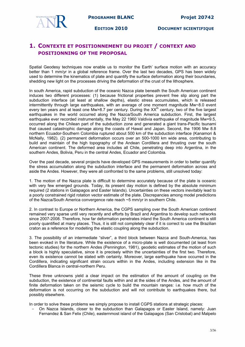
Nazca plate kinematics While an early geodetic work from Larson et al., 1997 found similar rates, most recent studies (eg: Norabuena et al, 1998; Norabuena et al, 1999; Angermann, et al., 1999; Kendrick et al, 2003; Vigny et al, 2009) concluded that the present-day motion of the Nazca plate with respect to South America is ~15% slower than its Nuvel-1A estimate which averages motion over the last 3.16 Ma. The velocity reduction is also confirmed by long-term (40 m.y.) reconstructions of Nazca (Farallon)–South America plate motion (Somoza, 1998). Iaffaldano et al. (2006) recently proposed that the topographic load induced by the growth of the Andes consumes a significant amount of the driving force available for plate tectonics by increasing frictional forces between downgoing and overriding plates, then causing the convergence rate. This velocity decrease has the important consequence that along the South American margin, instead of nearing 8 cm/yr, today’s Nazca/South America rate ranges from 5.5 cm/yr in Equator to 7 cm/yr in central Chile, decreasing again to 6.5 cm/yr in southern Chile (figure 1). However, as stated in section 1, our knowledge of the present-day Nazca kinematics relies on two permanent geodetic sites located in on Easter Island and an island of the Galapagos archipelago. Despite benefitting from cGPS (EISL & ISPA), Satellite Laser Ranging (site 7097), and DORIS (easa) measurements, there are discrepancies reaching 2 mm/yr within the current global realization of the ITRF2005 (Altamimi et al., 2007) and reaching 5 mm/yr at some sites within the weekly updated IGS cumulative solution. Such uncertainty directly leaks into any Nazca rotation rate vector estimate. The site in the Galapagos archipelago is located on the Santa Cruz island. Although most volcanic activity is concentrated in the westernmost islands (Isabella & San Fernandina islands), any deformation induced by volcanic magma chamber on the GALA & GLPS sites located only 40 km east of Isabella island cannot be ruled out. Further more, Kendrick et al. (2003), using additional campaign sites in Robinson Crusoe Island and San Felix islands concluded that EISL had a 6-7 mm/yr residual velocity with respect to all the other sites. Their conclusion is however based on only two epochs of measurements. Finally, Trenkamp et al. (2003) published a velocity estimate for a site located on the Malpelo island, off-shore of Colombia. This site shows a 5 mm/yr residual velocity with respect to the Kendrick et al. (2003) Euler pole prediction for this site. How all these uncertainties are impacting the Nazca/South America convergence rate and prediction still remains uncertain. As stated by Vigny et al. (2009) and Kendrick et al. (2003), including the Easter island vectors in the estimation of the Nazca plate motion mainly induces a difference of 5 mm/yr in southern Chile. However, larger bias cannot be excluded.
Fig 1. Nazca/South America relative motion and today’s rate of subduction as measured by GPS.
PROGRAMME BLANC
EDITION 2010
Projet 20742
DOCUMENT SCIENTIFIQUE
6/36
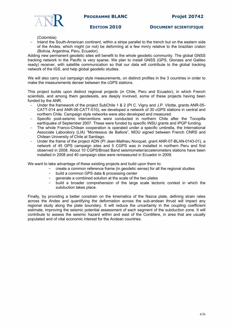
Two versus three-plate models How this convergence is taken up along the South America margin has still to be clearly documented and understood. Because of friction properties preventing free slip along the subduction interface (at least at shallow depths), elastic stress accumulates during decades or centuries. This deformation eventually is released through large earthquakes occurring along the Andean margin. It is however not clear whether the stress accumulation occurs along all segments of the Andean subduction. For instance, no large earthquake has been reported since the arrival of Spanish conquistadores along the segment running from about 100 km north of Lima (Peru) to the north of the Guayaquil gulf in central Ecuador, a question addressed by the ADN project whose data will be included in this proposal. However, where measurements have been carried out, the velocity field always shows a pattern of motion towards the land decreasing as a function of the distance to the trench. Up to now, two end-members model have been proposed to explain the observed geodetic field. We illustrate their main differences for the Chilean segment of the Andean subduction. Based on campaign measurements over a network of hundreds of geodetic benchmarks spanning the whole continent (SAGA), Klotz and co-authors (Klotz et al., 2001; Khazaradze et al., 2003) use a 2-plate (Nazca and South America) model, and explain the observed velocity field as entirely being induced by the elastic locking along the subduction interface. Alternatively, Kendrick and co-authors (Kendrick et al., 2003; Brooks et al, 2003) using a comprehensive network of benchmarks (CAP), propose that the Andes behaves a micro-plate distinct from South America, moving eastward and underthrusting stable south America, east of the Andes. This discussion is strongly linked to the estimate of the Nazca plate kinematics. Because, Kendrick et al.’s Euler pole predicts convergence rate 5 mm/yr slower than other authors, they re-assign this motion to an Andean rigid block between Nazca and South America (figure 2).
Brooks et al., 2003. Three plates model, where an Andean block is introduced between Nazca and SouthAmerica. This micro-plate would move approximately 5 mm/yr Eastward. Thus, the subduction rate would be 5 mm/yr slower and a second tectonic structure (the boundary between blocks A and S) would accumulate 5 mm/yr of convergence.
Fig 2. Measured velocities (yellow dots between 30°s-33°S, white dots outside) and modeled velocities at 32°S (green and purple lines) based on a 2-plates model (green), or a 3-plates model (purple) The seismic hazards generated by the two models are somehow different: in the first case, it is maximized along the subduction and essentially zero everywhere else; in the second case it is slightly reduced along the subduction, at the cost of generating a new at-risk area on the eastern margin of their Andean block.
PROGRAMME BLANC
EDITION 2010
Projet 20742
DOCUMENT SCIENTIFIQUE
7/36
We attribute this difference to two different reasons: (1) both studies (SAGA and CAP) use very large-scale networks with hundreds of points but with very large spacing (100-200 km) between them, and might have given too much weight to measurements in the far field of the subduction. This is particularly obvious for SAGA, where important residuals (the differences between measured and modelled velocities reach 1.5 cm/yr at many points) show up precisely near the trench, whereas the fit is much better 400 km away from the trench (figure 2, right panel) (2) between 30°S and 33°S, velocities measured in Chile vary by at least 50% (from 3 cm/yr to 2 cm/yr) at a given distance from the trench. The gradient of 5 mm/yr in the Argentinian precordillera is also poorly reproduced: velocities at a given longitude vary between precisely 5 and 10 mm/yr. In this case, a model using a single rigid block motion for the Andes and a constant locking depth for the subduction interface is therefore not able to correctly explain the data. Recent more detailed studies (Ruegg et al., 2009, Vigny et al., 2009) have shown that there is a clear change of trend in the Coquimbo region between 30°S and 32°S, and that this region is itself different from what is expected from the standard elastic modelling that works well further south or further North. Similar discussions exist for the central Andes where the shortening rate across the sub-andean domain impact the coupling estimates and the subduction (Norabuena et al., 1998) or it is used as an evidence for an independent block (Bevis et al., 2001). In Ecuador, the existence of an Andean block moving towards NNE is well documented by active tectonics observation of strike-slip faults running east of the gulf of Guayaquil to Venezuela (Pennington, 1981, Kellog et al., 1985). However, its kinematics and possible internal deformation has yet to be quantified (Trenkamp et al. 2002, White et al., 2003).
2.2. OBJECTIFS ET CARACTÈRE AMBITIEUX/NOVATEUR DU PROJET / RATIONALE HIGHLIGHTING THE ORIGINALITY AND NOVELTY OF THE PROPOSAL
We believe that significant advances can be achieved to better understand the processes driving the deformation along the Andean margin, leading to a better seismic hazard assessment for the Andean countries. First, we will accurately constrain the kinematics of the Nazca plate by installing high quality cGPS stations on the Nazca plate. Given the present day precision of GPS positioning, we believe that determining velocity at a 1-2 mm/yr precision over the 3 years of the project is reasonable. Adding four new CGPS site will reduce the uncertainty by 50%, and more important, will enable us to identify any bias to the poorly constrained models published so far. As a by-product, such data will help to improve the Global Reference Frame realization (ITRF, Altamimi et al., 2007), and the tracking network of new GNSS satellites that will be available in the very near future. Data collected during this project will therefore indirectly contribute to global geodesy and geodynamics studies. Secondly, by installing new permanents and campaign sites crossing the Andes and reaching the stable interior of the South America plate, we will provide the kinematics conditions at the boundary of the Andes deformation system, a result that may significantly impact both geological and geodetic studies of the Andean deformation, and might triggered a re-assessment of results published so far on the seismic potential along the subduction, across the Andes and in the sub-andean domain. An important data constraining possible models are the vertical velocities. In particular, transition from uplift to subsidence enables to determine the down-dip limit of the zone being locked along the subduction interface (with the assumption -to be verified- that all other contributions to vertical motion are small compared to the elastic locking along the subduction interface). GPS vertical component is known to be 2-5 times less accurate than horizontal ones, mainly because of tropospheric effects. Moreover, non-tectonic effects induced by ocean loading, atmosphere and continental hydrology need to be precisely accounted for to extract any tectonic signal. Continuous measurements may be needed to quantify these effects accurately, but highly dense network might be required to pick up narrow zone of high strain rate, a key observation to discriminate among models. Therefore, we need many dense profiles to characterize the deformation. If made uniquely of permanent stations, such dense networks would be extremely costly and difficult to maintain. For this purpose, we advocate a mix of cGPS and campaign style measurements (with fixed height centering systems): the later provides the
PROGRAMME BLANC
EDITION 2010
Projet 20742
DOCUMENT SCIENTIFIQUE
8/36
required spatial resolution while continuous stations interleaved with the markers allow to detect transient motions and seasonal cycles affecting the vertical deformation. Clearly, the 2- or 3-plate models are approximation. Distribution of seismicity, focal mechanism and active faulting indicate that some strain is accommodated across the Cordillera and east of it. The question is then to quantify this deformation and see whether the “sliver” model is a valid approximation and to what extent it can simply explain the available data. Similarly, considering homogenous coupling along the subduction interface is a crude approximation. Recent studies of other subduction zones show that the spatial distribution of locking is highly variable both along strike and in depth (e.g. Bürgmann et al. 2005, Chlieh et al., 2008). We will therefore investigate a wide range of models, that will allow spatially variable coupling along the subduction interface, test of independent rigid or straining Andean domain and laterally variable shortening along the sub-andean thrusts. Our project will significantly improve the seismic hazard assessment along the Andean margin. Correctly determine the kinematics of the Nazca plate will reduce the uncertainty when coupling coefficients are derived. Furthermore, our result will tell the level of strain gradient across the Andes and the shortening rate across the sub-andean thrusts that might be accommodated through crustal earthquakes. Although crustal earthquakes are likely to have magnitudes smaller than large subduction earthquakes, because faults rupture might happen close to populated areas, they still are a potential major threat to large cities like Santiago, Cuzco or Quito. Identifying crustal faults and quantifying their associated slip rate is an important task, even if slip rate can be of the order of a mm per year or less. In this case, GPS measurements carried out during this project may not evidence this small signal, but precise geodetic measurements should start as early as possible anyways to provide the longer time span needed by future studies.
PROGRAMME BLANC
EDITION 2010
Projet 20742
DOCUMENT SCIENTIFIQUE
9/36
3. PROGRAMME SCIENTIFIQUE ET TECHNIQUE, ORGANISATION DU
PROJET / SCIENTIFIC AND TECHNICAL PROGRAMME, PROJECT
MANAGEMENT
3.1. PROGRAMME SCIENTIFIQUE ET STRUCTURATION DU PROJET / SCIENTIFIC PROGRAMME, SPECIFIC AIMS OF THE PROPOSAL
The team All participants to this proposal share capacities in GPS data acquisition, processing and modelling. However, for efficiency, the project is divided into 4 tasks, under the responsibility of only one of us, but we emphasize that we will all work jointly and contribute to all tasks through common field work, joint processing and modelling with continuous exchanges. We are planning to have a work meeting every 3 months over the three years of the project. The proposed tasks are: - Task 1 – Nazca-SoAmerica plate kinematics – resp. C. Vigny - Task 2 – Regional GPS surveys – resp. A. Socquet - Task 3 – Towards a unique velocity field – resp. J.-M. Nocquet - Task4 – Geophysical modelling – resp. M. Chlieh Tasks short description and methodology - Task 1 – Nazca-SoAmerica plate kinematics – resp. C. Vigny This task deals with the installation of new cGPS stations, their maintainance, the collection/archiving/distribution/processing of data. Its objective is to provide a correct estimation of Nazca/SouthAmerica relative kinematics. We will look for suitable locations and install cGPS stations at strategic places, where they still lack:
- On Nazca Islands, closer to the subduction than Galapagos or Easter Island, namely: Juan Fernandez & San Felix (Chile), San Cristobal Island (estern Galapagos archipelago).
- Inland the South-American continent, within a stripe parallel to the trench but on the eastern side of the Andes, which might (or not) be deforming at a few mm/y relative to the brazilian craton (Argentina north of San Juan; Bolivia, at least in LaPaz; Peru).
In some places, it might be that local authorities, national institutions, international project have similar planning. In every case, we will carefully investigate the compatibilities in terms of objectives, hardware, data sharing policies; suggest request and offer cooperation whenever possible; and optimize localizations to avoid duplication and reach the best coverage possible. This is particularly he case for the Malpelo island, where we have been informed that a cGPS stations has just been installed (http://geored.ingeominas.gov.co/index.php/en/inves/gpsnetw/permnetw) The first year will be devoted to the purchase of the equipment, reconnaissance work, land permission and/or agreement and station installation. We will pay a special attention to data transmission (local internet if available, fast numerical telephone (Eon) otherwise). This project data will be simply concatenated with existing data flows and archiving in all countries, and in France, using the DT-INSU and GPSCOPE organization. The following years will be devoted to maintenance of these stations, data streaming and data processing on a regular basis.
PROGRAMME BLANC
EDITION 2010
Projet 20742
DOCUMENT SCIENTIFIQUE
10/36
- Task 2 – Regional GPS surveys – resp. A. Socquet This task deals with providing campaign-style data on regularly-spaced, dense profiles, in rapidly deforming areas. They complement the necessary sparse (because of its spatial extent) cGPS network. Its objective is to provide new data where there are not any, or where existing data are affected by co- and post- seismic deformation, or where they proved too sparse to solve the scientific questions raised in this proposal. We envision to acquire data on ~10 profiles, at different latitudes, roughly perpendicular to the subduction. Given the width of the reach impacted by the deformation, profiles should be at least 300km long, which means crossing national borders at least in the central and southern Andes. To allow a correct determination of deformation gradients, spacing between benchmarks should be ~ 20-30 km, and even less in the first 50km near the coast line. Those profiles will be measured every year (3 times over the duration of the project), so that we will be able to compute accurate relative velocities within 1-2 mm/yr at all points. - Task 3 – Towards a unique velocity field – resp. J.-M. Nocquet This task deals with building a unified GPS data archive for south America, controlling the quality of the data collected, processing and re-processing of all existing and available data to derive a homogeneous, robust and extensive velocity field. During the first year of the project, we will organize a workshop on the Geodesy of the Andes. Our meeting will have several goals:
- cGPS networks are developing rapidly and we are aware of some existing initiatives in Colombia, Ecuador, Peru and Chile, coming either from local initiatives or other foreign academic groups. The meeting will be the opportunity to have a broad picture of current and future initiative in geodesy in the Andean.
- We will foster data exchange and collaboration through an open data policy. - We will discuss technical issues like monumentation, data transmission, data and anlysis
centers, etc… - We will discuss scientific objectives and possible new collaboration either with local or
academic group from the US or Europe also working in the area. Our proposal includes a demand of funding for organizing the meeting. For the purpose of our project, we will build a single data archive center. We will build on existing initiatives in France like GPS-scope with aims at archiving all campaign GPS data collected by French groups (http:// www.gpscope.fr), and use the system developed by GeoAzur to QC, archive, distribute cGPS data (http://webrenag.unice.fr). Then, we will define a common strategy for a distributed GPS analysis. ENS, IPGP and GeoAzur are skilled with the GAMIT software. Each group is currently analyzing on a routine basis the data for which it has got funding over the past years. We will discuss deeply and compare our analysis strategy, and agree on a common strategy for a distributed analysis. Technical details are provided in section 3.3.3. We believe that with the recent availability of IGS reprocessed orbits, as well as improvement in some modules of GAMIT (e.g. new ambiguity resolution in GAMIT, new mapping function and phase center correction), an improvement in precision can be achieved by reprocessing old, already published campaigns data. Moreover, the processing might suggest priorities for re-occupation. We will then form the time series. Although not described in this proposal which focuses on building a unified plate-boundary scale velocity field, we will analyze time series and search for any transient motion, as found in other subduction zones. At least, we will assess co-seismic and post-seismic effects of large earthquakes that occurred over the past decade, and carefully use data to determine steady inter-seismic velocity.
PROGRAMME BLANC
EDITION 2010
Projet 20742
DOCUMENT SCIENTIFIQUE
11/36
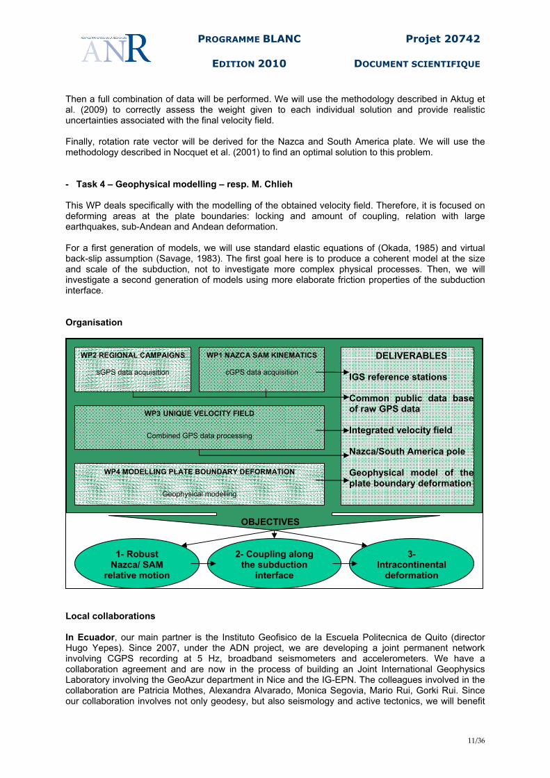
Then a full combination of data will be performed. We will use the methodology described in Aktug et al. (2009) to correctly assess the weight given to each individual solution and provide realistic uncertainties associated with the final velocity field. Finally, rotation rate vector will be derived for the Nazca and South America plate. We will use the methodology described in Nocquet et al. (2001) to find an optimal solution to this problem. - Task 4 – Geophysical modelling – resp. M. Chlieh This WP deals specifically with the modelling of the obtained velocity field. Therefore, it is focused on deforming areas at the plate boundaries: locking and amount of coupling, relation with large earthquakes, sub-Andean and Andean deformation. For a first generation of models, we will use standard elastic equations of (Okada, 1985) and virtual back-slip assumption (Savage, 1983). The first goal here is to produce a coherent model at the size and scale of the subduction, not to investigate more complex physical processes. Then, we will investigate a second generation of models using more elaborate friction properties of the subduction interface. Organisation
Local collaborations In Ecuador, our main partner is the Instituto Geofisico de la Escuela Politecnica de Quito (director Hugo Yepes). Since 2007, under the ADN project, we are developing a joint permanent network involving CGPS recording at 5 Hz, broadband seismometers and accelerometers. We have a collaboration agreement and are now in the process of building an Joint International Geophysics Laboratory involving the GeoAzur department in Nice and the IG-EPN. The colleagues involved in the collaboration are Patricia Mothes, Alexandra Alvarado, Monica Segovia, Mario Rui, Gorki Rui. Since our collaboration involves not only geodesy, but also seismology and active tectonics, we will benefit
WP3 UNIQUE VELOCITY FIELD
Combined GPS data processing
WP2 REGIONAL CAMPAIGNS
sGPS data acquisition
WP1 NAZCA SAM KINEMATICS
cGPS data acquisition
WP4 MODELLING PLATE BOUNDARY DEFORMATION
Geophysical modelling
1- Robust Nazca/ SAM
relative motion
2- Coupling along the subduction
interface
3- Intracontinental
deformation
OBJECTIVES
DELIVERABLES IGS reference stations Common public data base of raw GPS data Integrated velocity field Nazca/South America pole Geophysical model of the plate boundary deformation

PROGRAMME BLANC
EDITION 2010
Projet 20742
DOCUMENT SCIENTIFIQUE
12/36
from the results of side projects. First, arrival time catalogue of earthquakes are currently being re-analyzed to build a homogeneous earthquakes catalogue at the scale of Ecuador. Such hypocenter will be used to improve the geometry model of the subduction interface, a key element in modelling. When possible, focal mechanisms are determined. Finally, J.-M. Nocquet is a co-supervisor (supervisor is L. Audin, LGIT Grenoble, France) of a PhD recently started on the active tectonics in the central Ecuadorian Andes. Data collected under these projects will be available to the present work and will help to constrain the location of deformation in the Andean domain and could be used as a guide in kinematics modelling. Our collaboration with IG-EPN ensures the logistic support required for campaigns and CGPS installation and maintenance. In Peru, our collaborator is the Instituto Geofisico del Peru (IGP) – Lima, Departamento de Sismologia (resp. Hernando Tavera). A PhD (J.C. Villegas, IGP) on the analysis of the ADN campaign data is planned to start this year. We also cooperate with the French “Institut pour la Recherche et le Développement” (IRD), which has geodetic activities in the country (F. Bondoux, H. Perfettini). In Chile, we have a long history of active and productive collaboration with our partners in this project: Universidad de Chile. Since 2006 this collaboration has been formally recognized and structured with the Laboratoire International Associé (LIA) “Montessus de Ballore”, a formal collaborative structure between CNRS and Universidad de Chile. The colleagues mostly involved in this cooperation are Jaime Campos for seismology, Sergio Barrientos and Daniel Carrizo (PostDoc) for geodesy, Gabriel Vargas for geology and tectonics. We also work in close relation with the “servicio sismologico” who is in charge of operating and maintaining the acquisition of seismological data all over Chile. The GPS data acquired in the frameworks of our common projects (both continuous and campaign style) are archived at U-Chile, and available there. Through our colleagues in Chile, Ecuador and Peru, we also have connections to colleagues in Argentina (Patricia Alvarado, San Juan University), that will help concerning the installation of cGPS at the inland tips of the profiles. Logistics and funding distribution Obviously, the logistics will be more efficiently organized country per country and not simply per task. In particular, the success of our project also relies on the local collaboration that we have developed over the past years. Therefore, even though every task has specified budget and a designated coordinator, partner’s allocations don’t simply match task PI’s affiliations. Thus, funding will be dispatched to the partner’s institutions, in correspondence with their links to the different countries, regardless of their level of implication in each individual task.
3.2. COORDINATION DU PROJET / PROJECT MANAGEMENT
The specificity of this project is that it aims at organizing and coordinating similar activities (GPS surveys and cGPS) in neighbouring countries. The rationale for this is that common measurements and common processing provide much better geodetic accuracy than hypothetical combination of heterogeneous works. This does not apply to any scientific activity (i.e. seismology, where national networks devoted to micro seismicity don’t necessarily need to be operated jointly; or geology where distinct field works can be analyzed and combined through literature later on) and is very specific to GPS geodesy: baselines can be accurately computed across borders, provided that sites at both ends are measured simultaneously with similar hardware. The only difficulty, and this is where more people are involved, concerns the organization of field work (cGPS stations installation and GPS surveys). Therefore, and apart from field work, the project is quite simple and straightforward: we don’t need to coordinate different type of activities with very different rationales, ways and means. We simply need to coordinate one thematic activity in different countries. Additionally, the number of tasks is limited to 4 and all PIs participate to all tasks.
PROGRAMME BLANC
EDITION 2010
Projet 20742
DOCUMENT SCIENTIFIQUE
13/36
For all these reasons, we do not sense the necessity of having a specific task devoted to coordination. The coordination will be naturally achieved through regular and frequent work meetings, easy to organize, given the limited number of people involved.
3.3. DESCRIPTION DES TRAVAUX PAR TÂCHE / DETAILED DESCRIPTION OF THE WORK ORGANISED BY TASKS
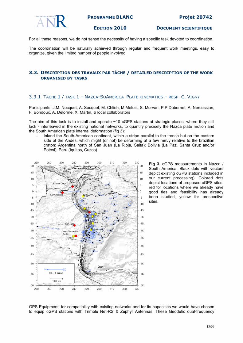
3.3.1 TÂCHE 1 / TASK 1 – NAZCA-SOAMERICA PLATE KINEMATICS – RESP. C. VIGNY Participants: J.M. Nocquet, A. Socquet, M. Chlieh, M.Métois, S. Morvan, P.P Dubernet, A. Nercessian, F. Bondoux, A. Delorme, X. Martin. & local collaborators The aim of this task is to install and operate ~10 cGPS stations at strategic places, where they still lack - interleaved in the existing national networks, to quantify precisely the Nazca plate motion and the South American plate internal deformation (fig 3):
- Inland the South-American continent, within a stripe parallel to the trench but on the eastern side of the Andes, which might (or not) be deforming at a few mm/y relative to the brazilian craton: Argentina north of San Juan (La Rioja, Salta); Bolivia (La Paz, Santa Cruz and/or Potosi); Peru (Iquitos, Cuzco)
Fig 3. cGPS measurements in Nazca / South America. Black dots with vectors depict existing cGPS stations included in our current processing). Colored dots depict locations of proposed cGPS sites: red for locations where we already have good ties and feasibility has already been studied, yellow for prospective sites.
GPS Equipment: for compatibility with existing networks and for its capacities we would have chosen to equip cGPS stations with Trimble Net-RS & Zephyr Antennas. These Geodetic dual-frequency

PROGRAMME BLANC
EDITION 2010
Projet 20742
DOCUMENT SCIENTIFIQUE
14/36
receivers allow to acquire data at high sampling rate (up to 10Hz - useful in case of earthquake) and geodetic sampling rate (30s) simultaneously. Their capacity to internally store data up to 1 Gb is precious in case of local computer failure or data transmission rupture. The Net-Rs has also been chosen by most of the scientific groups working in south America (Caltech, CNRS, etc…), and national geodetic agencies (RAMSAC in Argentina and RBMC in Brazil). We have accumulated a lot of experience with this equipment over the last 4-6 years. However, with the halt of Trimble NetRS production, in the absence of a clear alternative solution yet, we leave open the choice of the geodetic equipment. We will use high geodetic quality bi-frequency cGPS receiver, with build-in internet capacities and equipped with geodetic antenna benefiting from absolute calibration. For the sites that will be integrated within the IGS global tracking network, we will consider the possibility of buying receivers & antennas with Glonass and coming Galileo capacity. The first year will be devoted to hardware purchasing and station installation. We have accumulated a good experience of cGPS station installation over the last 4-5 years in Chile and Ecuador, by installing ~30 stations over this period. We will pay a special attention to data transmission: local internet if available, fast numerical telephone (Eon) otherwise. This type of transmission is efficient, fast and cheap, and becomes more and more easily available as local cellular telephone companies develop their networks. The following years will be devoted to maintenance of these stations, data streaming and data processing on a regular basis. This project data will be simply concatenated with existing data flows and archiving in all countries, and in France, using the DT-INSU and GPSCOPE organization. Once the stations are online and their quality has been carefully checked, we will offer IGS to integrate part or all of them in their permanent network. These stations, crucial for plate tectonics, should significantly improve reference systems over south America and Pacific areas.
3.3.2 TACHE 2 / TASK 2 - REGIONAL GPS SURVEYS – RESP. A. SOCQUET Participants: J.M. Nocquet, M. Chlieh, C. Vigny, M. Métois, S. Morvan, F. Bondoux, A. Delorme, X. Martin The goal of this task is to perform yearly GPS campaigns along a series of regularly-spaced, dense profiles, in actively deforming areas. These campaign data will be processed in an integrated manner (Task 3) and will constrain the coupling on the subduction interface as well as intracontinental deformation (Task4). We will proceed in two steps (1: installation; 2: repeated measurements) : Step 1: Installation of additional profiles perpendicular to the subduction We will first install 5 additional dense profiles of specially designed markers, perpendicular to the trench (fig 4). These profiles are aimed at filling the gaps of data, in areas where we miss constrains on both the coupling on the subduction and th intracontinental deformation. These profiles will be as long as possible (i.e. crossing the borders if and where possible) in order to reach the stable South American craton, and with a site spacing of the order of 20 km. The chosen marker design is a rod, sealed directly in the bedrock, on which the GPS antenna is directly screwed. This ensures precise measurements, both for the centering of the antenna and vertical measurements, guarantying quality results after a few years of repeated campaigns only. Step 2: Repeated GPS surveys

PROGRAMME BLANC
EDITION 2010
Projet 20742
DOCUMENT SCIENTIFIQUE
15/36
Together with the new profiles, we will resurvey existing networks every year (fig 4). The GPS surveys will be performed at the same period of the year, each year in order to reduce seasonal artifacts. Each point is measured at least during two 24-hour sessions, with a 30 seconds sampling, using dual-frequency receivers and geodetic antennas ensuring high quality measurements. The different surveys, in the three countries, will be performed simultaneously when possible, in order to directly measure a maximum of baselines between stations. This should guarantee a good consistency of the geodetic network and help for the data sets combination. In addition, the numerous permanent GPS stations in the area will ensure a stable reference frame and help tying sites that could not be measured in a common time window. The GPS receivers used to perform the measurement campaigns will be provided cost-free by the French INSU instrumental pool and by local GPS pools in Chile, Peru and Ecuador.
Fig. 4: Map of survey GPS points across the Andes. Blue dots and triangles depict existing benchmarks. Black lines show the profiles that we plan to create, densify or prolonge. We want to densify the existing networks and fill the gap between disconnected networks in the 3 countries: Ecuador:
- Esmeraldas- Lago Agrio (north) - Salinas – Macas + Iquitos (Peru)
We are currently discussing access to existing data with the Ecuadorian mapping agency (IGM). If data are available and of “geophysical” quality, the funding will be used to re-survey existing sites Peru:
- San Juan – Cuzco – Pueto Maldonado
- Ilo – Puno –La Paz (Bolivia) Part of the funding will be used for re-measuring profiles already installed in northern Peru Chile:
- Pisagua - Miñi-Miñi and extending to Bolivia, from Colchane to santa Cruz.
- Taltal – Azufrera - Chanaral/Caldera – Tinogasta and
farther east in Argentina. Part of the funding will be used for re-measuring networkss already installed in Chile
3.3.3 TÂCHE 3 / TASK 3 – TOWARDS A UNIQUE REGIONAL VELOCITY FIELD – RESP. J.-M. NOCQUET Participants: A. Socquet, M. Chlieh, C. Vigny, M. Métois, S. Morvan
PROGRAMME BLANC
EDITION 2010
Projet 20742
DOCUMENT SCIENTIFIQUE
16/36
The main objective of this task is to process or re-process all available data in western South America and the Nazca plate in order to produce a geodetic velocity field with its associated realistic uncertainty. The velocity field will then be used for the modelling described in Task 4. Task 3.1. Create a single extensive data archive We will first gather all available data for the Nazca and South America plate. This includes all data that we have individually collected so far; We will also make use of the UNAVCO data archive to reprocess publicly available data. Finally, we have several agreements with institutes which are developing CGPS network and have existing archive. In Ecuador, we will use data from about 50 campaign sites observed since 1994 by the Instituto Geografico Militar (IGM-Quito), which will be processed jointly by GeoAzur and IGM in 2010. We will include 5 CGPS stations operated by our collaborator of Instituto de Geofisica-Escuela Politecnica Navcional-Quito. In Peru, we are in the process of having an agreement of data exchange with the LISN project for adding about 10 CGPS sites in Peru. Task 3.2. Organization of an international workshop In order to foster collaboration, we are planning to organize an international workshop of the geodesy. This workshop will offer a unique opportunity to gather all international groups working on geodetic measurements in the Andean country. Details are provided in section 3.1. Task 3.3. Distributed Analysis We will analyze the GPS data available using a homogeneous up-to-date processing strategy, using the GAMIT software to get the highest accuracy possible. We will take the advantage of the global reprocessing of orbits recently led by the IGS to get the highest accurate orbits that might help to resolve ambiguities on long baseline, therefore improving reference frame definition especially for old data. Our processing will include as many IGS sites as possible to improve the reference frame definition. Our processing will include all state-of-art correction and modelling like Ocean and Atmospheric loading, absolute phase centers correction, tropospheric correction using the Vienna Mapping function. The processing load will be divided among the ENS, IPGP and GeoAzur, but will use common IGS sites , identical strategy and processing tables. Task 3.4. Time series analysis & Combination At this step, we will produce the time series for campaign and CGPS sites first using a simple 7-parameters transformation onto the current ITRF. We will probably take benefit of the availability of the new release of the ITRF (ITRF2008). At this step, we will check for outliers, and assess the quality of each campaign and make test for an optimal definition of the reference frame. For cGPS data, we will form the time series from daily solutions. We will investigate the benefit of correcting the result from the hydrological loading, which is known to be larger than 1 cm in the Amazonian basin and may impact our results. We will use the approach described in Williams (2003) to evaluate the time correlated noise in GPS time series and derived realistic uncertainties on velocities. This result will then be used to rescale the weight attributed to individual solution when doing the final combination. Similarly, we will investigate the best methodology to provide the proper uncertainty to campaign data using either empirically derived noise properties, or rescaling scheme based on the agreement to nearby CGPS data. We have all the software tools to do the methodological investigation, including a good experience on the Globk and CatRef software, and a software dedicated to this methods currently in development at GeoAzur. While the work will start at the beginning of the project, it will be regularly updated as more data will become available in the time of the project. The result of this task will be a single, homogeneous velocity field expressed in the current release of the global reference frame (ITRF), with its associated full variance-covariance matrix. Task 3.5. Defining stable plates interior We will use the approach described in Nocquet et al. (2001) to find the optimal definition of the stable part of the Nazca and South America plate. The method uses Student, F-ratio and chi-square test to
PROGRAMME BLANC
EDITION 2010
Projet 20742
DOCUMENT SCIENTIFIQUE
17/36
decide whether a subset of sites behaves rigidly or not, taking into account the full information of its precision. As a result, an optimum subset of site is proposed for each plate, with statistical information on the possible internal deformation and uncertainty of the relative motion between two plate at a given location. This will be particularly useful to discriminate whether the Easter Island belongs to a micro-plate independent from the Nazca plate. Similarly, it will provide information on the possible deformation induced by volcanic activity in the Galapagos. Finally, it will be particularly useful to determine how deeply the deformation east of the Andes penetrates the South American continent. The result of this task will be a velocity field expressed with respect to Stable South America, and the kinematics of the Nazca wrt South America with its uncertainty.
3.3.4 TÂCHE 4 / TASK 4 – GEOPHYSICAL MODELLING – RESP. M. CHLIEH Participants: J.M. Nocquet, A. Socquet, C. Vigny, M. Métois The main objective of this work package is to identify the seismic asperities likely to generate great earthquakes (Mw>8.5) in a near future along the South America subduction zone. With better constraints on the kinematic of the Nazca plate, the Andean sliver and the south America craton, we will be able to discriminate between the 2-plate and the 3-plate model and dissociate the pattern of deformation at the plate boundaries. This will allow us to isolate the interseismic deformation field issue from the coupling between the Nazca plate and the Andean Sliver on one hand; and the sub-andean shortening field between the Andean sliver and the South America craton on the other hand. Then, we will model the interseismic accumulation on the subduction using the classical back-slip approach (Savage, 1983). We will start our exploration with homogeneous coupling models using various inversion schemes including the complexity of the slab geometry. We will first map in detail the trench and try to constrain the slab geometry, that varies along strike, using seismic profiles and relocated seismicity. Concerning this last point, thanks to our collaboration with the different countries, we will benefit from the seismologic data base of the Nacional Servicios Sismologicos that systematically relocate seismicity using local networks. In parallel, we will explore the slab geometry using our GPS data only (a direct inversion of the geometry being highly non linear, a parameter’s exploration will give better insights on trade-off between parameters). In a second time, we will allow for lateral variations of the amount and depth of coupling. We will refine these models allowing heterogeneous coupling complexities as proposed for other subduction zones (Bürgmann et al. 2005, Chlieh et al. 2008) resulting to detailed asperities map. Figure 5 shows two heterogeneous coupling models for a 2-plates approach where all the convergence of 63 mm/yr is accommodated on the subduction megathrust and a 3-plates approach where 10 mm/yr of shortening is accommodated on the sub-andean regions. The moment deficit that is accumulating on the subduction megathrust is reduced by 40% in the presence of an Andean sliver moving independently with respect to South America (3-plate model). These preliminary models indicate that small variations in the determination of the convergence and of the shortening (that could cumulate up to 10 mm/yr) affect significantly the determination of the coupling.

PROGRAMME BLANC
EDITION 2010
Projet 20742
DOCUMENT SCIENTIFIQUE
18/36
Fig. 5: Preliminary model of the observed velocity field in the Central Andes. Top: 2-plates model. Bottom: 3-plates models, including an Andean block. The 3-plates model involves 10mm/yr of shortening between the Andean block and Stable America. As a consequence, the subduction rate decreases from 63 mm/yr (2-plates model) to 53 mm/yr). It leads to a reduction of 40% of the coupling along the subduction interface in southern Peru. The black contour lines correspond to the 1-m coseismic slip contours of the 2007 Mw8.0 Pisco, 1996 Mw7.7 Nazca, 2001 Mw8.4 Arequipa and 2007 Mw7.9 Tocopilla earthquakes deduced from geodetic inversions.
Those precise coupling maps will be compared to the source of recent and historical large earthquakes in order to identify along the subduction zone: (1) highly coupled zones that could act as asperities where future large earthquakes would nucleate, and (2) permanent creeping segments that could stop earthquake propagation. Rupture scenarios involving the individual or cooperative breakage of those asperities will be identified using numerical modelling. Satellite imagery and/or paleo-geodetic observations could also provide some constraints on the vertical motion. In particular, InSAR data has been revealed to provide good constraints on that component of deformation in South America (Chlieh et al. 2004, Pritchard et al. 2007, Bejar et al., submitted to GJI). Some of us are involved in other projects funded by the European Space Agency (ESA) aiming at mapping with INSAR the deformation over some areas covered in this proposal. When these data are available, we will integrate them with our GPS measurements and perform joint geodetic inversions.
PROGRAMME BLANC
EDITION 2010
Projet 20742
DOCUMENT SCIENTIFIQUE
19/36
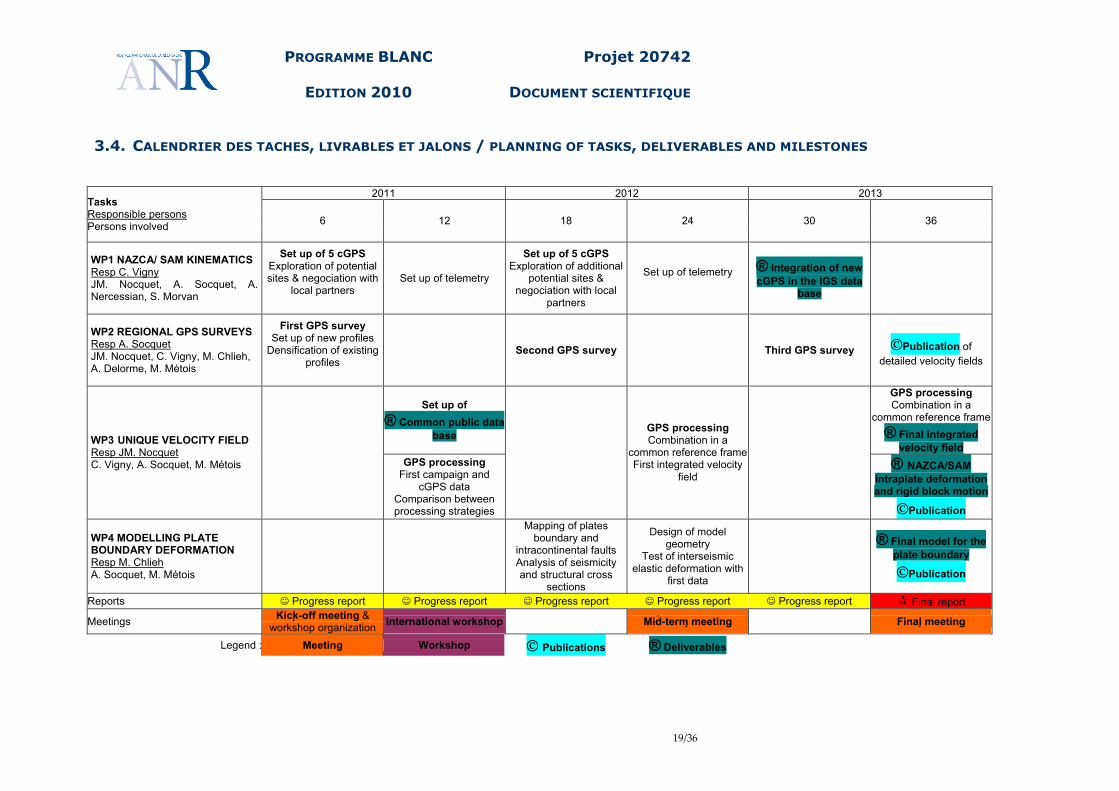
3.4. CALENDRIER DES TACHES, LIVRABLES ET JALONS / PLANNING OF TASKS, DELIVERABLES AND MILESTONES
2011 2012 2013 Tasks Responsible persons Persons involved 6 12 18 24 30 36
WP1 NAZCA/ SAM KINEMATICS Resp C. Vigny JM. Nocquet, A. Socquet, A. Nercessian, S. Morvan
Set up of 5 cGPS Exploration of potential sites & negociation with
local partners
Set up of telemetry
Set up of 5 cGPS Exploration of additional
potential sites & negociation with local
partners
Set up of telemetry
® Integration of new cGPS in the IGS data
base
WP2 REGIONAL GPS SURVEYS Resp A. Socquet JM. Nocquet, C. Vigny, M. Chlieh, A. Delorme, M. Métois
First GPS survey Set up of new profiles
Densification of existing profiles
Second GPS survey Third GPS survey ©Publication of detailed velocity fields
Set up of ® Common public data
base
GPS processing Combination in a
common reference frame ® Final integrated
velocity field WP3 UNIQUE VELOCITY FIELD Resp JM. Nocquet C. Vigny, A. Socquet, M. Métois
GPS processing
First campaign and cGPS data
Comparison between processing strategies
GPS processing Combination in a
common reference frameFirst integrated velocity
field
® NAZCA/SAM
intraplate deformation and rigid block motion
©Publication
WP4 MODELLING PLATE BOUNDARY DEFORMATION Resp M. Chlieh A. Socquet, M. Métois
Mapping of plates boundary and
intracontinental faults Analysis of seismicity and structural cross
sections
Design of model geometry
Test of interseismic elastic deformation with
first data
® Final model for the
plate boundary
©Publication
Reports ☺ Progress report ☺ Progress report ☺ Progress report ☺ Progress report ☺ Progress report Final report Meetings Kick -off meeting &
workshop organization International workshop Mid-term meeting Final meeting
Legend : Meeting Workshop © Publications ® Deliverables
PROGRAMME BLANC
EDITION 2010
Projet 20742
DOCUMENT SCIENTIFIQUE
20/36
Deliverables
1. Data base of geodetic measurements in South America. All acquired measurements will be archived and distributed by a centralized system at INSU/CNRS (GPSCOPE). Data will be freely and immediately available.
2. Combined solution (coordinates and velocity field over hundreds of points) in a common
reference frame at the scale of the continent.
3. Precise quantification of the Nazca-South America convergence rate
4. Precise quantify of the internal deformation of the South-American craton
5. Quantification of the amount of shortening available for the orogene of the Andes and current intra-plate fault motion.
6. Assessment of seismic hazard on distinct segments of the subduction and intra-plate
faults
7. Publications in international research journals
PROGRAMME BLANC
EDITION 2010
Projet 20742
DOCUMENT SCIENTIFIQUE
21/36
4. STRATEGIE DE VALORISATION DES RESULTATS ET MODE DE
PROTECTION ET D’EXPLOITATION DES RESULTATS / DATA
MANAGEMENT, DATA SHARING, INTELLECTUAL PROPERTY AND
RESULTS EXPLOITATION Science and Research
• Scientific papers and international conferences • PhD thesis: the project developments and deliverables will lead to new PhD projects, during
and after the projects especially in the domain of GPS data processing, plate kinematics, monitoring and modelling of transient slip events, and segmentation along subduction zones.
• The operation of the international observational facilities in Chile, Ecuador and Peru will continue after the end of the project and contribute to national and international data bases open to the scientific community.
• The GPS networks and the results of this project will guide the selection of future sites of the Chilean “RED Nacional” project.
• Dissemination of GPS products (Atmospheric delays, Ionospheric scintillation, real time high rate data for surveyors) to external communities.
• Submission of some of our cGPS stations data to IGS, for automatic inclusion in the IGS network, data processing and ITRF realization.
Hazard and Risk
• end-users: contact will be maintained with local public authorities to improve communications between scientists, engineers, public and authorities
• end-users: if relevant continuous and almost real time monitoring of tremors through high rate real time cGPS
International Collaborations
• coordination with other international projects on active margins in Chile, Peru and Ecuador and on the stable interior of the continental plate in Bolivia, Argentina and Brazil.
• Initiation of a French – South American federation or confederation, on the model of the French-chilean LIA “Montessus de Ballore”. Clearly, this “GPS geodesy only project” as the potential of being a first step towards a broader cooperation in the seismo-tectonic area of science between France on one side, and South American countries on the other side. This initiative is supported by the existence of a “Latin American Bureau” maintained by CNRS.
Communication to various public
• project web sites pages for general publication

PROGRAMME BLANC
EDITION 2010
Projet 20742
DOCUMENT SCIENTIFIQUE
22/36
5. ORGANISATION DU PARTENARIAT / CONSORTIUM ORGANISATION
AND DESCRIPTION
5.1. DESCRIPTION, ADÉQUATION ET COMPLÉMENTARITÉ DES PARTENAIRES / RELEVANCE AND COMPLEMENTARITY OF THE PARTNERS WITHIN THE CONSORTIUM
As stated previously, all participants to this proposal share capacities in GPS data acquisition, processing and modelling. The main complementarity comes from the fact that over the past years, each of us has developed new GPS measurements in Ecuador, Peru and Chile and can share the load of a complete reprocessing of data. ENS Over the last 6 years, C. Vigny, with collaborations with DGF at U-Chile, Santiago have been developing a cGPS network in central Chile. While a couple of pre-existing stations had been installed in the mid 1990’s by IPGP teams (J.C. Ruegg), our network includes now 24 cGPS stations. These networks cover 3 segments of the subduction: 1) from Concepcion to Constitucion, 2) Valparaiso, 3) Los Vilos – Vallenar. We also continuously install and survey geodetic benchmarks in campaign modes. Our data base includes over 100 points in central Chile (between Concepcion and Vallenar), a significant portion of which we survey regularly every year. We implemented automatic processing of the cGPS stations data and we regularly process ourselves our campaign data using the GAMIT/GLOBK package from MIT. We are currently working on modelling the accumulation of deformation in this area of Chile, taking into account the slab geometry, the segmentation of the subduction and the amount of coupling on the interface. Monitoring crustal deformation along subductions (using GPS and seismology) is an identified project of the “laboratoire de Géologie de l’ENS” research plan. IPGP A. Socquet took the responsibility of a cGPS network within the North Chile seismic gap in collaboration with Chilean colleagues from the University of Chile (Departamento de Geofisica) in Santiago and the Universidad Arturo Pratt in Iquique. This cGPS network is now made of 16 operating stations. The first IPGP/DGF sites were installed in 2000 (by JB de Chabalier and JC Ruegg), although ~half of the sites were installed since 2007. In addition, a series of campaign points along 4 profiles perpendicular to the subduction were first installed by Jean Claude Ruegg (IPGP) in 1992. The cGPS network has been developed in a complementary manner with other cGPS networks in the same area:
- 3 additional French sites maintained by IRD (S. Bonvalot, F. Bondoux) running since 2004 - a cGPS network of 16 sites developed by Caltech (M. Simons, G. Genrich) since 2006 - a cGPS network developed by German colleagues (J. Klotz, GFZ) since 2008
A data exchange protocol between the different parts ensures a smooth collaboration between partners. In terms of GPS data analysis, Anne Socquet has been mainly work on plate motion issues and deformation at the plate boundary in South East Asia. In addition she is involved in plate tectonics modelling, as well as elastic modelling of earthquake signals and interseismic loading, using geodetic
PROGRAMME BLANC
EDITION 2010
Projet 20742
DOCUMENT SCIENTIFIQUE
23/36
data (GPS + InSAR), in various tectonic contexts. She is author or co-author of eleven papers dealing with these problematics. GeoAzur J.-M. Nocquet, together with collaborators from the IG-EPN in Quito is developing a cGPS network in Ecuador. Currently, about 15 CGPS sites are operating, with a higher density along the northern central Ecuadorian coast. Most of the network is operating since December 2008. This network in augmented by ~40 campaign sites covering the whole country from the Amazonian basin to the coast. This network has been observed in 1994, then partially in 1996 and 1999, and fully observed in 2009. M. Chlieh and J.-M. Nocquet at GeoAzur, together with collaborators from the IGP-Lima have developed a campaign network of 50 sites from Lima to the Ecuadorian border, with 4 profiles crossing the Andes. The network is complemented by 5 sites installed along the coast every 200 km. In terms of GPS data analysis, J.-M. Nocquet has worked mainly in the Mediterranean, and has developed methodology to detect slow strain rate, as well as combining heterogeneous geodetic data set. J.-M. Nocquet is currently in charge of the French national CGPS network data base RENAG and its routine processing (http://webrenag.unice.fr). In terms of modelling, M. Chlieh has published several papers on modelling inter-, co- and post- seismic deformation along major subduction zones.
5.2. QUALIFICATION DU COORDINATEUR DU PROJET / QUALIFICATION OF THE PROJECT COORDINATOR
Christophe Vigny at ENS has a long experience of GPS data acquisition (both survey and cGPS) in many areas of the world. Over the last 20 years he designed, installed and measured networks in Indonesia, Thailand, Myanmar, Nepal, Iran, Afar, Antarctica, the Alps, Greece and Chile. His work has been subject to ~30 publications in peer reviewed international newspaper, and high visibility journals like Nature for the case of Sumatra since the Earthquake and Tsunami of 2004. C. Vigny is one of the key actor in the “GPS applied to geodynamics” French community, having signed or co-signed a very significant part of the publications of this group. C. Vigny also as had some experience in managing projects or subprojects aimed at acquiring, processing and modelling GPS data (both survey and cGPS) funded by EC and ANR.
- GEODYSSEA (EC) 1994-1997: GPS measurements all over SE-Asia (Indonesia, Malaysia, Thailand, Vietnam, Philippines, Singapore, Brunei)
- SUB-CHILI (ANR) 2005-2008: GPS measurements in Chile - OPOSSUM (ANR) 2006-2009: deformation in Sumatra
Those projects included all aspects of this current proposal, including 3D-finate element modelling.
5.3. QUALIFICATION, ROLE ET IMPLICATION DES PARTICIPANTS / CONTRIBUTION AND QUALIFICATION OD EACH PROJECT PARTICPANT
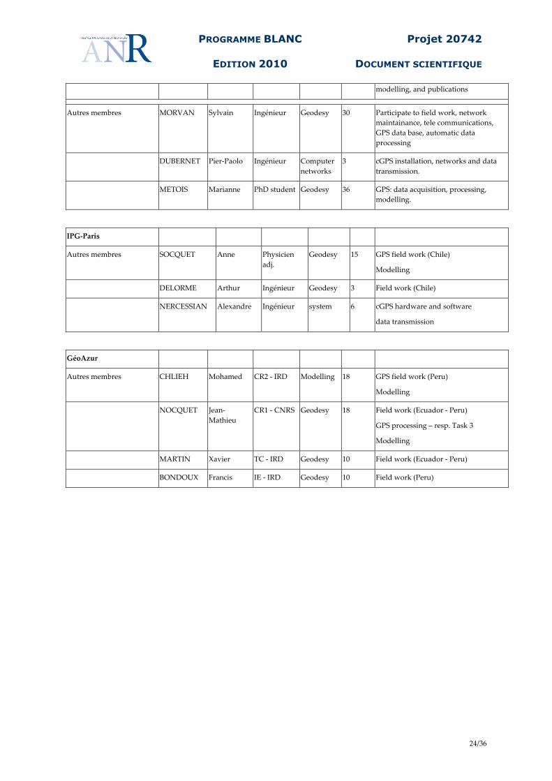
ENS Nom Prénom Emploi
actuel Discipline Personne
.mois Rôle/Responsabilité dans le projet
4 lignes max
Coordinateur/responsable VIGNY Christophe DR2 Geodesy 24 Direction & coordination
Responsible for cGPS task
network design, cGPS maintainance, GPS data acquisition, processing,
PROGRAMME BLANC
EDITION 2010
Projet 20742
DOCUMENT SCIENTIFIQUE
24/36
modelling, and publications
Autres membres MORVAN Sylvain Ingénieur Geodesy 30 Participate to field work, network maintainance, tele communications, GPS data base, automatic data processing
DUBERNET Pier-Paolo Ingénieur Computer networks
3 cGPS installation, networks and data transmission.
METOIS Marianne PhD student Geodesy 36 GPS: data acquisition, processing, modelling.
IPG-Paris
Autres membres SOCQUET Anne Physicien adj.
Geodesy 15 GPS field work (Chile)
Modelling
DELORME Arthur Ingénieur Geodesy 3 Field work (Chile)
NERCESSIAN Alexandre Ingénieur system 6 cGPS hardware and software
data transmission
GéoAzur
Autres membres CHLIEH Mohamed CR2 - IRD Modelling 18 GPS field work (Peru)
Modelling
NOCQUET Jean-Mathieu
CR1 - CNRS Geodesy 18 Field work (Ecuador - Peru)
GPS processing – resp. Task 3
Modelling
MARTIN Xavier TC - IRD Geodesy 10 Field work (Ecuador - Peru)
BONDOUX Francis IE - IRD Geodesy 10 Field work (Peru)

PROGRAMME BLANC
EDITION 2010
Projet 20742
DOCUMENT SCIENTIFIQUE
25/36
6. JUSTIFICATION SCIENTIFIQUE DES MOYENS DEMANDES /
SCIENTIFIC JUSTIFICATION OF REQUESTED BUDGET Obviously, the logistics will be more efficiently organized country per country and not simply per task. In particular, the success of our project also relies on the local collaboration that we have developed over the past years. Therefore, even though every task has specified budget and a designated coordinator, partner’s allocations don’t simply match task PI’s affiliations. Thus, funding will be dispatched to the partner’s institutions, in correspondence with their links to the different countries, regardless of their level of implication in each individual task. General lines of the total budget required: 1. GPS work 1.1. Equipment - Net-RS, UNAVCO price list (6,000 E), or equivalent x10 => 60 000 €- Specially designed marker (50 E) x100 => 5 000 €- Batteries 70 Ah (100 E) x20 => 2 000 €- Solar pannels (700 E) x10 => 7 000 €- Telecommunication (Eon, G3)(1000 E) x10 => 10 000 €- Field work (pillars, mast, drilling, etc..) x10 => 10 000 €- Small hardware tools (drill bit, glue, …) => 1 500 €1.2. Logistics 1.2.1 cGPS operations - cGPS international flights (2 personns, 1/year, 3 dest.) => 18 000 €- cGPS domestic flights (2personns, 1/year, 10 dest.) => 12 000 €- 4x4 car rental (100 E /day) x3x10daysx3years => 9 000 €- Food/lodging during visits (50 E/day/pers) x3x10daysx3years => 4 500 €- Combustible (1 E/liter) 250lx3x3years => 2 500 €1.2.2 GPS campaigns - GPS campaigns international flights (4personns, 1/year, 3 dest.) => 36 000 €- GPS campaigns domestic flights (4personns, 1/year, 10 dest.) => 24 000 €- 4x4 car rental (100 E /day) x3x15daysx9camp => 40 500 €- Food/lodging during camps. (50 E/day/pers) x3x15daysx9camp => 20 250 €- Combustible (1 E/liter) x1000x9camp => 9 000 € 2. Meetings and workshops - Organisation of 1 workshop, 10 invited persons from Eur and SAm => 15 000 €- Participation to AGU (air+reg+stay: 2,000 E) x1persx3times => 6 000 €
3. Publications - Publication in AGU journal (1,000E) x3pubs => 3 000 € 4. Contributions fonctionnement - ENS 4% of partner alloc. => 4 000 €- IPGP 4% of partner alloc => 4 000 €- Nice 4% of partner alloc. => 4 000 € TOTAL 306 900 €TOTAL (y compris frais prélevés par organismes gestionnaires 4092€ par part.) 319 176 €
PROGRAMME BLANC
EDITION 2010
Projet 20742
DOCUMENT SCIENTIFIQUE
26/36
6.1. PARTENAIRE 1 / PARTNER 1 : ENS 102,3 KE
• Équipement / Equipment GPS hardware (receivers&antennas) :
- 1/3rd of 10 receivers (Trimble Net-RS or equivalent) 20,0 kE
• Personnel / Staff No funding is requested here for this proposal
• Prestation de service externe / Subcontracting No funding is requested here for this proposal
• Missions / Missions Field work :
- cGPS: 1/3rd of operations 15,3 kE - surveys: 1/3rd of operations 43,2 kE
Congress/meetings/workshops :
- 1 AGU 2,0 kE - 1/3rd of this proposal South American workshop 5,0 kE
• Dépenses justifiées sur une procédure de facturation interne / Internal expenses - Lab contribution 4,0 kE
• Autres dépenses de fonctionnement / Other expenses - Small GPS hardware (markers, batteries, solar panels, drill bits, glue, pillars, etc….) 11,8 kE - Publications 1,0 kE
NB. + Frais de gestions prélevés par l’établissement gestionnaire des crédits (CNRS) 4,1 kE

PROGRAMME BLANC
EDITION 2010
Projet 20742
DOCUMENT SCIENTIFIQUE
27/36
6.2. PARTENAIRE 2 / PARTNER 2 : IPG-P 102,3 KE
• Équipement / Equipment GPS hardware (receivers&antennas) :
- 1/3rd of 10 receivers (Trimble Net-RS or equivalent) 20,0 kE
• Personnel / Staff No funding is requested here for this proposal
• Prestation de service externe / Subcontracting No funding is requested here for this proposal
• Missions / Missions Field work :
- cGPS: 1/3rd of operations 15,3 kE - surveys: 1/3rd of operations 43,2 kE
Congress/meetings/workshops :
- 1 AGU 2,0 kE - 1/3rd of this proposal South American workshop 5,0 kE
• Dépenses justifiées sur une procédure de facturation interne / Internal expenses - Lab contribution 4,0 kE
• Autres dépenses de fonctionnement / Other expenses - Small GPS hardware (markers, batteries, solar panels, drill bits, glue, pillars, etc….) 11,8 kE - Publications 1,0 kE
NB. + Frais de gestions prélevés par l’établissement gestionnaire des crédits (IPGP) 4,1 kE
PROGRAMME BLANC
EDITION 2010
Projet 20742
DOCUMENT SCIENTIFIQUE
28/36
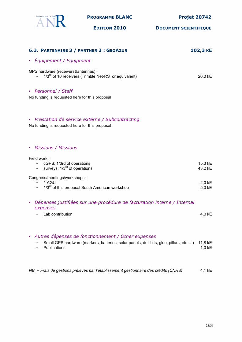
6.3. PARTENAIRE 3 / PARTNER 3 : GEOAZUR 102,3 KE
• Équipement / Equipment GPS hardware (receivers&antennas) :
- 1/3rd of 10 receivers (Trimble Net-RS or equivalent) 20,0 kE
• Personnel / Staff No funding is requested here for this proposal
• Prestation de service externe / Subcontracting No funding is requested here for this proposal
• Missions / Missions Field work :
- cGPS: 1/3rd of operations 15,3 kE - surveys: 1/3rd of operations 43,2 kE
Congress/meetings/workshops :
- 1 AGU 2,0 kE - 1/3rd of this proposal South American workshop 5,0 kE
• Dépenses justifiées sur une procédure de facturation interne / Internal expenses - Lab contribution 4,0 kE
• Autres dépenses de fonctionnement / Other expenses - Small GPS hardware (markers, batteries, solar panels, drill bits, glue, pillars, etc….) 11,8 kE - Publications 1,0 kE
NB. + Frais de gestions prélevés par l’établissement gestionnaire des crédits (CNRS) 4,1 kE
PROGRAMME BLANC
EDITION 2010
Projet 20742
DOCUMENT SCIENTIFIQUE
29/36
7. ANNEXES
7.1. RÉFÉRENCES BIBLIOGRAPHIQUES / REFERENCES
Inclure la liste des références bibliographiques utilisées dans ce document et les références bibliographiques des partenaires ayant trait au projet. B. Aktug, J.-M. Nocquet, et al., Deformation of western Turkey from a combination of permanent and
campaign GPS data: Limits to block•like behavior, (2009), J. Geophys. Res., 114, B10404,
2009, doi:10.1029/2008JB006000.
Altamimi, Z., X. Collilieux, J. Legrand, B. Garayt, and C. Boucher , ITRF2005: A new release of the
International Terrestrial Reference Frame based on time series of station positions and Earth
Orientation Parameters , J. Geophys. Res., 112, B9, doi:10.1029/2007JB004949, 2007
Angermann D., J. Klotz and C. Reigber, (1999), Space-geodetic estimation of the Nazca–South
America Euler vector, Earth and Planetary Science Letters, Volume 171, Issue 3, pages 329-
334
Brooks, B. A., M. Bevis, R. Smalley Jr., E. Kendrick, R. Manceda, E. Lauría, R. Maturana, and M.
Araujo, (2003), Crustal motion in the Southern Andes (26°36°S): Do the Andes behave like a
microplate?: Geochem. Geophys. Geosyst., v. 4, no.10, p. 1085, doi: 10.1029/2003GC000505
Bürgmann, R., M. G. Kogan, G. M. Steblov, G. Hilley, V. E. Levin, and E. Apel (2005), Interseismic
coupling and asperity distribution along the Kamchatka subduction zone, J. Geophys. Res., 110,
B07405, doi:10.1029/2005JB003648.
Chlieh, M., J. P. Avouac, K. Sieh, D. H. Natawidjaja, and J. Galetzka, Heterogeneous coupling of
the Sumatran megathrust constrained by geodetic, and paleogeodetic measurements, J.
Geophys. Res., 113, B05305, 2008,doi:10.1029/2007JB004981.
DeMets C, Gordon RG, Argus DF, Stein S (1990) Current plate motions. Geophys J Int 101(2):425-
478.
DeMets C, Gordon RG, Argus DF, Stein S (1994) Effect of recent revisions to the geomagnetic
reversal time-scale on estimates of current plate motions. Geophys Res Lett 21(20):2191-2194,
DOI: 10.1029/94GL02118.
Herring T. A., R. W. King and S. C. McClusky, (2008), GAMIT/GLOBK Reference Manual, Release
10.33, Department of Earth, Atmospheric, and Planetary Sciences, Massachussetts Institute of
Technology.
Iaffaldano G., Bunge H. P., et T. H. Dixon, (2006), Feedback between mountain belt growth and plate
convergence, Geology, Volume 34, Issue 10 (October 2006) pp. 893–896, DOI:
10.1130/G22661.1
Kanamori, H., and K. C. McNally, (1982.) Variable rupture mode of the subduction zone along the
Ecuador-Colombia coast, Bull. Seismol. Soc. Am., 72(4), 1241– 1253.
Khazaradze, G., and J. Klotz (2003), Short and long-term effects of GPS measured crustal
deformation rates along the South-Central Andes. J. of Geophys. Res., 108, n°B4, 1-13
PROGRAMME BLANC
EDITION 2010
Projet 20742
DOCUMENT SCIENTIFIQUE
30/36
Kellogg J. N. et W. E. Bonini (1985), Subduction of the Caribbean Plate and Basement, Uplifts in the
overiding South American Plate. Tectonics, 1, 3, 251-276.
Kendrick, E., M. Bevis, R. Smalley, and B. Brooks (2001), An integrated crustal velocity field for the
central Andes. Geochemistry, Geophysics, Geosystems, Vol.2
Kendrick E., M. Bevis, R. Smalley Jr., B. Brooks, R. B. Vargas, E. Lauria, L. P. Souto Fortes, (2003),
The Nazca-South America Euler vector and its rate of change, Journal of South American Earth
SciencesVolume 16, Issue 2, Pages 125-131. doi:10.1016/S0895-9811(03)00028-2
Klotz, J., G. Khazaradze, D. Angermann, C. Reigber, R. Perdomo, and O. Cifuentes (2001),
Earthquake cycle dominates contemporary crustal deformation in Central and Southern Andes,
Earth and Planetary Sciences Letters, 193, 437-446
Larson, K., J. Freymueller, and S. Philipsen, Global plate velocities from the Global Positioning
System, J. Geophys. Res., 102, B5, doi:10.1029/97JB00514, 1997
Nocquet, J.-M. , E. Calais, Z. Altamimi, P. Sillard, C. Boucher, Intraplate deformation in western
Europe deduced from an analysis of the ITRF97 velocity field , (2001), Journal of Geophysical
Research, Vol. 106 , No. B6 , p. 11,239.
Norabuena, E., L. Leffler-Griffin, A. Mao, T. Dixon, S. Stein, I. Sacks, L. Ocala & M. Ellis, (1998),Space
geodetic observation of Nazca–South America convergence across the Central Andes. Science
279 (1998), pp. 358–362.
Norabuena, E., T. Dixon, S. Stein, and C. Harrison (1999), Decelerating Nazca-South America and
Nazca-Pacific Plate Motions, Geophys. Res. Lett., 26(22), 3405-3408.
Pennington, W.D., (1981), Subduction of the Eastern Panama Basin and seismotectonics of North
Western South America. J. Geophys. Res. 86, 10753-10770.
Ruegg, J.C., A. Rudloff, C. Vigny, R. Madariaga, J.B. DeChabalier, J. Campos, E. Kausel, S.
Barrientos, D. Dimitrov, Interseismic strain accumulation measured by GPS in the seismic gap
between Constitucion and Concepcion in Chile, PEPI, Vol 175, issue 1-2, June,
10.1016/j.pepi.2008.02.015, 2009.
Savage, J.C., (1983). A dislocation model of strain accumulation and release at a subduction zone, J.
geophys. Res., 88, 4984–4996.
Trenkamp R., J.N. Kellogg, J. Freymueller and H. Mora, (2002), Wide plate margin deformation,
southern Central America and northwestern South America, CASA GPS observations. J. S AM.
Earth Sci. 15, pp. 157–171.
Vigny, C., A. Rudloff, J.C. Ruegg, R. Madariaga, J. Campos, M. Alvarez , Upper plate deformation
measured by GPS in the Coquimbo gap, Chile, PEPI, Vol 175, issue 1-2, June,
10.1016/j.pepi.2008.02.013, 2009.
White S.M., Trenkamp R., Kellogg J, (2003), Recent crustal deformation and the earthquake cycle
along the Ecuador-Colombia subduction zone, Earth and Planetary Science Letters, Volume
216, Number 3, pp. 231-242(12), DOI: 10.1016/S0012-821X(03)00535-1

PROGRAMME BLANC
EDITION 2010
Projet 20742
DOCUMENT SCIENTIFIQUE
31/36
7.2. BIOGRAPHIES / CV, RESUME
PROGRAMME BLANC
EDITION 2010
Projet 20742
DOCUMENT SCIENTIFIQUE
32/36
Mohamed Chlieh [email protected] CR2 IRD Born 22/04/1973 French, Married. Education 2007- : « Chargé de recherche 2eme classe » at « IRD », now at GeoAzur, Nice 2003-2007 : Post-doc at California Institute of Technology 2003 PhD Géophysique Interne de l'Institut de Physique du Globe de Paris. Advisor : R. Armijo. Title: « Le Cycle sismique décrit avec les données de la Géodésie Spatiale (InSAR et
GPS différentiel) : Variations Spatio-temporelles des glissements stables et instables sur l’interface de subduction du Nord Chili. ».
Publications - 11 in peer-reviewed international journals Ioualalen, M, Arreaga-Vargas, P., N. Pophet, M. Chlieh, J. Asavanant, K. Ilayaraja, J.
Ordonez and N. Pazmino, (2009). Numerical modelling of the 26th December 2004 Indian Ocean tsunami for the South-Eastern coast of India, Pure and Applied Geophys. – in press.
Chlieh, M., J. P. Avouac, K. Sieh, D. H. Natawidjaja, and J. Galetzka 2008, Heterogeneous coupling of the Sumatran megathrust constrained by geodetic and paleogeodetic measurements, J. Geophys. Res., 113, B05305, doi:10.1029/2007JB004981. Konca, O., et al. (2008). Partial rupture of a locked patch of the Sumatra megathrust
during the 2007 earthquake sequence. Nature 456, 631-635. doi:10.1038/nature07572
Ilayaraja, K., M. Ioualalen, M. Chlieh, R. R. Krishnamurthy and M. V. Ramana Murthy. Numerical modeling of the 26th December 2004 India Ocean tsunami at Andaman and Nicobar Islands, doi:10.1007/s11852-008-0033-8
Chlieh, M., Avouac, J.-P., Hjorleifsdottir, V., Song, T.-R. A., Ji, C., Sieh, K., Sladen, A., Hebert, H., Prawirodirdjo, L., Bock, Y., and Galetzka, J., 2007, Coseismic Slip and Afterslip of the Great (Mw9.15) Sumatra-Andaman Earthquake of 2004: Bull. Seism. Soc. Am., Vol. 97, 1A, pp. S157-S173, doi: 10.1785/0120050631.
Chlieh, M., de Chabalier, J. B., Ruegg, J. C., Armijo, R., Dmowska, R., Campos, J., and Feigl, K. L., 2004, Crustal deformation and fault slip during the seismic cycle in the North Chile subduction zone, from GPS and InSAR observations: Geophys J Int., v.158, p. 695-711.
Subarya, C., Chlieh, M., Prawirodirdjo, L., Avouac, J. P., Bock, Y., Sieh, K., Meltzner, A., Natawidjaja, D., and McCaffrey, R., 2006, Plate-boundary deformation associated with the great Sumatra–Andaman earthquake: Nature, v. 440, p. 46-51.
Hsu, Y.et al., 2006, Frictional afterslip following the Mw 8.7, 2005 Nias-Simeuleu earthquake, Sumatra: Science, v. 312, p. 1921-1926.
Borrero, J., Sieh, K., Chlieh, M., and Synolakis, E. C., 2006, Tsunami inundation modeling for western Sumatra: PNAS - Proc. Nat'l Academy of Sciences, v. 10.1073/pnas.0604069103.
Natawidjaja, D. H., Sieh, K., Chlieh, M., Galetzka, J., Suwargadi, B., Cheng, H., Edwards, R. L., Avouac, J.-P., and Ward, S. N., 2006, Source parameters of the great Sumatran megathrust earthquakes of 1797 and 1833 inferred from coral microatolls: J. Geophys. Res., v. 111, p. doi:10.1029/2005JB004025.
Natawidjaja, D. H., Sieh, K., Galetzka, J., Suwargadi, B. W., Cheng, H., Edwards, R. L., and Chlieh, M., 2007, Interseismic deformation above the Sunda Megathrust recorded in coral microatolls of the Mentawai Islands, West Sumatra: J. Geophys. Res., 112, B02404, doi:10.1029/2006JB004450.
PROGRAMME BLANC
EDITION 2010
Projet 20742
DOCUMENT SCIENTIFIQUE
33/36
Jean-Mathieu NOCQUET Born June 10, 1970 French EDUCATIONAL BACKGROUND
2002 – Ph.D. in Geophysics, University of Nice (Supervisor : Pr. Eric Calais) 1994 – M.S. in Internal Geophysics, Institut de Physique du Globe (IPGP, Paris, France) 1994 – Survey Engineer, Ecole Nationale des Sciences Géographiques (ENSG), Institut
Géographique National (IGN), Paris, France PROFESSIONAL EXPERIENCE
2004- present : Researcher at CNRS-France. 2002- present : Post Doctoral Research Associate, Dpt of Earth Sciences, University of Oxford, UK 1999-2002 – Ph.D. student at the University of Nice, laboratory UMR Géosciences Azur, Nice,
France; Survey Engineer, Geodesy Research Laboratory (LAREG), IGN, Paris 1995-1999 – Survey Engineer, Geodetic Department, IGN, Paris, France 1994-1995 – Technical Assistant in Remote Sensing and GIS at the National Mapping and Remote
Sensing Centre (CENACARTA), Maputo, Mozambic CURRENT RESEARCH ACTIVITY
Active crustal deformation measurement and modelling in Europe and Mediterranean Earthquake cycle in subduction zone
TECHNICAL QUALIFICATIONS - Geodetic and GPS : GAMIT/GLOBK, Bernese (basics), CatRef - Programming: FORTRAN, C, C-Shell, Perl
LANGUAGES - French : mother tongue - English: fluent - Portugues, Spanish, German : basic knowledge
TEACHING - GPS for Geodesy and Topography for engineer, ENSG, IGN France - Geodynamics lecture for engineers, ENSG, IGN France - Geodesy for active tectonics, Master, Univeristy of Nice. - Teaching assistant in Remote Sensing at IGN. - Supervision of student survey field work in geodesy
MEMBERSHIPS - Member of the scientific board of the French permanent GPS network RENAG - National permanent GPS database coordination (http://webrenag.unice.fr) - Member of the national committee of Astronomer and Physicists (CNAP) – Solid Earth
(http://wwwobs.univ-bpclermont.fr/lmv/CNAP-TI/index.html) - Member of the WEGENER (group of European Geodesists) governing board - COMET (UK) associate investigator (http://comet.nerc.ac.uk)
LIST OF SELECTED PUBLICATIONS B. Aktug, J.-M. Nocquet, et al., Deformation of western Turkey from a combination of permanent and
campaign GPS data: Limits to block•like behavior, , J. Geophys. Res., 114, B10404, 2009, doi:10.1029/2008JB006000.
Nocquet, J.-M., P. Willis and S. Garcia, Plate Kinematics of Nubia-Somalia of using a combined DORIS and GPS solution, J.-M., Journal of Geodesy, 80, 591-607, 2006, DOI : 10.1007/s00190-006-0078-0.
Nocquet J.-M., E. Calais, and B. Parsons, 2005. Geodetic constraints on glacial isostatic adjustment in Europe, Geophys. Res. Lett., 32, L06308, doi:10.1029/2004GL022174.
Nicolas, J,, J.-M. Nocquet, M. Van Camp, et al. , Seasonal effect on vertical positioning by Satellite Laser Ranging and GPS and on Absolute Gravity at the OCA geodetic station, Grasse, France, (2006), Geophysical Journal International, 167 (3), 1127-1137, doi:10.1111/j.1365-246X.2006.03205.x .
Calais, E., G. Mattioli, C. DeMets, J.-M. Nocquet, S. Stein, A. Newman, P. Rydelek , Tectonic strain in plate interiors? (Reply), Nature 438, E10 (15 December 2005), doi:10.1038/nature04429
Nocquet J.-M., and E. Calais, 2003. Crustal velocity field of Western Europe from permanent GPS array solutions, 1996-2001, Geophys. J. Int., 154, 72-88.
PROGRAMME BLANC
EDITION 2010
Projet 20742
DOCUMENT SCIENTIFIQUE
34/36
SOCQUET Anne Born 06/11/1976 Married, 2 children EDUCATIONAL BACKGROUND
2003 – Ph.D. in Geophysics, Ecole Normale Supérieure / Université Paris XI, Paris, France
2000 – M.S. in Geophysics, Ecole Normale Supérieure / Université Paris XI , Paris, France
1999 – Magistere in Earth Sciences, Ecole Nationale Supérieure, Paris, France 1997 – Ba.Sc. in Mathematics, University Blaise Pascal, Clermont-Ferrand, France
PROFESSIONAL EXPERIENCE 2006 – Associate Physicist at Institut de Physique du Globe de Paris 2005-2006 – Postdoc at UCLA, Department of Earth and Space Sciences, Los Angeles,
USA 2004 – Postdoc at Department of Earth Observation and Space Systems, Delft
University of Technology, The Netherlands 2003-2004 – Assistant professor (ATER) at Versailles University
CURRENT RESEARCH ACTIVITY Space geodesy (InSAR + GPS) applied to seismotectonics and faults behavior during the earthquake cycle (Myanmar, Indonesia, North Tibet, Chile or Ethiopia). LIST OF 5 SELECTED PUBLICATIONS
Bejar-Pizzaro M., Carrizo D., Socquet A., Armijo R. et al. Asperities, barriers and transition zone in the North Chile seismic gap: State of the art after the 2007 Mw 7.7 Tocopilla earthquake inferred by GPS and InSAR data, Geoph. Journ. Int., submitted.
Grandin R., Socquet A., Binet R., Klinger Y., Jacques E., De Chabalier J.B., King G., Lasserre C., Tait S., Tapponnier P, Delorme A, Pinzuti P. The September 2005 Wal'is-Dabbahu rifting event, Afar (Ethiopia): constraints provided by geodetic data, J. Geophys. Res 2008JB005843R, 2009.
Simons W, Socquet A, S. Matheussen, B.A.C. Ambrosius, C. Vigny, C. Subarya, R.W. Matindas, D.A.C. Sarsito, J. Kahar, S. Haji Abu, H. Bin, Ali Chaiwat Promthong, Phanusak Swangnet, M. Iwakuni, T. Kato, P. Morgan (2007). A decade of GPS in Southeast Asia: Resolving Sundaland motion and boundaries, J. Geophys. Res., 112, B06420, doi:10.1029/2005JB003868.
Socquet, A., W. Simons, C. Vigny, R. McCaffrey, C. Subarya, D. Sarsito, B. Ambrosius, and W. Spakman (2006), Microblock rotations and fault coupling in SE Asia triple junction (Sulawesi, Indonesia) from GPS and earthquake slip vector data, J. Geophys. Res., 111, B08409, doi:10.1029/2005JB003963.
Socquet, A., C. Vigny, N. Chamot-Rooke, W. Simons, C. Rangin, and B. Ambrosius (2006), India and Sunda plates motion and deformation along their boundary in Myanmar determined by GPS, J. Geophys. Res., 111, B05406, doi:10.1029/2005JB003877.
In total: 11 publications in peer review journals since 2002 + 4 papers currently in review. (complete list on http://www.ipgp.fr/~socquet/publication)
PROGRAMME BLANC
EDITION 2010
Projet 20742
DOCUMENT SCIENTIFIQUE
35/36
Christophe VIGNY Born 02 Mars 1964; Married, 3 children; now “Directeur de recherches” at CNRS
EDUCATION/DIPLOMAS 1987: Master of physics – option astronomy and fluid mechanics 1989: PhD in Earth Sciences entitled "Geoïd and internal dynamics of the Earth" 1990: PostDoc at ONERA “modeling of space gravimetric measurements:
ARISTOTELES/GRADIO satellite project” 1991: PostDoc at MIT “Spatial Geodesy (GPS) and plate tectonics” 2006: H.D.R. entitled “GPS: from plate tectonics to seismology”
PROFESSIONAL EXPERIENCE 1999-2004 Head of geophysics team of the "laboratoire de Géologie" (8 full-time researchers – 1
administrative staff). 1999-2003 "Chargé de mission" at INSU (l'Institut National des Sciences de l'Univers) - for satellite
observation of the Earth. 2000-2004 Member of the scientific comitee of « Institut Geographique National » (IGN) 2002-2006 Director of GDR « Géodesie-Géophysique » a multi-institute cooperation implying
CNRS, CNES, IGN, CEA, IRD, SHOM). 2007-2008 Co-Director of International Laboratory (LIA) “Montessus de Ballore” a joint-venture
between French CNRS and Chilean U-Chile 2008 invited professor at DGF, U-Chile, Santiago, Chile (4 months) 2009- Member of the Scientific Advisory Board of the Earth Observatory of Singapore Since 1991, I am at “Laboratoire de Géologie” at ENS, Paris, France, working on the geodetic measurement of the Earth crustal deformation associated to active faults with high seismic hazard. For this purpose, I use modern style space geodesy (GPS): I install arrays of permanent cGPS and networks of geodetic benchmarks which I survey regularly. These measurements allow to quantify the crustal deformation before, during and after an earthquake. My goal is to understand how major earthquake nucleate and I apply these methods on different faults around the world where seismic hazard is high: South-East Asia (Indonesia – Sumatra and Sulawesi, Malaysia, Thailand, Myanmar), Chile (from Patagonia to Atacama), Iran (Zagros, Alborz), Nepal (Himalayas), Djibouti (East African Rift), etc...My last work is a comprehensive study of the sequence of earthquakes since 2004 on the Sumatran trench.
Advisor of 5 PhD thesis, I teach courses of Geophysics & Geodesy both in France and abroad (course at the graduate scholl of the Chinese academy of science; courses in the framework of the Asia-Link program in Bangkok, Thailan; Kuala Lumpur, Malaysia, Bandung Indonesia; course at the international summer school of Do-Son, Vietnam, course at U-Chile, Santiago.
Author of 39 publications in peer-review international scientific journals, 45 communications in congress, and 13 articles in broad audience journals and book chapters. (complete list on http://www.geologie.ens.fr/~vigny/biblio.html)
5 most recent and/or most significant publications: 1. Insight into the 2004 Sumatra-Andaman earthquake from GPS measurements in southeast Asia
Vigny, C., W. Simons, S. Abu, R. Bamphenyu, et al. Nature, vol 436,14/07/05, pp201-206,doi:10.1038/nature03937, 2005
2. Confirmation of Arabia plate slow motion by new GPS data in Yemen. Vigny, C., P. Huchon, J.C. Ruegg, K. Khanbari, and L. Asfaw J. Geophys. Res., 111, B02402, doi:10.1029/2004JB003229, 2006.
3. A decade of GPS in SE Asia: Resolving Sundaland motion and boundaries Simons, W., A. Socquet, C. Vigny, B. Ambrosius, et al. J. Geophys. Res., 112, B06420, doi:10.1029/2005JB003868, 2007.
4. Upper plate deformation measured by GPS in the Coquimbo gap, Chile Vigny, C., A. Rudloff, J.C. Ruegg, R. Madariaga, J. Campos, M. Alvarez PEPI, doi, 2009.
5. Interseismic strain accumulation measured by GPS in the seismic gap between Constitucion and Concepcion in Chile Ruegg, J.C., A. Rudloff, C. Vigny, et al., PEPI, Vol 175, issue 1-2, June, 10.1016/j.pepi.2008.02.015 , 2009.
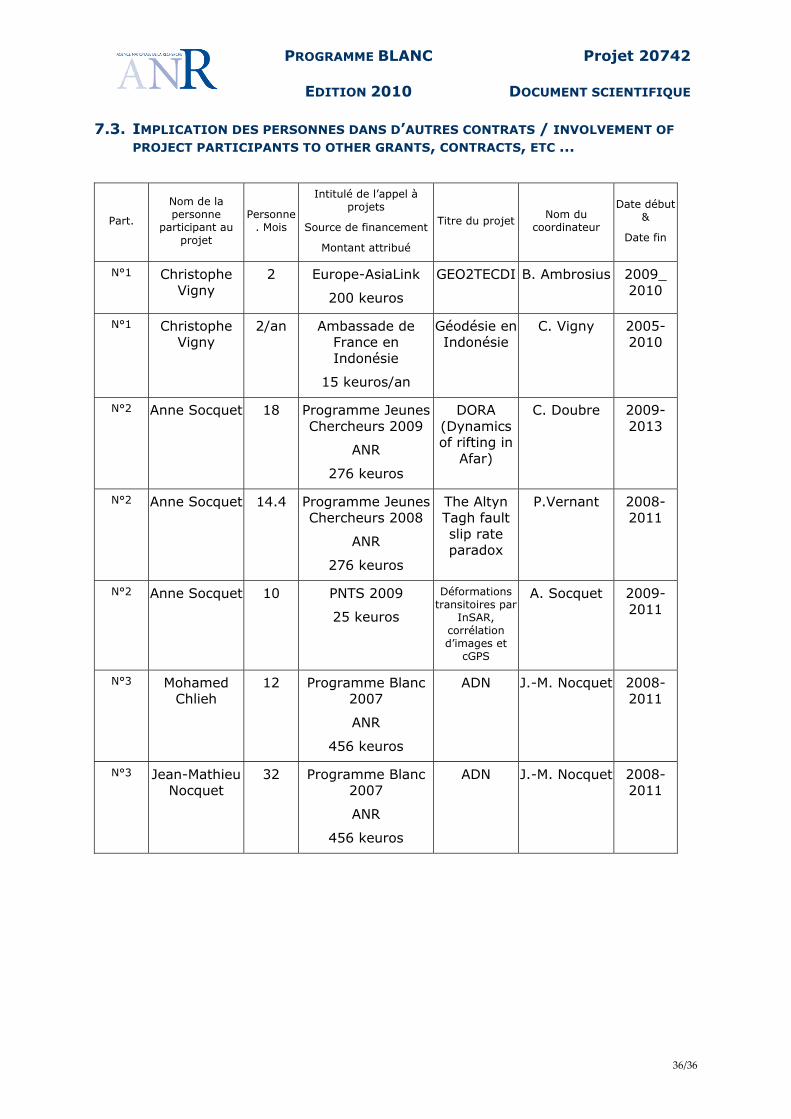
PROGRAMME BLANC
EDITION 2010
Projet 20742
DOCUMENT SCIENTIFIQUE
36/36
7.3. IMPLICATION DES PERSONNES DANS D’AUTRES CONTRATS / INVOLVEMENT OF PROJECT PARTICIPANTS TO OTHER GRANTS, CONTRACTS, ETC …
Part. Nom de la personne
participant au projet
Personne. Mois
Intitulé de l’appel à projets
Source de financement
Montant attribué
Titre du projet Nom du coordinateur
Date début &
Date fin
N°1 Christophe Vigny
2 Europe-AsiaLink
200 keuros
GEO2TECDI B. Ambrosius 2009_ 2010
N°1 Christophe Vigny
2/an Ambassade de France en Indonésie
15 keuros/an
Géodésie enIndonésie
C. Vigny 2005-2010
N°2 Anne Socquet 18 Programme Jeunes Chercheurs 2009
ANR
276 keuros
DORA (Dynamics of rifting in
Afar)
C. Doubre 2009-2013
N°2 Anne Socquet 14.4 Programme Jeunes Chercheurs 2008
ANR
276 keuros
The Altyn Tagh fault slip rate paradox
P.Vernant 2008-2011
N°2 Anne Socquet 10 PNTS 2009
25 keuros
Déformations transitoires par
InSAR, corrélation d’images et
cGPS
A. Socquet 2009-2011
N°3 Mohamed Chlieh
12 Programme Blanc 2007
ANR
456 keuros
ADN J.-M. Nocquet 2008-2011
N°3 Jean-Mathieu Nocquet
32 Programme Blanc 2007
ANR
456 keuros
ADN J.-M. Nocquet 2008-2011